Page 1
Ashford Borough Council | Strategic Housing Land Availability Assessment (SHELAA) Appendix 1
Ashford Borough Council
Strategic Housing
and Employment Land
Availability Assessment
(SHELAA) 2017/18
APPENDIX 1 – All Sites:
Summary List of all sites
Page 2
Ashford Borough Council | Strategic Housing Land Availability Assessment (SHELAA) Appendix 1
Appendix 1 – All Sites Summary List
This Appendix contains details of all sites assessed as part of the SHELAA 2015-2016 in ward
reference order. The final assessment category identifies which appendix the more detailed site
assessment can be located within.
Housing Sites:
Filtered in Part 1 – Detailed assessments in Appendix 2
Filtered in Part 2 – Detailed assessments in Appendix 3
Filtered in Part 3 – Detailed assessments in Appendix 4
Remain in survey - Detailed assessments in Appendix 5
Employment sites – Detailed assessments in Appendix 6
Sites for Other uses – Detailed assessments in Appendix 7
For information on how to locate a site – please see Appendix 10: Site References and Maps
Site
ref
To
wn
/Paris
h/A
rea
Site
Nam
e
Fin
al A
sse
ss
me
nt
Ca
teg
ory
AG1 ASHFORD Klondyke, Newtown Road Remain in Survey - Other Uses
AG2 ASHFORD Housing around New Town Green Filtered at Part 1
AG3 ASHFORD Housing to west of Hunter Avenue Filtered at Part 1
AG4 ASHFORD Housing around Sotherton and Alsops road Filtered at Part 1
AG5 ASHFORD Housing between Bentley and twelve Acres Filtered at Part 1
AG6 ASHFORD Housing North of Breadlands Road including Blake Court Filtered at Part 1
AG7a ASHFORD Newtown Works - Phase 2 Remain in Survey - Housing
AG7b ASHFORD Newtown Works - Phase 1 Filtered at Part 1
AG8 ASHFORD Allotment Land rear of 11-30 Osborne Rd Filtered at Part 1
BAE1 BOUGHTON ALUPH & EASTWELL
Lenacre Hall Farm, 393 Sandyhurst Lane
Neighbourhood plan decision
Page 3
Ashford Borough Council | Strategic Housing Land Availability Assessment (SHELAA) Appendix 1
BAE10 BOUGHTON ALUPH & EASTWELL
Eastwell Manor Hotel, Eastwell Park
Filtered - Employment
BAE11 BOUGHTON ALUPH & EASTWELL Goat Lees Primary School Filtered at Part 1
BAE12 BOUGHTON ALUPH & EASTWELL Land at Fresian Way Filtered at Part 1
BAE13 BOUGHTON ALUPH & EASTWELL
Land adjacent to El Ashere, Wye Road leading to Kempes Corner
Neighbourhood plan decision
BAE14 BOUGHTON ALUPH & EASTWELL
Land adjacent to Aluph House, Pilgrims Way
Neighbourhood plan decision
BAE2 BOUGHTON ALUPH & EASTWELL Former Sandpit, Sandyhurst Lane
Neighbourhood plan decision
BAE3 BOUGHTON ALUPH & EASTWELL
Land adjacent to Gardeners House, Faversham Road
Remain in Survey - Other Uses
BAE4 BOUGHTON ALUPH & EASTWELL Land at Rook Toll, Boughton Lees
Neighbourhood plan decision
BAE5 BOUGHTON ALUPH & EASTWELL Braehead, 198 Sandyhurst Lane,
Neighbourhood plan decision
BAE6 BOUGHTON ALUPH & EASTWELL
Land at Trinity Road/Jersey Rd, Boughton Aluph Filtered at Part 1
BAE7 KENNINGTON Land around Goteley mere, Kennington Filtered at Part 1
BAE8 KENNINGTON 14-32 Grosvenor Road, Kennington Filtered at Part 1
BAE9 KENNINGTON 56-60 and 66-68 Grosvenor Road, Kennington Filtered at Part 1
BBAE1 KENNINGTON Ashford Golf Club, Sandyhurst Lane
Remain in Survey - Housing
BBAE2 KENNINGTON Land at Eureka Park (Policy U17) Remain in Survey - Housing
BBAE2 KENNINGTON Land at Eureka Park (Policy U17) Remain in Survey - Employment
BD1 BIDDENDEN Priorywoods, Tenterden Road, Biddenden
Remain in Survey - Other Uses
BD10 BIDDENDEN Land at Recreation ground at Cheeselands Filtered at Part 1
BD11 BIDDENDEN Estate area around Chulkhurst Filtered at Part 1
BD12 BIDDENDEN Estate around the Weavers Filtered at Part 1
BD13 BIDDENDEN Sissinghurst Road Filtered at Part 1
BD14 BIDDENDEN The Lodge, North Street Filtered at Part 1
BD15 BIDDENDEN Land adjoining Pellhouse Farm, Sissinghurst Road Filtered at Part 1
BD16 BIDDENDEN Worsenden - Orick, New House Farm Filtered at Part 1
Page 4
Ashford Borough Council | Strategic Housing Land Availability Assessment (SHELAA) Appendix 1
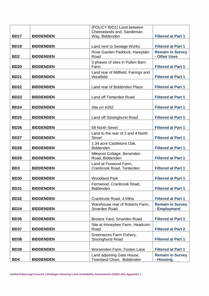
BD17 BIDDENDEN
(POLICY BID1) Land between Cheeselands and, Sandeman Way, Biddenden Filtered at Part 1
BD19 BIDDENDEN Land next to Sewage Works Filtered at Part 1
BD2 BIDDENDEN Rose Garden Paddock, Hareplain Road
Remain in Survey - Other Uses
BD20 BIDDENDEN 3 phases of sites in Pullen Barn Farm Filtered at Part 1
BD21 BIDDENDEN Land rear of Millfield, Fairings and Westfield Filtered at Part 1
BD22 BIDDENDEN Land rear of Biddenden Place Filtered at Part 1
BD23 BIDDENDEN Land off Tenterden Road Filtered at Part 1
BD24 BIDDENDEN Site on A262 Filtered at Part 1
BD25 BIDDENDEN Land off Sissinghurst Road Filtered at Part 1
BD26 BIDDENDEN 58 North Street Filtered at Part 1
BD27 BIDDENDEN Land to the rear of 2 and 4 North Street Filtered at Part 1
BD28 BIDDENDEN 1.34 acre Castletons Oak, Biddenden Filtered at Part 1
BD29 BIDDENDEN Milepost Cottage, Benenden Road, Biddenden Filtered at Part 1
BD3 BIDDENDEN Land at Foxwood Farm, Cranbrook Road, Tenterden Filtered at Part 1
BD30 BIDDENDEN Woodland Park Filtered at Part 1
BD31 BIDDENDEN Fernwood, Cranbrook Road, Biddenden Filtered at Part 1
BD32 BIDDENDEN Cranbrook Road, 4.59ha Filtered at Part 1
BD34 BIDDENDEN Warehouse rear of Roberts Farm, Smarden Road
Remain in Survey - Employment
BD35 BIDDENDEN Browns Yard, Smarden Road Filtered at Part 1
BD37 BIDDENDEN Site at Honeybee Farm, Headcorn Road Filtered at Part 2
BD38 BIDDENDEN Greenacres Farm Fishery, Sissinghurst Road Filtered at Part 1
BD39 BIDDENDEN Worsenden Farm, Fosten Lane Filtered at Part 1
BD4 BIDDENDEN Land adjoining Gate House, Townland Close, Biddenden
Remain in Survey - Housing
Page 5
Ashford Borough Council | Strategic Housing Land Availability Assessment (SHELAA) Appendix 1
BD40 BIDDENDEN Former Railway Station Filtered at part 2
BD5 a BIDDENDEN New House farmland, Rear of Cheeselands, Biddenden Filtered at Part 2
BD5 b BIDDENDEN
Land rear of Cheeselands and Sandeman Way (Larger area than BD5a) Filtered at Part 2
BD6 BIDDENDEN Newcastle Farm Field, Newcastle Corner, Headcorn Road Filtered at Part 2
BD7 BIDDENDEN Little Crampton Meadows Filtered at Part 2
BD8 BIDDENDEN Land at North Street Remain in Survey - Housing
BD9 BIDDENDEN The Meadows Filtered at Part 1
BE1 ASHFORD Housing between St.Annes Road and Cryol Road Filtered at Part 1
BE10 ASHFORD Housing between Watercress Lane and Cross Stile Filtered at Part 1
BE11 ASHFORD Housing between Beaver Lane and Maypits Filtered at Part 1
BE12 ASHFORD Housing at Deans Walk Filtered at Part 1
BE13 ASHFORD Housing between beaver Lane and Flaxpond Road Filtered at Part 1
BE14 ASHFORD Housing at Oak Tree Road and and Harper Road Filtered at Part 1
BE15 ASHFORD Housing between Arlington and Allen Field Filtered at Part 1
BE16 ASHFORD Former Ashford South Primary School (Policy U6A)
Remain in Survey - Housing
BE17 ASHFORD K College, Jemmett Road (Policy U6B)
Remain in Survey - Housing
BE18 ASHFORD Farrow Court, Stanhope Road Remain in Survey - Housing
BE19 ASHFORD Hopewell Primary School, St Stephens Walk Filtered at Part 1
BE2 ASHFORD Housing at Watermead Close Filtered at Part 1
BE20 ASHFORD
Ashford Training Centre, St Stephens Walk, Stanhope TN23 5BD Filtered at Part 1
BE3 ASHFORD Housing east of Cleves Way and west of Beaver Lane Filtered at Part 1
BE4 ASHFORD Housing between Beaver Lane and Crownfield Road Filtered at Part 1
BE5 ASHFORD Housing between Crownfield Road and Brookfield Road Filtered at Part 1
Page 6
Ashford Borough Council | Strategic Housing Land Availability Assessment (SHELAA) Appendix 1
BE6 ASHFORD Housing at Arcon Close Filtered at Part 1
BE7 ASHFORD Housing between Woolreeds Road and Essetford Road Filtered at Part 1
BE8 ASHFORD Housing at Noakes Meadow and west of Jemmet Road Filtered at Part 1
BE9 ASHFORD Housing at Beaver Lane and Watercress Lane Filtered at Part 1
BO1 ASHFORD The Warren, land adjacent Drovers roundabout (Policy U8)
Remain in Survey - Emp & Other Uses
BO10 ASHFORD land of former Kingmead, Bockhanger Lane Filtered at Part 1
BO11 KENNINGTON Highworth Grammar School, Quantock Drive Filtered at Part 1
BO12 ASHFORD Land east of eurogate business park
Remain in Survey - EMPLOYMENT
BO13 KENNINGTON Eureka Leisure Park Remain in Survey - EMPLOYMENT
BO14 KENNINGTON
Land rear of 75-89 Lower Vicarage Road and rear of 16-48 Woodstock Way Filtered at Part 1
BO2 KENNINGTON The Bamboos and Longwood Remain in Survey - Housing
BO3 KENNINGTON
Land around Hurst Road/Rothbrook Drive/Dale Walk, kennington Filtered at Part 1
BO4 KENNINGTON Land at Grasmere Road, Kennington Filtered at Part 1
BO5 KENNINGTON Land west of eurogate Business Park, Kennington Filtered at Part 1
BO6 KENNINGTON land around Mardol Road, Kennington Filtered at Part 1
BO7 ASHFORD Maidstone Road (Policy U9) Filtered at Part 1
BO8 ASHFORD Warren Lane (Policy U18) Filtered at Part 1
BO9 ASHFORD Grosvenor Hall - Former Police training Centre, kennington Filtered at Part 1
BY1 KENNINGTON Ashford Rugby Club (2 submissions) Filtered at Part 2
BY2 KENNINGTON Land around Beecholme drive/Mardol Road, Kennington Filtered at Part 1
BY3 KENNINGTON Bybrook Cemetery and Nine Acres Part 1, Kennington Filtered at Part 1
BY4 KENNINGTON Bybrook Cemetery and Nine Acres Part 2, Kennington Filtered at Part 1
BY5 KENNINGTON Bybrook Road, Kennington Filtered at Part 1
Page 7
Ashford Borough Council | Strategic Housing Land Availability Assessment (SHELAA) Appendix 1
BY6 KENNINGTON Former Phoenix Primary School, Bybrook Road Filtered at Part 1
BY7 KENNINGTON Houchin Playing Fields, Canterbury Road Filtered at Part 2
BY8 KENNINGTON Land opposite of 1-19 Greenbank Filtered at Part 1
BY9 KENNINGTON Bybrook Builders Yard Filtered at Part 2
CG1 CHILMINGTON Chilmington Green Urban Extension
Remain in Survey - Housing
CH1 CHARING Land adjacent Oak Barn, Pett Lane, Charing Filtered at Part 2
CH10 CHARING
Housing estate around Wheeler Road, Downs Way and Clearmont drive Filtered at Part 1
CH11 CHARING Robin Hood Cottage, Canterbury Road Filtered at Part 1
CH12 CHARING
Hitherfield - Land SW of A20 roundabout, Maidstone Road (Policy CHAR2) Filtered at Part 1
CH13 CHARING Land at Parsons Mead Filtered at Part 1
CH14 CHARING Land south of Arthur Baker Playing Field (POLICY CHAR1)
Remain in Survey - Housing
CH15 CHARING Land north west of Five Oaks, Pluckley Road Filtered at Part 1
CH16 CHARING Charing MOT Centre (Charing Motors)
Remain in Survey - Housing
CH17 CHARING Land west of Poppyfields, Charing Remain in survey - Housing
CH18 CHARING East side of A252 Filtered at Part 1
CH19 CHARING Rear of Lyndhurst House Filtered at Part 2
CH2 CHARING Flexford Nurseries, Charing Hill, Charing Filtered at Part 2
CH20 CHARING Land rear of Five Oaks Filtered at Part 1
CH22 CHARING The Slaughterhouse Land Filtered at Part 1
CH23 CHARING KCC Road Depot Filtered at Part 1
CH24 CHARING Land south of Cleardowns, Maidstone Road Filtered at Part 1
CH25 CHARING Brett Aggregates, Hook Lane Filtered at Part 1
CH26 CHARING Land at Moat Park Filtered at Part 1
Page 8
Ashford Borough Council | Strategic Housing Land Availability Assessment (SHELAA) Appendix 1
CH27 CHARING Sayer Road Filtered at Part 1
CH28 CHARING Land rear of Palace Corner to Seymour (The Hill) Filtered at Part 1
CH29 CHARING Charing Primary School grounds Filtered at Part 1
CH3 CHARING Land west of Pluckley Road, Charing Filtered at Part 2
CH31 CHARING Sports Pavilion, Arthur Baker Playing Fields, The Moat Other uses
CH32 CHARING Land rear of Little Minden and Millgarth, The Hill, Charing Filtered at Part 1
CH33 Charing Yew Tree Park Homes, Maidstone Road
Remain in Survey - Housing
CH4 CHARING Northdowns Service Station, A20 Charing
Remain in Survey - Housing
CH5 CHARING Land at Charing Hill (adjoining Lyndhurst House) Filtered at part 2
CH6 CHARING Land at the top of Charing Hill Remain in Survey - Housing
CH7 CHARING Land on western side of Pluckley Road Filtered at Part 2
CH8 CHARING The Abbaoir, Dog Kennel Lane, (Anglo Dutch Meats Ltd) Filtered at Part 2
CH9 CHARING Land adjoining Burleigh Bungalow, Burleigh Road
Remain in Survey - Housing
DN1 CHILHAM Land between Cobbs Hill and Long Hill, Old Wives Lees Filtered at Part 2
DN10 CHILHAM Land off A262 Filtered at Part 1
DN11 CHILHAM Land off Bagham Road Filtered at Part 1
DN12 CHILHAM The Avenue Field, Bagham Road Remain in Survey - Housing
DN13 CHILHAM
Land between Bagham Road, Arden Grange and the Recreation Ground
Remain in Survey - Housing
DN14 CHILHAM Sylvilla, Canterbury Road Filtered at Part 1
DN15 CHILHAM Rare Animal Compound, The Old Depot Filtered at Part 1
DN16 CHILHAM Field adjacent to the Bothy, Church Hill Filtered at Part 1
DN17 CHILHAM Rare Animal Compound Filtered at Part 1
DN18 CHILHAM Site on intersection of Taylors Hill and A252 Filtered at Part 1
Page 9
Ashford Borough Council | Strategic Housing Land Availability Assessment (SHELAA) Appendix 1
DN19 CHILHAM Mountain Street Filtered at Part 1
DN2 CHILHAM Land at Harvest House, Branch Road
Remain in Survey - Housing
DN20 MOLASH Land in Molash - The Street. Martin Lodge Farm Filtered at Part 1
DN21 OLD WIVES LEES Land adjacent to Phyllis Farm Filtered at Part 1
DN22 MOLASH Land adjacent to Shottenden Lane Filtered at Part 1
DN23 OLD WIVES LEES Phyllis Farm Filtered at Part 1
DN24 CHILHAM Land at Prior Oast House Filtered at Part 1
DN25 CHILHAM Land at East Stour Farm Filtered at Part 1
DN26 CHILHAM Maslow Court, Canterbury Road Filtered at Part 1
DN27 CHILHAM Land east of Station Approach Filtered at Part 1
DN28 GODEMERSHAM Bilting Farm Business Centre, Bilting
Filtered - Employment
DN29 CHILHAM
Land at 1-5 The Oast House, Lower Lees Road, Old Wives Lees Filtered at Part 2
DN3 CHILHAM Ashford Road Service Station, Ashford Road Filtered at Part 2
DN30 CHILHAM Land between Long Hill & Hawkin's Rough, Old Wives Lees Filtered at Part 2
DN31 CHILHAM Land adjacent to Tollgate Cottage, Maidstone Road Filtered at Part 2
DN32 MOLASH Land adjacent to Pound Lane, Molash Filtered at Part 2
DN33 MOLASH Northdown Residential Care Home Filtered at Part 1
DN4 CHILHAM Land at Mulberry Hill Filtered at Part 2
DN5 CHILHAM Noveis, Canterbury Road Filtered at Part 2
DN6 MOLASH Land adjacent to No1 Pound lane cottages, Molash Filtered at Part 1
DN7 MOLASH Land at Church Lane, Molash Filtered at Part 1
DN8 CHILHAM Housing Estate at Felborough Close Filtered at Part 1
DN9 CHILHAM Former Chilham Sawmill (Policy CHIL1) Filtered at Part 1
Page 10
Ashford Borough Council | Strategic Housing Land Availability Assessment (SHELAA) Appendix 1
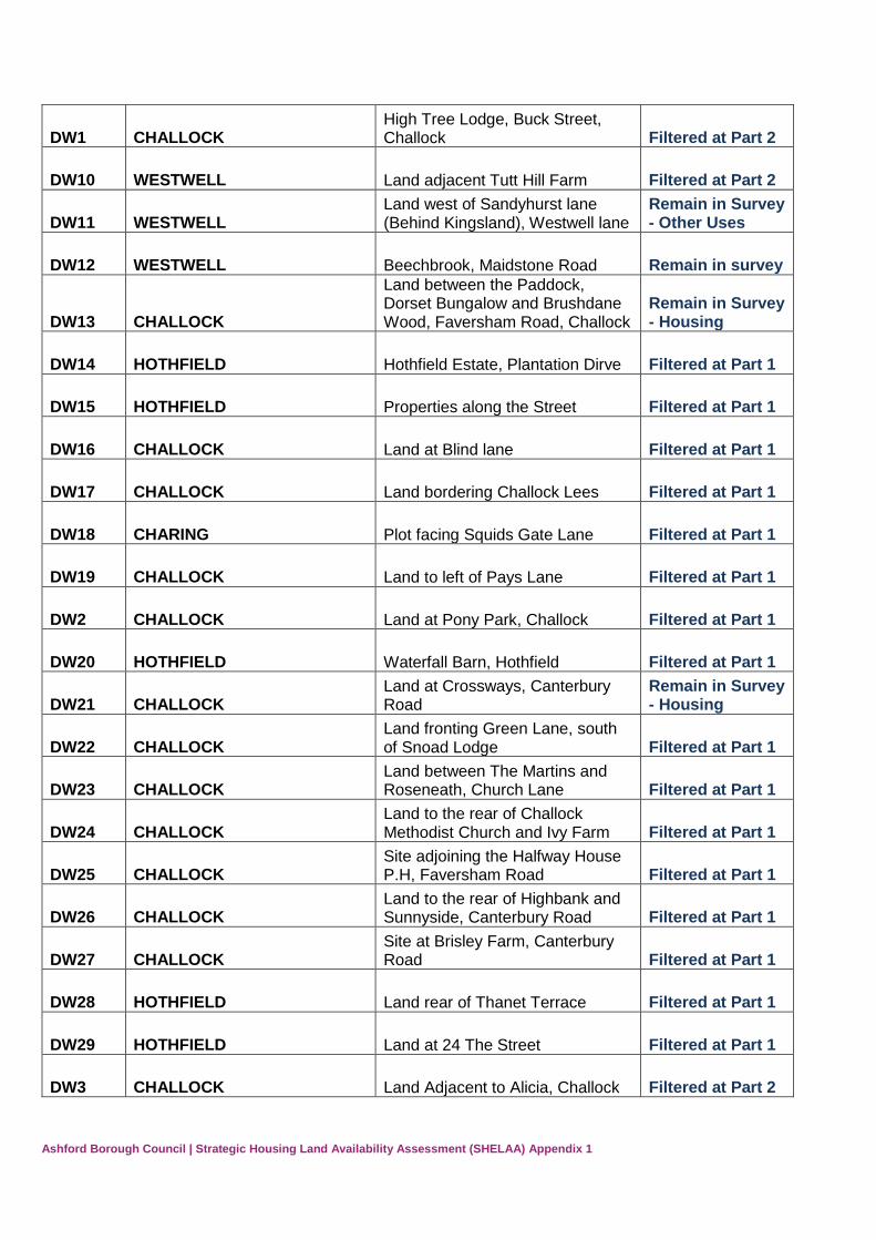
DW1 CHALLOCK High Tree Lodge, Buck Street, Challock Filtered at Part 2
DW10 WESTWELL Land adjacent Tutt Hill Farm Filtered at Part 2
DW11 WESTWELL Land west of Sandyhurst lane (Behind Kingsland), Westwell lane
Remain in Survey - Other Uses
DW12 WESTWELL Beechbrook, Maidstone Road Remain in survey
DW13 CHALLOCK
Land between the Paddock, Dorset Bungalow and Brushdane Wood, Faversham Road, Challock
Remain in Survey - Housing
DW14 HOTHFIELD Hothfield Estate, Plantation Dirve Filtered at Part 1
DW15 HOTHFIELD Properties along the Street Filtered at Part 1
DW16 CHALLOCK Land at Blind lane Filtered at Part 1
DW17 CHALLOCK Land bordering Challock Lees Filtered at Part 1
DW18 CHARING Plot facing Squids Gate Lane Filtered at Part 1
DW19 CHALLOCK Land to left of Pays Lane Filtered at Part 1
DW2 CHALLOCK Land at Pony Park, Challock Filtered at Part 1
DW20 HOTHFIELD Waterfall Barn, Hothfield Filtered at Part 1
DW21 CHALLOCK Land at Crossways, Canterbury Road
Remain in Survey - Housing
DW22 CHALLOCK Land fronting Green Lane, south of Snoad Lodge Filtered at Part 1
DW23 CHALLOCK Land between The Martins and Roseneath, Church Lane Filtered at Part 1
DW24 CHALLOCK Land to the rear of Challock Methodist Church and Ivy Farm Filtered at Part 1
DW25 CHALLOCK Site adjoining the Halfway House P.H, Faversham Road Filtered at Part 1
DW26 CHALLOCK Land to the rear of Highbank and Sunnyside, Canterbury Road Filtered at Part 1
DW27 CHALLOCK Site at Brisley Farm, Canterbury Road Filtered at Part 1
DW28 HOTHFIELD Land rear of Thanet Terrace Filtered at Part 1
DW29 HOTHFIELD Land at 24 The Street Filtered at Part 1
DW3 CHALLOCK Land Adjacent to Alicia, Challock Filtered at Part 2
Page 11
Ashford Borough Council | Strategic Housing Land Availability Assessment (SHELAA) Appendix 1
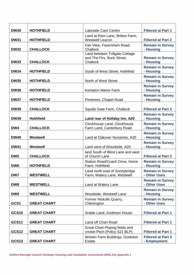
DW30 HOTHFIELD Lakeside Care Centre Filtered at Part 1
DW31 HOTHFIELD Land at Ram Lane, Britton Farm, Westwell Leacon Filtered at Part 2
DW32 CHALLOCK Fair View, Faversham Road, Challock
Remain in Survey - Housing
DW33 CHALLOCK
Land between Tollgate Cottage and The Firs, Buck Street, Challock
Remain in Survey - Housing
DW34 HOTHFIELD South of West Street, Hothfield Remain in Survey - Housing
DW35 HOTHFIELD North of West Street Remain in Survey - Housing
DW36 HOTHFIELD Kempton Manor Farm Remain in Survey - Housing
DW37 HOTHFIELD Pinetrees, Chapel Road Remain in Survey - Housing
DW38 CHALLOCK Squids Gate Farm, Challock Filtered at Part 2
DW39 Hothfield Land rear of Holiday Inn, A20 Remain in Survey - Housing
DW4 CHALLOCK Clockhouse Land, Clockhouse Farm Land, Canterbury Road
Remain in Survey - Housing
DW40 Westwell Land at Oakover Nurseries, A20 Remain in Survey - Housing
DW41 Westwell Land west of Woodside, A20 Remain in Survey - Housing
DW5 CHALLOCK land South of Blind Lane and west of Church Lane Filtered at Part 2
DW6 HOTHFIELD Station Road/Coach Drive, Home Farm, Hothfield
Remain in Survey - Housing
DW7 WESTWELL Land north east of Sunnybridge Farm, Watery Lane, Westwell
Remain in Survey - Other Uses
DW8 WESTWELL Land at Watery Lane Remain in Survey - Other Uses
DW9 WESTWELL Woodside, Westwell Lane Remain in Survey - Housing
GCS1 GREAT CHART Former Nickolls Quarry, Chilmington
Remain in Survey - Other Uses
GCS10 GREAT CHART Arable Land, Godinton House Filtered at Part 1
GCS11 GREAT CHART Land off Chart Road Filtered at Part 1
GCS12 GREAT CHART Great Chart Playing fields and cricket Pitch (Policy S21 BLP) Filtered at Part 1
GCS13 GREAT CHART Worten Farm Buildings, Godinton Estate
Filtered at Part 3 - Employment
Page 12
Ashford Borough Council | Strategic Housing Land Availability Assessment (SHELAA) Appendix 1
GCS14 GREAT CHART Ninn Lane Site Filtered at Part 2
GCS15 GREAT CHART Site of former Great Chart Motors Remain in Survey - Housing
GCS2 GREAT CHART The Meadows, Sandy Lane, Great Chart
Remain in Survey - Other Uses
GCS4 GREAT CHART Pig and Whistle, Ashford Road Filtered at Part 3
GCS5 GREAT CHART A28 Bethersden Road (Land north of Possingham Farmhouse) Filtered at Part 3
GCS6 GREAT CHART Land adjacent Chart Leacon Cottages, Chart Road Filtered at Part 1
GCS7 GREAT CHART Housing at Hillcrest, Great Chart Filtered at Part 1
GCS8 GREAT CHART Housing to West of Singleton Road, Great Chart Filtered at Part 1
GCS9 GREAT CHART Blue Barn Filtered at Part 1
GO1 ASHFORD Residential Housing estate east of Maidstone Road Filtered at Part 1
GO10 Central Ashford Land at corner of Maidstone Road and Templer Way Filtered at Part 1
GO11 Central Ashford Land East of Sweetbay Crescent Filtered at Part 1
GO2 ASHFORD Amenity Space at Loudon Way/Cedar Close Filtered at Part 1
GO3 ASHFORD Land at Brunswick Road Industrial Estate Filtered at Part 1
GO4 ASHFORD Former Godinton Way Industrial Estate (Policy TC8)
Remain in Survey - Housing
GO5 ASHFORD Former Ashford Hospital, Kings Ave (Policy U10)
Remain in Survey - Housing
GO6 ASHFORD Cobbs Wood Industrial Estate Remain in Survey - EMPLOYMENT
GO7 ASHFORD
Land at the corner of Carlton Rd and Brunswick Rd, Cobbs Wood Industrial Estate (Former Rimmel Site)
Remain in Survey - EMPLOYMENT
GO8 Central Ashford Former Rowcroft and Templer Barracks (REPTON PARK)
Remain in Survey - Housing
GO9 Central Ashford Rear of 189 and 209 Godinton Road Filtered at Part 1
HG1 SEVINGTON Land adjacent to Church Road, Sevington Filtered at Part 2
HG2 SEVINGTON
Open Spaces around around Luckhurst Road/North East of Sevington Filtered at Part 2
HG3 SEVINGTON Orbital Park (Policy U16) Remain in Survey - EMPLOYMENT
Page 13
Ashford Borough Council | Strategic Housing Land Availability Assessment (SHELAA) Appendix 1
HG4 SEVINGTON Kingston House, The Long Barrow, Sevington
Remain in Survey - EMPLOYMENT
HG5 SEVINGTON Unit G, Ashford Business Park, Foster Road
Remain in Survey - EMPLOYMENT
HG6 SEVINGTON Ashford Business Park, Sevington (whole site)
Remain in Survey - EMPLOYMENT
IO1 APPLEDORE Land south east of May House, tenterden Road Filtered at Part 1
IO10 WITTERSHAM Stocks Road, Wittersham Filtered at Part 1
IO11 WITTERSHAM land at Woodland View, Wittersham
Remain in Survey - Housing
IO12 KENARDINGTON Cherry Croft Filtered at Part 1
IO13 STONE 3.7 ha at Stone in Oxney Filtered at Part 1
IO14 APPLEDORE land south of Court Lodge Road Filtered at Part 1
IO15 APPLEDORE Land Adjacent to Heath Bungalows Filtered at Part 1
IO16 WITTERSHAM Sweatmans Garage, Poplar Road Filtered at Part 1
IO17 APPLEDORE Land abutting 1 and land between 12 & 13 Hawthorn Filtered at Part 1
IO18 KENARDINGTON Land Opposite Spring Cottages, Appledore Road Filtered at Part 1
IO19 KENARDINGTON St Mary's Church, Kenardington Other uses
IO2 APPLEDORE Land rear of Appledore Village Hall and Doctors Surgery
Remain in Survey - Housing
IO20 APPLEDORE Pines Farm, Tenterden Road Filtered - Employment
IO21 STONE-CUM-EBONY Odiam farm, Lower Road Filtered - Employment
IO22a APPLEDORE The Walnut Field Remain in Survey - Housing
IO22b APPLEDORE The Quillet Filtered at Part 1
IO23 APPLEDORE Land at 1 The Street, Appledore Filtered at Part 1
IO24 APPLEDORE Railway Hotel, Station Road, Appledore Filtered at Part 1
IO25 WITTERSHAM Land adjoining Poplar Farm, Poplar Farm
Remain in Survey - Housing
IO26 APPLEDORE Gusbourne Estate Vineyard Filtered - Employment
IO27 APPLEDORE Park Farm Barn, School Road Filtered - Employment
Page 14
Ashford Borough Council | Strategic Housing Land Availability Assessment (SHELAA) Appendix 1
IO28 APPLEDORE Magpie Farm, The Street Remain in Survey - Housing
IO29 APPLEDORE School Field, School Lane Filtered at Part 2
IO3 KENARDINGTON Land at High House Farm, Kenardington Filtered at Part 2
IO30 APPLEDORE Land Wst of School Road Filtered at Part 2
IO4 KENARDINGTON High House Nursery, Kenardington
Remain in Survey - Other Uses
IO5 WITTERSHAM Land at Lloyds Farm Filtered at Part 2
IO6 WITTERSHAM Land north of Stocks Road, Wittersham Filtered at Part 2
IO7 WITTERSHAM
Jubilee Fields, Land adjoining North East boundary of Jubille Fields, Wittersham Filtered at Part 3
IO8 WITTERSHAM
Housing at Forge Meads, Jubilee Fields and Woodland View (Covers area of IO7) Filtered at Part 1
IO9 KENARDINGTON Paddock at Pockets Cottage, Church Lane Filtered at Part 2
KE1 KENNINGTON Land at Ulley Farm, Ball Lane, Kennington Filtered at Part 3
KE10 KENNINGTON The Bungalow, the Croft Hotel, Canterbury Road
Remain in Survey - Housing
KE11 KENNINGTON Land rear of 88 The Street Remain in Survey - Housing
KE12 KENNINGTON Rosedene, Grosvenor Road Remain in Survey - Housing
KE13 KENNINGTON The Old Mill, Canterbury Road Filtered at Part 1
KE14 KENNINGTON Little Acre, 80 The Street, Kennington Filtered at Part 2
KE15 KENNINGTON Old School House, Ball Lane Filtered at Part 2
KE2 KENNINGTON Orchard Farm, Kennington Filtered at Part 3
KE3 KENNINGTON Land NE of A2070 Willesborough Road
Remain in Survey - Housing
KE4 KENNINGTON Land east of A28 Filtered at Part 3
KE5 KENNINGTON The Croft Hotel, Canterbury Road Filtered at Part 3
KE6 KENNINGTON Allotments near Glebe Way, kennington Filtered at Part 1
KE7 KENNINGTON Cricket And Hockey Club Filtered at Part 1
Page 15
Ashford Borough Council | Strategic Housing Land Availability Assessment (SHELAA) Appendix 1
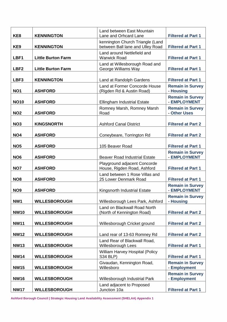
KE8 KENNINGTON Land between East Mountain Lane and Orhcard Lane Filtered at Part 1
KE9 KENNINGTON kennington Church Triangle (Land between Ball lane and Ulley Road Filtered at Part 1
LBF1 Little Burton Farm Land around Nettlefield and Warwick Road Filtered at Part 1
LBF2 Little Burton Farm Land at Willesborough Road and George Williams Way Filtered at Part 1
LBF3 KENNINGTON Land at Randolph Gardens Filtered at Part 1
NO1 ASHFORD Land at Former Concorde House (Rigden Rd & Austin Road)
Remain in Survey - Housing
NO10 ASHFORD Ellingham Industrial Estate Remain in Survey - EMPLOYMENT
NO2 ASHFORD Romney Marsh, Romney Marsh Road
Remain in Survey - Other Uses
NO3 KINGSNORTH Ashford Canal District Filtered at Part 2
NO4 ASHFORD Coneybeare, Torrington Rd Filtered at Part 2
NO5 ASHFORD 105 Beaver Road Filtered at Part 1
NO6 ASHFORD Beaver Road Industrial Estate Remain in Survey - EMPLOYMENT
NO7 ASHFORD Playground adjacent Concorde House, Rigden Road, Ashford Filtered at Part 1
NO8 ASHFORD Land between 1 Rose Villas and 25 Lower Denmark Road Filtered at Part 1
NO9 ASHFORD Kingsnorth Industrial Estate Remain in Survey - EMPLOYMENT
NW1 WILLESBOROUGH Willesborough Lees Park, Ashford Remain in Survey - Housing
NW10 WILLESBOROUGH Land on Blackwall Road North (North of Kennington Road) Filtered at Part 2
NW11 WILLESBOROUGH Willesborough Cricket ground Filtered at Part 2
NW12 WILLESBOROUGH Land rear of 13-63 Romney Rd Filtered at Part 2
NW13 WILLESBOROUGH Land Rear of Blackwall Road, Willesborough Lees Filtered at Part 1
NW14 WILLESBOROUGH William Harvey Hospital (Policy S34 BLP) Filtered at Part 1
NW15 WILLESBOROUGH Givaudan, Kennington Road, Willesboro
Remain in Survey - Employment
NW16 WILLESBOROUGH Willesborough Industrial Park Remain in Survey - Employment
NW17 WILLESBOROUGH Land adjacent to Proposed Junction 10a Filtered at Part 1
Page 16
Ashford Borough Council | Strategic Housing Land Availability Assessment (SHELAA) Appendix 1
NW18 WILLESBOROUGH Land adjacent to 13 Fountains close, willesborough Lees Filtered at Part 1
NW19 WILLESBOROUGH Land to rear of Summer Hill House, Hythe Road
Remain in Survey - Housing
NW2 WILLESBOROUGH Land at 10A Blackwall Road North Filtered at Part 2
NW3 WILLESBOROUGH Land adjacent to Julie Rose Stadium
Remain in Survey - Housing
NW4 WILLESBOROUGH Housing and Land to North of Osborne Road Filtered at Part 1
NW5 WILLESBOROUGH Land off Abbey Way, Willesborough Lees (Policy U1)
Remain in Survey - Housing
NW6 WILLESBOROUGH Land at Blackwall Road, Willesborough Lees (Policy U5)
Remain in Survey - Housing
NW7 WILLESBOROUGH land At Willesborough Lees (Policy U14)
Remain in Survey - Housing
NW8 WILLESBOROUGH Conningbrook Strategic Park (Policy U22)
Remain in Survey - Housing
NW9 WILLESBOROUGH Land adjacent to William Harvey hospital Filtered at Part 1
PFN1 PARK FARM Land at the Northern end of Saddlers Way, Park Farm Filtered at Part 1
PFN2 KINGSNORTH Missenden, Kingsnorth Road Filtered at Part 1
PFN3 KINGSNORTH Land adjacent to Kingsnorth Medical Practice Filtered at Part 2
PFN4 KINGSNORTH Triumvirate House, Millbank Road (Imagine play centre) Filtered at Part 2
RTW1 ROLVENDEN Copfield farm, Rolvenden Neighbourhood plan decision
RTW10 TENTERDEN Korkers Sausage Factory Filtered at Part 1
RTW11 ROLVENDEN Rear of Sparkeswood Neighbourhood plan decision
RTW12 TENTERDEN Land at back of Regent Street Filtered at Part 1
RTW13 TENTERDEN Allotment site - Tenterden Road Filtered at Part 1
RTW14 TENTERDEN Plummers Lane Filtered at Part 1
RTW15 TENTERDEN Land at Tanyard, Rolvenden Road Filtered at Part 1
RTW16 TENTERDEN Land on intersection of Plummer Lane and Rolvenden Road Filtered at Part 1
RTW17 ROLVENDEN Land at Winser Road, Rolvenden Layne Filtered at Part 1
RTW18 ROLVENDEN Thornden Road, Rolvenden Layne Filtered at Part 1
Page 17
Ashford Borough Council | Strategic Housing Land Availability Assessment (SHELAA) Appendix 1
RTW19 ROLVENDEN Great Maytham Hall, Maytham Road, Rolvenden Filtered at Part 1
RTW2 TENTERDEN Pickhill Business centre Remain in Survey - EMPLOYMENT
RTW20 NEWENDEN Rother Valley Farm Bungalow, Lossenham Lane Filtered at Part 1
RTW21 ROLVENDEN Kingsgate View, Mounts Lane, Rolvenden Layne Filtered at Part 2
RTW22 ROLVENDEN land to the west of Kingsgate Cottage, Rolvenden Layne Filtered at Part 2
RTW23 TENTERDEN Pittlesden Farm, Station Road Filtered at Part 1
RTW24 TENTERDEN Tenterden Vineyard, Small Hythe Road
Remain in Survey - Other Uses
RTW25 ROLVENDEN Windmill House Meadow, Benenden Road, Rolvenden
Neighbourhood plan decision
RTW26 ROLVENDEN Land opposite West Lodge, Hastings Road, Rolvenden
Neighbourhood plan decision
RTW27 ROLVENDEN Cornex Garage, High Street, Rolvenden
Neighbourhood plan decision
RTW28 ROLVENDEN Thornden Field (N), Thornden Lane, Rolvenden Layne
Neighbourhood plan decision
RTW29 ROLVENDEN South Field, Thornden Lane, Rolvenden Layne
Neighbourhood plan decision
RTW3 ROLVENDEN Gatefield Cottages Filtered at Part 1
RTW30 ROLVENDEN Land north of Frogs Lane, Rolvenden Layne
Neighbourhood plan decision
RTW31 ROLVENDEN Dallens, Frogs Lane, Rolvenden Layne
Neighbourhood plan decision
RTW4 TENTERDEN Halden Lane Filtered at Part 1
RTW5 TENTERDEN Land adjoining Windsmill Farm Filtered at Part 1
RTW6 ROLVENDEN
Rolvenden Football Field, Tenterden Road (POLICY ROLV1)
Remain in Survey - Housing
RTW7 TENTERDEN 12 Acres of land along A28 Tenterden Road Filtered at Part 1
RTW8 TENTERDEN Field adjacent to cricket ground Filtered at Part 1
RTW9 ROLVENDEN Land adjacent to Redwood Filtered at Part 2
SH1 STANHOPE 1 Stanhope Court Extant Permission
SH2 STANHOPE Playground north of The Limes Filtered at Part 1
Page 18
Ashford Borough Council | Strategic Housing Land Availability Assessment (SHELAA) Appendix 1
SIS1 SINGLETON Bishops Green (Butt Field Road), Singleton (Policy U11)
Remain in Survey - Housing
SIS2 SINGLETON Land between Strouts Road and Hoxton Close Filtered at Part 1
SIS3 SINGLETON Land west of Knoll Lane Filtered at Part 1
SM1 TENTERDEN Adjacent to Beechwood Farm, St Michaels Filtered at Part 1
SM2 TENTERDEN Housing around Marshalls land Filtered at Part 1
SM3 TENTERDEN Land adjacent to London Beach Hotel Filtered at Part 1
SM4 TENTERDEN Land and buildings at High Chimney Farm, Biddenden Road Filtered at Part 1
SM5 TENTERDEN land rear of 1 & 2 Holly Cottage, the Pavement, tenterden Filtered at Part 1
SM6 TENTERDEN Ingleden Park Riding School, Ingleden Park Road
Filtered - Employment
SM7 TENTERDEN Ashburnham Nursery, Ashford Road
Filtered - Employment
SM8 TENTERDEN Little Orchards, Ashford Road, St Michaels
Remain in Survey - Housing
SM9 TENTERDEN Little Hill, Ashford Road, St Michaels Filtered at part 1
SS1 ALDINGTON Abbatoir, Coopers Field, Roman Road, Aldington
Remain in Survey - Housing
SS10 BONNINGTON The Paddock, east of Bonnington Court Filtered at Part 2
SS11 BONNINGTON Land north east of Bonnington Court Filtered at Part 2
SS12 BROOK Nats Lane, The Street, Brook Remain in Survey - Housing
SS13 BRABOURNE Housing at the Warren and Manse Field Filtered at Part 1
SS14 SMEETH Housing at Calland Filtered at Part 1
SS15 ALDINGTON Housing at Earlsfield and walnut Ridge Filtered at Part 1
SS16 ALDINGTON Yard and Farm Buildings - Frith Road Filtered at Part 1
SS17 ALDINGTON
Land adjacent to the Old Telephone Exchange, Roman Road Filtered at Part 1
SS18 ALDINGTON Infill Site: Forge Hill Filtered at Part 1
SS19 ALDINGTON Vale Farm Buildings, Mill Lane Filtered at Part 1
Page 19
Ashford Borough Council | Strategic Housing Land Availability Assessment (SHELAA) Appendix 1
SS2 ALDINGTON Land adjacent to 'By-The-Way', Frith Road, Aldington Filtered at Part 1
SS20 ALDINGTON Land adjacent Poulton Manor Farm - Frith Road Filtered at Part 1
SS21 ALDINGTON Land adjacent to Poulton Oast, Frith Road Filtered at Part 1
SS22 ALDINGTON Land wraps round southern edge of village Filtered at Part 1
SS23 ALDINGTON Goodwin Farm Filtered at Part 1
SS24 ALDINGTON Land adjacent to Mill Lane (Aldington Mill) Filtered at Part 1
SS25 ALDINGTON Land at Vale Farm, Dickson Bourne Lane Filtered at Part 1
SS26 ALDINGTON Handen Farm Cottage Filtered at Part 1
SS27 ALDINGTON Disused Quarry - Calleywell Lane Filtered at Part 1
SS28 ALDINGTON Land adjoining Homelands, Forge Hill Road Filtered at Part 1
SS29 SMEETH Land rear of Fortescue Place, Calland
Remain in Survey - Housing
SS3 ALDINGTON Land south and West of Quarry Wood, Aldington (Policy ALD1)
Remain in Survey - Housing
SS30 SMEETH May Cottage, Smeeth Filtered at Part 1
SS31 RUCKINGE Woodreeve Farm, Ruckinge Filtered at Part 1
SS32 RUCKINGE Land in Bromley Green Road- East of Woodfield Farm Filtered at Part 1
SS33 HASTINGLEIGH Old Saw Mill Filtered at Part 1
SS34 BROOK Land at Sunnybrook Stables, The Street, Brook TN25 5PF Filtered at Part 1
SS35 BILSINGTON Red Willows, Priory Road, Aldington Frith Filtered at Part 1
SS36 ALDINGTON Cranbourne Cottage, Frith Road, Aldington frith Filtered at Part 1
SS37 RUCKINGE Land adjacent to Hazels, Bromley Green Road Filtered at Part 1
SS38 RUCKINGE
Land adjacent to Sherwood, Bromley Green Road, Upper Ruckinge Filtered at Part 1
SS39 BILSINGTON
Land at Bliby Wood, comprising of Casa Amica and Ripleys Breakers Yard Filtered at Part 1
SS4 ALDINGTON Land east of Goldwell Lane, Aldington
Remain in Survey - Housing
Page 20
Ashford Borough Council | Strategic Housing Land Availability Assessment (SHELAA) Appendix 1
SS40 BRABOURNE Kimberley Farm, Granary Court Road Filtered at Part 1
SS41 BROOK Site in Nats Lane Brook Filtered at Part 1
SS42 RUCKINGE
2 parcels of Land at southeast corner crossroads hamstreet road and Bromley Green Road Intersect Filtered at Part 1
SS43 RUCKINGE
17 acres of land rear of Dimon Cottage, Misteltoe Cottage and Dimon Villa Filtered at Part 2
SS44 ALDINGTON Woodleas farm, Goldwell Lane Filtered at Part 1
SS45 ALDINGTON The Beeches, Camber Bourne Lane Filtered at Part 1
SS46 ALDINGTON Land adjacent to Cranbourne Cottage, Frith Road Filtered at Part 1
SS49 BRABOURNE East Barn at Penstock Hall Farm, Canterbury Road Filtered at Part 1
SS5 ALDINGTON Land between Roman Road and Goldwell Lane
Remain in Survey - Housing
SS51 SMEETH The Wood Turners, Church Road Remain in Survey - EMPLOYMENT
SS53 SMEETH Evegate Business Centre Filtered - Employment
SS54 SMEETH Additional land on Church Road Remain in Survey - Housing
SS55 ALDINGTON The Paddock, Vale Farm House, Mill Lane Filtered at Part 2
SS56 SMEETH Mersham-le-Hatch Business Village
Filtered - Employment
SS57 BRABOURNE Brabourne Lees - land between Canterbury road and Lees Road Filtered at Part 2
SS58 SMEETH Land at The Caldecott Foundation School
Remain in Survey - Housing
SS59 SMEETH Smeeth Playing Fields Filtered at Part 2
SS6 BONNINGTON Land at Bonnington Filtered at Part 2
SS7 SMEETH Land at Church Road Remain in Survey - Housing
SS8 SMEETH Old Builders Yard, Plain road Remain in Survey - Housing
SS9 SMEETH
Land at the junction between Evegate Mill Lane and Bower Road, Smeeth Filtered at Part 2
ST1 ASHFORD Riverside Business Park Filtered - Employment
Page 21
Ashford Borough Council | Strategic Housing Land Availability Assessment (SHELAA) Appendix 1
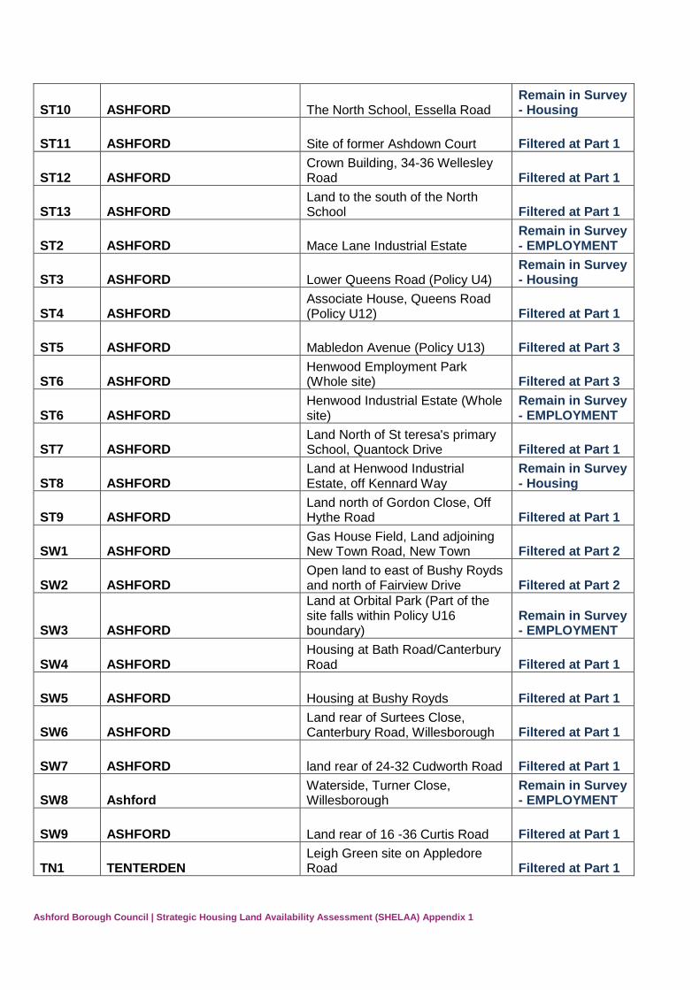
ST10 ASHFORD The North School, Essella Road Remain in Survey - Housing
ST11 ASHFORD Site of former Ashdown Court Filtered at Part 1
ST12 ASHFORD Crown Building, 34-36 Wellesley Road Filtered at Part 1
ST13 ASHFORD Land to the south of the North School Filtered at Part 1
ST2 ASHFORD Mace Lane Industrial Estate Remain in Survey - EMPLOYMENT
ST3 ASHFORD Lower Queens Road (Policy U4) Remain in Survey - Housing
ST4 ASHFORD Associate House, Queens Road (Policy U12) Filtered at Part 1
ST5 ASHFORD Mabledon Avenue (Policy U13) Filtered at Part 3
ST6 ASHFORD Henwood Employment Park (Whole site) Filtered at Part 3
ST6 ASHFORD Henwood Industrial Estate (Whole site)
Remain in Survey - EMPLOYMENT
ST7 ASHFORD Land North of St teresa's primary School, Quantock Drive Filtered at Part 1
ST8 ASHFORD Land at Henwood Industrial Estate, off Kennard Way
Remain in Survey - Housing
ST9 ASHFORD Land north of Gordon Close, Off Hythe Road Filtered at Part 1
SW1 ASHFORD Gas House Field, Land adjoining New Town Road, New Town Filtered at Part 2
SW2 ASHFORD Open land to east of Bushy Royds and north of Fairview Drive Filtered at Part 2
SW3 ASHFORD
Land at Orbital Park (Part of the site falls within Policy U16 boundary)
Remain in Survey - EMPLOYMENT
SW4 ASHFORD Housing at Bath Road/Canterbury Road Filtered at Part 1
SW5 ASHFORD Housing at Bushy Royds Filtered at Part 1
SW6 ASHFORD Land rear of Surtees Close, Canterbury Road, Willesborough Filtered at Part 1
SW7 ASHFORD land rear of 24-32 Cudworth Road Filtered at Part 1
SW8 Ashford Waterside, Turner Close, Willesborough
Remain in Survey - EMPLOYMENT
SW9 ASHFORD Land rear of 16 -36 Curtis Road Filtered at Part 1
TN1 TENTERDEN Leigh Green site on Appledore Road Filtered at Part 1
Page 22
Ashford Borough Council | Strategic Housing Land Availability Assessment (SHELAA) Appendix 1
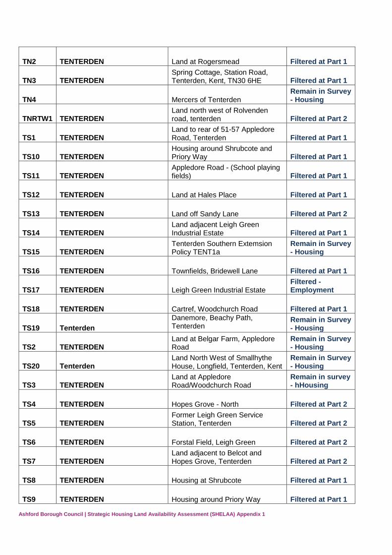
TN2 TENTERDEN Land at Rogersmead Filtered at Part 1
TN3 TENTERDEN Spring Cottage, Station Road, Tenterden, Kent, TN30 6HE Filtered at Part 1
TN4 Mercers of Tenterden Remain in Survey - Housing
TNRTW1 TENTERDEN Land north west of Rolvenden road, tenterden Filtered at Part 2
TS1 TENTERDEN Land to rear of 51-57 Appledore Road, Tenterden Filtered at Part 1
TS10 TENTERDEN Housing around Shrubcote and Priory Way Filtered at Part 1
TS11 TENTERDEN Appledore Road - (School playing fields) Filtered at Part 1
TS12 TENTERDEN Land at Hales Place Filtered at Part 1
TS13 TENTERDEN Land off Sandy Lane Filtered at Part 2
TS14 TENTERDEN Land adjacent Leigh Green Industrial Estate Filtered at Part 1
TS15 TENTERDEN Tenterden Southern Extemsion Policy TENT1a
Remain in Survey - Housing
TS16 TENTERDEN Townfields, Bridewell Lane Filtered at Part 1
TS17 TENTERDEN Leigh Green Industrial Estate Filtered - Employment
TS18 TENTERDEN Cartref, Woodchurch Road Filtered at Part 1
TS19 Tenterden
Danemore, Beachy Path, Tenterden
Remain in Survey - Housing
TS2 TENTERDEN Land at Belgar Farm, Appledore Road
Remain in Survey - Housing
TS20 Tenterden Land North West of Smallhythe House, Longfield, Tenterden, Kent
Remain in Survey - Housing
TS3 TENTERDEN Land at Appledore Road/Woodchurch Road
Remain in survey - hHousing
TS4 TENTERDEN Hopes Grove - North Filtered at Part 2
TS5 TENTERDEN Former Leigh Green Service Station, Tenterden Filtered at Part 2
TS6 TENTERDEN Forstal Field, Leigh Green Filtered at Part 2
TS7 TENTERDEN Land adjacent to Belcot and Hopes Grove, Tenterden Filtered at Part 2
TS8 TENTERDEN Housing at Shrubcote Filtered at Part 1
TS9 TENTERDEN Housing around Priory Way Filtered at Part 1
Page 23
Ashford Borough Council | Strategic Housing Land Availability Assessment (SHELAA) Appendix 1
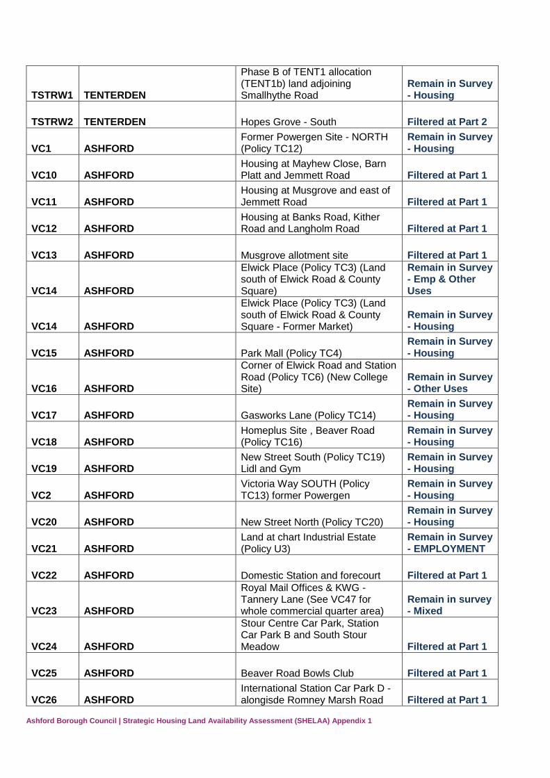
TSTRW1 TENTERDEN
Phase B of TENT1 allocation (TENT1b) land adjoining Smallhythe Road
Remain in Survey - Housing
TSTRW2 TENTERDEN Hopes Grove - South Filtered at Part 2
VC1 ASHFORD Former Powergen Site - NORTH (Policy TC12)
Remain in Survey - Housing
VC10 ASHFORD Housing at Mayhew Close, Barn Platt and Jemmett Road Filtered at Part 1
VC11 ASHFORD Housing at Musgrove and east of Jemmett Road Filtered at Part 1
VC12 ASHFORD Housing at Banks Road, Kither Road and Langholm Road Filtered at Part 1
VC13 ASHFORD Musgrove allotment site Filtered at Part 1
VC14 ASHFORD
Elwick Place (Policy TC3) (Land south of Elwick Road & County Square)
Remain in Survey - Emp & Other Uses
VC14 ASHFORD
Elwick Place (Policy TC3) (Land south of Elwick Road & County Square - Former Market)
Remain in Survey - Housing
VC15 ASHFORD Park Mall (Policy TC4) Remain in Survey - Housing
VC16 ASHFORD
Corner of Elwick Road and Station Road (Policy TC6) (New College Site)
Remain in Survey - Other Uses
VC17 ASHFORD Gasworks Lane (Policy TC14) Remain in Survey - Housing
VC18 ASHFORD Homeplus Site , Beaver Road (Policy TC16)
Remain in Survey - Housing
VC19 ASHFORD New Street South (Policy TC19) Lidl and Gym
Remain in Survey - Housing
VC2 ASHFORD Victoria Way SOUTH (Policy TC13) former Powergen
Remain in Survey - Housing
VC20 ASHFORD New Street North (Policy TC20) Remain in Survey - Housing
VC21 ASHFORD Land at chart Industrial Estate (Policy U3)
Remain in Survey - EMPLOYMENT
VC22 ASHFORD Domestic Station and forecourt Filtered at Part 1
VC23 ASHFORD
Royal Mail Offices & KWG - Tannery Lane (See VC47 for whole commercial quarter area)
Remain in survey - Mixed
VC24 ASHFORD
Stour Centre Car Park, Station Car Park B and South Stour Meadow Filtered at Part 1
VC25 ASHFORD Beaver Road Bowls Club Filtered at Part 1
VC26 ASHFORD International Station Car Park D -alongisde Romney Marsh Road Filtered at Part 1
Page 24
Ashford Borough Council | Strategic Housing Land Availability Assessment (SHELAA) Appendix 1
VC27 ASHFORD DOV Overspill Car Park - E Filtered at Part 1
VC28 ASHFORD Ashford Bowling Alley Filtered at Part 1
VC29 ASHFORD Kent House, Tannery Lane Filtered at Part 1
VC3 ASHFORD land at Victoria Way East (Part of Policy TC11)
Remain in Survey - Housing
VC30 ASHFORD Ashford Bowling Club, Vicarage Lane Filtered at Part 1
VC31 ASHFORD BT Building, Regents Place Filtered at Part 1
VC32 ASHFORD Land around Charter House - Phase 2
Remain in Survey - Housing
VC32 ASHFORD Charter House Change of Use - Phase 1 Filtered at Part 1
VC33 ASHFORD College Court, Vicarage Lane Filtered at Part 1
VC34 ASHFORD
The Phonix PH, Former Ashford Magistrates Court (now Training centre) and Ashford Police Station Filtered at Part 1
VC35 ASHFORD Park Street - Areas of hardstanding and car parking Filtered at Part 1
VC36 ASHFORD RSPCA Cattery and adj buildings, Station Road Filtered at Part 1
VC37 ASHFORD Trafalgar House Filtered at part 1
VC38 ASHFORD Ashford Christian Fellowship, Bank Street Filtered at Part 1
VC39 ASHFORD Ashford School (Various Sites within Town Centre and East Hill) Filtered at Part 1
VC4 ASHFORD (Policy U7) Leacon Road, Ashford Remain in Survey - Housing
VC41 ASHFORD Allotment Land rear of 2-60 William Road Filtered at Part 1
VC42 ASHFORD The Old Bakery, Former Saracens garage, Victoria Crescent Filtered at Part 1
VC43 ASHFORD Queen House, Queen Street Filtered at Part 1
VC44 ASHFORD Ashford Town Bowls Club Filtered at Part 1
VC45 Ashford Unit 1, Chunnel Estate, Victoria Road
Filtered - Employment
VC46 ASHFORD Dover Place Car Park (Part of Commercial Quarter VC47)
Remain in Survey - EMPLOYMENT
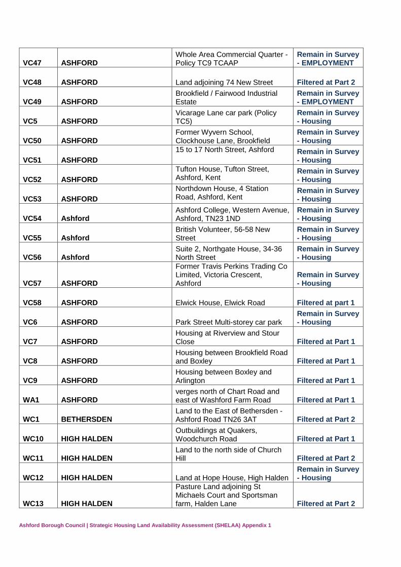
VC47 ASHFORD Whole Area Commercial Quarter - Policy TC9 TCAAP
Remain in Survey - Housing
Page 25
Ashford Borough Council | Strategic Housing Land Availability Assessment (SHELAA) Appendix 1
VC47 ASHFORD Whole Area Commercial Quarter - Policy TC9 TCAAP
Remain in Survey - EMPLOYMENT
VC48 ASHFORD Land adjoining 74 New Street Filtered at Part 2
VC49 ASHFORD Brookfield / Fairwood Industrial Estate
Remain in Survey - EMPLOYMENT
VC5 ASHFORD Vicarage Lane car park (Policy TC5)
Remain in Survey - Housing
VC50 ASHFORD Former Wyvern School, Clockhouse Lane, Brookfield
Remain in Survey - Housing
VC51 ASHFORD
15 to 17 North Street, Ashford Remain in Survey - Housing
VC52 ASHFORD
Tufton House, Tufton Street, Ashford, Kent
Remain in Survey - Housing
VC53 ASHFORD
Northdown House, 4 Station Road, Ashford, Kent
Remain in Survey - Housing
VC54 Ashford Ashford College, Western Avenue, Ashford, TN23 1ND
Remain in Survey - Housing
VC55 Ashford British Volunteer, 56-58 New Street
Remain in Survey - Housing
VC56 Ashford Suite 2, Northgate House, 34-36 North Street
Remain in Survey - Housing
VC57 ASHFORD
Former Travis Perkins Trading Co Limited, Victoria Crescent, Ashford
Remain in Survey - Housing
VC58 ASHFORD Elwick House, Elwick Road Filtered at part 1
VC6 ASHFORD Park Street Multi-storey car park Remain in Survey - Housing
VC7 ASHFORD Housing at Riverview and Stour Close Filtered at Part 1
VC8 ASHFORD Housing between Brookfield Road and Boxley Filtered at Part 1
VC9 ASHFORD Housing between Boxley and Arlington Filtered at Part 1
WA1 ASHFORD verges north of Chart Road and east of Washford Farm Road Filtered at Part 1
WC1 BETHERSDEN Land to the East of Bethersden - Ashford Road TN26 3AT Filtered at Part 2
WC10 HIGH HALDEN Outbuildings at Quakers, Woodchurch Road Filtered at Part 1
WC11 HIGH HALDEN Land to the north side of Church Hill Filtered at Part 2
WC12 HIGH HALDEN Land at Hope House, High Halden Remain in Survey - Housing
WC13 HIGH HALDEN
Pasture Land adjoining St Michaels Court and Sportsman farm, Halden Lane Filtered at Part 2
Page 26
Ashford Borough Council | Strategic Housing Land Availability Assessment (SHELAA) Appendix 1
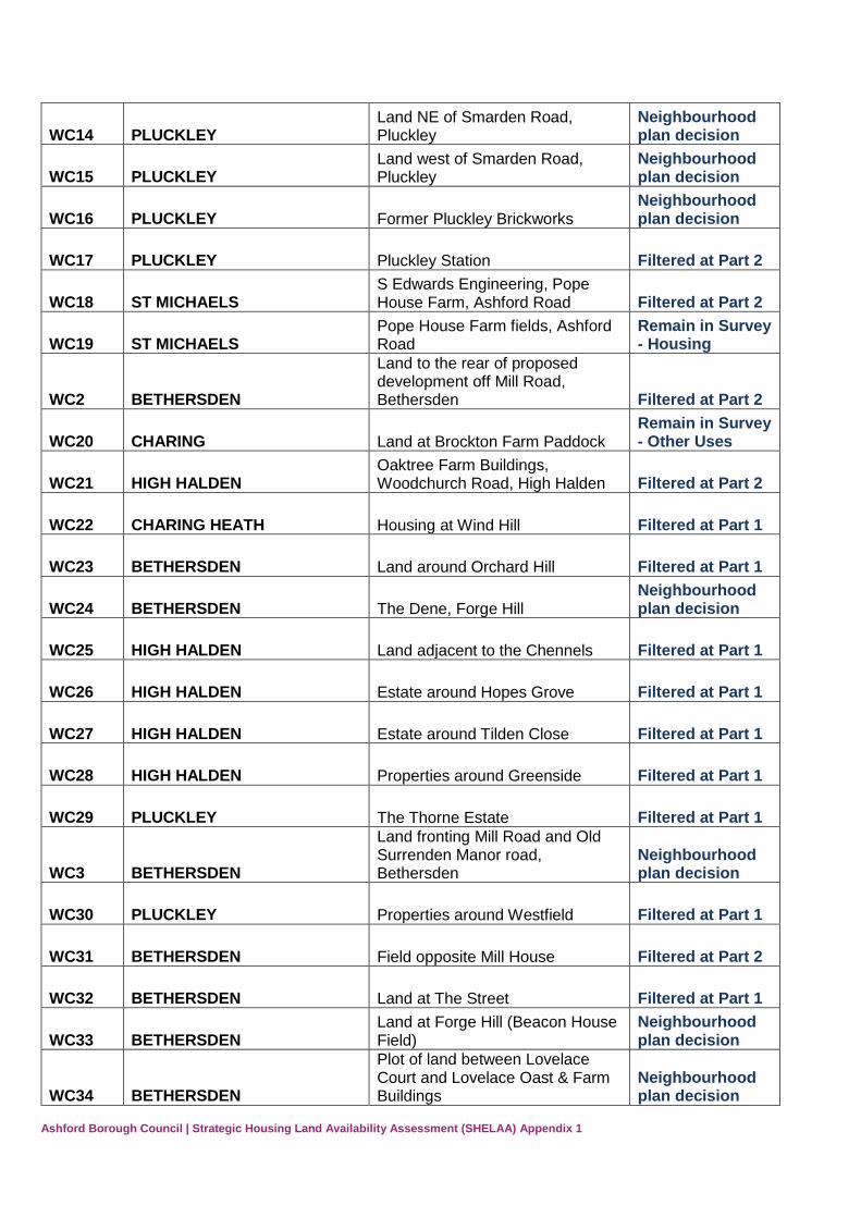
WC14 PLUCKLEY Land NE of Smarden Road, Pluckley
Neighbourhood plan decision
WC15 PLUCKLEY Land west of Smarden Road, Pluckley
Neighbourhood plan decision
WC16 PLUCKLEY Former Pluckley Brickworks Neighbourhood plan decision
WC17 PLUCKLEY Pluckley Station Filtered at Part 2
WC18 ST MICHAELS S Edwards Engineering, Pope House Farm, Ashford Road Filtered at Part 2
WC19 ST MICHAELS Pope House Farm fields, Ashford Road
Remain in Survey - Housing
WC2 BETHERSDEN
Land to the rear of proposed development off Mill Road, Bethersden Filtered at Part 2
WC20 CHARING Land at Brockton Farm Paddock Remain in Survey - Other Uses
WC21 HIGH HALDEN Oaktree Farm Buildings, Woodchurch Road, High Halden Filtered at Part 2
WC22 CHARING HEATH Housing at Wind Hill Filtered at Part 1
WC23 BETHERSDEN Land around Orchard Hill Filtered at Part 1
WC24 BETHERSDEN The Dene, Forge Hill Neighbourhood plan decision
WC25 HIGH HALDEN Land adjacent to the Chennels Filtered at Part 1
WC26 HIGH HALDEN Estate around Hopes Grove Filtered at Part 1
WC27 HIGH HALDEN Estate around Tilden Close Filtered at Part 1
WC28 HIGH HALDEN Properties around Greenside Filtered at Part 1
WC29 PLUCKLEY The Thorne Estate Filtered at Part 1
WC3 BETHERSDEN
Land fronting Mill Road and Old Surrenden Manor road, Bethersden
Neighbourhood plan decision
WC30 PLUCKLEY Properties around Westfield Filtered at Part 1
WC31 BETHERSDEN Field opposite Mill House Filtered at Part 2
WC32 BETHERSDEN Land at The Street Filtered at Part 1
WC33 BETHERSDEN Land at Forge Hill (Beacon House Field)
Neighbourhood plan decision
WC34 BETHERSDEN
Plot of land between Lovelace Court and Lovelace Oast & Farm Buildings
Neighbourhood plan decision
Page 27
Ashford Borough Council | Strategic Housing Land Availability Assessment (SHELAA) Appendix 1
WC35 BETHERSDEN
Land between Batemans Corner and The Poplars, Mill Road (Policy Beth1a) Filtered at Part 1
WC36 BETHERSDEN Stevenson Brothers, Ashford Road Filtered at Part 1
WC37 HIGH HALDEN Linden Garage Remain in Survey - Housing
WC38 BETHERSDEN Agricultural land adjacent to Woodfield House, Pot Kiln Lane Filtered at Part 1
WC39 BETHERSDEN Land at Norton Lane Filtered at Part 1
WC4 BETHERSDEN Land to the north of the A28 off forge Hill, Bethersden
Neighbourhood plan decision
WC40 BETHERSDEN Land rear of Lovelace Court Filtered at Part 1
WC41 BETHERSDEN Land to rear of St Margarets Church, Church Hill Filtered at Part 1
WC42 BETHERSDEN Recreation Ground, Mill Road Filtered at Part 1
WC43 BETHERSDEN Land at Mill Road Filtered at Part 1
WC44 HIGH HALDEN Halden House, Ashford Road Filtered at Part 1
WC45 & WC46 HIGH HALDEN Kent County Council Depot Site
Remain in Survey - Housing
WC47 HIGH HALDEN Land on the North West site, Ashford Road Filtered at Part 1
WC48 HIGH HALDEN Hookstead Lands Filtered at Part 1
WC49 HIGH HALDEN Land north of High Halden Filtered at Part 1
WC5 BETHERSDEN Land at Church Hill Neighbourhood plan decision
WC50 HIGH HALDEN Ransley Farm Project Remain in Survey - Housing
WC51 HIGH HALDEN Land south of Millfield and Tilden Close at, Ashford Road Filtered at Part 1
WC52 HIGH HALDEN Land to the north of Hookstead Filtered at Part 1
WC53 HIGH HALDEN Land at Beale Lands Farmhouse and Ely Place, Shawlands Lane Filtered at Part 1
WC54 HIGH HALDEN Land adjacent to (North of) Beaulieu, Ashford Road Filtered at Part 3
WC55 HIGH HALDEN Precinct 13, Ashford Road Remain in Survey - EMPLOYMENT
WC55 HIGH HALDEN Precinct 13, Ashford Road Remain in Survey - Housing
Page 28
Ashford Borough Council | Strategic Housing Land Availability Assessment (SHELAA) Appendix 1
WC56 HIGH HALDEN Land at Street Farm, Ashford Road Filtered at Part 1
WC57 PLUCKLEY Pluckley Green Filtered at Part 1
WC58 PLUCKLEY Land adjoining Pluckley Recreation Ground Filtered at Part 1
WC59 PLUCKLEY
Along Egerton Road out of Pluckley on site on and around old Hop Pickers Huts Filtered at Part 1
WC6 HIGH HALDEN Lees Paddock, Pot Kiln Lane, High Halden
Remain in Survey - Other Uses
WC60 PLUCKLEY Land surrounding Lillooet, Chambers Green Road Filtered at Part 1
WC61 PLUCKLEY Land adjoining Torbay Cottage Filtered at Part 1
WC62 PLUCKLEY Land adjacent to Little Farm, Smarden Road, Pluckley
Neighbourhood plan decision
WC63 TENTERDEN Land south of A28 Filtered at Part 1
WC64 LITTLE CHART Land adjacent to St Marys Church Little Chart Filtered at Part 1
WC65 HIGH HALDEN 7.5 Acres in Ashford Road Filtered at Part 1
WC66 HIGH HALDEN Green Trees, Redbrook Street Filtered at Part 1
WC67 ST MICHAELS Lotland Farm, Biddenden Road, St Michaels Filtered at Part 1
WC68 BETHERSDEN Land adjacent to Unit 5, Bethersden Business Park Filtered at Part 1
WC69 BETHERSDEN Pear Tree Cottage, Ashford Road Filtered at Part 1
WC7 HIGH HALDEN Tyrol Farm, Plurenden Road Remain in Survey - Other Uses
WC70 BETHERSDEN Vine Hall farm, Bethersden Filtered at Part 1
WC71 CHARING Land adjacent to Yew Tree Farm Filtered at Part 1
WC72 BETHERSDEN Great Chart Golf Course, Bears Lane, Great Chart
Neighbourhood plan decision
WC73 CHARING Land at Charing Heath, Adjoing the Red Lion Public House Filtered at Part 1
WC74 HIGH HALDEN
Land to the east of St Mary's Church, the churcyard and Duxbury Filtered at Part 1
WC75 BETHERSDEN Land adjacent to rear of George Public House (Policy BETH2) Filtered at Part 1
WC76 HIGH HALDEN Pillreed Cottage, Plurenden Road, High Halden
Remain in Survey - Other Uses
Page 29
Ashford Borough Council | Strategic Housing Land Availability Assessment (SHELAA) Appendix 1
WC77 PLUCKLEY Thorne Yard, Pluckley (NP Site Ref 3)
Neighbourhood plan decision
WC78 PLUCKLEY East of Smarden Road, Pluckley (NP ref Site 6)
Neighbourhood plan decision
WC79 PLUCKLEY Lambden Road, Pluckley (NP site ref 7)
Neighbourhood plan decision
WC8 HIGH HALDEN Land to the east of Homestall Farm, Ashford Road, High Halden Filtered at Part 2
WC80 HIGH HALDEN Kent Highwys Depot, Ashford Road, High Halden
Remain in Survey - Housing
WC81 PLUCKLEY Parsonage Cottage, Pluckley (NP site ref 8)
Neighbourhood plan decision
WC82 CHARING Barn north west of Fayre Acre, Church Hill, Charing Filtered at Part 1
WC83 HIGH HALDEN
Land between Ravensdale and Beech House, Ashford Road, St Michaels, Tenterden, Kent Filtered at Part 1
WC84 BETHERSDEN Bethersden Business Centre Remain in Survey - EMPLOYMENT
WC85 ST MICHAELS St Michaels Vicarage Filtered at Part 2
WC87 BETHERSDEN The Beeches and Bailey Fields, Ashford Road
Neighbourhood plan decision
WC88 BETHERSDEN The Old Sawmills, Pluckley Road, Bethersden
Neighbourhood plan decision
WC89 HIGH HALDEN CharmWood, Plurenden Lane, High Halden Filtered at Part 2
WC9 HIGH HALDEN Black Cottage orchard (2 sites) Filtered at Part 2
WC90 PLUCKLEY Adj Little Farm (NP Site Ref 4) Neighbourhood plan decision
WC91 PLUCKLEY Adj Thorne Estate (NP Site Ref 5) Neighbourhood plan decision
WC92 HIGH HALDEN Stevenson Brothers and land to rear, Ashford Road
Remain in Survey - Housing
WC93 HIGH HALDEN Martin Park Filtered at part 2
WE1 MERSHAM Frith Field, Aldington Frith Filtered at Part 2
WE10 MERSHAM
Land at south Stour Apiary/Munday Farm House, Cheesemans green Filtered at Part 3
WE11 SEVINGTON Waterbrook Park Remain in Survey - EMPLOYMENT
WE11 SEVINGTON Waterbrook Park Remain in Survey - Housing
WE12 WILLESBOROUGH/MERSHAM Willesborough Garden Centre, Hythe Road
Remain in Survey - Other Uses
Page 30
Ashford Borough Council | Strategic Housing Land Availability Assessment (SHELAA) Appendix 1
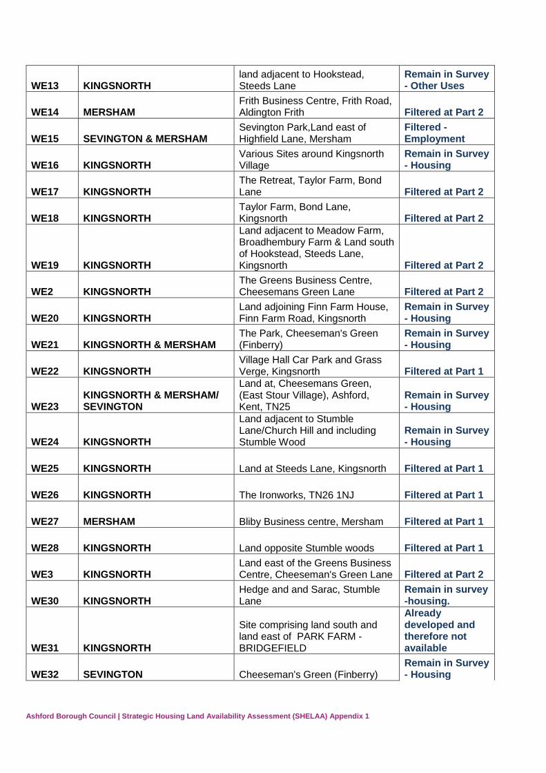
WE13 KINGSNORTH land adjacent to Hookstead, Steeds Lane
Remain in Survey - Other Uses
WE14 MERSHAM Frith Business Centre, Frith Road, Aldington Frith Filtered at Part 2
WE15 SEVINGTON & MERSHAM Sevington Park,Land east of Highfield Lane, Mersham
Filtered - Employment
WE16 KINGSNORTH Various Sites around Kingsnorth Village
Remain in Survey - Housing
WE17 KINGSNORTH The Retreat, Taylor Farm, Bond Lane Filtered at Part 2
WE18 KINGSNORTH Taylor Farm, Bond Lane, Kingsnorth Filtered at Part 2
WE19 KINGSNORTH
Land adjacent to Meadow Farm, Broadhembury Farm & Land south of Hookstead, Steeds Lane, Kingsnorth Filtered at Part 2
WE2 KINGSNORTH The Greens Business Centre, Cheesemans Green Lane Filtered at Part 2
WE20 KINGSNORTH Land adjoining Finn Farm House, Finn Farm Road, Kingsnorth
Remain in Survey - Housing
WE21 KINGSNORTH & MERSHAM The Park, Cheeseman's Green (Finberry)
Remain in Survey - Housing
WE22 KINGSNORTH Village Hall Car Park and Grass Verge, Kingsnorth Filtered at Part 1
WE23 KINGSNORTH & MERSHAM/ SEVINGTON
Land at, Cheesemans Green, (East Stour Village), Ashford, Kent, TN25
Remain in Survey - Housing
WE24 KINGSNORTH
Land adjacent to Stumble Lane/Church Hill and including Stumble Wood
Remain in Survey - Housing
WE25 KINGSNORTH Land at Steeds Lane, Kingsnorth Filtered at Part 1
WE26 KINGSNORTH The Ironworks, TN26 1NJ Filtered at Part 1
WE27 MERSHAM Bliby Business centre, Mersham Filtered at Part 1
WE28 KINGSNORTH Land opposite Stumble woods Filtered at Part 1
WE3 KINGSNORTH Land east of the Greens Business Centre, Cheeseman's Green Lane Filtered at Part 2
WE30 KINGSNORTH Hedge and and Sarac, Stumble Lane
Remain in survey -housing.
WE31 KINGSNORTH
Site comprising land south and land east of PARK FARM - BRIDGEFIELD
Already developed and therefore not available
WE32 SEVINGTON Cheeseman's Green (Finberry) Remain in Survey - Housing
Page 31
Ashford Borough Council | Strategic Housing Land Availability Assessment (SHELAA) Appendix 1
WE34 SEVINGTON Ashford Trade Centre, Hall Avenue Sevington Filtered at Part 1
WE35 KINGSNORTH Homelands Golf Centre Filtered at Part 2
WE36 SEVINGTON Hogben Farm, Sevington Filtered at Part 1
WE37 KINGSNORTH Land at Kiln Farm between Bond Lane and Chuch Hill Filtered at Part 2
WE38 SEVINGTON Sevington (Policy U19) Remain in survey - employment
WE39 MERSHAM Land rear of Village Hall, Church Road
Remain in Survey - Housing
WE4 KINGSNORTH Land at Finn Farm Filtered at Part 3
WE40 MERSHAM Land at Court Lodge Farm, Church Road Filtered at Part 2
WE41 MERSHAM Land at Glebelands, Mersham Filtered at Part 1
WE42 SEVINGTON The Old Rectory, Church Road Filtered at Part 2
WE43 MERSHAM Land north of Bower Farm,Bower Road, Mersham
Remain in Survey - Housing
WE44 SEVINGTON Batts Farm, Rear of Sevington Church
Remain in Survey - Housing
WE45 KINGSNORTH
Land on Church Hill, Kingsnorth (Larger area than WS4 submission) Filtered at Part 2
WE46 KINGSNORTH Kingsnorth Glebe & The Rectory, Church Hill (2 Sites) Filtered at Part 2
WE47 KINGSNORTH Steeds Lane (Land South of Brockman’s Lane, Bridgefield)
Remain in Survey - Housing
WE48 KINGSNORTH Cheesemans Green Lane (South) Filtered at Part 3
WE49 KINGSNORTH Cheesemans Green Lane (North) Filtered at Part 3
WE5 KINGSNORTH Land to the South of Park Farm East
Remain in Survey - Housing
WE50 MERSHAM Swanton (3 sites) Filtered at Part 3
WE51 SEVINGTON Waterbrook Gateway Remain in Survey - Employment
WE52 MERSHAM Bower Farm Filtered at Part 2
WE53 MERSHAM Land at Old Rectory Close Remain in Survey - Housing
WE54 MERSHAM Land on Bower Road Remain in Survey - Housing
Page 32
Ashford Borough Council | Strategic Housing Land Availability Assessment (SHELAA) Appendix 1
WE6 KINGSNORTH Park Farm South East Remain in Survey - Housing
WE7 MERSHAM
Land adjacent 1 Chequer Tree Cottage, Chequer Tree Lane, Mersham Filtered at Part 2
WE8 MERSHAM
Land to the north of Orchard Cottage and Marden, Kingsford Street, Mersham Filtered at Part 2
WE9 MERSHAM Cranwell House, The Forstal Filtered at Part 2
WN1 EGERTON Broad Ham, Rock Hill Road, Egerton Filtered at Part 2
WN10 SMARDEN Properties around the Acorns Filtered at Part 1
WN11 SMARDEN land south of Chessenden Lane, Smarden Filtered at Part 1
WN12 SMARDEN Longwait Title, Vesper Lane, Smarden Filtered at Part 1
WN13 SMARDEN Bethersden Road/Biddenden Road Filtered at Part 1
WN14 EGERTON Land at Egerton Forstal (Address?) Filtered at Part 1
WN15 EGERTON Jegrac, Forstal Road, Egeton Forstal Filtered at Part 1
WN16 SMARDEN Site in Smarden - Address??? Filtered at Part 1
WN17 SMARDEN Site in Smarden - Address??? Filtered at Part 1
WN18 SMARDEN Land on Bethersden Road, adjacent to Ashdown Court Filtered at Part 1
WN19 EGERTON Bramley Farm, Stonebridge Green Road Filtered at Part 1
WN2 EGERTON land to the NE of New Road, Egerton
Remain in Survey - Housing
WN20 SMARDEN land in Smarden (find address details) Filtered at Part 1
WN21 SMARDEN Land adjacent to Buffalo and Fleet Farm Oast Filtered at Part 2
WN22 EGERTON Land adj to Forstal Villas, Egerton Forstal Filtered at Part 2
WN23 SMARDEN Land at Gillets Farm, Water Lane, Smarden Filtered at Part 2
WN3 SMARDEN
Mill Lane, Smarden (Land between Boughton Cottage & Millview Cottage) Filtered at Part 2
WN4 SMARDEN land Adjacent to Smarden Village Hall
Remain in Survey - Housing
WN5 SMARDEN Land adjacent to Long Meadow, Smarden Filtered at Part 2
Page 33
Ashford Borough Council | Strategic Housing Land Availability Assessment (SHELAA) Appendix 1
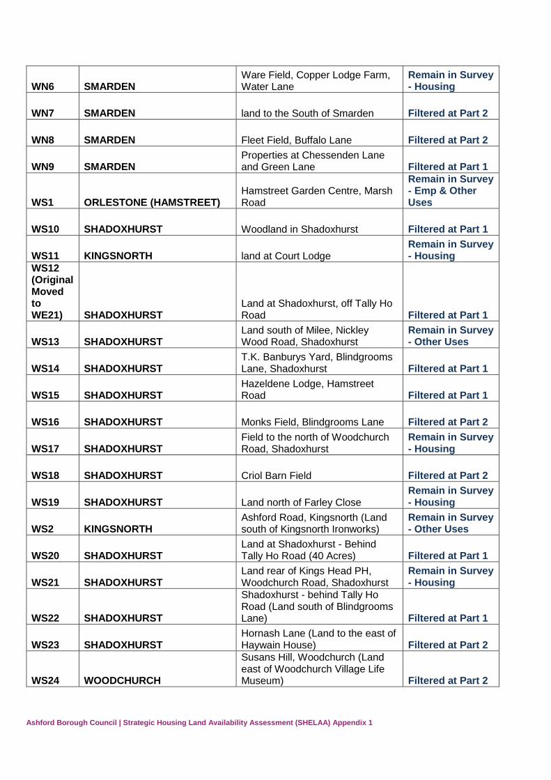
WN6 SMARDEN Ware Field, Copper Lodge Farm, Water Lane
Remain in Survey - Housing
WN7 SMARDEN land to the South of Smarden Filtered at Part 2
WN8 SMARDEN Fleet Field, Buffalo Lane Filtered at Part 2
WN9 SMARDEN Properties at Chessenden Lane and Green Lane Filtered at Part 1
WS1 ORLESTONE (HAMSTREET) Hamstreet Garden Centre, Marsh Road
Remain in Survey - Emp & Other Uses
WS10 SHADOXHURST Woodland in Shadoxhurst Filtered at Part 1
WS11 KINGSNORTH land at Court Lodge Remain in Survey - Housing
WS12 (Original Moved to WE21) SHADOXHURST
Land at Shadoxhurst, off Tally Ho Road Filtered at Part 1
WS13 SHADOXHURST Land south of Milee, Nickley Wood Road, Shadoxhurst
Remain in Survey - Other Uses
WS14 SHADOXHURST T.K. Banburys Yard, Blindgrooms Lane, Shadoxhurst Filtered at Part 1
WS15 SHADOXHURST Hazeldene Lodge, Hamstreet Road Filtered at Part 1
WS16 SHADOXHURST Monks Field, Blindgrooms Lane Filtered at Part 2
WS17 SHADOXHURST Field to the north of Woodchurch Road, Shadoxhurst
Remain in Survey - Housing
WS18 SHADOXHURST Criol Barn Field Filtered at Part 2
WS19 SHADOXHURST Land north of Farley Close Remain in Survey - Housing
WS2 KINGSNORTH Ashford Road, Kingsnorth (Land south of Kingsnorth Ironworks)
Remain in Survey - Other Uses
WS20 SHADOXHURST Land at Shadoxhurst - Behind Tally Ho Road (40 Acres) Filtered at Part 1
WS21 SHADOXHURST Land rear of Kings Head PH, Woodchurch Road, Shadoxhurst
Remain in Survey - Housing
WS22 SHADOXHURST
Shadoxhurst - behind Tally Ho Road (Land south of Blindgrooms Lane) Filtered at Part 1
WS23 SHADOXHURST Hornash Lane (Land to the east of Haywain House) Filtered at Part 2
WS24 WOODCHURCH
Susans Hill, Woodchurch (Land east of Woodchurch Village Life Museum) Filtered at Part 2
Page 34
Ashford Borough Council | Strategic Housing Land Availability Assessment (SHELAA) Appendix 1
WS25 WOODCHURCH Land in Lower Road, Woodchurch (north of The Granary)
Remain in Survey - Housing
WS26 WOODCHURCH Land to the west of Lower Road, Woodchurch (site 2)
Remain in Survey - Housing
WS27 WOODCHURCH Land south of Rectory Close, Woodchurch Filtered at Part 3
WS28a WOODCHURCH Land between 82 and 120 Front Road (POLICY WOOD1)
Remain in Survey - Housing
WS28b WOODCHURCH Larger area of land between 82 and 120 Front Road Filtered at Part 2
WS29 WOODCHURCH Land to the west of Lower Road, Woodchurch (site 1)
Remain in Survey - Housing
WS3 KINGSNORTH Fields behind Halfway Bungalow & Yard, Ashford Road, Kingsnorth Filtered at Part 2
WS30 ORLESTONE (HAMSTREET) Land north of St. Mary's Close, Hamstreet
Remain in Survey - Housing
WS31 WOODCHURCH Harlakenden Farm Buildings, Plurenden Road, Woodchurch Filtered at Part 2
WS32 KINGSNORTH & SHADOXHURST
Land adjacent to Goatley Farm, Ashford Road, Stubbs Cross Filtered at Part 1
WS33 SHADOXHURST
Land adjacent to Bethersden Road and Woodchurch Road, Shadoxhurst
Remain in Survey - Housing
WS34 ORLESTONE (HAMSTREET) Capel Orchard, Capel Road, Orlestone Filtered at Part 1
WS35 ORLESTONE (HAMSTREET) Land adjacent to Mountain Farm, Marsh Road, Hamstreet Filtered at Part 2
WS36 SHADOXHURST Housing around Nairne Close Filtered at Part 1
WS37 ORLESTONE (HAMSTREET) Land and buildings at Parker Farm (POLICY HAM2)
Remain in Survey - Housing
WS38 ORLESTONE (HAMSTREET) Development site off Ashford Road - Rear of Orlestone Villa's Filtered at Part 3
WS38b WAREHORNE
Land at Warehorne Road, Hamstreet (larger area than original submission)
Remain in Survey - Housing
WS39 ORLESTONE (HAMSTREET) Rosehaven, Bourne Lane (PART OF POLICY HAM1)
Remain in Survey - Housing
WS4 KINGSNORTH Briars, Church Hill, Kingsnorth Remain in Survey - Housing
WS40 ORLESTONE (HAMSTREET) Land at Lancaster Close (POLICY HAM1) Filtered at Part 1
WS41 ORLESTONE (HAMSTREET) Land adjacent Orlestone Rise Filtered at Part 1
WS42
WS43 WOODCHURCH Townland Green Filtered at Part 1
Page 35
Ashford Borough Council | Strategic Housing Land Availability Assessment (SHELAA) Appendix 1
WS44 WOODCHURCH Land adjacent HA development at Appledore Road
Remain in Survey - Housing
WS45 WOODCHURCH Land at 126 Front Road Filtered at Part 1
WS46 WOODCHURCH Land on Front Road, north of Surgery Filtered at Part 1
WS47 WOODCHURCH Land on Front Road, south of Surgery Filtered at Part 1
WS48 SHADOXHURST Land on Hamstreet Road, Shadoxhurst Filtered at Part 1
WS49 SHADOXHURST Woodside, Nickley Wood, Shadoxhurst Filtered at Part 1
WS5 SHADOXHURST Whiteholm, Ashford Road Filtered at Part 1
WS50 SHADOXHURST Mill House, Shadoxhurst Filtered at Part 1
WS51 SHADOXHURST Jenky Farm, Church Lane, Shadoxhurst Filtered at Part 1
WS52 WAREHORNE Land rear of Spot Bungalow, Warehorne Filtered at Part 1
WS53 WAREHORNE Brackenlea Filtered at Part 1
WS54 WAREHORNE Land at Warehorne road Filtered at Part 1
WS55 SHADOXHURST Land and Buildings at Clarkswood, Hornash Lane Filtered at Part 1
WS56 SHADOXHURST The Brill, Nickley Wood Road Filtered at Part 1
WS57 SHADOXHURST Shadoxhurst Garage Site, Woodchurch Road
Filterd at part one
WS58 SHADOXHURST Rear of Tally Ho Road, Fronting Blindgrooms Lane Filtered at Part 1
WS59 SHADOXHURST Land fronting Church Lane Filtered at Part 1
WS6 KINGSNORTH Magpie Hall Road, Kingsnorth End (Land to the south of Wainsbrook) Filtered at Part 2
WS60 WOODCHURCH Gladwell Farm Filtered at Part 1
WS61 WOODCHURCH Mayshaves, Woodchurch Filtered at Part 1
WS62 WOODCHURCH King Farm, Woodchurch Filtered at Part 1
WS63 WOODCHURCH
Land next to Shirkoak Caravan Park, Opposite West Lodge, Bethersden Road Filtered at Part 1
WS64 WAREHORNE Viaduct Terrace, Hamstreet Filtered at Part 1
Page 36
Ashford Borough Council | Strategic Housing Land Availability Assessment (SHELAA) Appendix 1
WS69 WOODCHURCH Bournes Field (Land to the north of Bournes Place) Filtered at Part 3
WS7 KINGSNORTH Land south of Magpie Hall Road Filtered at Part 2
WS70 SHADOXHURST Land adjacent to Park Farm Close Filtered at Part 3
WS71 ORLESTONE (HAMSTREET) Land adjacent to Lancaster Close, Cotton Hill Land, Bourne Lane Filtered at Part 2
WS9 WOODCHURCH Land adjacent to Sunny Mead Darm, Bethersden Road Filtered at Part 2
WY1 WYE Wye Court farm, Wye (POLICY WYE1)
Remain in Survey - Housing
WY10 WYE Rams Field Filtered at Part 1
WY11 WYE Oxenturn Road Filtered at Part 1
WY12 WYE Mill House Filtered at Part 1
WY13 WYE Land behind Tickled Trout Public House Filtered at Part 1
WY14 WYE Wye Court Farm, Harville Road Filtered at Part 1
WY15 WYE Land to the rear of Jarmans Field Filtered at Part 1
WY16 WYE Site to the east of Tickled Trout Public House Filtered at Part 1
WY17 WYE Land adjoining The Surgery, Oxenturn Road Filtered at Part 1
WY18 BROOK Naccolt, brook Remain in Survey - Housing
WY19 WYE Wolfson House, Upper Bridge Street
WY20 WYE Goodcheap Farm, Goodcheap lane
WY21 WYE Sidelands, Top Road, Wye
WY22 WYE Land south of brickfield cottages, Harville Road Filtered at Part 1
WY2A WYE Luckley Field, Wye (POLICY WYE2) Filtered at Part 2
WY2B WYE Luckley Field, Wye Remain in Survey - Housing
WY3 WYE (POLICY WYE3) Land at Olantigh Road and Occupation Road
Neighbourhood plan decision
WY4 WYE Housing estate at Little Chequers Filtered at Part 1
WY5 WYE Housing estate at Churchfield Way and Abbots Walk Filtered at Part 1
Page 37
Ashford Borough Council | Strategic Housing Land Availability Assessment (SHELAA) Appendix 1
WY6 WYE 65 Oxenturn Road Filtered at Part 1
WY7 WYE Cobwebs, Harville Road Filtered at Part 1
WY8 WYE Land adjacent Lark Rise, Harville Road Filtered at Part 1
WY9 WYE Former Oil Depot, Bramble Lane Filtered at Part 1