PRESENT ENVIRONMENT AND SUSTAINABLE DEVELOPMENT, VOL. 5, no. 1, 2011 ASPECTS REGARDING THE VARIABILITY OF THE LEVELS OF SIUTGHIOL AND TĂBĂCĂRIE LAKES Camelia-Eliza (Telteu) Păsculescu 1 Key words: lakes, levels, precipitations, evapotranspiration, anthropic factors. Abstract. The present paper presents some issues regarding the variability of Siutghiol and Tăbăcărie lakes levels and some natural and anthropic factors which can influence this variability. The analysis is based on the processing of monthly and yearly levels of Siutghiol Lake (between 1988-2008) and Tăbăcărie Lake (between 1993-2008), taken from the National Institute of Hydrology and Water Management. The analysis regarding the variability of the levels of Siutghiol Lake highlights one interval with low levels (1990) and two years (1997 and 1999) with high levels. In the case of Tăbăcărie Lake, the analysis highlights two years with lower levels (1997 and 2004) and two years with higher levels between the years 2001-2002. The levels with the highest frequency for Siutghiol Lake ranged between 180-199 cm, which represented 28.17%, almost 71 months. In the case of Tăbăcărie Lake, the levels with the highest frequency ranged between 140-159 cm, which represented 44.23%, almost 80 months. The variation of the levels of Siutghiol and Tăbăcărie lakes is the result of the combination between the natural and anthropic factors. So, it is a connection between the mean yearly levels of the Siutghiol Lake and the annual amounts of the precipitations and also, between the mean monthly multiannual levels of the Tăbăcărie Lake and the mean multiannual monthly values of the potential evapotranspiration. The analysis regarding the correlations between the mean monthly levels of Siutghiol and Tăbăcărie lakes highlights a connection between these two lakes only in May. Introduction On the Black Sea shore, southward of Cape Midia, because of the marine abrasion and accumulation, the Siutghiol and Tăbăcărie lakes formed. The Siutghiol Lake stands out because of the depths of over 18 meters, due to the karst phenomena on the bottom of the lake (Gâştescu, 1963) and the Tăbăcărie Lake stands out because of its shores as the most "corrected" and with the form closest of that of the circle (Breier, 1976). The present paper presents some issues regarding the specific features of the levels variation of the Siutghiol and Tăbăcărie lakes and the role of the natural and 1 Stud. PhD., University of Bucharest, Bucureşti, [email protected]
Transcript
PRESENT ENVIRONMENT AND SUSTAINABLE DEVELOPMENT, VOL. 5, no. 1, 2011
ASPECTS REGARDING THE VARIABILITY OF THE LEVELS OF
Abstract. The present paper presents some issues regarding the variability of
Siutghiol and Tăbăcărie lakes levels and some natural and anthropic factors which
can influence this variability. The analysis is based on the processing of monthly and
yearly levels of Siutghiol Lake (between 1988-2008) and Tăbăcărie Lake (between
1993-2008), taken from the National Institute of Hydrology and Water Management.
The analysis regarding the variability of the levels of Siutghiol Lake highlights one
interval with low levels (1990) and two years (1997 and 1999) with high levels. In
the case of Tăbăcărie Lake, the analysis highlights two years with lower levels (1997
and 2004) and two years with higher levels between the years 2001-2002. The levels
with the highest frequency for Siutghiol Lake ranged between 180-199 cm, which
represented 28.17%, almost 71 months. In the case of Tăbăcărie Lake, the levels
with the highest frequency ranged between 140-159 cm, which represented 44.23%,
almost 80 months. The variation of the levels of Siutghiol and Tăbăcărie lakes is the
result of the combination between the natural and anthropic factors. So, it is a
connection between the mean yearly levels of the Siutghiol Lake and the annual
amounts of the precipitations and also, between the mean monthly multiannual
levels of the Tăbăcărie Lake and the mean multiannual monthly values of the
potential evapotranspiration. The analysis regarding the correlations between the
mean monthly levels of Siutghiol and Tăbăcărie lakes highlights a connection
between these two lakes only in May.
Introduction On the Black Sea shore, southward of Cape Midia, because of the marine
abrasion and accumulation, the Siutghiol and Tăbăcărie lakes formed. The
Siutghiol Lake stands out because of the depths of over 18 meters, due to the karst
phenomena on the bottom of the lake (Gâştescu, 1963) and the Tăbăcărie Lake stands out because of its shores as the most "corrected" and with the form closest
of that of the circle (Breier, 1976).
The present paper presents some issues regarding the specific features of the levels variation of the Siutghiol and Tăbăcărie lakes and the role of the natural and
For the analysis of the meteorological factors, we processed the data regarding
the air temperature and the precipitation taken from the website European Climate Assessment&Dataset (between the years 1988–2008). The analysis regarding the
potential evapotranspiration and the snow layer is based on the processing of the data taken from the paper Clima României, 2008 (between the years 1961-2000).
The used methodology includes statistical analysis (realized with the Excel
software), employed to determine the temporary variation of the levels, the frequencies and the duration of the levels, correlations, investigation and
observation made on the field.
Many researchers, as C. Brătescu (1942), A. C. Banu (1961, 1964), P. Gâştescu (1963, 1971), C. Trufaş, V. Trufaş (1972), A. Breier (1976) etc. have
brought important scientific contributions regarding the genesis, the evolution, the
physical and chemical features of the lakes’ water.
1. The main data regarding the Siutghiol and Tăbăcărie lakes Siutghiol Lake is a lagoon bay, crossed by a sand belt 300–400 meters wide
and 9 kilometers long on which Mamaia resort is located (Geografia României,
2005). The main source of supply is represented by the freshwater carst springs of
Caragea-Dermen (Geografia României, 2005). The marine abrasion (the main factor), the tectonics and the lithology (the
secondary factors) determined the shaping of the Siutghiol’s lake basin. The depths
of over 17 meters (tab. 1) have been favored by the presence of the Upper Jurassic-Lower Cretaceous which allowed the dissolution process and the shaping of some
submerged sinkholes (Gâştescu, 1963).
If in the case of the Siutghiol Lake, the marine abrasion represents the main
factor which determined the shaping of the lake basin, in the case of the Tăbăcărie
Lake, the lithology represents the main factor because of the karstical phenomena
(Gâştescu, 1971). This fact is emphasized, also, by its position above the sea level,
almost 125 centimeters, which reflects its genesis and the direction of the
communication with the Black Sea (The National Administration “Romanian
Water” – Headquarter, Bucharest, 2007-2008). The Tăbăcărie Lake underwent many anthropogenic changes, because
between the years 1978-1979 the lake basin was dredged, its shores were rectified,
strengthened and arranged with pedestrian alleys (Caraivan, Secrieru, Fulga, Păun,
2009).
Aspects regarding the variability of the levels of Siutghiol and Tăbăcărie lakes 75
Between the Siutghiol and Tăbăcărie lakes and the Black Sea, some channels
were made, so the excess of the water is discharged into the sea by a weir, located
in a place named „Pescărie” (The National Administration “Romanian Water”–
Headquarter, Bucharest, 2007-2008, observations on the field). The water of the Siutghiol Lake is used in industry, fish farming, irrigation,
entertainment and, through a channel, the lake supplies the Taşaul Lake with
freshwater (The National Administration “Romanian Water”–Headquarters,
Bucharest, 2007-2008). S.E. Ovidiu is the water treatment plant located at north-eastward of the
Ovidiu town, near the Siutghiol Lake. The plant’s capacity is exceeded due to some
works, and the wastewater which enters the plant (at hours of maximum consumption) can not be all pumped through the treatment plant, part of it reaching
through the safety pipeline the Siutghiol Lake (about 3l/s) (The National
Administration “Romanian Water”–Headquarters, Bucharest, 2007-2008).In the Tăbăcărie lake arrives part of the rainwater from the channeling of
Constanţa, from collectors which are provided with overflow tresholds for catching
the wastewater and rainwater and their transportation to the pumping station of
wastewater (The National Administration “Romanian Water”–Headquarters,
Bucharest, 2007-2008).
Tab. 1 - Data regarding the main features of the Siutghiol and Tăbăcărie lakes
Lacustrine area
coefficient
Lake Lake area
f0 (km²)
Catchment area
F (km²)
Depth
h (m)
K=f0/F K=F/f0
Siutghiol 19 71.65 17.05 0.26 3.88
Tăbăcărie 0.98 9.56 3.7 0.10 9.75
Bibliographic sources: Geografia României, 2005; Romanescu, Gh. 2008; Caraivan G., Secrieru, D.,
Fulga, C., Păun, F., 2009.
2. The climatic features – the important factor which influences the hydrological features of the Siutghiol and Tăbăcărie lakes
The climatic features represent the decisive factor regarding the temporary
variation of the levels of Siutghiol and Tăbăcărie lakes. The air temperature
regime, the precipitations regime and the potential evapotranspiration regime, due
to the specific climatic features of the South Dobrogea, have an important role.
In the study area, the mean multiannual air temperature, between the years
1988-2008, was of 12.2°C; at the Constanţa weather station (data source: ECAD). In the summer months, the mean air temperature was of 23.5°C and in the winter
months it was of 1.4°C (fig. 1).
Camelia-Eliza Păsculescu 76
Fig. 1 - The multiannual monthly variability of the air temperature
at the Constanţa weather station (1988-2008)
As far as the precipitations regime is concerned, the mean multiannual amount
was of 439.5 mm at the Constanţa weather station, between the years 1988-2008 (data source ECAD). The analysis regarding the mean annual amount of
precipitation highlights the year 2004 with high precipitations of over 650 mm and
the year 1990 with low precipitations below 250 mm (fig. 2). At the annual scale, the higher amounts of precipitations are specific to
September and November (over 45 mm) and the lower amounts of precipitations
are specific to January and February (below 20 mm) (data source ECAD) (fig. 3).
Fig. 2 - The variability of the mean annual
amounts of precipitations at the Constanţa
weather station (1988-2008) and their linear
trend
Fig. 3 - The variability of the mean
multiannual monthly amounts of
precipitations at the Constanţa weather
station (1988-2008)
A meteorological parameter with decisive role on the temporary variability of
the lakes levels is the potential evapotranspiration, which has at the Constanţa weather station, the mean annual values of 725.6 mm (between the years 1961-
Aspects regarding the variability of the levels of Siutghiol and Tăbăcărie lakes 77
2000). Between June and August, the potential evapotranspiration exceeded 120
mm/month (Clima României, 2008; Păsculescu (Telteu), 2011).
The climatic features of the South Dobrogea and the sea influence leave their
mark on the snow layer, which is present only for a few days (15 mean days, 44
maximum days – Clima României, 2008; Păsculescu, 2011) and has a mean
monthly thickness below 1 cm.
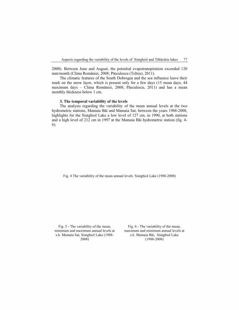
3. The temporal variability of the levels The analysis regarding the variability of the mean annual levels at the two
hydrometric stations, Mamaia Băi and Mamaia Sat, between the years 1988-2008,
highlights for the Siutghiol Lake a low level of 127 cm, in 1990, at both stations and a high level of 212 cm in 1997 at the Mamaia Băi hydrometric station (fig. 4-
6).
Fig. 4 The variability of the mean annual levels Siutghiol Lake (1988-2008)
Fig. 5 - The variability of the mean,
minimum and maximum annual levels at
s.h. Mamaia Sat, Siutghiol Lake (1988-
2008)
Fig. 6 - The variability of the mean,
maximum and minimum annual levels at
s.h. Mamaia Băi, Siutghiol Lake
(1988-2008)
Camelia-Eliza Păsculescu 78
At the multiannual scale, on the Siutghiol Lake, the amplitude of the level
variations (the difference between the maximum and minimum level) recorded the
minimum values of 15 cm, at the Mamaia Băi hydrometric station, and the
minimum values of 16 cm, at the Mamaia Sat hydrometric station, in 1997. The
maximum value of 57 cm was recorded in 1990 at both hydrometric stations (fig.
7).
At the annual scale, the mean multiannual monthly levels (between the years
1988-2008) ranged between 165 cm (in September) and 193 cm (in April) at both hydrometric stations which represents a value of the amplitude of 28 cm.
Fig. 7 - The annual variability of the mean level amplitude Siutghiol Lake (1988-2008)
Fig. 8 - The variability of the mean, minimum and maximum levels at the Tăbăcărie
hydrometric station, Tăbăcărie Lake (1993-2008)
At the multiannual scale, on the Tăbăcărie Lake, the mean amplitude of the
levels variations recorded the minimum value of 19 cm, in the year 2002 and the
maximum value of 61 cm, in the year 1995 (fig. 9). At the annual scale, the mean
multiannual monthly levels (between the years 1993-2008) ranged between 124 cm
Aspects regarding the variability of the levels of Siutghiol and Tăbăcărie lakes 79
(in December) and 140 cm (in August) which represents a value of the amplitude
of 16 cm.
Fig. 9 - The annual variability of the levels amplitude at the Tăbăcărie hydrometric station
Tăbăcărie Lake (1993-2008)
For a more rigorous analysis, the levels frequency and duration were calculated,
at monthly scale. In the case of the Siutghiol Lake, between the years 1988-2008,
the maximum frequency recorded at the Mamaia Sat hydrometric station
corresponds to the levels with values between 180-199 cm, which represented 28.71 %, almost 71 months. At the Mamaia Băi hydrometric station, the maximum
frequency recorded corresponds to the levels with values between 180-190 and
200-219 cm, which represented 27.78%, almost 70 months (fig. 10-11).
Fig. 10 The frequency and the duration of
the mean monthly levels at the Mamaia Sat
hydrometric station, Siutghiol Lake (1988-
2008)
Fig. 11 The frequency and the duration of
the mean monthly levels at the Mamaia Băi
hydrometric station,Siutghiol Lake (1988-
2008)
In the case of the Tăbăcărie Lake, between the years 1993-2008, the
maximum frequency recorded corresponds to the levels with values between 140-
159 cm which represented 41.14%, almost 80 months (fig. 12).
Camelia-Eliza Păsculescu 80
Fig. 12 - The frequency and the duration of the mean monthly levels at the Tăbăcărie
hydrometric station, Tăbăcărie Lake (1993-2005)
The analysis regarding the mean annual variation of the levels at the
Tăbăcărie hydrometric station, Tăbăcărie Lake (1993-2008), highlights the lower levels of 108 cm and 107 cm in 1994 and 2004. Between the years 2001-2002, the
higher levels of 152 cm and even 149 cm (fig. 8) were recorded.
The year 2004 was characterized by the large variations of the lake’s levels: during that year, the water level ranged between 91 cm (7-13 April) and 205 cm
(29 August), with the value of the levels amplitude of 114 cm. This variability of
the water levels can be explained by the variability of the amounts of
precipitations, which recorded values between 0.8 mm (7-13 April 2004; which
represents 34.78% of the total amount of the precipitations of April 2004) and
206.8 mm (28-29 August 2004; which represents 74.78% of total amounts of
precipitations of August 2004).
Correlations have been made between the lakes levels and some
meteorological parameters (the precipitations and the potential evapotranspiration)
for recognition of the factors which can influence the variability of the lakes levels. This way, the correlation between the lakes levels and the annual amounts of
precipitations emphasizes a connection between the variables, at level of
significance α=0.05, in the case of the Siutghiol Lake (1988-2008) and a weak
dependence between the variables in the case of the Tăbăcărie Lake (1993-2008)
(fig. 13-14).
The correlation between the mean multiannual monthly levels and the mean
multiannual monthly values of the potential evapotranspiration highlights a
connection between the variables, at level of significance α=0.05, in the case of the
Aspects regarding the variability of the levels of Siutghiol and Tăbăcărie lakes 81
Tăbăcărie Lake, and a weak dependence between the variables in the case of the
Siutghiol Lake (fig. 15-16).
At annual scale, the correlations between the mean monthly levels of the
lakes and the amounts of the precipitations, in the case of the Siutghiol Lake,
highlights a connection between the variables, at a level of significance α=0.05, in
January. In the case of the Tăbăcărie Lake, the correlations highlight a connection
between the variables in April and November, due to the specific amounts of
precipitations of these months (tab. 2).
Fig. 13 - The correlation between the mean
annual levels of the Siutghiol Lake and the
annual amounts of the precipitations at the
Constanţa weather station (1988-2008)
Fig. 14 - The correlation between the mean
annual levels of the Tăbăcărie Lake and the
annual amounts of the precipitations at the
Constanţa weather station (1993-2008)
Fig. 15 - The correlation between the mean
multiannual monthly levels and the mean
multiannual values of the potential
evapotranspiration at the Constanţa weather
station (1988-2008)
Fig. 16 - The correlation between the mean
multiannual monthly levels and the mean
multiannual values of the potential
evapotranspiration at the Constanţa weather
station (1993-2008)
Camelia-Eliza Păsculescu 82
Tab. 2 - The data regarding the correlation coefficients and the determination coefficients
of the relationships between the mean monthly levels of the Siutghiol and Tăbăcărie Lakes
and the mean monthly amounts of the precipitations at the Constanţa weather station (1988
– 2008)
Relationship Correlation coefficient
(r)
Determination coefficient
(R²)
HsI– PsI 0,43 0,189
HtI– PtI 0,06 0,004
HsII – PsII 0,32 0,104
HtII– PtII 0,03 0,001
HsIII – PsIII 0,28 0,081
HtIII– PtIII 0,04 0,002
HsIV – PsIV 0,12 0,014
HtIV – PtIV 0,48 0,228
HsV – PsV 0,01 0,001
HtV – PtV 0,22 0,048
HsVI – PsVI 0,0009 0,0000008
HtVI – PtVI 0,08 0,006
HsVII – PsVII 0,39 0,156
HtVII– PtVII 0,03 0,001
HsVIII – PsVIII 0,4 0,162
HtVIII– PtVIII 0,24 0,057
HsIX– PsIX 0,13 0,018
HtIX – PtIX 0,32 0,101
HsX – PsX 0,07 0,005
HtX– PtX 0,01 0,00007
HsXI – PsXI 0,14 0,021
HtXI– PtXI 0,46 0,209
HsXII – PsXII 0,32 0,105
HtXII– PtXII 0,03 0,0008
Data source: INHGA, ECAD
HsI-HsXII – the mean levels of the January–December, Siutghiol Lake (1988-2008); HtI–
HtXII – the mean levels of January–December, Tăbăcărie Lake (1993-2008); PsI–PsXII – the
amounts of precipitations of January-December, at the Constanţa weather station (1988-2008), PtI–
PtXII – the amounts of precipitations of January-December, at the Constanţa weather station (1993-
2008).
The analysis continues with the correlation between the mean annual levels
of the Siutghiol and Tăbăcărie lakes due to the channel between these two lakes. After the correlation, a weak dependence between variables was highlighted, at a
Aspects regarding the variability of the levels of Siutghiol and Tăbăcărie lakes 83
level of significance α=0.05 (fig. 17). At the annual scale, after the correlations, a
close relationship between the levels of the studied lakes was established only in
May (figure 18) (tab. 3).
Fig. 17 - The correlation between the mean
annual levels of the Siutghiol and Tăbăcărie
lakes (1993-2008
Fig. 18 - The correlation between the mean
monthly levels of the Siutghiol and
Tăbăcărie lakes (1993-2008) (May
Tab. 3 - Data regarding the correlation coefficients and the determination coefficients of the
relationships between the mean monthly levels of the
Siutghiol and Tăbăcărie lakes (1993 – 2008)
Relationship Correlation Coefficient (r)
Determination
coefficient
(R²)
HsI-HtI 0,23 0,054
HsII-HtII 0,03 0,00074
HsIII-HtIII 0,34 0,114
HsIV-HtIV 0,39 0,149
HsV-HtV 0,43 0,185
HsVI-HtVI 0,1 0,011
HsVII-HtVII 0,16 0,026
HsVIII-HtIII 0,14 0,02
HsIX-HtIX 0,11 0,012
HsX-HtX 0,02 0,0004
HsXI-HtXI 0,1 0,01
HsXII-HtXII 0,15 0,02 Data source: INHGA, ECAD
HsI–HsXII – the mean levels from January till December, Siutghiol Lake; HtI–HtXII – the mean monthly levels from January till December, Tăbăcărie Lake;
Camelia-Eliza Păsculescu 84
Fig. 19 - The channel between Siutghiol
Lake–Tăbăcărie Lake
Fig. 20 - The channel between the Tăbăcărie
Lake–The Black Sea
Conclusions The evolution of the Siutghiol and Tăbăcărie lakes is the result of the
combination between the natural and the anthropic factors. Of the natural factors,
the climatic factors have a decisive role. There is a connection between the mean
annual levels of the Siutghiol Lake and the annual amounts of precipitations. Also,
there is a connection between the mean multiannual monthly levels of the Tăbăcărie Lake and the mean multiannual monthly values of the potential
evapotranspiration. Because of the channel between Siutghiol and Tăbăcărie lakes
and the Black Sea correlations between the mean monthly levels of the lakes were
made. Hence, we noticed that only in May there is a close relationship between the
mean monthly levels of the lakes.
Acknowledgments Invest in human resources! This work was supported by project:
POSDRU/88/1.5/S/61150 “Doctoral Studies in the field of life and earth sciences”,
project co-financed through Sectorial Operational Program for the Development of Human Resources 2007-2013 from European Social Fund.
References: Banu, A.C. (1961), Observaţii şi măsurători asupra oscilaţiilor de nivel actuale şi seculare
ale Mării Negre la ţărmul românesc, Hidrobiologia, vol. II, Bucureşti.
Banu, A.C. (1964), Date asupra unei transgresiuni de vârstă istorică în bazinul Mării
Negre şi al Dunării inferioare, Hidrobiologia, vol. V, Bucureşti.
Brătescu, C. (1942), Oscilaţiile de nivel al apelor şi bazinul Mării Negre în cuaternar,
Bul. Soc. Reg. De Geogr., LXI, Bucureşti.
Breier, Ariadna (1976), Lacurile de pe ţărmul românesc al Mării Negre. Studiu
hidrogeografic, Edit. Academiei, Bucureşti.
Aspects regarding the variability of the levels of Siutghiol and Tăbăcărie lakes 85
Caraivan G., Secrieru, D., Fulga, Constantina, Păun, F. (2009), Lacul Tăbăcărie –
Model de poluare urbană, Sesiunea de Comunicări Ştiinţifice GeoEcoMar,
Gâştescu, P. (1963), Lacurile din Republica Populară România. Geneză şi regim
hidrologic, Editura Academiei R.P.R, Bucureşti.
Gâştescu, P. (1971), Lacurile din România – limnologie regională, Editura Academiei
R.S.R., Bucureşti.
Păsculescu (Telteu), Camelia Eliza (2011), Consideration regarding the mean runoff of the main rivers from the South Dobrogea, Aerul şi Apa – Componente ale mediului,
ediţia a III-a, Cluj Napoca.
Romanescu, Gh. (2008), The ecological characteristics of the romanian littoral lakes – the
sector Midia Cape – Vama Veche, Lakes, reservoirs and ponds, Romanian Journal
of Limnology, vol. 1-2, Editura Transversal, Târgovişte.
Trufaş, Constanţa, Trufaş, V., (1972), Transparenţa şi culoarea apei lacurilor din
Dobrogea, Studii şi Cercetări de Geografie Aplicată a Dobrogei, Constanţa.
and Relationship in the Carpathians’Curvature Region (Romania), Geogr. Fis.
Dinam. Quat., 32.
*** (2005), Geografia României-vol. V, Câmpia Română, Dunărea, Podişul Dobrogei, Litoralul Românesc al Mării Negre şi Platforma Continentală, Editura Academiei