Assessing Galileo Positioning Using a Smartphone in an Airborne Platform Américo Magalhãe a , José Alberto Gonçalves a,b and Luísa Bastos a,b a Faculty of Sciences, University of Porto, Porto, Portugal b CIIMAR, University of Porto, Porto, Portugal Abstract GNSS positioning and navigation capabilities using smartphones have seen a great development in recent years, allowing today a level of accuracy that was only achieved before using standard GNSS receivers. This is possible due to the fact that modern smartphones allow access to raw GNSS code and carrier-phase measurements, in particular to the Galileo and GPS multi-frequency signals. This work presents results related with the performance of a Galileo enabled smartphone used in an aerial environment. The Xiaomi Mi8 smartphone, capable of recording dual frequency Galileo and GPS measurements, was mounted in an aircraft used in the scope of the aerial campaigns realized in the frame of the GRC-MS project (Galileo Reference Center - Member States). A Septentrio geodetic receiver, centimeter capabilities, was also installed in the aircraft to be used as reference in the comparison. Galileo-only, GPS-only and Galileo+GPS smartphone solutions, were computed using code and carrier-phase measurements in differential, as well as in standalone modes. Results show that, even with the non-optimal conditions for smartphone signal acquisition in these campaigns, the Galileo-only solutions reached the sub-meter level for the horizontal component and the combined Galileo+ GPS was at the sub-meter level, both in the horizontal and vertical components. Keywords 1 Smartphone, Galileo, raw phase measurements, airborne 1. Introduction Terrestrial navigation with GNSS enabled smartphones has definitely entered in everyday life of the common citizen around the world. Code based positioning is the core of the navigation applications that support many smartphone´s Apps. The introduction on the market, in 2016, of a new generation of smartphones allowing the users to access not only the pseudo-ranges, but also the Doppler and carrier- phase measurements, opened new prospects for PNT (Positioning, Navigation and Timing) based applications. As already demonstrated by several authors, (Elmezayen & El-Rabbany, [1]; Paziewski, Marco Fortunato, Mazzoni & Odolinski, [2]; Critchley-Marrows, Fortunato & Roberts, [3]; Uradziński & Bakuła [4] and Heßelbarth & Wanninger [5]) these paved the way for the achievement of centimeter level accuracy in static positioning, which, until then, could only be achieved with the more expensive and high performance GNSS geodetic receivers. In its “White Paper on using GNSS Raw Measurements on Android devices” [6], the European GNSS Agency (GSA), responsible for promoting the use of the Galileo system, and also the exploitation of the smartphones potential for high accuracy positioning for the mass market applications, showed that a single frequency smartphone, with access to raw data, allows the user to achieve accuracies at the few decimeters level. In fact, results of 0.90 m and 0.62 m, respectively, for the horizontal and vertical ICL-GNSS 2021 WiP Proceedings, June 01–03, 2021, Tampere, Finland EMAIL: [email protected] (A. Magalhães); [email protected] (JA. Gonçalves); [email protected] (L. Bastos) ORCID: 0000-0002-5767-7077 (A. Magalhães); 0000-0001-9212-4649 (JA. Gonçalves); 0000-0001-7464-3568 (L. Bastos) 2021 Copyright for this paper by its authors. Use permitted under Creative Commons License Attribution 4.0 International (CC BY 4.0). CEUR Workshop Proceedings (CEUR-WS.org) Proceedings
Transcript
Assessing Galileo Positioning Using a Smartphone in an Airborne Platform
Américo Magalhãea, José Alberto Gonçalvesa,b and Luísa Bastosa,b
a Faculty of Sciences, University of Porto, Porto, Portugal b CIIMAR, University of Porto, Porto, Portugal
Abstract GNSS positioning and navigation capabilities using smartphones have seen a great
development in recent years, allowing today a level of accuracy that was only achieved before
using standard GNSS receivers. This is possible due to the fact that modern smartphones allow
access to raw GNSS code and carrier-phase measurements, in particular to the Galileo and GPS
multi-frequency signals.
This work presents results related with the performance of a Galileo enabled smartphone used
in an aerial environment. The Xiaomi Mi8 smartphone, capable of recording dual frequency
Galileo and GPS measurements, was mounted in an aircraft used in the scope of the aerial
campaigns realized in the frame of the GRC-MS project (Galileo Reference Center - Member
States). A Septentrio geodetic receiver, centimeter capabilities, was also installed in the aircraft
to be used as reference in the comparison. Galileo-only, GPS-only and Galileo+GPS
smartphone solutions, were computed using code and carrier-phase measurements in
differential, as well as in standalone modes. Results show that, even with the non-optimal
conditions for smartphone signal acquisition in these campaigns, the Galileo-only solutions
reached the sub-meter level for the horizontal component and the combined Galileo+ GPS was
at the sub-meter level, both in the horizontal and vertical components.
Keywords 1 Smartphone, Galileo, raw phase measurements, airborne
1. Introduction
Terrestrial navigation with GNSS enabled smartphones has definitely entered in everyday life of the
common citizen around the world. Code based positioning is the core of the navigation applications that
support many smartphone´s Apps. The introduction on the market, in 2016, of a new generation of
smartphones allowing the users to access not only the pseudo-ranges, but also the Doppler and carrier-
phase measurements, opened new prospects for PNT (Positioning, Navigation and Timing) based
applications. As already demonstrated by several authors, (Elmezayen & El-Rabbany, [1]; Paziewski,
In the aircraft, a multi-frequency PolaRx5 Septentrio receiver [8], with a dedicated multi-frequency
AeroAntenna, which allows the acquisition of multi-constellation, multi-frequency signals (L1, L2, L5,
E1, E5a, E5b, E6, G1, G2, B1, B2, B3) from all GNSS systems available today, was also mounted for
the purposes of the GRC_MS project. The Xiaomi antenna located in the upper left corner of the
smartphone´s screen was aligned with the Septentrio antenna by the fuselage rivets and the leverarm
was obtained using a tape. To refer the smartphone and Septentrio coordinates to the same reference
point the following values were used: x=1.10 m; y=0.00 m; z=0.30 m, as shown in Figure 2.
Figure 2: Leverarm between smartphone antenna and the AeroAntenna
The GNSS raw data from the Mi8 was collected using the Geo++ RINEX Logger App at 1 Hz [9],
which generates files in RINEX format 3.03. The Septentrio receiver was also set to collect data at 1
Hz. The data analyzed in this work was collected in two of the GRC-MS aero campaigns, whose
trajectories are shown in Figure 3. One campaign took place in October 7, 2019 and the other in June
10, 2020. For the relative positioning a permanent reference station, equipped with a multi-frequency
Trimble Alloy receiver and a Zephyr GNSS Geodetic II antenna, located at the AOUP (Astronomical
Observatory of the University of Porto) facilities was used. Coordinates were computed in the
ITRF2014 frame at the observations epoch.
Figure 3: Trajectories followed during the two GRC-MS aero campaigns used in this analysis
3. Data analysis and processing results
PVT (Position, Velocity and Time) solutions were calculated in post-processing using the RTKLIB
Demo5 [10] software, based on the RTKLIB [11]. Double frequency (DF) differential solutions, for
Galileo-only, GPS-only and Galileo+GPS combined observations, were obtained using code and
carrier-phase measurements.
Figure 4 shows the Galileo and GPS skyplots during the two campaigns.
a) b)
Figure 4: Skyplot for October 2019 (a) and June 2020 (b) campaigns. E stands for Galileo satellites and G for GPS satellites
The SNR (Signal-Noise-Ratio) of the Galileo E1/E5a and the GPS L1/L5 signals, acquired by the
Xiaomi Mi8 smartphone and the Septentrio PolaRx5 receiver are shown in figure 5 only for some of
the satellites in order to facilitate the readability. Two low and two high Galileo and GPS satellites were
chosen. As we can see from the skyplot in figure 4, the low satellites shown for the October 2019
campaign were the E07 and G09 and for the June 2020 campaign the E04 and the G32. The high
satellites shown were the E27 and G30 for October 2019 campaign and the E25 and G08, for June 2020
campaign.
Figure 5: SNR for the Xiaomi Mi8 smartphone (left) and the Septentrio PolaRx5 (right) measurements for two Galileo and two GPS satellites for the E1/L1 and E5a/L5 bands
As expected, the SNR from the Mi8 is lower than that of the PolaRx5, due to the limitations of the
Planar Inverted-F Antenna (PIFA) type of antenna. The lower SNR is most noticed for the E5a/L5
signals. Due to the airplane maneuvers the signal from the low satellite G32 shows significant
oscillations for the PolaRx5. This is not seen in the Mi8 signals, because the Mi8 loses more times the
signals and therefore those spikes are no present. As, due to some constrains, the smartphone was
positioned in a less adequate location (inside the rear window of the aircraft), this can be an additional
reason for the attenuation of the signals.
Having in mind the assessment of the smartphone solutions for classical aerial navigation, SPP
solutions for the full flight trajectories were computed. For assessing the ability of the smartphone for
geodetic navigation some profiles were selected in each aerial campaign. Unfortunately, the flight
maneuvers caused a lot of signal loss and a good differential solution was not always possible.
Therefore, our analysis has been restricted to a few profiles.
Four flight profiles (discarding maneuvers parts) were chosen in the two campaigns to compute
kinematic differential solutions. Three of these profiles were flown during the October 2019 campaign
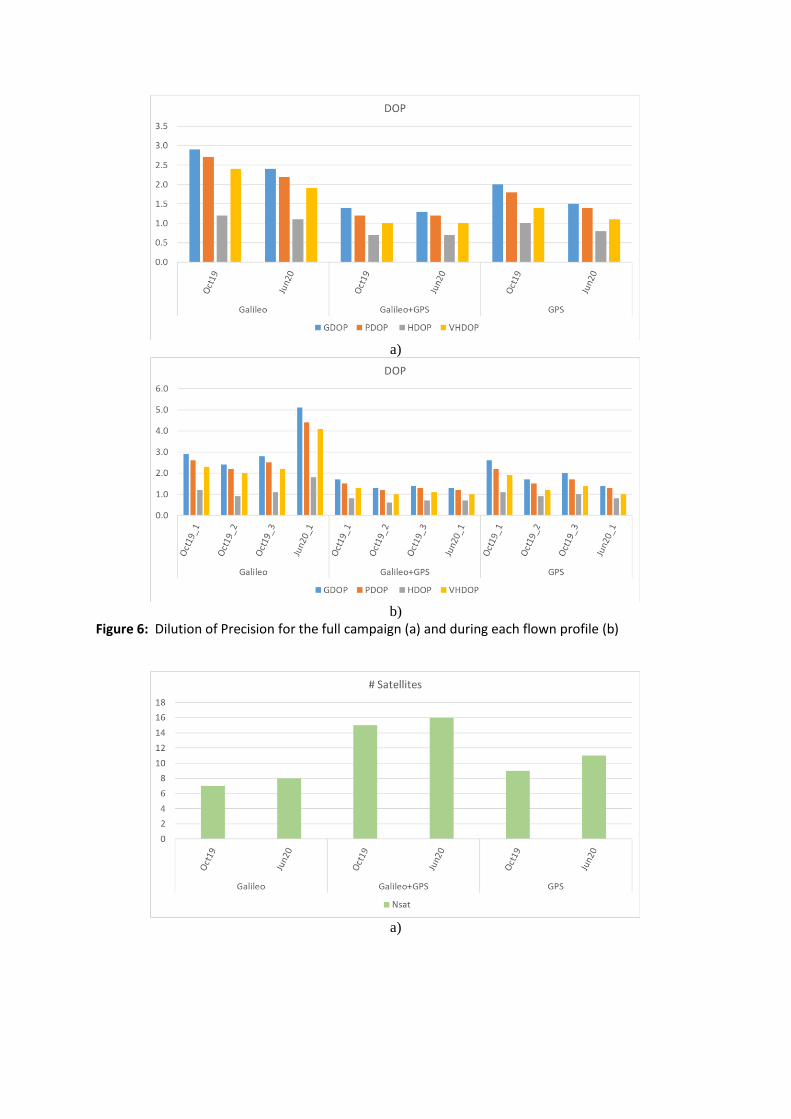
and one during the June 2020 campaign. Figures 6 and 7 show the average DOP (Dilution of Precision)
and number of satellites for each profile analyzed.
a)
b)
Figure 6: Dilution of Precision for the full campaign (a) and during each flown profile (b)
a)
b)
Figure 7: Average number of satellites for the full campaign (a) and during each flown profile (b)
Absolute single frequency SPP (Single Point Positioning) code solutions were also computed using
the E1E5a/L1L5 frequencies from Galileo/GPS and broadcast ephemerides. A 10º elevation mask was
considered and the Klobuchar [12] model was used in the Galileo and GPS solutions for ionosphere
corrections, as well as the Saastamoinen [13] model for the tropospheric corrections.
For the reference trajectory differential triple frequency (TF) solutions, obtained with the combined
Galileo+GPS measurements from the Septentrio PolaRx5 receiver, using the E1/L1, E5a/L5 and
E5b/L2 frequencies, were computed using RTKLIB with the same settings referred above. Over the all
GRC campaigns, the solutions precision obtained with the PolaRx5 receiver when compared with
independent GNSS/IMU and GPS/GLONASS PPP has shown values of less than 5 cm in the horizontal
component for 95% of the times, while the vertical component values vary between 13 -25 cm.
Figures 8 and 9 show the statistics for the dual frequency (DF) differential solutions and the SPP
(Single Point Positioning) solutions. The standard , mean and 95% confidence interval, obtained from
the comparison between the Mi8 smartphone solutions and the Septentrio PolaRx5 Galileo+GPS triple
frequency (E1/l1, E5a/L5, E5b/L2) solutions, used as reference, are shown.
Figure 8 shows the statistics for the differential solutions.