+ All Categories
Home > Documents > ASSESSING THE EFFECTS OF URBAN PLANNING ON RESIDENTIAL PROPERTY

ASSESSING THE EFFECTS OF URBAN PLANNING ON RESIDENTIAL PROPERTY

Date post: 03-Feb-2022
Category:
Upload: others
View: 2 times
Download: 0 times
Share this document with a friend
20
European Scientific Journal May edition vol. 8, No.11 ISSN: 1857 7881 (Print) e - ISSN 1857- 7431 195 ASSESSING THE EFFECTS OF URBAN PLANNING ON RESIDENTIAL PROPERTY VALUES IN AGEGE, LAGOS Ajibola, M. O. Department of Estate Management,School of Environmental Sciences, College of Science and Technology,Covenant University, Ota Nigeria Olaniyan-Adekola, M. Department of Estate Management, School of Environmental Sciences, College of Science and Technology, Covenant University, Ota Nigeria Simon, R. F. Department of Estate Management,School of Environmental Sciences, College of Science and Technology,Covenant University, Ota Nigeria Abstract In urban centres the essence of land use planning is to ensure that urban activities are organised and developed in physical space with due consideration for protection of public interest which include health, safety, convenience, efficiency, energy conservation, environmental quality, social equity, social choice and amenity. With this background, the study examined the effects of land use planning on residential property values using a comparison of two neighbourhoods in Agege Local Government Council Area of Lagos Metropolis. Two groups of respondents were used for the study; the Estate Surveyors and Valuers (29) and residents of New Oko-Oba GRA (120) and Orile Agege (140). Both descriptive and inferential statistical tools were used in analysing the data collected through the questionnaire administered on the respondents. The study revealed that there is significant level of difference in residential property values between the planned and unplanned residential areas. It further revealed that there is a statistically significant relationship between land use planning and property values. The study therefore recommends that government should ensure proper land use planning, while the people
Transcript

European Scientific Journal May edition vol. 8, No.11 ISSN: 1857 – 7881 (Print) e - ISSN 1857- 7431

195

ASSESSING THE EFFECTS OF URBAN PLANNING ON

RESIDENTIAL PROPERTY VALUES IN AGEGE, LAGOS

Ajibola, M. O.

Department of Estate Management,School of Environmental Sciences,

College of Science and Technology,Covenant University, Ota Nigeria

Olaniyan-Adekola, M.

Department of Estate Management, School of Environmental Sciences, College of Science and Technology,

Covenant University, Ota Nigeria

Simon, R. F.

Department of Estate Management,School of Environmental Sciences,

College of Science and Technology,Covenant University, Ota Nigeria

Abstract

In urban centres the essence of land use planning is to ensure that urban activities are

organised and developed in physical space with due consideration for protection of public

interest which include health, safety, convenience, efficiency, energy conservation,

environmental quality, social equity, social choice and amenity. With this background, the

study examined the effects of land use planning on residential property values using a

comparison of two neighbourhoods in Agege Local Government Council Area of Lagos

Metropolis. Two groups of respondents were used for the study; the Estate Surveyors and

Valuers (29) and residents of New Oko-Oba GRA (120) and Orile Agege (140). Both

descriptive and inferential statistical tools were used in analysing the data collected

through the questionnaire administered on the respondents. The study revealed that there

is significant level of difference in residential property values between the planned and

unplanned residential areas. It further revealed that there is a statistically significant

relationship between land use planning and property values. The study therefore

recommends that government should ensure proper land use planning, while the people

European Scientific Journal May edition vol. 8, No.11 ISSN: 1857 – 7881 (Print) e - ISSN 1857- 7431

196

should be made to comply with such regulations. Necessary infrastructure should be

provided to make conducive living, in the unplanned neighbourhoods possible.

Keywords: Lagos, Land Use, Property, Rental Values, Urban Area

Introduction

According to Wikipedia (2011) the Canadian Institute of Planners (2011) , defines

land use planning as the scientific, aesthetic, and orderly disposition of land use resources,

facilities and services with a view to securing the physical, economical , social efficiency,

health and wellbeing of urban and rural communities. Land use or physical planning has

also been described as a process aimed at achieving orderly physical development with the

overall aim of evolving a functional and liveable environment where individual and

common goals can be achieved (Adeagbo 1998). The American Planning Association

(2011) states that the goal of land-use planning is to further the welfare of people and their

communities by creating convenient, equitable, healthful, efficient, and attractive

environments for present and future generations.

Nigeria with her numerous planning agencies both at federal and state levels has a

number of planned residential land uses nevertheless there seemed to be a wide gap

between the planned and unplanned or non-adherence to formal land use planning. What

is on ground physically has not shown government enthusiasm about land use planning.

Though land use planning is a service that provides a scheme to be used for physical

development of a proposed neighbourhood, it does not necessarily result directly into a

good(s), it is however, judged by its product that is, the outcome of its implementation

(Jiriko 1998). The overall success of planning is measured by the attractiveness of the

neighbourhood to land users which in turn impacts on the value of the properties therein.

It is important to examine the effectiveness of land use planning in relation to

property values to establish the effects that adherence to land use planning has on

residential property (rental) values. This study therefore examined the relationship

between urban planning and residential property values in some selected neighbourhoods

within Agege Local Government Council Area of Lagos metropolis.

Study Area:

European Scientific Journal May edition vol. 8, No.11 ISSN: 1857 – 7881 (Print) e - ISSN 1857- 7431

197

Agege Local Government Council Area is one of the sixteen (16) Local

Government Council Areas in Lagos metropolis and it has a land mass of about eighteen

square kilometres (18km2). It is bounded on the north by Ifako/Ijaiye Local Government

Area, on the west by Alimosho Local Government Area and on the east and south by Ikeja

Local Government Area (see fig. 1). Agege, as a community, is older than the

administrative unit known as Agege Local Government Area as it has existed since the

seventeenth century by Awori Yoruba, whose dispersal point was at Isheri-Olofin. It was

from there that some elements moved to Orile-Agege, the original homestead of Agege

community. However, according to oral history, by the end of the nineteenth century,

another settlement emerged near the railway station along the Lagos/Abeokuta rail line.

However, the newer settlement took advantage of its strategic location to draw a steady

influx of migrants and settlers till it became a much bigger community than the original

homestead. As commercial opportunities around the railway station expanded, the

settlement extended to and incorporated Orile-Agege itself. The new Agege that emerged

has thus evolved its own political and administrative institutions with New Oko-Oba

GRAs and some Estates as part of that structure.

Agege as a whole was predominantly designed as a commercial centre but

with passage of time most of the original settlers (mostly traders) finally turn the

area as a home base activity enclave. Similarly, New Oko-Oba GRA was majorly

used for agricultural purposes but was later redesigned into residential area now

known as Oko-Oba residential schemes I-VI. The redesigning of the area has further

brought the government imputes in the provision of some basic amenities which has

enhanced the liveable environment of the place compared to other areas in the

neighbourhood.

European Scientific Journal May edition vol. 8, No.11 ISSN: 1857 – 7881 (Print) e - ISSN 1857- 7431

198

Fig. 1: Map of Lagos Metropolis

Source: Bohr (2006) Barata and Silva (2006)

Literature Review

The concept of planning can be traced down to creation as some reaffirmed that

God Himself was the first planner and the progenitor of zoning concept. Irrespective of

His enormous powers He planned and implemented the creation of the earth in six days. In

His planned process, He employed the concept of zoning various land uses in creation;

land separated from water, birds in the Air, water animals and land animals. Indeed the

story of creation exemplified the planning and zoning concepts. Town and country

planning according to Keeble (1969), is ‘the art and science of ordering the use of land

and citing of buildings and communication routes so as to secure the maximum practicable

degree of economy, convenience, and beauty’ and as ‘an attempt to formulate the

principles that should guide us in creating a civilized physical background for human life’

whose main impetus is thus’ foreseeing and guiding change’. Town planning aims at

securing a sensible and acceptable blend of conservation and exploitation of land, as the

background or stage for human activity.

In Nigeria for instance, town planning is interpreted in section 18 of TOPREC

(Town Planners Registration Council) Decree No. 3 of 1988, as the theory and practise of

town and country planning by the ordering and control of the citing and erection of

buildings and other structures and the provision of open spaces and such similar use of

European Scientific Journal May edition vol. 8, No.11 ISSN: 1857 – 7881 (Print) e - ISSN 1857- 7431

199

land, as the case may be, for the improvement of the human environment. Essentially,

town planning is concerned with the spatial ordering of land use both in the urban and

rural settings for the purpose of creating functionally efficient and aesthetically pleasing

environment for living, working, circulation and recreation. Through town planning, the

physical space is organised and managed in such a way that the environment created today

will meet the demands of tomorrow (i. e sustainable development), satisfy the pluralistic

values and attendant needs of identified groups of people, that all activities arising from

needs (individually or collectively) expressed co-exist in harmony and investments,

conveniences, functionality, living and working within the environment are maximized.

Cheshire and Sheppard (2001) were of the opinion that land use planning serves a

variety of purposes: control of the spatial structure of residential development can reduce

the cost of providing some local public goods and serve to isolate land uses which are

likely to generate costly external effects; regulation of building types; regulation of land

use can be a method of providing valued public goods and amenities such as planned

neighbourhood and open space respectively. They further stated that Land use planning

produces a variety of local amenities and regulates industrial land use and separates it

from residential land use.

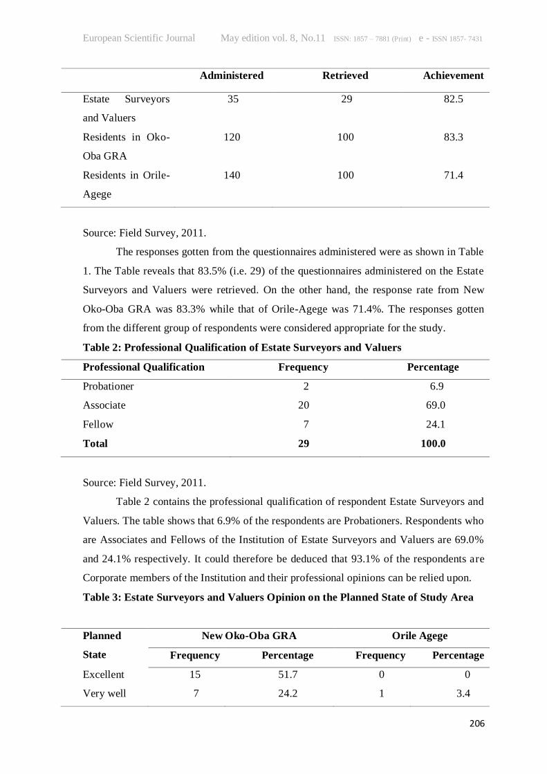
A Review of Some Planning Efforts in Lagos

Concerted efforts have been made in time past by the government and individual

or corporate entity to improve the physical environmental condition of Lagos. Such efforts

include the Lagos Central Planning Scheme (LCPS of 1951) involve the re-housing of

about 200,000 persons over a period of 5-7 years. The 1961-1964 reports on Metropolitan

Lagos stating that “under the Nigerian Federal Government’s Development Programme

for the period 1962 -1963, it was proposed to spend 24.16 million pounds on the

development of Lagos Metropolitan Area. It was the intention of the Government that all

development projects relating to this area be considered in the context of the overall needs

of the area. Every effort was therefore made to produce a fully coordinated development

scheme for the area, irrespective of the fact that projects have been submitted by different

ministries, departments and statutory corporation, this project has special significance in

the field of urban development as it is an example of the team approach to the many

problems that arise as a result of the rapid growth of urban areas. The Post Independence

Era with Urban Renewal in Lagos Metropolis involved Lagos State government, within

European Scientific Journal May edition vol. 8, No.11 ISSN: 1857 – 7881 (Print) e - ISSN 1857- 7431

200

the past 30 years taken decisive step at solving the numerous slum cases within the

metropolitan areas like Maroko, Ajegunle, Bariga, Ijora-badiya, Okokomaiko. Lack of

basic services and infrastructures that make for decent living condition in these areas, the

substandard housing units, filthy and unplanned society and of course high rate of crime

make it a great concern to Lagos State government. The consequence of this was the

frequent demolitions of houses and properties of urban squatters on government land

whenever such landed property is needed by the authority concerned. The Olaleye-Iponri

Urban Renewal Scheme where the composite village of Olaleye and Iponri was settled on

by different families for over a hundred years. The implementation of this scheme was

unique as it involved the collaboration of Lagos State Government and an international

agency, United Nations Centre for Human Settlements (Habitat). It also introduced new

methods of consultation and community participation. Its approach was basically that of

rehabilitation rather than of total clearance. The rehabilitation involved upgrading,

renovation and provision of adequate facilities for the area in terms of financial costs,

administrative responsibilities, social and physical costs, this proposal was preferred.

Determinants of Property Values

Real property has no value if it has no utility, if it is not scarce and if it is not

effectively demanded. Real property has significance only as it satisfies man’s needs and

desires. It is this man’s collective desire for real property that gives rise to value

(Olusegun, 2003). Thus, the ability of a property to satisfy man’s needs and desires

together with its degree of scarcity and utility compared with others makes man to ascribe

value to it. Property value, therefore, according to Millington (1981) is the money

obtainable from a person(s) willing and able to purchase property when it is offered for

sale by a willing seller, allowing for reasonable time for negotiation and with the full

knowledge of the nature and uses which the property is capable of being put.

Real property is a heterogeneous good that is comprised of a bundle of unique

characteristics reflecting not only its location, but equally affected by other amenities such

as the quality of neighbourhood and infrastructure. Ge and Du (2007) opine that property

value is an essential aspect of property markets worldwide and determined by a variety of

factors and the determination of those factors is a significant part of property valuation.

The list of the main factors determining property values from various studies is contained

in Table 1. Kamali, Hojjat and Rajabi (2008) group the variables determining property

European Scientific Journal May edition vol. 8, No.11 ISSN: 1857 – 7881 (Print) e - ISSN 1857- 7431

201

values into; environmental variables, neighbourhood variables, accessibility (location)

variables and property variables (Fig 2).

Table 1 Main Factors Determining Property Values

Authors and Year Country of

Study

Determinant

Joslin, (2005) UK Age, Location, Size

Kauko, (2003) Hungary Location, Shopping Centres, Highways,

Parks, Metro Neighbourhood

Characteristics

Paz, (2003) New Zealand GDP, Level of Income, Migration,

Construction Activity, Economic Activity,

Purchasing Power

Wong, Hui and

Seabrooke, (2003)

Hong Kong Interest Rate

Case and Shiller,

(2003)

United States Number of Employment

Han, Yu, Malone-

Lee and Basuki,

(2002)

Singapore Land Area, Parks, CBD

Schools

McCluskey,

Deddis, Lamont

and Borst, (2000)

Northern

Ireland

Location

Blackley,( 1999) United States Changes in Tax Policy, Age Composition

of the Population, Rate of Household

formation

Meen and Andrew,

(1998)

UK Income, real interest rates, Nominal

interest rates, General level of prices

Household wealth, Demographic variables,

Tax structure, Financial liberalization,

Housing stock, Income, Interest rates,

Demographic structure

Cheshire and UK Location, Level of Income, Population,

European Scientific Journal May edition vol. 8, No.11 ISSN: 1857 – 7881 (Print) e - ISSN 1857- 7431

202

Sheppard, (1998) Transport

Policy, Neighbourhood Characteristics

Lenk, Worzala and

Silva, (1997)

New Zealand Number of bathrooms, Number of

bedrooms, Age of House, lot Size,

Basement area, Total area of house,

Number of fire place, Number of car

garages

Olusegun (2003) Nigeria Location, Accessibility, Number of

Bedrooms,

Plot Size, Income, Interest Rate, Inflation

Oyebanji (2003) Nigeria Location, Contemporary Uses ,Institutional

Factors

Population, Changes in Fashion & Taste

Source: Adapted from Ge and Du (2007), Olusegun (2003), Oyebanji (2003)

Generally, it is evident from Table 1 that the predominant factors determining

property values are location, plot size, level of income, interest rates, age of the building,

and neighbourhood characteristics. On country basis, the three studies carried out in UK

showed that location, level of income, interest rates and population are the major factors

determining property values. In United States, the studies conducted showed that the main

factors influencing property values are: number of employment, age composition of the

population and rate of household formation. On the other hand, the studies in New

Zealand revealed that property values are mostly influenced by the level of income,

construction activities, economic activities, lot size, age of the house and other property

characteristics. The Nigeria situation is not too different from that of the UK because

according to Olusegun (2003) and Oyebanji (2003), the major factors influencing property

values, among others, are location, plot size, income, interest rate and population.

European Scientific Journal May edition vol. 8, No.11 ISSN: 1857 – 7881 (Print) e - ISSN 1857- 7431

203

Fig. 2: Factors Determining Property Values

Source: Adapted from Kamali, Hojjat and Rajabi (2008)

Various studies had been conducted on the effects of Land Use Planning on

property values. They include Eves (2006) in Sydney, Australia who examined the long

term capital return investment performance of residential property in planned, themed and

gated residential housing developments compared to the investment return for housing in

adjoining residential areas that have not been based on an overall planning basis. The

study was set to determine whether the residential market was prepared to pay a premium

to purchase in a planned residential estate and whether the premium is maintained over

time or reverts to the average return for that particular area. However, in carrying out his

research the author examined four planned residential estates in Sydney, Australia to

determine if: planned residential community developments sell at price differentials over

time to the surrounding residential properties; Any price premiums are maintained over

time; planned residential community estates have a positive or negative impact on the

price of surrounding residential property; the capital return performance of the non

planned and planned residential property in these areas is similar over time. Although this

research only compares sale transaction prices and does not consider control for other

variables that may cause price differentials to move at different rates, the results still

provide a valuable insight into the market perceptions of these planned residential

community developments. The author concluded that property surrounding the planned

residential estate can actually benefit from the development, with the average price of the

surrounding houses and units increasing significantly as the planned residential

development establishes and matures.

Environmental

Variables

Property Value

Neighbourhood

Variables

Accessibility

Variables

Property

Variables

European Scientific Journal May edition vol. 8, No.11 ISSN: 1857 – 7881 (Print) e - ISSN 1857- 7431

204

Grout, Jaeger, and Plantinga (2009) examined how Oregon’s land use planning

system affects land prices in the Portland metro area. Since Oregon’s land regulations are

intended to guide and control the location of development rather than to limit the supply of

developable land, they should not produce scarcity-induced price increases as has been

suggested in much of the prior literature. Using data on land values for vacant parcels in

and around the Portland Urban Growth Boundary (UGB), they employ a regression

discontinuity design. The researchers concluded that, Oregon’s landmark land use

planning system was designed to influence the location of development, but not to

constrain the amount of development. The urban growth boundaries that every city in

Oregon is required to create, monitor and amend as needed, are aimed at protecting high-

value farmland and other natural resources and to guide development in directions that

will minimize harm to those resources and also limit the extent of fragmented, sprawling

expansion.

Jaeger (2006) states that one of the effects of the planning system is that it can

have a significant impact on land values. He stated that for example, a piece of

property can be worth a few thousand pounds before the grant of planning

permission and millions afterwards. According to the study conducted by Jaeger

(2006) land-use regulation can affect the market value of property in a variety of

ways. In particular, it has been assumed that land-use regulations invariably reduce

property values when, in fact, they often have positive effects. The researcher stated

that the positive effects of land-use regulations on property values can occur in two

ways. One way is an amenity effect- when land-use regulations protect, enhance, or

create amenities or services that benefit property owners. According to the author

the most transparent example of this is the property tax: many communities use

property tax to finance public services like police and fire protection, public schools

and infrastructures such as roads and utilities. On the negative part, Jaeger (2006)

stated that land-use regulations can cause a reduction in property value where the

supply of land for an allowed use is higher than it would have been without the land-

use regulation, and additional supply causes a drop in the market price due to

downward sloping demand. He further stated that another situation where a land-

use regulation will reduce property values is where the regulation was intended to

generate neighbourhood or local external effects, but the regulations where so

European Scientific Journal May edition vol. 8, No.11 ISSN: 1857 – 7881 (Print) e - ISSN 1857- 7431

205

onerous, or the positive external effects so small, that the net effect was a reduction in

property values in the zoned area.

Research Methods

The study was carried out using both primary and secondary data. While

questionnaire was used to collect primary data, secondary data was collected by reviewing

past studies in the area of the research interest. The primary data collected was from Estate

Surveying and Valuation firms and residents of both New Oko-Oba GRA and Orile-

Agege while personal interviews were conducted on the Officers of Lagos State Physical

Planning and Development Authority. According the Nigerian Institution of Estate

Surveyors and Valuers (NIESV, 2009) there are two hundred and sixty-seven (267) Estate

Surveying and Valuation firms in Lagos Metropolis, however only thirty-five (35) of

them have management properties within the study area and these are the ones used for the

study. For the residents, random sampling approach was adopted in the selection of one

hundred and twenty (120) respondents for the planned area and one hundred and forty

(140) respondents for the unplanned area. In analysing the primary data collected, the

study used both descriptive and inferential statistical tools. Descriptive tools used include:

frequency tables and percentages, Pie and bar Charts, while inferential tool used is the

Linear Regression

Data Analysis and Discussion

In this section the data collected were collated and analysed with the discussion of

the each of the table following. Statistical Package for Social Sciences (SPSS) version

17.0 was used for coding and analysis. One hundred and forty (140) and One hundred and

twenty (120) questionnaires were administered on residents in Orile Agege and New Oko-

Oba GRA respectively, while thirty-five (35) questionnaires were administered on the

firms Estate Surveyors and Valuers managing properties within the study area. In addition,

personal interview was conducted on Officers of Lagos State Physical Planning and

Development Authority to get more information relating to planning issues in the study

area.

Table 1: Questionnaires Administration and Retrieval

Respondents Questionnaires Questionnaires Percentage

European Scientific Journal May edition vol. 8, No.11 ISSN: 1857 – 7881 (Print) e - ISSN 1857- 7431

206

Administered Retrieved Achievement

Estate Surveyors

and Valuers

35 29 82.5

Residents in Oko-

Oba GRA

120 100 83.3

Residents in Orile-

Agege

140 100 71.4

Source: Field Survey, 2011.

The responses gotten from the questionnaires administered were as shown in Table

1. The Table reveals that 83.5% (i.e. 29) of the questionnaires administered on the Estate

Surveyors and Valuers were retrieved. On the other hand, the response rate from New

Oko-Oba GRA was 83.3% while that of Orile-Agege was 71.4%. The responses gotten

from the different group of respondents were considered appropriate for the study.

Table 2: Professional Qualification of Estate Surveyors and Valuers

Professional Qualification Frequency Percentage

Probationer 2 6.9

Associate 20 69.0

Fellow 7 24.1

Total 29 100.0

Source: Field Survey, 2011.

Table 2 contains the professional qualification of respondent Estate Surveyors and

Valuers. The table shows that 6.9% of the respondents are Probationers. Respondents who

are Associates and Fellows of the Institution of Estate Surveyors and Valuers are 69.0%

and 24.1% respectively. It could therefore be deduced that 93.1% of the respondents are

Corporate members of the Institution and their professional opinions can be relied upon.

Table 3: Estate Surveyors and Valuers Opinion on the Planned State of Study Area

Planned

State

New Oko-Oba GRA Orile Agege

Frequency Percentage Frequency Percentage

Excellent 15 51.7 0 0

Very well 7 24.2 1 3.4

European Scientific Journal May edition vol. 8, No.11 ISSN: 1857 – 7881 (Print) e - ISSN 1857- 7431

207

Considerable 5 17.2 7 24.2

Not well

Planned

2 6.9 21 72.4

Total 29 100.0 29 100.0

Source: Field Survey, 2011.

Estate Surveyors and Valuers opinion on the planned state of study area was

analysed as shown in Table 3. The table reveals that 75.9% considered New Oko-Oba

GRA to be in very good state while only 3.4% considered Orile-Agege to be in a good

state. On the other hand, only 24.1% of the respondents were of the view that New Oko-

Oba GRA is not in good state, while 96.6% considered Orile-Agege to be in poor state.

The result is not unexpected taking into consideration the fact that New Oko-Oba GRA is

a residential neighbourhood planned and developed with consideration for standard

planning requirements.

Table 4: Effects of Planned Environment on Property Values

New Oko-Oba GRA Orile-Agege

Effects Frequency Percentage Frequency Percentage

Increase in Value 23 79.3 16 55.2

Decreas

e in Value

4 13.8 10 34.5

No impact 2 6.9 3 10.3

Total 29 100.0 29 100.0

Source: Field Work, 2011.

Literature has established that land use planning has effects (positive/negative) on

property values, therefore the data collected in respect of the effects of land use planning

on property values in the study area was collated and analysed in Table 4. The table shows

that planning results in increased property values in both neighbourhoods however with a

greater percentage (79.3%) in New Oko-Oba GRA compared to 55.2% in Orile-Agege.

The negative effect (decrease in value) experienced in New Oko-Oba GRA is minimal

(13.8%) contrary to 34.5% experienced in Orile-Agege.

European Scientific Journal May edition vol. 8, No.11 ISSN: 1857 – 7881 (Print) e - ISSN 1857- 7431

208

Table 5: Rental Values in the Study Area between 2006 and 2010

RENTAL VALUES FOR NEW OKO-OBA GRA

YEAR 2BR FLAT

(’000)

3BR

FLAT

(’000)

BUNGALOW

(’000)

DUPLEX

(’000)

2006 170 250 500 500

2007 180 300 600 550

2008 200 350 750 800

2009 280 450 850 900

2010 350 550 1,200 1,150

RENTAL VALUES FOR ORILE-AGEGE

YEAR 2BR FLAT

(’000)

3BR

FLAT

(’000)

BUNGALOW

(’000)

DUPLEX

(’000)

2006 130 150 250 270

2007 150 170 300 300

2008 170 200 320 350

2009 200 250 400 400

2010 250 300 500 500

Source: Field Work, 2011

Further test conducted on the effects of planning on property values produced the

results contained in Table 5. The table shows a comparison of the trends of property

values for a period of five years between the two neighbourhoods. The composite table

reveals that even though property values show upward movements (trends) in the two

neighbourhoods, there is a significant difference in the property values over the period of

five years between the study areas. The table shows that property values for New Oko-

Oba GRA have been significantly higher than that of Orile-Agege.

European Scientific Journal May edition vol. 8, No.11 ISSN: 1857 – 7881 (Print) e - ISSN 1857- 7431

209

Fig. 3: Trends in Property Values between 2006 and 2010.

Source: Field Work, 2011

The composite bar chart further confirms (pictorially) that property values area

increasing faster in Oko-Oba GRA than that of Orile-Agege.

Table 6: Residents’ Reasons for Choice of Neighbourhood in the Study Area

Reason New Oko-Oba GRA Orile Agege

Frequency Percentage Frequency Percentage

Closeness to work 31 31 35 35

Affordability 14 14 48 48

Planned

Environment

55 55 7 7

Others 0 0 10 10

Total 100 100.0 100 100.0

Source: Field Work, 2011

European Scientific Journal May edition vol. 8, No.11 ISSN: 1857 – 7881 (Print) e - ISSN 1857- 7431

210

Respondents’ (residents’) reasons for choosing the neighbourhood were probed

into and Table 6 shows that 55% of respondents chose New Oko-Oba GRA because of the

planned environment. On the other hand 48% of respondents chose Orile-Agege due to

their ability to afford the rent. The issue of affordability was not a paramount reason for

choosing New Oko-Oba GRA. Closeness to work is of importance to respondents in both

New Oko-Oba GRA and Orile-Agege (31% and 35% respectively).

Regression Analysis

A sample probe on the relationship between land use planning and residential

property values was conducted using 2-bedroom flats. This was done in the bid to

establish whether there is statistically significant relationship between land use planning

and property values in the study area. The same test could equally be conducted for other

types of properties.

Table 7a: Model Summary (2-bedroom flats)

Source: Field Work, 2011

Table 7a reveals that the correlation coefficient “R” (Linear Relationship) is 0.819

while the coefficient of determination “R2”

(i.e. the strength or magnitude of the

relationship) is 0.672. With R value of 0.819 and R2 value of 0.672 it is evident that there

is statistically significant relationship between land use planning and property values. In

other words, 67.2% of the variation in the dependent (property values) variable can be

explained by variations in the independent variable (level of planned or unplanned nature

of the environment).

Table 7b: Coefficients of Determination (2-bedroom Flats)

Model

Unstandardized

Coefficients

Standardized

Coefficients t Sig.

Model R

R

Square

Adjusted R

Square

Std. Error of the

Estimate

1 .819 .672 .666 .29164

European Scientific Journal May edition vol. 8, No.11 ISSN: 1857 – 7881 (Print) e - ISSN 1857- 7431

211

B

Std.

Error Beta

1 (Constant) 4.589 .291 15.757 .000

Planning2BR -.015 .001 -.819 -

10.700

.000

Source: Field Work, 2011

This takes the equation form Y = a + bX where Y is the dependent variable, ‘a’ is

a constant, ‘b’ is the beta coefficients that indicate the degree of influence the

corresponding independent variable has on variations in the dependent variable (the higher

the value of ‘b’ the more influential the independent variable) and the sign

(positive/negative) indicates the nature of the relationship (whether the independent

variable and the dependent variable move together or in opposite directions). The ‘X’ is

the independent variables. The significant levels should all be below .05 which means that

there is only a 5 percent probability that the independent variable does not influence the

dependent variable in the reported fashion. From ‘Table 7b it could be concluded that the

value of Y variable will be determined by the value of X and by changes in the value of X

accordingly. So, for every one unit change in X, Y will change by 4.589X. Below is a

simple linear formula to represent it.

Y = a + bX

Y = (-0.15) + 4.589X

Where Y= dependent variable i.e. property values

X= independent variable i.e. Planning

The above implies that for every unit change in X that is the independent variable Y will

change by 4.589.

Table 7c: ANOVA (2-bedroom flats)

Mode

Sum of

Squares df

Mean

Square F Sig.

1 Regression 9.737 1 9.737 114.481 .000

Residual 4.763 56 .085

European Scientific Journal May edition vol. 8, No.11 ISSN: 1857 – 7881 (Print) e - ISSN 1857- 7431

212

Total 14.500 57

Source: Field Work, 2011

Table 7c shows that the between-group mean square (the variation explained by

the model or regression) is 9.737 (i.e. 9.737÷1), and the within-group mean square (the

variation unexplained or residual) is 0.085 (4.763÷56). The F-ratio is 114.481

(9.737÷0.085) and the P-value < 0.05.

Conclusions and Recommendations

The art of Urban Planning today is very essential and should not be undermined

especially for an environmentally conscious nation like Nigeria. In most advanced

countries, the issue of land use planning is often taken more seriously. It is therefore

important to look at the aspect of Urban Planning in relation to property values especially

considering the fact that research in this area is rare in Nigeria. The study reveals that land

use planning results in increased property values. In other words, the study establishes that

there is a statistically significant relationship between land use planning and property

values in the study area. There is a significant level of difference in residential property

values between the planned (New Oko-Oba GRA) and unplanned (Orile-Agege)

residential areas. Over half of the residents living in the planned environment chose the

environment because of the planned state of the environment. In the light of the

conclusions drawn from the study the following recommendations are put forward for

consideration. While more effort should be put, by government, at ensuring proper land

use planning, the people should be made to comply with such regulations. Necessary

infrastructure should be provided to make conducive living, in the unplanned

neighbourhoods possible. The Nigerian Institution of Estate Surveyors and Valuers should

organize trainings and workshops that would enlighten the professionals in the built

environment and the general public on the importance of urban planning and adhering to

the set down planning regulation by the authority and property developers.

European Scientific Journal May edition vol. 8, No.11 ISSN: 1857 – 7881 (Print) e - ISSN 1857- 7431

213

References :

Barata, F. T. and Silver, T. R. (2006) “Memory of a Wetland – The Paul of Lagos”.

Journeys through European Landscapes, Laure Leveque et al (ed.), COST/EURTD/ESF

PP 237 – 240.

Blackley, D. M. (1999) The Long-run Elasticity of New Housing Supply in the United

State: Empirical Evidence for 1950 to 1994. Journal of Real Estate Finance and

Economics. Vol. 18, No. 1, pp. 25 – 42.

Bohr, B. (2006) Map of the Local Government Areas of Lagos. In

http://de.wikipedia.org/wiki/Benutzer:Bohr. Accessed June 20, 2009.

Cheshire, P., and Sheppard, S. (1998) Estimating the Demand for Housing, Land and

Neighbourhood Characteristics. Oxford Bulletin of Economics and Statistics. Vol. 60,

No. 3,

pp. 357 – 382.

Cheshire P. and Sheppard S. (2001): “The Welfare Economics of Land Use Planning”

Journal of Urban economics 2001

Eves C. (2006): Planned residential community developments: Do they add value?

University of Western Sydney ,School of Economics and Finance 12th

Pacific Rim Real

Estate Society Conference Auckland New Zealand, 22nd

25th

January 2006

Ge, X. J. and Du, Y. (2007) Main Variables Influencing Residential Property Values

Using the Entropy Method – the Case of Auckland. Paper Presented at the

Proceedings of the 5th

International Structural Engineering and Construction Conference.

Shunan, Japan.

Grout, C., Jaeger, W. K. and Plantinga, A. J. (2009) Does Oregon’s Land-use Planning

System Affect Land Prices? A Regression Discontinuity Design Approach.

http://www2.dijon.inra.fr/esr/activites/ecoespace2009/Grout%20et%20al.%20RDD%2

06-07-09.pdf

Han, S. S., Yu, S. M., Malone-Lee, L. C. and Basuki, A. (2002) Dynamics of Property

Value Distribution in an Asian Metropolis – the Case of Landed Housing in Singapore,

1991 – 2000. Journal of Property Investment and Finance. Vol. 20, No. 3, pp. 254 –

276

Jaeger, W. K. 2006: “The Effects of Land Use Regulations on Property Values” Journal

of Environmental law Vol. 36, No 105, pp 105 – 130.

European Scientific Journal May edition vol. 8, No.11 ISSN: 1857 – 7881 (Print) e - ISSN 1857- 7431

214

Joslin, A. (2005) An Investigation into the Expression of Uncertainty in Property

Valuation. Journal of Property Investment and Finance. Vol. 23, No. 3, pp. 269 – 285.

Kamali, K. M., Hojjat, S. A., and Rajabi, . A. (2008) Studying Noise Effect on Property

Valuation.

Kauko, T. (2003) Residential Property Value and Locational Externalities – on the

Complementarity and Substitutability of Approaches. Journal of Property Investment

and Finance. Vol. 21, No. 3. pp. 250 – 270.

Lewis Keeble (1969): Principles and Practice of Town and Country Planning

The Estate Gazette Limited 151 Wardour Street, London Wiv. 4bn

Meen, G. and Andrew, M. (1998) Modelling Regional House Price: A Review of

Literature. University of Reading, Reading.

McCluskey, W. J. et al (2000) The Application of Surface Generated Interpolation Models

for the Prediction of Residential Property Values. Journal of Property Investment and

Finance. Vol. 18, No. 2, pp. 162 – 176.

Millington, A. F. (1981): Introduction to Property Valuation. London the Estate Gazette

Nigerian Institution of Estate Surveyors and Valuers (NIESV, 2009) Directory of

Members and Registered Firms, 7th

Edition. January 2009.

Oyebanji, A. O. (2003) Principles of Land Use Economics. Centre for Environmental

Planning Development and Management. Lagos.

Paz, P. T. (2003) Determinants of Housing Prices in Spanish Cities. Journal of Property

Investment and Finance. Vol. 21, No. 2, pp. 109 – 135.

Wikipedia (2011) Land-use Planning. Wikipedia, the free encyclopedia.

http://en.wikipedia.org/wiki/Land-use_planning

Wong, T .Y. J., Hui, C. M. E. and Seabrooke, W. (2003) The Impact of Interest Rates

Upon Housing Prices: An Empirical Study of Hong Kong’s Market. Journal of

Property Investment and Finance. Vol. 21, No. 2, pp. 153 – 170.


Recommended