Page 1
www.ijcrt.org © 2020 IJCRT | Volume 8, Issue 7 July 2020 | ISSN: 2320-2882
IJCRT2007438 International Journal of Creative Research Thoughts (IJCRT) www.ijcrt.org 4147
Assessment of Groundwater for Dry Season Farming in
the Upper East Region of Ghana-Determining the
Storage Capacity Kpiebaya Prosper1*, Shaibu Abdul-Ganiyu1, Inusah Amadu2, Manu Bismark3
1*MPhil Scholar, 1Professor, 2,3Field Expert
1University for Development Studies; School of Engineering. P. O. Box 1882TL, West Africa-Ghana
2Lamadam Enterprise Ltd. P. O. Box 598, Tamale-Ghana
3WorldVision, Ghana Integrated-Water, Sanitation and Hygiene (GI-WASH). Savelugu-Nanton.
Abstract; Groundwater is the primary source of water for domestic, agricultural and industrial uses in many countries. Demand for potable
water in northern Ghana, especially during drought has raise in a short time. The Groundwater potential within the area of study was studied
using critical hydrogeological factors such as; overburden thickness, groundwater geophysics, borehole successes, pumping rate and
groundwater depth. Over reliance on rain-fed agriculture can threaten food security now and centuries to come due to the irregularities of
rainfall patterns. This research targeted areas of high groundwater success rate so as to minimise the gap in the computation that may be
affected as a result of the dry boreholes. Sites of high Static Water Level (SWL = 44.50-22.86 m) are likely to have shallow groundwater depth
while sites of (SWL = 18.91-5.74 m) may have deeper depth. The Groundwater Storage and the Usable Storage were estimated to be
approximately 514.6 x 10³ BCM and 214.8 × 10³ BCM respectively for the aquifer basement complex of the 37 boreholes. The pumping rate
showed that sufficient amount of groundwater was discharged from the boreholes; hence the exploration of groundwater as an alternative water
supply for irrigation and agricultural production within the Upper East Region is completely feasible.
KEYWORDS – Ghana, Birimian, geophysics, groundwater and pumping
1.0 Introduction
Globally, irrigation is the backbone of high agricultural boost to the economies of some parts of the world. Africa will remain
food insecure when measures are not put in place to protect irrigated-agriculture. The rareness of water supply for irrigation is
irrefutable in many parts of the SSA countries (Forkuor et al., 2013). Groundwater has long been trusted as resilient source of
water supply for dry-season farming. Many cities in Africa have depended on groundwater-fed system over decades; it is in this
light that developed countries like China and India idealised groundwater-irrigated agriculture (Adelena, 2009). However, the
colossal unseen nature of groundwater has made it underdeveloped when it comes to irrigated-agriculture, despite its enormous
advantages in most countries with high groundwater potential (Shah et al., 2007). Groundwater is increasingly relied upon as a
source of potable water for rural populations in developing countries, but the long-term sustainable yield of these resources is not
always known. Demand for potable water in northern Ghana, especially during drought, places emphasis on development of rapid
and efficient well-siting techniques (Apambire, 2000).
Organizations that provide potable water have started to address water supply and quality issues.The population of northern
Ghana is growing rapidly, at about 2.5% per year (Martin and Van de Giesen, 2005), and groundwater is an economically viable
solution to meet demands for potable water. Reasons for developing groundwater include: ease of developing hand-pumps in
remote locales; availability during drought; superior chemical and biological quality (compared with surface water sources); and
relatively low price compared with methods of treating surface water. In the latter case, for instance, costs of treating water
Page 2
www.ijcrt.org © 2020 IJCRT | Volume 8, Issue 7 July 2020 | ISSN: 2320-2882
IJCRT2007438 International Journal of Creative Research Thoughts (IJCRT) www.ijcrt.org 4148
derived from surface sources is approximately twice that of groundwater for communities of less than 5000 people (Dapaah-
Siakwan, Gyau-Boakye, 2000).
The Northern Section (Northern Region, Upper West and East, Northeastern) of Ghana is defined by a single rainfall pattern as a
result of climatic variability compared to Southern Ghana making it favourable for irrigated-agriculture. Even in the rain-forest
where precipitation is maximum irrigation is essential for short term crops during the dry period. The Upper East Region
generally has a favourable groundwater potential with high concentration of fluoride and other dissolve minerals around the
Bongo and Talensi districts which may not be suitable for domestic, industrial and agricultural use. This survey was conducted
between June – July, 2019 by the Centre for Development Partnership and Innovations (CDPI) in partnership with the Ghana Red
Cross Society (GRCS) survey team. The issues of high and low fluoride concentration may be attributed to the petrogenesis and
petrography of the bedrock. This paper will take into consideration areas of high fluoride concentration in order to predict viable
sites for future irrigational programs.
Underground resources can be delineated using different combination of geophysical procedures; the popularly used ones are the
Electro-Magnetic Induction (EMI) and Electrical Resistivity (ER) which operates using geo-electrical principles. This methods
estimates areas of high fractures, degree of weathering and areas of low resistivity was desired. The drilling method preferably
used in the Upper East Region was the air rotary drilling. Sustainable exploitation of groundwater for the purpose of irrigated-
agriculture is imperative since irregularities in rainfall patterns have become unpredictable. In that respect, this study brings to
fore the quantification of groundwater storage capacity from 37 boreholes from selected areas in the Upper East Region in making
recommendations to sites of maximum groundwater gradient that may be suitable for irrigation.
The related issues on groundwater quantity and resilience answers the question on “Modus Operandi” and it tendency for
irrigated agriculture across the world. Shaibu and Kpiebaya, (2020); Shaibu and Kpiebaya, (2020) in a similar research in the
Upper West Region discovered that the quantity of groundwater available is reasonably enough to support future irrigation
activities.
2.0 MATERIALS AND METHODS
2.1 Study Area
The study area is situated in the North-Eastern corner of the country, bounded to the North by Burkina Faso in the West by the
Upper West Region in the south by Northern Region and in the East by the Togo. The Upper East Region covers roughly an area
of 8,842km² approximately 2.7% of the total land area of Ghana. The study area lies between longitudes 0° and 1° West and
latitudes 10° 30¹N and 11°N. Administratively, the Region is divided into fifteen (15) districts, which corresponds roughly with
the main tribal groups, for instance People in Talensi-Nabdam District speaks Talensi, Kasena-Nankana District speaks Kasem.
The total population as at 2000 to 2010 was 1,046,545 out of which 51.6% are females and 48.4% are males. The Settlement
pattern in the study area in dispersed and this has high cost of implication in the provision of water and sanitation facilities, for
instance a small town water system. In most cases the youth usually migrate to the southern part of Ghana in the dry season for
jobs (Wikipedia, 2020).
Page 3
www.ijcrt.org © 2020 IJCRT | Volume 8, Issue 7 July 2020 | ISSN: 2320-2882
IJCRT2007438 International Journal of Creative Research Thoughts (IJCRT) www.ijcrt.org 4149
Figure 1; Detail Map of the Study Area
2.2 Geological and Hydrogeological Settings
The Upper East Region is underlain mainly with the Precambrian Base rock complex, this complexes comprises crystalline
igneous and metamorphic rock which make up about 90% of the Region. However, the main units include the granitic formation
which covers about 65% of the area, while the Birimian rock formation is the second largest in terms of stress in the area cover
about 25%. Rocks of the Birimian series consist of phyllites, schist, shales, siltstones and greywackes. Also, there are geological
units that are of less stress, some of which include; Tarkwaian formation, Voltaian and Dahomeyan. Leptosols, Cambisols and
Lixisols are most dominant soils in the Upper East area. The main hydrogeological structures are; sedimentary fractured,
sedimentary intergranular-fractures and the basement aquifer. Groundwater occurrence in the study area is largely characterized
by (ie the availability of faults, fractures and joints), regolith thickness, nature of topography and vegetation. Research has
showed that the aquifer system in the southern part of the study area is of low productivity compared to the upper half of the
region (Acheampong and Hess, 1998). This conclusion can be attributed to the fact that the granities and Birimain in the Upper
half of the study area has a drilling success rate of 75 – 80% whereas the Southern part is covered with the metamorphic rocks
with success rate of 65%, suggesting that the overall drilling success rate is about 70%
Page 4
www.ijcrt.org © 2020 IJCRT | Volume 8, Issue 7 July 2020 | ISSN: 2320-2882
IJCRT2007438 International Journal of Creative Research Thoughts (IJCRT) www.ijcrt.org 4150
Figure 2; Geological Map of the Study Area
2.3 Methodology
The four factors that were considered in the study of groundwater as a better alternative of water supply for agricultural activities.
These factors include; groundwater geophysics, borehole loggings, pumping rate of boreholes and SWL of boreholes. The
methodology used for this paper includes; Vertical Electrical Sounding (VES) and Schlumberger profiling array for the
groundwater geophysics, air-drilled boreholes and Constant Rate Test (CRT-6 hours) and Recovery Test for the pumping test.
Figure 3; Theoretical Framework of the Methodology
Page 5
www.ijcrt.org © 2020 IJCRT | Volume 8, Issue 7 July 2020 | ISSN: 2320-2882
IJCRT2007438 International Journal of Creative Research Thoughts (IJCRT) www.ijcrt.org 4151
2.3.1 Groundwater Geophysics
Some of the geophysical devices used to measure resistivity include ABEM Terameter SAS 400, 800, 1000, 4000; but SAS 1000
was used for the study because of its depth of penetration. The schlumberger configuration array was considered, because the
investigation of lithology was important to this study and also, groundwater delineation as well. Maximum current electrode
spacing was about 400 m. Station spacing was 10 m with a probing depth of 25 m – 35 m; also, the mean transverse length was
about 800 m.
Figure 4; Schlumberger Configuration
𝜌 = {(𝐴𝐵)
2
2−
(𝑀𝑁)2
2
𝑀𝑁} ∆
𝑉
𝐼 (1)
MN = distance between potential electrodes (m), AB = distance between current electrodes (m), ∆𝑉 = Potential Difference (volts) and I = applied current.
Figure 5; Geophysical survey (on field)
2.3.2 Borehole Loggings
Over 37 borehole loggings were collected in the study area, but data from the study area suggested that there are more than 650
boreholes that exist functionally. Information on the loggings include; drilling penetration rate, depth of water-surface,
lithological units, yield and airlift-yield, materials used for the development. These data gathered aided in the computation of
groundwater capacity in the regolith. Air - drilling was the prefer drilling method, that is because it is widely use within the Upper
East Region of Ghana (crystalline formations).
Page 6
www.ijcrt.org © 2020 IJCRT | Volume 8, Issue 7 July 2020 | ISSN: 2320-2882
IJCRT2007438 International Journal of Creative Research Thoughts (IJCRT) www.ijcrt.org 4152
2.3.3 Pumping rate
The Constant Rate Test was used for continuous discharge of water with duration from 6 to 9 hours whereas the Recovery Test
lasted for 3 hours. This consideration was to avoid large discharges in barren formations; areas of marginal wells were pumped
between 10 to 13Lpm. The pumping test kits used 1.5 hp submersible pump, diesel generator, PE pipe of 100 m and a water level
indicator.
Figure 6; Materials and Methods for the pumping test
𝐵𝑜𝑟𝑒ℎ𝑜𝑙𝑒 𝑑𝑖𝑠𝑐ℎ𝑎𝑟𝑔𝑒 = 𝑑𝑞 𝑑𝑡⁄ (𝐿𝑃𝑀) (2)
𝑤ℎ𝑒𝑟𝑒 𝑑𝑞 = 𝑖𝑠 𝑡ℎ𝑒 𝑑𝑟𝑎𝑤𝑑𝑜𝑤𝑛 𝑑𝑡 = 𝑡𝑖𝑚𝑒
3.0 Findings and Discussions
3.1 Geophysics and Geology
The distribution of the water-points within the study area is relatively even across different districts, this is to investigate geology,
this determines the groundwater condition and environment. The Vertical Electrical Sounding (VES) data was gathered with the
help of a resistivity meter SAS 1000 with AB/2 distance of 5m interval and MN distance increasing progressively. The table 1
shows the summary of the water-points with resistivity in the study area.
Table 1. Summary of VES Results and Lithological description in the Upper East region
Locations VES
points
Range
(Ohm.m)
Mean
(Ohm.m)
Remarks
Zebilla 21 142.44 – 47.32 94.88 Sand-clay, meta-sedimentary
formation
Garu 8 103.12 – 41.97 72.545 Lateritic-clay, meta-sediments
Tempane 3 707.21 – 92.50 399.855 Laterite, clay, granitoids
Kasena Nakana 5 83.31 – 6.89 45.10 Birimian Sedimentary rocks, Clay
The Upper East Region falls under the Pre-cambrian formation popularly known as the Birimian, this geological formation is the
makeup of meta-volcanics rocks, meta-sedimentary rocks, basaltic flows and metamorphosed rocks (GGS, 2010). The Tempane
area is underlain with granitoids as its base-rock of quartz-boitite mineralisation, this kind of rock undergoes shear stressing
resulting in faults and fractures within it. These fractures represents footprints of high groundwater occurrence, the VES values
for the Garu locality depict meta-sedimentary formation; this can be evident from the 8 drill logs of boreholes around Garu
Assembly. The drill log shows a formation of metamorphic sediments which accounts for the VES values of 103.12 ohm.m –
41.97 ohm.m. The VES values of 142.44 ohm.m – 47.32 ohm.m around the Zebilla market show a define geology of the
Birimian; this area is predominantly of meta-volcanics and meta-sediments. The regolith has an average thickness of 18m with
laterites and dry clay. The VES values ranging between 707.21 ohm.m – 92.50 ohm.m depicts crystalline formation with low
groundwater success rate. Areas around the Tempane JHS exhibited a formation of meta-sedimentary, these are formed as a result
of compaction and cementation of sediments over time accounting for the average VES value of 399.855 ohm.m. The VES values
within the Kasena Nakana are definitive of the underlying geology (Birimian sedimentary rocks). Rock-cut around Tono, Balobia
Page 7
www.ijcrt.org © 2020 IJCRT | Volume 8, Issue 7 July 2020 | ISSN: 2320-2882
IJCRT2007438 International Journal of Creative Research Thoughts (IJCRT) www.ijcrt.org 4153
and Paga shows visible phyllite and schist which reflects the VES values ranging from 83.31 ohmm – 6.89 ohmm. The Birimian
formation has an aquifer depth ranging between 6 m to 120 m (Gyau-Boakye and Dapaah-Siakwan, 2000).
3.2 Spatial variation of groundwater resistivity
Figure 7; Spatial variation of VES
The Vertical Electrical Sounding (VES) is one of the common geophysical techniques in the search of groundwater. The essence
for the Schlumberger configuration was to study the lithology as well as delineate groundwater zones. Areas of low resistivity
were preferred as drilling point per this study, the groundwater resistivity values ranges from 41.79 ohm.m to 98.64 ohm.m with
an average saturated depth of 12 m. Finding from a work carried out in Shalateen area around the Red Sea showed a groundwater
resistivity values ranging from 38.6 ohm.m – 98.4 ohm.m and depth ranging from 1.31 m – 19.0 m (Mohamaden and Ehab, 2017.
Figure 5 also represents the distribution of resistivity values within the study area as well as its relation to geology
3.3 Boreholes successes (Rate)
A numbering of thirty-seven (37) successful boreholes were considered in this research, they were drilled in both the lower and
the middle Birimian. Twenty-one of the boreholes were drilled around the Zebilla area with a 99% success rate while Eight (8) of
the boreholes were drilled around the Garu area with a success rate of 99%. Also, three (3) of the boreholes were drilled around
the Tempane areas with a success rate of 90%. Finally, five (5) of the boreholes were drilled in the Kasena Nakana District with a
success rate of 99%. It had a combine success of 97% which is more than the SSA regional average of 93% (Carter and Bevan,
2008). The 97% success rate can be authenticated by computing the groundwater storage capacity and Usable storage using the
Schoeller equation (i.e Eqn 3a and 3b)
Page 8
www.ijcrt.org © 2020 IJCRT | Volume 8, Issue 7 July 2020 | ISSN: 2320-2882
IJCRT2007438 International Journal of Creative Research Thoughts (IJCRT) www.ijcrt.org 4154
Figure 8; Borehole Location Map
𝑄𝑠 = (𝐶 … . %) × 𝐸𝑝 × 𝐷 × 𝐴 3𝑎
𝑊ℎ𝑒𝑟𝑒 (𝑄𝑠) 𝑖𝑠 𝑇ℎ𝑒 𝑇𝑜𝑡𝑎𝑙 𝐺𝑟𝑜𝑢𝑛𝑑𝑤𝑎𝑡𝑒𝑟 𝑆𝑡𝑜𝑟𝑎𝑔𝑒, (𝐶 … . %) = 𝐺𝑟𝑜𝑢𝑛𝑑𝑤𝑎𝑡𝑒𝑟 𝐶𝑜𝑣𝑒𝑟𝑎𝑔𝑒, (𝐸𝑝) = 𝐸𝑓𝑓𝑒𝑐𝑡𝑖𝑣𝑒 𝑃𝑜𝑟𝑜𝑠𝑖𝑡𝑦, (𝐷)
= 𝑆𝑎𝑡𝑢𝑟𝑎𝑡𝑒𝑑 𝐷𝑒𝑝𝑡ℎ, (𝐴) 𝐸𝑥𝑡𝑒𝑛𝑡 𝑜𝑓 𝑆𝑡𝑢𝑑𝑦 𝐴𝑟𝑒𝑎
But Porosity is the measure of the void space of a rock or unconsolidated material. It can be express as Porosity (𝐸𝑝) = 𝑉𝑣 𝑉𝑡⁄ ,
where 𝑉𝑣 is the void volume and 𝑉𝑡 is the total volume of unconsolidated material (Bear, 1979).
𝑄𝑒 = (𝐶 … . %) × 𝑆𝑦 × 𝐷 × 𝐴 3𝑏
𝑊ℎ𝑒𝑟𝑒 (𝑄𝑒) 𝑖𝑠 𝑇ℎ𝑒 𝑈𝑠𝑎𝑏𝑙𝑒 𝐺𝑟𝑜𝑢𝑛𝑑𝑤𝑎𝑡𝑒𝑟 𝐴𝑚𝑜𝑢𝑛𝑡, (𝐶 … . %) = 𝐺𝑟𝑜𝑢𝑛𝑑𝑤𝑎𝑡𝑒𝑟 𝐶𝑜𝑣𝑒𝑟𝑎𝑔𝑒, (𝑆𝑦) = 𝑆𝑝𝑒𝑐𝑖𝑓𝑖𝑐 𝑌𝑖𝑒𝑙𝑑, (𝐷)
= 𝑆𝑎𝑡𝑢𝑟𝑎𝑡𝑒𝑑 𝐷𝑒𝑝𝑡ℎ, (𝐴) 𝐸𝑥𝑡𝑒𝑛𝑡 𝑜𝑓 𝑆𝑡𝑢𝑑𝑦 𝐴𝑟𝑒𝑎
Where, 𝑆𝑦 = 𝑉𝑤𝑑
𝑉𝑡⁄ , Where 𝑉𝑤𝑑 is the volume of water drained and 𝑉𝑇 is the total rock or material volume (Bear, 1979).
Page 9
www.ijcrt.org © 2020 IJCRT | Volume 8, Issue 7 July 2020 | ISSN: 2320-2882
IJCRT2007438 International Journal of Creative Research Thoughts (IJCRT) www.ijcrt.org 4155
Table 2. Summary of Borehole Results from the Upper East Region
Parameters Zebilla Garu Tempa
ne
Kasena
Nakana
Mean
values
Weathering Front (H) m 31.5 36.5 26.5 17.5 28.00
Depth to water-strike (h) m 22.83 14.91 17.81 8.45 16.00
Depth of Saturation (D=H-h) m 8.67 21.59 8.69 9.05 12.00
Total number of boreholes drilled (T) 21 8 3 5 37
Total number of successful boreholes (S) 21 8 2 5 36
Total number of unsuccessful boreholes (U) 0 0 1 0 1
Groundwater Coverage (C….%) = S/T 0.99 0.99 0.90 0.99 0.97
Equation 3a and 3b was used to quantify the groundwater storage and Usable storage respectively; this was systematically done
using the data generated from the drill logs and also the pumping test. Taking, Specific yield and interconnected-pores to be 2%
and 5% respectively (Asomaning, 1993 and Acworth, 1987) for an area of 8,842km². The Groundwater Storage and Usable
Storage were estimated to be approximately 514.6 x 10³ BCM and 214.8 × 10³ BCM respectively. A similar research was carried
out in the Bawku East District with an extend area of 1166.45 km² and a saturated depth of 13.7 m considering same assumptions;
the storage capacity was found to be 799.12 × 10⁶m³ while the Usable storage was 319.61 × 10⁶m³ for 760 boreholes (Zango et
al., 2014). Also, in a similar study in the Upper West and East Region the storage and Usable capacity was for to be 134.9 × 10³
Km³ and 53.23 × 10³ Km³ for 35 high yielding boreholes (Shaibu and Kpiebaya, 2020; Shaibu and Kpiebaya). The Usable storage
is the quantity that can be drawn legally without posing any threats to the aquifer. These values reflect only areas of high
groundwater potential; this is to make these areas more viable for the implementation of groundwater irrigation.
3.4 The Pumping Test (Rate)
The pumping test results shows that a substantial amount of water was pumped out from the wells, the discharges suggests there
is reasonably high amount of groundwater that may be suitable for future irrigation projects (Shaibu and Kpiebaya, 2020; Zango
et al., 2014; Shaibu and Kpiebaya. 2020).
Table 3. Summary of Pumping test results for the Upper East Regions.
Borehole depth (m) Borehole Discharge
(LPM)
SWL
Regions Boreholes
Analyzed
Range Range Range
Zebilla 21 85 – 55 290 – 110 22.58 – 12.60
Garu 8 80 – 65 230 – 84 21.45 – 16.89
Tempane 3 120 – 75 120 – 7 44.50 - 22.86
Kasena Nakana 5 75 – 40 255 – 85 18.91 – 5.74
From table 3 the values for the discharge range within Upper east shows there is enough groundwater to support the idea of using
groundwater for irrigated agriculture, discharges of 290 LPM and 230 LPM are correspondingly high. Communities around the
Zebilla, Navrongo and Garu had an average airlift yield of 320 LPM. The Static water level (SWL) shows areas of shallow and
deep groundwater resources (Forkuor et al., 2013). The meta-sedimentary formation would have moderate groundwater depth
while areas around Garu will probably have deeper groundwater depth within the research area.
3.5 Spatial distribution of borehole yield (Lpm)
The necessity of Figure 5 is to show areas of high to low yield and its variation on a map, some of the areas were not assessed and
hence no yield values were assigned. The map also reflects areas of high groundwater potential relating to the performance of the
boreholes. Forkour et al. (2013) conducted a research to map groundwater potential areas using GIS and Remote sensing
Page 10
www.ijcrt.org © 2020 IJCRT | Volume 8, Issue 7 July 2020 | ISSN: 2320-2882
IJCRT2007438 International Journal of Creative Research Thoughts (IJCRT) www.ijcrt.org 4156
technique (typically showed in Figure 7). Finding from his work showed that Garu, Zebilla, Bawku areas has enormous potential
of groundwater comparing to the present study in Figure 8.
Figure 9; Spatial distribution of borehole yield
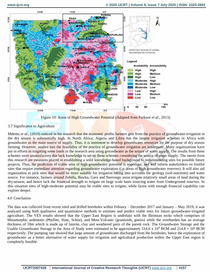
3.6 Areas of favourable groundwater Potential
The map shows areas of high groundwater potential, the demarcated area (Northern Eastern Corner of the Map) is the area of
focus (Forkour et al., 2013). In the future where the idea is to be manifested this map can serve as a guiding block. In the Upper
East Region areas around Zebilla, Bawku, Garu, Navrongo and some few areas in Bolagatanga are promising sites that may be
suitable and favourable for irrigated agricultural activities. Areas within the Bongo and Talensi districts have to review
extensively in terms on fluoride concentration which may cause adverse effects on agriculture.
Page 11
www.ijcrt.org © 2020 IJCRT | Volume 8, Issue 7 July 2020 | ISSN: 2320-2882
IJCRT2007438 International Journal of Creative Research Thoughts (IJCRT) www.ijcrt.org 4157
Figure 10: Areas of High Groundwater Potential (Adapted from Forkuor et al., 2013).
3.7 Significance to Agriculture
Mdemu et al., (2010) noticed in his research that the economic profits farmers gets from the practice of groundwater-irrigation in
the dry season is substantially high. In North Africa; Algeria and Libya has the largest irrigation schemes in Africa with
groundwater as the main source of supply. Thus, it is imminent to develop groundwater resources for the purpose of dry season
farming. However, studies into the feasibility of the practice of groundwater irrigation are inadequate. Many organizations have
put in efforts in irrigating some lands in the research area using groundwater as the source of water supply. The results from these
schemes were unsatisfactory due lack knowledge to set up these schemes considering the source of water supply. The merits from
this research are measures placed in establishing a solid knowledge-based background in recommending sites for possible future
projects. Thus, the prediction of viable sites of high groundwater potential is important, and will inform stakeholders on fruitful
sites that require immediate attention regarding groundwater exploration (i.e. areas of high groundwater reserves). It will also aid
organization to pick sites that would be more suitable for irrigation taking into accounts the geology (soil-nutrients) and water
source. For instance, farmers around Zebilla, Bawku, Garu and Navrongo areas irrigate relatively small areas of land during the
dry-season, and hence lack the financial strength to irrigate on large scale basis sourcing water from Underground reserves. In
this situation sites of high-moderate potential may be viable sites to irrigate, while farms with enough financial capability can
explore deeper.
4.0 Conclusion
The data was collected from recent sited and drilled boreholes within Febuary – December 2017 and January – May 2019, it was
analyzed using both qualitative and quantitative methods to estimate and predict viable sites for future groundwater-irrigated
agriculture. The VES results showed that the Upper East Region is underlain with the Birimian rocks which comprises of
Metamorphic sediments (Phyllite, Slate, Schist), and Meta-Volcanic (granitoids, gneiss) while the overburden has an average
thickness of 18m which is made up of laterite, clay and weathered parts of the parent rock. The Groundwater Storage and the
Usable Groundwater Storage in the Area of Study were estimated to be approximately 514.6 x 10³ BCM and 214.8 × 10³ BCM
respectively. The pumping rate showed that large amount of groundwater discharged from the boreholes, hence the exploration of
groundwater as a better alternative of water supply for irrigation and agricultural production within the Upper East region is
completely feasible.
Page 12
www.ijcrt.org © 2020 IJCRT | Volume 8, Issue 7 July 2020 | ISSN: 2320-2882
IJCRT2007438 International Journal of Creative Research Thoughts (IJCRT) www.ijcrt.org 4158
Acknowledgment
I express my gratitude to my mates at the West Africa Center for Water, Irrigation and Sustainable Africa (WACWISA) for
providing me with an enabling environment to conduct this research. Ramson Adombilla, Chantel and Raymond Tetteh aided
with their constructive critism from the beginning to the end of this work. I will also like to thanks staff of WorldVision Ghana
and Architectural and Engineering Service Limited (AESL) for assisting me with the data collection and analysis. My final thanks
goes to Cosmas Kpiebaya with his time in assisting with my editing and revision.
Reference
Apambire, W. B., (2000). Geochemical modeling and geomedical implications on fluoriferous groundwater in the Upper East
Region of Ghana. Africa Groundwater Literature Archive.
Acheampong, S.Y., Hess, J.W., 1998. Hydrogeologic and hydrochemical framework of the shallow groundwater system in the
southern Voltaian Sedimentary Basin, Ghana. Hydrogeology Journal 6 (4) : 527-537.
Acworth, R.I., 1987. The development of crystalline basement aquifers in a tropical environment. Quarterly Journal of
Engineering Geology & Hydrogeology 20 (4) : 265272.
Adelena, S.M.A., 2009, Monitoring groundwater resources in Sub-Saharan Africa: issues and challenges, Groundwater and
Climate in Africa (Proceedings of the Kampala Conference, June 2008) IAHS Publ. 334.
Africa Climate Policy Center, 2013. Management of Groundwater in Africa: Implications for Meeting MDGs, Livelihood Goals
and Adaptation to Climate Change
Asomaning, G. 1993, Groundwater resources of the Birim basin in Ghana. Journal of African Earth Sciences 15 (3-4): 375-384.
Arhin, E., Jenkin, R.T., Dickson, C., Prosper, M.N., 2015. Regolith mapping of deeply weathered terrain in savannah regions of
the Birimian Lawra Greenstone Belt of Ghana.
Carter, R.C., and Bevan, J.E., 2008. Groundwater Development for poverty alleviation in sub-Saharan Africa. In: Applied
Groundwater Studies of Africa. IAH selected papers on Hydrogeology. Volume 13 (ed. By S. M. A and A.M MacDonald) CRC
Press/Balkema, Leiden, The Netherlands.
Dapaah-Siakwan, S. and Gyau-Boakye, P., 2000. Hydrogeologic framework and borehole yields in Ghana. Hydrogeology
Journal, 8 (4), 405–416.
FAO (Food and Agriculture Organization), 2003. Review of world water resources by country. Rome: Food and Agriculture
Organization of the United Nations, Water Report 23.
Forkuor, G., Pavelic, P., Asare., and Obuobie, A., 2013. Modelling potential areas of groundwater development for agriculture in
northern Ghana using GIS/RS, Hydrological Sciences Journal, 58:2, 437-451,
Martin, N., and van de Giesen, N., 2005. Spatial distribution of groundwater production and development potential in the Volta
River Basin of Ghana and Burkina Faso. Water International, 30 (2), 239–249.
Mdemu, M., Laube, W., and Barry, B., 2010. Temporal water productivity of tomato irrigated from a small reservoir and hand-
dug-wells in dry season cropping in the Upper East Region, Ghana. Journal of Applied Irrigation Science, 45 (1), 75–93.
Mohamaden, M.I.I., Ehab, D., 2017. Application of Electrical Resistivity for groundwater exploration in Wadi Rahaba,
Shalateen, Eqypt. NRIAG Journal of Astronomy and Geophysics.
Obuobie E , Barry B., 2010. Groundwater in sub-Saharan Africa: Implications for food security and livelihoods, Ghana Country
Status on Groundwater, Final Report.
Schoeller, H., 1967. Quantitative evaluation of groundwater resources. In: Methods and Techniques of Groundwater Investigation
and Dev.. UN Water Resources Series 33: 21-44
Shaibu, A-G., Kpiebaya, P., 2020. Groundwater Resources as a Resilient Alternative for Irrigation in the Upper West Region of
Ghana. International Journal of Innovative Research and Technology; ISSN No:-2456-2165. Volume 5, Issue 6, Page 1121-1130
Page 13
www.ijcrt.org © 2020 IJCRT | Volume 8, Issue 7 July 2020 | ISSN: 2320-2882
IJCRT2007438 International Journal of Creative Research Thoughts (IJCRT) www.ijcrt.org 4159
Shaibu, A-G., Kpiebaya, P., 2020. Hydrogeological Study of Groundwater for Dry Season Farming in Norrthern region of
Ghana. Research Journal of Applied Science, 15: 187-196
Shah, T., Himanshu, k., Shankar, P.V. 2007. Groundwater: a global assessment of scale and significance. In: D. Molden, ed.
Water for food, water for life: a comprehensive assessment of water management in agriculture. London: Earthscan, and
Colombo: International Water Management Institute
Wikipedia contributors, (2020, July 16), CWSA. In Wikipedia. The Free Encyclopedia, Retrieved 05:39, 7th July, 2020.
Zango, M.S., Anim-Gyampo, M., Ampadu, B., 2014. Assessment of Groundwater Sustainability in the Bawku East Municipality
of Ghana. Journal of Sustainable Development, Published by Canadian Center of Science and Education; Vol. 7, No. 3; 2014
ISSN 1913-9063 E-ISSN 1913-9071