Bon p (Update the date and the version number on the cover page and the date in the footer. If the date or version number doesn’t update in the footer, you will have to do it manually by going to the footer, right click in the appropriate field and ‘update field’ . Go to show next to check all footers) Document Status Responsibility Name Author Reviewer Approver Revision Status Version Date Reason for Issue 0.1 0.2 0.3 Disclaimer This is a draft document for review by specified persons at Auckland Transport and the New Zealand Transport Agency. This draft will subsequently be updated following consideration of the comments from the persons at Auckland Transport and the New Zealand Transport Agency. This document is therefore still in a draft form and is subject to change. The document should not be disclosed in response to requests under the Official Information Act 1982 or Local Government Official Information and Meetings Act 1987 without seeking legal advice. Drury Central and Paerata Stations Assessment of Transport Effects September 2021 Version 1 Prepared for KiwiRail Holdings Limited by Te Tupu Ngātahi
Transcript
Bon p
(Update the date and the version number on the cover page and the date in the footer. If the date or
version number doesn’t update in the footer, you will have to do it manually by going to the footer,
right click in the appropriate field and ‘update field’. Go to show next to check all footers)
Document Status
Responsibility Name
Author
Reviewer
Approver
Revision Status
Version Date Reason for Issue
0.1
0.2
0.3
Disclaimer
This is a draft document for review by specified persons at Auckland Transport and the New Zealand
Transport Agency. This draft will subsequently be updated following consideration of the comments
from the persons at Auckland Transport and the New Zealand Transport Agency. This document is
therefore still in a draft form and is subject to change. The document should not be disclosed in
response to requests under the Official Information Act 1982 or Local Government Official Information
and Meetings Act 1987 without seeking legal advice.
Drury Central and Paerata Stations Assessment of Transport Effects
September 2021
Version 1
Prepared for KiwiRail Holdings Limited by Te Tupu Ngātahi
Assessment of Transport Effects
September 2021 | 2 | i Te Tupu Ngātahi Supporting Growth
Document Status
Responsibility Name
Author Siân Marek – Transport Planner
Ayesha Weerappulige – Transport Planner
Reviewer James Ellison – Transport Planning Lead
Liam Winter – Planning Lead
Approver Andrew Murray, Transport Planning Discipline Lead
Craig Hind – Project Lead
Revision Status
Version Date Reason for Issue
0.1 April 2021 First Draft
0.2 May.2021 Final Draft
1.0 September 2021 Final
Assessment of Transport Effects
September 2021 | 2 | ii Te Tupu Ngātahi Supporting Growth
1/September/2021 | Version 1 | 15 Te Tupu Ngātahi Supporting Growth
and the area is urbanising. However, the transport assessment has used 2048+ to assess the impacts
of each station as part of the wider long-term transport network. The exact timing of other projects
within the area (e.g. other Te Tupu Ngātahi projects such as the Pukekohe Expressway, SH22 North
Connection, and SH22 South Connection, with further details outlined in Section 3.3.2 of this report)
are not known and the full supporting network is not expected to be in place by 2038. As such, 2048+
was used to assess the effects in the entire future network, assessing against the full growth extent
anticipated.
A number of modelling forecast years have been used for this assessment. The purpose of each
modelling baseline year and Project assumptions are summarised in Table 2-2.
Table 2-2: Assessment Purpose and Assumptions for each Modelling Year
Year Assessment Purpose and Assumptions
2016 Baseline year, which does not include the planned Drury Central or Paerata Stations in the
network
2028 Representative of the existing environment with the inclusion of Drury Central Station and
Paerata Station assumed in the network. Other projects with confirmed funding (e.g. through
NZUP) by this date are also included (refer to Table 5-20 for a list of inclusions).
2038 Drury Central Station, Paerata Station and Drury West Station are assumed in the network, with
the addition of a number of projects planned for implementation by this date (refer to Table 5-20
for a list of inclusions)
2048+ All stations and the South IBC network are included in the model, in addition to other confirmed
projects. Full build-out of development is assumed (refer to Table 5-20 for a list of inclusions)
Detailed modelling assumptions for projects assumed in each year are outlined in Appendix A.
The modelling years have been assessed under various scenarios where the Drury Central and
Paerata Stations are included in the network, and where they are excluded. The different scenarios
which are outlined in Table 2-3 will be referred to when assessing the positive effects and operational
effects in the short term and long term.
There is a considerable degree of uncertainty around the timing and extent of many supporting
projects that were identified in the South IBC. This has been amplified in the short term with the
application to many infrastructure projects of NZUP funding that has accelerated implementation in
many cases. With the announcement that Mill Road will no longer be funded in the South in the near
term, it has pushed back the likely date of implementation. In order to understand better the impact of
Mill Road, separate scenarios were created to understand the effect with and without this project. The
implication of delaying Mill Road is further discussed in the assessment of operational effects.
Table 2-3: Assessed scenarios with descriptions
Scenario Description
No Rail Station Projects
Drury Central, Drury West and Paerata Stations are not present in the future
network
Assessment of Transport Effects
1/September/2021 | Version 1 | 16 Te Tupu Ngātahi Supporting Growth
Scenario Description
No Drury Central Station
Project
Drury West and Paerata Stations are present are in the future network
No Paerata Station Project Drury Central and Drury West Stations are present are in the future network
All Rail Station Projects
Drury Central, Drury West and Paerata Stations are present in the future
network
2.4.2.2 Modelling Tools
For each of the modelling years, assessment has been undertaken using forecasting transport
models, owned by the Auckland Forecasting Centre (AFC), to estimate and compare travel and
network performance. The models used include:
• The Macro Strategic Model (MSM) - which creates estimates of car, truck and public transport
(PT) movements at a regional level based on land use, network and policy inputs. This model
is the primary tool to estimate future PT usage. Generally, this model is run using regional
assumptions as per recent Auckland Transport Alignment Project plans, but with scenario-
specific inputs in the growth areas.
• A local traffic model (SATURN). This uses the traffic demands from MSM on a more detailed
representation of the road network.
• A strategic active mode (walk/cycling) model (SAMM). This tool gives strategic-level
estimates of walking and cycling demands.
• An programme-specific ‘station access tool’ (SAT) that estimates a range of scenarios of
people accessing stations. This uses combined station-access estimates from MSM and re-
estimates potential shift to sub-modes such as walking/cycling, park and ride, bus, based on
relative travel costs and levels of service. This tool is only used to provide estimates of
walking and cycling to major stations.
• SIDRA modelling has been undertaken to assess the operational outputs of key intersections
in the surrounding network and for accessing the stations. MSM was used to inform
assessment of the public transport network components.
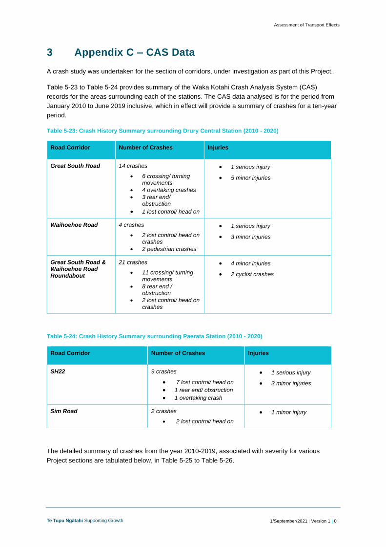
In addition to modelling software, Crash Analysis System (CAS) data has also been extracted to
determine crash rates over the past 10 years on any existing alignments. The purpose of extracting
this data was to assess crash trends in the existing environment and understand potential mitigations
that can be made in the surrounding network.
2.4.3 Summary of Approach to Operational Transport Assessment
The operational transport assessment of impacts of each station on the future environment was
undertaken by assessing each network component. For each component, an assessment has been
undertaken ‘without the Project’ and ‘with the Project’ to highlight the impact of having the Project in
the receiving environment.
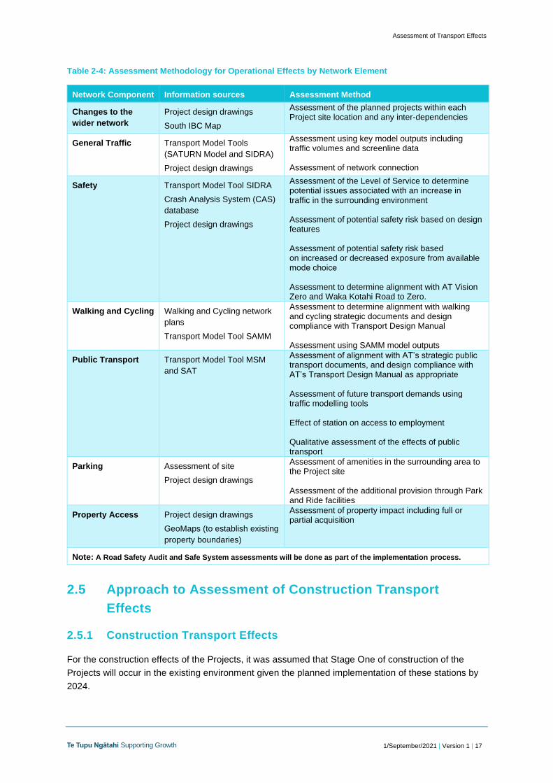
Table 2-4 summarises how each mode/element of transport has been assessed in terms of
operational effects as a result of the Projects.
Assessment of Transport Effects
1/September/2021 | Version 1 | 17 Te Tupu Ngātahi Supporting Growth
Table 2-4: Assessment Methodology for Operational Effects by Network Element
Network Component Information sources Assessment Method
Changes to the
wider network
Project design drawings
South IBC Map
Assessment of the planned projects within each Project site location and any inter-dependencies
General Traffic Transport Model Tools
(SATURN Model and SIDRA)
Project design drawings
Assessment using key model outputs including traffic volumes and screenline data Assessment of network connection
Safety Transport Model Tool SIDRA
Crash Analysis System (CAS)
database
Project design drawings
Assessment of the Level of Service to determine potential issues associated with an increase in traffic in the surrounding environment Assessment of potential safety risk based on design features Assessment of potential safety risk based on increased or decreased exposure from available mode choice Assessment to determine alignment with AT Vision Zero and Waka Kotahi Road to Zero.
Walking and Cycling Walking and Cycling network
plans
Transport Model Tool SAMM
Assessment to determine alignment with walking and cycling strategic documents and design compliance with Transport Design Manual Assessment using SAMM model outputs
Public Transport Transport Model Tool MSM
and SAT
Assessment of alignment with AT’s strategic public transport documents, and design compliance with AT’s Transport Design Manual as appropriate Assessment of future transport demands using traffic modelling tools Effect of station on access to employment Qualitative assessment of the effects of public transport
Parking Assessment of site
Project design drawings
Assessment of amenities in the surrounding area to the Project site Assessment of the additional provision through Park and Ride facilities
Property Access Project design drawings
GeoMaps (to establish existing
property boundaries)
Assessment of property impact including full or partial acquisition
Note: A Road Safety Audit and Safe System assessments will be done as part of the implementation process.
2.5 Approach to Assessment of Construction Transport
Effects
2.5.1 Construction Transport Effects
For the construction effects of the Projects, it was assumed that Stage One of construction of the
Projects will occur in the existing environment given the planned implementation of these stations by
2024.
Assessment of Transport Effects
1/September/2021 | Version 1 | 18 Te Tupu Ngātahi Supporting Growth
The construction for the full build out footprint was assessed in the future environment when the
planned network is expected to be fully developed. As a result, in the future environment the roads
will be further developed for construction traffic use and mitigation will have to be appropriate for the
increase in urbanisation in the growth areas.
In order to assess the potential construction traffic effects, an indicative construction methodology has
identified the following key elements:
• The expected number of movements related to construction vehicles to and from each
potential construction site access point
• Potential haulage routes noting the cut and fill requirements of the site and potential closures.
Based on the above, the following assessment methodology has been adopted:
• Identification of any locations where the additional volumes are expected to exceed the
available capacity on the network and identify any mitigation measures, if necessary
• Identification of any works that should not occur at the same time.
Other additional qualitative assessments included:
• Identification and assessment of potential conflict areas with vulnerable road users
• Impact of construction traffic on future public transport operations.
2.5.2 Temporary Traffic Management
The impact of any temporary traffic management measures implemented to undertake the Projects
will be assessed prior to construction when a greater level of detail is available in terms of the specific
construction methodology and traffic environment. It is noted that the construction of the stations will
be ‘offline’ and therefore the temporary traffic management will focus on site access.
Access to the sites will be through a mixture of access points off the existing road network and
components of the future planned road network, such as the new accessways to each of the stations.
Assessment of Transport Effects
1/September/2021 | Version 1 | 19 Te Tupu Ngātahi Supporting Growth
3 Wider Existing and Future Network
This section provides the wider transport context around what the existing and the likely future
environment will look like in the areas in which the Projects are proposed in a 2048+ scenario.
3.1 Land Use
3.1.1 Existing Land Use
The study areas of Drury-Ōpāheke and Pukekohe-Paerata largely comprise of rural residential, and
agricultural land. There is limited infrastructure in these areas. There are business industrial zones in
Drury Central, to the west of Great South Road and in the southeast area of Drury, near Quarry Road.
There is a residential area near Paerata and the area between Paerata and Pukekohe is
predominantly rural. The Pukekohe area comprises residential and business areas.
3.1.2 Proposed Future Land Use
As discussed in the AEE report, the Drury-Ōpāheke Structure Plan and the Pukekohe-Paerata
Structure Plan outline the expected pattern of urban development and the future transport projects
(subject to planning and funding approvals) surrounding the Project areas. The Structure Plans and
AUP:OP zonings are shown in Figure 3-1 and Figure 3-2.
Figure 3-1: Drury – Ōpāheke Structure Plan and AUP:OP zoning
Assessment of Transport Effects
1/September/2021 | Version 1 | 20 Te Tupu Ngātahi Supporting Growth
Figure 3-2: Pukekohe-Paerata Structure Plan and AUP:OP zoning
There are some known Plan Changes in the area that will impact on the future land use, including:
• Drury Centre (PC 48), which proposes to rezone 95 ha in Drury from FUZ to a mix of
business (metropolitan centre and mixed use) and open space zones; and apply a Precinct to
the area
• Drury East (PC 49), which proposes to rezone 184 ha of land in Drury from FUZ to a mix of
residential (terrace housing and apartment buildings, mixed housing urban and suburban) and
business (mixed use) zones; and apply a Precinct to the area.
Waihoehoe (PC 50) which proposes to rezone 49 ha of land in Drury from FUZ to a residential
(terrace housing and apartment buildings) zone; and apply a Precinct to the area. It is also noted that
Paerata Rise5 is a development currently underway to the west of the existing railway line at Paerata,
within the Residential – Mixed Housing Urban Zone. It is planned to consist of approximately 4,500
dwellings on 300 ha of land, with 5ha of green spaces that will integrate with Paerata Station.
The structure plan shows indicative locations of local and collector roads in the growth areas.
However, the location and design of local and collector roads are subject to detailed plan changes
and sub-division planning. Hence, the exact local network location is not confirmed.
5 https://Paeratarise.co.nz/master-plan/
Assessment of Transport Effects
1/September/2021 | Version 1 | 21 Te Tupu Ngātahi Supporting Growth
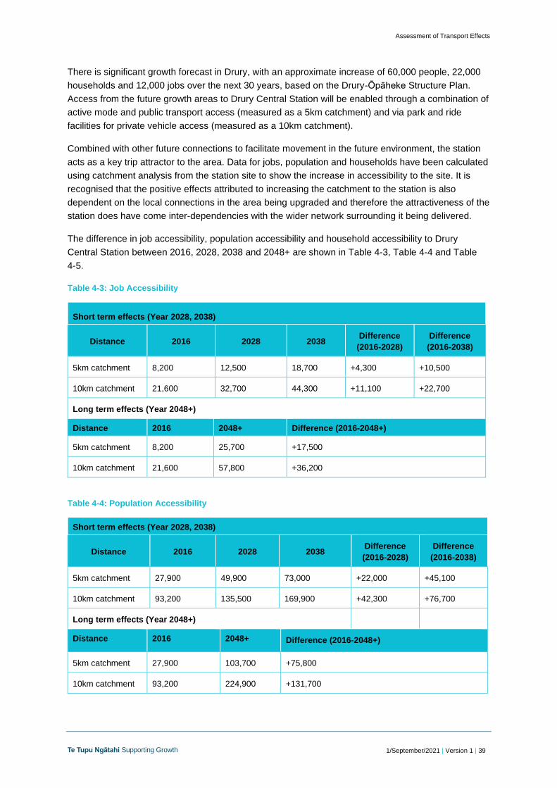
3.2 Population, Household and Employment Forecasts
3.2.1 Existing Data
The Southern growth area6 is approximately 20km south of Auckland’s central city and is
approximately 30km in length. In 2016, the number of households in the overall South area (which
includes Takanini, Drury and Pukekohe) was approximately 61,0007. The population was
approximately 192,000 and there were approximately 44,000 jobs in the South area.
3.2.2 Future Forecast
As previously noted, the Southern growth area makes up the largest proportion of future urban areas
in Auckland (45%). It includes the large future urban areas of Takaanini, Ōpāheke Drury, Drury West,
and Pukekohe-Paerata. There are live-zoned areas currently under development in both Drury West
and Pukekohe-Paerata.
The Te Tupu Ngātahi South IBC established the following main assumptions and findings:
• Growth in the overall South area is expected to rise from 61,000 dwellings in 2016 to 131,000
by total build out in 2048+. This is expected to cater for a population of 356,000 people by
2048+, in comparison to 193,000 in 2016. 8
• The bulk of the South’s growth is anticipated to occur within the Drury-Ōpāheke growth area,
increasing from a current population of just over 3,300 to a population of around 62,000 by
2048+. Provision of employment opportunities is expected to rise from 2000 in 2016 to 11,300
in 2048+.
3.3 Transport Network
3.3.1 Existing Transport Network
State Highway 1 (SH1) is a strategic link facilitating regional movement and access to Drury,
Papakura, and North Waikato. The state highway is also a key route between South Auckland and the
Auckland CBD. State Highway 22 (SH22) also provides a key link to southern areas such as Paerata,
Pukekohe, Patumahoe and Waiuku. Urban arterials within the South network include Great South
Road, which provides access between the state highways and local roads. Many local collector roads
are in the network, including Waihoehoe Road, Burtt Road and Sim Road.
The NIMT 2-track rail line runs through the existing stations located at Papakura and Pukekohe. The
section of the rail line between Papakura and Pukekohe is used for rail freight9 and passenger trains
(2 trains per hour in the peak period). The passenger trains using this section of the track are
currently diesel, and the line is planned to be electrified under the KiwiRail Papakura to Pukekohe
electrification project (P2P)10.
6 The ‘southern growth area’ encompasses the Future Urban Zones and growth planned from Takaanini southbound to Pukekohe at the Waikato
As shown, there are benefits from having the Drury Central and Paerata Stations in the network,
particularly with regards to CO2 and fuel consumption litres (FC). The impact on the future, long-term
network is shown in Table 4-12, highlighting the long-term benefits of having all the stations in the
future network.
Table 4-12: Yearly Greenhouse Gas Emissions and Fuel Consumption with and without Drury Central, Drury West and Paerata Stations in the network (2048+)
Long term effects (Year 2048+)
Emissions
Yearly emissions (uses VEPM 6.1 Rates)
All Rail Station Projects (2048+)
No Rail Station Projects (2048+)
Difference
CO kg 2,373,000 2,378,000 5,000
CO2 kg 1,643,903,000 1,647,112,000 3,209,000
FC litres 649,123,000 650,421,000 1,298,000
As shown, the amount of emissions is predicted to be reduced with the stations in both the short term
and long-term network. The difference between 2028 and 2048+ is highly notable, highlighting the
impacts that growth will have. This is particularly notable when comparing the differences in CO2
emissions, indicating that having the stations in the future network will minimise the amount of
Assessment of Transport Effects
1/September/2021 | Version 1 | 46 Te Tupu Ngātahi Supporting Growth
emissions produced through private vehicles as the stations cause an overall reduction in private
vehicle use.
4.5.1.6 Safety Benefits
Having the Drury Central Station in the future network is seen to have a positive impact on safety
given that the increase in access to the NIMT will result in a modal shift by reducing private vehicle
trips for intra-regional movements, reducing the number of private vehicles on the network.
Safety benefits can also be monetised to highlight the positive impact of reducing private vehicle use.
safety impacts of having more vehicles on the surrounding network can be calculated using
monetised crash reduction benefits to estimate the average crash costs per vehicle kilometre travelled
(VKT) for various road categories. Using this approach, there is a crash saving of $0.6m annual
benefits in 2028 by having the Drury Central and Paerata Stations. By comparing all stations (Drury
Central, Paerata and Drury West Stations) in the future network (2048+) to no stations in the future
network, the results shown a crash saving of $2.3m annual benefits.
The Project is well aligned with the Government Policy Statement as the Project improves the safety
of the rail network and mode shift will make the overall land transport system safer. The Project
increases the use of freight and passenger rail and supports the Government’s Road to Zero strategy
by providing safer transport options and reducing traffic volumes on roads over time, to improve
overall road safety.
Safe system guidance provides that crash risk can be addressed through reducing exposure levels
and specifically reducing exposure of pedestrians to crashes. The Project reduces exposure between
vehicles and pedestrians through reducing vehicle volumes and providing public transport such as rail
to achieve the required mode shift.
The approach to associated transport infrastructure has used safe system guidance to separate out
different modes of transport with a priority to vulnerable road users. In the development of the Station
design the transport facilities have employed roundabouts where possible due to the safety benefits of
this intersection form. The footprint of these roundabouts have been designed in such a manner that
they could be converted to traffic signals in the future once the Drury East area further urbanises.
4.5.2 Assessment of Operational Effects
This section describes how each element of the transport system will function operationally after
construction of the Project, and therefore the effect it will have on the existing and likely future
environment. Given the intention of the Project is to provide for and support the urban development
planned in the area, the future environment has been informed by the planned urban development. In
this section, the following impacts will be assessed:
• The impact on the future environment without the Project (and also without the Paerata
Station and Drury West Station Projects)
o 2048+ network with all three stations absent, referred to as ‘No Rail Station Projects’
• The impact on the future environment with the Project
o 2048+ network with Drury Central and Drury West22, Paerata station, referred to as ‘All
Rail Station Projects’
22 Drury West is part of a separate consent application. However, when the full-build impacts considers and includes Drury West Station as this
station will be built and be operational in the 2048+ All Stations Scenario.
Assessment of Transport Effects
1/September/2021 | Version 1 | 47 Te Tupu Ngātahi Supporting Growth
Any operational impacts to the existing environment (2028) will also be noted where the impacts will
be at a worse case than in 2048+.
4.5.2.1 Assessment Without the Project
This section considers the operational transport impacts where the Project does not exist in the future
environment (No Rail Station Projects scenario). This assessment has been undertaken to
demonstrate what the impact will be in the future environment without the Project in place, to use as a
baseline for assessing any transport effects.
Changes to the Wider Network
Without the Project in place, Flanagan Road will retain its existing intersection with Waihoehoe Road
and will not be realigned to retain access to the wider network. However, it is assumed that the
accessway to Flanagan Road will be removed once the Waihoehoe FTN is implemented.
General Traffic
Without the Project in place, there will be less access to the NIMT and therefore more intra-regional
trips will be likely to travel via private vehicle given the limited modal choice. As such, there will be in
an increase in vehicles on the wider surrounding network (as shown in later sections in Table 4-19).
Without the Project, trips that may have used Park and Ride facilities at Drury Central Station to
access the wider network via the rail line would be limited to driving elsewhere to use Park and Ride
facilities (such as at Pukekohe or Papakura), or restricted to completing their journeys by private
vehicle rather than mixed modal use.
Some trips will reroute to other Park and Ride facilities, but these will be limited by parking spaces
available as the demand at these stations will increase. Vehicles could still have access to the station
by routing to the Drury West (approximately 2-3km westbound) Park and Ride facilities. However,
given the limited parking spaces likely proposed at this other station, there will be some trips that will
revert to vehicle use for the entirety of their trip.
Safety
Without the Drury Central station in the future environment, the associated reduction in vehicles on
the road and the subsequent safety benefits will not be achieved to the same extent. This disbenefit is
exacerbated further if all three stations planned in the future environment do not come to fruition.
Without Drury Central Station in the future environment, there will be an increased number of vehicles
on the future network compared to the scenario without the station. This is because there will be lower
increases of people shifting towards public transport options which have a lower risk associated with
them. The outcome could be high crash exposure levels due to the high number of vehicles in the
network.
Walking and Cycling
Without the Project in the future environment, the implications for walking and cycling are as follows:
• Walking and cycling trips that would have occurred for commuting or passenger purposes (i.e.
travelling to/from the station), will not exist without the station in place as a main trip attractor.
Therefore, the associated health benefits with increased active mode users will not be
Assessment of Transport Effects
1/September/2021 | Version 1 | 48 Te Tupu Ngātahi Supporting Growth
achieved without the Project as these trips would otherwise be undertaken via private
vehicles
• The future walking and cycling network will be less utilised, as without a station there will be
no trip generator in this area, reducing the benefits of other projects such as the Regional
Active Mode Corridor or Waihoehoe Road FTN which may be unconsented or protected
• The ability to contribute to mode shift towards active modes will be severely compromised if
the Project is not implemented, leading to further reliance on low-occupancy vehicle use and
exacerbating congestion
• A reduction in walking and cycling in the network will lead to further reliance on low-
occupancy vehicle use, further exacerbating congestion and safety issues both locally and on
the wider network
• The lack of provision of sustainable travel choices will result in a lost opportunity to switch to
low-emission transport options. With the increase in population and subsequent travel
demand rising, this will result in an increase in emissions from continuation of car-based
travel and an associated increase in adverse environmental and health effects. This is due to
the expected shift from potential train-based trips to car-based trips due to the absence of the
Project.
The predicted 2048+ usage of the walking and cycling facilities surrounding the Project (both with and
without all stations in the future network) are shown in Table 4-13. Movement estimates were taken
from the Strategic Active Mode Model (SAMM) and Station Access Tool. These numbers are based
on average daily flows (both directions) on the network surrounding Drury Central Station.
Table 4-13: Daily active mode trips predicted in 2048+ surrounding Drury Central Station
Scenario Corridors Walking (Daily
Flows)
Cycling
(Daily Flows)
2048+ No Rail Station
Projects
Great South Road, Waihoehoe Road,
Flanagan Road, Regional Active Mode
Corridor*
1,900 400
2048+ All Rail Station
Projects
14,000 7,700
*expected to be key routes for both walking and cycling
As shown, not having the Project nor any new stations included in the network largely impacts the
wider walking and cycling network, indicating that Drury Central Station is a key trip attractor for these
types of modes.
The effects to walking and cycling are localised, therefore if Drury Central Station was no longer in the
network there would still be some active mode movement; however, the local rate would be lower.
The proposed Drury West Station is approximately 2-3kms away from the Project; therefore, it is
expected that some trips within the Drury Central catchment for walking and cycling would reroute to
this alternative station. However, this additional distance for movement will detract some trips.
Public Transport
In the scenario where there are no new stations included in the wider network (Drury Central, Drury
West nor Paerata), passenger and freight trains will continue to operate. However, passenger access
to the NIMT will be via Papakura or Pukekohe Stations. In the predicted future environment, when the
areas surrounding the stations are fully urbanised, the absence of any of the new stations in the
Assessment of Transport Effects
1/September/2021 | Version 1 | 49 Te Tupu Ngātahi Supporting Growth
network will result in increased traffic volumes directed towards the existing stations and more
vehicles travelling intra-regionally.
Without the Project in the future environment, there will be less demand to use the proposed bus
services within the Drury Central area given the bus network would no longer be directed to the
station. Instead of using buses to connect to the station to facilitate longer trips via the rail, these trips
would become more localised. Having Drury Central station in the network therefore supports the
wider Public Transport strategy of providing a connected network.
The following undesirable outcomes are likely to occur if future growth progresses and Drury Central
Station is not in the future network:
• Access to employment and social amenities will be compromised by congested traffic due to
low public transport connectivity and continuation of car-based travel
• Local access to key trip attractors and regional employment opportunities will be limited
without access via the station
• Poor integration with the proposed FTN services would result, particularly on the proposed
Waihoehoe Road FTN. Waihoehoe Road FTN may be less attractive for bus or active mode
users, who would otherwise connect to the rail network at Drury Central Station. Some bus
routes could reroute to other stations; however, the attractiveness of using public transport via
the Drury Central region would decrease given the increased journey time to access the rail
network may result in longer trips
• The ability to contribute to transformational mode shift and increased ridership will be
compromised if additional provision for reliable public transport is not provided. Modal shift to
public transport would reduce in the area given the modal choice of rail will not be easily
accessible for those living in the Drury area. Hence, people living in this area will have limited
sustainable modal choices and resulting in private vehicle use
• The lack of provision for reliable public transport choice will result in increased emissions from
continuation of car-based travel leading to adverse environmental and health effects
• The lack of provision of a reliable public transport choice will lead to delays and unreliability
on the wider general traffic network
• Access to the NIMT will be provided adjacent to the Drury Central region in Drury West and in
Papakura however, the Drury Central catchment would not be facilitated with direct access in
the area.
Parking
Without the Project in place, there are no known parking facilities planned in the immediate area that
are directly linked to the planned infrastructure plans in the area. There is expected to be Park and
Ride facilities at Drury West Station and Paerata Station, however these are several kilometres from
the Project site. Currently, there is no formal parking in the surrounding area. As the area develops in
the future, car parking will be provided, and it is assumed that these parking facilities will be
developer-led.
As areas in the south develop, there will be increasing demand for park and ride facilities at the
existing Papakura and Pukekohe station as well as at the proposed Paerata and Drury West stations.
Without the Drury Central Station Project, the demand and pressure at the existing and other stations
will remain or continue to increase.
Property Access
Assessment of Transport Effects
1/September/2021 | Version 1 | 50 Te Tupu Ngātahi Supporting Growth
For properties along Waihoehoe Road, property access surrounding the site location is expected to
be impacted by the proposed Waihoehoe FTN designation. Without the Drury Central Station Project
in place, access from Flanagan Road will not be realigned and these existing properties will not have
their access impacted.
4.5.2.2 Assessment with the Project
This section considers the operational transport impacts where the Project exists in the future
environment (2048+ All Rail Station Projects network with Drury Central, Drury West and Paerata
Stations).
Changes to the Wider Network
With the Project in the network, Flanagan Road will be realigned and the existing intersection with
Waihoehoe Road will be removed. The partial closure and realignment of Flanagan Road will result in
a change of access for residents given that they will have to reroute to reach Waihoehoe Road,
increasing delay and reducing convenience for residents. Given that the local road is within the future
urban zone, it is assumed that this will impact on the short-term residents but will be redesigned in the
future urban context to mitigate delay In all time periods, alternative access will be provided for these
residents that are impacted by network changes.
General Traffic
For general traffic, the Project serves as a key mode shift transition away from private vehicles to
sustainable transport options for intra-regional trips. Vehicle trip distances will be generally shorter as
vehicles will access the station and use rail for intra-regional trips. The Project provides attractive and
sustainable transport option for the area.
The surrounding traffic network has been assessed in 2028 with and without Drury Central Station in
the network, as shown in Table 4-14.
Table 4-14: Average Daily Traffic (ADT) along roads surrounding Drury Central
Road 2028 ADT (without Drury
Central Station)
2028 ADT (with Drury
Central Station)
Difference in ADT
Waihoehoe Road 7,100 7,700 +600
Great South Road 11,200 10,800 -400
As shown, there is little difference in the existing environment to the local road network with the
Project in place. However, the performance of intersections is slightly impacted when the station is in
the network. Table 4-16 and Error! Reference source not found. summarise the SIDRA outputs
when assessing the Waihoehoe Road/Great South Road and Waihoehoe Road/Station accessway
intersection with and without Drury Central Station in the network. Both intersections have been
assessed as roundabouts initially in-line with the safe system approach.
Assessment of Transport Effects
1/September/2021 | Version 1 | 51 Te Tupu Ngātahi Supporting Growth
Table 4-15: Station Access/ Waihoehoe Road intersection SIDRA results in 2028 and 2038
Year and
Scenario
Peak Period Overall Level
of Service
Degree of
Saturation (worst
movement)
Average Delay
(sec)
Maximum
Queue Distance
(m)
2028 with Drury
Central Station
AM Peak A 0.28 3.6 11.4
PM Peak A 0.26 2.2 9.3
2028 without
Drury Central
Station
AM Peak A 0.20 2.1 7.6
PM Peak A 0.28 2.1 9.7
2038 with Drury
Central Station
AM Peak A 0.43 3.3 22.2
PM Peak A 0.39 2.7 16.2
2038 without
Drury Central
Station
AM Peak A 0.39 2.5 18.2
PM Peak A 0.35 2.5 13.1
It can be seen from the results in Table 4-15 that a single lane approach roundabout delivers
sufficient performance and capacity to support the station without excessive impact on network
performance. This intersection is connecting solely to the Drury Central Station from Waihoehoe
1/September/2021 | Version 1 | 56 Te Tupu Ngātahi Supporting Growth
Policy/Standard Network Component Assessment
30km/hr. The traffic speeds surrounding the
Project are proposed to be 50km/hr; therefore,
the proposed design of the walking and cycling
facilities is considered to be appropriate for
these standards. The speed within Drury Central
interchange is expected to be 30km/h, also
meeting Vision Zero standards.
Auckland Transport
Design Manual27
Footpaths:
approximately 1.8m minimum
Cycle Paths:
approximately 2.0m minimum
An approximate 1.8m wide footpath is enabled
on all corridors within the Project and a 2.0m
approximate cycle path is enabled. This is in
accordance with the AT TDM requirements.
The Project is located in an area that will include a town centre, terrace housing and apartment
buildings and mixed housing zones within walkable distance to the east and north of the Project,
indicating that the short-distance catchment (approximately within a 5km catchment) will facilitate a
number of walking and cycling trips to access the station. The surrounding land use and active mode
desire lines are shown in Figure 4-7.These will eventuate fully as the urbanisation of the area takes
place in the long term.
Figure 4-7:Long Term Active Mode desire lines to Drury Central Station28
27 Auckland Transport – Transport Design Manual: https://at.govt.nz/about-us/manuals-guidelines/roads-and-streets-
framework-and-the-transport-design-manual/ 28 High-level desire lines shown, further details included in South Rail Detailed Business Case, Appendix E1.2 – Rail Station and Transport
1/September/2021 | Version 1 | 57 Te Tupu Ngātahi Supporting Growth
It is expected that additional pedestrian movements would be induced to access the station. In the
short term, these are expected to be low due to the lack of residential development in close proximity
to the station. As urbanisation progresses, it is expected that the large-scale urban infrastructure
upgrades will cater to these pedestrian demands, in particular the Jesmond-to-Waihoehoe West FTN
Upgrade Project which will provide full separated active mode facilities along Waihoehoe Road, and
at the Waihoehoe Road / Great South Road intersection (see section 3.4.2). This upgrade is provided
for in the Drury Arterials NoRs lodged by Auckland Transport.
Prior to the longer-term urbanisation and accompanying infrastructure upgrades, a scenario of
gradually increasing pedestrian movements between the station and the existing industrial area and
community facilities may eventuate. These would use existing footpaths to access the station from
either Great South Road or Waihoehoe Road. There are gaps in that network at the Great South
Road / Waihoehoe Road intersection. It is recommended that pedestrian safety is monitored in this
location, and that interim facilities may be added to the roundabout (depending on when the more
extensive corridor upgrade is implemented).
Active mode benefits are covered in Section 4.5.1.3 of this report.
Public Transport
The Project enables access to economic and social opportunities for current and future residents in
the Drury Central area, via access to the proposed stations. The Project forms part of the wider future
public transport network, providing access to public transport such as trains and buses. Positive
effects such as travel time improvements between centres. These positive effects are detailed in
Section 4.2.1.5 of this report.
It is noted that train users from Pukekohe and Papakura who are travelling to main centres such as
the CBD are expected to experience an additional 40 seconds of travel time along the rail line, given
the inclusion of each extra train stop in the future network. However, this is viewed as a minimal effect
given that accessibility to Drury Central will be greatly enhanced.
Exact layout of the bus station interchange will be confirmed at the detailed design stage and will be
guided by the AT Transport Design Manual where appropriate.
Parking
The Project station interchange provides space for approximately 500 car parks to be used for Park
and Ride, as well as enabling two parking spaces for pick/drop off and four parking spaces to be used
for a taxi rank at full build. The park and ride facilities will increase accessibility to the Drury Central
Station for a wider catchment.
The park and ride capacities at the Drury Central Station is interdependent with the demand and
capacity of other stations in the area. An additional positive benefit for the Project is that the Drury
Central park and ride station facilities will reduce demand and pressure at other stations such as
Papakura and Pukekohe stations. This will increase parking spaces for people to use at these existing
stations. There is a potential that the park and ride facilities may preclude development which
increase walking and cycling accessibility to the station.
Currently, there is no formal parking near the proposed Drury Central Station. Hence, car parks will
not be reduced in the area and there will be no associated adverse effects. Overall, there are no
adverse effects on parking expected in the area.
Assessment of Transport Effects
1/September/2021 | Version 1 | 58 Te Tupu Ngātahi Supporting Growth
Property Access
Existing property access may be removed or altered in the surrounding network due to the Project as
detailed below. Property access must be maintained; hence, mitigation will be required to ensure
access is retained.
Access to properties around the future Drury Central Station was assessed to understand the various
impacts including safety implications. These impacts will be validated through site visits prior to
implementation of the Project.
Property access impacts due to the Project are expected on Great South Road, Flanagan Road and
Waihoehoe Road. Property access issues which need to be resolved are based on the staging of the
project and whether the properties are fully or partially acquired. Table 4-21 shows which properties
will have their accesses affected and at which stage of the project these access issues will require
mitigation.
Properties which are fully acquired across Stage One and in the full build will not have access issues.
Properties which are partially acquired will have access issues that are to be resolved and access
may need to be reconfigured where necessary.
Assessment of Transport Effects
1/September/2021 | Version 1 | 59 Te Tupu Ngātahi Supporting Growth
Table 4-21: Property access impacts
Property
Impact
Stage One property access issue to
resolve (via partial acquisition):
Full Build property access issue to
resolve (via full acquisition):
54 Flanagan Road Yes No
236 Great South Road Yes (minimal impact) Yes
250 Great South Road Yes Yes
260 Great South Road Yes Yes
31 Waihoehoe Road Yes Yes
41 Waihoehoe Road Yes No
67 Waihoehoe Road Yes No
For properties along Waihoehoe Road, property access surrounding the site location is also expected
to be impacted by the proposed Waihoehoe FTN designation in the longer term. The access impacts
for these properties will be covered through the Waihoehoe Road FTN Project.
4.5.2.3 Recommended Measures to Avoid, Remedy or Mitigate Operational Effects
There are some adverse operational effects that have been identified as a result of the Project
operating in both the existing and future environment. The immediate and future impacts, including
mitigation and effect level, are summarised in Table 4-22.
Table 4-22: Potential adverse effects
Assessment
environment Anticipated effect Mitigation
Scale of effect
(post-
mitigation)
Existing
environment
Closure and realignment of Flanagan Road
to general traffic with the addition of an
appropriate intersection on Waihoehoe
Road to provide access to the interchange
and park-and-ride access could increase
delay and reduce convenience for
residents. The location is within the Future
Urban Zone, therefore within an urbanising
environment. Local road access can be
redesigned to suit the future urban context.
It is further assumed that Flanagan Road
will not be connected to the network post-
implementation of the Waihoehoe FTN
upgrade.
No specific mitigation
required
Low adverse
effect
Assessment of Transport Effects
1/September/2021 | Version 1 | 60 Te Tupu Ngātahi Supporting Growth
Assessment
environment Anticipated effect Mitigation
Scale of effect
(post-
mitigation)
Existing
environment
and future
environment
Minor increases in traffic volumes in the
surrounding local network, such as along
Waihoehoe Road and Great South Road,
will have some travel time impact to local
road users and those accessing the station.
The increase in traffic along local roads is
minimal at a daily level and does not, in
isolation trigger the need to upgrade the
road for additional capacity
Waihoehoe Road is subject to an upgrade
in the future environment as part of a
separate project
The increase to the immediate local
network is balanced through a reduction to
traffic elsewhere in the network, such as
along Mill Road and SH1
No mitigation required
given a balance in traffic
volumes on the network
over time
Low adverse
effect
Existing
environment
Short-term impact at the adjacent
intersection of Waihoehoe Road and Great
South Road from exiting park and ride
traffic
The intersection will be upgraded through separate projects in the future environment
During Stage One of the
Project, a short, left turn
lane of 10m can be added
to the intersection
approach from
Waihoehoe Road to
reduce queue lengths and
improve the overall level
of service, if excessive
queues due to park and
ride eventuate
Low adverse
effect
Existing
environment
and future
environment
Minor delay to train passengers using the existing line, with an additional stop along the NIMT (Paerata Station will also add another stop in the existing environment, while Drury West will add a further stop in the future environment)
Existing users of the rail line will experience
a number of positive benefits to offset the
adverse effects, including:
• an increase in accessibility to
amenities in Drury
• An increase in travel option
locations
• extra capacity at the
Pukekohe/Papakura Park and
Rides
No mitigation required
given the balance of
effects
Low adverse
effect
Assessment of Transport Effects
1/September/2021 | Version 1 | 61 Te Tupu Ngātahi Supporting Growth
Assessment
environment Anticipated effect Mitigation
Scale of effect
(post-
mitigation)
Existing and
future
environment
Safety risk with people crossing the rail lines (away from the grade separated station crossing) to access the station
Mitigation will be required
as part of the consent
such as fencing around
the station. This is an
issue that will be flagged
through a project safety
audit
Low adverse
effect
Existing
environment
Walking and cycling to access the station is a safety concern from existing activities given the gaps in the facilities. Safety concerns are noted after observation of existing active mode facilities on Great South Road and at the Great South Road/ Waihoehoe Road roundabout. Park and Ride will reduce the scale of this concern in the short-term, providing safe access to existing residents. As the area develops, walking and cycling facilities are anticipated to be provided by separate projects associated with that development.
Walking and cycling safety concerns at the Great South Road/ Waihoehoe Road roundabout can be mitigated by providing enhanced crossing facilities
Low adverse
effect
Existing
environment
Existing access to seven properties near the station will be removed or altered in Stage One and/or full build
Future development will not have direct private access on to the Project site
Access to these
properties must be
maintained; therefore,
mitigation is required to
ensure existing or
alternative access is
enabled
Low adverse
effect
4.5.3 Assessment of Construction Effects
This section describes the assessment of potential transport effects during construction of the Project.
Refer to section 4.4 for the description of works during construction. The assessment considered the
construction access and working room requirements for the Stage One station development and the
full build.
The assessment of construction effects was based on the indicative construction method,
construction programme and the nature of works for construction. The indicative construction method
has been developed based on a concept design with assumed use of the most practical construction
techniques and equipment. There are likely alternative methods in the future that could be used to
complete the works; however, this document only intends to capture the traffic impacts based on the
indicative construction method, which is provided in the AEE .
Assessment of Transport Effects
1/September/2021 | Version 1 | 62 Te Tupu Ngātahi Supporting Growth
4.5.3.1 Temporary Traffic Management
It is anticipated that a large portion of the works can be constructed outside the rail corridor for the
Project. The platform and interchange works will typically be carried out adjacent to the operating rail
line and will require multiple rail shutdowns/ Block of Line (BoL) to complete the full scope. Some
works are also adjacent to existing roadways (Great South Road, Flanagan Road and Waihoehoe
Road West) and will require temporary traffic management. Approved temporary traffic management
controls will allow safe entry and exit to and from the site during construction.
The temporary traffic management controls will be for Waihoehoe Road and Great South Road, which
will be used to access the construction site.
Flanagan Road (an existing local access road that connects to Waihoehoe Road) can be used for
initial access until it needs to be excavated. Flanagan Road will be realigned with the existing
accessway closed and removed. In its place, there is a planned new access road that will provide
southbound access from Waihoehoe Road. If access to the Flanagan Road southern properties
needs to be maintained until the new accessway is installed, then a temporary diversion will be
required. Such localised diversion will provide room to allow the early commencement of the station
eastern entry building.
Depending on the timing of the associated road network to the south of the Drury Central Station,
there may also need to be an interim connection to enable access from Waihoehoe Road once
Flanagan Road is closed and the station roads are completed.
4.5.3.2 Expected Construction Traffic Routes
The construction of the Project will require earthworks. The estimated volumes of cut and fill are
approximately 35,600m3 (bulk earthworks only, 39,100m3 including wetland activity) based on the
current indicative design for the full build footprint of the station. Final cut and fill volumes and
earthworks staging will be confirmed following detailed design prior to construction. The construction
traffic movements to accommodate the earthworks and other construction activities will likely result in
an increase in traffic volumes on construction routes used during the construction period of the
Project.
Whilst the construction timing for Stage One is more certain, the future conditions surrounding the site
for the full build out are less certain. For both stages there is a degree of uncertainty associated with
any predicted construction methodology and associated construction routes. This means:
• The routes that will be used by construction vehicles will depend on the locations of quarries
and disposal sites which are not yet certain for the full build.
• The exact location and extent of compound sites/ lay down areas in Stage One is indicative
however, will be within the proposed designations. The exact location and extent of
compound sites/ lay down areas in full build is yet to be determined.
• The timing of construction of other projects could impact on likely future construction vehicle
routes, especially the Waihoehoe West FTN Upgrade and Mill Road corridor for the full build
(depending on the implementation timings of these projects) and the Papakura to Pukekohe
electrification project (Stage One).
Access to compound sites/laydown areas and the construction zone for construction vehicles, plant
and materials will be via site access points on Waihoehoe Road and Great South Road which will
Assessment of Transport Effects
1/September/2021 | Version 1 | 63 Te Tupu Ngātahi Supporting Growth
need to be identified as part of future CTMPs. Details of the routes for construction traffic will likely be
limited to arterial corridors and intersections with adequate vehicle tracking provision.
It is noted that the existing SH1 motorway bridge at the Drury interchange has a height limit of approx.
4.66m. Therefore, any construction vehicles exceeding this limit, are prohibited to go under the
bridge. However, the Drury interchange is expected to be upgraded as part of the SH1 Papakura to
Bombay project and road network vehicle restrictions should be reassessed prior to construction as
this constraint may no longer exist, particularly for the full build of the station. The potential
construction traffic routes are shown below in
Figure 4-8.
Figure 4-8: Potential construction routes for access to Drury Central construction site (OpenStreetMap application)
Assessment of Transport Effects
1/September/2021 | Version 1 | 1 Te Tupu Ngātahi Supporting Growth
4.5.3.3 Expected Construction Traffic Generation
Based on the proposed construction methodology and activities, the estimated duration of work for
Stage One of the Project is between 12 months to 18 months, which includes three phases of
construction works. The full build stage is estimated to take approximately 12 months to 18 months of
construction time, and is an additional construction works stage. From a traffic and transport
perspective, it would be beneficial to complete the full extent of the civil works in Stage One to
minimise any extensive work and prolonged traffic and transport disruption in the future.
The estimated total construction movements include approximately 17,050 heavy truck trips and
22,500 light vehicle trips required for materials and earthwork movements for both stages of the
station construction. Of these trips, approx. 13,600 heavy trucks and 15,000 light vehicles are
expected to be associated with Stage One, and approximately 3,450 heavy trucks and 7,500 light
vehicles are expected to be associated with the full build.
In addition, there will be approximately 100 vehicle movements per day from staff and contractors
during the peak construction periods.
To estimate the daily number of truck movements to and from the site, the following working
assumptions were adopted:
• Working days: 24 days construction per month (6 day work week)
• Hours of delivering earthworks and other materials: a total of 10 hours a day
• The duration of construction (Stage One): 12-18 months for all three phases of construction
works (shown in Table 4-23) for the Stage One station, with civil works being undertaken in
parallel. For the assessment of construction effects, a shorter construction period has been
adopted in the assumptions, given that this will generate more trips. A conservative approach
is adopted in using the lower bound construction period
• The duration of construction (full build): 12-18 months for the construction works for the
station expansion. For the assessment of construction effects, a shorter construction period
has been adopted in the assumptions, given that this will generate more trips. A conservative
approach is adopted in using the lower bound construction period
The daily number of construction vehicles has been calculated and summarised below in Table 4-23.
Assessment of Transport Effects
1/September/2021 | Version 1 | 2 Te Tupu Ngātahi Supporting Growth
Table 4-23: Expected daily traffic movements from construction works – Drury Central Station construction site access
In order to assess the full extent of effects from the expected construction traffic, the traffic
environment at the time of construction needs to be understood. For this reason, the impact on the
surrounding network should be reassessed as part of the CTMP for this Project for each stage of
construction.
The following existing traffic volumes29 are known for the roads surrounding the project construction
site area:
• The current traffic volume on Waihoehoe Road is estimated to be approximately 4,200
vehicles per day, which is a moderate volume for a two-lane road
• The current traffic volume on Great South Road is estimated to be approximately 14,700
vehicles per day, which is moderate to high for a two-lane road
• The current traffic volume on Flanagan Road is estimated to be approximately 170 vehicles
per day, which is an expected low volume given this is not a main arterial route and its
primary purpose is to provide a local access road.
29 Based on Mobile Roads data (August 2020 5-day ADT count): https://mobileroad.org/desktop.html
1/September/2021 | Version 1 | 2 Te Tupu Ngātahi Supporting Growth
5.5.3.4 Road Safety Assessment During Construction Period
Speed Limit
The portion of SH22 (Paerata Road) in the vicinity of the site has a speed limit of 100km/h, and Sim
Road has a speed of 100km/h. Whilst the number of expected construction movements in/out of the
construction zones are relatively low, the speed and volumes of traffic along these roads could result
in a chance of vehicle conflict. This risk has potential to increase over time during the construction of
the full build given the urbanisation planned in the area.
Pedestrians and Cyclists
There are some existing roadside facilities for active modes in a section that passes through the
western side of Paerata along SH22, and there are no facilities along Sim Road. In the future network,
it is noted that the SH22 South Connection (and the station accessway for Stage One) are planned to
have dedicated walking and cycling facilities. As such, there could be potential conflict with vehicles
using entry point sites that cross over any of the existing or future walking and cycling facilities.
5.5.3.5 Property Access Effects for Surrounding Residents and Businesses
A few property accesses of Paerata Road and Sim Road may be affected during the construction
period. Given that construction is largely off-road, property access surrounding the construction site is
not foreseen to be impacted to the same extent as on-road construction.
5.5.3.6 Parking Impacts for Surrounding Residents and Businesses
There are no dedicated, on-street parking spaces within the cross-sections of Sim Road, Crown Road
or SH22. Therefore, there are no major effects on parking expected during construction provided
construction vehicles do not park on roadsides or use residential parking spaces.
Due to the predicted high construction traffic movements, sufficient parking is required for
construction vehicles within the construction site.
5.5.3.7 Impacts on Public Transport Services
Construction is largely offline, hence there are no major disruption to existing public transport
services. However, in the full build there will be some PT services that will be expected to access the
station footprint. As such, construction traffic will need to be managed in such a way as to not disrupt
services through a CTMP.
It is also noted that Block of Line (BoL) will occur for both stages of construction. Timing of this is to
be mitigated through a CTMP, as detailed below.
5.5.3.8 Recommended Measures to Avoid, Remedy or Mitigate Construction
Effects
Overall, the effects to the road network during construction periods for the Project are expected to be
minimal given most works will be done on-site and offline from the existing road network.
Some adverse construction effects that have been identified, which are determined to be temporary
impacts during the time of each construction period. The potential adverse effects and recommended
measures to mitigate these effects are summarised in Table 5-17.
Assessment of Transport Effects
1/September/2021 | Version 1 | 3 Te Tupu Ngātahi Supporting Growth
It is recommended that the temporary traffic management is reassessed in the future as part of the
CTMP for the Project (each stage) based on the current traffic environment. It is recommended to
include the following requirements:
• Temporary traffic management activities along SH22 (Paerata Road) and Sim Road to
provide site access must consider the traffic effects of other projects occurring in the area
(such as Papakura to Pukekohe electrification project and the SH 22 South Connection)
• Methods to maintain vehicle access to property and/or private roads must be included, where
practicable, or alternative access arrangements provided when access will not be maintained
• Appropriate timings for the BoL closure for the rail lines should be assessed to minimise
impacts to passenger and freight patterns.
Given that most construction will be undertaken offline from the road network, it is expected that
temporary traffic management will be required for activities such as stop/go or contraflow traffic
management, such as drainage, utility relocation, survey and investigation work.
It is considered that the temporary effects from the construction activities relating to Paerata Station
can be adequately managed through the implementation of a CTMP during each construction phase
of the Project.
If required, a SSTMP should be developed to manage constraints on access to affected properties.
Table 5-17: Potential construction adverse effects and recommended mitigation
Anticipated effect Mitigation Scale of anticipated effect
(post-mitigation)
There will be high construction
vehicle movements from staff
and contractors during the peak
construction periods
(approximately 100 vehicle
movements per day)
Given the high generation of construction
traffic, arrangements should be made to
accommodate access of these vehicles
without affecting the surrounding network
via a CTMP
It is noted that truck movements should
avoid the peak hours of traffic or
alternatively specified times agreed with
the respective Road Controlling Authority
(RCA)
Moderate adverse effect
Temporary disruption to train
services (such as BoL closures)
during construction
Appropriate timing of closures and
community engagement can mitigate
impacts
Low adverse effect
Traffic management during
construction, including
construction vehicle
movements to and from the
construction areas, partial or
full road closure, temporary
speed limit restrictions around
site access, and impacts to
vulnerable road users. Points of
conflict surrounding the station
Able to be managed/mitigated through
CTMPs and engagement before
construction commencement. Short term
in nature
To improve the safety of all road users, a
safe and appropriate temporary speed
limit on SH22 (Paerata Road) and Sim
Road surrounding the site access points
should be implemented if needed. This
should be in accordance with the latest
Moderate adverse effect
Assessment of Transport Effects
1/September/2021 | Version 1 | 4 Te Tupu Ngātahi Supporting Growth
Anticipated effect Mitigation Scale of anticipated effect
(post-mitigation)
include access points along
SH22, Sim Road and the
station accessway
traffic management standards at the time
of construction. These recommended
measures and other measures highlighted
in the CTMP are expected to reduce the
potential safety risks that may be
associated with construction traffic
It is recommended that residents and
stakeholders (such as Bike Auckland and
cycling clubs) be kept informed of
construction times and progress, and
general observations of pedestrian and
cyclist activity are used to inform
appropriate traffic management measures
in the CTMP
Properties along SH22
(Paerata Road) and Sim Road
may be impacted by temporary
traffic management controls
during the construction works
It is recommended that during detailed
design and prior to construction, a
detailed assessment is undertaken to
determine to review if there will be any
affected driveways. Temporary access
should be provided if required to enable
residents to safely access and exit the
property. These requirements should be
captured in the CTMP or SSTMP, if
required
Low adverse effect
Construction vehicles parking in
the surrounding network.
Construction site workers should be
provided allocated parking facilities to
access the site so that the surrounding
network and accesses will not be
impacted
Low adverse effect
The adverse effects are viewed to be temporary and to have appropriate mitigation in place. It is
recommended that the potential construction traffic effects can be accommodated and managed
appropriately via a CTMP for each stage of construction.
5.6 Summary and Conclusions
The assessment of transport effects for the Paerata Station Project (NoR P-S, NoR P-IA) has identified
the potential effects and recommended mitigation as summarised in Table 5-18 and Table 5-19.
Assessment of Transport Effects
1/September/2021 | Version 1 | 5 Te Tupu Ngātahi Supporting Growth
Table 5-18: Summary of Assessment of Effects
Construction Transport Effects
In terms of construction effects, both construction stages are expected to have potential temporary adverse
effects linked to traffic management during construction, including additional construction traffic on certain
routes, partial or full road closure, BoL closure, temporary speed limits around site access, and impacts to
vulnerable road users and property access.
These effects can be appropriately mitigated through appropriate timing of BoL and road closures, as well as
engagement with affected landowners at the time of construction. A CTMP is recommended to be prepared
before construction commences for both stages.
Table 5-19 Summary of Operational Transport Effects
Operational Transport Effects
General
Traffic
There will be some increase in local traffic through the use of the Park and Ride/drop-off facility;
however, this impact is offset through reductions in traffic volumes on the wider network because
of modal shift for inter-regional trips using rail instead of private vehicles.
Safety There are some safety issues with regards to accessibility of the station for active users such as
crossing the rail line, which can be mitigated through a safety audit as part of the implementation
process. Overall, the Project benefits safety in a wider context through reducing the movement of
private vehicles on the surrounding network which have several associated safety risks. The
facilities within the station footprint are planned to be designed in a way that will support safe
travel and movements of all modes, which is in line with Vision Zero outcomes sought by AT.
The project aligns with New Zealand's Road Safety Strategy - Road to Zero.
Walking
and
Cycling
As noted in the safety section, there are some risks associated with accessing the station via
active modes without appropriate facilities being available. However, within the station footprint
and along the station accessway, facilities will be available for these users and will encourage
these types of movements for ‘first/last mile’ trips to and from the station.
Public
Transport
The availability to the NIMT does result in an additional stop along the rail line, resulting in a
minor travel time delay for existing users between Pukekohe and Papakura. However, the
Project provides accessibility to the NIMT and to Paerata, resulting in a greater mode shift within
this area. The accessibility to PT is both through access to the NIMT and the addition of a bus
interchange for local access via bus to the station. These facilities result in an increase in modal
choice in the area and provide wider accessibility to social and economic opportunities. The
availability to the NIMT does result in an additional stop along the rail line, resulting in a minor
travel time delay for existing users between Pukekohe and Papakura. However, this adverse
effect is insignificant compared to the public transport benefits.
Parking
Facilities
The increase in parking availability to access to NIMT via Paerata Station Park and Ride will
result in a positive effect of minimizing pressure of existing services, such as the Park and Ride
facilities at Pukekohe and Papakura.
Local
Access
Some existing properties will have their access impacted where partial acquisition is proposed.
Safe access to these properties will need be maintained to minimise this impact.
Assessment of Transport Effects
1/September/2021 | Version 1 | 0 Te Tupu Ngātahi Supporting Growth
1 Appendix A – Modelling Assumptions
Modelling Scenarios:
• 2016: Existing transport network
• 2028: Existing environment to reflect projects that are being submitted for consent to be built in 2024 (Drury Central & Paerata Stations)
• 2038: Future transport network including several planned Te Tupu Ngātahi projects and other known projects
• 2048+ No Project stations Scenario: Future transport network including all planned Te Tupu Ngātahi projects and other known projects, excluding the
proposed Paerata, Drury West and Drury Central Stations
• 2048+ All Stations scenario: Future transport network including all planned Te Tupu Ngātahi projects and other known projects, including the proposed
Paerata, Drury West and Drury Central Stations
Table 5-20: Modelling Scenario Project Assumption
Package Project(s) 2016 2028 2038 2048+ No Rail
Station Projects
2048+ All Rail
Station Projects
Rail DBC package New Drury Central Station Excluded Included Included Excluded Included
New Paerata Station Excluded Included Included Excluded Included
New Drury West Station Excluded Included Included Excluded Included
Additional rail capacity between Pukekohe and Papakura
(Four tracking, electrification and associated grade
separations at road/rail crossings)
Excluded Excluded Excluded Included Included
Regional north-south cycle route between Drury and
Pukekohe, with grade-separated active mode crossings of
SH1 and NIMT
Excluded Excluded Excluded Included Included
Assessment of Transport Effects
1/September/2021 | Version 1 | 1 Te Tupu Ngātahi Supporting Growth
Package Project(s) 2016 2028 2038 2048+ No Rail
Station Projects
2048+ All Rail
Station Projects
South Strategic
DBC package
Mill Road Corridor – a new and upgraded strategic
transport corridor from Manukau to Drury, including
upgrades to Redoubt Road, Mill Road and Dominion Road
and a new section connecting to SH1 in Drury South
Excluded Included Included Included Included
Pukekohe Expressway – alternative route to SH22
between SH1 (east of proposed Drury South interchange)
and Pukekohe (to the north-eastern connection to
Pukekohe Ring Road)
Excluded Excluded Included Included Included
New arterial connections to the Proposed Pukekohe
Expressway (SH22 North Connection, SH22 Central
Connection and SH22 South Connection)
Excluded Excluded Included Included Included
FTN on Porchester / Mahia / Roscommon Roads and
Great South Road from Drury to Manukau
Excluded Excluded Included Included Included
Drury Strategic
Transport
Network
State Highway 22 Upgrade Excluded Excluded Included Included Included
Jesmond to Waihoehoe West FTN Upgrade Excluded Excluded Included Included Included
Waihoehoe Road East Upgrade Excluded Excluded Included Included Included
Ōpāheke North-South FTN Arterial Excluded Excluded Included Included Included
Ponga Road and Ōpāheke Road Upgrade Excluded Excluded Included Included Included
Assessment of Transport Effects
1/September/2021 | Version 1 | 2 Te Tupu Ngātahi Supporting Growth
Package Project(s) 2016 2028 2038 2048+ No Rail
Station Projects
2048+ All Rail
Station Projects
SH1 Papakura-to-
Bombay
Stage One of the P2B project includes an upgrade to the
existing Drury interchange, which connects to and is
interdependent with the SH22 upgrade project. The
Interchange upgrade will also need to provide for
proposed rail upgrades.
Excluded Excluded Included Included Included
SH22 Drury-to-
Paerata (Safe
Network
Programme)
The Safe Network Programme is in the funding application
process for short-term safety improvements in the SH22
area. Parts of this programme are being prioritised
including a roundabout at the intersection of SH22 and
Glenbrook Road, and the recently completed right-turn bay
into Jesmond Road.
Excluded Included Included Included Included
Collector Network Indicative New Collector Roads Excluded Excluded Included Included Included
Assessment of Transport Effects
1/September/2021 | Version 1 | 0 Te Tupu Ngātahi Supporting Growth
2 Appendix B – Relationships with Other Proposed
Projects
The following tables provide an overview of the relationships between Station Package and other Te
Tupu Ngātahi (Table 5-21) and AT / Waka Kotahi Projects (Table 5-22) to provide clarity about short
and long term integrated project planning.
Table 5-21: Interdependencies with Te Tupu Ngātahi Projects
Packag
e
Project(s) Inter-relationships with Rail
Stations Package Relationship
Dru
ry A
rteri
al N
etw
ork
DB
C p
ackag
e
(p
roc
eed
ing
in
pa
rallel)
FTN and Arterial Upgrades
to Jesmond Rd, Bremner
Rd and Waihoehoe Rd
West
The functional intent of
these upgrades is to
provide north-south, and
east west connectivity
across the Drury area, and
to form part of the Southern
FTN connecting to the rail
network and Mill Road
improving multimodal
connection. This project will
need to be coordinated with
the Drury West and Drury
Central station locations.
Additionally, Waihoehoe
road-over-rail bridge
requires lengthening and
widening for four-tracking
and road-widening to
accommodate arterial
upgrades.
Supports rail stations
New FTN Arterial Opaheke
North-South corridor
This additional North-South
corridor is also proposed to
form part of the FTN
enabling increased access
to fast convenient public
transport from the Drury
development area. This
project will also need to be
align with the railway
station locations and will
obtain maximum benefits
through the development of
sufficient rail capacity to
ensure convenient
customer experiences.
Complementary to rail
stations
Arterial upgrade
Waihoehoe Road East,
Ōpāheke Road, Ponga Rd
corridor
This multimodal corridor
upgrade will provide access
to the proposed Mill Road
corridor, as well as being
identified as a part of the
FTN network. Includes rail
grade-separation which will
need to coordinate with the
provision of the wider rail
corridor.
Complementary to rail
stations
Assessment of Transport Effects
1/September/2021 | Version 1 | 1 Te Tupu Ngātahi Supporting Growth
Packag
e
Project(s) Inter-relationships with Rail
Stations Package Relationship
Safety and Arterial upgrade
of SH22 (between Oira
Road and the SH1 Drury
interchange)
This upgrade will provide
walking and cycling
connections and better
accommodate freight and
general traffic to support
current and future
residents. This section of
SH22 is important in the
context of the urbanisation
of the surrounding area,
and the proposed rail
upgrades and new stations
Complementary to rail
stations
Pu
keko
he L
oc
al
Pukekohe Expressway
SH22 North Connection,
SH22 Central Connection
and SH22 South
Connection
The most northern
connector directly connects
both SH22 and Jesmond
Road with the Drury West
Station. This will provide an
integral connection
between the Drury West
centre and station,
improving access and
connection to more
attractive and connected
multimodal transport
choices.
The SH22 South
Connection will integrate as
an alternative connection to
the station, providing
access from the Pukekohe
Expressway when the
future growth and networks
are in place.
All three connectors
provide locations for an
east-west crossing of the
rail corridor. This is most
notable for the regional
active mode corridor, so it
can be accessed by
catchments either side of
the corridor.
Supports rail stations
Ta
kaan
ini L
oc
al/F
TN
DB
C
pa
ckag
e
Takaanini FTNs The FTN network upgrades
proposed in Drury connect
in with this FTN network,
notably coinciding at Drury
Centre, providing more
attractive and connected
transport choices within
and beyond Drury. There is
PT interchange potential at
Drury Central, connecting
to this wider south PT
network.
Complementary to rail
stations
Assessment of Transport Effects
1/September/2021 | Version 1 | 2 Te Tupu Ngātahi Supporting Growth
Table 5-22: Interdependencies with other Transport Projects
Projects Inter-relationship and Influences on Station Package Dependency
SH1 Papakura-to-
Bombay (P2B)
The P2B project was identified as part of the recommended South IBC
network but is now being delivered by the Transport Agency.
Of key relevance to this package, Stage One of this project includes an
upgrade to the existing Drury interchange and potentially will also include
future proofing for four rail tracks and a strategic active mode corridor.
Interchange ramps may also influence/constrain Drury Central railway
station.
Supports rail
stations
Inter-regional rail The role of rail in moving interregional freight and passengers is
currently being investigated outside of this business case. There is the
potential for a new rail corridor between Pokeno and Drury, or to
upgrade the existing NIMT to achieve the level of service desired for
those inter-regional services.
This will have implications on the demand for rail using the additional
tracks or the new station locations as additional freight hubs.
Supports rail
stations
Auckland to
Hamilton inter-
regional services
An interim IBC has been released that explored into the potential for
rapid regular inter-regional rail services between Auckland and
Hamilton. A Hamilton to Auckland start up service is the first steps to
start to re-invigorate this corridor. This will be a two service per
weekday service that connects Hamilton to Auckland with a change
onto AT Electric Multiple Unit (EMU) services at Papakura. This
business case explores three scenarios of which two are considered
reliant on track space and capacity being available through the
Southern Growth region. Additionally, there are plans for a stop
somewhere between Drury and Papakura, meaning one of the Drury
stations may be utilised for this service. Whilst additional track space
is not the only answer to being able to develop and deliver these
services the lack of provision through the Southern Growth region will
considerably constrain the options available.
Supports rail
stations
Papakura-to-
Pukekohe rail
electrification
Funding has been allocated for an additional 15 electric trains to
enable electric rail services to be extended to Pukekohe and to
provide additional capacity on the rail network. Rail electrification will
remove the need for passengers to change trains at Papakura,
increasing the attractiveness of public transport in the South. This has
a direct interrelationship with the station upgrades and will imminently
improve connectivity and transport choices imminently within and
beyond Drury growth area. This project is part of the Government’s
commitment to emission reduction, reliability and resilience and
critical to urban development in the South.
Supports rail
stations
Assessment of Transport Effects
1/September/2021 | Version 1 | 0 Te Tupu Ngātahi Supporting Growth
3 Appendix C – CAS Data
A crash study was undertaken for the section of corridors, under investigation as part of this Project.
Table 5-23 to Table 5-24 provides summary of the Waka Kotahi Crash Analysis System (CAS)
records for the areas surrounding each of the stations. The CAS data analysed is for the period from
January 2010 to June 2019 inclusive, which in effect will provide a summary of crashes for a ten-year
period.
Table 5-23: Crash History Summary surrounding Drury Central Station (2010 - 2020)
Road Corridor Number of Crashes Injuries
Great South Road 14 crashes
• 6 crossing/ turning movements
• 4 overtaking crashes
• 3 rear end/ obstruction
• 1 lost control/ head on
• 1 serious injury
• 5 minor injuries
Waihoehoe Road 4 crashes
• 2 lost control/ head on crashes
• 2 pedestrian crashes
• 1 serious injury
• 3 minor injuries
Great South Road & Waihoehoe Road Roundabout
21 crashes
• 11 crossing/ turning movements
• 8 rear end / obstruction
• 2 lost control/ head on crashes
• 4 minor injuries
• 2 cyclist crashes
Table 5-24: Crash History Summary surrounding Paerata Station (2010 - 2020)
Road Corridor Number of Crashes Injuries
SH22
9 crashes
• 7 lost control/ head on
• 1 rear end/ obstruction
• 1 overtaking crash
• 1 serious injury
• 3 minor injuries
Sim Road 2 crashes
• 2 lost control/ head on
• 1 minor injury
The detailed summary of crashes from the year 2010-2019, associated with severity for various
Project sections are tabulated below, in Table 5-25 to Table 5-26.
Assessment of Transport Effects
1/September/2021 | Version 1 | 1 Te Tupu Ngātahi Supporting Growth
Table 5-25: Crash History surrounding Drury Central Station
Table 5-26: Crash History surrounding Paerata Station
Year Fatal Serious Injury Minor Injury Non-Injury Total
2010 0 0 0 3 3
2011 0 0 1 0 1
2012 0 1 3 2 6
2013 0 0 1 3 4
2014 0 0 0 2 2
2015 0 0 2 2 4
2016 0 0 0 5 5
2017 0 0 1 4 5
2018 0 1 2 1 4
2019 0 0 1 2 3
2020 0 0 1 1 2
Total 0 2 12 25 39
Year Fatal Serious Injury Minor Injury Non-Injury Total
2010 0 0 1 0 1
2011 0 0 0 0 0
2012 0 0 0 1 1
2013 0 0 0 0 0
2014 0 0 0 0 0
2015 0 0 1 0 1
2016 0 1 2 0 3
2017 0 0 0 1 1
2018 0 0 0 1 1
2019 0 0 0 0 0
2020 0 0 0 3 3
Total 0 1 4 6 11
Assessment of Transport Effects
1/September/2021 | Version 1 | 2 Te Tupu Ngātahi Supporting Growth
4 Appendix D – Additional Information on
Greenhouse Gas (GHG) Emission Calculations
1 Introduction
This Appendix provides additional information regarding the methodology adopted to calculate the
effect of the Drury Central and Paerata Station Projects (the Projects) on GHG emissions, as
summarised in sections 4.5.1.4 and 4.5.1.5 of the Assessment of Transport Effects report.
In doing so, it addresses several of the further information requirements specified in clause 6 of the
Order in Council43 confirming the referral of the application for the Projects to be processed under the
COVID-19 Recovery (Fast-Track Consenting) Act 2020 (the Referral Order). In particular, it addresses
the requirements set out in Table 1:
Table 27 – Information Requirements addressed in this Appendix
Further Information Requirement set out in clause 6 of the Referral Order Relevant Sections of this Appendix
(c) The methodology and assumptions used to calculate savings and reductions in greenhouse gas emissions;
2
(d) An analysis of the potential greenhouse gas emissions generated by the project over time, including –
(i) the impact of greenhouse gas emissions under different future growth and land use scenarios; and
(ii) the opportunities to further enhance connection to other modes and systems of transport; and
(iii) the impact of delayed electrification of the rail network in the project area.
3, 4, and 5 respectively
(e) The methodology or assumptions used to determine the potential economic benefits of the project, including carbon impacts and climate benefits, if any;
6
(f) If climate impacts or benefits are identified in the economic analysis, information on the estimated carbon prices or discount rates applied.
6
2 Methodology and assumptions used to calculate GHG
emission savings and reductions
The methodology used to calculate the savings and reductions of GHGs associated with the Projects
is consistent with industry standard guidance provided by Waka Kotahi for business cases and
business case economics.
The GHG emission savings and reductions have been calculated from transport outputs produced
from the Regional Macro Strategic Model (MSM), using the Waka Kotahi VEPM 6.1 (Vehicle Emission
Prediction Model) Emission Rates. The difference between the Option (i.e. including the Projects) and
Do-Minimum (i.e. excluding the Projects) provides the emission impact as a result of the Projects.
43 COVID-19 Recovery (Fast-Track Consenting) Referred Projects Amendment Order (No. 9) 2021, Schedule 25. This is included as Appendix I
to the Assessment of Environmental Effects (AEE).
Assessment of Transport Effects
1/September/2021 | Version 1 | 3 Te Tupu Ngātahi Supporting Growth
The following methodology was adopted to calculate the CO2 savings:
• Link-by-link analysis is carried out within the MSM model to determine the average speed of
the link;
• Vehicle kilometres travelled (VKT) are estimated for user classes – light vehicles, heavy
vehicles, and buses;
• The VEPM 6.1 rates corresponding to the speed, vehicle user class, and modelled years are
applied to the VKT traversed to obtain the emissions for each user class; and
• The link-by-link analysis is adopted network-wide to obtain the network emissions.
Table 2 provides the emission savings as a result of the Drury Central and Paerata Station Projects,
and the associated mode shift and VKT reduction (calculated using the transport models44 applied in
the Assessment of Transport Effects report). The methodology and values stated in the table are the
same as the values found in sections 4.5.1.4 and 4.5.1.5 of the Assessment of Transport Effects
report.
Table 28 – Annual CO2 Emission Savings (in tonnes)
Model Year Scenarios Annual CO2 Emission savings (in tonnes)
2028 Short term effect: 2 stations scenario
(Paerata and Drury Central stations)
2,930
2038 2,891
204845 Long term effect: 3 stations scenario
(Paerata, Drury West and Drury Central
stations)
2,635
2048+ 3,209
3 GHG emissions generated over time
An analysis of the potential greenhouse gas emissions generated by the planned growth and
urbanisation of the Southern growth areas46 has been carried out. The land use forms part of the base
inputs into the strategic transport model, which generates the travel (trips), which is employed to
calculate the enabled carbon emissions. The transport model is set up with scenarios “with” and
“without” the Projects, and the outputs from these scenarios generated. This allows a comparison to
be made to understand the effects of the Projects. The resultant CO2 savings attributable to the
Projects are set out in Table 2 above.
Forecast years are used to understand how this effect changes over time. As noted above, the
models employed in the assessment have 2028, 2038, 2048, and 2048+ forecast years as described
in sections 2.4.2 and 2.4.3 of the Assessment of Transport Effects report. These model years reflect
the anticipated build-out rate for the growth areas, and are derived from Auckland Council’s Future
Urban Land Supply Strategy (FULSS).
44 Described in section 2.4.2 and 2.4.3 of the Assessment of Transport Effects report.
45 2048 data is not shown in the main Assessment of Transport Effects report, while 2028, 2038 and 2048+ data is provided. The 2048 forecast
year refers to the amount of annual CO2 emissions savings with the extent of growth/urbanisation expected by 2048, while 2048+ refers to a scenario beyond 2048 in which the full extent of growth/urbanisation to be enabled within the Future Urban Zone is anticipated to be fully built out. 46 As set out in Auckland Council’s Drury-Opāheke and Pukekohe-Paerata Structure Plans and the Future Urban Land Supply Strategy (FULSS).
Assessment of Transport Effects
1/September/2021 | Version 1 | 4 Te Tupu Ngātahi Supporting Growth
The forecast years provide a strong indication of the effects of growth as each successive forecast
year has an increasing amount of growth. For instance, if growth were delayed, we may see very
similar outputs for 2048 as those seen in 2038. If growth was accelerated, the effects from 2048 may
be seen in 2038.
The urbanisation and growth in themselves lead to the human activity that results in the emissions.
Therefore, less growth could lead to lower emissions (though the effects of growth being displaced
have been disregarded as they are remote from the Project area). This in turn would reduce the
impact that the Projects could have in terms of reducing GHG emissions, as there would be fewer
station users. Similarly, if growth were accelerated, the Projects would have a larger impact in terms
of reducing GHG emissions, given that there would be more activity and travel to influence (and
therefore emissions to reduce). To clearly understand the impact of the Projects, a fixed land use is
required so that effects can be isolated. Different land uses would confuse the assessment, and
accordingly have not been explored.
It should be noted that vehicle emissions are sensitive year to year as the effects of the assumed
future cleaning of the vehicle fleet has a large systemic impact on total emissions. Future GHG
emission reductions from the vehicle fleet will simply mean that projects seeking to reduce emissions
by reducing VKT (i.e. through mode shift) will have a relatively greater benefit the earlier they are
implemented.
4 Opportunities to further enhance connection to other
modes and systems of transport
The design of the Projects has been centred on a flexible multimodal approach. All modes of transport
have been accommodated within the Project footprints to enable easy access to the stations.
Orientating development around the stations to support transit will yield the greatest mode shift.
Figure 1 illustrates the overall layout of the Paerata Station Project, and has been used as an
example to highlight how the safe access routes for different modes have been considered within a
station footprint. The same approach and principles have been applied to the Drury Central Station
Project.
The Projects are each set within greenfield areas, and it is imperative that the final station designs
enable future development to respond to and access the stations to ensure a well-functioning urban
environment.
As part of the wider transport network planned by Te Tupu Ngātahi, an active mode corridor is
proposed to be located along the existing North Island Main Trunk (NIMT) railway in future47. If
implemented, this facility will connect the communities of Pukekohe, Paerata, and Drury, and will
further enhance active mode access to the Drury Central and Paerata Station Projects. The design of
the Projects enables full integration with this future active mode corridor.
Similarly, the wider transport network planned by Te Tupu Ngātahi includes provision for public
transport priority and active mode facilities on arterial roads connecting to both stations. This includes
47 This is likely to be the subject of a future application by Auckland Transport or Waka Kotahi.
Assessment of Transport Effects
1/September/2021 | Version 1 | 5 Te Tupu Ngātahi Supporting Growth
the recently lodged Drury Arterials NoRs which when implemented will provide for high-quality multi-
modal connections to the Drury Central Station area.
Overall, it is considered that fully realising the above opportunities to enhance connections to other
transport modes and adjacent land uses will result in further reductions in GHG emissions on the
basis that they would result in a greater mode shift to rail, as well as a greater mode shift to active
modes and public transport for people accessing rail.
Figure 8 – Indicative station access movements at Paerata Station
Assessment of Transport Effects
1/September/2021 | Version 1 | 6 Te Tupu Ngātahi Supporting Growth
5 Impact of delayed electrification of the rail network
Delaying the electrification will impact the attractiveness of using the train due to the increased travel
time associated with needing to transfer between diesel and electric services at Papakura. This will
result in reduced patronage, which will be extenuated the longer electrification is delayed.
Overall, the Projects will yield less benefits and GHG emission reduction if electrification is not
completed prior to the opening of the stations due to lower patronage. Whilst this would be a missed
opportunity, it does not mean the Project should not go ahead as there will still be patronage and
benefits derived from implementation.
6 Economic Analysis and Carbon Prices
Benefits in the form of cost savings are not typically reported for Assessments of Environmental
Effects (AEE). The economic appraisal below was carried out as per the Te Tupu Ngātahi Rail
Detailed Business Case economics methodology. This approach was used to provide the GHG
emission savings presented in the Assessment of Transport Effects. The CO2 emission benefits are
calculated as 5% of the Vehicle Operating Cost (VOC) benefits, as set out in the Economic Evaluation
Manual (EEM).
Table 3 shows the emissions benefits in dollars calculated using a 4% discount rate and a 40-year
analysis period.
Table 29 – CO2 Emission Benefits ($m) over a 40-year analysis period with a 4% discount rate
Items NPV Benefits ($m)48
Drury Central and Paerata Station
Vehicle Operating Costs 73
CO2 4
Further guidance has been provided Version 1.5 of the MBCM, published in August 202149. This
contains revised guidance on the methods for the valuation of CO2 emissions and publishes the
whole-of-government agreed target-consistent lower and higher shadow price paths of GHG
emissions, see Table 4. This gives an opportunity to put an increased value on the benefits of the CO2
reduction from the implementation of the Projects.
48 The NPV benefits of vehicle operating costs and CO2 emissions are not presented in the main Assessment of Transport Effects report.
However, these values are used to calculate the economic benefits. 49 For more information see the technical paper Economic valuation of greenhouse gas emissions (Waka Kotahi NZ Transport Agency 2021) on
the Waka Kotahi website.
Assessment of Transport Effects
1/September/2021 | Version 1 | 7 Te Tupu Ngātahi Supporting Growth
Table 30 – Recommended shadow price of carbon (NZ$2020 per tonne of CO2 equivalent)