U.S. Department of the Interior U.S. Geological Survey Fact Sheet 2012–3031 March 2012 Assessment of Undiscovered Oil and Gas Resources in the Paradox Basin Province, Utah, Colorado, New Mexico, and Arizona, 2011 Using a geology-based assessment methodology, the U.S. Geological Survey estimated means of 560 million barrels of undiscovered oil, 12,701 billion cubic feet of undiscovered natural gas, and 490 million barrels of undiscovered natural gas liquids in the Paradox Basin of Utah, Colorado, New Mexico, and Arizona. Figure 1. Location of Paradox Basin with the Permo- Mississippian, Coalbed Methane, and Paradox Formation Total Petroleum System (TPS) boundaries and the Paradox Basin Province boundary. The orange polygon delineates the boundary of salt deposition. Hypothetical assessment units not shown on map. Introduction The U.S. Geological Survey (USGS) recently completed a geology-based assessment of the undiscovered, technically recoverable oil and gas resources in the Paradox Basin, which extends into parts of Utah, Colorado, Arizona, and New Mexico (fig. 1). Figure 1 shows the Paradox Basin Province boundary, as defined by Gautier and others (1996), as part of the 1995 USGS National Assessment. The assessment was based on the geologic elements that define a total petroleum system (TPS), which include petroleum source rocks (source rock maturation, petroleum generation and migration), reservoir description (reservoir presence and quality), and petroleum traps (trap type, timing of trap formation, and timing of seal deposition). Using this framework, seven TPSs were identified in the Paradox Basin. Four conventional assessment units (AU), four continuous AUs, and one coalbed gas AU were quantitatively assessed. Geologic Summary The Paradox Basin formed in the Pennsylvanian as a response to large intraplate stresses that have been attributed to the collision of Gondwana and Laurentia (Barbeau, 2003; Kluth and DuChene, 2009). The basin is asymmetric, with the deep- est part along the north margin, adjacent to the Uncompahgre uplift in Utah and Colorado (fig. 2). Interbedded salt and black shales were deposited close to the north basin margin, along with clastics shed off the Uncompahgre uplift. Penesaline and normal marine carbonates developed along the gently dipping southwest basin margin and interfingered with the salt and black shales. MONTANA WYOMING COLORADO UTAH NEW MEXICO ARIZONA CALIFORNIA IDAHO NEVADA 105°W 110°W 115°W 45°N 40°N 35°N 0 100 200 MILES 0 100 200 KILOMETERS EXPLANATION Paradox Basin Province Permo-Mississippian TPS Coalbed Gas TPS Paradox Formation TPS Salt A’ A National Assessment of Oil and Gas
Transcript
U.S. Department of the InteriorU.S. Geological Survey
Fact Sheet 2012–3031March 2012
Assessment of Undiscovered Oil and Gas Resources in the Paradox Basin Province, Utah, Colorado, New Mexico, and Arizona, 2011
Using a geology-based assessment methodology, the U.S. Geological Survey estimated means of 560 million barrels of undiscovered oil, 12,701 billion cubic feet of undiscovered natural gas, and 490 million barrels of undiscovered natural gas liquids in the Paradox Basin of Utah, Colorado, New Mexico, and Arizona.
Figure 1. Location of Paradox Basin with the Permo-Mississippian, Coalbed Methane, and Paradox Formation Total Petroleum System (TPS) boundaries and the Paradox Basin Province boundary. The orange polygon delineates the boundary of salt deposition. Hypothetical assessment units not shown on map.
IntroductionThe U.S. Geological Survey (USGS) recently completed
a geology-based assessment of the undiscovered, technically recoverable oil and gas resources in the Paradox Basin, which extends into parts of Utah, Colorado, Arizona, and New Mexico (fig. 1). Figure 1 shows the Paradox Basin Province boundary, as defined by Gautier and others (1996), as part of the 1995 USGS National Assessment. The assessment was based on the geologic elements that define a total petroleum system (TPS), which include petroleum source rocks (source rock maturation, petroleum generation and migration), reservoir description (reservoir presence and quality), and petroleum traps (trap type, timing of trap formation, and timing of seal deposition). Using this framework, seven TPSs were identified in the Paradox Basin. Four conventional assessment units (AU), four
continuous AUs, and one coalbed gas AU were quantitatively assessed.
Geologic SummaryThe Paradox Basin formed in the Pennsylvanian as a
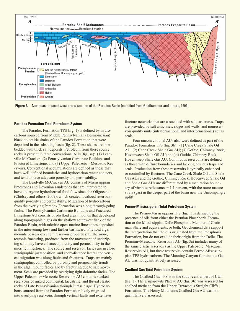
response to large intraplate stresses that have been attributed to the collision of Gondwana and Laurentia (Barbeau, 2003; Kluth and DuChene, 2009). The basin is asymmetric, with the deep-est part along the north margin, adjacent to the Uncompahgre uplift in Utah and Colorado (fig. 2). Interbedded salt and black shales were deposited close to the north basin margin, along with clastics shed off the Uncompahgre uplift. Penesaline and normal marine carbonates developed along the gently dipping southwest basin margin and interfingered with the salt and black shales.
MONTANA
WYOMING
COLORADO
UTAH
NEW MEXICOARIZONACALIFORNIA
IDAHO
NEVADA
105°W110°W115°W
45°N
40°N
35°N0 100 200 MILES
0 100 200 KILOMETERS
EXPLANATION
Paradox Basin ProvincePermo-Mississippian TPSCoalbed Gas TPSParadox Formation TPSSalt
A’
A
National Assessment of Oil and Gas
Figure 2. Northeast to southwest cross-section of the Paradox Basin (modified from Goldhammer and others, 1991).
Paradox Formation Total Petroleum System
The Paradox Formation TPS (fig. 1) is defined by hydro-carbons sourced from Middle Pennsylvanian (Desmoinesian) black dolomitic shales of the Paradox Formation that were deposited in the subsiding basin (fig. 2). These shales are inter-bedded with thick salt deposits. Petroleum from these source rocks is present in three conventional AUs (fig. 3a): (1) Lead-ville McCracken; (2) Pennsylvanian Carbonate Buildups and Fractured Limestone, and (3) Upper Paleozoic – Mesozoic Res-ervoirs. Conventional accumulations are defined as those that have well-defined boundaries and hydrocarbon-water contacts, and tend to have adequate porosity and permeability.
The Leadville McCracken AU consists of Mississippian limestones and Devonian sandstones that are interpreted to have undergone hydrothermal fluid flow since the Oligocene (Chidsey and others, 2009), which created localized reservoir-quality porosity and permeability. Migration of hydrocarbons from the overlying Paradox Formation was along through-going faults. The Pennsylvanian Carbonate Buildups and Fractured Limestone AU consists of phylloid algal mounds that developed along topographic highs on the shallow southwest flank of the Paradox Basin, with micritic open-marine limestones deposited in the intervening lows and farther basinward. Phylloid algal mounds possess excellent reservoir properties; furthermore, tectonic fracturing, produced from the movement of underly-ing salt, may have enhanced porosity and permeability in the micritic limestones. The source and reservoir facies are in close stratigraphic juxtaposition, and short-distance lateral and verti-cal migration was along faults and fractures. Traps are mainly stratigraphic, controlled by porosity and permeability trends in the algal mound facies and by fracturing due to salt move-ment. Seals are provided by overlying tight dolomite facies. The Upper Paleozoic−Mesozoic Reservoirs AU contains stacked reservoirs of mixed continental, lacustrine, and fluvial clastic rocks of Late Pennsylvanian through Jurassic age. Hydrocar-bons sourced from the Paradox Formation likely migrated into overlying reservoirs through vertical faults and extensive
fracture networks that are associated with salt structures. Traps are provided by salt anticlines, ridges and walls, and nonreser-voir quality units (intraformational and interformational) act as seals.
Four unconventional AUs also were defined as part of the Paradox Formation TPS (fig. 3b): (1) Cane Creek Shale Oil AU; (2) Cane Creek Shale Gas AU; (3) Gothic, Chimney Rock, Hovenweep Shale Oil AU; and( 4) Gothic, Chimney Rock, Hovenweep Shale Gas AU. Continuous reservoirs are defined as those with diffuse boundaries and lacking obvious traps and seals. Production from these reservoirs is typically enhanced or controlled by fractures. The Cane Creek Shale Oil and Shale Gas AUs and the Gothic, Chimney Rock, Hovenweep Shale Oil and Shale Gas AUs are differentiated by a maturation bound-ary of vitrinite reflectance = 1.1 percent, with the more mature strata (gas) in the deeper part of the basin near the Uncompahgre uplift.
Permo-Mississippian Total Petroleum System
The Permo-Mississippian TPS (fig. 1) is defined by the presence of oils from either the Permian Phosphoria Forma-tion or the Mississippian Delle Phosphatic Member of Chain-man Shale and equivalents, or both. Geochemical data support the interpretation that the oils originated from the Phosphoria Formation, but do not exclude their origin from the Delle. The Permian−Mesozoic Reservoirs AU (fig. 3a) includes many of the same clastic reservoirs as the Upper Paleozoic−Mesozoic Reservoirs AU, but these reservoirs contain Permo-Mississip-pian TPS hydrocarbons. The Manning Canyon Continuous Gas AU was not quantitatively assessed.
Coalbed Gas Total Petroleum System
The Coalbed Gas TPS is in the south-central part of Utah (fig. 1). The Kaiparowits Plateau AU (fig. 3b) was assessed for coalbed methane from the Upper Cretaceous Straight Cliffs Formation. The Henry Mountains Coalbed Gas AU was not quantitatively assessed.
Des Moinesian
Atokan
LimestoneDolomiteAlgal BiohermAnhydrite
GraniteHalite
Coarse Arkose Red Siltstone(Derived from Uncompahgre Uplift)
Figure 3a. Location of four conventional assessment units (AUs) in the Paradox Basin.
Figure 3b. Location of five continuous assessment units (AUs) in the Paradox Basin. TPS, total petroleum system.
Hypothetical Total Petroleum Systems
Two TPSs were recognized in the Paradox Basin that do not have any known resources and could not be quantitatively assessed. The Precambrian Chuar Group contains shales with up to 10 percent total organic carbon that could have generated technically recoverable hydrocarbons within the Precambrian Chuar Self-Sourced Reservoirs AU. The Devonian Aneth Formation is described as having black shale intervals and because the Devonian is one of the major source rock intervals worldwide (Klemme and Ulmishek, 1991), the formation is recognized as having some potential for technically recoverable hydrocarbons within the Devonian Self-Sourced Reservoirs AU.
oil and gas resources in nine assessment units in the Paradox Basin (table 1). Four conventional AUs were assessed to contain means of 89 million barrels of oil (MMBO), 833 billion cubic feet of gas (BCFG), and 18 million barrels of natural gas liquids (MMBNGL). Four unconventional AUs were assessed to con-tain means of 471 MMBO, 11,868 BCFG, and 472 MMBNGL. The Kaiparowits Plateau Coalbed Gas AU was assessed to con-tain a mean of 450 BCFG. The assessment was based on 2011 IHS well and production data (IHS Energy Group, 2011).
For Further InformationSupporting studies of the geologic models and the meth-
odology used in the 2011 Paradox Basin assessment are in progress. Assessment results are available at the USGS Central Energy Resources Science Center website: http://energy.cr.usgs.gov/oilgas/noga/.
References Cited
Barbeau, D.L., 2003, A flexural model for the Paradox Basin―Implications for the tectonics of the Ancestral Rocky Moun-tains: Basin Research, v. 15, p. 97−115.
Chidsey, T.C., Jr., Morgan, C.D., Eby, D.E., Moore, J.N., Taylor, L.H., and Humphrey, J.D., 2009, Diagenetic analysis of the Leadville Limestone, Lisbon case-study field, in Chidsey, T. C., Jr., ed., The Mississippian Leadville Limestone explo-ration play, Utah and Colorado―Exploration techniques and studies for independents: Final Report for DOE Award, no. DE-FC26-03NT15424, p. 4-1–4-20.
Gautier, D.L., Dolton, G.L., Takahashi, K.I., and Varnes, K.L., 1996, 1995 National assessment of United States oil and gas resources―Results, methodology, and supporting data: U.S. Geological Survey Digital Data Series DDS−30, Release 2.
Goldhammer, R.K., Oswald, E.J., and Dunn, P.A., 1991, Hierar-chy of stratigraphic forcing―Example from Middle Penn-sylvanian shelf carbonates of the Paradox Basin, in Franseen, E.K., Watney, W.L., Kendall, C.G.St.C., and Ross, W., eds., Sedimentary modeling―Computer simulations and methods for improved parameter definition: Kansas Geological Survey Bulletin 233, p. 361−414.
IHS Energy Group, 2011, PI/Dwights PLUS U.S. production data: Englewood, Colo., database available from IHS Energy Group.
Klemme, H.D., and Ulmishek, G.F., 1991, Effective petroleum source rocks of the world; stratigraphic distribution and controlling depositional factors: American Association of Petroleum Geologists Bulletin, v. 75, p. 1809−1851.
Kluth, C.F., and DuChene, H.R., 2009, Late Pennsylvanian and Early Permian structural geology and tectonic history of the Paradox Basin and Uncompahgre Uplift, Colorado and Utah, in Houston, W.S., Wray, L.L., and Moreland, P.G., eds., The Paradox Basin revisited―New developments in petroleum systems and basin analysis: Rocky Mountain Association of Geologists Special Publication – The Paradox Basin, p. 178−197.
Assessment TeamParadox Basin Assessment Team: Katherine J. Whidden
(Task Leader; [email protected]), Lawrence O. Anna, Krystal M. Pearson, and Paul G. Lillis.
Review Committee: Ronald R. Charpentier, Troy A. Cook, Timothy R. Klett, Richard M. Pollastro, Russell F. Dubiel, and Christopher J. Schenk.
Total undiscoveredoil and gas resources 254 519 1,007 560 6,429 11,915 21,623 12,701 225 451 891 490
[MMBO, million barrels of oil; BCFG, billion cubic feet of gas; MMBNGL, million barrels of natural gas liquids. Results shown are fully risked estimates. For gas accumula- tions, all liquids are included as NGL (natural gas liquids). F95 represents a 95-percent chance of at least the amount tabulated; other fractiles are defined similarly. Fractiles are additive under the assumption of perfect positive correlation. TPS, total petroleum system; AU, assessment unit. Gray shading indicates not applicable]
Table 1. Paradox Basin Province assessment results.