WOLVERINE Exploration ami (d Mineral RECEIVED OCT 252004 GEOSCIENCE ASSESSMENT OffICE 28646 Dave Hanes noo K emit Court Apt.iiO'6 Sudbury, Oimitanlo Cainijid.ai P 5) A 31M04NE2043 2.28646 SOUTH LORRAIN 010
Transcript
WOLVERINEExploration ami (d Mineral
RECEIVED
OCT 252004GEOSCIENCE ASSESSMENT
OffICE
28646
Dave Hanesnoo K emit Court Apt.iiO'6
Sudbury, Oimitanlo Cainijid.ai
P 5)A
31M04NE2043 2.28646 SOUTH LORRAIN 010
REPORT FOR ASSESSMENT
CREDIT ~ 200 4
SOUTH LORRAIN TWP.
PLAN G - 3448
MONTREAL RIVER CLAIMS
Authored by::
Dave Hainiag — Sudbury Qinu
Montreal River Claims - Wolverine Explorations - 2004
I Cover Page
Index
II Access and Ownership
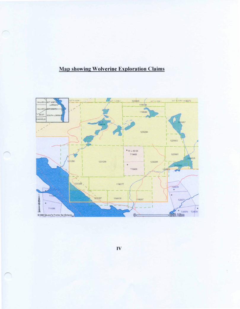
III Location Map and Access
IV Map - All Claims
Pages l to 9 Assessment Report 2004, Claims 1231288 and 1231290 (4 days field work)
Page 10 OPS Waypoints List
Pages 11 to 14 Photo Section
Page 15 Sample List
Pages 16 and 17 Assays Lab Sudbury
Page 18 Assessment Costs - 2004
In Pocket updated Map: WE - 2002 - l revised to WE - 2004 -l
Also Claim Map Dated October 23, 2004
Access and Ownership
Access:
From North Bay, travel North to highway H 11 B. Travel l IB through Cobalt to North
Cobalt. At north Cobalt take highway # 567, and drive a Southerly direction for about 29
km. where you will ( should ) see the South Lorrain Twp. Sign. At about 31 km. from N.
Cobalt you leave # 567, at the Road closed sign. Turn right here. Continue about
6.7 km., approaching the Montreal River. At this point, a rough road leads north through
Wolverine Exploration Claim 1198287and into the Windy Lake Claims of which DAVE
HANES is a partner. Following the old RR, you pass through Wolverine Exploration
Claims 1198178, 1231287, 1231288, and 1231290. Wolverine Exploration Claim
1231289 is a 4 unit claim lying north of the Montreal River.
Ownership:
Claims 1198287, 1198178 and 1231287 are single units of 16 Ha each, and held 10007o
by Wolverine Exploration.
Claim 1231288 is a single 16 Ha. unit, Claim 1231290 is a 2 unit claim and 1231289 is
a 4 unit claim held jointly. 500X0 each by Wolverine Exploration and Marlene Carr.
Montreal River Claims and Windy Lake Claims are contiguous group of claims
n
ACCESS TO WOLVERINE EXPLORATION Si WINDY LAKE CLAIMS
Frtim North Bav travel North lo tiiehwa* tt l \ B. Travel i i B ihmugh Cobalt m North C.iball. M Nonh Cobalt lake high"~ai S 5h~. and drive a Suuihcrty Jirection fur ahoul 29 km. where wiu ivill i should - see Ihc South Lorrain Twp sign. \i ab.iui 31 km. from Y Cututll you leave a 56?. at the Road closed ugn. Turn right here. Continue iihoui IT."" km., appnmchmt* the Montreal River/ Al this pwmi is. a narnm rough lot&in^ mad IcadinR Nonh ihmugh \Vnlvenne Daim l !^H28?.
This Claim coven uccess m claims held m partnership In mvsclf, i Dive Hanes i . James, MacLtchlan and Sherwood Plunkctt. FoJImvmg chis rou^h nwd IH>rthcri^. you pans through Claim l 1981— and inni Claim 123112"*? ^ \hnn distance Nonh is ;i [unciion Jnd J narniw mad leading Eaii jiasi j Beaver pond.
By staving on the mam road north, you pass .mi of Claim 12302'*^ and l h mug h a corner .if Claim 122*^12 jnd mid Clmm 1221*"OI. \: the north end .m a down "radc, iiiu osii Claim 1229901 and into mirth cast corner of Claim :i3H-'*5 lor a sh*m distance m j dear cut and inlti Claim 11302^4 ^biHil 300 mcicn north (hi
ad ends, where it crnssc-. a bulldozed poniun of an Olivine Di a li a w FKke
•Vrndy Lake
JL
Map showing Wolverine Exploration Claims
_—-— ̂ i— -— ™^r.™^ ̂ ———.
ixsn Taobo
IV
Assessment Report - Montreal River Claims - 2004
October 16, 2004
For the year 2004, the majority of my time has been spent promoting the Windy Lake
Claims in South Lorrain Twp., Wolverine Claims east of Sudbury and projects for other
clients.
This time period - September 24 to September 28, 2004 is going to be all the time
available to work on Claims that are due October 26 and November 3, 2004.
Friday, September 24 Dave Hanes and partner Marlene Carr drove from Sudbury to
South Lorrain - Silver Centre. Because of bad roads (flooded and washout) we decided
to camp at Four Claim Lake. This is about 4 miles from the Claims.
We unloaded the ATV and drove to a spot near the old Adit on the Montreal River. It
is about 9:00 AM and I plan to prospect the area north of the old RR and 2 old pits at the
base of a 20+ meter vertical ridge of Nippising Diabase.
The area we prospected is very heavily overgrown with large pine, spruce, birch and
poplar. It appears logging has not been done for many years. Scattered throughout the
forest are burnt out, large pine stumps, testament to a fire that raged through this area
about 1919. Although we have located the old adit, (flooded by the damning of the
Montreal River), we can only guess as to the approximate area of the Diamond Drill Hole
put down in the mid 1920's by Norbay Silver.
The cross fault that cuts across the Montreal River on the old Lamprecht property,
Pg.l
through the adit (east shore) appears to split into several north, north east trending ridges,
striking towards the old Norbay Shaft on Wolverine Exploration Claim No. 1198178.
We examined the Nippising Diabase on many of the "steps" up to the top of the dome,
being some 100+ feet above the old RR.
The Diabase is very inconsistent in nature, ranging from fine grained to a very coarse
grained rock with elongated amphibole (hornblende) xls. Although the Diabase is
loosely termed Quartz Diabase, it is well mixed and contains only minor disseminated
sulphides.
What we are prospecting for is larger veins of calcite, quartz in proximity to faults and
fracture zones.
Fracture filling is common in Silver Centre where Silver - Cobalt veins have been
mined in the early - mid 1900's.
We have located only one such vein — in the crosscut at the bottom of a deteriorating
shaft put down by Norbay. We have not pursued this vein as the shaft in such a
hazardous condition. This shaft though, appears to have been put down on a minor fault
zone, following a ridge downward approximately 20 feet where 2 Crosscuts were cut on
weathered Nippising Diabase.
We did locate several old trenches and mostly filled in pits today and collected some
samples to clean and examine for possible Assay.
About 5:30 PM we drove back to Four Claim Lake as we still had camp to set up.
Work today was confined to a portion of Claim No. 1231288.
Pg.2
Saturday September 25,2004
Early breakfast and out to the west end of Claim 1231290, which has the No. 3 post
near the timber bridge on a small creek which drains the upper end of the Wolverine
Claims and the northern Windy Lake Claims.
Very surprising is the creek bed which is almost bone dry. Following the creek bed
northward we noted many types of boulders in the narrow ravine which makes up the
south end of the creek Every size and shape can be seen and this boulder train is several
meters deep in places and, if you listen carefully you can hear trickling water far beneath.
Much of the boulder strewn creek is composed of rock not found locally, being
deposited by glaciations thousands of years age and possibly from hundreds of miles
distant. It is hard to determine if this gorge is part of a N S minor fault which is now the
resting place for possibly millions of tons of boulders. We examined limited exposures
along the shores of the creek finding one small band of Nipissing Diabase the balance
being an impure dirty Lorrain Formation Quartzite, mainly brownish with much mica
inclusions.
Above the gorge to the dry waterfalls, the area "flattens" east and west of the creek.
Here we enter an area of boulders, almost like a very large fan spreading outwards,
northerly away from the waterfalls.
This is a tricky area to traverse as the boulders are covered with moss and holes
between that can break a leg if you aren't careful.
I had hoped to locate the western extension of the Olivine Dyke which is exposed
eastward on the Windy Lake Claims and strikes S - SW from Windy Lake and Map 2194
Pg.3
indicates a projected line exiting out of Wolverine Exploration Claim No. 1231290. I am
convinced this dike is irregular in its direction and may be overlain by Nipissing Diabase,
(which it cuts on Claim No. 1230294) and Lorrain Formation Quartzite on its western
end.
A Magnetometer survey may have to be completed to pick up this dyke beyond (west)
our survey on the eastern Windy Lake Claims.
Some maps indicate our area of travel along (Northward) the creek to the beaver ponds
as being part of the Windy Lake Fault. This is a very well defined Fault west of Windy
Lake as it cuts through Windy Lake Claim No. 1198286. The north wall, vertical rises
some 30+ meters with a 10+ meter interval of broken Diabase and a more rounded, lower
south wall.
Near the Old South Keora Camp remains, the area west opens into a vast gently sloping
valley with more S — SW with high vertical ridges visible and much old trenching and
pits.
We have not as yet located the old 1920's Keora Shaft, reported to be at least 75 feet
deep.
I have not seen any rock that would require collecting samples. Further N - NE is an
area of Granophyre which may contain gold grains as indicated in till samples collected
while working in 2002 on a Keating Anomaly project.
To get back to the ATV, I decided to get away from the "creek" westward and follow
the N S claim line back to the Hydro Bridge on the old RR.
Work today was mainly on Wolverine Exploration Claim No. 1231290.
End of Day 2. Pg.4
The next two days were spent on the central to eastern boundary of Claim No. 1231290.
We are going to prospect and map an area, westward of an old pit on the joint NS claim
line of 1231289 and 1231290.
My last trip in this area was almost 2 years ago after collecting samples of rocks in and
around the old pit on the claim line (NS). Returning to the road I had noted several
trenches and a large pit. At the time, late in the day and my pack full I had taken a OPS
position for future prospecting.
Sunday September 26, 2004
Just east of the bridge the ATV was parked out of site in the bush. Taking food, water
and hammers etc. we climbed to the top of the hill northward to an area of glaciated
Lorrain Formation Quartzite.
We need to have a starting point so I used my OPS and located the position for the old
pit. From here we worked westward, down a low grade and located some old trenching.
Unfortunately many of these old trenches, pits date back some 75 - 80 years and have
been overgrown and partially overburden filled. Although still clearly visible, it is very
time consuming and hard work to dig into these trenches to locate walls or bottom of
trenches.
For the most part, especially in open areas and no exposures or outcrops in the
immediate area these trenches would be opened up because of the use of a dip needle.
These trenches were put down on iron rich anomalies which appear to be well beyond the
surface trenching.
Pg.5
Our interest in working in the old trenches is to possibly locate sulphides and or Ag.
There is also the chance we may locate other rock types other than the Nipissing
Diabase that the Nipissing Diabase dome is comprised of. This has been the case in our
past prospecting throughout the Windy Lake and Montreal River claim groups.
Example, the Aplite dyke on a wall of the old pit just east of here on the joint NS line.
The first group of trenches provided no exposure of bedrock, only broken rubble which
may or may not have been removed from trenching into bedrock.
A short distance east there is a ridge 2+ meters high and a trench running into the base
of it. The ridge is comprised of fine grained Nipissing Diabase. The trench, which has
been cut through bedrock, is about 5 meters long. Rock broken off the walls is different
than any rock on our claims that we have prospected to date.
The rock is banded, being thin bands of grey blue quartz and an almost black material
in bands. These bands alternate and are quite uniform. A sampled was collected mainly
for ID., could be banded ironstone?
See Sketch Map and Photo Section.
OPS positions have been recorded and updated sketch map for trenching, pits
prospected today.
As it is late in the day, it is time to pack and label our samples and return to camp. We
only have one more day and it is slow going because of thick forest cover and
overburden. The area we are prospecting needs about 2 weeks early in spring before the
leaves are on the trees.End of day 3.
Pg.6
Monday September 27, 2004
Today we returned to the area prospected yesterday. Starting where we left off, several
more trenches were examined as well as several exposures in the area.
For the most part, Nipissing Diabase is the main bedrock, coarse and medium grained
minor sulphides observed.
One trench, approximately 35 meters long (NS) with a connecting trench running
E - W some 45 meters long is quite extensive. It opens into pit like excavation in several
spots along its 2 directions. These 2 trenches range from 1-3 meters in depth.
Interesting samples were collected on a wall (pit) consisting of a dark grey material
with irregular veining of discolored quartz. Good concentrations of sulphides were
observed. Again, the best samples collected today were non Diabase origin possible pods
or small dykes. The Diabase for the most part has shown very little in the way of
minerals of interest (Ag. - Sulphides).
At this time it is not possible to locate the boundaries or contacts between the Nipissing
Diabase and the different rock type's encountered ad sampled. Our present mapping and
sampling will be a basis to study and then possibly concentrate and open up the most
promising areas in the future.
We examined a couple more trenches which strike EW, running up a fairly steep grade
on Nipissing Diabase. It is now about 4:30 PM and I want to take a quick look at a large
pit and trenching a little further north (about 25 meters) before heading back to camp.
Pg.7
Arriving at the OPS position previously plotted, I realized we would not have time to do
a proper examination and prospect the area as there are other trenches and exposures in
the immediate area.
From my OPS position and plotting on a map, it appears there is an east - west series
of pits and trenches, several containing rock types other than the Nipissing Diabase of
the Dome which strikes mainly N - to slightly NE after it crosses the Montreal River.
This dome rises from 100 - 150 + feet above the river. The Diabase is well exposed on
both sides of the River.
South of the PIT on the joint claim line (NS) there is an old trench cutting the line.
Both east and west there is the remnants of what seems to be the old road that would
access the work area and following it eastward may bring us to other old workings.
With samples packed and labeled we walked out to the ATV. This takes about 30 to 45
minutes as the south end of the claim is extremely rough (slide areas) thick brush and bad
footing on the moss covered, glaciated Quartzite.
We arrived back at camp about 6:30PM. Tomorrow (Tuesday) we will pack and head
back to Sudbury.
See Sketch Map(s) and Photo Section
End of Day 4
Note: Of the 10 samples collected during field work, only 2 were submitted for Assay at
the Geo Lab in Sudbury. One of these was an unusual, very coarse Nipissing Diabase
Pg.8
with inclusions of an orange red material and sulphides, (sample 288 - 04 -1)
All samples were cleaned and examined and as the Nipissing Diabase is so similar to
samples assayed in past years, it is decided not to spend the money on Assays that will
probably return similar results.
End of fourth day
Pg.9
GPS List
Wpt 518 N 47 13 .035 Bridge near No. 3 Post, Claim 1231290 W 079 34 .613
Wpt 520 N 47 13 .081 Trenches - Banded Quartz and possibly ironstone W 079 34 .393
Wpt 521 N 47 13 .087 Short 16 meter trench - strike N-S overgrown W 079 34 .389 minor metafiles
Wpt 522 N 47 13 .114 East end of connecting trench to wpt 523W 079 34 .449 Sampled - dark fine grained material, visible
sulphides
Wpt 523 N 47 13 .125 North end of 35 meter trench W 079 34 .479
Wpt 525 N 47 13 .080 Single 10 meter long trench strikes W 079 34 .523 SW 240 degrees
Wpt 160 N 47 13 .080 (Now 290 - PT) Large pit and trenching not W 079 34 .408 examined yet.
Wpt-PIT N 47 13.100 On joint claim line 1231289 and 1231290. W 079 34 .291
Pg.10
Photo
Section
Pg.ll
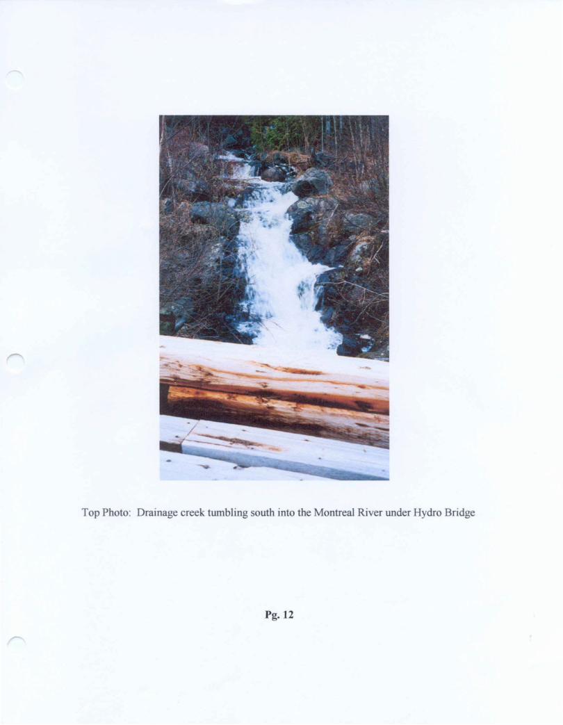
Top Photo: Drainage creek tumbling south into the Montreal River under Hydro Bridge
Pg.12
Top Photo: Dry spell 2004 - Waterfalls at head of creek draining many Beaver Ponds.
Bottom Photo: Looking south across beaver pond, I st of many. Exposed low lying Lorrain Formation Quartzite through a large valley while east is the massive Nipissing Diabase Dome.
Pg-13
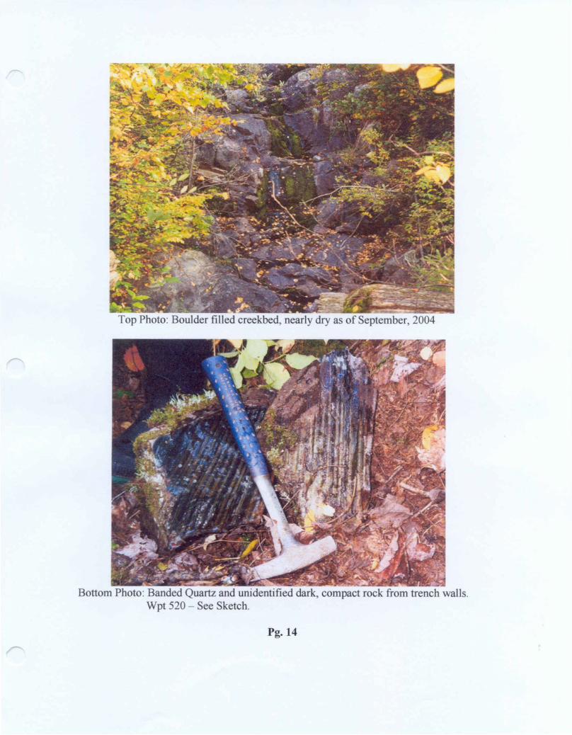
Top Photo: Boulder filled creekbed, nearly dry as ol" September, 2004
Bottom Photo: Banded Quartz and unidentified dark, compact rock from trench walls. Wpt 520 - See Sketch.
Pg-14
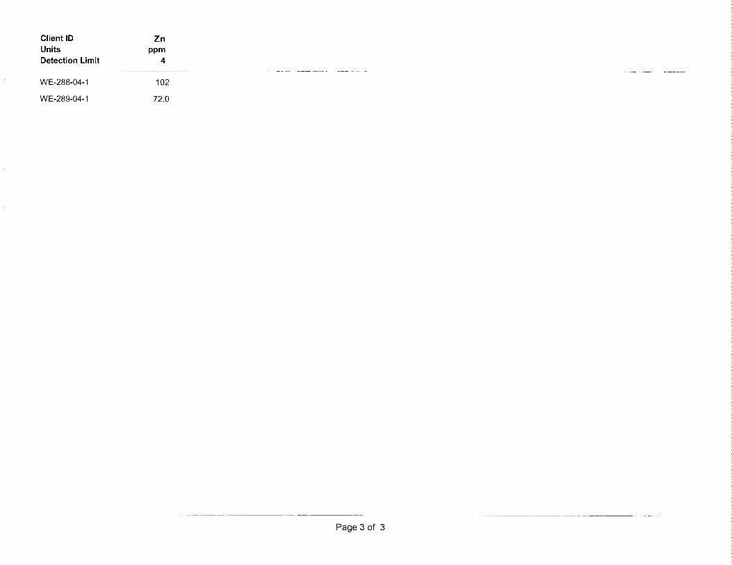
Samples Submitted to Geo Lab, Sudbury for Ag and Base metal Assay
288 -04-1 Coarse grained Nipissing Diabase. Trench above old RR and Nor Adit. Sulphides visible. Geochem - Ag - Cu - Co - Ni - Zn
289 -04-1 Very hard, compact, grey black quartz veining, sulphides in quartz and host rock.
8 other Samples collected were mainly Coarse - Medium grained Nipissing Diabase.
See Report for details.
Pg.15
Assays
Pg.16
Assays
Pg.17
Assessment Costs
Sept. 24, 2004 Dave Hanes and Marlene Can-Prospect - Sample north of RR & Montreal Riverl day @ 2 x S 1 50.00 — — — — — — — — — — -— — ^ S300.00
Sept. 25, 2004 Dave Hanes and Marlene Can-Prospect north to waterfalls along creekl day @ 2 x S150.00 — — — — — — — — — — — — - = S300.00
Sept. 26, 2004 Dave Hanes and Marlene Can-Prospect - Map, collect samples Claim 1231290l day @ 2 x S150.00 ~~——— ~——~ — ~~~— ~ - S300.00
Sept. 27, 2004 Dave Hanes and Marlene CanContinue prospecting, mapping and sample area aroundprevious days workl day @ 2 x S 1 50.00 — -— — — — — — — — — — — = S300.00
Transportation - Round Trip - 500 km x S0.40 km. — — — — — — — — - = S200.00
Use of ATV includes fuel 4 x S30.00 — — — — — -— — — — — — — — = S120.00
Misc. Sample bags, flag tape - Photos, file folders ———————————— = S 15.00
Clean, examine and select 2 samples out of 10 for Assay.Pack, label and deliver to Geo Lab Sudbury 5hrs @ S 10.00 — — -^ S 50.00
Assays 2 Samples ————— —--———— ————— —-——-— = S 100.00
Dave Hanes - Prepare rough draft of Report and complete Sketch Maps7hrs. xSlS.OO -— — — — — — — — — — — — — — — - = S105.00
Marlene Carr - Compile and type final copies (3) of assessment Reporton Computer 5hrs. x S 1 5.00 — — — — — -— — — — -- = S 75.00
Total Assessment = S2,065.00
Pg.18
Ontario
CERTIFICATE OF ANALYSIS
GEO LABSGEOSCIENCE LABORATORIES
Geoscience Laboratories (Geo Labs)
933 Ramsey Lake Road, Bldg A4
Sudbury, ON P3E 685
Phone: (705) 670-5637
Toll Free : 1-866-436-5227
Fax: (705) 670-3047
Issued To : Mr. D Hanes
Wolverine Exploration and Minera
100 Kent Court Apt. #106
Sudbury, ON P3A 4R5 Canada
Phone: 705-560-7376
Fax : -
: E-Mail: -
i Client No. : 323
Method Code reported with this certificate : GFA
Method Code Description
Certificate Date : 10/28/2004
Certificate No. : 15839
Project Number : n/a
Geo Labs Job No. : 04-0329
Submission Date : 10/07/2004
Delivery Via : MAIL
QC Requested : NO
Qty Status
GFA
IA-100
Gravimetric Fire Assay
ICP-AES
2 COMPLETE
2 IN PROG
Legend:
N.D.s Not detectedN.M. - Not measured
Please refer to Geo Labs Job No. 04-0329 if you have any questions.CERTIFIED BY
Date:
Ed Debicki, Laboratory Manager
J f,
Except by special permission, reproduction of these results must include any qualifwg remarks made by this Ministry with reference to any sample. Results are for samples as received.
CLIENT: Hanes Geo Labs JOB # : 04-0329 DATE : 10/28/2004 METHOD CODE : gfa
Client ID Units Detection Limit
WE-288-04-1
WE-289-04-1
Agoz/ton
0.1
N.D.
N.D.
GEOSCIENCE LABORATORIES CERTIFICATE OF ANALYSIS GEO LABS
GCO5CIENCE LABORATORIES
Page 1 of 1
Ontario
CERTIFICATE OF ANALYSIS
GEO LABSGEOSCIENCE LABORATORIES
Geoscience Laboratories (Geo Labs)
933 Ramsey Lake Road, Bldg A4
Sudbury, ON P3E 6B5
Phone: (705) 670-5637
Toll Free : 1-866-436-5227
Fax: (705) 670-3047
Issued To : Mr. D Hanes
Wolverine Exploration and Minera
100 Kent Court Apt. #106
Sudbury, ON P3A4R5 Canada
Phone : 705-560-7376
j Fax : -
E-Mail : -
Client No. : 323
Method Code reported with this certificate : IA-1 00
Method Code Description
G FA
IA-100
Gravimetric Fire Assay
ICP-AES
Certificate Date : 11/30/2004
Certificate No. : 16021
Project Number : n/a
Geo Labs Job No. : 04-0329
Submission Date : 10/07/2004
Delivery Via : MAIL
QC Requested : NO
Qty Status
2 COMPLETE
2 COMPLETE
Legend:
N.D^ Not detected
N.M. = Not measured
Please refer to Geo Labs Job No. 04-0329 if you have any questions.CERTIFIED BY
Date : A/ o ~j-^ -r* "-''
Ed Debfefci, Laboratory Manager
Except by special permission, reproduction of these results must include any qualifing remarks made by this Ministry with reference to any sample. Results are for samples as received.
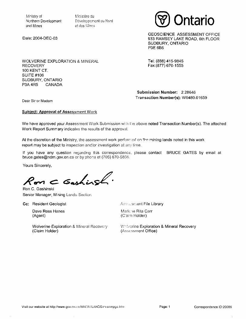
We have approved your Assessment Work Submission with the above noted Transaction Number(s). The attached Work Report Summary indicates the results of the approval.
At the discretion of the Ministry, the assessment work performed on the mining lands noted in this work report may be subject to inspection and/or investigation at any time.
If you have any question regarding this correspondence, please contact BRUCE GATES by email at [email protected] or by phone at (705) 670-5856.
Yours Sincerely,
Ron C. GashinskiSenior Manager, Mining Lands Section
Cc: Resident Geologist
Dave Ross Hanes (Agent)
ARR';..sment File Library
Marlcne Rita Carr (Claim Holder)
Wolverine Exploration S Mineral Recovery (Claim Holder)
Wolverine Exploration 8c Mineral Recovery (Assessment Office)
Visit our website at http://www.gov.on.ca/MNDM/LANDS/mlsmnpge.htm Page: 1 Correspondence ID:20086
TW*a *ii(*iflto*Wton*^aftWW* thoijW eoiwjlt wsh It* f>*^v*cl•l UWnj awoKWn* on** 01 ID* MIMrtiy w MWIh*fB Dwmlepnivnt MM Thto imp M not InMndwt lei nnv*BSt)or*s, Mjn*y, w land IBIS aniwirtnMW pL*pt*o* M in* ttnwntrtkin •howl on tKto mipbcanvIM ttam va hMimilbn nnv *ko ta oblalmt IttKWg!) If* tocal U)nd T*tas w RaQtatry CTfta, O( tti* MlnMry o( Matudl nnioufMS.
* hw *MKbn*l twonwtten on Ik* tGeneral Information and Limitations
n Mltol cuntai Qll Ratwoy ia*e ( iM Dtu Sotnca: U)M IrtcwnaMan CWMrb
TM* ntp my na4 ifww WMgltwrtd MM tenuw 1M HfMMM* m hM IndudlnB Mi •SMfmnt*. hQKIM w*vo, (leodWfl MqMt, Hc*nMA. Blollwr Fotn* (XdktvMHtenol i CMvm *uot*italn toM I*n0f*ana HM UM* Mwl WKWKI M mohMill ri**BiMfv w bo Muelralod.
Date y Time of Issue: Wed Dec 01 16:30:08 EST 2004
TOWNSHIP l AREA PLAN SOUTH LORRAIN G-3448
ADMINISTRATIVE DISTRICTS l DIVISIONS
Mining Division Larder LakeLand Titles/Registry Division TIMISKAMINGMinistry of Natural Resources District NORTH BAY
TOPOGRAPHIC Land Tenuref iMhadJ Pilonl
tK Ana Mtwtis Btgf*i
nn
Laasshold Patent
Surtax And Mtn^g FH
a cs m aB
Sinaca Ana Mmmg Right*
SurfacofltttltsOnlv
Unduml^irmD
WMli PMVr LBHH AgnHnnBnt
XnlnBCIWn
niM only Mining cull f 1334Mk™-~.
LAND TENURE WITHDRAWALS
1XM Araae WittidmMt tom DlspotWon
IMPORTANT NOTICES
LAND TENURE WITHDRAWAL DESCRIPTIONS
Wwn Jan 1,3001 FLOOWN6 EtEVATIOf* *9 5.00 FT HLE: 1353B7Warn Jan 1, 200) RESERVATION OF O ME CHAIN r ROM Ml OH WATER MARK TO K MADE ON A
PATENTS Or LANDS BORDCWNO ON LAKE TIMISKAMING, EFFECTIVE FEBR1938
W*m J*n 1,2001 400FT SURTAOE WOMTS RESERVATION ALONQ THC SHORES OF AU LAKESRIVERS
Warn Apr a , 20W CM Utta Ctmatvolton (V*ormW* Jut 37,2004 fjM . M W-t-BO-0* S.R.O. 3004/07/2? 1S5150 W* S*p IT. 19B6 SBCW-L-SI/M NCR SIPT 1J/S6 SRO 1M32T Wa Gap 17. 1396 W-l-SJ/fK N6R SEfT.IT/E* SRO TOWER SITE DUCK HABITAT Warn Fnfc 15, 200! 8oc.4BMn.r5 enf Surtaco rtjhtaFt*. l EL 20Ce 1*0190Wem G*p17, 1996 S6C3HWW-OMt-S3-'96 GEPT 17/86 W* S - ItellM, INI uHMmmDl *HI fat new b
ragutoitd an Cofw*tvjitm Rmwrvo, corwufi (hsMlnlno Rucontcrv Otlta IdrlM ng
2.28646 ASSAY PROSP
South Lorrain Twp.Plan - G -344g ^ 4
MONTREAL RIVER CLAIMS Wolverine Exploration A Marlene Carr
Map showing Claim 1231288 and Claim 1231290. Contained arc the old RR ( now rough road ), flic shore of the Montreal River and previous Norbay ( 1920's) workings.
Trenches, pits and an adit cut into the cliff on the river are plotted hereon by using GPS coordinates, thus giving a reliable and accurate placement of prominent features. The stream, draining ponds to the N - NW is shown also. Tied into lines inland are other old exploration work, ( possibly South Keora X most notably a pit on the south side of a steep gully on die joint Claim 1231289 and Claim 1231290. Samples collected here show a variety of rock types. See Report: A list of samples, Assays and locations are within the 2002 Assessment Report.
Relevant GPS and Way point No's are shown in the Report and can be cross referenced with corresponding map no's Le. .058.
The main percentage of these claims are Nipissing Diabase with contact to Lorrain Formation Quartzites.
The Diabase dipping under the overlying sedimentary rocks. Still, to be determined by future prospecting is the location of the Windy Lake Fault A dyke which traverses claims to the N - NE has been located on the western edge of Claim 1231289 *nd we wil attempt to trace it eastward across this claim.
1231270
Small drainage creek from ponds north -North-East Substantial flow in spring and heavy rain.3 - 5 m high waterfalls on ridge of mainly sedimentary rocks. Ridge isapprox. 25 metres wide in an E - Wdirection.
Stream tumbles S - SW from pond to Montreal River, a distance of approx. 340 metres. *-\
Old pit am side of Nipissing Diabase iilL Several rock type* exposed both within the pit and above. "Possible" dyke on east * south wall
exposed. Similar to "lamprophyre or Konberiite*See Report
. 03ft - .045, old pits and Nipissing Diabase Cliff
934 Mixed rocktypes - slide area.
. 035 Start of exposed Nipissing Diabase SilL
036 Broken masses of Nipissing Diabase at mouth of Adit, also location of crossfault which is a continuation of Lamprecht fault across river. See Photos.
068 Blasted Nipissing Diabase. Previously mapped as old Norbay Adit ( 2O01)
Boulder train approx. 10 m wide, l various fine*, possibly old creek bed. •j tft/.t^r -Hll mwlc thic mote inWater still travels this route in
extremely wet conditions.
, \ Glaciated Lorrain Formation Quartzite, much open exposures with thin overburdencarrying mixed bush.
Glacier broken sedimentaryoouderbroken from cliff and covering approx. 30 m along bottom of exposed cliff.
^
^
^
4?
X.**
1?
Location of the N - NE trending Windy Lake Fault b not shown on this map. There are 3 possible positions for this Fault whkh intersects the Montreal River Fault along the shore of Montreal River. Maps aad Reports (old A new) show different locations for the Windy Lake Fanh. Locating the old South Keora Shaft to the N - E of this map area could assist and, following "apparent* faults aaid fracture zones S - SW could confirm location.
MONTREAL RIVER FAULTN-NW
MONTREAL RIVER
. f o i too i/OD m.
Scale: 1:2,000 l cm. - 20 m.
MAP : WE - 2002 -
Drawn by Dave Hanes Wolverne Exploration Dec. - 2002
1178177
cafeV*̂ st**rf*̂
Nipissing Diabase Cliff 15-25 m in heigh
Old Norbay Adit (SetReportA Photos ) ' 'S
Island (now submerged) D. D. cut Ag. in Nipissing Diabase
Sand b day ridge, contacting base of exposed Nipissing Diabase Cliff.
Sand cliff - 20 - 25 m high with exposures of gray clay.
\Q#A*
W*- 'S^J^^
•/^l^*X'e-tr*-\
* Ravine, Glaciated rubble from Nipissing Diabase SilL Football size to boulders of many tons.


![[Paul lorrain] solutions_manual_for_electromagneti(bookos.org)](https://static.documents.pub/doc/80x56/55966d8a1a28abd9748b46b6/paul-lorrain-solutionsmanualforelectromagnetibookosorg.jpg)


