26 August 2020 ASX Announcement FURTHER HIGHLY ANOMALOUS GOLD RESULTS AT MELROSE PROJECT Mapping and Targeting Studies Underway Highlights • Aruma has identified further highly anomalous gold mineralisation at the Melrose Gold Project in the Pilbara region of WA • Results come from two new licence - ELA08/3244 and ELA47/4414 • ELA08/3244 hosts 0.5m-wide quartz veins assaying up to 1.74g/t Au • ELA47/4414 has rock chip assays grading up to 0.36g/t Au • Gold anomalies on structure with Northern Star's Belvedere Prospect • Conductivity and Mapping studies underway to define alteration and mineralisation Aruma Resources Ltd (AAJ) is pleased to announce further highly anomalous gold results at the Company’s Melrose Gold Project in the Pilbara region of Western Australia. The Melrose Project is situated on the southern edge of the Pilbara Craton, adjacent to Northern Star Resources’ (ASX: NST) Paulsens Gold Mine and the Belvedere Deposit. Figure 1: Melrose Project area (yellow outlined) with new licences with highly anomalous quartz veins adjacent to Northern Star’s Belvedere Prospect. ASX: AAJ Capital Structure 1,139M Shares on Issue 75M Options on issue Board of Directors Non-Executive Chairman Paul Boyatzis Managing Director Peter Schwann Non-Executive Director Mark Elliott Company Secretary Phillip MacLeod Yilgarn Gold Projects SLATE DAM TROJAN RESOURCE SCOTIA SOUTH Pilbara Gold Projects MELROSE SALTWATER NSW Gold Project CAPITAL Head Office Level 1, 6 Thelma Street West Perth, WA 6005 T +61 8 9321 0177 F +61 8 9226 3764 E [email protected]W www.arumaresources.com Postal Address PO Box 152 West Perth, WA 6872 ABN 77 141 335 364 For personal use only
Transcript
26 August 2020
ASX Announcement
FURTHER HIGHLY ANOMALOUS GOLD RESULTS AT
MELROSE PROJECT
Mapping and Targeting Studies Underway
Highlights
• Aruma has identified further highly anomalous gold mineralisation at
the Melrose Gold Project in the Pilbara region of WA
• Results come from two new licence - ELA08/3244 and ELA47/4414
• ELA08/3244 hosts 0.5m-wide quartz veins assaying up to 1.74g/t Au
• ELA47/4414 has rock chip assays grading up to 0.36g/t Au
• Gold anomalies on structure with Northern Star's Belvedere Prospect
• Conductivity and Mapping studies underway to define alteration and
mineralisation
Aruma Resources Ltd (AAJ) is pleased to announce further highly
anomalous gold results at the Company’s Melrose Gold Project in the
Pilbara region of Western Australia.
The Melrose Project is situated on the southern edge of the Pilbara
Craton, adjacent to Northern Star Resources’ (ASX: NST) Paulsens Gold
Mine and the Belvedere Deposit.
Figure 1: Melrose Project area (yellow outlined) with new licences with highly
anomalous quartz veins adjacent to Northern Star’s Belvedere Prospect.
The following data is in relation to Historic rock chip data in the announcement and the individual holes are listed in the relative Minedex A Report number.
Criteria JORC Code explanation Commentary
Sampling techniques
• Nature and quality of sampling (e.g. cut channels, random chips, or specific specialised industry standard measurement tools appropriate to the minerals under investigation, such as down hole gamma sondes, or handheld XRF instruments, etc.). These examples should not be taken as limiting the broad meaning of sampling.
• Include reference to measures taken to ensure sample representivity and the appropriate calibration of any measurement tools or systems used.
• Aspects of the determination of mineralisation that are Material to the Public Report.
• In cases where ‘industry standard’ work has been done this would be relatively simple (eg ‘reverse circulation drilling was used to obtain 1 m samples from which 3 kg was pulverised to produce a 30 g charge for fire assay’). In other cases more explanation may be required, such as where there is coarse gold that has inherent sampling problems. Unusual commodities or mineralisation types (e.g. submarine nodules) may warrant disclosure of detailed information.
• Rock samples were taken and width, rock types and presence of sulphides noted.
• Location and date were recorded with sample descriptions.
• The type of sampling was rock chip and quartz vein sampling.
• The quartz veins were sampled across the vein and the width noted
Drilling techniques
• Drill type (e.g. core, reverse circulation, open-hole hammer, rotary air blast, auger, Bangka, sonic, etc.) and details (e.g. core diameter, triple or standard tube, depth of diamond tails, face-sampling bit or other type, whether core is oriented and if so, by what method, etc.).
• No drilling is reported in this announcement
Drill sample recovery
• Method of recording and assessing core and chip sample recoveries and results assessed.
• Measures taken to maximise sample recovery and ensure representative nature of the samples.
• Whether a relationship exists between sample recovery and grade and whether sample bias may have occurred due to preferential loss/gain of fine/coarse material.
• No drilling is reported in this announcement
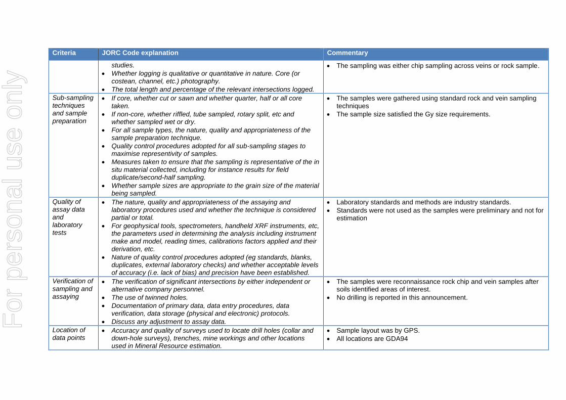
Logging • Whether core and chip samples have been geologically and geotechnically logged to a level of detail to support appropriate Mineral Resource estimation, mining studies and metallurgical
• All samples were logged geologically and qualitatively with the field description in the report
For
per
sona
l use
onl
y
Criteria JORC Code explanation Commentary
studies.
• Whether logging is qualitative or quantitative in nature. Core (or costean, channel, etc.) photography.
• The total length and percentage of the relevant intersections logged.
• The sampling was either chip sampling across veins or rock sample.
Sub-sampling techniques and sample preparation
• If core, whether cut or sawn and whether quarter, half or all core taken.
• If non-core, whether riffled, tube sampled, rotary split, etc and whether sampled wet or dry.
• For all sample types, the nature, quality and appropriateness of the sample preparation technique.
• Quality control procedures adopted for all sub-sampling stages to maximise representivity of samples.
• Measures taken to ensure that the sampling is representative of the in situ material collected, including for instance results for field duplicate/second-half sampling.
• Whether sample sizes are appropriate to the grain size of the material being sampled.
• The samples were gathered using standard rock and vein sampling techniques
• The sample size satisfied the Gy size requirements.
Quality of assay data and laboratory tests
• The nature, quality and appropriateness of the assaying and laboratory procedures used and whether the technique is considered partial or total.
• For geophysical tools, spectrometers, handheld XRF instruments, etc, the parameters used in determining the analysis including instrument make and model, reading times, calibrations factors applied and their derivation, etc.
• Nature of quality control procedures adopted (eg standards, blanks, duplicates, external laboratory checks) and whether acceptable levels of accuracy (i.e. lack of bias) and precision have been established.
• Laboratory standards and methods are industry standards.
• Standards were not used as the samples were preliminary and not for estimation
Verification of sampling and assaying
• The verification of significant intersections by either independent or alternative company personnel.
• The use of twinned holes.
• Documentation of primary data, data entry procedures, data verification, data storage (physical and electronic) protocols.
• Discuss any adjustment to assay data.
• The samples were reconnaissance rock chip and vein samples after soils identified areas of interest.
• No drilling is reported in this announcement.
Location of data points
• Accuracy and quality of surveys used to locate drill holes (collar and down-hole surveys), trenches, mine workings and other locations used in Mineral Resource estimation.
• Sample layout was by GPS.
• All locations are GDA94
For
per
sona
l use
onl
y
Criteria JORC Code explanation Commentary
• Specification of the grid system used.
• Quality and adequacy of topographic control.
• The rock sample locations were recorded and plotted for verification
Data spacing and distribution
• Data spacing for reporting of Exploration Results.
• Whether the data spacing and distribution is sufficient to establish the degree of geological and grade continuity appropriate for the Mineral Resource and Ore Reserve estimation procedure(s) and classifications applied.
• Whether sample compositing has been applied.
• The spacing was done to look a previous geochemical anomaly and identify bedrock where it looked promising.
Orientation of data in relation to geological structure
• Whether the orientation of sampling achieves unbiased sampling of possible structures and the extent to which this is known, considering the deposit type.
• If the relationship between the drilling orientation and the orientation of key mineralised structures is considered to have introduced a sampling bias, this should be assessed and reported if material.
• Samples were taken across stratigraphy where possible or across quartz veins.
Sample security
• The measures taken to ensure sample security. • All samples logged and numbered on site and checked as collected, logged, when sent to Laboratory and as submitted.
Audits or reviews
• The results of any audits or reviews of sampling techniques and data. • No audits were listed in the reports
Section 2 Reporting of Exploration Results
(Criteria listed in the preceding section also apply to this section.)
Criteria JORC Code explanation Commentary
Mineral tenement and land tenure status
• Type, reference name/number, location and ownership including agreements or material issues with third parties such as joint ventures, partnerships, overriding royalties, native title interests, historical sites, wilderness or national park and environmental settings.
• The security of the tenure held at the time of reporting along with any known impediments to obtaining a licence to operate in the area.
• All tenements and details required are detailed in the reports.
• All work done under PoWs.
• All work quoted was done by previous lease holders and is referenced by the Minedex A Report numbers
Exploration done by other parties
• Acknowledgment and appraisal of exploration by other parties. • The reports are acknowledged in the announcement and is numbered as an A report in Minedex
For
per
sona
l use
onl
y
Criteria JORC Code explanation Commentary
Geology • Deposit type, geological setting and style of mineralisation. • Detailed in the "Gold in Sediments" exploration model published by Aruma in previous announcements and presentations.
Drill hole Information
• A summary of all information material to the understanding of the exploration results including a tabulation of the following information for all Material drill holes: o easting and northing of the drill hole collar o elevation or RL (Reduced Level – elevation above sea level in
metres) of the drill hole collar o dip and azimuth of the hole o down hole length and interception depth o hole length.
• If the exclusion of this information is justified on the basis that the information is not Material and this exclusion does not detract from the understanding of the report, the Competent Person should clearly explain why this is the case.
No drilling is reported in this announcement
Data aggregation methods
• In reporting Exploration Results, weighting averaging techniques, maximum and/or minimum grade truncations (eg cutting of high grades) and cut-off grades are usually Material and should be stated.
• Where aggregate intercepts incorporate short lengths of high grade results and longer lengths of low grade results, the procedure used for such aggregation should be stated and some typical examples of such aggregations should be shown in detail.
• The assumptions used for any reporting of metal equivalent values should be clearly stated.
• No data aggregation was done for the report
• Metal equivalents never used.
Relationship between mineralisation widths and intercept lengths
• These relationships are particularly important in the reporting of Exploration Results.
• If the geometry of the mineralisation with respect to the drill hole angle is known, its nature should be reported.
• If it is not known and only the down hole lengths are reported, there should be a clear statement to this effect (eg ‘down hole length, true width not known’).
• Sections are not used in the AAJ announcement
Diagrams • Appropriate maps and sections (with scales) and tabulations of intercepts should be included for any significant discovery being reported These should include, but not be limited to a plan view of drill hole collar locations and appropriate sectional views.
• As done For
per
sona
l use
onl
y
Criteria JORC Code explanation Commentary
Balanced reporting
• Where comprehensive reporting of all Exploration Results is not practicable, representative reporting of both low and high grades and/or widths should be practiced to avoid misleading reporting of Exploration Results.
• The complete list of individual sample assays are listed and they are available in the quoted A reports from Minedex.
Other substantive exploration data
• Other exploration data, if meaningful and material, should be reported including (but not limited to): geological observations; geophysical survey results; geochemical survey results; bulk samples – size and method of treatment; metallurgical test results; bulk density, groundwater, geotechnical and rock characteristics; potential deleterious or contaminating substances.
• All A reports and associated previous data are listed to source the original reported data.
Further work • The nature and scale of planned further work (eg tests for lateral extensions or depth extensions or large-scale step-out drilling).
• Diagrams clearly highlighting the areas of possible extensions, including the main geological interpretations and future drilling areas, provided this information is not commercially sensitive.