290
ATC MANUAL OPERATIONS Version 1.0 (22-OCT-2012) Edition and Revision: Agustin Reche International Virtual Aviation Organisation Spanish Division Training Department, 2012 ATC 1
ATC MANUAL OPERATIONS
Version 1.0
(22-OCT-2012)
Edition and Revision: Agustin Reche
International Virtual Aviation Organisation
Spanish Division Training Department, 2012
ATC 1

TABLE OF CONTENTS
FOREWORD
DEFINITIONS
ABBREVATIONS
PART 1 — GENERAL
PART 2 — COMMUNICATIONS
PART 3 — AIRPORT AND VFR CONTROL
PART 4 — AREA AND TERMINAL CONTROL
PART 5 — RADAR PROCEDURES
PART 6 — EMERGENCIES
PART 7 — SPECIAL PROCEDURES
PART 8 — ALTITUDE RESERVATIONS AND MILITARY DIRECTIVES
PART 9 — CORRECT FILLING OF RADAR LABELS
PART 10—SOFTWARE OPERATION
ANNEX I — EMERGENCY CHECKLISTS
ANNEX II— RADIOTELEPHONY MANUAL
ANNEX III— RADAR CONTROL - COLLISION AVOIDANCE CONCEPTS
ANNEX IV—LINKS FOR LOCAL SOP
ATC 2

AIR TRAFFIC CONTROL MANUAL OF OPERATIONS
FOREWORD
The idea behind this manual is to provide a basic and solid knowledge source to all the virtual air traffic controllers
within the IVAO network, especially those who want to prepare higher ratings exams. Therefore, the contents of
this Manual are applicable only to IVAO and ATC simulation.
This edition is based on ATC MANOPS from NAV CANADA and adapted. It is also a compilation of various real
publications coming from CAA, Eurocontrol, NAV CANADA, AENA, FAA and other agencies. All credits go to the
respective authors. Suggestions for improvements or comments concerning apparent errors or omissions should
be forwarded via e-mail to the Spanish Division training department.
Agustín Reche
Editor for
IVAO-ES Training Department
OCTOBER 22, 2012
ATC 3

DEFINITIONSAs used in this Manual, the following terms have the meanings defined:
ABEAM — The general position of an aircraft in relation to a fix, point or object that is approximately 90 degrees to the right or left of the aircraft’s track.
ABORT — To terminate a planned aircraft manoeuvre.
ACCIDENT — Any aviation occurrence where, at any time during the period commencing when the first person boards an aircraft for the purpose of flight and ending when the last person disembarks from the aircraft after the flight:
A. a person, other than a stowaway, sustains a serious injury or fatal injury, that is not selfinflicted or inflicted by another person or caused by natural causes, as a result of that person:
1. being in the aircraft;2. coming into direct contact with any part of the aircraft, including any part that may have become detached from the aircraft; or3. being directly exposed to the jet blast of the aircraft;
B. the aircraft sustains damage or structural failure adversely affecting the structural strength, performance or flight characteristics of the aircraft and normally requiring major repair or replacement of any affected component part, other than damage or failure that is limited to:
1. the engine, its cowlings, or its accessories;2. the propellers, wing tips, antennas, tires, brakes or fairings; or3. small dents or puncture holes in the aircraft skin; or
C. the aircraft is missing or is completely inaccessible.
ACTIVE RUNWAY — Any runway currently being used for takeoff or landing. When multiple runways are being used, they are all considered active runways.
AERODROME — Any area of land, water (including the frozen surface thereof) or other supporting surface used, designed, prepared, equipped or set apart for use, either in whole or in part, for the arrival, departure, movement or servicing of aircraft. This includes any buildings, installations and equipment situated thereon or associated therewith.
AERONAUTICAL GROUND LIGHT — Any light specially provided as an aid to air navigation, other than a light displayed on an aircraft.
AIR TAXI — Movement of a helicopter above the surface of an aerodrome, but normally not above 100 feet AGL. The aircraft may proceed via either
hover taxi or flight at speeds more than 20 knots. The pilot is solely responsible for selecting a safe airspeed/altitude for the operation being conducted. (See HOVER TAXI).
AIR TRAFFIC — All aircraft in flight and aircraft operating on the manoeuvring area of an aerodrome.
AIR TRAFFIC CONTROL CLEARANCE — Authorization issued by an ATC unit for an aircraft to proceed within controlled airspace in accordance with the conditions specified by that unit.
AIR TRAFFIC CONTROL INSTRUCTION — A directive issued by an ATC unit for air traffic control purposes.
AIR TRAFFIC CONTROL UNIT — As the circumstances require, this may be:
A. an Area Control Centre, established to provide air traffic control service to IFR aircraft and CVFR aircraft;B. a Terminal Control Unit, established to provide air traffic control service to IFR and CVFR aircraft arriving at, or departing from, one or more airports; orC. an Airport Control Tower Unit, established to provide air traffic control service to airport traffic.
AIR TRAFFIC CONTROLLER — A person holding a valid licence to control air traffic.
AIR TRAFFIC SERVICES — The following services that are provided by ATC units:
A. IFR CONTROL SERVICES1. AREA CONTROL SERVICE — The control service provided by ACCs to IFR and CVFR aircraft operating within specified control areas.2. TERMINAL CONTROL SERVICE —The control service provided by ACCs and TCUs to aircraft operating within specified control areas.
B. VFR CONTROL SERVICES1. AIRPORT CONTROL SERVICE — Thecontrol service provided by Airport Control Towers to airport traffic.2. RADAR SERVICE — The control service provided by ATC units to:
a. VFR aircraft operating within Class B C and D airspace; andb. aircraft in a Tower Radar Area.
C. INFORMATION SERVICESATC 4

1. AIRCRAFT MOVEMENT INFORMATION SERVICE (AMIS) —The service provided by ACCs for the collection, processing, and dissemination of aircraft movement information, for use by air defence units.2. ALERTING SERVICE — The service provided by ATC units to notify appropriate organizations regarding aircraft in need of search and rescue aid, and to assist such organizations, as required. This service also includes the alerting of crash equipment, ambulances, doctors, and any other safety services.3. FLIGHT INFORMATION SERVICE —The service provided by ATC units for the purpose of giving advice and information, useful for the safe and efficient movement of aircraft. This service includes:
a. information on adverse weather conditions as reported, visually observed, or radar observed;b. information on the unserviceability of NAVAIDs and facilities;c. traffic information;d. radar assistance, on request, to all aircraft operating within radar coverage and desiring position information, navigational guidance, or both; ande. VHF/UHF direction-finding assistance to aircraft operating within the range of stations so equipped.
D. SUPPLEMENTARY SERVICES1. ALTITUDE RESERVATION SERVICE — The service provided by ARE, ARW and ACCs to provide reserved altitudes for specified air operations in controlled airspace and to provide information concerning these reservations and military activity areas in controlled and uncontrolled airspace.
AIRBORNE COLLISION AVOIDANCE SYSTEM — An aircraft system, based on secondary surveillance radar (SSR) transponder signals, which operates independently of ground-based equipment, to provide advice to the pilot on potential conflicting aircraft that are equipped with SSR transponders.
AIRCRAFT MOVEMENT — A takeoff, landing, or simulated approach by an aircraft.
AIRCRAFT MOVEMENT SURFACECONDITION REPORT — The report that details the surface conditions for all aircraft movement areas including runway, taxiways and aprons.
AIRCRAFT OCCURRENCE — Any deviation from the IVAO Regulations associated with the operation of an aircraft.
AIRFILE — A term used to indicate that flight plan or flight itinerary information was filed by an aircraft in flight.
AIRMET — Short-term meteorological information intended primarily for aircraft in flight, to notify pilots of potentially hazardous weather conditions not described in the current area forecast and not requiring a SIGMET. The criteria for issuing an AIRMET are the unforeseen development, dissipation or non-occurrence of forecast
A. IFR conditions (broken or overcast cloud condition at less than 1000 ft. AGL and/or visibility less than 3 SM);B. freezing precipitation (not requiring a SIGMET);C. moderate icing;D. moderate turbulence;E. thunderstorms (isolated as opposed to a line);F. an increase in the surface mean wind over a large area to 20 kt. or more, or an increase in gusts to 30 kt. or more, when no winds were originally forecast; orG. a difference between the forecast and observed wind direction greater than 60°.
AIRPORT — An aerodrome in respect of which an airport certificate is in force.
AIRPORT CONTROLLER — Duty controller assigned to the airport control position in an Airport Control Tower.
AIRPORT TRAFFIC — All traffic on the manoeuvring area of an airport and all aircraft flying in the vicinity of an airport.
ALTIMETER SETTING REGION — Designated areas within which aircraft shall use the altimeter setting of the nearest station along the route of flight.
ALTITUDE —A. The vertical distance of a level, a point or an object considered as a point, measured from mean sea level.B. Altitude indicated on an altimeter set to the current altimeter setting.
ALTITUDE READOUT — The Mode C-derived altitude information displayed in a digital target tag, a Hold List or a Suspend List.
ALTITUDE READOUT VALUE — The altitude figures currently displayed in an altitude readout.
ATC 5

ALTITUDE RESERVATION — An airspace of defined dimensions within controlled airspace, reserved for the use of a civil or military agency during a specified period. An altitude reservation may be confined to a fixed area (stationary) or moving in relation to the aircraft that operate within it (moving).
ALTITUDE RESERVATION SPECIALIST — An employee in ARE or ARW assigned responsibility for processing requests for altitude reservations.
AMIS SECTION — A section established within an ACC to provide Aircraft Movement Information Service to air defence units.
APPROACH AREA — (see Final Approach Area).
APPROACH LIGHTS — Lights indicating a desired line of approach to a landing area.
APRON — That part of an aerodrome, other than the manoeuvring area, intended to accommodate the loading and unloading of passengers and cargo, the refuelling, servicing, maintenance, and parking of aircraft, and any movement of aircraft, vehicles, and pedestrians necessary for such purposes.
ARC — The track over the ground, of an aircraft flying at a constant distance from a NAVAID, by reference to distance measuring equipment (DME).
AREA CONTROLLER — Duty controller assigned to a control position in an ACC.
AREA NAVIGATION — A method of navigation that permits aircraft operations on any desired track within the coverage of station-referenced navigation signals, or within the limits of a selfcontained navigation system.
AREA OF RESPONSIBILITY — A geographical area within which alerting service is provided by a unit designated as the responsible unit.
ARRIVAL CONTROLLER — Duty controller assigned to an arrival control position.
AUTOMATIC TERMINAL INFORMATION SERVICE (ATIS) — The provision of current, routine information to arriving and departing aircraft, by means of continuous and repetitive recorded broadcasts throughout the day or a specified portion of the day.
BACKTRACK — The taxiing of an aircraft on an active runway, in a direction opposite to the landing or take-off direction.
BASE LEG — A flight path extending from the end of the downwind leg to the extended centreline of the approach end of the landing runway (or landing path).
BEACON — An aeronautical light arranged, either through optical design or mechanical motion, to be visible to all azimuths, either continuously or consecutively, to designate a particular point on the surface of the earth.
CAUTIONARY (WAKE TURBULENCE) —Information to an aircraft on one of the following:A. The possible location of wake turbulence.B. The location of a heavy or medium aircraft behind which it will pass or follow.
CAVOK — An abbreviation indicating the simultaneous occurrence of the following meteorological conditions:A. no cloud below 5,000 feet, or below the highest minimum sector altitude, whichever is higher, and no cumulonimbus;B. a visibility of 6 statute miles/10 kilometres or more; andC. no precipitation, thunderstorms, shallow fog, or low drifting snow.
CEILING — The lowest height at which a broken or overcast condition exists, or the vertical visibility when an obscured condition such as snow, smoke or fog exists, whichever is the lower.
CLEARANCE LIMIT — The point to which an aircraft is granted an ATC clearance.
CLEARED FOR THE OPTION —For an arriving aircraft — ATC authorization for an aircraft to make a touch-and-go, low approach, missed approach, stop and go, or full stop landing at the discretion of the pilot.For a departing aircraft — ATC authorization for an aircraft to make a simulated rejected takeoff, reduced power takeoff and a simulated engine out failure on departure procedure at the discretion of the pilot.
CLOSED RNAV STAR — A STAR that terminates at the Final Approach Course Fix (FACF). Normally used when the inbound track is within plus or minus 90 degrees, of the final approach course, to the runway.
COASTING — A function that displays the predicted position of a target for a flight plan correlated radar tracks in the event of a missed or ambiguous radar return. (IVAC v1.x does not include this feature)
CODE (SSR Code) — The number assigned to a particular multiple-pulse reply signal transmitted by a transponder.
COMMON POINT —A. A single fix, whether a ground based NAVAID, a fix derived from NAVAIDs, or geographical coordinates expressed in degrees of latitude and longitude, over which two or more aircraft will pass, or have passed before proceeding on the same track or diverging tracks.
ATC 6

B. For the purpose of longitudinal separation between aircraft using DME and/or GPS, a common point is defined as the same DME NAVAID, the same GPS reference position or a collocated DME NAVAID/GPS reference position.
COMPANY INSTRUMENT APPROACH PROCEDURE — An approach procedure, approved by local authority, for use by an operator, or number of operators, that is not published in the Aeronautical Information Publication.
COMPANY ROUTE — A route exclusive of an airway or air route, for the specific use of an operator or number of operators.
COMPULSORY REPORTING POINT — A reporting point over which an aircraft must report to ATC.
CONFLICT — Actual or predicted convergence of aircraft which violates one or more separation minima.
CONFLICT RESOLUTION — The resolution of potential conflicts between IFR/VFR and VFR/ VFR aircraft that are radar identified and in communication with ATC.
CONTACT APPROACH — An approach wherein an aircraft on an IFR flight plan, having an air traffic control authorization, operating clear of clouds with at least 1 mile or 1500 metres flight visibility and a reasonable expectation of continuing to the destination airport in those conditions, may deviate from the instrument approach procedure and proceed to the destination airport by visual reference to the surface of the earth.
CONTROLLED AIRPORT — An airport at which an airport control service is provided.
CONTROLLED AIRSPACE — An airspace of defined dimensions within which air traffic control service is provided.
CONTROLLED VFR FLIGHT — A flight conducted under the visual flight rules within Class B Airspace and in accordance with an air traffic control clearance.
CONTROLLER JURISDICTION SYMBOL (CJS) — One or two alphanumeric character that identify a sector.
COORDINATING CONTROLLER — A duty controller assigned to coordinate flight data between two or more control positions.
CORRELATION — A function that matches a radar track with flight plan data on the basis of an aircraft’s discrete SSR code or a manual input. (Show FlightPlan in IVAC v1.x)
CORRELATION LINE — A line, with reference to which aircraft movement information is required.
CROSSWIND — For runway operations a crosswind is considered to exist whenever the surface wind exceeds an angle of 19 to 90 degrees to the runway in use, thus subtracting from the ground speed of an aircraft using that particular runway.
CROSSWIND COMPONENT — The wind speed measured in knots at angles from 20 to 90 degrees from the runway in use which would equal the effect of a wind applied at 090 degrees to the runway in use. Components are specified in a component table for a specified permissible crosswind.
CROSSING TRACK — A term used in the application of separation, indicating tracks thatconverge or diverge at an angle of 45 degrees to 135 degrees inclusive.DEPARTURE CONTROLLER — Duty controller assigned to a departure control position.
DISCRETE EMERGENCY FREQUENCY — A frequency used by AFF at specified airports for direct ground communications with cockpit crews during an incident.
DISTANCE MEASURING EQUIPMENT (DME) — Equipment, airborne and ground, used to measure, in nautical miles, the slant range distance from a DME NAVAID.
DME FIX — A geographical position determined by reference to a NAVAID, which provides distance and azimuth information and is defined by a specified distance in nautical miles and a radial in degrees magnetic or true from the NAVAID.
DOWNWIND LEG — A flight path parallel to the landing runway (or landing path) in the direction opposite to landing.
DOWNWIND TERMINATION WAYPOINT (DTW) — The waypoint located downwind to the landing runway abeam the FACF where an open RNAV STAR terminates.
EMERGENCY COORDINATION CENTRE (ECC) — An agency, established at selected airports, to provide assistance to aircraft experiencing emergencies such as bomb threats or hijacking.
ESTABLISHED HOLDING AREA — A holding area which has been predetermined by the unit responsible for the airspace concerned.
ESTIMATE — The time, in UTC, at which an IFR aircraft is calculated, by either the controller or pilot, to arrive over a significant point.
ESTIMATED — The terminology used within Air Traffic Services when communicating an ATC estimate.
ESTIMATED TIME OF ARRIVAL — The time at which it is estimated that the aircraft will land,
ATC 7

provided no delay is experienced. Calculation of the estimated time of arrival in the case of an IFR flight, to an aerodrome served by one or more navigation aids, is based on the average time required by the aircraft to complete an instrument approach procedure at the aerodrome.
ESTIMATING — The terminology used within Air Traffic Services when communicating a pilot estimate.
EXPANDED FRONTAL WIDTH — Either the lateral distance between the outermost aircraft in a moving altitude reservation, when such distance has been stated in an APREQ and has been approved, or the approved frontal width for a non-standard formation flight.
EXPECT APPROACH CLEARANCE TIME — The time at which it is expected that an aircraft will be cleared to commence approach for a landing.
EXPECT FURTHER CLEARANCE TIME — The time at which it is expected that further clearance will be issued to an aircraft.
FACT FINDING BOARD — A team convened following an operating irregularity involving air traffic controllers, to investigate the occurrence.
FINAL APPROACH — The segment of an instrument approach between the final approach fix or point and the runway, airport or missed approach point, whichever is encountered last, wherein alignment and descent for landing are accomplished.
FINAL APPROACH COURSE — The microwave landing system (MLS), localizer, global positioning system (GPS) or area navigation (RNAV) course, LF/MF bearing or VHF/UHF radial that defines the final approach track specified in an instrument approach procedure (IAP) or, in the case of a radar approach, the extended runway centreline.
FINAL APPROACH COURSE FIX — A fix or waypoint aligned on the final approach course of an instrument procedure:
A. prior to the point of glide path intercept on a precision approach;B. prior to the final approach fix on a nonprecision approach procedure that has a designated final approach fix;C. prior to any step-down fixes on a nonprecision approach with designated fixes but no final approach fix; andD. on a non-precision approach procedure with no final approach fix or step-down fixes at a point that would permit a normal landing approach.
FINAL APPROACH FIX — The fix of a nonprecision instrument approach procedure (IAP) where the final approach segment commences.
FINAL APPROACH LEG OR FINAL LEG — A flight path extending from the end of the base leg in the direction of landing, to and along the extended centreline of the runway (or landing path), to the threshold of the landing runway (or landing path).
FINAL APPROACH SEGMENT — That part of an instrument approach procedure (IAP) from the time that the aircraft:A. completes the last procedure turn or base turn, where one is specified;B. crosses the final approach fix (FAF), waypoint or point; orC. intercepts the last track specified for the procedure until it reaches the missed approach point (MAP). It is in this part of the procedure that alignment and descent for landing are accomplished.
FIX — A geographical location determined either by visual reference to the ground, or by means of radio aids or other navigational devices.
FIX TOLERANCE AREA — An area determined by considering the position indication errors applicable to a particular type of fix.
FLIGHT INFORMATION REGION (FIR) — An airspace of defined dimensions, extending upwards from the surface of the earth, within which flight information service and alerting service are provided.
FLIGHT LEVEL — An altitude expressed in hundreds of feet, indicated on an altimeter set to 29.92 inches of mercury or 1013.2 millibars.
FLIGHT LINE — The actual photographic run of a photo survey aircraft, where a series of overlapping photographic exposures are being taken and where the aircraft must necessarily move precisely along a predetermined track(s) and at a predetermined critical altitude.
FLIGHT MANAGEMENT SYSTEM (FMS) - A computer system that uses a large database to allow routes to be programmed and fed into the system by means of a data loader. The system is constantly updated with respect to position and accuracy by reference to conventional navigational aids.
FLIGHT PLAN — Specified information submitted in accordance with the ICAO Regulations relative to the intended flight of an aircraft.
FLIGHT PLAN OFFICE — An office at which flight plans are to be filed. This may be an ATC unit, Flight Service Station, operations office, or other designated airport office.
FLIGHT VISIBILITY — The average range of visibility at any given time, forward from the cockpit of an aircraft in flight.
ATC 8

FLY-BY WAYPOINT - A waypoint that requires the use of turn anticipation to avoid overshoot of the next flight segment.
FLY-OVER WAYPOINT - A waypoint that precludes any turn until the waypoint is overflown by an intercept manoeuvre of the next flight segment.
FORMATION FLIGHT — More than one aircraft which, by prior arrangement between the pilots, normally operate as a single aircraft with regard to navigation and position reporting. Formation flights may be identified on individual IFR flight plans or may be contained within an ALTRV. As circumstances require, they may be:
A. Standard formation — One in which:1. the formation leader will operate at the assigned altitude and the other formation aircraft will be within one hundred feet vertically of the altitude of the formation leader;2. the formation will occupy a maximum frontal width of one NM; and3. the formation will have a maximum longitudinal spacing of one NM between the first and the last aircraft.
B. Non-standard formation — An individual flight plan formation, whereby through prior arrangement with ATC, the flight leader has requested and ATC has approved other than standard formation dimensions.
FREE AREA — An area of defined dimensions, within which the flight of an aircraft, under certain conditions, does not normally require AMIS action.
FUEL REMAINING — A phrase used by both pilots and ATS when referring to the amount of fuel remaining on board until actual fuel exhaustion. When transmitting such information, either in response to an ATS query or a pilot initiated advisory, pilots will state the approximate number of minutes the flight can continue with the fuel remaining. All reserve fuel should be included in the time stated, as should an allowance for established fuel gauge system error.
FUNCTION — A single task performed by the system, either automatically or in response to a manual input.
GO AROUND — An instruction to abandon an approach or landing.
GROUND CONTROLLER — Duty controller assigned to the ground control position in an Airport Control Tower.
GROUND VISIBILITY — The visibility at an airport, as reported by an observer accredited by the local authorities for that purpose or the prevailing visibility as observed by an airport controller.
HAND-OFF — The process of transferring radar identification of an aircraft target and radio communications for that aircraft, to another controller, to enable uninterrupted provision of radar service.
HAZARDOUS SITUATION — An occurrence in which flight safety was jeopardized, or was not assured for a period of time.
HEADING — The direction in which the longitudinal axis of an aircraft is pointed, usually expressed in degrees from North (true, magnetic, compass, or grid).
HEAVY AIRCRAFT — An aircraft certificated for a maximum take-off weight of 136,000 kilograms (300,000 pounds) or more.
HOLDING AREA — The airspace to be protected for holding aircraft, in accordance with the ATC Holding Criteria Document.
HOLDING FIX — A fix that is specified as a reference point in establishing and maintaining the position of a holding aircraft.
HOVER TAXI — Movement of a helicopter above the surface of an aerodrome and in ground effect at airspeeds less than approximately 20 knots. The actual height may vary, and some helicopters may require hover taxi above 25 feet AGL, to reduce ground effect turbulence or provide clearance for cargo slingloads. (See AIR TAXI).
IFR AIRCRAFT — An aircraft operating in accordance with the instrument flight rules.
IFR FLIGHT — A flight conducted in accordance with the instrument flight rules.
INITIAL APPROACH FIX (IAF) — A fix at which an aircraft leaves the en route phase of operations in order to commence the approach.
INITIAL APPROACH SEGMENT — That segment of an instrument approach between the initial approach fix or waypoint and the intermediate fix or waypoint, wherein the aircraft departs the en route phase of flight and manoeuvres to enter the intermediate segment.
INSTRUMENT APPROACH PROCEDURE — A series of predetermined manoeuvres for the orderly transfer of an aircraft under instrument flight conditions, from the beginning of the initial approach to a landing or to a point from which a landing may be made visually.
INSTRUMENT FLIGHT RULES (IFR) — Set of rules governing the conduct of flight under instrument meteorological conditions.
INSTRUMENT METEOROLOGICAL CONDITIONS — Meteorological conditions less than the minima
ATC 9

specified for visual meteorological conditions (VMC), expressed in terms of visibility and distance from cloud.
INSTRUMENT RUNWAY — Runway intended for the operation of aircraft making a precision or non-precision instrument approach.
INTERMEDIATE APPROACH SEGMENT — That segment of an instrument approach between the intermediate fix or point and the final approach fix or point, wherein aircraft configuration, speed and positioning adjustments are made in preparation for the final approach.
INTERMEDIATE FIX (IF) — The fix at which the aircraft enters the intermediate approach segment of an instrument approach.
INTERROGATOR — A ground-based SSR transmitter.
INTERRUPTIBLE POWER SUPPLY — A power system, with an automatic feature, that is subjected to a short power outage (5-20 seconds) when a break occurs in the normal power supply.
INTERSECTION — As the circumstances require, this may be:
A. the point defined by a combination of courses, radials, arcs or bearings of two or more navigational aids; orB. the point where two runways, a runway and a taxiway, or two taxiways cross or meet.
ITINERANT AIRCRAFT — For the purpose of completing air traffic records, itinerant aircraft are considered as:
A. aircraft proceeding to or arriving from another location; orB. aircraft that leave the circuit, but will be returning to land.
KNOWN AIRCRAFT — Aircraft of whose movements ATS has been informed.
LAHSO (Land and Hold Short Operations) — Operations which include simultaneous takeoffs and landings and/or simultaneous landings when a landing aircraft is able and is instructed by the controller to hold-short of the intersecting runway/taxiway or designated hold-short point.
LANDING — In relation to an aircraft, means the act of coming into contact with a supporting surface and includes the immediately preceding and following acts and, in relation to an airship or free balloon, means the act of bringing the airship or balloon under restraint and includes the immediately preceding and following acts.
LATERAL — A secondary track, described in the DAH, established to facilitate the movement of
aircraft from one primary track to another within a system of organized tracks.
LATERAL SEPARATION — Separation between aircraft at the same altitude expressed in terms of distance or angular displacement between tracks.
LIGHT AIRCRAFT — An aircraft certificated for a maximum take-off weight of 5,700 kilogram (12,500 pounds) or less.
LOCAL AIRCRAFT — For the purpose of completing air traffic records, local aircraft are considered as aircraft which remain in the circuit.
LONGITUDINAL SEPARATION — Separation between aircraft at the same altitude, expressed in units of time or distance along track.
LOSS OF SEPARATION — An occurrence in which less than the authorized minimum existed, or in which the minimum was not assured.
LOW APPROACH — An approach over an airport or runway following an instrument or VFR approach, including the go-around manoeuvre, where the pilot intentionally does not make contact with the runway.
MACH-NUMBER TECHNIQUE — The assignment by ATC of Mach-number values to aircraft that are in level flight, climbing or descending, in order to ensure that longitudinal separation is maintained.
MANOEUVRING AREA — That part of an aerodrome intended to be used for the takeoff and landing of aircraft, and for the movement of aircraft associated with takeoff and landing, excluding aprons.
MARKERS — Objects of a conventional shape, flags, or painted signs used to indicate specific areas and obstructions.
MARSA — A term used, whereby the military command/pilots involved, assume responsibility for separation of participating aircraft in a formation flight, or indicating that a military agency originating an ALTRV APREQ will assume responsibility for the separation of:
A. all aircraft operating within the same ALTRV;orB. all aircraft operating within ALTRVs that are separated by less than the minima.
MEAN WIND — In OIDS, wind direction and speed as determined from a sample reading every second over the last two minutes. The display value is updated every 5 seconds.
MEDEVAC — A term used to request Air Traffic Service priority handling for a medical evacuation flight, based on a medical emergency in the transport of patients, organ donors, organs or other urgently needed lifesaving medical material. The term is to be used on flight plans and if a pilot
ATC 10

determines that a priority is required in radiotelephony communications.
MEDIUM AIRCRAFT — An aircraft certificated for a maximum take-off weight of more than 5,700 kilograms (12,500 pounds), but less than 136,000 kilograms (300,000 pounds).
MINIMUM FUEL — An aircraft declaration that its fuel supply has reached a state where, upon reaching the destination, it can accept little or no delay. This is not an emergency situation but merely indicates an emergency situation is possible should any undue delay occur.
MINIMUM IFR ALTITUDE — The lowest IFR altitude established for use in a specific airspace. Depending on the airspace concerned, the minimum IFR altitude may be a
MOCA, MEA, AMA, minimum sector altitude, minimum vectoring altitude, safe altitude 100 nautical miles, transition altitude or missed approach altitude. The minimum IFR altitude provides obstruction clearance, but may or may not be within controlled airspace.
MINIMUM VECTORING ALTITUDE — The lowest altitude for vectoring aircraft by air traffic control that meets obstruction clearance and radio coverage requirements in the airspace specified.
MISSED APPROACH POINT (MAP) — That point on the final approach track which signifies the termination of the final approach and the commencement of the missed approach. It may be:
A. the intersection of an electronic glide path with a Decision Height;B. a navigational facility located on the aerodrome;C. a suitable fix (eg. DME);D. specified distance past the NAVAID or final approach fix, not to exceed the distance from that NAVAID or fix to the nearest boundary of the aerodrome.
MISSED APPROACH PROCEDURE — The procedure to be followed if, after an instrument approach, a landing is not effected. This action may be either:
A. PUBLISHED MISSED APPROACH PROCEDURES — Instructions published on the Canada Air Pilot approach plate or approved company approach plate; orB. ALTERNATE MISSED APPROACH INSTRUCTIONS — ATC-originated instructions which take precedence over published missed approach procedures.
MISSED APPROACH SEGMENT — That part of an instrument approach procedure (IAP) between the missed approach point (MAP), the missed approach waypoint (MAWP), or the point of arrival at decision height (DH), and the specified missed approach NAVAID, intersection, fix or waypoint, as
appropriate, at the minimum IFR altitude. It is in this part of the approach procedure that the aircraft climbs and returns to the en route structure or is positioned for holding or a subsequent approach. The route of flight and altitudes are depicted on instrument approach charts.
MISSING AIRCRAFT NOTICE (MANOT) — A message issued by an RCC to Flight Service Stations and ATC units, giving details of a missing aircraft.
MODE (SSR Mode) — Letter or number assigned to a specific pulse spacing of the interrogation signals transmitted by an interrogator.
MOVEMENT AREA — That part of an aerodrome intended to be used for the surface movement of aircraft and includes the manoeuvring area and aprons.
NAVAID — Any visual or electronic device, airborne or on the surface of the earth, that provides point-to-point guidance information or position data to aircraft in flight.
NAVIGATION CHANGEOVER POINT — The geographical point, between two specified NAVAIDs or between a geographical location and a NAVAID, at which a change is made from one navigation reference to another.
NIGHT — Period beginning one half-hour after sunset and ending one half-hour before sunrise and, in respect of any place where the sun does not rise or set daily, the period during which the centre of the sun's disc is more than six degrees below the horizon.
NO TRANSGRESSION ZONE — A corridor of airspace of defined dimensions, located centrally between the two extended runway centrelines, where controller intervention is required to manoeuvre the non-blundering aircraft, when the airspace is penetrated by an aircraft conducting a simultaneous approach to the adjacent parallel or near-parallel instrument runway.
NON-RADAR ROUTE — A route on which an aircraft is able to determine its position, track, and, consequently, the minimum IFR altitude, without the benefit of radar information.
NON-RADAR RULES AND PROCEDURES — The rules and procedures contained in Part 4.
NON-RADAR SEPARATION MINIMA — The separation minima contained in Part 4.
NORMAL OPERATING ZONE — Airspace of defined dimensions, extending to either side of an ILS localizer centreline. Only the inner half of the normal operating zone is taken into account in independent approaches.
ATC 11
NOTAM — A notice distributed by means of telecommunication containing information concerning the establishment, condition or change in any aeronautical facility, service, procedure or hazard, the timely knowledge of which is essential to personnel concerned with flight operations.
NOW WIND — In OIDS, wind direction and speed as determined from a sample reading every second and averaged over the last five seconds. The display value is updated every second.
OMNI FACILITY — A VOR, TVOR, VORTAC, or TACAN, which provides azimuth information through 360 degrees, expressed as radials in degrees from the NAVAID.
OPEN RNAV STAR — A STAR that terminates at a Downwind Termination Waypoint (DTW). Normally used for aircraft approaching the airport via the downwind leg to the DTW.
OPERATING IRREGULARITY — A situation which occurs when air traffic services are being provided and when a preliminary investigation indicates that safety may have been jeopardized, less than minimum separation may have existed, or both.
OPERATING POSITION — A position within a sector from which air traffic services are provided. There may be one or more operating positions within a sector.
OVERLAY APPROACH — GPS Overlays are selected NDB, VOR or VOR/DME non-precision approaches that can be flown by GPS equipped aircraft, suffix “G”.
PAR CONTROLLER — Duty controller assigned to a precision radar approach control position.
PIREP — A pilot weather report pertaining to current weather conditions encountered in flight.
POINT OF ACTIVATION — A position, expressed in either 4-letter, 4-digit geographical reference (GEOREF) or 4-digit latitude and longitude, from which an aircraft departs or is estimated to be along its intended track.
POINT-OUT — An action taken by a controller to coordinate the radar identification of an aircraft target with another controller, when radio communication will not be transferred.
PRECISION RADAR APPROACH — An instrument approach in which the final approach is conducted in accordance with directions issued by a controller, referring to a precision approach radar display.
PROCEDURE — A recommended or optional directive or a mode of operation.
PROCEDURE TURN — A manoeuvre in which a turn is made away from a designated track followed
by a turn in the opposite direction, both turns being executed so as to permit the aircraft to intercept and proceed along the reciprocal of the designated track. Procedure turns are designated “left” or “right” according to the direction of the initial turn. However, if possible, the procedure turn is designated “left.”
RADAR — A radio detection device which provides information on range, azimuth and/or elevation of objects.
A. PRIMARY RADAR — A radar system which uses reflected radio signals.B. SECONDARY RADAR — A radar system wherein a radio signal transmitted from a radar station initiates the transmission of a radio signal from another station.
RADAR APPROACH — Approach executed by an aircraft under the direction of a radar controller.
RADAR CONTROLLED AIRSPACE — Controlled airspace within which radar control service is provided.
RADAR IDENTIFICATION — The process of ascertaining that a particular target is the radar return from a specific aircraft.
RADAR SERVICE — The term used to indicate a service provided directly by means of radar.
A. RADAR ADVISORY — The provision of advice and information based on radar observations.B. RADAR CONTROL SERVICE — The control of aircraft through the provision of radar vectors in order to establish required separation and/or desired spacing between aircraft and between aircraft and obstructions.C. RADAR MONITORING — The use of radar for the purpose of providing aircraft with information and advice relative to significant deviations from their normal flight path.D. RADAR NAVIGATIONAL ASSISTANCE — The provision of position information, vectors, or track and ground speed checks.E. RADAR SEPARATION — Radar spacing of aircraft in accordance with established minima, with information derived from radar sources.
RADIAL — A bearing from an OMNI facility, usually designated in degrees magnetic.
RECIPROCAL TRACK — A term used in the application of separation, indicating tracks that converge or diverge at an angle of 136 degrees to 180 degrees inclusive.
REDUCED VERTICAL SEPARATION MINIMUM — The application of 1,000 feet vertical separation at and above FL290 between RVSM certified aircraft operating in designated airspace.
ATC 12

REPORTING POINT — A specific fix in relation to which the position of an aircraft can be reported.
RESPONSIBLE UNIT — The unit assigned an area of responsibility in the VFR flight planning and alerting service.
RNAV APPROACH — A published IFR approach coded and included in an aircraft’s navigation database and published in graphic and textual form to be used by aircraft appropriately equipped to conduct this approach.
RNAV SID — A published IFR standard instrument departure procedure coded and included in an aircraft’s navigation database, published in graphic and textual form to be used by aircraft appropriately equipped and authorized to conduct this procedure.
RNAV STAR — A published IFR air traffic control arrival procedure coded and included in an aircraft’s navigational database, published in graphic and textual form to be used by aircraft appropriately equipped and authorized to conduct this procedure.
ROLLING TAKEOFF — One in which an aircraft taxies onto the runway and departs in one continuous motion.
ROTATION POINT — The location, along a runway, where an aircraft is brought to the flying attitude as take-off speed is reached.
RULE — A mandatory directive or a condition relating to the application of a separation minimum.
RUNWAY HEADING — The magnetic or true, as applicable, direction that corresponds with the runway centreline; not the painted runway number.
RUNWAY LIGHTS — Lights that are arranged along a runway to indicate the area available for landing and taking off.
SAFETY ALERT — Notification by an air traffic controller to an aircraft that it is at an altitude which, in the controller's judgment, places it in unsafe proximity to terrain, obstructions or other aircraft.
SAME TRACK — A term used in the application of separation, indicating identical tracks or tracks that converge or diverge at an angle of 1 degree to 44 degrees inclusive.
SECTOR — A part of an air traffic control unit that has a designated area of responsibility, in which air traffic services are provided.
SEPARATION — Spacing between aircraft, altitudes, or tracks.
SEPARATION MINIMUM — A statement of the least allowable amount of lateral, longitudinal, or vertical separation to be applied.
SIGMET — A weather advisory issued concerning weather significant to the safety of aircraft. SIGMET advisories include:A. active thunderstorm areas or lines of thunderstorms;B. hurricanes, tropical storms;C. moderate hail;D. severe turbulence;E. severe icing;F. marked mountain waves;G. widespread sand or dust storms;H. volcanic ash;I. severe squall lines;J. low-level wind shear; andK. tornadoes or waterspouts.
SIGNIFICANT POINT — The term used to describe a NAVAID, a fix derived from a
NAVAID, or a geographical location expressed in latitude and longitude.
SIMULATED APPROACH — An instrument approach, conducted in VFR weather conditions by an aircraft not on an IFR clearance.
SPECIAL AVIATION EVENT — An air show, a low level air race, an aerobatic competition, a fly-in or a balloon festival.
SPECIAL VFR FLIGHT (SVFR) — Visual flight authorized by an ATC unit to operate within a control zone under meteorological conditions that are below VFR weather conditions.
STACK — Aircraft holding at a common fix with vertical separation.
STANDARD INSTRUMENT DEPARTURE (SID) — An IFR air traffic control departure procedure, published in the Aeronautical Publication for pilot and controller use. SIDs may be either:
A. Pilot Navigation (Pilot Nav.) SIDs — SIDs where the pilot is required to use the applicable SID chart as reference for navigation to the en route phase; orB. Vector SIDs — SIDs established where ATC will provide radar navigational guidance to a filed or assigned route, or to a fix depicted on the applicable SID chart. Pilots are expected to use the SID chart as reference for navigation, until radar vectoring is commenced.
STANDARD PRESSURE REGION — The area within Canada outside the altimeter setting region.
STANDARD TERMINAL ARRIVAL (STAR) — An IFR air traffic control arrival procedure published in the Aeronautical Publication for pilot and controller use. STATE AIRCRAFT — For the purposes of RVSM operations, state aircraft are those aircraft used in military, customs and police services.
ATC 13
STATION — One or more transmitters or receivers, or a combination of transmitters and receivers, including the accessory equipment, necessary at one location for carrying on a radiocommunication service.STOP-AND-GO — A procedure in which an aircraft lands, makes a complete stop on the runway, and then commences a takeoff from that point.
STRAIGHT-IN APPROACH (IFR) — An instrument approach in which final approach is begun without first having executed a procedure turn.
STRAIGHT-IN APPROACH (VFR) — An approach in which the traffic circuit is entered on the final leg, without having executed any other part of the circuit.
SURVEILLANCE APPROACH — An emergency radar approach intended to assist an aircraft in executing an approach and landing.
TAKEOFF — In relation to an aircraft, means the act of abandoning a supporting surface and includes the immediately preceding and following acts and, in relation to an airship or balloon, means the act of freeing the airship or balloon from restraint and includes the immediately preceding and following acts.
TAILWIND — For runway operations a tailwind is considered to exist whenever the surface wind exceeds an angle of 90 degrees to the runway in use, thus adding to the ground speed of an aircraft using that particular runway.
TAILWIND COMPONENT — The wind speed measured in knots at angles from 91 to 179 degrees from the runway in use which would equal the effect of a wind applied at 180 degrees to the runway in use. Components are specified in a component table for a specified permissible tailwind.
TARGET/PPS — The indication on a radar display of a primary radar return or a transponder reply.
TARGET/PPS RESOLUTION — In the application of radar separation, an action to ensure that radar targets do not touch.
TAXIWAY LIGHTS — Lights marking a taxiway.
TERMINAL AREA ENTRY FIX (BEDPOST) — A significant point located along the established en route structure over which an aircraft, cleared for a conventional or RNAV STAR, is required to pass prior to entering the terminal airspace.
TERMINAL CONTROL SERVICE — Control service provided to aircraft operating in the vicinity of a selected airport by:A. a TCU;B. a dedicated Terminal Control function (specialty/sub-unit) within an ACC;C. an en route sector of an ACC adjacent to a terminal control unit/specialty/sub-unit to permit the
transition from 3 miles radar separation to 5 miles radar separation.
TERMINAL CONTROLLER — Duty controller assigned to the terminal control position.
THRESHOLD LIGHTS — Lights placed across the ends of a runway or landing strip to indicate its usable limits.
TIME OF ACTIVATION — The time, expressed in Coordinated Universal Time (UTC), at which an aircraft departs from, or is estimated to arrive over, a specified point of activation.
TOUCH-AND-GO — A procedure in which an aircraft lands and then commences a takeoff, without stopping.
TOWER RADAR AREA — An area of defined dimensions surrounding an airport within which radar service is provided.
TOWER RADAR PLAN — A plan containing the rules and procedures applicable in a Tower Radar Area.
TRACK — The projection on the earth's surface of the path of an aircraft, the direction of which path at any point is usually expressed in degrees from North (true, magnetic, or grid).
TRAFFIC ALERT AND COLLISION AVOIDANCE SYSTEM — Type of airborne collision avoidance system (ACAS) based on a family of airborne equipment that functions independently of the ground-based ATC system to detect potential conflicting aircraft that are equipped with secondary surveillance radar (SSR) transponders. There are three different versions: TCAS I provides traffic advisories; TCAS II provides traffic advisories and vertical resolution advisories; and TCAS III, when developed, will provide traffic advisories and vertical and horizontal resolution advisories.
TRAFFIC INFORMATION — Information issued to advise pilots of known or observed air traffic, which may be in such proximity to their position or intended route of flight, to warrant their attention.
TRANSITION — A published procedure used to connect the basic SID to one or more en route airways, or to connect one or more en route airways to the basic STAR. More than one transition may be published in the associated SID/STAR.
TRANSPONDER — The SSR receivertransmitter installed in an aircraft.
UNINTERRUPTIBLE POWER SUPPLY — A power system that is not subjected to any interruption when a break occurs in the normal power supply.
ATC 14

URGENT PIREP — A pilot report containing weather information significant to the safety of flight. An urgent PIREP includes information on the following:D. volcanic ash;E. tornado, funnel cloud, waterspout;F. severe turbulence;G. severe icing;H. hail;I. low-level wind shear; andJ. any other reported weather phenomena considered to be hazardous or potentially hazardous to flight operations.
VECTOR —A. A heading issued to an aircraft, for the purpose of providing navigational guidance by means of radar.B. To issue headings to an aircraft, for the purpose of providing navigational guidance by means of radar.
VERTICAL SEPARATION — The vertical spacing of aircraft.
VFR AIRCRAFT — An aircraft operating in accordance with the visual flight rules.
VFR FLIGHT — A flight conducted in accordance with the visual flight rules.
VISIBILITY — The distance at which prominent unlighted objects may be identified by day and prominent lighted objects may be identified by night.
VISUAL APPROACH — A procedure wherein an aircraft on an IFR flight plan, operating in VFR weather conditions under the control of an air traffic control facility and having an air traffic control authorization, may proceed to the airport of destination in Visual Meteorological Conditions.
VISUAL FLIGHT RULES (VFR) — Rules that govern the procedures for conducting flight under visual meteorological conditions.
VISUAL METEOROLOGICAL CONDITIONS — Meteorological conditions, expressed in terms of visibility, and distance from cloud, equal to or greater than the minima.
VISUAL SEPARATION — A means employed by controllers to separate aircraft operating in VMC.A. VFR — The controller having determined that a potential conflict exists, issues clearances, instructions or information, as necessary in order to either aid aircraft in establishing visual contact with each other or to assist aircraft in avoiding other aircraft.B. IFR or CVFR — Following a pilot's report that the traffic is in sight, the controller issues the clearance and instructs the aircraft to provide its own separation by manoeuvring the aircraft as necessary to avoid or follow the traffic.
WAKE TURBULENCE — The turbulent air behind an aircraft caused by any of the following:A. Wing-tip vortices.B. Rotor-tip vortices.C. Jet-engine thrust stream.D. Rotor downwash.E. Prop wash.
WAYPOINT - A specified geographical location, defined by longitude and latitude used fordefining routes, terminal segments, and progress reporting purposes.
WET RUNWAY — A wet runway is covered with sufficient moisture to cause it to be reflective, but is not "contaminated".
WIND DIRECTION INDICATOR — The actuated device to indicate visually to aircraft the direction of the surface wind.
WIND SHEAR — Change in wind speed and/ or wind direction in a short distance. It can exist in a horizontal or vertical direction and occasionally in both.
ATC 15

ABBREVIATIONSAs used in this Manual, the following abbreviations have the meanings defined:
ACA Arctic Control AreaACAS Airborne Collision Avoidance
SystemACC Area Control CentreADC Air Defence CommandADCUS Advise CustomsADF Automatic Direction Finding
EquipmentADIS Automated Data Interchange
SystemADIZ Air Defence Identification ZoneADMIS Aircraft Departing with Minimum
Separation (minutes)AFF Aircraft Fire FightingAFTN Aeronautical Fixed
Telecommunications NetworkAGDL Air-Ground DatalinkAGL Above Ground LevelA.I.P. Aeronautical Information PublicationAIRFL Air RefuellingALSF2 High Intensity Approach Lighting
System Category II configuration with RAIL
ALTRV Altitude ReservationALTRV APVLAltitude Reservation ApprovalAMA Area Minimum AltitudeAMIS Aircraft Movement Information
ServiceAMSCR Aircraft Movement Surface Condition
ReportAOR Area of ResponsibilityAPREQ Approval RequestAPVL ApprovalARE Altitude Reservations EastARTCC Air Route Traffic Control CenterARW Altitude Reservations WestASDE Airport Surface Detection EquipmentASL Above Sea LevelATC Air Traffic ControlATC MANOPS Air Traffic Control Manual of
OperationsATIS Automatic Terminal Information
ServiceATS Air Traffic ServicesAVANA Approval Void if Aircraft Not Airborne
by (time)AWY AirwayBDRY BoundaryCADORS Civil Aviation Daily Occurrence
Reporting SystemCAVOK Ceiling and Visibility OK (See
Definition)CCT CircuitCELNAV Celestial Navigation TrainingCIRVIS Communication Instructions for
Reporting Vital Intelligence SightingsCIV CivilCJS Controller Jurisdiction SymbolCST CoastCTA Control Area
CVFR Controlled VFRDAH Designated Airspace HandbookDC Dangerous CargoDCPC Direct Controller-Pilot
CommunicationDEF Discrete Emergency FrequencyDF Direction FindingDME Distance Measuring EquipmentDND Department of National DefenceDSCND DescendDSE Display Site EquipmentDTW Downwind Termination WaypointDVFR Defence VFRECC Emergency Coordination CentreECM Electronic Counter-MeasuresEET Estimated Elapsed TimeELT Emergency Locator TransmitterETA Estimated Time of ArrivalETD Estimated Time of DepartureETE Estimated Time En RouteEXCDS Extended Computer Display SystemFACF Final Approach Course FixFAF Final Approach FixFIR Flight Information RegionFL Flight LevelFMS Flight Management SystemFP Flight PlanFSS Flight Service StationGAATS Gander Automated Air TrafficSystemGEOREF Geographical ReferenceGND GroundGNE Gross Navigation ErrorGPWS Ground Proximity Warning SystemHLA High-Level AirspaceIAS Indicated AirspeedIBASF Interval Between Aircraft in Stream-
Type Formation (minutes)IBCSF Interval Between Cells in Stream-
Type Formation (minutes)ICAO International Civil Aviation
OrganizationIFPFP Individual Flight Plan From this PointIFR Instrument Flight RulesILS Instrument Landing SystemIMC Instrument Meteorological ConditionsINS Inertial Navigation SystemIPS Interruptible Power SupplyISSR Independent Secondary Surveillance
RadarIVAO International Virtual Aviation
OrganizationkHz KilohertzLAHSO Land and Hold Short OperationsLLA Low-Level AirspaceLTD Along Track DistanceLVLOF Level OffMALSR Medium Intensity Approach Lighting
System with RAIL
ATC 16

MANOT Missing Aircraft Notice (See Definition)
MARSA Military Assumes Responsibility for Separation of Aircraft (See Definition)
MB MillibarsMCP Maintenance Control PositionMEA Minimum En Route AltitudeMET Meteorological or MeteorologyMHz MegahertzMNPS Minimum Navigation Performance
SpecificationsMOA Military Operations AreaMOCA Minimum Obstruction Clearance
AltitudeMRA Minimum Reception AltitudeMVA Minimum Vectoring AltitudeNADS Northern Airspace Display SystemNAR North American RouteNAT North AtlanticNAVAID Navigation Aid (See Definition)NCA Northern Control AreaNDB Non-Directional BeaconNM Nautical MilesNOF International NOTAM OfficeNOPAR Do Not Pass to Air Defence RadarNORDO No RadioNOZ Normal Operating ZoneNTZ No Transgression ZoneOAC Oceanic Area Control CentreOCA Oceanic Control AreaODALS Omni Directional Approach Lighting
SystemsOIDS Operational Information Display
SystemOMNI OmnirangeOSAF Operational Software
Adaption FacilityOSY Open Skies Treaty designatorPADRA Pass to Air Defence RadarPAL PeripheralPAPI Precision Approach Path IndicatorsPAR Precision Approach RadarPARROT Position Adjustable Range
Reference Orientation TransponderPDC Pre-Departure ClearancePED Position Entry DevicePIREP Pilot Report of Weather Conditions
Encountered by Aircraft in FlightPLN PlanPPI Plan Position IndicatorPPS Present Position SymbolPSR Primary Surveillance RadarQNH Altimeter Setting for Altitude Above
Sea LevelRAIL Runway Alignment Indicator Lights
(Sequenced Flashing Lights which are installed only in combination with other light systems)
RBL Range Bearing LineRCC Rescue Coordination CentreRCO Remote Communications OutletRDPS Radar Data Processing SystemRNAV Area NavigationRNPC Required Navigation Performance
CapabilityRONLY Receiver OnlyRSC Runway Surface ConditionRSE Radar Site EquipmentRSiT RDPS Situation DisplayRVR Runway Visual RangeRVSM Reduced Vertical Separation
MinimumRWY RunwaySAOC Sector Air Operations Control CentreSCA Southern Control AreaSELCAL Selective Calling SystemSID Standard Instrument DepartureSIR Scramble, Intercept, and RecoverySIRO Simultaneous Intersecting Runway
OperationsSSALR Simplified Short Approach Lighting
System with RAILSSR Secondary Surveillance RadarSST Supersonic TransportSTAR Standard Terminal ArrivalSTOL Short Takeoff and LandingSVFR Special VFRTACAN Tactical Air Navigation AidTAS True AirspeedTAWS Terrain Awareness and Warning
SystemTCAS Traffic Alert and Collision Avoidance
SystemTCU Terminal Control UnitTRA Tower Radar AreaTRP Tower Radar PlanTSB Transportation Safety BoardTSR Terminal Service RadarTVOR Terminal VORTWR Control TowerUHF Ultra High FrequencyUPS Uninterruptible Power SupplyUTC Coordinated Universal TimeVASIS Visual Approach Slope Indicator
SystemVDF VHF Direction Finding SystemVFR Visual Flight RulesVHF Very High FrequencyVIP Very Important PersonVMC Visual Meteorological ConditionsVMI Vertical Movement IndicatorVOR VHF Omnidirectional RangeVORTAC Collocated VOR and TACANVSP Variable System ParameterWS Wind ShearZ Coordinated Universal Time
ATC 17

PART 1 — GENERAL100 _ INTRODUCTION
101 APPLICATION102 INTERPRETATION103 PHRASEOLOGY
110 _ RESPONSIBILITIES
111 GENERAL112 PREPARATION FOR AND COMPLETION OF DUTY113 POSITION RESPONSIBILITY
120 _ OPERATIONS
121 PERSONNEL122 RELEASE OF INFORMATION123 HANDLING AND REPORTING INCIDENTS124 AIRCRAFT ACCIDENT125 OPERATING IRREGULARITY126 OCEANIC CONTROL127 RESOLUTION ADVISORIES128 WAKE TURBULENCE
130 _ OPERATIONS
131 SERVICE PRIORITY132 FLIGHT PRIORITY133 CLEARANCES, INSTRUCTIONS AND READBACKS134 WEATHER INFORMATION135 ALTIMETER SETTINGS AND WIND INFORMATION136 NOISE ABATEMENT137 HOURS OF OPERATION — TOWERS138 COORDINATION139 CONTROL TRANSFER
140 _ CATEGORY II/III ILS APPROACHES
141 GENERAL
150 _ RUNWAY VISUAL RANGE (RVR)
151 PROVISION OF SERVICE152 PROCEDURES
160 _ FLIGHT INFORMATION SERVICE
161 GENERAL162 SEVERE WEATHER INFORMATION163 CHAFF INFORMATION164 BIRD ACTIVITY INFORMATION165 RADAR TRAFFIC INFORMATION166 NON-RADAR TRAFFIC INFORMATION167 FREQUENCY AND SSR CODE CHANGES FOR MILITARY SINGLE-PILOTED AIRCRAFT168 RADAR NAVIGATION ASSISTANCE169 RUNWAY SURFACE CONDITION AND CANADIAN RUNWAY FRICTION INDEX (CRFI)
170 _ AUTOMATIC TERMINAL INFORMATION SERVICE (ATIS)
171 GENERAL172 MESSAGE COMPOSITION
ATC 18

180 _ DIRECTION FINDING (VDF) SERVICE
181 GENERAL182 TYPES OF SERVICE183 PROVISION OF SERVICE184 HOMING
190 _ UNIT EQUIPMENT
191 GENERAL192 ILS/MLS MALFUNCTION193 RADIO AID SHUTDOWN
ATC 19

PART 1 — GENERAL
100 INTRODUCTION
101 APPLICATION
101.1Apply the rules, procedures, and separation minima contained in this Manual in the control of virtual air traffic and in the provision of all other virtual air traffic services on IVAO network.
101.2Comply with directives set forth in unit operations letters and agreements, as well as local procedures in force.
101.3Do not deviate from a rule or a separation minimum. You may, however, deviate from a procedure provided the situation warrants.
101.3 Note 1: Deviations from procedures may be warranted for reasons such as air/ground communications failure, radar failure, inter-unit/sector communications failure, and in-flight emergencies/contingencies. Deviations for the purpose of expediting air traffic should be avoided.101.3 Note 2: Suggestions to improve procedures should be submitted the Training Department.
101.4If a situation arises that is not provided for in this manual or in unit directives, use your best judgment as to the procedure employed.
101.4 Note: Consider factors such as traffic density/complexity, workload, communications ability, coordination requirements, weather, radar coverage and automation capability in selecting the best procedure to employ.
101.5ATC personnel are expected to be familiar with all parts of this Manual and to have an in-depth knowledge of those provisions that pertain to their operational responsibility.
102 INTERPRETATION
102.1As used in this Manual, the following words have the meaning stated:A. “shall,” or an action verb in the imperative mood, means application is mandatory;B. “should” means application is recommended;C. “may” or “need not” means application is optional;D. “will” means futurity, not a requirement for application;E. “aircraft” means the airframe, crew members, or both;F. “altitude” means altitude above sea level, flight level, or both;G. “mile” means nautical mile, unless otherwise stated; and H. “days” means calendar days unless otherwise stated.
103 PHRASEOLOGY
103.1Use the phraseology contained in this manual whenever possible. If a situation arises for which phraseology is not provided: A. use words and phrases from Annex II; andB. if words and phrases from Annex II are not found to be suitable, use language that is clear and concise.
103.2Insert the aircraft identification at the beginning of every transmission and, as required, the unit identification as the second item of each transmission.
103.3Use the word “IMMEDIATELY” only to indicate that expeditious compliance is required.
ATC 20

103.4If providing an authorized service in other ICAO language rather than English for which phraseology is not provided in this Manual, use the words and phrases approved by the local authority.
ATC 21
110 RESPONSIBILITIES
111 GENERAL
111.1Do not discuss operations or any incident that comes to your attention by reason of your duty except: A. when requested to do so by an authorized SupervisorB. when being under examination
111.2Avoid gossip or criticism reflecting on users of virtual air traffic services or on other ATC units or pilots. You should, however, provide advice and criticism through normal channels for action.
111.3No user of the Air Traffic Services shall participate in any operational function:A. within 8 hours after the consumption of any alcoholic beverage;B. while under the influence of intoxicating liquor; orC. while under the influence of a drug that impairs one's ability to carry out one's duties.
111.4Air Traffic Controllers may not assume responsibility for a control position unless they are: A. in possession of a proper rating for the ATC position according to the prevailing Facility Rating Assignment.B. properly instructed on the use of the IVAC or ATC software.C. familiar with the local procedures and in possession of the Guest Controller Approval if required.
112 PREPARATION FOR AND COMPLETION OF DUTY
112.1Before assuming any operating position in an ATC unit, devote as much time as is necessary to completely familiarize yourself for your assigned duties including the study of the weather data, local regulations and software operation. Consider relieving controllers briefing.
112.1 Note 1:Controllers are expected to inform the Local ATC Operations departmenta of any publication discrepancies or inaccuracies of which they become aware.
113 POSITION RESPONSIBILITY
113.1 When relieve is going to be made, relieving controllers shall:
113.1 Note: The relieving controller does not have responsibility for the position during the pre-relief monitoring process.
A. 1. observe operational situations and equipment;2. listen to communications;3. observe current and pending aircraft and vehicular traffic if any;
B. inform the controller being relieved that the position has been reviewed, and request a verbal briefing; (N)113.1 B. Note: During the verbal briefing controllers are expected to ask questions as appropriate, to ensure a complete understanding.
C. after the verbal briefing state, or otherwise indicate clearly to the controller being relieved that position responsibility has been transferred;D. exchange pertinent data when positions are combined.
113.2The controller being relieved shall:A. provide a verbal briefing to the relieving controller when requested;B. remain for monitoring purposes jointly with the relieving controller. During this time, the relieved controller is to reinforce the position relief briefing and assist the relieving controller in becoming familiarized with the position; and
113.2 B. Note: The relieved controller does not have control responsibility for the position during the post-relief procedures.
ATC 22

120 OPERATIONS
121 PERSONNEL
121.1Use your full name when login and adhere to IVAO Rules and Regulations during operation.
122 RELEASE OF INFORMATION
122.1Do not record or misuse information about the daily operation without the permission of the pilots and ATC involved.
123 HANDLING AND REPORTING INCIDENTS
123.1Immediately report to a supervisor, any incident or abnormal situation that may require investigation.
123.2Do not release information concerning accidents or incidents to other than approved supervisors.
124 AIRCRAFT ACCIDENT
124.1 Obtain the following information, if practicable, when notified of an aircraft accident (simulated): A. Identification and type of aircraft.B. Date, time and location.C. Number of fatalities; number of injuries.D. Other relevant information.
125 OPERATING IRREGULARITY
125.1See 123.
126 OCEANIC CONTROL
126.1Provide Air Traffic Services in Oceanic Control areas in accordance with the procedures and separation minima specified in:
126.1 Note: ATC personnel providing these services are expected to be familiar with NAT procedures and comply with actual ATC requirements for those positions.
A. NAT Regional Supplementary Procedures (ICAO Doc. 7030/4); andB. Application of Separation Minima (North Atlantic Region), Fourth Edition.
127 RESOLUTION ADVISORIES
127.1Become aware that an aircraft has deviated from an ATC clearance or instruction as a result of an ACAS/TCAS or GPWS/TAWS resolution advisory manoeuvre.
127.2Provide safety alerts and relevant traffic information as appropriate and do not issue control instructions that would contradict a pilot’s RA instructions when an aircraft under your control jurisdiction informs you that it is responding to an ACAS/TCAS or GPWS/TAWS Resolution Advisory (RA).
ATC 23

127.3Do not assume that other aircraft in the vicinity of an aircraft that is responding to an RA instruction are aware of its intended manoeuvres unless you are advised by them that they are also responding to an ACAS/ TCAS or GPWS/TAWS RA. Continue to provide control instruction, safety alerts, and traffic advisories as appropriate to such aircraft.
127.4Re-assume responsibility for separation after an aircraft has responded to an ACAS/TCAS or GPWS/ TAWS RA when: A. the aircraft informs you that:
1. the manoeuvre is complete;2. it has returned to its assigned altitude; or3. it is following an alternate clearance; and
B. you have verified that separation exists.127.4 Note 1: Aircraft that manoeuvre as a result of an ACAS/ TCAS or GPWS/TAWS RA and which may affect an ATC clearance will notify controllers when beginning the manoeuvre or as soon as workload permits. If an aircraft manoeuvers outside the limits of its clearance, the controller is not responsible for separation between it and other aircraft, airspace protected for other aircraft, terrain or obstructions.127.4 Note 2:When the ACAS/TCAS or GPWS/TAWS RA has been resolved the aircraft must advise ATC they are returning to their previously assigned clearance or subsequent amended clearance.127.4 Example:Edmonton Centre, Air Canada 345, ACAS/TCAS (or GPWS/TAWS) Climb.Moncton Centre, Canadian 920, clear of conflict returning to assigned clearance.
128 WAKE TURBULENCE
128.1Controllers are expected to be alert to the possible hazard to aircraft caused by wake turbulence, especially vortices.
128.1 Note: All aircraft produce vortices somewhat in proportion to their weight. Helicopters in forward flight produce vortices that, per pound of gross weight, are more intense than those of fixed-wing aircraft. However, since wake turbulence is invisible, its presence and exact location cannot be determined with precision.
128.2The effects of wake turbulence can be minimized through: A. the application of increased separation;B. the issuance of a cautionary; orC. the provision of wake-avoidance information.
128.2 Note 1: Studies of wake turbulence indicate that the vortex of heavier aircraft are of sufficient magnitude and persis- tence to require adjustments to rules, procedures, and separation minima normally used to provide a control service. Research into the phenomena of wake turbulence is continuing.
128.2 Note 2: Under specified conditions pilots may accept responsibility for their own wake turbulence separation.
128.3Determine an aircraft's wake turbulence category.
128.3 Note:FAA wake turbulence categories:A. small up to 41,000 pounds;B. large 41,001 to 255,000 pounds; andC. heavy more than 255,000 pounds.
ICAO wake turbulence categories:A. light – 7,000 kg (15,500 pounds) or less;B. medium – less than 136,000 kg (300,000 pounds) and more than 7,000 kg (15,500 pounds); andC. heavy – 136,000 kg (300,000 pounds) or more.
128.4You may apply a wake-turbulence minimum to any situation not covered by a specific minimum provided you have reason to believe there is a potential hazard due to wake turbulence.
ATC 24
128.5Issue a cautionary as required to:
128.5 Phraseology: CAUTION! POSSIBLE TURBULENCE FROM DEPARTING/ARRIVING (type of aircraft).
A. any category aircraft or hot air balloon operating behind a known heavy aircraft; orB. a light aircraft or hot air balloon operating behind a known medium aircraft.C. when consider necessary when 128.4 applies.
128.6Issue a cautionary concerning a departing aircraft to an arriving aircraft if: A. the aircraft use crossing runways where the projected flight paths will cross; andB. you are not providing radar service to the aircraft.
128.6 Diagram
128.7Issue a cautionary to an arriving aircraft if the preceding arriving aircraft is a heavier weight category if: A. the aircraft use:
1. the same runway;2. parallel runways less than 2,500 feet apart; or3. crossing runways where the projected flight paths will cross; and
B. you are not providing radar service to the aircraft.128.7 Diagram:
128.8Issue a cautionary to a light aircraft that takes off into the wake of a medium aircraft.
128.9Issue a cautionary to a departing aircraft concerning a preceding departing heavy aircraft if the projected flight paths will cross and: A. the following aircraft uses:
1. a crossing runway; or2. a parallel runway less than 2,500 feet away; and
B. the required 2 minutes separation will be reduced before the flight paths cross.
ATC 25

128.9 Diagram:
128.10Issue a cautionary to a taxiing aircraft, or to a vehicle, manoeuvring behind a heavy aircraft.
128.11Issue a cautionary to any aircraft if:A. you are in communication with the aircraft; andB. 1. you observe on radar that an aircraft will have less than the appropriate radar separation minimum from
a preceding aircraft; (N)128.11 B. 1. Note: This applies to an aircraft other than one to which you are providing radar control service.
2. you are aware that an aircraft in the departure phase of a low approach will follow a preceding aircraft by less than 2 minutes; or (N)
128.11 B. 2. Note: An aircraft in the departure phase of a stop-and-go or touch-and-go is treated as a takeoff.
3. you have reason to believe there is a potential hazard due to wake turbulence.
ATC 26

130 OPERATIONS
131 SERVICE PRIORITY
131.1Give priority to the provision of control service over other services. (R)
131.2Make every effort to provide the other services to the fullest possible extent.
132 FLIGHT PRIORITY
132.1Normally, provide air traffic services on a “first come, first served” basis, as follows:A. Clear aircraft to land or take off in the order in which they are ready. However, give priority to the following:
1. An aircraft that has declared an emergency.2. An aircraft that appears to be in a state of emergency but is apparently unable toinform you.3. Medical evacuation flights. 4. Military or civilian aircraft participating in search and rescue (SAR) missions and identified by the appropriate call sign such as RESCUE.6. Military aircraft departing on operational air defence flights or planned and coordinated air defence exercises, unless an emergency condition prevails or may be caused by the departure, granted that it is an operation approved by Special Operations department.
B. Clear IFR aircraft for approach in the order in which they are estimated to arrive over the fix from which approaches are commenced. However, give priority to the following:
1. An aircraft that reports it may be compelled to land because of factors, other than a fuel shortage, affecting its safe operation.
132.1 B. 1. Note 1: An aircraft report of a fuel shortage is handled in accordance with paragraph 132.4.132.1 B. 1. Note 2: An aircraft that has actually encountered an emergency is handled in accordance with Part 6.
2. Medical evacuation flights. 3. Military or civilian aircraft participating in search and rescue (SAR) missions and identified and identified by the appropriate call sign such as RESCUE.
C. Assign altitudes by giving preference to an aircraft already at the altitude rather than an aircraft requesting it, and to the preceding aircraft if two or more aircraft are at the same altitude. However, give priority to an aircraft carrying a sick or seriously injured person if you are informed that the condition of the sick or injured person requires this priority.D. Give priority to military aircraft proceeding to an ALTRV except in the interest of flight safety or higher priority flights.
132.2During an event, give priority to aircraft according to the event nature and procedures.
132.3VIP flights have no priority in IVAO unless otherwise instructed.
132.4If an aircraft informs you of a “fuel shortage”:
132.4 Note: A pilot may use non-standard phraseology to indicate a concern about a fuel shortage. Anything a pilot says that suggests a possible fuel shortage is a valid reason to ask if the pilot is declaring an emergency.
A. ask the aircraft whether it is declaring an emergency; andB. give priority only if the aircraft does declare an emergency.
132.5If an aircraft declares minimum fuel, take the following action: A. be alert for any occurrence or situation that may delay the aircraft;B. inform the aircraft of any anticipated delay as soon as you become aware of the delay;C. inform the next sector/unit of the status of the aircraft; and
ATC 27
132.5 Note: This is not an emergency situation but indicates an emergency could develop should any undue delay occur.
132.6Provide for the expeditious movement of aircraft departing on simulated urgent police matters or activefire-fighting missions.
132.6 Note: Unless the aircraft departing on these missions request emergency handling, do not interrupt the normal movement of itinerant airport traffic. Local aircraft however, may be redirected to accommodate these departures.
133 CLEARANCES, INSTRUCTIONS AND READBACKS
133.1An ATC clearance or instruction constitutes authority for an aircraft to proceed only in so far as known air traffic is concerned and is based solely on the need to safely expedite and separate air traffic.
133.1 Note: Pilots are required to comply with ATC clearances accepted by them and with ATC instructions directed to and acknowledged by them, subject to the pilot maintaining final responsibility for the aircraft's safety.
133.2Issue clearances and instructions with the least possible delay.
133.2 Note:At an airport where there is a Flight Service Station/ RCO and there is also an ATC PAL frequency, IFR departure clearances may be issued either through the FSS or directly to the aircraft using the PAL. Details for coordinating and using this procedure are to be contained in an arrangement between the IFR unit and the FSS including:A. procedures for informing the FSS of any ground delay;B. the departure instructions issued, for FSS traffic purposes; andC. mandatory frequency procedures to be used.
133.3Differentiate clearly between a clearance and an instruction by using the appropriate prefix.
133.3 Example:ACA252, CLEARED TO THREE THOUSAND.ACA252, CROSS MONCTON VORTAC AT THREE THOUSAND.
133.4Obtain an accurate “readback” if issuing or relaying an:A. IFR clearance or IFR instruction;B. amendment to an IFR clearance or IFR instruction; orC. instruction to an aircraft or vehicle to HOLD or HOLD SHORT of a runway or taxiway. (R)
133.5You may omit requesting a readback for an initial IFR clearance issued by a ground or clearance delivery controller provided:
133.5 Note: Omission of a readback may be used only for the initial IFR clearance issued to a departing IFR aircraft. Departing IFR aircraft will acknowledge receipt of an IFR clearance by responding with the aircraft call-sign and the assigned transponder code.
A. no changes have been made to the originally filed flight plan;B. the clearance is issued by referring to a machine printed strip or a video display of the flight plan;C. the clearance includes a published standard instrument departure; (N)
133.5 C. Note: A published Departure Procedure is not a Standard Instrument Departure.D. no alternate instructions are included in the clearance; andE. there is no apparent misunderstanding of the clearance contents.
133.6Read back verbatim any IFR clearance or IFR instruction or amendments to IFR clearances or IFR instructions if: A. received from a controller; orB. requested by other agencies.
133.7If workload or traffic conditions prevent immediate provision of Class D service, instruct the pilot to remain outside the Class D airspace, until such time that conditions permit the services to be provided.
ATC 28

133.7 Note: Pilots are required to establish radio communication with ATC prior to entering Class D airspace. If a controller responds to a pilot's initial transmission with “(Aircraft identification) STANDBY”, radio communication is considered to have been established and the pilot may enter the airspace.
134 WEATHER INFORMATION
134.1Obtain weather information from aviation weather reports, supplemented by PIREPs and controllers' observations. When relaying Automated Weather Observation System (AWOS) reports, ensure pilots are made aware that the observations are reported by an automatic station. In the event of a discrepancy between an AWOS ceiling or visibility and that observed by an accredited weather observer, tower controller (visibility only), or aircraft in the vicinity, aircraft operations should be permitted to continue based on the following order of precedence of observations:A. accredited observations;B. the tower visibility; orC. the ceiling, runway visibility or flight visibility as provided by a PIREP.
134.1 C. Note: AWOS reports may be used to provide weather information to pilots. These weather sequences are identified by the word AUTO after the date time group. These are fully automated reports and have the following observational characteristics:
A. provide a measure of cloud height and amount that has passed directly over the sensor, integrated over time;B. provide visibility measured directly in front of the sensor, integrated over time;C. only measure the amount of precipitation in the last hour as a rate of fall of liquid water; andD. do not detect thunderstorms.
134.2Prefix weather information with the appropriate term.
134.2 Phraseology:TOWER OBSERVES (weather information).PILOT REPORTS (weather information).(Location) (time) AUTOMATED (report).WEATHER AT (time, weather information).TOWER OBSERVED WEATHER AT (name of airport and time).
134.3Report significant differences between aviation weather reports and controller observed weather conditions or PIREPs to:A. concerned aircraft;B. the position designated the responsibility for disseminating weather information, if applicable; (N)134.3 B. Note: In units where a position has been designated the responsibility for disseminating weather information and the duties are being performed, controllers only have to pass weather information to and receive weather information from this position.C. other concerned sectors/units; andD. the appropriate FSS.
134.4Forward PIREPs to:
134.4 Note: PIREPs enhance weather briefings, as they supplement aviation weather reports. In addition, they are used by meteorological personnel as an aid when preparing forecasts. PIREPs should be passed in the following format:A. time;B. type of aircraft;C. altitude;D. position; andE. meteorological conditions observed.
A. concerned aircraft if the weather is of significance;B. the position designated the responsibility for disseminating weather information, ifapplicable; 134.4 B. Note: Note in 134.3 B. applies to this paragraph.C. other concerned sectors/units if the weather is of significance; andD. the appropriate FSS if the weather is of significance.
134.5Give priority to Urgent PIREPs and forward them as soon as possible to:
ATC 29

134.5 Note: Urgent PIREPs contain information on hazardous or potentially hazardous flight conditions and timely relay is of the utmost importance.A. concerned aircraft;B. the appropriate FSS; and (N) 134.5 B. Note: FSS will forward Urgent PIREPs to EC, the ACC and collocated TCUs and towers via the quickest means available. ATC personnel will pass Urgent PIREPs to other ATC and FSS sectors/units via hotline, interphone or telephone.C. appropriate ATC sectors/units.
134.6You may use the term “CAVOK” in the transmission of meteorological information to an arriving or departing aircraft provided the official weather report indicates that CAVOK conditions exist.
134.7You may use a tower observation of prevailing visibility to authorize IFR, VFR or SVFR operations.
135 ALTIMETER SETTINGS AND WIND INFORMATION
135.1Issue altimeter setting information as follows:A. State the word “altimeter” followed by the 4 separate digits of the setting.
135.1 A. Phraseology:(Name) ALTIMETER (setting).
B. Identify the setting by the name of the station to which it applies except if: 135.1 B. Example:Toronto ACC issuing setting for Stirling —STIRLING ALTIMETER TWO NINER SEVEN TWO.Edmonton ACC issuing setting for Vermilion and Edmonton —VERMILION ALTIMETER TWO NINER SIX SIXEDMONTON ALTIMETER TWO NINER SIX THREE.
1. the setting applies to the station at which the ATC unit is located; and2. there is no possibility of misunderstanding.
C. State the setting twice if it is either 31.00 and higher, or 28.99 and lower. 135.1 C. Phraseology:(Name) ALTIMETER (setting), I SAY AGAIN (setting).
D. Include the time of the report if the setting is obtained from a weather report that is 1 hour or more old. 135.1 D. Phraseology:(Name) ALTIMETER AT (time) WAS (setting).
E. Identify the setting as “QNH” if an aircraft asks which type of setting is being provided.135.1 E. Note: An altimeter on a QNH setting will display the height above sea level. An altimeter on a QFE setting will display "0" at the aerodrome.
D. If the altimeter setting is transmitted in hectopascals/millibars:1. Use the word "QNH" or "QFE" instead of altimeter.135.1 D.1. Phraseology:(Name) QNH (setting).2. Use the unit of measure when the QNH/QFE is lower than 1000hpa.135.1. D.2. Phraseology:(Name) QNH (setting) millibars.
135.2Use the altimeter setting indicators installed in ATC units as the primary instrument for obtaining the local altimeter setting.
135.3Issue a revised altimeter setting if the setting changes by 0.02 inches/1 millibar or more.
135.4If the altimeter setting is higher than 31.00/1050mb:135.4 Note: This applies only for en route operations below transition level within affected areas. At the beginning of the final approach segment, the current altimeter setting will be set, if possible. If not possible, 31.00 will remain set throughout the approach. Aircraft that will remain on 31.00/1050mb will be higher than indicated by the altimeter.A. issue the actual altimeter setting to the aircraft; andB. confirm that the aircraft has set its altimeter to 31.00/1050mb.
ATC 30

135.5INTENTIONALLY BLANK
135.6INTENTIONALLY BLANK
135.7Issue wind information as follows: (N)(R)
135.7 Note: Controllers are not required to specify if the wind being issued is a now or mean wind.A. where available issue a mean wind;B. at locations equipped with digital automated systems (windbox in the ivac), issue wind speed and direction according to the information displayed;C. during gusty conditions, give the fluctuations of wind direction and speed of peak gusts;D. if issuing wind information from an aviation weather report, indicate the time of the report.
136 NOISE ABATEMENT
136.1Do not issue a clearance or approve a request from an aircraft that would result in a deviation from an established noise abatement procedure except for reasons of safety.
136.2Even where procedures are not established, you should not clear or direct aircraft that generate significant noise over a populated area, particularly at night.
137 HOURS OF OPERATION — TOWERS
137.1All IVAO airports with a tower facility are to be considered H24.
138 COORDINATION
138.1Maintain close coordination at all times between positions of operation within ATC units and between these positions and other ATC units, Flight Service Stations, and other concerned agencies
139 CONTROL TRANSFER
139.1Only one ATC sector/unit is responsible for the control of an aircraft at any given time. An ATC sector/unit shall transfer responsibility for control of an aircraft to the next sector/unit as the flight progresses.
139.2Do not permit an aircraft under your control to enter airspace under the jurisdiction of another controller without coordinating and receiving approval.
139.3If you are in direct communication with an aircraft in airspace under the jurisdiction of another controller, coordinate with that controller before authorizing a change in the aircraft's altitude, route, speed, or transponder code.
139.4Assume control of an aircraft only after it is in your area of jurisdiction, unless specifically coordinated or as specified in a unit directive or agreement.
139.5Transfer control of an IFR or CVFR aircraft from one IFR sector/unit to an adjacent IFR sector/ unit so that control transfer occurs at: (N)A. the time of crossing the control area boundary as estimated by the sector/unit relinquishing control;B. a specified fix or location;
ATC 31

C. a specified altitude; orD. a specified time
139.5 D. Phraseology:YOUR CONTROL NOW or AT (time).
139.6When control of an IFR or CVFR aircraft is being transferred, the transferring controller shall:A. relay the appropriate flight data and control information, including amendments, to the receiving controller;B. relay to the receiving controller any information received from the pilot or operator concerning the aircraft's fuel state or fuel reserves; and
139.6 B. Note: This information may be omitted on control transfer if it has previously been relayed to the receiving controller.
C. obtain the consent of the receiving sector/ unit. 139.6 C. Note: An unconditional acknowledgement of control transfer information constitutes consent to accept.
139.7When control of an IFR or CVFR aircraft is being transferred, the receiving controller, shall:A. accept control as requested or subject to any necessary condition; B. specify any other information or instruction that the aircraft must have at the point of transfer; andC. specify any other required information.
ATC 32
140 CATEGORY II/III ILS APPROACHES
141 GENERAL
141.1Ensure the following essential elements are serviceable prior to authorizing Category II/III ILS approaches:
141.1 Note: The pilot may elect to continue the approach if either the RVR or standby power elements fail and the aircraft is established on the glide path and has passed the final approach fix.
A. approach, threshold, touchdown zone, centreline, and runway edge lights; B. ILS localizer and glide path;C. RVR reporting systems; andD. primary and standby power.
141.2Advise aircraft if an essential element of the Category II/III system is unserviceable.
141.3Do not authorize any further Category II/III ILS approaches if, during a snowfall, two successive aircraft report the glide path angle too high or too low.
141.4Initiate NOTAM action when an essential element of the Category II/III system fails.
141.4 Note: Usually this means informing via ATIS of this condition.
141.5Provide RVR readings, in addition to those in ATC MANOPS 151, to an aircraft conducting a Category II/III ILS approach if the RVR reading falls below 1,200 feet or 350m.
ATC 33

150 RUNWAY VISUAL RANGE (RVR)
151 PROVISION OF SERVICE
151.1Provide the RVR followed by the prevailing visibility to aircraft intending to use a runway equipped with a visibility sensor if: A. the RVR is less than 6,000 feet/2000m; or151.1.A Note: In some countries 1500m is applicable.B. the aircraft requests it.
151.2Provide this information to:A. departing aircraft when taxi authorization is issued; B. arriving aircraft when landing information is issued; C. aircraft on final approach.
151.3The RVR shall be reported as not available when:
151.3 Phraseology:RUNWAY (number) VISUAL RANGE/RVR NOT AVAILABLE.151.3 Note 1: The display unit will show four dashes (----) any time the visibility value is not available, OFF if the unit is off-line and CAL if technicians are performing a technical calibration.151.3 Note 2: Once the RVR is published unserviceable by NOTAM, it is no longer necessary to state “RVR not available”.
A. no RVR reading is displayed; orB. there is an indication that the RVR reading is unreliable.
152 PROCEDURES
152.1Report RVR in feet or meters according to local regulation.
152.1 Phraseology:RUNWAY (number) VISUAL RANGE (number) FEET/METERS; or RUNWAY (number) RVR (number) FEET/METERS.
152.2Indicate plus and minus values when the RVR reading is more than 6,000 feet/2000m or less than 300 Feet/100m.
152.2 Phraseology:RUNWAY (number) VISUAL RANGE/RVR LESS THAN THREE HUNDRED FEET/ONE HUNDRED METERS.RUNWAY (number) VISUAL RANGE/RVR MORE THAN SIX THOUSAND FEET/TWO THOUSAND METERS.
152.3Issue the current RVR reading and the range of variation if the readout is fluctuating above and below the published takeoff or approach minimum, and include the ground visibility.
152.3 Phraseology:RUNWAY (number) VISUAL RANGE/RVR (number) FEET/METERS, FLUCTUATING (number) TO (number) FEET/METERS, VISIBILITY (fraction) MILE/METERS.
152.4INTENTIONALLY BLANK
152.5Issue all values, beginning with the touchdown location, if the RVR for a runway is measured at more than one location. Identify the touchdown location as alfa, the mid-runway location as bravo and the roll-out/end zone location as charlie.
152.5 Phraseology:RUNWAY (number) VISUAL RANGE/RVR ALFA (number) FEET/METERS, BRAVO (number) FEET/METERS, CHARLIE (number) FEET/METERS.
ATC 34

152.6You may omit the runway number when issuing RVR information if:
152.6 Phraseology:VISUAL RANGE/RVR (number) FEET/METERS.
A. the aircraft is established on final approach; andB. no likelihood of confusion exists.
ATC 35

160 FLIGHT INFORMATION SERVICE
161 GENERAL
161.1Provide flight information service to all known aircraft operating within a flight information region except if:
161.1 Note: This service is provided before departure and while in flight whether aircraft are operating within or outside controlled airspace.
A. the aircraft operator provides the service; or161.1 A. Note: An example of this is alerting services responsibilities when an aircraft is operating on a company flight itinerary.
B. you are prevented from providing the service by an operational factor such as one of the following:1. traffic volume;2. controller workload;3. communication frequency congestion; or4. radar equipment limitations.
161.2You need not inform an aircraft of your reason for not providing or for discontinuing flight information service in a particular case.
161.3Provide pertinent information that was not available to the aircraft before departure or developments that have occurred subsequent to departure concerning the following:A. Severe weather conditions.B. Volcanic eruptions or volcanic ash clouds.
161.3 B. Note: Advance warning of volcanic activities will be relayed on ADIS circuits as Volcanic Ash Bulletins and updated with SIGMETs.
C. A change in the serviceability of a NAVAID.D. The condition of an airport and associated facilities.E. Other information that is pertinent to flight safety.
161.4Provide IFR aircraft with pertinent information, in addition to that outlined in 161.3, concerning the following:A. Weather conditions reported or forecast at destination or alternate airports.B. Icing conditions.C. A collision hazard if the aircraft is operating outside of controlled airspace.
161.4 C. Note: Collision hazard information includes only known aircraft and will sometimes be based on data of doubtful accuracy. ATC is not responsible for providing this information at all times nor for the accuracy of information provided.
161.5You should request an aircraft that is provided collision hazard information to inform you of any avoiding action it takes. You should then provide this information to the other aircraft involved.
161.6 Be alert for and warn pilots with whom you are able to communicate, whenever they appear to, unwittingly have entered or, be about to enter active Class F airspace.
161.7Provide VFR aircraft with pertinent information, in addition to that outlined in 161.3, concerning weather conditions along the route of flight that are likely to make VFR flight impracticable or hazardous.
161.8You may provide the additional radar services contained in this section within any airspace that is within radar coverage provided you are satisfied with the adequacy of the radar displayed information.
161.9Differentiate clearly between information and suggested action or advice by using the appropriate prefix.
161.10You should check each position report and flight plan received to determine that the altitude is appropriate to the direction of flight and inform the aircraft if a discrepancy is found. (P)(N)(R)
ATC 36

161.10 Phraseology:YOU SHOULD BE AT AN ODD/EVEN ALTITUDE-or for VFR aircraft: YOU SHOULD BE AT AN ODD/ EVEN ALTITUDE PLUS 500 FEET.161.10 Note: Although the pilot is responsible for conforming to Local Aviation Regulations, ATC can help by detecting and reporting any discrepancy.
161.11Issue flight information to aircraft engaged in parachute activity and non-participating aircraft, as necessary, to enhance the safety of the jump operation. (N)
161.11 Note: The responsibility to permit or suspend paradrops, based on the flight information provided, rests with the pilot of the jump aircraft.
161.12Issue flight information concerning the location, time, duration, and altitude from which the jump will be made.
161.13You may broadcast information to nonparticipating aircraft on an appropriate control frequency or in an ATIS message, if time or numbers of aircraft make individual transmissions impractical.
161.14Assist non-participating aircraft to avoid the airspace within which the parachute descents are being conducted if requested by an aircraft.
161.15INTENTIONALLY BLANK
161.16INTENTIONALLY BLANK
161.17INTENTIONALLY BLANK
161.18INTENTIONALLY BLANK
162 SEVERE WEATHER INFORMATION
162.1Provide all aircraft in the area concerned or that will be entering the area concerned, with information pertaining to a severe weather condition, such as:
162.1 Note: Information on severe weather can be passed either directly or by a general broadcast to all aircraft in the affected area.
A. SIGMET; 162.1 A. Note 1:A. WS: regular SIGMET;B. WC: tropical cyclone SIGMET; andC. WV: volcanic ash SIGMET.162.1 A. Note 2: When aircraft inform you that they have received SIGMET information from another source, you do not need to repeat the information.
B. AIRMET; 162.1 B. Note: When aircraft inform you that they have received AIRMET information from another source, you do not need to repeat the information.
C. urgent PIREP;D. a line squall;E. microburst activity;
162.1 E. Note: Opposite direction surface winds over a short distance are a clear indication of a microburst. Accidents related to microburst activity have often been preceded by reports from other aircraft experiencing severe control problems.
F. moderate turbulence; orG. hail.
ATC 37

162.2In addition to 162.1, broadcast a SIGMET alert immediately upon receipt whenever any part of the area described in the SIGMET is within your area of jurisdiction or could affect aircraft in your area of jurisdiction. The broadcast shall be on all frequencies except emergency frequencies and shall be relayed in the following manner:
162.2 Note: The broadcast is not required if no aircraft will be affected by the weather addressed in the SIGMET.162.2 Example:ATTENTION ALL AIRCRAFT, SIGMET NUMBER FIVE, AFFECTING AN AREA FROM NORTH BAY TO MUSKOKA TO LONDON A LINE OF THUNDERSTORMS WITH TOPS TO 30 THOUSAND, MOVING EAST AT 20 KNOTS.
A. SIGMET number;B. a general description of the area affected; andC. a brief description of the type of weather.
162.3Relay wind shear and microburst activity information in abbreviated plain language, giving the variance in direction and speed of wind and, if available, the type of aircraft making the report and the time of the report. (E)
162.3 Example:ATTENTION ALL AIRCRAFT LANDING AT TORONTO, WIND SHEAR WARNING, SURFACE WIND 320/10, WIND AT 300 FEET 010/25 ON APPROACH. AIR CANADA 061 MICROBURST ACTIVITY REPORTED BY B737 ON APPROACH TO RUNWAY 06 RIGHT AT 1510Z.
162.4Request PIREPs from aircraft to:
162.4 Phraseology:REQUEST FLIGHT CONDITIONS.REQUEST FLIGHT CONDITIONS OVER (fix)/ ALONG (route)/BETWEEN (fix) AND (fix).
A. assist aircraft in avoiding severe weather conditions; and 162.4 A. Note: Controllers should solicit PIREPs when icing conditions are light to severe.
B. confirm that severe weather conditions still exist.
162.5Assist aircraft in areas of severe weather by:A. relaying urgent PIREPs and significant PIREPs;
162.5 A. Note: Significant PIREP information includes reports of strong frontal activity, squall lines, thunderstorms, light to moderate icing, wind shear and turbulence (including clear air turbulence) of moderate intensity, or other conditions pertinent to flight safety.
B. informing aircraft of alternate routes to avoid known areas of severe weather; andC. expediting action on requests for route or altitude changes to avoid areas of severe weather.
162.6If issuing information on a radar-observed weather area, include the following items: A. Size or extent of the area.B. Position of the area in relation to the aircraft or a fix.C. Relative speed and direction of movement if any.D. Other known information, such as:
162.6 D. Phraseology:WEAK/STRONG ECHOES, TOPS (altitude), [LIGHTNING].1. altitudes likely to be affected;2. intensity of precipitation; or3. a possible alternate route.162.6 Phraseology:SMALL/LARGE WEATHER AREA (number) O'CLOCK (number) MILES, MOVING SLOWLY/ RAPIDLY (direction) BOUND, (other information). (Number) MILE BAND OF WEATHER, FROM (fix or position) TO (fix or position), (movement), (other information).
163 CHAFF INFORMATION
163.1Provide all aircraft that will operate in the area concerned with information involving a proposed or actual chaff drop, including:A. location of the drop area;B. time of the drop;C. estimated speed and direction of drift;
ATC 38

D. altitudes likely to be affected; andE. approximate intensity of the chaff.
163.2If issuing information on a radar-observed chaff drop, include the following items:
163.2 Phraseology:SMALL/LARGE CHAFF AREA (number) O'CLOCK, (number) MILES, MOVING SLOWLY/RAPIDLY (direction) BOUND, (other information). (Number) MILE BAND OF CHAFF, FROM (fix or position) TO (fix or position), (movement), (other information).
A. Size or extent of the area.B. Position of the area in relation to the aircraft or a fix.C. Relative speed and direction of movement if any.D. Other known information, such as:
1. altitudes likely to be affected;2. intensity of the chaff; or3. a possible alternate route.
164 BIRD ACTIVITY INFORMATION
164.1Provide all aircraft that will operate in the area concerned with information concerning bird activity, including:
164.1 Phraseology:FLOCK OF (size if known) BIRDS/(species if known), (direction) BOUND OVER (location), LAST REPORTED AT (altitude, determined from pilot report)/ALTITUDE UNKNOWN. FLOCK OF (size if known) BIRDS/(species if known), (number) O'CLOCK, (number) MILES,(direction) BOUND, LAST REPORTED AT (altitude, determined from pilot report)/ALTITUDE UNKNOWN.NUMEROUS FLOCKS OF (size if known) BIRDS/ (species if known), VICINITY OF (location), (altitude information).
A. size or species of birds if known;B. location;C. direction of flight; andD. altitude if known.
164.2Base bird activity information on:
164.2 Note: Turbine-powered aircraft with their tendency to ingest birds are particularly susceptible to this hazard.
A. a visual observation;B. a pilot report; orC. a radar observation confirmed by:
1. a visual observation; or2. a pilot report.
164.3You should warn an aircraft of the possibility of bird activity if you have an unconfirmed radar observation that you believe to be a flock of birds.
164.3 Phraseology:UNIDENTIFIED TARGET, POSSIBLY A FLOCK OF BIRDS, (other information if known).
165 RADAR TRAFFIC INFORMATION
165.1Traffic information may be based on:A. visual observation;B. observation of radar identified targets; orC. reports from pilots or other ATS facilities.
165.2Provide traffic information to VFR aircraft in Class C and D airspace and, workload permitting, to VFR aircraft in Class E airspace.
ATC 39

165.3Except as specified in 165.4, provide traffic information to radar-identified IFR or CVFRaircraft if the targets appear likely to merge with another radar-observed target.
165.3 Note: Provision of this service is mandatory unless precluded by higher priority duties. In Class E airspace, traffic information is provided on a workload permitting basis.
165.4You need not apply the procedures in 165.3 if the aircraft:A. are known to be separated by more than the appropriate vertical separation minimum; orB. are established in a holding pattern.
165.5If issuing radar-observed traffic information to an aircraft that is radar identified, include thefollowing items: (P)(E)
165.5 Phraseology:TRAFFIC (number) O'CLOCK, (number) MILES, (direction) BOUND, (type of aircraft or relative speed) (altitude).165.5 Example:TRAFFIC 11 O'CLOCK 10 MILES, SOUTHBOUND B737 FLIGHT LEVEL 230.TRAFFIC 1 O'CLOCK 5 MILES, WESTBOUND, SLOW MOVING, TYPE AND ALTITUDE UNKNOWN.
A. position of the traffic in terms of the 12-hour clock in relation to the aircraft;B. direction in which the traffic is proceeding;C. the aircraft type if known, or the relative speed; andD. the altitude if known. (N) 165.5 D. Note: The altitude may be described as (number of feet) above or below.
165.6If issuing radar-observed traffic information to an aircraft that is not radar-identified, include the following items:
165.6 Phraseology:TRAFFIC, (number) MILES (direction) OF (fix), (direction) BOUND, (type of aircraft or relative speed) (altitude).165.6 Example:TRAFFIC, 15 MILES WEST OF SYDNEY VOR, EASTBOUND, TYPE UNKNOWN, SLOW MOVING, FIVE THOUSAND FIVE HUNDRED.
A. position of the traffic in relation to a fix;B. direction in which the traffic is proceeding;C. the aircraft type if known, or the relative speed; andD. the altitude, if known.
165.6 D. Note: The altitude may be described as (number of feet) above or below.
165.7You may use altitude readouts to provide altitude information, by stating:
165.7 Note: Altitude readout data, even when not validated, may help the receiving pilot to locate the traffic.
A. the altitude readout value;B. the word “unverified” following the altitude, if you have not validated the readout.
165.7 B. Example:ALTITUDE FIVE THOUSAND SEVEN HUNDRED, UNVERIFIED, CLIMBING.
C. the word “climbing” or “descending”, if applicable.
165.8Apply the appropriate radar separation minimum between a radar identified IFR aircraft and unidentified traffic if: A. the aircraft requests it; andB. it is practicable to do so.
165.9Take whatever action you consider necessary to separate the aircraft concerned if you know that a VFR aircraft is at the same altitude and in the same general area as a radar controlled aircraft.
165.10Inform a radar identified aircraft when the traffic is no longer of concern if:
165.10 Phraseology:CLEAR OF PREVIOUS TRAFFIC.CLEAR OF PREVIOUS TRAFFIC AT (number) O'CLOCK.
A. the aircraft states that it does not see the traffic that was issued; andB. you are not providing radar separation.
ATC 40

166 NON-RADAR TRAFFIC INFORMATION
166.1Traffic information may be based on:A. visual observation (ivai); B. observation of unidentified radar targets; orC. reports from pilots or other ATS facilities.
166.2Provide traffic information to VFR aircraft in Class C and D airspace and, workload permitting, to VFR aircraft in Class E airspace.
166.3Include the following items in non-radar traffic information:
166.3 Example:TRAFFIC 15 MILES EAST OF YORKTON NORTHWESTBOUND CESSNA 180, FOUR THOUSAND FIVE HUNDRED, ESTIMATING YORKTON 1205Z; ADDITIONAL TRAFFIC IS (...).TRAFFIC 20 MILES EAST OF KILLALOE, A WESTBOUND KING AIR, EIGHT THOUSAND, ESTIMATED KILLALOE AT 2115.
A. Position of aircraft.B. Direction of flight.C. Type of aircraft.D. Altitude.
166.3 D. Note: The altitude may be described as (number of feet) above or below.E. ETA for the reporting point nearest the point at which the aircraft will pass, overtake, or approach, if appropriate.
167 FREQUENCY AND SSR CODE CHANGES FOR MILITARY SINGLEPILOTED AIRCRAFT
167.1Avoid, to the extent possible, instructing singlepiloted military turbojet aircraft to change radio frequency or SSR code while conducting an approach, either wholly or partially in IMC or at night. If changes are required, attempt to do so:
167.1 Note 1:It is known that the mental distraction and the inadvertent movement of aircraft controls resulting from the pilot's turning, reaching, or leaning to change frequencies or codes can induce spatial disorientation (vertigo).167.1 Note 2:The determining factors in this situation include:A. communication coverage and availability; andB. other air traffic.A. early enough to permit the change prior to the aircraft reaching the approach fix or hand-off point;B. before the aircraft descends below 2,500 feet AGL; andC. prior to or following a turn.
168 RADAR NAVIGATION ASSISTANCE
168.1Unless specifically prohibited, provide radar assistance to navigation if requested by theaircraft.
168.1 Note: Radar navigation assistance may be in the form of position information, vectors, or track and ground speed checks.
169 RUNWAY SURFACE CONDITION AND RUNWAY FRICTION INDEX (RFI)
169.1Issue the most recent Runway Surface Condition or RFI report for the selected runway, as received from the Airport Operator to all concerned aircraft. Include the date of the report if it differs from the current date.
ATC 41

169.2Issue RSC reports in the following sequence:
169.2 Phraseology:(Location) RUNWAY SURFACE CONDITION, RUNWAY (number), (condition) AT (time in four figures).— or —(Location) RUNWAY SURFACE CONDITION, RUNWAY (number), (condition), ON (date), AT (time in four figures).
A. location;B. RUNWAY SURFACE CONDITION;C. RUNWAY (number);D. condition;E. date (if it differs from current date); andF. time (of the report).
169.3INTENTIONALLY BLANK
169.4Inform the aircraft and the airport operator if you doubt the validity of a Runway Surface Condition due to a significant change of conditions since the report was issued. (N)
169.4 Note: Reasons may be disappearance or presence of snow, wet snow, slush or ice on the runway or obstructions such as windrows and snow banks on the manoeuvring area.
ATC 42

170 AUTOMATIC TERMINAL INFORMATION SERVICE (ATIS)
171 GENERAL
171.1Personnel assigned to the ATIS position are responsible for the composition, recording, anddistribution of ATIS messages. ATIS option in IVAC 1.x.
171.2Issue to aircraft any new and pertinent information that differs from the current ATIS message.
171.3Record a message on the ATIS prior to closing the tower if an Airport Advisory Service will be provided by a Flight Service Station, and include: (E)
171.3 Example:KELOWNA TOWER IS CLOSED UNTIL 1100Z. MANDATORY FREQUENCY PROCEDURES APPLY. ALL AIRCRAFT CONTACT PENTICTON RADIO ON 119.6.
A. the name of the tower;B. the time period;C. a statement that Mandatory Frequency procedures apply; andD. contact instructions.
172 MESSAGE COMPOSITION
172.1Keep messages brief and concise and, if practicable, less than 30 seconds.
172.2Each ATIS message is identified with:A. A code letter in sequence through the phonetic alphabet, beginning with “ALFA”, and continuing until all letters are used, then start a new cycle.
172.3Include the following information in an ATIS message, as applicable, in the sequence indicated:
172.3 Example:TORONTO INTERNATIONAL INFORMATION BRAVO. WEATHER AT 0300 ZULU: WIND ONESIX ZERO AT TWENTY GUSTING TWENTY FIVE, VISIBILITY FIVE, HAZE; TWO THOUSANDSCATTERED, CEILING THREE THOUSAND OVERCAST; TEMPERATURE ONE SEVEN, DEW POINT ONE FOUR; ALTIMETER TWO NINER NINER TWO; APPROACH ILS RUNWAY ONE FOUR, IFR LANDING ONE FOUR, DEPARTURES ONE ZERO. NOTAM: ROMEO NDB IS OUT OF SERVICE UNTIL FURTHER NOTICE. INFORM ATC THAT YOU HAVE INFORMATION BRAVO.
A. Airport name and message code letter.B. Weather information, including:
1. time;2. surface wind, including gusts;
172.3 B. 2. Note: The presence of gusty wind conditions as part of the wind component of ATIS messages is critical to pilots. Gusts can play an important role when an approach is being conducted using auto-throttle or when the cross-wind component is near the upper limit.
3. visibility;4. weather and obstructions to vision;5. ceiling;6. sky condition;7. temperature;8. dew point;9. altimeter setting;10.pertinent SIGMETs, AIRMETs andPIREPs; and
172.3 B. 10. Note: Pertinent SIGMETs, AIRMETs and PIREPs for ATIS messages are those that include severe weather conditions in the vicinity of the airport.
11.other pertinent remarks.C. Type of instrument approach in use including information on simultaneous parallel or converging operations.
ATC 43
D. Landing runway, both IFR and VFR, including information on hold short operations and the stopping distance available.
172.3 D. Note:Stopping distance information may be omitted from the ATIS message if multiple runway use, and other necessary information, would cause the message length to exceed the ATIS system capacity.
E. Departure runway, both IFR and VFR.F. NOTAM, an excerpt from a NOTAM, or pertinent information regarding the serviceability of a NAVAID or field conditions applicable to arriving or departing aircraft.
172.3 F. Note: NOTAMs or excerpts from NOTAMs may be deleted from an ATIS message, after a broadcast period of twelve hours at domestic airports, and after a broadcast period of twenty-four hours at international airports.
G. Instruction that aircraft are to acknowledge receipt of the ATIS broadcast on initial contact with ATC.
172.4RVR could be included in an ATIS message depending on local regulation.
172.5Update the ATIS if any of the following conditions occur:A. A new weather report is received.B. A significant change in weather conditions is observed in the terminal area.C. A pertinent SIGMET, AIRMET or PIREP is changed or cancelled.D. The altimeter setting changes by 0.04 inches/1millibar or more.E. The type of IFR approach is changed.F. An IFR runway is changed.G. A VFR runway is changed.H. A pertinent NOTAM is received or cancelled.I. A change in runway conditions is reported.
172.5 Note: Most of the changes are automatically updated through ivac 1.x.
172.6INTENTIONALLY BLANK
ATC 44

180 DIRECTION FINDING (VDF) SERVICE
181 GENERAL
181.1Direction finding (VDF) equipment is designed to use the transmissions of an aircraft to indicate its bearing from the VDF site and its heading to steer to the VDF site.
181.1 Note: QDM feature on IVAC v1.x.
182 TYPES OF SERVICE
182.1Primary Service:The primary purpose of VDF equipment is to provide the following directional guidance to VFR aircraft:A. Bearing from the VDF site. (QDM)B. Heading (steer) to the VDF site. (QDR)C. Homing guidance to the VDF site. (QDM)
182.2Additional Service:In addition, VDF equipment is used to provide aircraft with the following services:A. Estimated time or distance from the VDF site.B. A fix, when used in conjunction with:
182.2 B. Note: This type of fix is for information only and is not intended to be used for separation purposes.1. another VDF site;2. a VOR radial; or3. a bearing from a low frequency beacon or broadcast station.
C. Track-out assistance.
182.3Emergency Service:VDF equipment is also used to provide the following emergency services:A. Cloud-breaking procedures. B. No-compass homing.
183 PROVISION OF SERVICE
183.1VDF service will normally be provided by:
183.1 Note: In a situation where the tower is in operation and the aircraft is unable to communicate with the tower; e.g.; equipment difficulties, range, etc., or due to controller workload or priorities, the controller may request the FSS to provide VDF service to the aircraft and coordinate the activities with the tower. Specific parameters to cover such situations may be stipulated in an agreement.
A. the Control Tower; orB. the FSS:
1. at uncontrolled airports; and2. at collocated sites during the period when the Control Tower is not in operation.
183.2During periods when the Control Tower and the FSS are both in operation, the FSS may provide VDF service to aircraft that are and will remain outside the control zone.
183.2 Note: Requests by FSS for use of VDF equipment for this purpose will only be denied if the Control Tower is providing a VDF service at the time of the request.
183.3You may use primary and additional VDF procedures provided:A. the aircraft requests it; orB. you suggest it and the aircraft accepts it.
ATC 45

183.4Do not give VDF steers to a SVFR aircraft. You should, however, give position informationrelative to the VDF site or other location.
183.4 Example:SOUTHEAST OF THE AIRPORT.
184 HOMING
184.1Normally, take the following action if providing a VDF homing:A. Inform the aircraft how to transmit for homing.
184.1 A. Phraseology:WHEN ASKED TO TRANSMIT FOR HOMING, GIVE CALL SIGN, HOLD MIKE BUTTON FOR (number) SECONDS AND REPEAT CALL SIGN.
B. Request transmission; depress bearing/ heading switch and read the heading directly from the digital display indicator.C. Instruct the aircraft to maintain VFR.
184.1 C. Phraseology:MAINTAIN VFR.
D. Advise the aircraft that homing will be provided to the airport (VDF site if notcollocated).
184.1 D. Phraseology:FOR HOMING TO (name of airport).
E. Issue initial heading and, if required, the direction of turn. 184.1 E. Phraseology:TURN LEFT (OR RIGHT), FLY HEADING (degrees magnetic).
F. Request the aircraft to report when the airport is in sight. 184.1 F. Phraseology:REPORT AIRPORT IN SIGHT.
G. Check for bearing changes by requesting transmissions at 1-minute to 3-minute intervals.H. Compensate for drift by issuing corrective headings as necessary.I. Warn the aircraft of any obstructions or known air traffic that may affect the flight.J. Advise the aircraft of station passage if it occurs before the aircraft reports the airport in sight.K. Advise the aircraft that VDF service is terminated if:
1. the aircraft reports the airport in sight; or2. VDF service is terminated before the aircraft reports the airport in sight.
ATC 46

190 UNIT EQUIPMENT
191 GENERAL
191.1Test all equipment used to provide ATC services at the beginning of each shift.
191.2Do not tamper or interfere with the normal operating status of equipment.
191.3INTENTIONALLY BLANK
192 ILS/MLS MALFUNCTION
192.1If a component of the ILS or a MLS fails, the airport controller shall:
A. try to determine the nature of the failure;B. coordinate any decision to shutdown all or part of the facility with the IFR unit;
192.2Do not use the ILS as an approach aid if the localizer transmissions become abnormal.
192.2 Note: Failure of a component other than the localizer does not necessarily mean that the ILS can no longer be used.
192.3Promptly relay all pilot reports of an ILS or MLS malfunction to: A. other aircraft using the ILS;B. the IFR unit/tower; andC. the Flight Service Station or the applicable
193 RADIO AID SHUTDOWN
193.1INTENTIONALLY BLANK
ATC 47

PART 2 — COMMUNICATIONS200 _ GENERAL
201 APPLICATION202 COMMUNICATION SYSTEMS203 AUTHORIZED COMMUNICATIONS204 CONFIDENTIALITY205 UNLAWFUL USE OF ATC FREQUENCIES
210 _ RADIO AND INTERPHONE PROCEDURES
211 GENERAL212 PHONETICS AND NUMBERS213 WORDS AND PHRASES214 UNITS OF MEASUREMENT215 UNIT IDENTIFICATION216 AIRCRAFT IDENTIFICATION217 MESSAGE FORMAT218 NAVAID IDENTIFICATION219 AIRWAY AND AIR ROUTE IDENTIFICATION
22 0 _ AIR TRAFFIC SERVICES MESSAGES
241 GENERAL
ATC 48

PART 2 — COMMUNICATIONS
200 GENERAL
201 APPLICATION
201.1Apply the rules and procedures contained in this part and Annex II in the composition and handling of ATC messages.
201.2You should fully understand each message before you begin a transmission.
201.3Identify the station called at all times.
201.4Identify the station calling and use the words “THIS IS” unless there is no likelihood of misunderstanding as to the source of the transmission.
201.4 Example:GOLF ALFA BRAVO CHARLIE THIS IS WINNIPEG TOWER.
201.5Ensure, as the originator of a message, that the “readback” is correct if it is necessary for the recipient to repeat a message verbatim.
201.6Identify and correct any errors in the “readback” or restate the clearance or instruction in full if there is any possibility of misunderstanding.
201.7Conduct transmissions in a normal conversational tone using standard phraseologies as prescribed in relevant documents or procedures.
201.8You should incorporate the highest possible intelligibility in each transmission by using the following speech transmitting techniques:A. enunciate each word clearly and distinctly;B. maintain an even rate of speech;
201.8 B. Note: If a message is to be copied, the rate of speech must be slow enough to allow the pilot to copy the transmission verbatim to avoid requests for repeats.
C. pause slightly before and after numbers; 201.8 C. Note: This technique makes numbers easier to copy.
D. maintain speaking volume at a constant level;E. be familiar with microphone operating techniques; andF. suspend speech temporarily if it becomes necessary to turn your head away from the microphone.
201.9Relay messages in plain language or approved phrases without altering the sense of the message in any way.
202 COMMUNICATION SYSTEMS
202.1Normally, transmit ATC messages via the Teamspeak or voice approved software and Ivac or ATC client:
202.2If primary voice communication systems are congested or not available, use an alternatecommunication system using text.
ATC 49

203 AUTHORIZED COMMUNICATIONS
203.1Limit messages to those required for the provision of Air Traffic Services.
204 CONFIDENTIALITY
204.1Do not divulge the contents of any communication except through authorized channels.
205 UNLAWFUL USE OF ATC FREQUENCIES
205.1Report all instances of unauthorized use of control radio frequencies to a supervisor orexaminer.
ATC 50

210 RADIO AND INTERPHONE PROCEDURES
211 GENERAL
211.1In all radio or telephone communications, employ:A. proper phraseologies;B. phonetics as necessary; andC. correct procedures for the transmission of numbers.
211.2Make all transmissions as clearly and concisely as possible in order to avoid any misunderstanding by the recipient.
211.3Make transmissions at a speed that will permit easy copying by the recipient if the message is to be recorded.
ATC 51
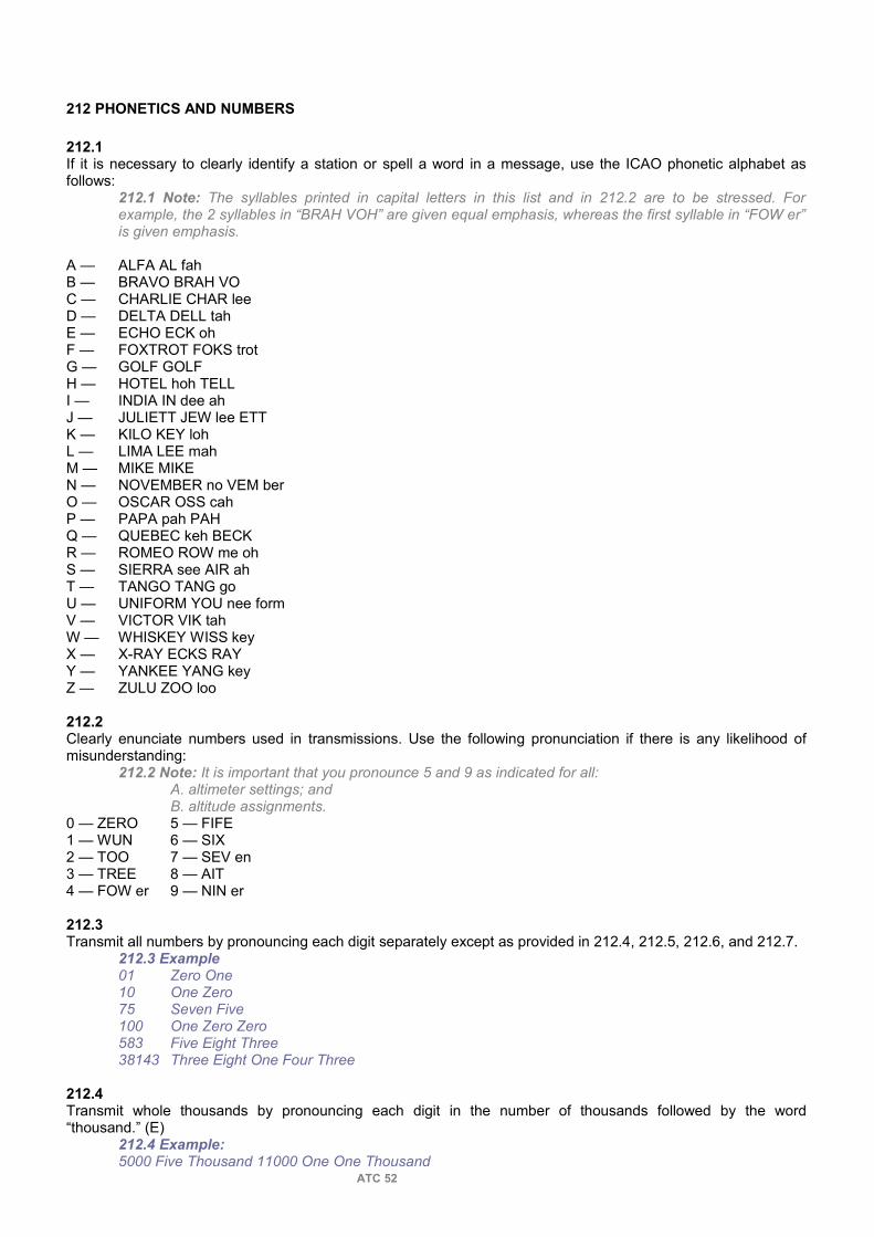
212 PHONETICS AND NUMBERS
212.1If it is necessary to clearly identify a station or spell a word in a message, use the ICAO phonetic alphabet as follows:
212.1 Note: The syllables printed in capital letters in this list and in 212.2 are to be stressed. For example, the 2 syllables in “BRAH VOH” are given equal emphasis, whereas the first syllable in “FOW er” is given emphasis.
A — ALFA AL fahB — BRAVO BRAH VOC — CHARLIE CHAR leeD — DELTA DELL tahE — ECHO ECK ohF — FOXTROT FOKS trotG — GOLF GOLFH — HOTEL hoh TELLI — INDIA IN dee ahJ — JULIETT JEW lee ETTK — KILO KEY lohL — LIMA LEE mahM — MIKE MIKEN — NOVEMBER no VEM berO — OSCAR OSS cahP — PAPA pah PAHQ — QUEBEC keh BECKR — ROMEO ROW me ohS — SIERRA see AIR ahT — TANGO TANG goU — UNIFORM YOU nee formV — VICTOR VIK tahW — WHISKEY WISS keyX — X-RAY ECKS RAYY — YANKEE YANG keyZ — ZULU ZOO loo
212.2Clearly enunciate numbers used in transmissions. Use the following pronunciation if there is any likelihood of misunderstanding:
212.2 Note: It is important that you pronounce 5 and 9 as indicated for all:A. altimeter settings; andB. altitude assignments.
0 — ZERO 5 — FIFE1 — WUN 6 — SIX2 — TOO 7 — SEV en3 — TREE 8 — AIT4 — FOW er 9 — NIN er
212.3Transmit all numbers by pronouncing each digit separately except as provided in 212.4, 212.5, 212.6, and 212.7.
212.3 Example01 Zero One10 One Zero75 Seven Five100 One Zero Zero583 Five Eight Three38143 Three Eight One Four Three
212.4Transmit whole thousands by pronouncing each digit in the number of thousands followed by the word “thousand.” (E)
212.4 Example:5000 Five Thousand 11000 One One Thousand
ATC 52

212.5You may express altitude above sea level in thousands plus hundreds of feet. Use separate digits to express flight levels.
212.5 Example:2700 Two Thousand Seven Hundred.13200 One Three Thousand Two Hundred.FL265 Flight Level Two Six Five.FL200 Flight Level Two Zero Zero.
212.6You may express aircraft identification flight numbers and aircraft type numbers in group form, provided there is no likelihood of misunderstanding. Consider FAA vs ICAO regulations.
212.6 Example:WJA620 WestJet Six Twenty / WestJet Six Two ZeroACA1240 Air Canada Twelve Forty / Air Canada One Two Four ZeroDC10 DC Ten / DC One ZeroA320 A Three Twenty / Airbus Three Two Zero
212.7You may express wind speed, RVR data and cloud height in group form.
212.7 Example:WIND TWO SEVEN ZERO AT TEN (ONE ZERO).WIND TWO THREE ZERO AT TWENTY (TWO ZERO GUSTING THIRTY/THREE ZERO).BKN 35 — THIRTY FIVE HUNDRED BROKEN (THREE THOUSAND FIVE HUNDRED).RVR2800 — RVR TWO THOUSAND EIGHT HUNDRED FEET.
212.8Except when issuing altimeter settings, transmit numbers containing a decimal point with the word “decimal” in the appropriate sequence. However, in assigning VHF or UHF frequencies, you may omit the decimal point provided the omission is not likely to cause any misunderstanding.
212.8 Example:118.1 One One Eight Decimal One.119.4 One One Niner Four.
212.9If transferring an aircraft to a frequency with 25 kHz spacing, do not include the sixth digit. If the aircraft cannot comply with a frequency assignment having a 2 or 7 as the fifth digit, assign a back-up frequency.
212.10Issue headings as 3-digit numbers expressed in degrees magnetic. Use “heading 360” to signify a north heading.
212.10 Note:The word degrees and magnetic are omitted with reference to magnetic heading and only the word true follows the number where references are to true headings.212.10 Example:005 degrees magnetic Heading Zero Zero Five030 degrees magnetic Heading Zero Three Zero360 degrees magnetic Heading Three Six Zero040 degrees true Heading Zero Four Zero True180 degrees true Heading One Eight Zero True
212.11Express speed by pronouncing each digit separately followed by “KNOTS” or by pronouncing each digit of the MACH number preceded by “MACH”. (E)
212.11 Example:90 knots Speed Nine Zero Knots250 knots Speed Two Five Zero KnotsMach 1.3 Mach One Decimal ThreeMach 0.82 Mach Decimal Eight Two
213 WORDS AND PHRASES
ATC 53

213.1Use the following words and phrases, if practicable, in radio and interphone communication:ACKNOWLEDGE: “Let me know that you have received and understood this message”AFFIRMATIVE: “Yes” or “Permission granted”.BREAK: “I hereby indicate the separation between portions of the message”. (N)
213.1 Note 1: This word is intended to be used where there is no clear distinction between the text and other portions of the message.
CORRECTION: “An error has been made in this transmission. The correct version is ...”.EXPEDITE: “Comply with this instruction as promptly as possible”.GO AHEAD: “Proceed with your message”.HOW DO YOU READ: Self-explanatory.I SAY AGAIN: Self-explanatory.NEGATIVE: “No”, or “Permission not granted”, or “That is not correct”.OUT: “This conversation is ended and no response is expected”.OVER: “My transmission is ended and I expect a response from you”. READ BACK: “Repeat all of this message back to me”.ROGER: “I have received all of your last transmission”.
213.1 Note 2: This word is used to acknowledge receipt and is not intended to be used for other purposes.
SAY AGAIN: Self-explanatory.SPEAK SLOWER: Self-explanatory.STAND-BY: Self-explanatory.THAT IS CORRECT: Self-explanatory.VERIFY: Check coding, check text with originator, and send correct version.WILCO: (abbreviation for “will comply”) I understand your message and will comply with it.WORDS TWICE: As a request: “Communication is difficult. Please say every word twice”. As information: “Since communication is difficult, every word in this message will be said twice”.
214 UNITS OF MEASUREMENT
214.1Give altimeter settings in inches of mercury or millibars, to the nearest hundredth of an inch or rounded upwards when using millibars.
214.2Issue wind direction as follows: A. Analog wind display — in degrees magnetic to the nearest 10 degrees and the windspeed to the nearest 5 knots; orB. Digital wind display — the readout value. (ivac 1.x)
214.3Unless otherwise specified, indicate time in terms of the 24-hour clock system and in UTC. Use the time group 0000Z to indicate midnight. Transmit time checks as follows:A. Analog clock — to the nearest 15 seconds.B. Digital clock — the readout value.
214.4Use knots or Mach-number to indicate speed, nautical miles to indicate distance. However, report visibility in statute miles or kilometers/meters.
215 UNIT IDENTIFICATION
215.1Identify ATC units and their function in airground communications as follows:
A. Airport Control Service:
Airport Control (name) TOWERGround Control (name) GROUNDClearance Delivery (name) CLEARANCE/DELIVERY
B. Terminal Control Service:
ATC 54

Terminal Control (name) TERMINAL/APPROACH/DIRECTOR/RADARArrival Control (name) ARRIVAL/DIRECTORDeparture Control (name) DEPARTURE
C. Area Control Service:
All Sectors (name) CONTROL(ICAO)/CENTRE(FAA)
D. Flight Service Station:
All Services (name) RADIO/INFORMATION215.1 Note: Look for local AIP to find the suitable ATC unit call sign.
215.2You may omit the name and the function of the unit from a radio transmission provided:A. the unit has been previously identified;
215.2 A. Note:In situations where a sector has multiple frequencies or when sectors are combined using multiple frequencies, it is not necessary to restate unit identification when an aircraft is changed to another frequency under your jurisdiction.215.2 A. Example:AIR CANADA TWO FOUR SEVEN CHANGE TO FREQUENCY 128.5.
B. only one function is being provided; andC. there is no likelihood of misunderstanding.
215.3State the function if you are performing more than one function on two or more frequencies.
216 AIRCRAFT IDENTIFICATION
216.1Identify Canadian and Foreign civil aircraft by using one of the following methods: A. Air Carriers with radiotelephony designators:
216.1 A. Example:SKYTOUR 620 HEAVY.JAPANAIR 22 HEAVY.SPEEDBIRD GOLF ALFA BRAVO CHARLIE DELTA.1. the operator's radiotelephony designator;2. the flight number or last four characters of the registration;3. the word “HEAVY” if applicable; and
B. Private Aircraft without radiotelephonydesignators:
216.1 B. Example:BEECH GOLF X-RAY BRAVO DELTA MEDEVAC.CITATION 739 X-RAY.ECHO CHARLIE ALPHA BRAVO CHARLIE1. the manufacturer's name or type of aircraft if applicable; (N)216.1 C. 1. Note: Helicopters, gliders and ultralights often prefix their call-sign with “Helicopter”, “Glider” or “Ultralight” this practice fulfills the same purpose as stating the manufacturer's name or type of aircraft and is an acceptable substitute.2. the last four characters of the aircraft registration if 1 applies. If not, the full register in phonetic alphabet; and3. the word “HEAVY” if applicable.
216.2You may abbreviate civil aircraft radiotelephony call-signs, once communication has been established, by omitting the word “heavy” and using one of the following methods:A. Air Carriers with radiotelephony designators:
1. no abbreviation. 216.2 A. 1. Example:AIR CANADA 834.2. may be abbreviated to the radiotelephony designator followed by the last two characters of the aircraft's registration, if the full aircraft registration is used following the operator's radiotelephony designator.
ATC 55

216.2 A. 2. Example:SPEEDBIRD CHARLIE DELTA.
B. Private Aircraft without radiotelephony designators:1. the radiotelephony call sign may be abbreviated to the last three characters of the aircraft's registration. (FAA)216.2 B. 1. Example:BRAVO ZULU ALFA.46 X-RAY.2. the radiotelephony call sign may be abbreviated to the first letter and the last two when using aircraft's registration as a call sign216.2 B.2 Example:ECABC ECHO BRAVO CHARLIE
216.3Use phonetics if the call sign consists of the aircraft's registration.
216.4INTENTIONALLY BLANK
216.5Identify military and Coast Guard aircraft by using their appropriate call sign according to local agreements.
216.6Apply the terms “HEAVY” to military and coast guard flights, in the same manner as with civil flights, according to local regulations.
216.7Do not abbreviate military and coast guard aircraft identifications.
216.8On initial contact, repeat the military call sign as given, by the aircraft. After initial contact, you may omit words describing aircraft type.
216.8 Note:Terms such as “jet”, “helicopter”, or “heavy” may be included in the call sign on initial contact.
216.9If two or more aircraft are using the same flight number or similar sounding identifications, you may:
216.9 Note: Coordination may be required when such an aircraft is transferred from your frequency or if both aircraft are transferred to the same frequency.
A. advise each of the aircraft concerned on your frequency of the other's presence;B. add the type of aircraft to the identification; orC. instruct the aircraft using the same flight number or similar sounding identification to use its aircraft registration.
216.10INTENTIONALLY BLANK
216.11
217 MESSAGE FORMAT
217.1You may omit words “this is”, “over”, and other similar terms from radio transmissions provided there is no likelihood of misunderstanding.
217.2Differentiate between an ATC clearance and an ATC instruction as follows:
A. Prefix an ATC clearance with “ATC CLEARS (aircraft identification)”. You may prefix a clearance with “(aircraft identification) CLEARED” provided DCPC is used.B. Indicate an instruction by using an action verb in the imperative mood. You may use the prefix “ATC INSTRUCTS (aircraft identification)” provided you consider it necessary for emphasis in unusual circumstances.
217.2 B. Note: Action verbs in the imperative mood include words such as stop, follow (aircraft type), climb, or maintain.
ATC 56

217.3Prefix messages, other than clearances and instructions, originating within an IFR unit for transmission to an aircraft as follows:A. ATC ADVISES (aircraft identification) — if issuing information, such as:
1. an expect-approach-clearance time;2. undetermined delay; or3. traffic.
B. ATC SUGGESTS (aircraft identification) — if issuing advice to aircraft operating outside controlled airspace or making a suggestion to any aircraft.C. ATC REQUESTS (aircraft identification) — if requesting information from an aircraft.
218 NAVAID IDENTIFICATION
218.1Identify radio NAVAIDs, in ATC communications, as follows:A. VORs, DMEs, TACANs and Multiple letter NDBs by stating:
218.1 A. Example:YARMOUTH VORTRENTON TACANSARNIA NDB1. the location name or, if the name is difficult to pronounce, the coded designator with mandatory use of phonetics; and 218.1 A. 1. Example:KANGIRSUK—YANKEE ALFA SIERRAMATAGAMI—NOVEMBER MIKETUKTOYAKTUK—YANKEE UNIFORM BRAVO2. the type of NAVAID;
B. single letter NDBs by stating: (N)(E) * 218.1 B. Note: Single letter NDBs are usually associated with approach aids and are not shown on HI and LO charts.
218.1 B. Example:OSCAR NDBSIERRA NDB1. the phonetic pronunciation of the identifying letter; and2. the type of NAVAID.
219 AIRWAY AND AIR ROUTE IDENTIFICATION
219.1Identify all the designated airways and air routes by pronouncing the letter(s) designator in accordance with the ICAO phonetic alphabet, except for:A. Jet airways.B. Victor Airways.C. Upper Airways.D. Lower Airways.E. Kopter Airways.
219.1 Example:G1 — GOLF ONEAR 2— ALFA ROMEO TWOJ500— JET FIVE ZERO ZEROUN870—UPPER NOVEMBER EIGHT SEVEN ZERO
ATC 57

220 AIR TRAFFIC SERVICES MESSAGES
221 GENERAL
221.1 IFR, CVFR, and SVFR movement and control messages include the following: 221.1 Note: The following is the normal sequence of communications required for an IFR flight:A. The pilot files a flight plan with a flight plan office.B. The flight plan office forwards the flight plan message to the appropriate ACC.C. The pilot obtains an ATC clearance before takeoff.D. After departure, a departure message is forwarded to the ACC.E. En route position report message and requests for further clearance are forwarded to the ACC.F. After arrival, an arrival message is forwarded to the ACC.
A. Air traffic clearances.B. Departure report messages.C. Position report messages.D. Control messages concerning flights requiring approval prior to departure.E. Arrival messages.F. Flight plan messages.
221.2DVFR and VFR movement messages include the following: A. DVFR flight plan and defence flight itinerary messages.B. DVFR position report messages (flight plan or flight itinerary).C. VFR flight plan and flight itinerary messages.D. VFR position report messages.E. Arrival report messages.
ATC 58

PART 3 — AIRPORT AND VFR CONTROL
300 _ GENERAL
301 PROVISION OF SERVICE302 RUNWAY SELECTION303 TAXI INFORMATION304 VHF DIRECTION FINDING SYSTEM305 AIRPORT EQUIPMENT306 TOWER CAB LIGHTING307 AIRPORT SURFACE DETECTION EQUIPMENT308 VISUAL SCANNING — MANOEUVRING AREA
310 _ SPECIAL OPERATIONS
311 SPECIAL VFR312 VFR TRAFFIC MANAGEMENT313 FORMATION FLIGHTS314 BELOW MINIMA OPERATIONS315 DENIAL OF CLEARANCE316 RONLY AND NORDO317 HANG GLIDERS AND ULTRA-LIGHT AEROPLANES
320 _ ESSENTIAL FLIGHT INFORMATION
321 GENERAL322 AIRPORT CONDITIONS323 ARRESTER GEAR
330 _ DEPARTURES
331 GENERAL332 PRE-TAXI333 IFR CLEARANCE334 TAXI AUTHORIZATION335 SUCCESSIVE IFR DEPARTURES — VISUAL SEPARATION336 TAKE-OFF PROCEDURES337 CANCELLATION OF TAKE-OFF CLEARANCE338 VFR DEPARTURE OF AN IFR AIRCRAFT
340 _ ARRIVALS
341 LANDING INFORMATION342 INITIAL CLEARANCE343 APPROACH CLEARANCE344 LANDING CLEARANCE345 TAXI AUTHORIZATION346 ILS/MLS OPERATION347 CATEGORY II/III ILS APPROACHES
350 _ AIRPORT TRAFFIC
351 APPLICATION352 ARRIVALS AND DEPARTURES353 HELICOPTERS354 PEDESTRIANS AND VEHICLES
360 _ COORDINATION
361 REPORTS362 CONTROL TRANSFER363 COMMUNICATION TRANSFER
ATC 59
370 _ AIRPORT LIGHTING
371 GENERAL
380 _ WAKE TURBULENCE
381 APPLICATION382 MINIMA383 WAKE TURBULENCE AVOIDANCE384 AIRCRAFT INITIATED WAIVER
390 _ RADAR SERVICE
391 APPLICATION392 SEPARATION393 MINIMA394 CONFLICT RESOLUTION
ATC 60

PART 3 — AIRPORT AND VFR CONTROL
300 GENERAL
301 PROVISION OF SERVICE
301.1The objective of airport and VFR control service is to maintain a safe, orderly, and expeditious flow of air traffic under the control of a Control Tower.
301.2Provide VFR control service to:A. airport traffic operating on the manoeuvring area;B. VFR aircraft operating within the control zone or Tower Radar Area; andC. IFR aircraft for which the tower has responsibility for control.
301.3Issue take-off or landing clearance to a fixedwing aircraft provided the operation takes place on:A. a runway; orB. another area that is approved and designated for that purpose.
301.4Provide information concerning known traffic and obstructions to fixed-wing aircraft landing on or taking off from a surface other than a runway or another area that is approved for thatpurpose.
301.4 Phraseology:LAND/TAKE OFF AT YOUR DISCRETION — and if necessary — TRAFFIC (description).301.4 Note: Except in an emergency situation, fixed-wing aircraft are not permitted to depart from or land on a taxiway.
302 RUNWAY SELECTION
302.1Assign the operationally suitable runway most nearly aligned into the wind if the wind speed is 5 knots or more.
302.2You may assign the “calm wind runway” provided:
302.2 Note: A “calm wind runway” is one that offers an operational advantage because of:A. length;B. better approach;C. shorter taxiing distance;D. noise abatement procedures;E. necessity to avoid flight over populated areas; orF. other reasons.
A. the wind speed is less than 5 knots; andB. you clearly indicate the wind direction and speed to the aircraft.
302.3You may suggest, or approve a request for, another runway provided:
A. you or the aircraft will gain an operational advantage; andB. you clearly indicate the wind direction and speed to the aircraft.
302.4At airports where runway configurations are appropriate, you may segregate light VFR aircraft from heavy VFR or IFR aircraft by using different runways, provided:
A. the surface wind components permit the use of more than one runway; andB. the pilot accepts the suggested runway.
ATC 61
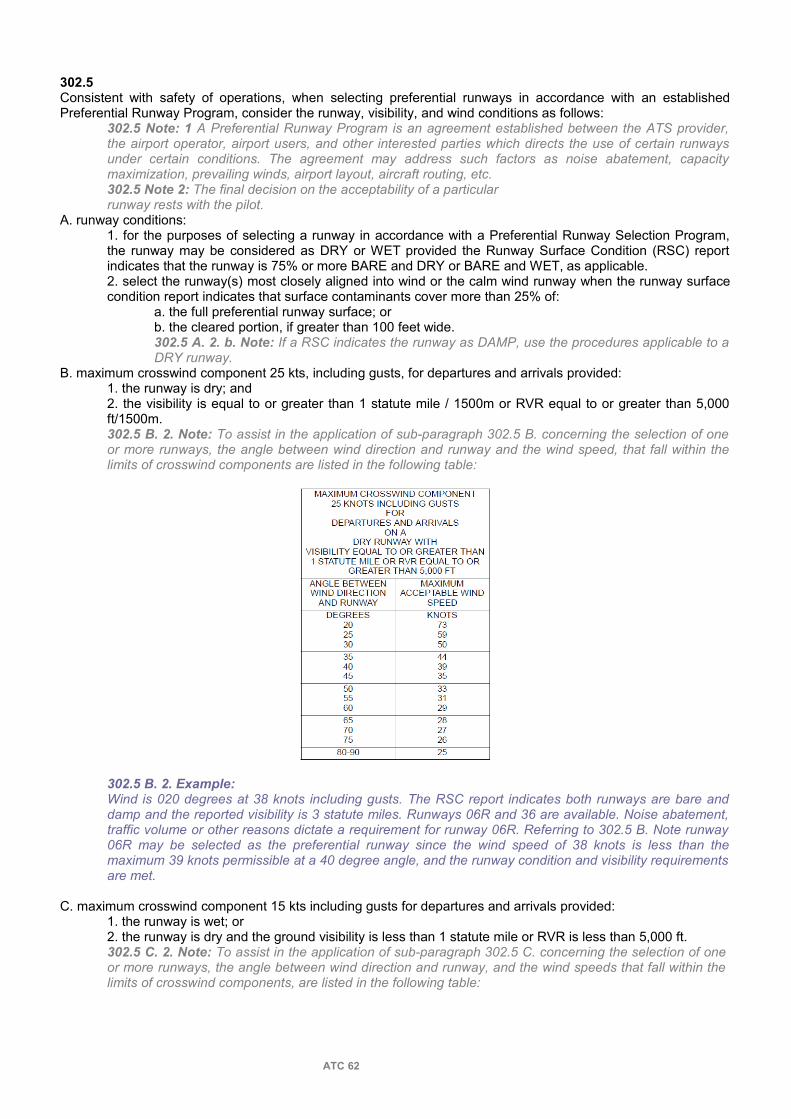
302.5Consistent with safety of operations, when selecting preferential runways in accordance with an established Preferential Runway Program, consider the runway, visibility, and wind conditions as follows:
302.5 Note: 1 A Preferential Runway Program is an agreement established between the ATS provider, the airport operator, airport users, and other interested parties which directs the use of certain runways under certain conditions. The agreement may address such factors as noise abatement, capacity maximization, prevailing winds, airport layout, aircraft routing, etc.302.5 Note 2: The final decision on the acceptability of a particularrunway rests with the pilot.
A. runway conditions:1. for the purposes of selecting a runway in accordance with a Preferential Runway Selection Program, the runway may be considered as DRY or WET provided the Runway Surface Condition (RSC) report indicates that the runway is 75% or more BARE and DRY or BARE and WET, as applicable. 2. select the runway(s) most closely aligned into wind or the calm wind runway when the runway surface condition report indicates that surface contaminants cover more than 25% of:
a. the full preferential runway surface; orb. the cleared portion, if greater than 100 feet wide. 302.5 A. 2. b. Note: If a RSC indicates the runway as DAMP, use the procedures applicable to a DRY runway.
B. maximum crosswind component 25 kts, including gusts, for departures and arrivals provided:1. the runway is dry; and2. the visibility is equal to or greater than 1 statute mile / 1500m or RVR equal to or greater than 5,000 ft/1500m. 302.5 B. 2. Note: To assist in the application of sub-paragraph 302.5 B. concerning the selection of one or more runways, the angle between wind direction and runway and the wind speed, that fall within the limits of crosswind components are listed in the following table:
302.5 B. 2. Example:Wind is 020 degrees at 38 knots including gusts. The RSC report indicates both runways are bare and damp and the reported visibility is 3 statute miles. Runways 06R and 36 are available. Noise abatement, traffic volume or other reasons dictate a requirement for runway 06R. Referring to 302.5 B. Note runway 06R may be selected as the preferential runway since the wind speed of 38 knots is less than the maximum 39 knots permissible at a 40 degree angle, and the runway condition and visibility requirements are met.
C. maximum crosswind component 15 kts including gusts for departures and arrivals provided:1. the runway is wet; or2. the runway is dry and the ground visibility is less than 1 statute mile or RVR is less than 5,000 ft. 302.5 C. 2. Note: To assist in the application of sub-paragraph 302.5 C. concerning the selection of one or more runways, the angle between wind direction and runway, and the wind speeds that fall within the limits of crosswind components, are listed in the following table:
ATC 62
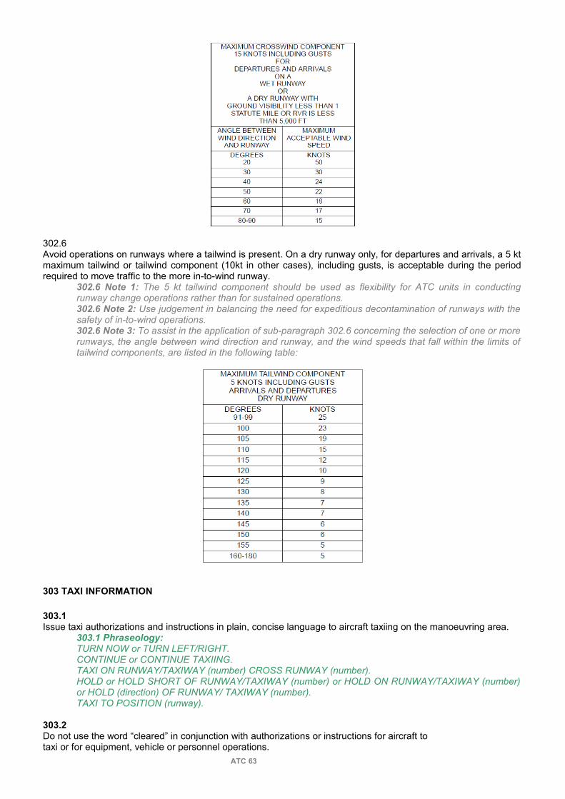
302.6Avoid operations on runways where a tailwind is present. On a dry runway only, for departures and arrivals, a 5 kt maximum tailwind or tailwind component (10kt in other cases), including gusts, is acceptable during the period required to move traffic to the more in-to-wind runway.
302.6 Note 1: The 5 kt tailwind component should be used as flexibility for ATC units in conducting runway change operations rather than for sustained operations.302.6 Note 2: Use judgement in balancing the need for expeditious decontamination of runways with the safety of in-to-wind operations.302.6 Note 3: To assist in the application of sub-paragraph 302.6 concerning the selection of one or more runways, the angle between wind direction and runway, and the wind speeds that fall within the limits of tailwind components, are listed in the following table:
303 TAXI INFORMATION
303.1Issue taxi authorizations and instructions in plain, concise language to aircraft taxiing on the manoeuvring area.
303.1 Phraseology:TURN NOW or TURN LEFT/RIGHT.CONTINUE or CONTINUE TAXIING.TAXI ON RUNWAY/TAXIWAY (number) CROSS RUNWAY (number).HOLD or HOLD SHORT OF RUNWAY/TAXIWAY (number) or HOLD ON RUNWAY/TAXIWAY (number) or HOLD (direction) OF RUNWAY/ TAXIWAY (number). TAXI TO POSITION (runway).
303.2Do not use the word “cleared” in conjunction with authorizations or instructions for aircraft totaxi or for equipment, vehicle or personnel operations.
ATC 63

303.3Do not use conditional clearances or instructions for the movement of airport traffic.
303.3 Note:Misinterpretation could be caused by a conditional clearance or instruction such as:A. taxi to position behind the landing aircraft; orB. proceed across runway one two after departing DC9.
303.4Include the specific route if alternate taxi paths are available.
303.5Instruct an aircraft or vehicle to either “cross” or “hold short” of any runway it will cross while on the manoeuvring area.
303.6If workload permits, provide information concerning known traffic and obstructions to aircraft taxiing outside of the manoeuvring area.
303.6 Phraseology:TAXI AT YOUR DISCRETION — and if necessary — TRAFFIC (description).303.6 Note:Movement of aircraft on the Apron is the responsibility of the pilot, the aircraft operator or the Airport Operator.
303.7If you consider it necessary, inform a taxiing aircraft that a portion of the manoeuvring area is not visible from the tower.
303.7 Phraseology:(Area) NOT VISIBLE, TAXI AT YOUR DISCRETION.303.7 Note: This is intended to cover situations where your view of the manoeuvring area is obstructed by a physical condition other than weather phenomena.
304 VHF DIRECTION FINDING SYSTEM (VDF)
304.1Do not use DF bearing information to separate aircraft.
304.2You may use DF bearing information to assist in visually locating an aircraft by correlating the DF bearing with the reported position of the aircraft.
304.3Request an aircraft to confirm its position if, in your judgment, the DF bearing and the reported position do not reasonably agree.
304.3 Phraseology:CONFIRM YOUR POSITION.304.3 Note 1:An inaccurate DF bearing indication may result when two or more aircraft transmit simultaneously.304.3 Note 2:Because of equipment tolerances and site location of the VDF antenna, allowances have to be made in determining the reliability of the position report.
304.4If an aircraft's position remains doubtful following a request for confirmation, inform the aircraft and use whatever other means are available to establish its position. (P)(N)
304.4 Phraseology:DF INFORMATION INDICATES YOUR BEARING TO BE (actual bearing).304.4 Note: Other means may include visual sighting, radar unit assistance, adjacent VDF assistance, and aircraft's heading.
305 AIRPORT EQUIPMENT
305.1 Keep fully informed of the operating status of airport equipment used by aircraft or ATC. (R)
ATC 64

305.2Display the operating status, if other than normal, so that it will immediately attract the attention of all concerned personnel.
305.3INTENTIONALLY BLANK
306 TOWER CAB LIGHTING
306.1Keep lighting in the Control Tower cab to a minimum at all times. (N)
306.1 Note:Due to operational requirements of equipment (keyboards, strips), lighting levels must be adjusted to enable operation of the equipment and at the same time not interfere with visual acuity of the airport surroundings at night.
307 AIRPORT SURFACE DETECTION EQUIPMENT
307.1Augment visual observation of traffic operating on the manoeuvring area by referring to ASDE (Ivac ground radar):
307.1 Note:Visual scanning is considered the primary technique.
A. at night;B. when visibility, for any reason, is less than the most distant point of the manoeuvring area; orC. at any other time when, in your opinion, an operational advantage will be gained.
307.2You may use ASDE derived information to:
307.2 Note 1: Availability of ASDE information does not relieve the controller of the requirement to carry out all necessary coordination with other operating positions.307.2 Note 2: A verbal report from an identified aircraft or vehicle is not necessary if the ASDE indicates it has exited the area in question as instructed.307.2 Note 3: The ASDE-3 is designed to detect a target with a radar cross section of 3 square meters. This would include a vehicle as small as the smallest passenger car or truck.
A. determine that a runway or taxiway is clear of aircraft, vehicles or obstructions prior to a landing or a takeoff; B. confirm the location of aircraft and vehicles on the displayed airport manoeuvring area;C. provide directional instruction to pilots and vehicle operators on the displayed manoeuvring area when requested by them, or when deemed necessary by the controller;
307.2 C. Phraseology:TURN LEFT/RIGHT AT THE NEXT TAXIWAY/ RUNWAY.TURN LEFT/RIGHT ON TAXIWAY/RUNWAY (number) APPROXIMATELY (number) FEET AHEAD.307.2 C. Note:In order to be effective for this purpose the display must be closely and continuously monitored.
D. confirm compliance with control instructions to aircraft or vehicles operating on the displayed manoeuvring area; andE. provide directional instruction to crash, fire and rescue vehicles manoeuvring on any displayed area, as necessary.
307.3You may use ASDE provided you are satisfied that the presentation and performance are adequate for the function being performed.
307.4Identify a target observed on the ASDE display by correlating its position with one or more of the following:A. Pilot or vehicle operator position report.B. Controller's visual observation.C. An identified target return observed from another radar source.
ATC 65

307.5Do not provide directional guidance in the form of headings if using ASDE.
308 VISUAL SCANNING — MANOEUVRING AREA
308.1Airport and Ground controllers shall visually scan the manoeuvring area thoroughly before issuing clearances or instructions to airport traffic, and, to the extent possible, at other frequent intervals.
308.1 Note 1: At those locations where radar is available and there is no dedicated radar position, the airport controller's primary responsibility is to visually scan for airport traffic.308.1 Note 2: The following list of scanning techniques is included to assist in developing methods for scanning the manoeuvring area:
A. scanning has to be systematic;B. people can get “object hypnosis”, and only see things which move (scanning at least twice will help overcome this);C. the eyes should move from one point to another (not one continuous sweep);D. scanning should be from left to right, the same as you read; andE. the eye can only focus on an area that would be covered by the fist when your arm is extended in front of you.
308.2Ensure that the runway to be used by a departing or arriving aircraft is free, or will be free, of all known obstacles including vehicles, equipment and personnel before the departing aircraft commences its take-off roll or a landing aircraft crosses the runway threshold.
308.2 Note 1: In the case of an aircraft departing from an intersection, there is no need to advise of obstructions on the runway which are behind the intersection take-off point.308.2 Note 2: If the runway or a portion of the runway is not visible to the airport controller for any reason, including weather or a physical obstacle, it is expected you will ensure that vehicles, equipment and personnel you have been made aware of, are not on the runway.
ATC 66

310 SPECIAL OPERATIONS
311 SPECIAL VFR
311.1Authorize SVFR within the control zone provided:
311.1 Phraseology:SPECIAL VFR IS APPROVED IN THE (name) CONTROL ZONE, (cut-off time if required), (additional control instructions as necessary).
A. the aircraft has requested SVFR;B. you determine that the weather is at or above the minima for SVFR; (N)(R)
311.1 B. Note: The visibility minima for SVFR is 1 mile/1500m for fixed wing aircraft and ½ mile for rotorcraft and must represent the highest value common to sectors comprising one-half or more of the horizon circle.
C. you obtain approval from the appropriate IFR Unit; (N)311.1 C. Note: This approval may be contained in an arrangement.
D. you make an adequate arrangement for recall;E. you keep SVFR aircraft clear of the flight paths of IFR aircraft; andF. you authorize only the number of aircraft that you can control safely and efficiently.
311.1 F. Note: The number of aircraft you authorize during SVFR conditions may vary, depending on factors such as the time required for recall if approval for SVFR is withdrawn by the IFR unit, and the stability of weather conditions.
311.2With the exception of helicopters, do not authorize SVFR aircraft to depart or transit the zone at night.
311.3You may authorize more than one SVFR aircraft in a circuit provided the aircraft will remain in sight of the tower at all times.
311.4At airports where specific local procedures have been approved for special VFR helicopter operations, you may authorize flights in accordance with the Agreement.
312 VFR TRAFFIC MANAGEMENT
312.1If traffic density warrants, you may instruct aircraft to hold on the ground or in the air in order to keep the number of VFR aircraft at a level that you can control safely and efficiently.
312.2Do not restrict or suspend VFR operations in the control zone or in the Tower Radar Area.
313 FORMATION FLIGHTS
313.1You may authorize a VFR formation flight within the control zone provided airport traffic permits.
313.2Treat a formation flight as one aircraft for the purpose of separation. Issue clearances and instructions to the formation leader.
314 BELOW MINIMA OPERATIONS
314.1If a VFR or SVFR aircraft requests a clearance, when weather conditions are below the applicable minima, take the following actions:
A. inform the aircraft that weather conditions are below minima, state the reported ceiling and visibility; (P)ATC 67

314.1 A. Phraseology:WEATHER BELOW VFR/SVFR MINIMA. CEILING (description), VISIBILITY (number) MILES/METERS.
B. inform the aircraft that only IFR or SVFR operations will be approved and request the pilot's intentions; 314.1 B. Phraseology:ONLY IFR OR SVFR OPERATIONS ARE PERMITTED. WHAT ARE YOUR INTENTIONS?
C. issue clearance if:1. traffic and airport conditions permit; and2. the aircraft still wishes to land, take off or operate within the airspace; and
D. complete an aviation occurrence report if the operation takes place below SVFR conditions and inform the pilot, at an appropriate time, that an occurrence report will be filed.
314.2If an IFR aircraft requests a take-off clearance, and the ground visibility is less than the applicable minimum, take the following actions:
314.2 Note: Some runways or aerodromes do not have published take-off minima. This does not preclude IFR takeoffs from these runways or aerodromes. However, it is the pilot's responsibility to avoid obstacles on departure and make adjustments to the take-off visibility requirements. Controllers who are queried regarding the take-off limits should state that it is the pilot's responsibility to determine the requirements if they are not published and that the minimum visibility should not be less than one-half mile (one-quarter mile for rotorcraft).
A. issue the RVR and the ground visibility; and314.2 A. Note: Ground visibility may be the prevailing visibility as included in the current weather sequence or as observed by an airport controller.
B. issue clearance if traffic and airport conditions permit;
314.3When an IFR aircraft is inbound to the outer marker or final approach fix and the RVR indicates less than 1,200 feet for the runway to be used, take the following actions:A. issue the current RVR and ground visibility;B. request the pilot's intention;C. issue clearance if traffic and airport conditions permit; andD. complete the aviation occurrence reportafter the aircraft has landed and inform the pilot that an occurrence report will be filed.
314.3 D. Note: If the ground visibility issued in accordance with 314.3 A. is at least 1/4 mile, an occurrence report is not required.
315 DENIAL OF CLEARANCE
315.1You may base denial of a clearance upon instructions from an appropriate authority regarding conditions not involving air traffic.
315.2INTENTIONALLY BLANK:
315.3Do not authorize airport traffic to use an airport or any part of an airport that is closed by the Airport Operator. (N)
315.3 Note: The Airport Operator is responsible for closing an airport or any part of an airport’s infrastructure or manoeuvring area.
315.4If you refuse a request for a clearance for reasons other than traffic, take the following actions:A. advise the aircraft of the reason for the denial of clearance.B. If the aircraft persists in its intention to land or take off:
1. quote any pertinent NOTAM or directive regarding airport conditions; 315.4 B. 1. Example:NOTAM SPRINGBANK STATES RUNWAY ZERO SEVEN IS CLOSED FOR MAINTENANCE UNTIL (Date, Time).
2. when traffic permits, inform the aircraft that landing/take-off clearance cannot be issued and that the landing/takeoff will be solely the pilot's responsibility; and
315.4 B. 2. Phraseology:SINCE LANDING/TAKE-OFF CLEARANCE CANNOT BE ISSUED, YOU ARE LANDING/ TAKING OFF ON YOUR OWN RESPONSIBILITY — and wind, if required.
ATC 68

315.5Except as permitted in 315.6, do not clear an aircraft to land or take off if there is an obstruction, person, or vehicle:
315.5 Note: Exceptions are permitted in accordance with directions contained in 352.2 and 352.3.
A. on the landing area; orB. adjacent to the landing area so as to endanger the safety of the aircraft.
315.6Not applicable
316 RONLY AND NORDO
316.1You may request a RONLY aircraft to acknowledge a transmission in one of the following ways:A. to aircraft on the ground:
1. by moving the ailerons; or 316.1 A. 1. Phraseology:ACKNOWLEDGE BY MOVING AILERONS.
2. by moving the rudder; 316.1 A. 2. Phraseology:ACKNOWLEDGE BY MOVING RUDDER.
B. to aircraft in the air, by rocking the wings; or316.1 B. Phraseology:ACKNOWLEDGE BY ROCKING WINGS.
C. at night, to aircraft on the ground or in the air, by a single flash of landing lights.316.1 C. Phraseology:ACKNOWLEDGE BY A SINGLE FLASH OF LANDING LIGHTS.
316.2Do not request an aircraft to acknowledge a transmission by turning the navigation lights on and off.
316.3Use air traffic control light signals from the following table to control aircraft and the movement of vehicles, equipment and personnel on the manoeuvring area when radio communications cannot be employed.
316.3 Note 1: The note to 316.1 C. applies here also.316.3 Note 2: An arriving NORDO aircraft will join the traffic circuit on the downwind leg and a departing aircraft will taxi to the edge of the manoeuvring area without a clearance. However, a clearance must be obtained either by prearrangement or by visual signal before:
A. proceeding any closer than 200 feet from the runway in use;B. crossing or entering any runway;C. landing or taking off;D. taxiing back along the runway in use; andE. taxiing after being stopped by a red light.
ATC 69

316.4Do not project a light gun signal through mylar shades.
316.4 Note: The color and intensity of the light signal may be affected by the mylar shade.
317 HANG GLIDERS AND ULTRA-LIGHT AEROPLANES
317.1Unless prohibited in a unit directive, you may authorize hang glider or ultra-light aeroplane operations in the control zone.
317.2For the purpose of wake turbulence separation and cautionaries:
A. Consider all ultra-light aircraft as “light” category aircraft for the purpose of wake turbulence separation.B. Inform ultra-light aircraft of the type of aircraft they will be following on departure or in the vicinity of the airport.C. Consider all motorized aircraft as “heavy” aircraft in relation to hang gliders.
317.3You may clear a hang glider or an ultra-light aeroplane to land on or take off from an area of the airport other than a runway provided the area:A. is designated as an ultra-light landing and take-off area;B. is part of the controlled manoeuvring area; andC. is described in an agreement between the tower and the Airport Operator.
ATC 70

320 ESSENTIAL FLIGHT INFORMATION
321 GENERAL
321.1Issue information on field conditions and the status of airport equipment or services, either directly or through the IFR unit, in sufficient time for it to be useful to the aircraft.
321.1 Note: ATIS may be used.
321.2 Promptly provide aircraft with safety alerts when required. 321.2 Note: The information is to be issued immediately once the controller recognizes an unsafe situation. Once the aircraft is informed, it is solely the pilot's responsibility to determine what course of action, if any, will be taken.
322 AIRPORT CONDITIONS
322.1Inform concerned aircraft of the following conditions of which you have been made aware:A. Construction or maintenance work on or near the manoeuvring area.
322.1 A. Example:CONSTRUCTION WORK EAST SIDE RUNWAY THREE SIX. MAINTENANCE EQUIPMENT NORTH SIDE RUNWAY TWO SEVEN.
B. Rough parts of the manoeuvring area.C. Flooded or slippery parts of the manoeuvring area and braking action reports.
322.1 C. Example:RUNWAY TWO SIX, 100 PERCENT ICE COVERED AND SANDED, (braking action report).
D. Obstructions, including snowdrifts or piles of snow, on or near the manoeuvring area.E. Failure or irregular operation of any part of the airport lighting system. (E)
322.1 E. Example:THRESHOLD LIGHTS RUNWAY TWO NINER OUT OF SERVICE.
F. Other pertinent conditions.
322.2Indicate the type of aircraft and the time of the report if relaying a braking action report obtained from another aircraft.
322.2 Example:DC9 REPORTED BRAKING ACTION FAIR RUNWAY (number) AT 0825Z.
322.3INTENTIONALLY BLANK
323 ARRESTER GEAR
323.1Inform all aircraft, landing or taking off, of the position and status of arrester gear that is in place across either end of the runway being used.
323.1 Phraseology:APPROACH/DEPARTURE END CABLE IS UP/ DOWN. CLEARED TO LAND RUNWAY (number).323.1 Note: Aircraft arrester gear may be used for either approach-end or departure-end engagements depending upon the type of fighter aircraft. For example, CF18 operators often prefer an approachend system for landing and a departure-end system for takeoff.
323.2Issue a cautionary to all aircraft taxiing over an arrester cable.
323.2 Phraseology:CAUTION APPROACH END CABLE IS UP.
323.3If requested, inform an aircraft of:A. the distance of an in-place cable from the threshold; orB. the distance between in-place cables, if applicable..
ATC 71

330 DEPARTURES
331 GENERAL
331.1Reply to requests for radio checks and issue taxi instructions as necessary.
331.2Obtain and relay IFR clearances to departing aircraft by voice or by electronic platforms intended for this use.
332 PRE-TAXI
332.1 Reply to a request for a radio check in the following form:
332.1 Note: The readability scale using figures 1 to 5 has the following meaning:
A. (Aircraft identification).B. (Unit identification if required). C. READ YOU (Readability number).D. (Time and altimeter if appropriate).
332.2You should limit or suspend routine radio maintenance checks during periods of heavy traffic.
333 IFR CLEARANCE
333.1You should obtain and relay the IFR clearance before the aircraft begins to taxi if practicable.
333.1 Note: Any change to an aircraft’s original flight plan will have to be transmitted to the pilot in order to deliver a new clearance by voice.
333.2Relay an IFR clearance by voice in the following form:A. (Aircraft identification).B. (Unit identification, if required).
333.2 B. Note: The recommended practice is to deliver the initial IFR clearance before the aircraft enters the departure runway thus avoiding delays while in position.
C. IFR CLEARANCE (wait for the aircraft to indicate that it is ready to copy).D. ATC CLEARS (clearance verbatim, as received from the IFR unit).
333.3Check the details of the voice readback to ensure that the aircraft has received the correct clearance and issue the time if a CC, EAC, EFC or other time was issued as part of the clearance.
333.3 Phraseology:READBACK CORRECT, TIME (if required) (four figure group)333.3 Note 1: The aircraft must read back the clearance and any corrections except that traffic information may be acknowledged by the phrase “traffic received”.333.3 Note 2: Issuing the time to an aircraft will ensure the timely execution of CC, EAC and EFC restrictions.
333.4NOT APPLICABLE
ATC 72

334 TAXI AUTHORIZATION
334.1In countries where "push-back" clearance is not needed, do not authorize an aircraft to “push-back” or “power-back” from a loading position on the apron. Inform a pilot who requests approval for “push-back” or “power-back” that such action is at the pilot's discretion and inform the pilot of pertinent traffic.
334.1 Phraseology:PUSH-BACK/POWER-BACK AT YOUR DISCRETION — and if possible — TRAFFIC (description).334.1 Note: Pilots may use the term “power-back” to indicate that the power from the aircraft's engines is used to move the aircraft back from a loading position.
334.2Instruct an aircraft to either “cross” or “hold short” of any runway it will cross while taxiing.
334.3Issue a taxi authorization in the following form:A. (Aircraft identification).B. (Unit identification if required). C. RUNWAY (number).D. WIND (direction and speed). E. ALTIMETER (setting).F. TAXI VIA (route) or CONTINUE TAXI, VIA (route), (if applicable), CROSS RUNWAY (number) or HOLD SHORT OF (runway number or taxiway) or HOLD (position or direction relative to a position, runway, taxiway, other).
334.3 F. Phraseology:To a departure runway — TAXI VIA BRAVO.To a departure runway via multiple taxiways — TAXI VIA BRAVO AND DELTA.To cross a runway while taxiing towards the departure runway — TAXI VIA BRAVO, CROSS RUNWAY 28.To cross more than one runway or taxiway while taxiing towards the departure runway — TAXI VIA BRAVO, DELTA, CROSS RUNWAY 28 AND RUNWAY 33.To an intermediate point — TAXI VIA ECHO AND FOXTROT, HOLD SHORT OF GOLF RUNWAY 28.To resume taxiing — CONTINUE TAXI ACROSS RUNWAY 28 AND GOLF.334.3 F. Note: Initial movement instructions given to an aircraft or vehicle should only include that portion of the intended route to the first “hold” area or intermediate point.
G. (Other information such as traffic, airport conditions or RVR). 334.3 G. Note: Aircraft taxiing behind jet aircraft in freezing conditions may experience aggravated engine and airframe icing. Be alert to pilot advisories that increased taxi intervals may be required during freezing conditions.H. CONTACT TOWER (frequency) NOW/AT (location/time)/HOLDING SHORT or MONITOR TOWER (frequency) NOW/AT (location/time). (N)
334.3 H. Note: The optional use of the term “holding short” may be considered as a location for the purposes of communication transfer. The use of the term is not considered a restriction and does not require a readback.
334.4You may authorize a departure from an intersection provided:A. the aircraft requests it; orB. you suggest it and the aircraft accepts it.
334.5Inform the aircraft of the usable length of runway remaining before suggesting a departure from an intersection.
334.5 Phraseology:RUNWAY LENGTH REMAINING FROM INTERSECTION OF (taxiway) (number) FEET; ARE YOU ABLE TO DEPART FROM THE INTERSECTION?
334.6Precede a refusal or delay to a request, with the word “NEGATIVE” followed by further instructions and if necessary, the reason. (P)
334.6 Phraseology:NEGATIVE HOLD YOUR POSITION (reason);— or —NEGATIVE HOLD SHORT OF RUNWAY (number) (reason).
334.7
ATC 73

You need not include the altimeter in a taxi authorization if the information was issued in a pre-flight radio check or confirmed via ATIS information.
334.8You need not include the runway and wind in a taxi authorization if the information is included in the current ATIS broadcast and the aircraft acknowledges receipt of that broadcast.
335 SUCCESSIVE IFR DEPARTURES — VISUAL SEPARATION
335.1You may release a successive departing IFR aircraft from the same runway provided the following conditions are met: (R)
A. your visual observation confirms that the preceding IFR aircraft has departed and has turned to clear the departure path of the succeeding aircraft, or has reached a point on its departure path where it will no longer conflict with the departure path of the succeeding aircraft;
335.1 A. Note 1: Required ceiling and visibility will vary with each runway configuration and types of aircraft. In each instance, they must be sufficient for the airport controller to see that the leading aircraft is clear of the intended departure track of the following aircraft. Either or both aircraft may turn.335.1 A. Note 2: Consider aircraft type, probable rotation point and the turn radius of the following aircraft when deciding the point at which the leading aircraft is clear of the assigned track of the following aircraft.335.1 A. Diagram 1:
335.1 A. Diagram 2:
B. initial departure tracks diverge by 30 degrees or more; 335.1 B. Phraseology:FLY HEADING (number) — and if an altitude restriction is required — MAINTAIN (altitude).
C. applicable wake turbulence minima are complied with, unless waived by the succeeding aircraft; (D. traffic information is passed to the succeeding aircraft; and (P)(E)
335.1 D. Phraseology:TRAFFIC (aircraft type) TURNING (left/right). CLEARED FOR TAKEOFF RUNWAY (number).335.1 D. Example:
ATC 74

GOLF CHARLIE ROMEO FOXTROT, TRAFFIC IS A DASH 8 IN A LEFT TURN, CLEARED FOR TAKEOFF RUNWAY 27.
E. the procedure to be followed shall be in accordance with local regulations.
335.2You may use visual separation to release successive departing IFR aircraft from a runway different from that used by a preceding IFR departing aircraft provided the following conditions are met:
335.2 Note 1: This procedure may be applied between aircraft departing from:A. intersecting runways;B. non-intersecting runways;C. parallel runways, where one aircraft will turn towards the adjacent parallel runway.It is not applicable between aircraft departing from parallel runways and are required to maintain runway heading (normally due to noise abatement), or follow tracks that diverge by less than 15 degrees immediately after take off.335.2 Note 2: Aircraft departing from parallel runways and following tracks that diverge by at least 15 degrees immediately after take-off may be separated in accordance with ATC MANOPS 553.1.
A. if either aircraft will turn toward, or will cross through the departure path of the other, initial tracks diverge by 30 degrees or more;B. your visual observation confirms that the preceding aircraft has reached a point where it will no longer conflict with the departure path of the succeeding aircraft;
335.2 B. Note:335.1 A. Note applies here.
C. if required:1. applicable wake turbulence minima are complied with, unless waived by the succeeding aircraft; 2. traffic information is passed to the succeeding aircraft; and
335.2 C. 2. Phraseology:TRAFFIC (details as required) (if required CAUTION, POSSIBLE WAKE TURBULENCE), CLEARED FOR TAKE OFF RUNWAY (number).
D. the procedure is conducted in accordance with local regulations.
336 TAKE-OFF PROCEDURES
336.1Inform an aircraft of the reason for the delay if it is taxied to position and instructed to “WAIT”.
336.1 Phraseology:TAXI TO POSITION AND WAIT/LINE UP AND WAIT, TWO MINUTE IFR DELAY.BACKTRACK RUNWAY (number) TO POSITION AND WAIT, TRAFFIC LANDING RUNWAY (number).336.1 Note: Delays may be caused by preceding landing/ departing traffic, IFR delays or CRDA positioning.
336.2Specify the name of the taxiway or intersection with the instruction to taxi or backtrack to position.
336.2 Phraseology:TAXI TO POSITION (FAA) (if departure is from the threshold) or LINE UP AND WAIT (ICAO).TAXI TO POSITION AT DELTA (if departure is from a taxiway).TAXI TO POSITION AT RUNWAY 24 INTERSECTION (if departure is from a runway intersection).BACKTRACK RUNWAY (number) TO POSITION ATDELTA. (If the aircraft must backtrack the departure runway for a departure from an intersection or taxiway).REPORT WHEN READY
336.3Unless takeoff clearance can be issued within three minutes of the time the aircraft arrives at the point from which the takeoff run will begin, do not instruct a departing aircraft to line up the active runway(N)
336.3 Note 1: It is expected that an IFR release will be obtained within three minutes of the time the departing IFR aircraft reaches the point from which the takeoff run will begin.336.3 Note 2: Operational characteristics of some aircraft may require an extended period of time on the runway. The requirement to issue a clearance within three minutes may be waived in these situations.A. at night;B. during IFR meteorological conditions; orC. if it will not be visible from the tower.
ATC 75

336.4Except as specified in 336.16, inform an aircraft that is holding short of the runway of the reason for a delay if:
A. it appears that a take-off clearance may be delayed for more than 3 minutes; andB. the reason is not apparent. 336.4 B. Note: For example, you would not be expected to inform an aircraft if the reason for delay is another aircraft ahead waiting for takeoff or an aircraft on final approach.
336.5You may taxi more than one aircraft to position for takeoff on the same runway, intersecting runways or non intersecting runways whose flight paths cross, provided: (N)
336.5 Note: “Position" may be any point on the runway requested or accepted by the pilot and approved by the controller.
A. the aircraft are sequenced in accordance with 336.6; 336.5 A. Note: Caution should be exercised to prevent confusion among the involved aircraft.
B. all aircraft are visible to the airport controller; 336.5 B. Note: If visibility does not permit visual observation of the aircraft, ASDE may be used to confirm an aircraft's position.
C. traffic information is given to the second and subsequent aircraft in the departure sequence; andD. you specify the name of the runway intersection or taxiway if “position” is not at the threshold.
336.6If a departing aircraft is not number one, issue a departure sequence number in the following form:
336.6 Phraseology:For intersecting runways/flight paths - NUMBER TWO FOR DEPARTURE, TRAFFIC SEVEN TWENTY SEVEN DEPARTING RUNWAY (number).For same runway - NUMBER TWO FOR DEPARTURE, TRAFFIC KINGAIR IN POSITION (distance) FEET AHEAD.- or -NUMBER TWO FOR DEPARTURE, TRAFFIC KINGAIR IN POSITION AT (name of intersection).
A. Aircraft Identification.B. Number (sequence).C. Type and position of preceding departure.
336.7If requesting an IFR release specify the runway from which the aircraft will depart. (P)
336.7 Phraseology:REQUEST RELEASE (aircraft ident) RUNWAY (number).
336.8Include the name of the intersecting runway or taxiway from which an aircraft will depart in the take-off clearance.
336.9Issue alternate instructions with a clearance for an immediate takeoff unless you have previously determined that the aircraft can comply.
336.9 Phraseology:CLEARED FOR IMMEDIATE TAKEOFF RUNWAY (number) IF UNABLE, HOLD SHORT OF RUNWAY. TAXI TO POSITION (AT LOCATION IF NOT THE THRESHOLD), BE READY FOR IMMEDIATE DEPARTURE. ARE YOU ABLE AN IMMEDIATE DEPARTURE?— then — CLEARED FOR IMMEDIATE TAKEOFF RUNWAY (number).336.9 Note:
Aircraft unable to comply with an immediate takeoff clearance are expected to hold their position and advise the tower accordingly.
336.10Consider known aircraft operating characteristics and the effect that precipitation and surface conditions may have on the aircraft's ability to comply with an immediate take-off clearance.
336.11Issue the wind direction and speed in the take-off clearance. (FAA: when greater than 15kt comply with 336.11)
336.12Issue a take-off clearance in the following form:
336.12 Phraseology:ATC 76

REPORT WHEN READY.WAIT! (reason for the delay).TAXI TO POSITION / LINE UP AND WAITBACKTRACK RUNWAY (number).LEFT/RIGHT TURN OUT, WIND (number) at (number) CLEARED FOR TAKEOFF RUNWAY (number).
A. (Aircraft identification).B. (Unit identification, if requiredC. (Special information, such as a hazard or obstruction).D. (Control instruction, such as a turn after takeoff).E. (Wind information, if required). F. CLEARED FOR TAKE-OFF RUNWAY (number) - if from the threshold or - FROM (name of taxiway or runway intersection), CLEARED FOR TAKE-OFF RUNWAY (number).
336.13You may clear the aircraft for the option provided:
336.13 Phraseology:CLEARED FOR THE OPTION RUNWAY (number).336.13 Note: Normally this clearance is used during light traffic conditions.
A. the aircraft requests it; andB. traffic permits.
336.14Confirm the departing aircraft's intentions before issuing a landing clearance to an arriving aircraft using the same runway if no response is received from the departing aircraft.
336.14 Note: In this situation, response means:A. immediate verbal communications, in reply to the clearance; orB. observed movement or non-movement of the aircraft followed by verbal confirmation.
336.15Combine take-off clearance with instructions to change from tower frequency if:A. direct communication with the next control sector/unit is needed immediately after takeoff; andB. the aircraft is a UHF-equipped, military fighter that you know is operated by only one pilot.
336.15 B. Phraseology:MONITOR GUARD AND CONTACT DEPARTURE CONTROL (frequency) NOW, CLEARED FOR TAKEOFF RUNWAY (number).336.15 B. Note: Use of this phraseology ensures that 243.0 MHz will be available as a back-up communication frequency if an unusual situation occurs after the aircraft has been changed from tower frequency.
336.16Inform a departing aircraft of the reason for a delay and the type and position of the preceding departing aircraft if:
336.16 Phraseology:NEGATIVE, HOLD SHORT WAKE TURBULENCE (type and position of wake-creating aircraft);— or —TAXI TO POSITION AND WAIT, WAKE TURBULENCE, (type and position of wake-creating aircraft).
A. the requested take-off clearance is being denied solely because of wake turbulence separation requirements; andB. a pilot-requested waiver can be granted. If a requested clearance has been withheld or delayed, issue a clearance as soon as conditions permit without waiting for a further request from the aircraft.
336.18Give the “time off” if the aircraft requests it.
337 CANCELLATION OF TAKE-OFF CLEARANCE
337.1If circumstances require, cancel a previously issued take-off clearance and, when appropriate, inform the aircraft of the reason.
ATC 77

337.1 PhraseologyIf a clearance to take off is cancelled:A. before the aircraft has started to roll —TAKE-OFF CLEARANCE CANCELLED;B. after the aircraft has started to roll —ABORT TAKEOFF.337.1 Note: An aborted takeoff is an emergency procedure employed in situations where to continue would present a grave hazard to the aircraft. A controller initiated abort of takeoff should be viewed as a extreme measure to be used only where there is no clear alternate course of action.
338 VFR DEPARTURE OF AN IFR AIRCRAFT
338.1Obtain approval from the appropriate IFR unit if an IFR aircraft specifically requests:
A. permission to depart and maintain VFR until an IFR clearance is received; orB. an IFR clearance to fly in accordance with VFR until a specified time, altitude, or location.
338.2Inform the appropriate IFR unit if an IFR aircraft closes its IFR flight plan. (R)
ATC 78

340 ARRIVALS
341 LANDING INFORMATION
341.1Issue landing information to arriving aircraft:
341.1 Note: You need not issue information that you know the aircraft has already received.
A. on initial contact; orB. as soon as practicable.
341.1 B. Note: Landing information should be issued in time to be of use to the pilot.
342 INITIAL CLEARANCE
342.1Issue an initial clearance in the following form:A. (Aircraft identification);B. (Unit identification if required); C. RUNWAY (number);D. WIND (direction and speed); E. ALTIMETER (setting);F. CLEARED TO THE CIRCUIT (other specific point);G. radar identification (if required); H. (request for position reports as required); andI. (other information, such as traffic, simultaneous crossing runway operations or airport conditions).
342.1 I. Phraseology:SIMULTANEOUS OPERATIONS ON INTERSECTING RUNWAYS (number) AND (number) IN EFFECT.
342.2You may clear an aircraft directly to base leg or final approach provided traffic permits.
342.2 Phraseology:CLEARED RIGHT/LEFT BASE.CLEARED STRAIGHT-IN APPROACH.342.2 Note: An aircraft cleared to the circuit will join on the downwind leg unless otherwise instructed.
342.3You may clear a VFR aircraft to hold at a geographic location, a published VFR Check- Point or VFR Call-Up Point in the control zone, to await a position in the landing sequence.
342.3 Note: Although referred to as VFR Holding, the expression to be used by controllers when issuing clearances to hold is “ORBIT”. A VFR pilot may not know how to hold but will know how to orbit. If the instruction is not acceptable to the pilot, the pilot is expected to say so and request alternate instructions.
342.4Include the following information in a VFR holding clearance:A. location of holding, expressed in one of four cardinal points and direction of turns; (P)
342.4 A. Phraseology:ORBIT WEST/EAST/NORTH/SOUTH OF (fix), RIGHT/LEFT TURNS.
B. specified holding time; andC. traffic information.
342.4 C. Phraseology:TRAFFIC (type of aircraft), HOLDING AT (fix), RIGHT/LEFT TURNS.— or —TRAFFIC (type of aircraft), PROCEEDING TO (fix), WILL MAKE RIGHT/LEFT TURNS.— or —TRAFFIC (type of aircraft) (direction) BOUND (position).
342.5You may approve a full or partial circuit opposite to the designated circuit provided traffic permits.
342.5 Phraseology:CLEARED TO RIGHT/LEFT-HAND DOWNWIND.CLEARED TO RIGHT/LEFT BASE.
ATC 79

342.6Give consideration to noise abatement requirements and other pertinent regulations before you authorize a deviation from the designated traffic circuit.
342.7Know the distance and direction of each prominent landmark that may be used as a visual reporting point within a 25 mile radius of the airport.
342.8Assist aircraft in determining the location of a visual reporting point if necessary.
342.9In all communications between ATC and pilots, refer to VFR waypoints by their full name and not by their unique five-letter identifiers in case they are depicted as described.
342.9 Note: VFR waypoints are being published to allow location of reporting points with greater ease by the use of GPS and other Area Navigation receivers. These waypoints depicted in latitude and longitude use unique five-letter identifiers beginning with the letters “VC”.
343 APPROACH CLEARANCE
343.1Issue a further clearance, to an aircraft that reports at the limit of its initial clearance, in the following form:
343.1 Phraseology:FOLLOW THE (aircraft type) ON RIGHT (OR LEFT) BASE.EXTEND DOWNWIND.MAKE A LEFT (OR RIGHT) THREE SIXTY.343.1 Note: An aircraft that reaches the limit of its clearance without further clearance being issued can be expected to continue with the circuit.
A. (Aircraft identification).B. NUMBER (sequence).C. (Approach instructions, such as position, type, and, if significant, the color of the aircraft to follow, if not number one on approach).
343.2Do not clear an aircraft for a simulated approach. You may, however, approve a simulated approach provided:
343.2 Phraseology:SIMULATED (type) APPROACH APPROVED. MAINTAIN VFR AT ALL TIMES.
A. traffic permits; andB. you instruct the aircraft to maintain VFR at all times.
344 LANDING CLEARANCE
344.1You should issue landing clearance:A. 1. when you are satisfied that the aircraft is on approach to the correct runway; or
2. before the aircraft turns final if it is doing an overhead break; andB. you determine that the prescribed runway separation will exist. (See 352)
344.2Issue a landing clearance without waiting for a request from the aircraft.
344.3Issue a landing clearance in the following form:A. (Aircraft identification).B. (Unit identification if required). C. (Special information, such as hazard or obstruction).D. (Control instruction, such as a runway exit instruction).
344.3 D. Phraseology:MAKE FULL-STOP LANDING.EXIT ON (taxiway identification)
E. (Wind information, if required). F. CLEARED (operation) RUNWAY (number).
ATC 80

344.3 F. Phraseology:CLEARED TO LAND RUNWAY (number).CLEARED FOR TOUCH-AND-GO RUNWAY (number).CLEARED FOR LOW APPROACH RUNWAY (number).CLEARED FOR STOP-AND-GO RUNWAY (number).
344.4Subject to the prohibition in 344.5, you may clear an aircraft for a low approach to a runway whose surface is occupied provided:A. specific instructions and/or restrictions are issued when required; and
344.4 A. Note: Regional or local management may issue directives for controllers to issue an altitude or turn restriction to aircraft operating over an occupied runway. Consideration should be given, but not be restricted, to turbulence and jet blast generated by heavy aircraft operating over unprotected personnel or small aircraft.
B. relevant traffic information is exchanged.344.4 B. Phraseology:To the aircraft:(aircraft ident), (unit ident, if required), (instructions/ restrictions), TRAFFIC AIRCRAFT/ VEHICLE/ PERSONNEL (location), CLEARED LOW APPROACH RUNWAY (number).To the person on or near the runway: (aircraft type) ON LOW APPROACH RUNWAY (number), (other information).344.4 B. Note: It is mandatory that traffic be passed to both the aircraft doing the low approach and the aircraft, vehicle or personnel on or near the runway. In some cases, where the aircraft, vehicle or personnel on the ground will not be in continuous communication with the tower, exchange of information on anticipated traffic should be made in advance.
344.5Do not clear an IFR aircraft for a low approach if the ground vehicles, on or near the runway, are within interference range of the functioning ILS/ MLS transmitter being used by the aircraft. (R)
344.6You may clear an aircraft for the option provided:
344.6 Phraseology:CLEARED FOR THE OPTION RUNWAY (number).344.6 Note: Normally this clearance is used during light traffic conditions.
A. the aircraft requests it; andB. traffic permits.
344.7If an aircraft is doing a radar approach:A. issue the appropriate clearances, control instructions, and other pertinent information through the precision controller; andB. provide landing clearance or alternate instructions before the aircraft reaches 2 miles from the end of the runway. 344.7 B. Note: If a military precision radar controller does not receive a landing clearance or other instruction from the tower by the time an aircraft doing a radar approach is one mile from the end of the runway, instructions to execute a missed approach will be issued.
344.8If an aircraft is doing an emergency surveillance approach, issue a landing clearance to the IFR controller before:
344.8 Note: Depending on the weather conditions and the nature of the emergency, it is expected that controllers will use their judgment in notifying emergency services unless such services are requested by the aircraft.
A. the aircraft is 2 miles from the end of the runway; orB. when requested by the IFR controller.
344.9Advise the aircraft to continue approach but to be prepared for a possible go around if it appears that the runway may not be clear.
344.9 Phraseology:CONTINUE APPROACH, EXPECT LATE LANDING CLEARANCE.
344.10Instruct the aircraft to go around if necessary.
ATC 81

344.10 Phraseology:GO AROUND, (reason).344.10 Note 1: This instruction is to be issued regardless of whether a landing clearance has been issued.344.10 Note 2: Unless otherwise instructed by ATC, a VFR aircraft, or an IFR aircraft conducting a visual approach, should overfly the runway while climbing to traffic pattern altitude and enter the traffic pattern on the crosswind leg. An aircraft conducting an instrument approach should execute the published missed approach procedure unless alternate missed approach instructions have been issued by ATC.
344.11Issue a "windcheck" 2NM prior the landing if the wind has changed significantly. (FAA: Issue wind information if greater than 15kt)
344.12Broadcast the wind direction and speed periodically for the benefit of all aircraft on final approach if traffic prevents you from giving this information to individual aircraft.
345 TAXI AUTHORIZATION
345.1Issue instructions for an aircraft to exit the runway in the following form: 345.1 Note: Unless otherwise instructed by the tower, a landing aircraft will continue to taxi in the landing direction, proceed to the nearest suitable taxiway and exit the runway without delay.A. (Aircraft identification).B. (Unit identification if required). C. (Instructions for exiting the runway).
345.1 C. Phraseology:BACKTRACK TO (exit point).
D. CONTACT GROUND (frequency) NOW/ WHEN OFF/AT (location).
345.2Normally, do not change an aircraft to ground control until it is off the runway in use.
345.3Issue taxi authorization, to an aircraft that has exited the runway in use, in the following form:
A. (Aircraft identification).B. (Unit identification if required). C. TAXI or CONTINUE TAXI, VIA (route), TO (destination or other location), CROSS RUNWAY (number) or HOLD (position or direction relative to a position, runway, taxiway, other).
345.3 C. Phraseology:To destination:TAXI VIA DELTA AND BRAVO TO THE APRON.To an intermediate point:TAXI VIA GOLF AND FOXTROT, HOLD SHORT OF ECHO.To resume taxiing:CONTINUE TAXI VIA ECHO TO THE FLYING CLUB.
D. (Special instructions or information such as traffic or airport conditions).
345.4Give the “time on” if the aircraft requests it.
346 ILS/MLS OPERATION
346.1Operate the ILS or MLS system that serves the runway in use continuously unless another configuration is specifically required and has been coordinated with the IFR unit.
346.2You may approve an aircraft's request for a system other than the one in operation provided you obtain approval from the IFR unit concerned.
ATC 82

346.3Avoid holding aircraft or vehicles on the manoeuvring area less than 500 feet from a functioning ILS /MLS transmitter.
346.4NOT APPLICABLE
346.5NOT APPLICABLE
346.6Immediately inform concerned aircraft that are in communication with the tower if faulty operation of the ILS or MLS is apparent.
347 CATEGORY II/III ILS APPROACHES
347.1Advise the IFR unit if an essential element of the Category II/III system fails.
347.2NOT APPLICABLE
347.3NOT APPLICABLE
347.4Hold aircraft or vehicles at least 500 feet from afunctioning ILS transmitter while a Category II/ III ILS approach is being conducted.
347.5After an arriving aircraft has passed the FAF during a Category II/III ILS approach, do not authorize aircraft or vehicles to proceed:A. onto the runway to which the aircraft is conducting the CAT II/III approach; orB. within designated areas where their presence will or may affect ILS signals. (N)
ATC 83

350 AIRPORT TRAFFIC
351 APPLICATION
351.1Issue clearances and instructions, as necessary, to maintain a safe, orderly, and expeditious flow of airport traffic.
351.1 Diagram:
351.2You may assign an altitude to a VFR aircraft to provide separation from:
ATC 84

A. a specific airspace;B. a specific IFR or VFR traffic flow; orC. other aircraft.
351.3Keep aircraft informed of pertinent airport traffic.
351.4Altitude restrictions should be applied in the form of “NOT ABOVE” or “NOT BELOW” feet.
351.5Do not apply altitude restrictions that contravene the terrain clearance requirement.
351.6You should consider surrounding terrain before you assign or suggest an altitude to a VFR aircraft.
351.7Ensure that separation is provided from other airport traffic by issuing necessary clearances and instructions whenever an IFR aircraft on a visual approach must execute a go-around.351.7 Note: A visual approach is not an instrument approach procedure. There is no published procedure associated with a missed visual approach.
351.8You may issue speed adjustment instructions as an aid to establish visual separation provided you do not assign an IAS.
351.8 Phraseology:REDUCE TO APPROACH SPEED.INCREASE/REDUCE SPEED AS MUCH AS PRACTICABLE.MAINTAIN PRESENT SPEED.RESUME NORMAL SPEED.
352 ARRIVALS AND DEPARTURES
352.1Use the following rationale when applying paragraphs in this section:A. Consider an aircraft doing a touch-and-go as an arriving aircraft until it lands andthereafter as a departing aircraft.B. Consider an aircraft doing a stop-and-go as an arriving aircraft until it stops and thereafter as a departing aircraft.C. Consider an aircraft doing a low approach as an arriving aircraft until it crosses the runway threshold or discontinues the approach and thereafter as a departing aircraft.D. Apply simultaneous clearances only when approved by local authority.
352.2Separate an arriving aircraft from a preceding aircraft using the same runway by ensuring that the arriving aircraft does not cross the landing threshold until one of the following conditions exists:A. the preceding aircraft has landed and taxied off the runway;
352.2 A. Diagram:
ATC 85

B. the preceding aircraft has landed or is over the landing runway; and 352.2 B. Diagram:
1. is at a distance from the threshold sufficient to allow the arriving aircraft to complete its landing roll without jeopardizing safety; and
352.2 B. 1. Note 1: Controllers are cautioned to take into consideration the aircraft types, their performance, the runway condition and other factors that may impact on the operation.352.2 B. 1. Note 2: The sufficient distance depicted in 352.2 B. Diagram need not be equal to the anticipated stopping distance of the second aircraft, provided the second aircraft is a light aircraft and you are satisfied no danger of collision exists.
2. the arriving aircraft is advised of the preceding aircraft's position and intentions; (P)352.2 B. 2. Phraseology:(type of aircraft) (location) EXITING TO THE RIGHT/ON A TOUCH-AND-GO/(other), CLEARED TO LAND RUNWAY (number).
C. the preceding aircraft is airborne; and1. is at a sufficient distance from the threshold that the arriving aircraft will not overtake it during the landing roll or conflict with it in the event of a missed approach; or
352.2 C. 1 Diagram:
2. has turned to avoid any conflict with the arriving aircraft in the event of a missed approach. 352.2 C. 2 Diagram:
ATC 86

352.3Separate a departing aircraft from a preceding aircraft using the same runway by ensuring that it does not begin take-off roll until one of the following conditions exists: A. the preceding aircraft has landed and taxied off the runway, or there is every assurance that it will vacate the runway by the time the departure starts the take-off roll;
352.3 A. Diagram:
B. the preceding aircraft has departed; and 352.3 B. Diagram:
1. has turned to clear the departure path; or2. has reached a point on the departure path where it will not conflict with the succeeding aircraft.
352.4Separate an arriving aircraft from another aircraft using an intersecting runway, or nonintersecting runway if flight paths intersect, by ensuring that the arriving aircraft does not cross the landing threshold or flight path of the other aircraft until one of the following conditions exists:
A. a preceding departing aircraft has: 352.4 A. Note: An aircraft doing a low approach need not be considered an arriving/departing aircraft for the purposes of this paragraph, provided other control action has been taken to ensure no danger of collision exists; e.g., altitude restriction, heading/ climb restriction.
ATC 87

352.4 A. Diagram 1:
352.4 A. Diagram 2:
1. passed the intersection or flight path; or2. turned to avoid any conflict;
B. a preceding arriving aircraft has: 352.4 B. Diagram 1:
ATC 88

352.4 B. Diagram 2:
1. taxied off the landing runway;2. completed the landing roll and will hold short of the intersection or flight path; or
352.4 B. 2. Note: The preceding aircraft need not be stopped as long as:A. it has decelerated to taxi speed before the succeeding aircraft crosses the landing threshold; andB. it will not enter the runway or cross the flight path being used by the succeeding aircraft.
3. passed the intersection or flight path.
352.5Separate a departing aircraft from an aircraft using an intersecting runway, or nonintersecting runway if flight paths intersect, by ensuring that the departing aircraft does not begin its take-off roll until one of the following conditions exists:A. a preceding departing aircraft has:
352.5 A. Note: On non-intersecting runways where flight paths intersect at a considerable distance from the runway, this paragraph need not apply, provided other control action has been taken to ensure no danger of collision exists.352.5 A. Diagram 1:
352.5 A. Diagram 2:ATC 89

1. passed the intersection;2. crossed the departure runway; or3. turned to avoid any conflict;
B. a preceding arriving aircraft has: 352.5 B. Diagram:
1. taxied off the landing runway;2. completed the landing roll and will hold short of the intersection;
352.5 B. 2. Note: The preceding aircraft need not be stopped as long as:A. it has decelerated to taxi speed before the succeeding aircraft begins the take-off roll; andB. it will not enter the runway or cross the flight path being used by the departing aircraft.
3. passed the intersection; or4. crossed over the departure runway.
352.5 B. 4 Diagram:
352.6ATC 90

You may authorize simultaneous landings or a landing and a takeoff simultaneously on intersecting runways provided:A. use of this procedure is approved in unit directives that specify:
1. which runways may be used;2. the stopping distances available; and
352.6 A. 2. Note: Stopping distances are not to be used for the purpose of avoiding obstructions beyond the applicable intersection.
3. the aircraft stopping distance groups that can be accommodated; B. the weather conditions are not less than a ceiling of 1,000 feet and visibility of 3 miles/5km;
352.6 B. Note: In some cases this may require weather minima that are higher than a ceiling of 1,000 feet and visibility of 3 miles. For example, when IFR aircraft are simultaneously approaching intersecting runways they may, depending on the angle between the runways, run out of radar separation while beyond 3 miles from the airport and above 1,000 feet AGL.
C. an arriving aircraft is restricted from entering the runway to be used by the other aircraft and, except if it is a helicopter, is advised of the stopping distance available;
352.6 C. Note 1: When circumstances permit, apply the restriction to that aircraft which is normally better able to comply with the restriction.352.6 C. Note 2: Stopping distance information need not be issued with each landing clearance if:A. an ATIS message containing the information has been acknowledged by the aircraft;B. an aircraft is performing repetitive operations on the same runway; orC. an agreement has been negotiated with a local operator.352.6 C. Example:For landing aircraft:HOLD SHORT OF RUNWAY THREE TWO (number) FEET AVAILABLE TO THE INTERSECTION, TRAFFIC (type, location) LANDING/DEPARTING RUNWAY THREE TWO, CLEARED TO LAND RUNWAY TWO FIVE. TRAFFIC (type, location) LANDING RUNWAY TWO FIVE WILL HOLD SHORT OF RUNWAY THREE TWO, CLEARED TO LAND RUNWAY THREE TWO.For a departing aircraft:TRAFFIC (type, location) LANDING RUNWAY TWO FIVE WILL HOLD SHORT OF RUNWAY THREE TWO, CLEARED FOR TAKE-OFF RUNWAY THREE TWO.
D. you obtain an accurate readback when issuing a HOLD SHORT clearance to a landing aircraft; E. that, except for helicopters, the stopping distance group of the aircraft restricted to hold short is known and is in accordance with unit directives;
352.6 E. Note: Through a written agreement between the ATS unit and the aircraft operator, STOL aircraft may hold short in distances which are less than those shown in the stopping distance table.
F. the runway to be used by the restricted aircraft is bare; 352.6 F. Note: During winter operations, only the centre 100 feet (50 feet either side of the centreline) of the runway must be bare.
G. there is no standing water, slush, snow or ice (including frost), on the runways; 352.6 G. Note: These conditions may be reported by personnel qualified to perform runway surface condition inspections or by pilots. If a pilot who has just used the runway informs you that the runway is contaminated, you should request a runway surface condition report by authorized personnel.
H. for aircraft landing on any runway with a “hold short” restriction (LAHSO):1. there is no tailwind other than a calm wind; or
352.6 H. 1. Note: A tailwind is considered to exist whenever the surface wind exceeds an angle of 90o to the runway in use, thus adding to the ground speed of an aircraft using that particular runway.
2. there is no crosswind component exceeding 25 kts (including gusts). 352.6 H. 2. Note: To assist in the application of sub-paragraph 352.6 H. 2. concerning the selection of one or more runways, the angle between wind direction and runway, and the wind speeds that fall within the limits of crosswind components, are listed in the following table:
ATC 91

I. traffic information is issued to both aircraft;J. the conditions specified in D. and I. are met at the time, or before, landing clearance is issued and in sufficient time for the pilots to take other action if desired; and
352.6 J. Note: If a pilot prefers to use the full length of a runway or a different runway the pilot is expected to advise ATC in sufficient time to permit other arrangements.
K. if the restricted aircraft is a helicopter, the point of landing is separated, as measured perpendicularly, by at least 700 feet from the centreline of the other runway.
352.6 K. Note: Helicopters normally land without ground roll. When a pilot indicates, or a controller otherwise determines, that a landing will be accompanied by a ground roll, the actual point of landing must be adjusted, as necessary, to ensure that the helicopter will stop short of the other runway by the appropriate distance.352.6 K. Diagram:
352.7You may authorize simultaneous landings or a landing and a takeoff simultaneously on intersecting WET runways provided:
A. use of this procedure is approved in unit direction including the stopping distances for wet runways; B. the weather conditions are not less than a ceiling of 1,000 feet and visibility of 3 miles/5km;C. you do not conduct simultaneous operations if the braking action is reported less than good;D. there is no standing water, slush, snow or ice (including frost), on the runways;
352.7 D. Note: These conditions may be reported by personnel qualified to perform runway surface condition inspections or by pilots. If a pilot who has just used the runway informs you that the runway is contaminated, you should request a runway surface condition report by authorized personnel.
ATC 92
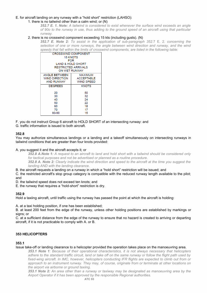
E. for aircraft landing on any runway with a “hold short” restriction (LAHSO):1. there is no tailwind other than a calm wind; or (N)
352.7 E. 1. Note: A tailwind is considered to exist whenever the surface wind exceeds an angle of 90o to the runway in use, thus adding to the ground speed of an aircraft using that particular runway.
2. there is no crosswind component exceeding 15 kts (including gusts). (N)352.7 E. Note 2: To assist in the application of sub-paragraph 352.7 E. 2. concerning the selection of one or more runways, the angle between wind direction and runway, and the wind speeds that fall within the limits of crosswind components, are listed in the following table:
F. you do not instruct Group 6 aircraft to HOLD SHORT of an intersecting runway: andG. traffic information is issued to both aircraft.
352.8You may authorize simultaneous landings or a landing and a takeoff simultaneously on intersecting runways in tailwind conditions that are greater than four knots provided:
A. you suggest it and the aircraft accepts it; or352.8 A.Note 1: A request to an aircraft to land and hold short with a tailwind should be considered only for tactical purposes and not be advertised or planned as a routine procedure.352.8 A. Note 2: Clearly indicate the wind direction and speed to the aircraft at the time you suggest the landing AND with the landing clearance.
B. the aircraft requests a landing on a runway in which a “hold short” restriction will be issued; andC. the restricted aircraft's stop group category is compatible with the reduced runway length available to the pilot; andD. the tailwind speed does not exceed ten knots; andE. the runway that requires a “hold-short” restriction is dry.
352.9Hold a taxiing aircraft, until traffic using the runway has passed the point at which the aircraft is holding:
A. at a taxi holding position, if one has been established;B. at least 200 feet from the edge of the runway, unless other holding positions are established by markings or signs; orC. at a sufficient distance from the edge of the runway to ensure that no hazard is created to arriving or departing aircraft, if it is not practicable to comply with A. or B.
353 HELICOPTERS
353.1Issue take-off or landing clearance to a helicopter provided the operation takes place on the manoeuvring area.
353.1 Note 1: Because of their operational characteristics, it is not always necessary that helicopters adhere to the standard traffic circuit, land or take off on the same runway or follow the flight path used by fixed-wing aircraft. In IMC, however, helicopters conducting IFR flights are expected to climb out from or approach to an instrument runway. They may, of course, originate from or terminate at other locations on the airport via airborne or ground taxiing.353.1 Note 2: An area other than a runway or taxiway may be designated as manoeuvring area by the Airport Operator if it has been approved by the responsible Regional authorities.
ATC 93

353.2If a helicopter intends to take off or land outside the manoeuvring area:
353.2 Phraseology:(aircraft identification)(unit identification, if required) (special information, such as traffic, hazard or obstruction)(control instructions, such as departure routing or turn after takeoff)(wind information, if required) TAKE OFF AT YOUR DISCRETION (location)— or —(Control instructions)(traffic or other information) LAND AT YOUR DISCRETION.353.2 Example:GOLF JULIETT ALFA DELTA, TRAFFIC CHEROKEE DEPARTING RUNWAY 31, HOLD SHORT OF RUNWAY 31, WIND 300 AT 15 TAKE OFF AT YOUR DISCRETION FROM APRON 4.
A. provide instructions and traffic information, as necessary, for control purposes; andB. inform the aircraft that landing or takeoff will be at the pilot's discretion.
353.3 Include the specific route in a clearance to or from the landing area to ensure safe conformance with, or avoidance of other airport traffic, as necessary.
353.4Clear helicopters to air taxi unless:
353.4 Phraseology:CLEARED TO AIR TAXI or AIR TAXI, VIA (route), TO (location), (restrictions and special instructions as necessary), (traffic information, wake turbulence and other hazards), (wind information if required).353.4 Note 1: Due to the possible absence of visual cues to the pilot, caution is required when authorizing helicopter taxi operations at night or during daylight periods when ceiling or visibility is below VFR minima. It may be preferable in these circumstances for the helicopter to operate in the hover mode over lightedportions of the movement area.353.4 Note 2: Air taxi is the preferred method for helicopter movements on airports provided ground operations and conditions permit. Air taxi authorizes the pilot to proceed above the surface either via hover taxi or flight at speeds more than 20 knots. Unless otherwise requested or instructed, the pilot is expected to remain below 100 feet AGL. The pilot is solely responsible for selecting a safe airspeed and altitude for the operation being conducted.
A. the aircraft has specifically requested clearance to hover taxi or taxi on the surface; orB. the Regional Manager, Safety and Service Design has directed that helicopters are to taxi only via the hover mode in specified situations.
353.5Do not issue an air taxi or hover taxi clearance that will knowingly require a helicopter to pass over persons, vehicles, or aircraft.
353.6Include explicit route details in an air taxi or hover taxi clearance, if necessary, due to traffic or known ground hazards.
353.7At those locations where air taxi or hover taxi routes have been designated under the authority of the Regional Manager, Safety and Service Design clear helicopters along these routes in accordance with direction issued for their use.
353.8 Apply appropriate wake turbulence procedures to helicopters during air taxi or hover taxi as though they were departing aircraft.
353.9Avoid requiring frequency changes by helicopters known to be single-piloted while air taxiing, hovering or flying at low level.
354 PEDESTRIANS AND VEHICLES
354.1Keep ground traffic, such as pedestrians, vehicles, or construction equipment, away from taxiing aircraft.
ATC 94

354.2Hold ground traffic:A. at least 200 feet from the edge of an active runway, unless other holding positions are established by markings or signs; orB. at a sufficient distance from the edge of the runway to ensure that no hazard is created to arriving or departing aircraft, if it is not practicable to comply with A.
354.3Inform concerned aircraft of the circumstances if:
354.3 Note: This may be necessary during certain operations, such as construction, maintenance, or flight checks.
A. ground traffic is located less than 200 feet from the edge of the runway in use, unless other holding positions are established by markings or signs closer than 200 feet; andB. it is not practicable to close the runway.
354.4Take extra care at night and during periods of restricted visibility to ensure that:
A. the runway is clear for use when required; andB. information concerning the location of ground traffic is maintained by restricting vehicle movements to a particular runway, taxiway or other specific area on the airport.
354.5Do not use words and terms “go ahead”, “clear” or “cleared” in radiotelephony communications for ground vehicle operations.
354.6Respond to a radio call from a vehicle operator in the following form: A. (Vehicle identification).B. Unit function.C. STATE YOUR REQUEST or WHAT ARE YOUR INTENTIONS.
354.7Instruct a vehicle to either “cross” or “hold short” of any runway it will cross while on the manoeuvring area.
354.8Issue vehicle movement instructions as follows:A. (Vehicle identification).B. PROCEED VIA (route), (if applicable), CROSS RUNWAY (number) or PROCEED ONTO RUNWAY (number) TO (destination other than a runway), HOLD SHORT OF (runway, taxiway, other). (N)(R)
354.8 B. Note: Do not use the word “TO” in the route if a vehicle's destination is a runway.C. LEAVE, EXIT, GET OFF RUNWAY (number) AT (location) AND REPORT/ADVISE WHEN OFF THE RUNWAY.
354.9Precede a refusal or delay to a request, with the word “NEGATIVE” followed by further instructions and if necessary, the reason.
354.9 Phraseology:NEGATIVE HOLD YOUR POSITION (reason).— or —NEGATIVE HOLD SHORT OF RUNWAY (number) (reason).
354.10Use the direction contained in 316.3 to control aircraft and the movement of vehicles, equipment and personnel on the manoeuvring area when radio communications cannot be employed.
354.11If all other forms of communication fail, you may flash the runway lights on and off as a signal to vehicles and pedestrians to vacate the active runway.
ATC 95

360 COORDINATION
361 REPORTS
361.1Except as provided in 361.2, keep IFR units promptly advised of pertinent information concerning IFR or CVFR aircraft, including the following items:
A. arrival or control transfer times; 361.1 A. Note: If an exemption is stated in an Arrangement and the IFR unit is satisfied that radar-displayed information at the control transfer point is adequate, the Control Tower does not need to inform the IFR unit of an arrival or control transfer time.
B. cancellation or closure of IFR flight plan time; 361.1 B. Note: When an IFR aircraft informs the tower controller it is canceling IFR and intending to land at an aerodrome where there is not an operating air traffic control unit or flight service station, the controller shall follow the procedure contained in 404.2.
C. departure times when needed. Departure times may be forwarded verbally or via electronic means.D. position reports when needed;E. missed approach times when needed; andF. available information relating to overdue or unreported aircraft.
361.2You may omit passing arrival or control transfer times if:
A. the exemption is stated in an agreement; andB. a PSR is located on or in close proximity to the airport in use.
361.3NOT APPLICABLE
361.4When required by local regulations, report the departure and arrival times of VFR aircraft, for which a flight plan or a flight itinerary has been filed, to the appropriate ACC or FSS.
361.4 Note: For this purpose, the time an aircraft joins the traffic circuit is considered the arrival time.
361.5Coordinate with the appropriate IFR unit to determine the action to be taken if a VFR aircraft states that it has encountered, or is about to encounter, IMC
361.6Coordinate fully with all operating positions concerned if:A. an active runway is changed;B. there is to be a landing or takeoff on arunway other than the active; orC. a greater approach interval is required to assist in expediting the movement of airport traffic.
361.7Do not authorize ground traffic to operate on a runway being used for landing and takeoff unless you have coordinated with the airport controller.
361.8Take action to display, at operating positions, the status of any runway on which sanding, ploughing, sweeping, calibration, inspection, maintenance or any similar operation has been approved that will affect its availability to landing and departing traffic.
362 CONTROL TRANSFER
362.1Transfer responsibility for control of an aircraft between the ground controller and the airport controller in accordance with locally developed procedures.
362.2
ATC 96

The responsibility for control of a departing IFR or CVFR aircraft is automatically transferred from the tower to the appropriate IFR unit, as soon as the aircraft is airborne unless otherwise coordinated.
362.3The responsibility for control of an arriving IFR or CVFR aircraft is automatically transferred from the IFR unit to the tower, as soon as the aircraft has landed unless otherwise coordinated.
362.3 Note: An aircraft that cancels or closes its IFR flight plan automatically becomes a VFR flight.
362.4Request control of an arriving IFR or CVFR aircraft in the following form:
A. REQUEST CONTROL OF (aircraft identification).B. NOW/AT (specific point).
362.5You may assume responsibility for control of an arriving IFR or CVFR aircraft that has been cleared for an approach provided:
A. VFR conditions exist at the airport;B. you have sighted the aircraft and are satisfied that it will remain in sight and not have to return to IFR conditions;
362.5 B. Note: At locations where a Tower Radar Plan exists and a transfer of control is effected in accordance with an inter-unit arrangement, there is no need to have sighted the aircraft.
C. the aircraft intends to land and not continue on an IFR clearance; and (N)362.5 C. Note: Control transfer cannot be effected if the aircraft conducting the approach has indicated no intention of landing upon completion of the approach and will continue to operate on an IFR clearance, i.e., the aircraft will execute a missed approach, perform another instrument approach or proceed to another location.
D. the aircraft is at a position within the control zone/or the Tower Radar Area agreed upon by:1. you and the IFR controller when you requested control; or2. both units as specified in an arrangement.
362.6Forward a control transfer time in the following form: A. (Aircraft identification).B. MY CONTROL.C. NOW/AT (specific time).
363 COMMUNICATION TRANSFER
363.1
When a change of frequency is required, instruct the aircraft to contact or monitor: 363.1 Phraseology:CONTACT/MONITOR (unit/function/agency) ON (frequency) NOW/AT (time) AT/OVER (location/fix).363.1 Note: During an emergency, the aircraft may be required to contact the AFF on the DEF or change to the ECC frequency as outlined in an agreement.
A. a specified unit/function/agency; B. on a specified frequency; andC. 1. now;
2. at a specified time;3. at a specified location on the airport; or
363.1 C. 3. Note: The term “holding short” can be used as a location for the purpose of communication transfer and does not require a readback.
4. over a specified fix.
363.2Normally, do not release a VFR aircraft from the tower frequency while operating in the control zone.
363.3You may release a VFR aircraft from tower frequency without specifying another frequency provided the aircraft is leaving the control zone.
ATC 97

363.4Change an IFR or CVFR aircraft to the frequency of the IFR unit or to the frequency specified in the IFR or CVFR clearance if:
363.4 Phraseology:CONTACT (name) DEPARTURE (frequency) NOW/ AT (time)/OVER (location). CHANGE TO (name) CENTRE (frequency) NOW/ AT (time)/OVER (location).
A. direct communication can be established on the IFR frequency; andB. the aircraft is at a point agreed upon by both units.
363.5You may release an IFR or CVFR aircraft from tower frequency without specifying another frequency provided:
363.5 Phraseology:CHANGE TO EN ROUTE FREQUENCY NOW/AT (time)/OVER (location).A. the aircraft is leaving the control zone; andB. direct communications cannot be established on the IFR frequency.
ATC 98

370 AIRPORT LIGHTING
371 GENERAL
371.1NOT APPLICABLE
ATC 99

380 WAKE TURBULENCE
381 APPLICATION
381.1Except as stipulated in 384, apply the appropriate wake turbulence separation minimum to: (N)(R)
381.1 Note: There are no wake turbulence non-radar minima for arriving or en route aircraft. Only in a radar environment are normal IFR separation minima less than required for wake turbulence.
A. any category aircraft that takes off into the wake of a known heavy aircraft; and when specified 381.1 A. Note: For the purpose of wake turbulence application, the Boeing 757 and Boeing 737NG winglets are to be considered a heavy when it is the preceding aircraft.
B. a light aircraft that takes off into the wake of a known medium aircraft.
382 MINIMA
382.1
Apply 2 minutes separation to any category aircraft that takes off into the wake of a known heavy aircraft on: 382.1 Note: An aircraft in the departure phase of a stop-and-go or a touch-and-go is treated as a takeoff.382.1 Diagram:
A. the same runway; orB. a parallel runway less than 2,500 feet away. LESS THAN 2,500 FEET
382.2Apply 3 minutes separation to any category aircraft that takes off into the wake of a known heavy aircraft or a light aircraft that takes off into the wake of a medium aircraft if:
ATC 100

382.2 Diagram:
A. the following aircraft starts its take-off roll from an intersection or a point significantly further along the runway, in the direction of takeoff, than the preceding aircraft; orB. you have reason to believe that rotation may occur beyond the rotation point of the preceding aircraft.
382.3If the projected flight paths will cross, apply 2 minutes to any category aircraft that takes off behind a heavy aircraft that has taken off or is doing a low or missed approach on:
382.3 Diagram:
A. a crossing runway; orB. a parallel runway 2,500 feet or more away.
382.4If aircraft utilize the same runway or a parallel runway less than 2,500 feet away, apply 3 minutes separation to any category aircraft that takes off after a heavy or heavier category aircraft has overflown the runway in the same or opposite direction.
382.4 Note: For the purpose of wake turbulence application, a heavier aircraft that takes off in the opposite direction is considered to have effected a low or missed approach.
ATC 101

382.4 Diagram 1:
382.4 Diagram 2:
382.5When applying a wake turbulence radar minimum to a departing aircraft ensure that the appropriate radar minimum exists when the following aircraft becomes airborne.
383 WAKE TURBULENCE AVOIDANCE
383.1INTENTIONALLY BLANK
383.2If a helicopter is hovering or is airborne while taxiing, you should keep it well clear of light aircraft.
383.2 Note: Helicopters produce rotor downwash if hovering and vortices if in forward flight.
383.3Provide information concerning wake avoidance if you consider it necessary.
383.3 Note 1: Watch for:A. calm winds and stable air;B. a light crosswind or tailwind that could keep a vortex on the runway; orC. turbulence drifting to another runway.383.3 Note 2: An aircraft operating behind an aircraft that has taken off can avoid the vortex: A. if landing, by touching down before the rotation point of the heavier aircraft; orB. if taking off, by rotating before the rotation point of the heavier aircraft and climbing out above its flight path.383.3 Note 3: An aircraft operating behind an aircraft that has landed can avoid the vortex:A. if landing, by remaining above the flight path of the heavier aircraft and touching down beyond its touchdown point; or
ATC 102

B. if taking off, by rotating beyond the touchdown point of the heavier aircraft.383.3 Diagram 1:
383.3 Diagram 2:
383.4You should clear a lighter category aircraft for takeoff first in order to avoid wake turbulence if:A. the lighter and heavier aircraft are both ready for takeoff at the same time; andB. no undue delay will be created for the heavier category aircraft. (N)
383.4 B. Note: For example, it may be possible to avoid undue delay by issuing a turn after takeoff to ensure expeditious clearing of the flight path.
384 AIRCRAFT INITIATED WAIVER
384.1Issue take–off clearance to an aircraft that has waived wake turbulence separation, except, if it is a light or medium aircraft departing:
384.1 Note: Controllers may consider an aircraft initiated waiver as acceptance of responsibility for wake turbulence separation.
A. behind a heavy aircraft and takeoff is started from an intersection or a point significantly further along the runway, in the direction of takeoff;B. behind a heavy aircraft that is taking off or making a low or missed approach in the opposite direction on the same runway; orC. behind a heavy aircraft that is making a low or missed approach in the same direction on the same runway.
384.2Issue wake turbulence cautionary information prior to clearing the aircraft for takeoff.
384.2 Phraseology:CAUTION! POSSIBLE TURBULENCE FROM DEPARTING (type of aircraft).
ATC 103
390 RADAR SERVICE
391 APPLICATION
391.1Provide radar service to aircraft in accordance with a Tower Radar Plan in effect for the unit according to local regulations.
391.2Apply the applicable rules and procedures contained in ATC MANOPS Part 5 as supplemented by this Section and the Tower Radar Plan for the unit when providing radar service to aircraft operating in areas designated by the Tower Radar Plan.
391.3Use caution when issuing headings or assigning altitudes to VFR aircraft.
391.4Identify VFR aircraft, in accordance with ATC MANOPS 511, prior to providing radar service.
391.5Inform aircraft if radar service: (P)
391.5 Phraseology:UNABLE TO PROVIDE RADAR SERVICE (reason)RADAR SERVICE TERMINATED. CHANGE TOFREQUENCY (en route frequency) (or other special instructions).
A. cannot be provided; or B. is terminated.
391.6Issue position information and traffic information, as necessary, to assist aircraft in establishing visual separation from other aircraft. (N)(R)
391.6 Note: Traffic information to aircraft may be based on other radar observed aircraft that in your judgment constitute a hazard.
391.7You may vector an aircraft within the control zone or a Tower Radar Area to establish visual separation or approach sequence provided a special service, including the provision of vectoring, is established in accordance with a Tower Radar Plan, if:
391.7 Note: Accepting a vector does not relieve a VFR aircraft of its responsibility for:A. avoiding other aircraft;B. avoiding flight in IMC; andC. maintaining adequate obstacle clearance.
A. the aircraft requests it;B. you suggest it and the aircraft accepts it; orC. you consider it necessary for flight safety.
391.8You may vector an IFR aircraft within the control zone or a Tower Radar Area provided:A. responsibility for control has been transferred to the tower; and B. one of the conditions specified in 391.7 is met.
391.9You may assign an altitude to a VFR aircraft if you consider it necessary.
391.10Do not use a turn to identify an IFR aircraft unless responsibility for control has been transferred to the tower. (R)
391.11Do not vector or assign an altitude to a SVFR aircraft.
391.12Promptly cancel restrictions issued to VFR aircraft if:
ATC 104

391.12 Phraseology:(Aircraft ident) ALTITUDE RESTRICTION IS CANCELLED MAINTAIN VISUAL SEPARATION FROM (aircraft type).
A. they are no longer required; orB. visual separation has been achieved.
391.13You may issue speed adjustment instructions as an aid to establish visual separation provided you do not assign an IAS.
391.13 Phraseology:REDUCE TO APPROACH SPEED.INCREASE/REDUCE SPEED AS MUCH AS PRACTICABLE.MAINTAIN PRESENT SPEED.RESUME NORMAL SPEED.
391.14Express a speed adjustment in units or multiples of 10 knots, based on IAS.
391.14 Note: Aircraft complying with speed adjustments are expected to maintain a speed within plus or minus 10 knots of the specified speed.
391.15Do not apply speed adjustment instructions to IFR or CVFR aircraft except if:A. you have assumed responsibility for control; or B. coordination has been effected with the IFR unit.
392 SEPARATION
392.1Separate CVFR aircraft in Class B airspace above 12,500 feet ASL by standard IFR separation. (FAA)
392.2Separate CVFR aircraft in Class B airspace 12,500 feet ASL and below in accordance with ATC MANOPS 392, 393, 532.1 D. or 532.1 E. as applicable. (FAA)
392.3Aircraft that report sighting their traffic are considered visually separated. Further clearances or instructions may be issued to the aircraft in relation to the traffic.
392.3 Phraseology:(Aircraft ident) NUMBER THREE FOLLOW THE (aircraft type).— or —(Aircraft ident) PASS BEHIND THE (aircraft type) AND PROCEED ON COURSE.
392.4Aircraft are considered visually separated when the tower controller visually sights the aircraft and no conflict exists.
392.5Aircraft that have reported over separate, clearly defined geographical points and their intended routes of flight will not conflict thereafter, are considered separated.
393 MINIMA
393.1In the provision of separation or conflict resolution, separate aircraft vertically by a minimum of 500 feet unless additional separation is required for wake turbulence.
393.1 Note: 500 feet vertical separation need not be applied when aircraft are separated visually as stipulated in
393.2When providing separation or conflict resolution using a tower radar display, apply target resolution separation, by ensuring PPS do not touch, provided:
ATC 105

393.2 Note 1: Target resolution separation need not be applied when aircraft are separated using one of the methods outlined in 392 or 393.1 of ATC MANOPS.393.2 Note 2: The appropriate minimum radar separation for wake turbulence must be applied to radar vectored aircraft until visual separation is established. When visual separation is established, a cautionary is issued.
A. at least one of the aircraft is VFR;B. a maximum of 20 miles is displayed on the radar display;C. mode C altitude information is displayed for both aircraft; orD. if mode C is not displayed on both aircraft, the aircraft are 3,000 feet Above Airport Elevation or below; andE. when using DSE, the position of the centre of the radar display is such that the maximum range the service can be provided to does not exceed 20 miles from the RSE.
393.3If a unit does not meet all the requirements of 393.2, use a minima described in 532.1 when providing separation or conflict resolution using a tower radar display.
393.4In the application of 532.1 a maximum range of 20 miles is to be utilized on the Tower Radar Display.
394 CONFLICT RESOLUTION
394.1Conflict resolution only applies in a radar environment.
394.1 Note:In the provision of conflict resolution, target resolution or 500 feet vertical separation need not be applied if, after receiving traffic information, one of the aircraft reports the traffic in sight or, in the controller's judgment, the aircraft will not conflict.
394.2In Class C airspace, provide conflict resolution between IFR and VFR aircraft and upon pilot request between VFR aircraft.
394.3If equipment and workload permit, in Class D airspace, provide conflict resolution between IFR and VFR aircraft and upon request between VFR aircraft.
394.3 Note:A facility which is equipped with a commissioned radar is deemed to meet the equipment requirements to provide conflict resolution.
394.4When providing conflict resolution, if unable to apply visual separation, apply a minimum contained in ATC MANOPS 393 or 532.1.
ATC 106

PART 4 — AREA AND TERMINAL CONTROL
400 _ GENERAL
401 PROVISION OF SERVICE402 SPECIAL VFR403 RESTRICTION OF VFR404 CLOSING AND CANCELING IFR FLIGHT PLANS OR FLIGHT ITINERARIES405 TRAFFIC INFORMATION406 POSITION REPORTS407 ALTIMETER SETTINGS
410 _ CLEARANCES
411 GENERAL412 FORMAT413 ALTERNATE INSTRUCTIONS414 COMPOSITE FLIGHT PLANS415 AMENDMENTS416 RELAY
420 _ CLEARANCE LIMITS AND ROUTES
421 CLEARANCE LIMITS422 ROUTE DESCRIPTION423 LOCAL FLIGHTS424 LEAVING OR ENTERING CONTROLLED AIRSPACE425 FLIGHT OF SHORT DURATION426 INSTRUMENT APPROACHES EN ROUTE
430 _ ALTITUDE ASSIGNMENT
431 GENERAL432 DIRECTION OF FLIGHT433 MINIMUM ALTITUDES434 SEPARATION BETWEEN FLIGHT LEVELS AND ALTITUDES ASL435 ONE THOUSAND ON TOP436 VFR CLIMB/DESCENT437 ALTITUDE REPORTS438 CONTROLLED VFR
440 _ DEPARTURES
441 CLEARANCES442 STANDARD INSTRUMENT DEPARTURES443 RELEASE TIME444 VFR RELEASE OF AN IFR AIRCRAFT445 DELAYS
450 _ HOLDING
451 HOLDING AREAS452 HOLDING FIXES453 HOLDING PATTERNS454 CLEARANCES455 SEQUENCING
460 _ ARRIVALS
461 LANDING INFORMATION462 EN ROUTE DESCENT
ATC 107

463 CLEARANCE LIMIT464 APPROACH SEQUENCES465 APPROACH CLEARANCES466 CONTACT APPROACH
470 _ SEPARATION
471 APPLICATION472 VERTICAL SEPARATION473 LATERAL SEPARATION474 LONGITUDINAL SEPARATION475 INITIAL SEPARATION476 SEPARATION FROM CLASS F AIRSPACE477 SEPARATION FROM AIRSPACE RESTRICTED BY THE MINISTER478 SEPARATION FROM PHOTOGRAPHIC SURVEY AIRCRAFT
480 _ RNPC
481 RNPC GENERAL482 RNPC VERTICAL SEPARATION483 RNPC LATERAL SEPARATION484 RNPC LONGITUDINAL SEPARATION485 RNPC LONGITUDINAL SEPARATION — MACH-NUMBER TECHNIQUE486 RNPC PARALLEL OFFSET PROCEDURES - NON-RADAR ENVIRONMENT
490 _ COORDINATION
491 FLIGHT DATA TRANSFER492 IFR UNIT — IFR UNIT493 IFR UNIT — TOWER AND FLIGHT SERVICE STATION494 COMMUNICATION TRANSFER495 CONTROL TRANSFER496 AIRCRAFT DIVERSIONS
ATC 108

PART 4 — AREA AND TERMINAL CONTROL
400 GENERAL
401 PROVISION OF SERVICE
401.1The objective of IFR control service is to maintain a safe, orderly, and expeditious flow of air traffic under the control of an IFR unit.
401.2Provide IFR control service to:A. IFR aircraft operating within controlled airspace; andB. VFR aircraft operating within Class A airspace and within Class B airspace.
401.2 B. Note: Some countries permit VFR operations in Class A airspace if an authorization has been issued by the local authorities.
401.3You may regulate the number of aircraft to a number that you can control safely and efficiently by:
401.3 Note: Only Division Staff has the authority to restrict or suspend access to airspace.A. instructing aircraft to hold on the ground or in the air;B. informing an adjacent sector or unit that approval will be required before an aircraft is allowed to enter your area of responsibility; orC. doing both A. and B.
402 SPECIAL VFR
402.1Within a control zone where there is an airport controller on duty, specify the period of time during which SVFR flight is approved.
402.1 Note: The airport controller is responsible for authorizing each individual aircraft.
402.2Approve or refuse to approve a tower's request for SVFR on the basis of current or anticipated IFR traffic only.
402.2 Phraseology:SPECIAL VFR IS APPROVED (altitude restriction if required) IN THE (name) CONTROL ZONE UNTIL (time)/FROM (time) TO (time). SPECIAL VFR IS APPROVED IN (specified portion) OF THE (name) CONTROL ZONE UNTIL (time)/ FROM (time) TO (time).
402.3Authorize or refuse to authorize an aircraft's request for SVFR on the basis of: (R)A. current or anticipated IFR traffic; orB. current weather conditions. (N)
402.3 B. Note: The typical visibility minima for SVFR are:A. 1 mile for fixed wing aircraft; andB. 1/2 mile for rotorcraft.This could be modified by local procedures.
402.4Within a control zone where there is no airport controller on duty, take one of the following actions:
402.4 Note: Communication with ATC may occur by DCPC, or through a FSS.A. Authorize one or more SVFR aircraft.
402.4 A. Phraseology:SPECIAL VFR IS AUTHORIZED FOR (aircraft ident) TO OPERATE WITHIN/ENTER/EXIT/PASSTHROUGH THE (name) CONTROL ZONE, (additional instructions, as necessary).
B. Authorize SVFR for a specified period of time. 402.4 B. Phraseology:SPECIAL VFR IS AUTHORIZED IN THE (name) CONTROL ZONE UNTIL (time), (additional instructions, as necessary).
ATC 109

C. Refuse authorization provided you inform the FSS or the aircraft of the reason. 402.4 C. Phraseology:UNABLE SPECIAL VFR (reason).
402.5With the exception of helicopters, do not authorize SVFR aircraft to depart or transit the zone at night.
403 RESTRICTION OF VFR
403.1You may restrict or suspend VFR operations within a control zone or a Tower Radar Area if a NOTAM has been issued.
404 CLOSING AND CANCELING IFR FLIGHT PLANS OR FLIGHT ITINERARIES
404.1If an aircraft informs you that it is closing an IFR flight plan or flight itinerary while airborne or on the ground:
404.1 Note: An aircraft's decision to close an IFR flight plan or flight itinerary is not subject to approval by ATC.
A. acknowledge the closure;B. if you know that the aircraft is operating in an airspace where VFR flight is not permitted, because of the airspace classification or current weather conditions, inform the aircraft;
404.1 B. Note: You are expected to pass the most current weather sequence and ask the aircraft its intentions.
C. inform the aircraft that flight plan alerting service is terminated; and 404.1 C. Phraseology:CHECK CLOSING IFR FLIGHT PLAN or FLIGHT (ITINERARY) ALERTING SERVICE IS TERMINATED.
D. notify the agency responsible for alerting service at the destination.
404.2If an aircraft informs you that it is cancelling IFR: (N)
404.2 Note 1: An aircraft's decision to cancel an IFR flight plan or flight itinerary or change to a VFR flight plan or flight itinerary is not subject to approval by ATC.404.2 Note 2: By regulation, the phrase “cancelling IFR” does not close the flight plan or flight itinerary.
A. acknowledge the cancellation;B. ask the aircraft if it is closing the IFR flight plan or flight itinerary; and
404.2 B. Phraseology:CHECK CANCELLING IFR ARE YOU CLOSING YOUR FLIGHT PLAN or FLIGHT ITINERARY?1. if the aircraft confirms closing the flight plan advise the aircraft that alerting service is terminated; or
404.2 B. 1. Phraseology:CHECK CLOSING IFR FLIGHT PLAN or FLIGHT ITINERARY ALERTING SERVICE IS TERMINATED.
2. if the aircraft informs you that it is cancelling IFR but not closing the flight plan or flight itinerary advise the aircraft that an arrival report is required after landing.
404.2 B. 2. Phraseology:BE ADVISED THAT AN ARRIVAL REPORT IS REQUIRED AFTER LANDING.
C. if you know that the aircraft is operating in an airspace where VFR flight is not permitted, because of the airspace classification or current weather conditions, inform the aircraft.
404.2 C. Note: You are expected to pass the most current weather sequence and ask the aircraft its intentions.
404.3If an aircraft informs you that it is changing to a VFR flight plan and a composite IFR-VFR flight plan has not been filed:A. obtain the following information and change the FPL if able:
1. aircraft destination;2. ETA; and
B. if you know the aircraft is operating in an airspace where VFR flight is not permitted, because of the airspace classification or current weather conditions, inform the aircraft.
404.3 B. Note: You are expected to pass the most current weather sequence and ask the aircraft its intentions.
ATC 110

405 TRAFFIC INFORMATION
405.1Issue traffic information to all concerned aircraft if: A. you clear an aircraft to maintain “at least 1,000 feet on top”; B. you clear an IFR aircraft to fly in accordance with VFR; C. an aircraft requests it; orD. you consider it necessary.
405.2Inform aircraft cleared to hold of other aircraft holding at the same fix unless they will be separated by more than the vertical separation minimum.
405.2 Phraseology:TRAFFIC (type of aircraft) HOLDING AT (fix) MAINTAINING (altitude).
406 POSITION REPORTS
406.1Include a request for a position report in a clearance if you require a report other than one that will be made over a designated compulsory reporting point.
406.2You should not request an aircraft operating in the HLA to report over a reporting point that is not depicted on a high-level en route chart.
406.3You may instruct an aircraft:A. to report leaving or passing a reporting point; and
406.3 A. Phraseology:REPORT LEAVING/PASSING (reporting point).
B. to forward any other information you require.
406.4Do not request an aircraft to pass the same position report to more than one ATS facility.
407 ALTIMETER SETTINGS
407.1If an en route aircraft operating within the Altimeter Setting Region makes a position report via DCPC, issue the current altimeter setting for: A. the station over which the aircraft reports; andB. the next station along the route of flight.
407.2If an aircraft will proceed from the Standard Pressure Region to the Altimeter Setting Region, issue the current altimeter setting before the transition occurs.
ATC 111

410 CLEARANCES
411 GENERAL
411.1Do not accept responsibility for separating aircraft in Class G airspace.
411.2Issue clearances and instructions that ensure an aircraft will remain within controlled airspace unless the aircraft requests otherwise.
411.2 Note: This may necessitate detailed instructions, such as the heading, or radial to fly, especially during climb or descent.
411.3If you accept an abbreviated flight plan in order to issue a clearance, inform the aircraft that a complete flight plan must still be filed with FSS.
412 FORMAT
412.1Issue clearance items, as appropriate, in the following order:
412.1 Note: It is important that an IFR clearance contain positive and concise data phrased in a consistent manner. This is especially true of a clearance that will be relayed through a communication agency, since the clearance must be relayed verbatim.
A. Prefix.B. Aircraft identification.C. Clearance limit.D. SID.E. Route.F. Altitude.G. Mach-number.H. Departure, en route, approach, or holding instructions.I. Special instructions or information.J. Traffic information.
413 ALTERNATE INSTRUCTIONS
413.1Issue alternate instructions if:
413.1 Phraseology:IF NOT POSSIBLE, (alternate instructions) AND ADVISE.
A. you clear an IFR aircraft to fly in accordance with VFR and there is a possibility that VFR flight may become impossible; B. failure of an unmonitored precision approach aid could result in inadequate separation or endanger the safety of aircraft; or C. you consider that a possibility exists that the aircraft may be unable to comply with a clearance or instruction.
413.1 C. Note: Failure of an underlying navigational aid associated with a procedure may prevent an aircraft from complying with a clearance or instruction.
414 COMPOSITE FLIGHT PLANS
414.1Instruct an aircraft that has filed VFR for the first part of a flight and IFR for the last part to contact the appropriate ATC unit for clearance, approaching the point where the IFR part of the flight begins.
414.2Clear an aircraft that has filed IFR for the first part of a flight and VFR for the last part to the point at which the IFR part of the flight ends.
ATC 112
415 AMENDMENTS
415.1You may issue a clearance amending a previous clearance.
415.1 Note: The last clearance issued has precedence over and cancels any related item of a previous clearance.
415.2If it is necessary to amend a previously issued clearance, use one of the following:A. If amending the route:
415.2 A. Example:CDN92 CLEARED TO THE WINNIPEG AIRPORT VIA PRINCETON, J504 LUMSDEN, REMAINDER OF ROUTE UNCHANGED;— or —CDN92 CLEARED TO THE WINNIPEG AIRPORT VIA PRINCETON, J504 LUMSDEN, J500 LANGRUTH, J515 WINNIPEG.In this case CDN92 had been cleared to the Winnipeg Airport via J500 Langruth J515 Winnipeg. Before reaching Princeton, the aircraft was rerouted via Princeton J504 Lumsden J500 Langruth J515 Winnipeg.1. state the amendment to the route and, if applicable, state that the rest of the route is unchanged; or2. issue the entire route.
B. If amending the altitude: 415.2 B. Example:ACA506 MAINTAIN 15,000 CROSS KATSY AT 7,000 OR BELOW, CROSS NORCH AT 9,000 OR ABOVE;— then —ACA506 MAINTAIN 17,000, PREVIOUS RESTRICTIONS UNCHANGED.In this case ACA506 had flight planned 17,000, was restricted to 15,000 with crossing restrictions at KATSY and NORCH intersections. Before reaching KATSY 17,000 became available.1. restate all applicable altitude restrictions; or2. state that applicable altitude restrictions are still in effect.
C. If amending both route and altitude, ensure that the conditions listed in both 415.2 A. and B. are met.
415.3Identify and correct any error made during transmission of a clearance or instruction. Cancel and restate the clearance in full if there is any possibility of misunderstanding.
415.4 If you approve a requested change in flight plan, include the exact nature of the change in the clearance.
415.5If you are unable to approve a requested change in flight plan:A. inform the aircraft that you are unable; andB. include:
1. the reason for non-approval; and2. a suggested alternative if practicable.
416 RELAY
416.1If a communication agency informs you that a clearance has not been delivered, instruct the agency to take one of the following actions:
416.1 Note: It is the responsibility of the communication agency to which a clearance is issued to transmit it to the aircraft immediately upon receipt, unless an attempt-delivery time has been specified. The controller will be notified if the clearance is not delivered within 3 minutes after receipt, or of the attempt-delivery time when specified.
A. To continue attempting to deliver and to report if undelivered by a specified time.B. To attempt to deliver at a specified time.C. To cancel the clearance.
ATC 113

420 CLEARANCE LIMITS AND ROUTES
421 CLEARANCE LIMITS
421.1At least 5 minutes before an aircraft reaches its clearance limit, issue:
421.1 Note 1: If a clearance is not received, the aircraft is expected to hold in a published holding pattern or if there is no published pattern, a standard pattern on the inbound track to the clearance limit and to request further clearance or an approach clearance. If communication cannot be established with ATC, the aircraft is then expected to proceed in accordance with communication failure rules and procedures.421.1 Note 2: An arriving aircraft, which has filed an RNAV STAR, is expected to fly this route, as cleared, to the terminal area entry fix (bedpost) or fix associated with the RNAV STAR. If no further clearance has been received upon reaching that point, the pilot is expected to fly the lateral route of the RNAV STAR for the instrument approach(es) serving the runway(s) in use, as specified on the ATIS, maintaining the last assigned altitude. In the event of a communication failure the pilot is expected to squawk 7600, fly the RNAV STAR as published, including the vertical and speed requirements as depicted in the procedure, intercept the final approach, fly inbound land as soon as possible.
A. a further clearance;B. an approach clearance; orC. a holding clearance.
421.1 C. Note: A late clearance may cause an aircraft to overshoot the holding fix.
421.2You should inform a high-performance aircraft if you anticipate that it may be required to hold en route or during descent.
421.2 Note: Aircraft require time to make any necessary adjustments needed to prepare for a restriction. For example, an aircraft could overshoot the holding area if it enters the holding pattern at a speed exceeding the applicable maximum holding speed.
422 ROUTE DESCRIPTION
422.1Specify the name of the departure airport as the first element of the route if you issue a departure clearance:
422.1 Phraseology:VIA TERRACE, FLIGHT PLANNED ROUTE. VIA SEPT ILES, DIRECT (location), FLIGHT PLANNED ROUTE.
A. through an FSS; orB. directly to an aircraft on the ground using DCPC.
422.2Issue a detailed route description as necessary.
422.2 Phraseology:VIA (airway designators).VIA (fix) AND (fix).(Fix) DIRECT (fix).CROSS/JOIN (airway designator)(number) MILES (direction) OF (fix).
422.3You may use the phrase “via flight planned route” provided:A. the previously filed route has not been changed;B. the flight plan is not an “airfile”; andC. 1. the clearance specifies the route to the first compulsory reporting point and, if routes diverge at that
point, the route to the next compulsory reporting point; or2. the aircraft will be radar-monitored until past the first compulsory reporting point.
422.4You may use the phrase “via centre-stored flight planned route” provided:A. the flight plan has been filed in accordance with a stored-flight plan agreement; andB. no handwritten changes have been made to the machine-printed route.
422.4 Note: For the time being, this point is not applicable to IVAO.
ATC 114

422.5You may use the phrase “via requested routing” provided:A. the aircraft has given the detailed route description in its request; andB. DCPC is used.
422.6You may use a Company Route or Approach Procedure for any IFR flight, provided:
A. the aircraft requests it; orB. the information is specified in the flight plan.
422.7You may clear an aircraft “Via Direct” provided the altitude is at or above the minimum IFR altitude for the controlled airspace in which the flight will operate.
422.8If it is necessary to clear an aircraft to a fix short of the destination airport and if any part of the route beyond the clearance limit differs from the last routing assigned to the aircraft, issue the route the aircraft may expect beyond the clearance limit.
422.8 Phraseology:EXPECT FURTHER CLEARANCE VIA (airways, routes, or fixes).
422.9You may instruct an aircraft to follow a specified track or heading for a specified time, to a location, or to an altitude, provided the instruction does not prevent the aircraft from clearing all obstructions and terrain in accordance with the specified minimum.
422.9 Phraseology:PROCEED VIA/REMAIN ON (specified radial or course) UNTIL (time or location).CLIMB/DESCEND TO (altitude) ON (specified radial or course).
422.10Issue specific transition instructions if you clear an arriving aircraft to a fix not on the previously assigned route.
422.10 Note: For example, transition instructions could be a direct route from a specific position, an OMNI radial, or a vector.
423 LOCAL FLIGHTS
423.1Clear an aircraft that requests local IFR flight in the vicinity of a ground based NAVAID:
423.1 Phraseology:CLEARED TO (fix) TO FLY (specified courses, radials, quadrants, bearings or sectors) OF (fix) WITHIN (number) MILES OF (location). MAINTAIN (altitude). EXPECT APPROACH CLEARANCE AT (time).
A. to fly specified courses, radials, quadrants, bearings or sectors within a specified radius;B. to maintain an approved altitude; andC. to expect approach clearance at a specified time.
424 LEAVING OR ENTERING CONTROLLED AIRSPACE
424.1Use the phrase “while in controlled airspace” in conjunction with the altitude if an aircraft will be entering or leaving controlled airspace.
424.1 Phraseology:MAINTAIN (altitude) WHILE IN CONTROLLED AIRSPACE.
424.2Specify the point at which an aircraft is to leave or enter controlled airspace laterally if the instruction is required for separation purposes.
424.2 Phraseology:LEAVE/ENTER CONTROLLED AIRSPACE (number) MILES (direction) OF (fix) AT (altitude).
424.3You may clear an aircraft to descend out of low level controlled airspace provided you inform the aircraft of the minimum IFR altitude applicable to the airspace.
ATC 115

424.3 Phraseology:CLEARED TO DESCEND OUT OF CONTROLLED AIRSPACE VICINITY OF (location). THE (minimum IFR altitude) IS (number). If required — REPORT LEAVING (number).424.3 Note: If the possibility exists that visual conditions may not be encountered at the minimum IFR altitude, it is the pilot's responsibility to arrange with the controller for protection of an altitude in controlled airspace for up to 30 minutes to permit descent to the minimum IFR altitude, and then a climb, if necessary, to the protected altitude.
424.4You may clear an aircraft to descend out of a controlled airspace via a published Instrument Approach Procedure.
424.4 Phraseology:ATC CLEARS (aircraft identification) OUT OF CONTROLLED AIRSPACE VIA (name, type) APPROACH.
424.5Clear the aircraft out of controlled high-level airspace if:
424.5 Phraseology:ATC CLEARS (aircraft identification) OUT OF (type of airspace).424.5 Note 1: Consider the MEA.424.5 Note 2: If there is controlled low-level airspace underlying controlled high-level airspace, the procedures specified in 424.3 or 424.4 apply.424.5 Example:ATC CLEARS CANFORCE 426 OUT OF THE NORTHERN CONTROL AREA. CROSS CAMBRIDGE BAY FL250 OR BELOW REPORT LEAVING FL230.
A. the destination airport underlies controlled high-level airspace; andB. there is no minimum IFR altitude established in the area that would prohibit such a manoeuvre.
425 FLIGHT OF SHORT DURATION
425.1You may clear an aircraft, at the point of departure, to the destination airport for an approach provided:
425.1 Example:ATC CLEARS (aircraft identification) TO THE (name) AIRPORT FOR AN APPROACH, PROCEED VIA (route). DO NOT CLIMB ABOVE (altitude).
A. no other traffic is expected; andB. 1. the estimated time en route is 25 minutes or less; or
2. the distance between the point of departure and the destination airport is 75 miles or less.
426 INSTRUMENT APPROACHES EN ROUTE
426.1Apply the rules and procedures contained in this subsection to an IFR training aircraft that conducts an approach and missed approach at an intermediate location.
426.1 Note: A single flight plan, filed for the entire flight, will include in the “other information” portion the aircraft's estimated times for instrument approaches and missed approaches at intermediate locations.
426.2Clear the aircraft to final destination.
426.3Issue a time or specify the location for the aircraft to expect higher altitude when it is not practicable to initially assign an operationally suitable altitude or flight level. (N)(R)
426.3 Note: If communication failure occurs before an approach clearance at an intermediate location is acknowledged, the aircraft is expected to continue to destination in accordance with published communication failure procedures.
426.4Issue approach and missed approach clearance if the aircraft requests an approach clearance at an intermediate location.
426.4 Note 1: If communication failure occurs after an aircraft has acknowledged an approach clearance at an intermediate location, the aircraft is expected:A. to land; or
ATC 116

B. if landing is impracticable, to proceed to destination in accordance with the missed approach and published communication failure procedures.426.4 Note 2: The aircraft will revise the ETA at destination by adding the estimated times provided in the flight plan for each approach and missed approach that was carried out.426.4 Example:ON MISSED APPROACH. CLEARED TO THE NORTH BAY VOR VIA VICTOR THREE SEVENMAINTAIN ONE SEVEN THOUSAND. UPON LEAVING THREE THOUSAND TURN LEFT DIRECT MUSKOKA NDB, PROCEED ON COURSE.
426.5If the aircraft requests a low approach or a touch-and-go upon completion of the approach, issue appropriate detailed departure instructions.
426.5 Example:CLEARED TO THE NORTH BAY VOR VIA VICTOR THREE SEVEN MAINTAIN ONE SEVEN THOUSAND. AFTER THE LOW APPROACH OR TOUCH-AND -GO RUNWAY 18 TURN LEFT DIRECT MUSKOKA NDB PROCEED ON COURSE.
426.6If traffic does not permit an approach:A. clear the aircraft to continue to the destination airport; orB. issue holding instructions, if requested by the pilot.
426.7Revise the ETA of the aircraft at the destination airport by adding:A. the estimated time indicated on the flight plan for approach and missed approach at the intermediate location, if a clearance for missed approach has been acknowledged; andB. any holding time issued.
ATC 117

430 ALTITUDE ASSIGNMENT
431 GENERAL
431.1Include one or more of the following items in an altitude instruction:
431.1 Phraseology:MAINTAIN (altitude) TO (reporting point)/UNTIL PAST (reporting point)/UNTIL (time).MAINTAIN AT LEAST 1,000 FEET ON TOP.CROSS (reporting point) AT (altitude)/AT OR ABOVE (altitude)/AT OR BELOW (altitude).CLIMB/DESCEND TO (altitude) IMMEDIATELY/ IMMEDIATELY AFTER PASSING (reporting point)/ AT (time).CLIMB/DESCEND TO REACH (altitude) AT (time)/ AT (reporting point).CLIMB TO (altitude) ON HEADING (number) BEFORE PROCEEDING ON COURSE.
A. The approved altitude ASL or flight level.B. The altitude at which to cross a reporting point if climbing or descending.C. The place or time at which to start climb or descent.
431.1 C. Note: Controllers should be aware that pilots who operate frequently in the United States may react differently to the expression “at pilot's discretion” when used in conjunction with an altitude assignment. In particular, the FAA Airman's Information Manual states: “The term 'at pilot's discretion' included in the altitude information of an ATC clearance means that ATC has offered the pilot the option to start climb or descent when the pilot wishes. The pilot is authorized to conduct the climb or descent at any desired rate, and to temporarily level off at any intermediate altitude. However, once the aircraft has vacated an altitude, it may not return to that altitude”.
D. The place or time at which an altitude is to be reached.E. The time or location to expect higher altitude when it is not practicable to initially assign an operationally suitable altitude or flight level.
431.1 E. Note: The following may be considered operationally suitable altitudes or flight levels:A. in the low level air structure, the flight-planned altitude or an altitude as near as possible to the flight planned altitude, taking into consideration the aircraft's route of flight; orB. in the high level air structure, an altitude no more than 4,000 feet below the flight planned altitude.However, if it is not practicable to assign the flight planned altitude and if the aircraft has not been informed when it may expect clearance to another altitude, it is the responsibility of the pilot to advise ATC if the assigned altitude will not permit the aircraft to proceed to the airport of destination if a communications failure should occur.
F. Detailed instructions for departure or approach.
431.2Clear an aircraft to maintain only one altitude beyond your area of responsibility unless otherwise coordinated with the concerned sector or unit.
431.2 Note: Normally, this is the altitude at which the aircraft will enter the adjacent area.
431.3Issue clearance to the altitude or flight level the aircraft was told to expect, prior to the time or location specified, if:
431.3 Note: The altitude to be expected, which was included in the clearance, is not applicableA. once the aircraft has proceeded beyond the fix; orB. the time designated if the clearance has expired.
A. it was not practicable to initially assign an operationally suitable altitude or flight level; or (N)431.3 A. Note: Where SIDs are not used, and interim altitude restrictions are required, the following is the proper application: An aircraft has filed FL370. FL190 is immediately available and FL370 will be available at 80 DME east of Prince George VORTAC. The clearance will read — “MAINTAIN FLIGHT LEVEL ONE NINE ZERO. EXPECT FLIGHT LEVEL THREE SEVEN ZERO, EIGHT ZERO DME EAST OF PRINCE GEORGE VORTAC”.
B. a SID was used. 431.3 B. Note: SIDs based on the criteria in Standards for the Development of Standard Instrument Departures and Standard Terminal Arrivals contain instructions informing the aircraft when to expect clearance to flight planned altitude or flight level.
431.4If an aircraft requests additional altitudes beyond your area of responsibility, instruct the aircraft to request the change en route.
431.4 Phraseology:REQUEST FURTHER ALTITUDE CHANGE EN ROUTE.
ATC 118

432 DIRECTION OF FLIGHT
432.1Assign an altitude appropriate to the aircraft track EXCEPT as specified in this section.
432.2You may assign an altitude NOT appropriate to the direction of flight if:A. no alternate separation minima can be applied provided:
1. the altitude has been approved by affected sectors/units; and2. the aircraft will be cleared to an appropriate altitude as soon as possible;
B. the airspace is structured for a one-way traffic flow; 432.2 B. Note: Airspace must be designated as structured for a one-way traffic flow in a unit directive or agreement.
C. an aircraft requests it because of icing, turbulence, or fuel considerations provided:432.2 C. Note: ”Fuel considerations” means that an aircraft will make a request for an altitude or flight level not appropriate to direction of flight, only to avoid a fuel situation that might cause an otherwise unnecessary technical stop short of flight planned destination.1. the aircraft informs you of the time or location at which it can be cleared to an appropriate altitude; and
432.2 C. 1. Phraseology:AT WHAT TIME OR PLACE CAN YOU ACCEPT AN ALTITUDE APPROPRIATE TO DIRECTION OF FLIGHT?432.2 C. 1. Note: If the information provided is not precise, obtain sufficient information to determine with which sectors/units approval must be coordinated.
2. the altitude has been approved by affected sectors/units; orD. an aircraft is:
1. holding, arriving, or departing;2. conducting a flight check of a NAVAID;
432.2 D. 2. Note: For stripwriting purposes, the following abbreviation may be used — “WW (altitude) FLTCK”.
3. operating within an altitude reservation; or4. engaged in an aerial survey or mapping flight.
E. an aircraft, while operating in uncontrolled airspace, wishes to traverse an airway at an altitude below the MEA provided;
432.2 E. Diagram:
1. the aircraft requests it for operational reasons; and 432.2 E. 1. Example:The aircraft is unable to operate at an altitude appropriate for the direction of flight due to pilot or aircraft limitations.
2. its track crosses the airway at an angle of 45 degrees to 135 degrees inclusive.F. any other airway restriction applies.
432.2 F. Note: Most of the European Airspace and other dense areas in the world, have their airways regulated in an ODD/EVEN basis the ATC should comply with.
432.3ATC 119

Issue radar vectors or offset tracks to establish an aircraft at least 5 miles from the centreline of the airway or published track otherwise authorized if:
432.3 Phraseology:ADVISE IF ABLE TO PROCEED PARALLEL OFFSET. PROCEED OFFSET (number) MILES (right/left) OF centreline (track/route) FROM (significant point/ time) UNTIL (significant point/time).CANCEL OFFSET.FOR VECTORS (direction) OF (airway/track) TURN (left/right) TO HEADING (degrees).432.3 Note:This procedure is intended to maintain controller involvement and provide an additional margin of safety while aircraft are operating on wrong way altitudes. This 5 mile spacing does not exempt controllers from applying the appropriate radar minima between aircraft.
A. applying 432.2 A. or 432.2 C. in high level radar-controlled airspace; andB. the airway or published track is displayed on the radar.
432.4If you are unable to approve the aircraft's request made under 432.2 C., provide the reason and request the aircraft's intentions.
432.4 Phraseology:UNABLE (altitude) (reason). ADVISE YOUR INTENTIONS.
432.5You may approve a block altitude in controlled airspace provided:A. 1. the aircraft requests it as per 432.2 C.; or
2. the aircraft making the request is an IFR training flight, MEDEVAC flight or is flight-checking NAVAID; or3. the aircraft is an aerial survey or mapping flight.
B. the procedures contained in paragraphs 432.3 and 432.6 through 432.8 are adhered to.
432.6If a cruising altitude inappropriate to the aircraft track is assigned:
432.6 Note 1: This subsection does not apply within airspace that is structured for a one-way traffic flow or any other ODD/EVEN strategy.432.6 Note 2: For stripwriting purposes the following abbreviations may be used:A. For separation — “WW (altitude) SEP”.B. At pilot's request due to:1. icing — “WW (altitude) ICNG”;2. turbulence — “WW (altitude) TURB”; and3. fuel considerations — “WW (altitude) FC”.
A. instruct aircraft to make position reports;B. identify an altitude as “Wrong Way” when:
432.6 B. Example:ACA185, WRONG WAY, FLIGHT LEVEL 370.1. passing and receiving a control estimate;2. giving and receiving a radar hand-off; or3. coordinating with an adjacent sector/unit; and
C. post warning indicators by circling the altitude in red on the appropriate flight progress strip.
432.7Do not use the words “Wrong Way” in communication with an aircraft.
432.8If an altitude inappropriate to direction of flight is assigned, ensure that prior to transfer of control the receiving controller is advised whether the assignment was pilot or controller initiated and the reason for the assignment.
433 MINIMUM ALTITUDES
433.1Except as provided in 546.3, do not approve or assign any altitude that is below the minimum IFR altitude. Inform
433.2ATC 120

You may clear aircraft operating on an airway/ air route below the MEA, but not below the MOCA, provided it is specifically requested by an aircraft:
433.2 Note: MEAs are applicable to aircraft that have been cleared via airways/air routes. When aircraft operate below the MEA the required signal coverage may not exist requiring an increase in the lateral airspace to be protected.
A. in the interest of flight safety; 433.2 A. Note: Flight safety may be jeopardized by such conditions as icing or turbulence.
B. flight checking a NAVAID;C. on a medical evacuation flight; orD. if the navigation method used is GPS.
433.2 D. Note: Since GPS does not require ground-based NAVAID signal coverage to provide navigation accuracy additional protected airspace is not required.
433.3You may clear aircraft traversing airways/air routes below the MEA but not below the applicable minimum IFR alitude.
433.3 Note: Aircraft are considered to be “traversing an airway/ air route” when the airspace to be protected for the track of the aircraft infringes on the airspace to be protected for the airway/air route. An aircraft cleared “via direct” on a track that is coincident with an airway/air route is considered traversing the airway/ air route.
433.4Issue a revised clearance without waiting for a request from the aircraft if an aircraft has been cleared at an altitude that is below the minimum IFR altitude for a subsequent portion of the route.
433.5If it is necessary for an aircraft to make achange in altitude because of a higher MEA beyond the next fix, clear the aircraft to climb in sufficient time to enable it to cross the fix at or above the MEA established beyond the fix.
433.5 Diagram:
433.6If an altitude lower than the MEA for the leg being flown, but at or above the MEA established beyond the next fix, is requested, do not clear the aircraft to descend below the MEA for the leg being flown until after passing the fix beyond which the lower MEA is established.
433.6 Diagram:
434 SEPARATION BETWEEN FLIGHT LEVELS AND ALTITUDES ASL
434.1ATC 121

Do not assign any flight level that is lower than the lowest usable flight level determined by the transition level.
434.2Determine, from the following table, the lowest assignable flight level that will ensure at least the required vertical separation minimum between an aircraft flying on the standard pressure setting and:
A. an aircraft flying on an altimeter setting; orB. the upper limit of a Class F Restricted Airspace, if the upper limit is defined in terms of altitude ASL.
434.2 B. Note: Additional vertical separation is not required if the upper limit is defined in terms of flight level.
434.3Determine from the following table, the vertical separation required between an aircraft flying on an altimeter setting and the lower limit of a Class F Restricted airspace if the lower limit is defined in terms of flight level.
434.4Coordinate with adjacent sectors/units if a change in altimeter setting necessitates an increase, or permits a decrease, in: A. the lowest usable flight level; orB. the separation between flight levels and altitudes ASL.
435 ONE THOUSAND ON TOP
435.1You may clear an aircraft to maintain “at least 1,000 feet on top” provided: (N)(R)
435.1 Note 1: It is the aircraft's responsibility to ensure that the requested operation can be conducted above all cloud, haze, smoke, or other formation, with a flight visibility of 3 miles or more/5km or as prescribed according to the type of airspace. An aircraft's request can be considered as confirmation that conditions are adequate.435.1 Note 2: Some countries prohibit this procedure and for others it is not necessary to request it since it is uniquely pilot's responsibility.
A. the aircraft requests it; andB. the aircraft will operate within Class B airspace as previously cleared, Class C, D or E airspace. (P)
435.1 B. Phraseology:MAINTAIN 1,000 ON TOP WHILE IN CONTROLLED AIRSPACE NOT ABOVE (ALTITUDE RESTRICTION.
435.2ATC 122

You may clear an aircraft to maintain “at least 1,000 feet on top” without meeting the requirements of 435.1 provided this action is required to alleviate an emergency situation.
435.2 Note: In this case, you are expected to ask the aircraft to confirm that it can maintain a flight visibility of 3 miles/5km or more on top.
436 VFR CLIMB/DESCENT
436.1 You may clear an aircraft to change altitude in accordance with VFR provided:
436.1 Phraseology:CLIMB/DESCEND VFR FROM (altitude) TO (altitude).— and, if necessary —IF NOT POSSIBLE, (alternate instructions) AND ADVISE.
A. the aircraft requests it; and 436.1 A. Note: It is the aircraft's responsibility to ensure that the requested operation can be performed in visual meteorological conditions (VMC). An aircraft's request can be considered as confirmation that such conditions exist.B. the change will occur within Class B airspace, or within Class C, D or E airspace.
437 ALTITUDE REPORTS
437.1Ask an aircraft for verification of altitude if it does not provide this information on initial contact.
437.1 Phraseology:VERIFY YOUR ALTITUDE.437.1 Note: Pilots of IFR and CVFR flights are required to state altitude information on initial contact or when changing from one ATC frequency to another, unless otherwise instructed by ATS via ATIS or other methods.
437.2You may instruct an aircraft to report:A. reaching or leaving an altitude; or
437.2 A. Phraseology:REPORT REACHING/LEAVING (altitude).437.2 A. Note: Pilots of IFR and CVFR flights are required to report when leaving or reaching an assigned altitude, when being the descend at pilots' discrection.
B. passing an altitude during climb or descent.437.2 B. Phraseology:REPORT PASSING (altitude).
437.3It is a good practice to include the phraseology “Report Reaching” in all clearances for a climb or descent that will take place in whole or in part in RVSM airspace.
437.3 Phraseology:CLIMB/DESCEND TO (altitude) REPORT REACHING.
438 CONTROLLED VFR
438.1Include the contraction “VFR” in conjunction with the approved altitude in all clearances issued to a CVFR aircraft.
438.1 Example:MAINTAIN ONE FOUR THOUSAND VFR.
ATC 123

440 DEPARTURES
441 CLEARANCES
441.1If required for control, specify the following items in a departure clearance:
441.1 Example:DEPART RUNWAY ZERO SIX TURN LEFT HEADING ZERO FOUR ZERO UNTIL ABLE DIRECT NOT ABOVE FIVE THOUSAND UNTIL 20 DME.
A. Direction of takeoff and turn after takeoff. 441.1A. Phraseology:DEPART RUNWAY (number), TURN LEFT/RIGHT (if required).
B. Initial heading or track to be flown before proceeding on course. 441.1 B. Note 1: Aircraft issued a SID are expected to fly the headings or tracks specified on the SID chart until a radar vector is issued.441.1 B. Note 2: Aircraft instructed to fly “runway heading“ or a SID or departure procedure for which no specific heading is published, are expected to fly the heading that corresponds with the extended centreline of the departure runway until otherwise instructed. Drift correction will not be applied; e.g. Runway 04, magnetic heading of the centreline is 044 degrees, aircraft will fly heading 044 degrees.441.1 B. Note 3: If an airport and navigational aids of the same name are in close proximity to each other, detailed departure instructions may be required if there is doubt as to the pilot's intentions after departure. This is to prevent the pilot from proceeding to a NAVAID to establish a course of flight when a direct route is required for control purposes.
C. Altitude to be maintained before continuing climb to assigned altitude.D. Time or point at which an altitude or heading change is to be commenced or completed.E. Any other necessary manoeuvre.
441.2If you specify the time or point at which a departing aircraft is to start a turn, ensure that the clearance does not prevent the aircraft from clearing all obstacles and terrain.
441.3You may expedite a departure by suggesting a take-off direction other than into wind.
441.3 Note:It is the pilot's responsibility to decide among:A. making the takeoff;B. waiting for takeoff into wind; orC. requesting takeoff in another direction.
441.4You should make every effort to permit an aircraft that is departing on a long-range flight:
441.4 Note: Heavy take-off weights may make the early part of a flight critical.A. to proceed on course with as few turns as possible; andB. to climb to the assigned altitude with as few restrictions as possible.
441.5Clear a departing aircraft to the destination airport except in the following circumstances:A. You may clear an aircraft to a published radio fix serving the destination airport, provided the destination airport is within your control area or FIR. (N)
441.5 A. Note: Radio fixes used as clearance limits should be published in Letters of Agreement among FIRs. If there is no prevailing LoA, do not apply 441.5.
B. Clear an aircraft to a point other than the destination airport if:1. the destination airport is within another unit's control area or FIR; and2. the other unit requests you to do so.
441.6If you issue a clearance to a fix not serving the destination airport, you should inform the aircraft of any further restriction that is anticipated.
441.6 Note: This is necessary to permit the pilot to prepare for the restriction.
ATC 124

442 STANDARD INSTRUMENT DEPARTURES
442.1You may assign a SID and any necessary transition at those locations where a SID is published.
442.1 Phraseology:(SID name and number) DEPARTURE.— or —(SID name and number) DEPARTURE, (SID termination fix) (SID transition).442.1 Note: 441.1 B. Note 2 also applies here.
442.2If using a SID, include the following:
442.2 Example:CLEARED TO THE CALGARY AIRPORT, TORONTO ONE DEPARTURE,
A. name of SID;B. SID termination fix, if appropriate; C. if applicable, transition; andD. if necessary, time or location for the aircraft to expect climb to an operationally suitable altitude or flight level.
442.3You may issue an altitude different from the altitude specified in the SID provided:
442.3 Example:CLEARED TO THE CALGARY AIRPORT, TORONTO ONE DEPARTURE, MAINTAIN SEVEN THOUSAND.
A. the altitude is stated; andB. a readback is obtained prior to departure.
443 RELEASE TIME
443.1If an aircraft must not depart until after a specified time or event, and:A. the clearance is issued through a control tower:
1. specify a clearance valid time; 443.1 A. 1. Phraseology:CLEARANCE VALID AT (time).
2. if a clearance valid time is deemed inappropriate, specify that a clearance validation is required; or 3. specify the event which must occur.
443.1 A. 3. Phraseology:CLEARANCE VALID WHEN (event).
B. the clearance is not issued through a control tower:1. specify in the clearance that the aircraft is not to depart until a specified time; or
443.1 B. 1. Phraseology:(IFR clearance) DO NOT DEPART UNTIL (time) (reason).
2. specify in the clearance that the aircraft is not to depart until a specified event has occurred; and 443.1 B. 2. Phraseology:(IFR clearance) DO NOT DEPART UNTIL (event) (reason).A. The proposed departure may not be on the same frequency as the conflicting aircraft.B. The proposed departure may not be able to positively distinguish the conflicting aircraft from other similar aircraft.C. A third party may not be aware of the need to relay information to a proposed departure unless that need is stated by the controller.
3. state the reason for the delay.
443.2If a departure time or event cannot be specified as in 443.1 B., do not issue a clearance until the clearance is valid.
443.3Issue a clearance cancelled time or specify that the clearance will be cancelled by an event if an aircraft must depart at or before a specified time or before the occurrence of an event.
ATC 125

443.3 Phraseology:CLEARANCE CANCELLED IF NOT AIRBORNE BY (time).CLEARANCE CANCELLED IF NOT AIRBORNE BEFORE (event).443.3 Note: For a clearance cancelled time, the effective time is the hour and minute stated in the clearance. Since seconds are not considered as part of the effective time, a clearance is cancelled when the stated time appears on the clock.
443.4Respond to a request for release of an IFR aircraft by stating the runway number.
443.4 Phraseology:(aircraft ident) VALID RUNWAY (number).
444 VFR RELEASE OF AN IFR AIRCRAFT
444.1You may approve an IFR aircraft's request to depart and maintain VFR until an IFR clearance is received provided you specify a time, altitude, or location at which the aircraft is to contact you for its IFR clearance.
444.1 Phraseology:CONTACT (unit) ON (frequency) AT (specific time, altitude, or location)/WHEN AIRBORNE, FOR IFR CLEARANCE.
444.2You may issue an IFR clearance for a departing aircraft to fly in accordance with VFR until a specified time, altitude, or location provided:
444.2 Phraseology:(IFR clearance), MAINTAIN VFR UNTIL (time)/TO (altitude or fix).— and if necessary —IF NOT POSSIBLE, (alternate instructions) AND ADVISE.
A. the aircraft requests it; and 444.2 A. Note: It is the aircraft's responsibility to ensure that the requested operation can be performed in visual meteorological conditions (VMC). An aircraft's request can be considered as confirmation that such conditions exist.
B. the restriction is only applied within Class B airspace, or within Class C, D or E airspace.
444.3If you are unable to approve a VFR departure, inform the aircraft of the reason for refusal.
444.3 Phraseology:UNABLE REQUEST (reason).
445 DELAYS
445.1Inform the operator of the time at which it is expected that an aircraft can be accommodated, if it will be necessary to delay the departure of an aircraft for a prolonged period of time.
ATC 126

450 HOLDING
451 HOLDING AREAS
451.1Determine holding areas in accordance with the directives contained in the ATC Holding Criteria Document. 451.1 Note:It has been determined that the airspace to be protected for aircraft holding using GPS matches the criteria in the ATC Holding Criteria Document.
452 HOLDING FIXES
452.1Do not use a DME fix located within the cone of ambiguity as a holding fix.
452.1 Note 1: When holding away from the NAVAID, the entire holding area must be clear of the cone of ambiguity.452.1 Note 2: When a TACAN facility has been specified as the clearance limit, special procedures are required because of the cone of ambiguity. Pilots have been advised that if no further clearance has been issued by the time the 10 DME is reached, the pilot is to commence a standard hold on the inbound radial between 10 DME and 15 DME and request further clearance. The 10 DME will be considered the holding fix. In addition, when a TACAN is being used as the primary navigation aid, and the clearance limit is a TACAN approach fix which is located on a radial other than the inbound radial of the aircraft, the aircraft is expected to hold, if required to do so, on the fix radial in a direction specified by the approach procedure.
452.2Do not hold aircraft flying a GPS procedure at the FAF. (N)
452.2 Note: Approach certified GPS receivers change to approach mode at 2 miles prior to the FAF. This provides significant changes to the course deviation indicator sensitivity, and RAIM, which can result in unpredictable results by the GPS receiver.
452.3If you use an intersection as a holding fix, ensure that:
452.3 Diagram:
A. the angle of the divergence of the bearings or radials is at least 45 degrees; andB. the ground based NAVAID providing the crossing radial or bearing is not more than:
1. 30 miles from the intersection if it is an NDB; or 452.3 B. 1. Note: This distance may be increased provided the minimum angle of divergence is increased by 1 degree for each mile in excess of 30 miles.
2. 45 miles from the intersection if it is not an NDB. (N)452.3 B. 2. Note: This distance may be increased provided the minimum angle of divergence is increased by 1/2 a degree for each mile in excess of 45 miles.
ATC 127
453 HOLDING PATTERNS
453.1If holding an aircraft at a fix for which there is no established holding area and which is not depicted on En route or IFR Terminal Charts, you should, as appropriate, take the following actions:A. Assign a standard holding pattern unless a non-standard holding pattern is required.
453.1 A. Note: A standard holding pattern involves right-hand turns with an adjustment to the outbound times to achieve 1 minute inbound legs up to and including 14,000 feet ASL and 1-1/2 minute inbound legs above 14,000 feet ASL.
B. Hold a military jet aircraft, other than a transport aircraft, on the side of the fix opposite that which will be used for the penetration procedure.C. Hold other aircraft on the side of the fix that will be used for the instrument approach procedure.
453.2You may approve an aircraft's request to deviate from a standard holding procedure provided you protect any necessary additional airspace.
453.3If a holding clearance is necessary at a fix for which a holding pattern is depicted, use the phraseology specified in 454.1 E. If the holding location required differs from that depicted use another appropriate phraseology as specified in 454.1.
453.3 Note 1: The most frequently used holding patterns are depicted on En route Low Altitude and En route High Altitude Charts and IFR Terminal Area Charts.453.3 Note 2: Pilots have been informed that upon reaching a clearance limit for which a holding pattern is depicted they are to hold in the location depicted unless cleared otherwise by ATC.
454 CLEARANCES
454.1If necessary, issue one of the following holding clearances:
A. Standard holding clearance. 454.1 A. Phraseology: CLEARED TO THE (fix), HOLD (direction) ON (specified) RADIAL/COURSE/INBOUND TRACK.
B. Non-standard holding clearance. 454.1 B. Phraseology: CLEARED TO THE (fix), HOLD (direction) ON (specified) RADIAL/COURSE/INBOUND TRACK, LEFT TURNS.
C. Detailed holding clearance. (P) 454.1 C. Phraseology: CLEARED TO THE (fix), HOLD ON (specified) RADIAL/COURSE/INBOUND TRACK, BETWEEN (location) AND A POINT (number) MINUTES (direction), RIGHT/LEFT TURNS. D. DME holding clearance. (P) 454.1 D. Phraseology: CLEARED TO THE (name) TACAN/VOR/NDB (specified) RADIAL/BEARING (number) DME FIX, HOLD BETWEEN (number) AND (number) DME. E. Published holding pattern clearance. (P) 454.1 E. Phraseology: CLEARED TO THE (fix), HOLD (direction) AS PUBLISHED.
454.2Issue, with the holding clearance, an expectapproach- clearance time, expect-furtherclearance time, or the time to depart the fix, and revise it as necessary.
454.2 Phraseology:EXPECT APPROACH CLEARANCE AT (time). EXPECT FURTHER CLEARANCE AT (time). DEPART (fix) AT (time).
454.3When clearing a GNSS equipped aircraft to an established DME hold, ensure the protected airspace of the GNSS equipped aircraft is completely contained within the established DME hold.
454.3 Note: DME holding fixes may be offset due to slant range.
ATC 128

455 SEQUENCING
455.1If it is necessary to establish a “stack,” you should: A. assign the lowest altitude to the first aircraft estimated to arrive over the holding fix; andB. assign succeeding aircraft successively higher altitudes.
455.2If a succeeding aircraft would be required to hold at an excessively high altitude, you should hold it at another fix until a lower altitude is available at the primary holding fix.
455.3If the weather is below the landing minima for an aircraft in an approach sequence and the aircraft informs you that it wants to hold and wait for an improvement in the weather, take one or more of the following actions:A. If necessary, remove the aircraft from its position in the approach sequence and either clear it to an adjacent fix or reclear it in the stack at an altitude which will permit other holding aircraft to do an approach.B. Ascertain the aircraft's intentions in the event of a communication failure occurring before receipt of an approach clearance.
455.3 B. Phraseology:ADVISE YOUR INTENTIONS IN EVENT OF COMMUNICATION FAILURE.
C. Issue appropriate communication failure instructions that cover the aircraft's stated intentions, if the intentions require other than normal communication failure procedures.
455.3 C. Phraseology:IF COMMUNICATION FAILS, PROCEED VIA (route) TO (airport) MAINTAIN (altitude) DEPART (fix) AT THE EXPECT-APPROACH-CLEARANCE TIME.
455.4If an aircraft is expected to be delayed 30 minutes or more at the destination airport:A. issue, either directly or through another unit, an expect-approach-clearance time; andB. inform the aircraft operator if practicable.
ATC 129

460 ARRIVALS
461 LANDING INFORMATION
461.1If DCPC is used, issue landing information before or shortly after the descent clearance.
461.2Include the following items, as appropriate, in landing information:
461.2 Example: AIR CANADA NINE ONE TWO CALGARY ARRIVAL, WEATHER AT 1700Z; WIND THREE TWO ZERO AT TEN, VISIBILITY THREE, LIGHT FREEZING RAIN; CEILING EIGHT HUNDRED OVERCAST; ALTIMETER TWO NINE FIVE FOUR; RUNWAY THREE FOUR, EXPECT ILS THREE FOUR; ICE PATCHES ON RUNWAY, DC9 REPORTED BRAKING ACTION FAIR AT ONE SIX FOUR FIVE.
B. Visibility.C. Ceiling.D. Altimeter setting.E. Pertinent remarks from the current weather report.F. Conventional or RNAV STAR, including any transition.G. Runway in use.H. Approach aid in use.I. Pertinent airport conditions.
461.3You may use the term “CAVOK” if applicable.
461.4Except during rapidly changing conditions, you need not issue information included in the current ATIS broadcast, provided the aircraft acknowledges receipt of the broadcast. (
461.5When issuing landing information, inform the aircraft if no altimeter, either local or remote, is available for that location.
461.5 Phraseology:ALTIMETER SETTING FOR (location) NOT AVAILABLE.
461.6Issue a remote altimeter setting when applicable.
461.7Issue to an aircraft any subsequent information, of which you have been made aware, that may affect its descent, approach, or landing.
462 EN ROUTE DESCENT
462.1If you clear a high-performance aircraft to descend and it is necessary to use a step-down procedure, you should issue further clearance well before the aircraft reaches the specified interim altitude.
462.2If an altitude report is necessary during a stepdown procedure, you should specify an altitude that is 2,000 feet or more from the altitude to which the aircraft has been cleared. (R)
463 CLEARANCE LIMIT
463.1Clear an arriving aircraft to a published fix from which an instrument approach can be carried out by specifying: A. the name of the fix; and
463.1 A. Note: It is expected you will assign the final approach course fix, or the initial or intermediate approach fix, for the anticipated approach in use as the clearance limit.
ATC 130

B. the route of flight.
463.2You may omit clearing an arriving aircraft to a published fix from which an instrument approach can be carried out, provided the aircraft has been cleared for a RNAV STAR.
464 APPROACH SEQUENCES
464.1Normally, clear IFR or CVFR aircraft for approach in the order in which they are estimated to arrive over the fix from which approaches are commenced.
464.2Do not clear a succeeding aircraft for an approach until the preceding aircraft: A. has cancelled or closed its IFR flight plan;B. is transferred to tower's control; C. has landed (except during instrument meteorological conditions at an airport served by a FSS, the preceding aircraft must be clear of the runway to be used by the succeeding aircraft); or
464.2 C. Note: The preceding aircraft may be considered clear of the runway if the aircraft has reported clear or the FSS has observed the aircraft to be clear.
D. is established on a missed approach procedure that provides the required IFR separation minima.
464.3During instrument meteorological conditions at an airport served by an FSS, if an arriving aircraft has landed but a clear of runway report has not been received, you may clear a succeding aircraft for an approach provided:A. you attempt to determine the location of the preceding aircraft; and
464.3 A. Note: You are expected to use such facilities as necessary to attempt to locate the position of the preceding aircraft. For example, request a visual scan of the airport area by the FSS or an airport official. B. you inform the succeeding aircraft that the preceding aircraft has landed but has not been reported clear of the runway.
465 APPROACH CLEARANCES
465.1Except as indicated in 465.8, specify in an approach clearance the published name of the approach as it appears in the AIP, and the route to be flown, if adherence to a particular procedure is required. Use the prefix “RNAV” in radio communications concerning RNAV(GPS) approaches.
465.1 Phraseology;CLEARED TO THE (name) AIRPORT (type) APPROACH.— or —CLEARED TO THE (name) AIRPORT RNAV RWY (number) APPROACH.— or —CLEARED TO THE (name) AIRPORT (type) APPROACH. PROCEED FROM (fix) TO (fix) VIA (route).465.1 Note 1:Unless a specific route has been issued with the approach clearance, the pilot may proceed via:A. the previously cleared route and transition to a fix; orB. any position along the route of flight directly to a fix; which will permit the aircraft to commence a published instrument approach.465.1 Note 2:Routing an aircraft via the Intermediate Waypoint (IWP), when on a GPS approach prevents the pilot from descending below the MSA until that fix. This may create a situation, where the pilot may be forced to descend at a greater than the recommended maximum permissible descent gradient as specified in TP 308. It is therefore recommended to route an aircraft via the IAWP if the difference between the initial and the intermediate segment altitudes is such, that a clearance via the IWP may cause the aircraft to be too high to complete the approach.465.1 Note 3: If visual reference to the ground is established before completion of a specified approach procedure, the aircraft is expected to continue with the entire procedure unless control is transferred to the tower and approved visual completion or the IFR flight plan is cancelled.
465.2If requested by an aircraft, or if an aircraft indicates that it is unfamiliar with the approach procedure, specify the following information as applicable:
ATC 131
465.2 Phraseology:INITIAL APPROACH AT (altitude). OUTBOUND (specified) RADIAL/COURSE/ TRACK. PROCEDURE TURN (direction) AT (altitude) WITHIN (distance) OF (NAVAID or FAF). FINAL APPROACH (specified) RADIAL/COURSE/TRACK. AUTHORIZED MINIMUM (altitude). IF APPROACH MISSED, (missed approach instructions).462.2 Note: Usually the aircraft indicates that it is unfamiliar with the approach since pilots do not have charts or are newbie. In that case, deal with it according to pilot abilities and ease the operation.
A. Initial approach altitude.B. Outbound track.C. Procedure turn direction and altitude.D. Distance within which procedure turn is to be completed.E. Final approach course.F. Authorized minimum altitude. (N) 465.2 F. Note: Authorized minimum altitude may be a decision height (DH) or a minimum descent altitude (MDA) as applicable.G. Missed approach procedure.
465.3Specify, in an approach clearance, any restrictions necessary to confine descent of an aircraft to a specific airspace, if:
465.3 Phraseology:CLEARED TO THE (name) AIRPORT (type) APPROACH. MAKE DESCENT (instructions).465.3 Note: If an aircraft, cleared without restriction to an airport, is approaching the fix or facility at an altitude higher than the procedure turn altitude, descent may be made in any sector to the sector altitude before commencing the established procedure.
A. the aircraft is approaching the fix or facility, from the initial approach or from within the holding pattern, at an altitude which is above the procedure turn altitude;B. it is necessary to confine the aircraft to a specific area for the provision of separation from other aircraft, including departures; andC. a shuttle pattern has not been published for the approach.
465.3 C. Note: Shuttle patterns are usually published where the initial approach altitude is more than 2,000 feet higher than the procedure turn altitude.
465.4Include, in an approach clearance, a clearance to circle to the runway in use, if the landing will be made on a runway other than that aligned with the instrument approach aid.
465.4 Phraseology:CLEARED TO THE (name) AIRPORT (type) APPROACH, CIRCLING PROCEDURE (direction if required) FOR RUNWAY (number). CLEARED TO THE (name) AIRPORT (type) APPROACH, CIRCLING PROCEDURE FOR ANY RUNWAY IS APPROVED.465.4 Note 1: If a missed approach is initiated during a circling procedure, the aircraft is expected to fly the published procedure as shown for the instrument approach just completed. The procedure for the runway on which the landing was planned will not be used.465.4 Note 2: Military aircraft may request to conduct an overhead break procedure utilizing VFR.
465.5Specify the direction of a circling procedure in relation to compass points.
465.5 Note: Do not use the terms “left” or “right”.465.5 Example:CIRCLING PROCEDURE NORTH/SOUTH FOR RUNWAY ZERO SEVEN.
465.6You may issue a clearance for a GPS overlay approach provided:A. the pilot requests it; andB. the aircraft is GPS equipped - suffix “G”.
465.6 B. Phraseology:CLEARED TO THE (name) AIRPORT – GPS OVERLAY (runway) APPROACH.465.6 B. Note 1: The protected airspace for an overlay approach is coincident with that of the underlying NAVAID approach.465.6 B. Note 2: Approval of the “GPS Overlay Approach” is independent of the serviceability of the underlying NAVAID.465.6 B. Example:CLEARED TO THE NORTH BAY AIRPORT GPS OVERLAY RWY 08 APPROACH.
465.7ATC 132

You should request which GPS overlay approach the pilot is planning if more than one is published for the approach runway.
465.8You may issue a non-specific approach clearance, traffic permitting.
465.8 Phraseology:CLEARED TO THE (name) AIRPORT FOR AN APPROACH.465.8 Note: If the type of approach is not specified, the pilot has the option of carrying out any approach. This does not include a contact approach or a visual approach (published or non-published). As soon as practicable after receipt of this type of clearance, the pilot should advise ATC or FSS of the type of approach procedure to be carried out, or request a visual or contact approach.465.8 Example: Following receipt of a non-specific approachclearance to the airport, the aircraft requests a visual or contact approach. If approving the visual or contact approach, since the aircraft has already been cleared to the airport, the controller need only advise the aircraft as follows:ROGER VISUAL/CONTACT APPROACH APPROVED.
465.9If weather conditions are close to the minima for the approach in use, you should plan for the possibility of a missed approach.
465.9 Note 1: A pilot will follow the published missed approach procedure for the instrument approach just completed if alternate missed approach instructions are not received.465.9 Note 2:Alternate missed approach instructions must not prevent the aircraft from clearing all obstacles and terrain.465.9 Example:Clearance not including specific missed approach instructions —IN THE EVENT OF MISSED APPROACH CLEARED TO THE YELLOWKNIFE VOR VIA VICTOR TWO ONE. MAINTAIN EIGHT THOUSAND.-or-Clearance containing alternate missed approach instructions — IN THE EVENT OF MISSED APPROACH CLIMB TO SIX THOUSAND ON THE FORT ST. JOHN VOR ZERO EIGHT NINE DEGREE RADIAL BEFORE PROCEEDING ON COURSE.
466 CONTACT APPROACH
466.1You may clear an aircraft for a contact approach provided:
466.1 Phraseology:CLEARED TO THE (name) AIRPORT, CONTACT APPROACH.CLEARED TO THE (name) AIRPORT, CONTACT APPROACH (runway).466.1 Note: Contact approaches may offer an operational advantage under marginal weather conditions when an aircraft indicates it is able to complete its approach by visual reference to the ground.
A. the aircraft requests it;466.1 A. Note: It is the aircraft's responsibility to ensure that the requested operation can be conducted clear of cloud with at least 1 nautical mile flight visibility with a reasonable expectation of continuing to the destination in those conditions. An aircraft's request can be considered as confirmation that such conditions exist.
B. there is an approved functioning instrument approach, or published GPS/GPS overlay approach for the airport; and
466.1 B. Note: If the only published instrument approach to the destination airport is a GPS approach, and the aircraft requests a contact approach, the request indicates that the aircraft is aware of the lack of ground based navaid approaches and able to fly the GPS approach.
C. you inform the aircraft when:1. the destination airport has published GPS/ GPS overlay approach(es) as well as a ground based NAVAID approach(es); and2. a suitable ground based NAVAID approach is unavailable or unserviceable.
466.1 C. 2. Note: An approach may be unavailable due to a weather phenomenon, activated class F airspace, or other factors.
466.2Issue alternate or missed approach instructions if weather conditions are such that completion of a contact approach is in doubt.
ATC 133

466.3Maintain an IFR separation minimum between an aircraft cleared for a contact approach and other IFR and CVFR aircraft.
466.3 Note: A radar or non-radar separation minimum may be applied. Visual separation is not permitted.
ATC 134

470 SEPARATION
471 APPLICATION
471.1Apply lateral, longitudinal or vertical separation between aircraft operating in accordance with an IFR or CVFR clearance, through consistent reference to and use of, the following three elements that are fundamental to safe, orderly and expeditious control:
471.1 Note 1: Separation is applied regardless of weather conditions.471.1 Note 2: The primary responsibility of controllers is to safely separate aircraft.471.1 Note 3: Although controllers must -ensure that aircraft are separated by not less than the appropriate minimum, in order to ensure an expeditious flow of traffic, you are expected to operate as closely to the prescribed minimum as circumstances permit.
A. Planning — determine the appropriate separation minimum required.B. Executing — implement the selected standard.C. Monitoring — ensure that the planned and executed separation is maintained.
471.2You need not apply separation provided:
A. an aircraft has been authorized to maintain “at least 1,000 feet on top”, except: (R)1. at night, apply separation between an aircraft maintaining “at least 1,000 feet on top” and other aircraft if any of the aircraft are holding; and2. between an aircraft maintaining “at least 1,000 feet on top”, and an aircraft operating on an ALTRV APVL;
B. a VFR restriction has been applied to an aircraft climbing or descending en route or to a departing aircraft; or C. control of an arriving aircraft has been transferred to the tower.
471.3Apply greater separation than the specified minimum if exceptional circumstances call for this extra precaution.
471.4If the type of separation or the minimum used to separate aircraft cannot be maintained, take action to ensure that another type of separation exists, or another minimum is established, before the previously used separation would be insufficient.
471.4 Note:For example, if two aircraft are on converging tracks, ensure that vertical or longitudinal separation exists before the second aircraft passes the point on its route at which the appropriate lateral separation would be infringed.
471.5Predicate control on ATC estimates based on aircraft performance as verified by position reports over fixes, determined by radio aids, radar, RNAV, or visual means that accurately define the position of the aircraft.
471.6Use aircraft estimates to verify ATC estimates. If a discrepancy exists between an aircraft's and an ATC estimate for the same reporting point, and separation could be affected:
471.6 Note: The requirement to use pilot estimates as a crosscheck of ATC estimates will vary depending upon the traffic density, the type of operations: arrival/ departure, enroute, radar, and if there is a known and valid wind component. In situations where there is limited opportunity to obtain position reports, ATC should obtain pilot estimates for a cross check (eg. an IFR flight, where the arrival fix is the only position after departure).
A. check the accuracy of the ATC estimate;B. if a discrepancy remains, request the pilot to check the aircraft estimate; andC. if following this action a discrepancy still exists, take appropriate action to ensure separation will not be compromised.
471.7Do not base separation on the assumption that the estimated time is correct if a position report is not received within a reasonable length of time after the estimated time over a reporting point. Take action to obtain the position report:A. as soon as practicable; orB. not later than 5 minutes after the estimated time over the reporting point, if flight safety is likely to be affected.
ATC 135

472 VERTICAL SEPARATION
472.1Apply vertical separation by assigning different altitudes.
472.2Separate aircraft vertically by using one of the following minimaA. FL290 and below - 1,000 feet.B. Above FL290 - 2,000 feet.
472.2 B. Note: Vertical separation of 1,000 feet may be applied in RVSM airspace and RVSM Transition airspace in accordance with 763.1.
472.3You may assign an altitude to an aircraft, only after an aircraft previously at the altitude, or an aircraft climbing or descending through the altitude, has reported or is observed:
472.3 Note: The climb or descent rate of both aircraft must be considered in determining when an aircraft may be cleared to the altitude that has been vacated.
A. leaving or passing the altitude; orB. leaving or passing another altitude separated from the first by the appropriate minimum, if severe turbulence is known to exist.
472.4You may request an aircraft to maintain a specified vertical separation from a preceding aircraft provided the aircraft are:
472.4 Phraseology:CLIMB/DESCEND WITH AT LEAST (number) THOUSAND FEET VERTICAL SEPARATION BELOW/ABOVE (aircraft identification).
A. climbing or descending; andB. in direct communication with each other.
472.5Following are specific limitations concerning the use of paragraph 472.4.A. Use this procedure between two aircraft only.B. Do not stipulate specified vertical speeds (rates of climb/descent).C. Do not require an aircraft to restrict its rate of climb when below the minimum IFR altitude.
472.5 C. Phraseology:WHEN LEAVING (minimum IFR altitude) CLIMB WITH AT LEAST (number) THOUSAND FEET VERTICAL SEPARATION BELOW (aircraft identification).
472.6Apply vertical separation between aircraft on reciprocal tracks from 10 minutes before until 10 minutes after their estimated passing time.
472.6 Diagram:
ATC 136

472.7You may discontinue vertical separation between aircraft on reciprocal tracks provided one of the following conditions is met: A. Both aircraft have reported by the same ground based NAVAID and, if at FL180 or above, are 2 minutes apart.
472.7 A. Note: The requirement to have the aircraft 2 minutes apart at FL180 and above compensates for overhead fix tolerance.472.7 A. Diagram:
B. Both aircraft have reported passing the same OMNI radial at an angle of 45 degrees or more and are:1. 2 minutes apart if 25 miles or less from the NAVAID producing the radial; or2. 4 minutes apart if more than 25 miles from the NAVAID producing the radial.C. DME and/or GPS position reports, determined in relation to a common point, indicate that aircraft have passed and are 5 miles apart, provided the outbound aircraft, if utilizing DME, is 15 miles or more from the DME facility.
472.7 C. Note 1: If the outbound aircraft from the common point is /G equipped, slant range is not a factor.472.7 C. Note 2: Paragraph 474.7 does not apply here.472.7 C. Diagram 1:
472.7 C. Diagram 2:
ATC 137

D. Both aircraft are below FL180 and both have reported passing each other, or both have reported passing the same visual fix.E. Both aircraft are in Class A airspace, are separated vertically by not more than 2,000 feet, and both aircraft report visual confirmation that they have passed each other. (N)
472.7 E. Note: Controllers should exercise caution if the proximity of other aircraft could make it difficult for either pilot to accurately identify the traffic.
472.8Unless lateral separation exists, apply vertical separation to an en route aircraft before and after the outer edge of the protected airspace, for a holding aircraft, or an aircraft on an instrument approach procedure, for the following time period:
472.8 Note: This paragraph does not apply when:A. the second of two aircraft in trail, separated by a longitudinal minimum, enters a hold; orB. the second of two aircraft in trail is put in a hold to achieve longitudinal separation.
A. 15 minutes. B. 10 minutes provided NAVAID coverage permits determination of position and speed at intervals not exceeding 40 minutes flying time. 474.9 B. Notes 1 and 2 apply to this paragraph.
472.9You may discontinue vertical separation between an en route aircraft and a holding aircraft or an aircraft on an instrument approach procedure provided the en route aircraft:
472.9 Diagram:
A. has reported over a fix within the appropriate protected airspace; andB. is 5 minutes from the outer edge of the holding or approach area.
473 LATERAL SEPARATION
473.1Apply lateral separation by requiring operation on different routes or in different areas or geographic locations as determined by the use of radar, NAVAIDs, RNAV, or visual reference to the ground.
473.2Do not use position information derived from visual reference to the ground for lateral separation purposes if the concerned aircraft is operating at FL180 or above.
473.2 Note: Some countries may vary this figure, but take always into consideration that a visual separation at high altitudes, either ground or traffic separation, may be impossible to achieve.
473.3Separate aircraft laterally by ensuring that the following protected airspaces do not overlap.
ATC 138

473.3 Diagram:
A. Holding areas.B. 1. low-level airways; and
2. the airspace to be protected, including additional protected airspace for change of direction, for:a. high-level airways; andb. off-airway tracks.
C. Initial, intermediate, final, missed approach and departure areas.
473.4If applying separation based on the airspace-tobe-protected concept, protect the airspace as depicted by the airspace planners, or determine the appropriate protected airspace dimensions in accordance with direction from unit management. (R)
473.5Geographical separation is a form of lateral separation positively indicated by position information derived from radar, NAVAIDs, RNAV or visual reference to the ground.
473.6Consider aircraft geographically separated if one aircraft is over a location whose fix tolerance area does not overlap: A. the fix tolerance area for other aircraft over different geographical locations; or
473.6 A. Diagram:
B. the protected airspace for other aircraft.
ATC 139

473.6 B. Diagram:
473.7If applying geographical separation, determine the appropriate fix tolerance area in accordance with the following:A. If position information is derived from radar, use the appropriate radar separation minimum. (N)(R)
473.7 A. Note: This does not apply if both aircraft are radar identified.B. If position information is derived from NAVAIDs, use the values as depicted by the airspace planners or in accordance with direction from unit management. C. If position information is derived from RNAV and you are controlling RNPC or CMNPS airspace, use the minima in sections 480 and 750 respectively.D. If position information is derived from visual reference to the ground, use caution to ensure that the aircraft's position is accurately defined.
473.8Consider an aircraft that is proceeding away from protected airspace to be geographically separated when it has reported crossing a radial that:
473.8 Diagram:
A. provides at least 5 degrees clearance from the area of overlap; andB. intersects the track of the traversing aircraft at an angle of at least 45 degrees.
473.9Unless alternate instructions are issued, apply restrictions to an aircraft approaching protected airspace, which ensure that there will be no overlap of protected airspaces.
473.9 Note 1: Protection of holding airspace, in this case, is part of the planning process. It does not necessarily mean that a hold will be affected, nor that a holding clearance will be issued. 473.9 Note 2: If an along track DME fix can be used as the point to effect the restriction, it must be at a sufficient distance to enable the aircraft to enter a hold, without there being overlap of airspace to be protected. The following table may be used, to determine the minimum distance that the DME fix may be from the airspace to be protected for the other aircraft, provided that the turn for any requiredholding is specified as being away from the protected airspace. For example, in 473.9 Diagram, right turns must be specified, to prevent an overlap of airspace to be protected.
ATC 140
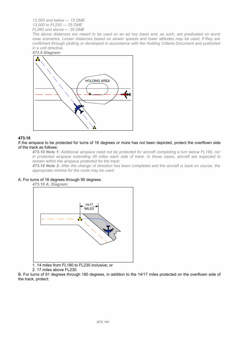
12,000 and below — 15 DME13,000 to FL250 — 25 DMEFL260 and above — 35 DMEThe above distances are meant to be used on an ad hoc basis and, as such, are predicated on worst case scenarios. Lesser distances based on slower speeds and lower altitudes may be used, if they are confirmed through plotting or developed in accordance with the Holding Criteria Document and published in a unit directive.473.9 Diagram:
473.10If the airspace to be protected for turns of 16 degrees or more has not been depicted, protect the overflown side of the track as follows:
473.10 Note 1: Additional airspace need not be protected for aircraft completing a turn below FL180, nor in protected airspace extending 45 miles each side of track. In these cases, aircraft are expected to remain within the airspace protected for the track.473.10 Note 2: After the change of direction has been completed and the aircraft is back on course, the appropriate minima for the route may be used.
A. For turns of 16 degrees through 90 degrees:473.10 A. Diagram:
1. 14 miles from FL180 to FL230 inclusive; or2. 17 miles above FL230.
B. For turns of 91 degrees through 180 degrees, in addition to the 14/17 miles protected on the overflown side of the track, protect:
ATC 141

473.10 B. Diagram:
1. 28 miles from FL180 to FL230 inclusive on the manoeuvring side of the track; or2. 34 miles above FL230 on the manoeuvring side of the track.
473.11DME Lateral Separation:You may apply one of the following DME or lateral separation minima:A. between aircraft maintaining specified arcs of the same DME facility:
1. 20 miles; or 473.11 A. 1. Diagram:
14/172. 10 miles — provided both aircraft are 35 miles or less from the DME facility.
473.11 A. 2. Diagram:
B. between an aircraft that is maintaining a specified arc of a DME facility and the outeredge of protected airspace for other aircraft:
1. 10 miles; or ATC 142

473.11 B. 1. Diagram:
2. 5 miles — provided the aircraft maintaining the specified arc is 35 miles or less from the DME facility. 473.11 B. 2. Diagram:
473.12OMNI-Track Separation.You may apply one of the following separation minima provided you establish aircraft on different specified radials of the same OMNI facility.
473.12 Note 1: The terms “inbound” and “outbound” are used in relation to the facility. Same direction aircraft are aircraft whose direction differs by less than 90 degrees. Opposite direction aircraft are aircraft whose direction differs by 90 degrees or more.473.12 Note 2: Where OMNI and DME facilities are collocated, you may use DME as follows, to satisfy the 15 miles requirement:
A. 30 degrees between: 473.12 A. Diagram:
ATC 143

1. Same direction, departing, outbound aircraft that are 15 miles or less from the facility.2. Same direction, en route, outbound aircraft that are 15 miles or less from the facility, provided the aircraft are 3 minutes or more from the facility.
B. 15 degrees between:1. Same direction, outbound aircraft provided at least one aircraft is more than 15 miles from the facility.
473.12 B. 1. Diagram:
2. Same direction, inbound aircraft provided the second aircraft is more than 15 miles, and 10 minutes or more, from the facility.
473.12 B. 2. Diagram:
3. Opposite direction aircraft provided: a. they will pass at a point more than 15 miles from the facility; or
473.12 B. 3. a. Diagram:
b. the outbound aircraft is more than 15 miles from the facility.
ATC 144

473.13You may separate aircraft operating in the same or opposite direction by requiring operation on opposite sides of a track that can be accurately determined, provided an emergency condition necessitates this action
473.14For aircraft operating on the same or reciprocal tracks:A. maintain vertical separation until an aircraft diverging from an area of overlap, at an angle less than 45 degrees, is separated from the area of overlap by the greater of:
1. 5 minutes; or2. half the longitudinal separation minimum applicable; or
B. establish vertical separation before an aircraft converging to an area of overlap, at an angle of less than 45 degrees, reaches a point that is separated from the area of overlap by the greater of:
1. 5 minutes; or2. half the longitudinal separation minimum applicable.
474 LONGITUDINAL SEPARATION
474.1Separate aircraft longitudinally by a minimum distance expressed in units of time or in miles.
474.2Apply longitudinal separation expressed in units of time so that after one aircraft passes over a specific position a succeeding aircraft at the same altitude will not, on the basis of a control estimate, arrive over the same position within less than the minimum number of minutes specified by the appropriate separation minimum. (D)
474.2 Diagram:
474.3Establish longitudinal separation by clearing an aircraft:A. to depart at a specified time;B. to arrive over a specified fix at a specified time;
474.3 B. Phraseology:ARRANGE YOUR FLIGHT TO ARRIVE OVER (reporting point) NOT BEFORE/LATER THAN (time).
C. to hold at a fix until a specified time; orD. to reverse heading.
474.4Establish longitudinal separation on the basis of position reports only if:A. both aircraft have reported over the same reporting point; orB. the following aircraft has confirmed not yet reaching the reporting point used by the leading aircraft.
474.5Initially establish longitudinal separation, expressed in miles, on the basis of position reports from the concerned aircraft determined in relation to a common point.
474.5 Note 1: You may continue to provide longitudinal separation based on position reports in relation to adjacent DME facilities, provided both aircraft are en route between the same two facilities and the lead aircraft has changed over to the next facility along the route.
ATC 145

474.5 Note 2: Common point may be the same DME NAVAID, the same GPS reference position or a collocated DME NAVAID/GPS reference position.474.5 Note 3: GPS receivers typically display distance information in relation to the next waypoint. Pilots can provide distance information to other fixes upon request. When using GPS position reports to establish longitudinal separation, controllers must ensure that the distance reports are in relation to a common point.474.5 Note 4: Position reports based on RNAV and GPS will be provided in miles (e.g. 30 miles from Sumspot VOR). When position reports are based on DME, pilots will state DME (e.g. 30 DME from Sumspot VOR).
474.6Apply longitudinal separation expressed in miles by:A. maintaining DCPC except when using DME and/or GPS to establish vertical separation; and B. requesting DME and/or GPS position reports, as necessary, to ensure the required separation is being maintained or increased.
474.7To establish longitudinal separation between aircraft providing a mix of DME and GPS position reports, the DME aircraft must be either 10,000 feet or below or outside of 10 miles from the DME NAVAID, to account for DME slant range.
474.7 Note: Once longitudinal separation is established, there is no requirement to impose another form of separation, while the DME aircraft transits the DME NAVAID within 10 miles, above 10,000 feet.
474.8You may request aircraft to maintain a specified longitudinal separation provided the aircraft are:
474.8 Phraseology:MAINTAIN AT LEAST (number) MILES/MINUTES SEPARATION FROM (aircraft identification).
A. in direct communication with each other; andB. using NAVAIDs that permit determination of position and speed at intervals not exceeding 40 minutes flying time.
474.9Separate aircraft on the same track by using one of the following minima:A. 15 minutes. B. 10 minutes provided NAVAID coverage permits determination of position and speed at intervals not exceeding 40 minutes flying time.
474.9 B. Note 1: The phrase “NAVAID coverage permits determination of position and speed” means that ATC must obtain a position report at least once every 40 minutes to continue to apply longitudinal minimum of 10 minutes or less.474.9 B. Note 2: In addition to the actual NAVAID fixes used for position reports, radials from VHF NAVAIDs, DME arcs, bearings from a NDB, waypoints from RNAV and full degrees of longitude or latitude from GPS equipped aircraft may also be used. If any of the above are used, the fix positions must be such that when considering the speed of the aircraft, the estimates and subsequent position reports between reporting fixes are no more than 40 minutes flying time apart.474.9 B. Diagram:
C. 5 minutes between:1. aircraft that have departed from adjacent locations and have reported over the same reporting point;2. en route aircraft that have reported over the same reporting point; or
ATC 146

3. a departed aircraft behind an en route aircraft that has reported over the reporting point serving the point of departure; 474.9 B. Notes 1 and 2 apply to this paragraph. provided that, in each case, the leading aircraft is maintaining a speed that is 20 knots or more faster than the following aircraft and NAVAID coverage permits determination of position and speed at intervals not exceeding 40 minutes flying time.
D. 3 minutes between: 474.9 D. Diagram:
1. aircraft that have departed from adjacent locations and have reported over the same reporting point;2. en route aircraft that have reported over the same reporting point; or3. a departed aircraft behind an en route aircraft that has reported over the reporting point serving the point of departure;
474.9 B. Notes 1 and 2 apply to this paragraph. provided that, in each case, the leading aircraft is maintaining a speed that is 40 knots or more faster than the following aircraft and NAVAID coverage permits determination of position and speed at intervals not exceeding 40 minutes flying time.
474.10Separate aircraft on the same track using DME and/or GPS by one of the following minima:A. 20 miles.B. 10 miles between:
474.10 B. Diagram:
1. aircraft that have departed from adjacentlocations and have reported over the same reporting point;2. en route aircraft that have reported DME and/or LTD in relation to a common point; or
474.10 B. 2. Note: LTD is the Along Track Distance derived from a GPS receiver, typically in relation to the next waypoint.
3. a departed aircraft behind an en route aircraft that has reported over the reporting point serving the point of departure; provided that, in each case, the leading aircraft is maintaining a speed that is 20 knots or more faster than the following aircraft.
C. 5 miles between:
ATC 147

474.10 C. Diagram:
1. aircraft that have departed from adjacent locations and have reported over the same reporting point;2. en route aircraft that have reported DME and/or LTD in relation to a common point; or
474.10 C. 2. Note: 474.10 B. 2. Note applies here.3. a departed aircraft behind an en route aircraft that has reported over the reporting point serving the point of departure; provided that, in each case, the leading aircraft is maintaining a speed that is 40 knots or more faster than the following aircraft.
474.11Separate aircraft on the same track, at the time altitude levels are crossed, by using one of the following minima:A. minimum specified in 474.9 or 474.10.B. 5 minutes provided:
474.11 B. Diagram 1:
474.11 B. Diagram 2:
1. the altitude change is commenced not later than 10 minutes after the following aircraft has reported over the reporting point used by the leading aircraft;
ATC 148

2. the leading aircraft is descending through the altitude of the following aircraft or the following aircraft is climbing through the altitude of the leading aircraft; and3. the vertical separation at the time of commencement of change is 4,000 feet or less.
C. 10 miles provided:1. both aircraft are using DME and/or GPS; and2. the leading aircraft is descending through the altitude of the following aircraft or the following aircraft is climbing through the altitude of the leading aircraft.
D. When you are unable to establish DCPC, 10 miles provided: 1. both aircraft are using the same DME and/or LTD from a common point;
474.11 D. 1. Note: 474.10 B. 2. Note applies here.2. the leading aircraft is 20 knots or more faster than the following aircraft;3. the leading aircraft is descending through the altitude of the following aircraft or the following aircraft is climbing through the altitude of the leading aircraft;4. the vertical separation at the commencement of change is 4,000 feet or less; and5. the position of the lead aircraft is determined before that of the following aircraft.
474.12Separate aircraft on crossing tracks by using one of the following minima: A. 15 minutesB. 10 minutes provided NAVAID coverage permits determination of position and speed at intervals not exceeding 40 minutes flying time.
474.9 B. Notes 1 and 2 apply to this paragraph.474.12 B. Diagram:
C. 20 miles provided both aircraft are using DME and/or LTD from a common point and the tracks cross at the common point.
474.12 C. Diagram:
D. 10 miles provided both aircraft are using DME and/or LTD from a common point and the tracks cross at the common point, and the leading aircraft is maintaining a speed that is 20 knots or more faster than the following aircraft.
ATC 149

475 INITIAL SEPARATION
475.1You may apply one of the separation minima contained in this subsection until another separation minimum is established provided:A. if aircraft depart from the same runway, the leading aircraft is not authorized to turn in either direction, to atrack that is more than 135 degrees from the extended runway centreline; or
475.1 A. Note: The use of the word track throughout subsection 475 is to be used synonymously with heading, bearing, radial, ILS course, etc. Provided the divergence is 45 degrees or more, you may apply a heading to one aircraft and a track to the other. Below that value, do not intermingle headings and precisely defined tracks for initial separation application; that is, do not assign a heading to one aircraft and a track to the other.
B. if aircraft depart from different runways, the leading aircraft is not authorized to turn:1. toward the extended centreline of the runway to be used by the following aircraft; and2. in the other direction to a track that is more than 135 degrees from the extended centreline of the runway to be used by the following aircraft.
475.2You may separate a departing aircraft from other departing aircraft by using one of the following minima:A. 5 minutes until altitude levels are crossed provided:
475.2 A. Diagram:
1. the following aircraft will climb through the altitude of the leading aircraft; and2. both aircraft follow the same track until vertical separation is established.
B. 5 minutes provided: 475.2 B. Diagram:
1. the leading aircraft will maintain a speed that is 20 knots or more faster than the following aircraft; and2. NAVAID coverage permits determination of position and speed at intervals not exceeding 40 minutes flying time474.9 B. Notes 1 and 2 apply to this paragraph.
C. 3 minutes provided: 1. the leading aircraft will maintain a speed that is 40 knots or more faster than the following aircraft; and
ATC 150
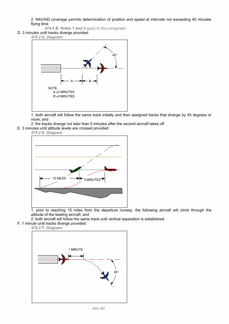
2. NAVAID coverage permits determination of position and speed at intervals not exceeding 40 minutes flying time
474.9 B. Notes 1 and 2 apply to this paragraph.D. 3 minutes until tracks diverge provided:
475.2 D. Diagram:
1. both aircraft will follow the same track initially and then assigned tracks that diverge by 45 degrees or more; and2. the tracks diverge not later than 5 minutes after the second aircraft takes off.
E. 3 minutes until altitude levels are crossed provided: 475.2 E. Diagram:
1. prior to reaching 15 miles from the departure runway, the following aircraft will climb through the altitude of the leading aircraft; and2. both aircraft will follow the same track until vertical separation is established.
F. 1 minute until tracks diverge provided:475.2 F. Diagram:
ATC 151
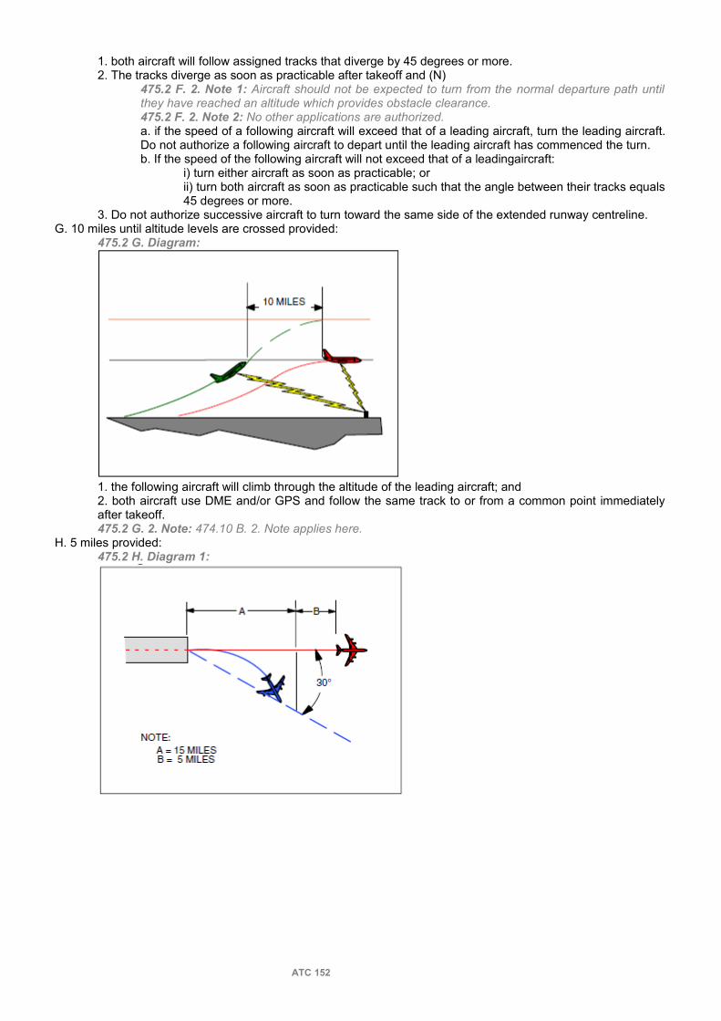
1. both aircraft will follow assigned tracks that diverge by 45 degrees or more.2. The tracks diverge as soon as practicable after takeoff and (N)
475.2 F. 2. Note 1: Aircraft should not be expected to turn from the normal departure path until they have reached an altitude which provides obstacle clearance.475.2 F. 2. Note 2: No other applications are authorized.a. if the speed of a following aircraft will exceed that of a leading aircraft, turn the leading aircraft. Do not authorize a following aircraft to depart until the leading aircraft has commenced the turn.b. If the speed of the following aircraft will not exceed that of a leadingaircraft:
i) turn either aircraft as soon as practicable; orii) turn both aircraft as soon as practicable such that the angle between their tracks equals 45 degrees or more.
3. Do not authorize successive aircraft to turn toward the same side of the extended runway centreline.G. 10 miles until altitude levels are crossed provided:
475.2 G. Diagram:
1. the following aircraft will climb through the altitude of the leading aircraft; and2. both aircraft use DME and/or GPS and follow the same track to or from a common point immediately after takeoff.475.2 G. 2. Note: 474.10 B. 2. Note applies here.
H. 5 miles provided: 475.2 H. Diagram 1:
ATC 152

475.2 H. Diagram 2:
1. other separation will be established not later than the time the following aircraft reaches a point 15 miles from the departure runway; and2. both aircraft use DME and/or GPS and follow the same track to or from a common point immediately after take-off.
475.2 H. 2. Note: 474.10 B. 2. Note applies here.
475.3You may authorize simultaneous takeoffs from parallel runways provided:
475.3 Diagram:
A. the runways are 4,300 feet or more (centreline to centreline) apart;B. neither aircraft will turn towards the other runway;C. both aircraft will follow assigned tracks that diverge by 45 degrees or more immediately after takeoff; andD. traffic information is passed to both aircraft.
475.4You may authorize simultaneous takeoffs from non-intersecting runways provided:
ATC 153

475.4 Diagram:
A. the runways diverge by 30 degrees or more;B. neither aircraft will turn toward the other runway; andC. the aircraft will fly assigned tracks that diverge by 45 degrees or more immediately after takeoff.
475.5When aircraft are departing from intersecting runways, you may authorize a succeeding aircraft to take off provided:
475.5 Diagram:
A. the runways diverge by 30 degrees or more;B. the preceding aircraft has passed the point of runway intersection;C. neither aircraft will turn toward the other runway; andD. the aircraft will fly assigned tracks that diverge by 45 degrees or more immediately after takeoff.
475.6You may authorize takeoffs in any direction provided the airspace to be protected for the departure areas do not overlap.
475.7You may authorize a departing aircraft to take off, while an arriving aircraft is on an instrument approach to the same airport:A. in any direction, provided it will have a minimum of 5 minutes separation from an arriving aircraft on a straight-in approach, at the point where it will alter its heading to diverge from the reciprocal of the final approach track of the arriving aircraft by aminimum of:
1. 45 degrees; or
ATC 154

475.7 A. 1. Diagram:
2. 30 degrees, provided both the arriving and departing aircraft will use a facility located on the airport, that provides track guidance in the form of an OMNI radial or an ILS front or back beam; or
475.7 A. 2. Diagram:
B. in a direction that differs from the reciprocal of the final approach track of the arriving aircraft by a minimum of 45 degrees, except when an arriving aircraft will make a procedure turn, in which case the minimum is increased to 90 degrees on the procedure turn side of the final approach track, provided the departing aircraft is airborne:
1. before the arriving aircraft is estimated to be not less than 3 minutes from the instrument runway; or 475.7 B. 1. Note:A. The 90 degree minimum may be reduced to 45 degrees on the procedure turn side of the final approach track, where airspace planners have determined and documented that the protected airspace associated with the departure procedure does not overlap the airspace to be protected for the initial approach area.B. Apply this minimum only if:
1. the arriving aircraft is making a straight-in approach; or2. the fix from which the procedure turn is commenced is located between the procedure turn and approach end of the instrument runway.
C. Apply this minimum when an arriving aircraft executes a circling procedure, only if the procedure is authorized in accordance.D. Use controller computed estimates and obtain reports from the arriving aircraft as necessary, to ensure achievement of the 3 minute minimum.
ATC 155

475.7 B. 1. Diagram 1:
475.7 B. 1. Diagram 2:
2. before the arriving aircraft leaves a fix inbound not less than 4 miles from the instrument runway. 475.7 B. 2. Note:A. The 90 degree minimum may be reduced to 45 degrees on the procedure turn side of the final approach track, where airspace planners have determined and documented, that the protected airspace associated with the departure procedure does not overlap the airspace to be protected for the initial approach area.B. Apply this minimum only if an airport control service is being provided.C. Apply this minimum when an arriving aircraft executes a circling procedure, only if the procedure is authorized in accordance.D. Specify the fix at which the pilot is to report inbound.E. The fix can be based on LTD during a GPS approach.475.7 B. 2. Diagram 1:
ATC 156

475.7 B. 2. Diagram 2:
476 SEPARATION FROM CLASS F AIRSPACE
476.1Apply the appropriate separation minimum between an aircraft and the outer edge of Class F airspace, except if: A. the aircraft states that it has obtained permission from the division to enter the area; (N)
476.1 A. Note: Aircraft are prohibited from entering an active restricted area unless permission is granted by the division or the area is released to the controlling user by the division.
B. the aircraft is operating on an ALTRV APVL; orC. the aircraft has been cleared for a contact or visual approach.
476.2If an aircraft requests a clearance to penetrate an advisory area or fly closer to it than separation minima would permit without permission from the Division advise the aircraft that you are unable to provide an IFR clearance. If the aircraft insists on penetrating the advisory area or fly closer to it than separation minima would permit, issue an advisory.
476.2 Phraseology:ADVISORY AREA (name/number) IS ACTIVE. AN ATC CLEARANCE CANNOT BE ISSUED. YOU ARE PROCEEDING THROUGH ADVISORY AREA AT YOUR OWN RISK.
476.3Apply 500 feet vertical separation from an active Class F advisory airspace, unless wake turbulence minima is required, in which case apply 1,000 feet vertical separation.
476.3.Note The 500 feet separation may differ from division to division. See local procedures.
477 SEPARATION FROM AIRSPACE RESTRICTED BY THE LOCAL DIVISION
477.1Apply vertical, lateral or geographical separation between an aircraft and the following:A. an area in the vicinity of a simulated forest fire as defined by NOTAM or other means such as forum or SO events; and
477.1 A. Note: The Division may issue a NOTAM or an announcement in the local forum, restricting operations in the vicinity of a simulated forest fire.
B. areas restricted to ensure aviation safety.
478 SEPARATION FROM PHOTOGRAPHIC SURVEY AIRCRAFT
478.1Protect airspace in the following dimensions for photographic survey aircraft that are operating on specific flights in accordance with CVFR or IFR:
478.1 Note 1: Coverage permitting, radar separation may be provided between other aircraft and the photo survey aircraft or between other aircraft and the airspace to be protected for the photo survey aircraft.
ATC 157
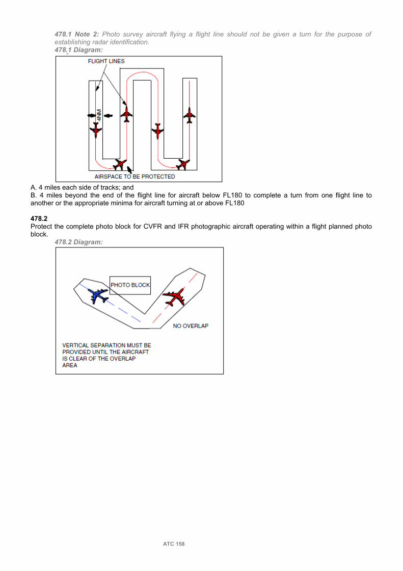
478.1 Note 2: Photo survey aircraft flying a flight line should not be given a turn for the purpose of establishing radar identification.478.1 Diagram:
A. 4 miles each side of tracks; andB. 4 miles beyond the end of the flight line for aircraft below FL180 to complete a turn from one flight line to another or the appropriate minima for aircraft turning at or above FL180
478.2Protect the complete photo block for CVFR and IFR photographic aircraft operating within a flight planned photo block.
478.2 Diagram:
ATC 158

480 RNPC
481 RNPC GENERAL
481.1Apply the criteria and procedures in this section to RNPC certified aircraft and to aircraft with an equipment suffix /G operating within RNPC airspace, unless otherwise indicated.
481.1 Note: Certification to operate in accordance with RNPC will be indicated by the appropriate suffix on domestic flight plans. Aircraft indicating certification to operate in NAT MNPS airspace are considered certified for RNPC airspace. Foreign carriers overflying may be considered certified, on the basis that they have flight planned into the airspace and their route of flight indicates the use of RNAV equipment. If for any reason (aircraft type, route, track keeping etc.) you suspect an aircraft may not be certified, you should query the pilot and, depending upon the response, take appropriate action.
481.2You may clear an aircraft “via RNAV direct” to indicate the method of navigation expected to be used. (P)
481.2 Phraseology:VIA RNAV DIRECT.
482 RNPC VERTICAL SEPARATION
482.1You may discontinue vertical separation between RNPC certified aircraft on reciprocal tracks, provided RNAV positions indicate they have passed and are 30 miles apart.
483 RNPC LATERAL SEPARATION
483.1For RNPC certified aircraft protect:
483.1 Diagram:
A. 10 miles each side of track, if operating off airways; orB. the airspace to be protected for an airway, if operating on airways.
484 RNPC LONGITUDINAL SEPARATION
484.1Apply longitudinal separation, expressed in miles, by:A. maintaining DCPC; andB. requesting position reports determined through RNAV, as necessary, to ensure required separation is maintained or increased; orC. use of radar.
ATC 159

484.2Advise RNPC certified aircraft to use DME distance if applying DME separation.
484.2 Phraseology:USE DME DISTANCES.
484.3Separate RNPC certified aircraft operating on the same track, or crossing tracks, by a minimum of 10 minutes. (N)
484.3 Note: Aircraft using RNAV have the capability to establish positions at any point along track.
484.4Separate RNPC certified aircraft operating on the same track by 30 miles, provided distance is determined through RNAV from a common point.
484.4 Diagram:
484.5You may separate RNPC certified aircraft that are transitioning from a radar to a non radar environment, but have not reported over a common point, by 30 miles provided you ensure through the use of radar or RNAV distance that the minimum will exist at the common point from which the aircraft will follow the same track or continuously diverging tracks.
484.5 Note: As necessary, request position reports from common points to ensure the required separation is being maintained or increased.
484.6Separate RNPC certified aircraft on crossing tracks by 30 miles, as determined by RNAV distance from the crossing point.
484.7If aircraft are on crossing tracks or converging to or diverging from an area of overlap at an angle of less than 45 degrees, establish vertical separation before the RNPC certified aircraft reaches a point 15 miles, as determined by RNAV, from the area of overlap.
484.7 Note 1: The other aircraft need not be RNPC certified.484.7 Note 2: DCPC is not required in this case.484.7 Note 3: If an RNAV position along the track of the approaching aircraft can be used as the point to effect the restriction, it must be at least 15 miles from the area of overlap. Since the pilot has continuous readout of distance to go, there is reasonable assurance that the restriction will be achieved without holding.484.7 Note 4: You may use the following table to determine the distance from various protected airspaces, at whichvertical separation must be established, as measured from where the tracks cross.
ATC 160

484.7 Note 5: In lieu of specifying a RNAV distance, vertical separation may be established or discontinued, where the aircraft crosses the nearest full or half degree of latitude or longitude that will provide the required separation. 484.7 Diagram:
485 RNPC LONGITUDINAL SEPARATION — MACH-NUMBER TECHNIQUE
485.1Apply longitudinal separation minima using Mach-number technique, to RNPC certified aircraft operating within or proceeding to or from RNPC airspace.
485.2Assign the appropriate Mach-number, for the duration of the application, whenever Machnumber is being used for separation.
485.2 Note: When reclearing aircraft on entry into RNPC airspace from oceanic airspace, and separation is based on Mach-number technique, it is necessary that the Mach-number form part of the clearance.
485.3Ensure that the required separation is being maintained or increased while applying Machnumber technique by obtaining, as necessary, confirmation from the pilot that the assigned Mach-number is being maintained.
485.3 Phraseology:CONFIRM MAINTAINING MACH (number).485.3 Note: Requests for confirmation of Mach-number may be done in conjunction with a position report.
ATC 161

485.4Separate RNPC certified aircraft by 10 minutes provided:
485.4 Diagram:
A. Mach-number technique is used; B. aircraft are in level flight, climbing, or descending;C. aircraft are operating on the same track or continuously diverging tracks;D. aircraft have reported over a common point; and (R)E. the required longitudinal separation will be maintained until tracks diverge; and, when tracks diverge, the required lateral separation, and at least 5 minutes longitudinal separation, will exist at the next significant point.
485.4 E. Diagram:
485.5You may separate aircraft that have not reported over a common point, as specified in 485.4 D., provided you ensure through the use of radar, DME, or RNAV distance, that the minimum will exist at the common point from which the aircraft will follow the same track or continuously diverging tracks.
485.5 Diagram:
ATC 162

485.6You may reduce the minimum specified in 485.4 in accordance with the following table, provided:
485.6 Note: The 5 minute longitudinal separation minimum is no longer required, if the aircraft are following continuously diverging tracks and the required lateral separation will be achieved at the next significant point.
A. the preceding aircraft is maintaining a greater Mach-number than the succeeding aircraft; andB. 1. the aircraft reported over a common point; or
485.6 B. 1. Note: The fix tolerance area for the fix derived from ground based NAVAIDs shall not exceed that of an NDB at the appropriate altitude.
2. radar, DME, or any RNAV distance is used to ensure that the appropriate time interval exists and will exist at the common point.
485.7Separate a faster succeeding aircraft from a preceding aircraft, by ensuring that not less than 10 minutes longitudinal separation is maintained:
485.7 Note 1: Determine the extra time required by following the column of the slower aircraft groundspeed until it intercepts the difference in Mach column. Multiply this time by the number of hours the faster aircraft will fly from the point of application to the point of destination/divergence/other separation, to determine the additional longitudinal separation necessary.485.7 Note 2: Where automated systems provide conflict prediction, there is no requirement to use the table to determine the appropriate separation minimum.485.7 Note 3: Groundspeed based on RNAV systems, or radar displayed information, is acceptable.
ATC 163

A. until tracks diverge, provided the required lateral separation and at least 5 minutes longitudinal separation will exist at the next significant point; orB. to a point at which another form of separation will be achieved.
486 RNPC PARALLEL OFFSET PROCEDURES - NON-RADAR ENVIRONMENT
486.1In a non-radar environment, you may use parallel offset techniques provided:
486.1 Note 1: Parallel offset is a feature of some RNAV systems and enables the aircraft to fly offset from a specific route by a specific number of miles.486.1 Note 2: Aircraft will normally not diverge to the offset track by more than 45 degrees. Some RNAV systems are limited in the offset distance.
A. aircraft are operating within RNPC High Level Controlled Airspace;B. the procedure is used to accomplish an altitude change;C. aircraft are operating on same direction tracks;D. the aircraft to be offset;
1. is RNPC certified; and 2. confirms the capability to offset.
486.1 D. 2. Phraseology:ADVISE IF ABLE TO PROCEED PARALLEL OFFSET.
E. the minimum offset value ensures at least 10 miles separation from the edge of the protected airspace of the other aircraft;
486.1 E. Note: The other aircraft is not required to be RNPC certified.486.1 E. Diagram:
ATC 164

F. vertical separation is maintained until the offset aircraft reports established on the parallel offset track. (P)486.1 F. Phraseology:PROCEED OFFSET (number) MILES (right/left) OF CENTRELINE (track/route) REPORT ESTABLISHED ON PARALLEL OFFSET.— or —PROCEED OFFSET (number) MILES (right/left) OF CENTRELINE (track/route), AT (significant point/ time) UNTIL (significant point/time) REPORT ESTABLISHED ON PARALLEL OFFSET.
486.2When the offset aircraft reports established on the parallel offset track, you may issue a clearance for an altitude change to either aircraft.
486.3Request reports to determine the reestablishment of vertical separation.
486.4Unless required for further control purposes, once vertical separation is re-established, cancel the parallel offset, or clear the offset aircraft to a downstream waypoint or fix on its route of flight.
ATC 165

490 COORDINATION
491 FLIGHT DATA TRANSFER
491.1If passing data on an IFR or CVFR flight, obtain a readback for:
491.1 Note: Data on an IFR flight includes estimates, position reports, and revisions.A. aircraft identification; andB. the following if passed:
1. estimate or actual time for the fix; and2. altitude information.
491.2If receiving data on an IFR or CVFR flight, read back: A. aircraft identification; andB. the following if received:
1. estimate or actual time for the fix; and491.2 B. 1. Note: The receiving controller may omit reading back the estimate if a radar hand-off will follow between the sectors or units concerned.
2. altitude information.
492 IFR UNIT — IFR UNIT
492.1Coordinate a clearance before transmission to an aircraft, if it will become effective within another unit's area of responsibility.
492.2The receiving controller shall, if necessary, inform the transferring controller of:A. the pertinent details to be included in the combined clearance; andB. the time period during which the clearance may be issued.
492.3Forward the following flight data and control information 15 minutes or more before an IFR or CVFR aircraft is estimated to enter an adjacent IFR unit's area:
492.3 Note: This time requirement may be increased or decreased by an agreement.A. Aircraft identification.B. Type of aircraft:
1. prefixed by the number of aircraft if more than one; and2. the appropriate equipment suffix.
C. Speed:1. filed true airspeed in knots;2. Mach-number; or3. actual ground speed.
D. SSR code assignment, if necessary.E. Point of departure, remaining portion of the route of flight as specified in the original or amended clearance, and destination.F. Estimated time and altitude over the last fix within the control area or other point agreed to by the concerned units.G. Altitude of entry into the adjacent unit's area if different from the altitude over the last fix.H. Estimated time of arrival as specified in the flight plan if requested.I. Clearance information, such as:1. clearance limit if other than the destination airport; or2. special instructions if issued.J. The fact that an aircraft is a diversion, if this is the case.K. Altitude requested if different from the assigned altitude.L. Other information if appropriate.
492.3 L. Note: Other information may include a declaration of minimum fuel or an emergency.
ATC 166

492.4Where units are connected by ivac, specified in 492.3 B., C., D., and E., does not require confirmation by controllers passing and receiving estimates. If amendments to this data have been made and are not included in the original flight plan message, controller confirmation is required.
492.5NOT APPLICABLE
492.6INTENTIONALLY BLANK
492.7Forward the position report over the last fix within the control area if:A. the report indicates that only minimum separation exists at that point; orB. the report differs from the previously passed estimate by 3 minutes or more.
492.8Specify the separation minimum being applied if less than 10 minutes longitudinal separation will exist between aircraft entering a receiving unit's area.
493 IFR UNIT — TOWER AND FLIGHT SERVICE STATION
493.1Forward to towers or FSSs, the following data concerning arriving IFR or CVFR aircraft 15 minutes or more before the aircraft will establish communication with the tower or FSS:
493.1 Note: This time requirement may be increased or decreased by an inter-unit arrangement.A. Aircraft identification.B. Type of aircraft, prefixed by the number of aircraft if more than one.C. Point of departure.D. An estimate over an adjacent en route navigation facility or over the navigation facility serving the approach procedure to be used.
493.1 D. Note: Clearly state the name of the navigation facility to which the estimate applies.E. Other information, including the fact that an aircraft is a diversion.
493.2Forward to towers or FSSs:A. revised information because of changes to data previously passed; andB. a revised control estimate if it differs from the previously passed estimate by 3 minutes or more.
493.3Forward to towers or FSSs, the position report over the approach aid if it differs from the previously passed estimate by 3 minutes or more, unless you are aware that the tower or FSS has the report.
493.4Forward to towers or FSSs, the following data concerning departing IFR or CVFR aircraft as soon as practicable:A. Flight plan data if other than scheduled.B. Anticipated delay to a departing aircraft.
493.5Forward to towers or FSSs, pertinent data concerning over-flying IFR or CVFR aircraft that will penetrate a control zone.
493.6Inform the tower or FSS of any condition that necessitates revision of an ATIS message.
494 COMMUNICATION TRANSFER
494.1Transfer radio communications immediately prior to an aircraft entering the receiving controller's area of responsibility unless otherwise coordinated.
ATC 167

494.1 Note: Coordination procedures for radio communication transfer may be outlined in unit directives or agreements.
494.2When a change of frequency is required, instruct the aircraft to contact or monitor:
494.2 Phraseology:CONTACT/MONITOR (unit/function/agency) ON (frequency) NOW/AT (time)/AT/OVER (location/fix).
A. a specified unit/function/agency; B. on a specified frequency;C. 1. now;
2. at a specified time; or3. over a specified fix.
494.3Specify both primary and secondary high frequencies (HF) if transferring an aircraft to HF
494.4If possible resolve all traffic conflictions for an IFR aircraft approaching an uncontrolled aerodrome except as specified in 494.7. (N)
494.4 Note 1: An uncontrolled aerodrome is an aerodrome without a Control Tower in operation.494.4 Note 2: Mandatory Frequencies, where designated, will be published in the AIP. However UNICOM 122.800MHz is the designated frequency worldwide for any uncontrolled airspace.
494.5Instruct an aircraft, approaching a Mandatory Frequency Area, to make all required reports on the Mandatory Frequency.
494.5 Phraseology:(Aircraft ident) ADVISE PRIOR TO LEAVING THIS FREQUENCY TO MAKE THE MANDATORY FREQUENCY REPORTS.(Aircraft ident) ADVISE RETURNING TO THIS FREQUENCY.
494.6Instruct an aircraft to change to the Mandatory Frequency before it reaches the Mandatory Frequency specified area.
494.7If you require the aircraft on your frequency when it is in the Mandatory Frequency Area:A. confirm that the pilot is capable of maintaining a listening watch on the Mandatory Frequency while remaining on the ATC frequency;B. advise the communications agency having the Mandatory Frequency that you will retain the aircraft on your frequency, give an estimated position of the aircraft, the pilot's intentions and request traffic information; orC. if there is no direct line to the agency having the Mandatory Frequency, advise the pilot to make a report of the aircraft position and intentions on the Mandatory Frequency, monitor the MF and return to your frequency.
494.8If an aircraft is unable to maintain a listening watch on the Mandatory Frequency while remaining on the ATC frequency, resolve all conflicts with the aircraft and change the aircraft to the Mandatory Frequency prior to the specified Mandatory Frequency Area.
494.9Instruct, in the initial clearance, departing IFR aircraft in a Mandatory Frequency Area to contact the appropriate ATC frequency at the Mandatory Frequency Area boundary, or sooner when required, only if the aircraft is capable of maintaining a listening watch on the Mandatory Frequency.
494.10Specify a DCPC frequency if the aircraft is, or will be, within communication range. Otherwise, specify the frequency of an appropriate communication agency.
494.10 Note: Communication range depends on both altitude and distance.
495 CONTROL TRANSFER
495.1The responsibility for control of a departing IFR or CVFR aircraft is automatically transferred from the tower to the IFR unit as soon as the aircraft is airborne unless otherwise coordinated.
ATC 168

495.2The responsibility for control of an arriving IFR or CVFR aircraft is automatically transferred from the IFR unit to the tower as soon as the aircraft has landed unless otherwise coordinated.
495.2 Note 1: Except in Class A airspace, an aircraft may cancel IFR and proceed CVFR or VFR. Control transfer is effected as specified in inter-unit arrangements.495.2 Note 2: This paragraph does not apply when tower is also IFR unit itself. (Most of the cases)
495.3You may approve a tower's request for control of an arriving IFR or CVFR aircraft provided the aircraft:
495.3 Note: Control transfer cannot be effected if the aircraft conducting the approach has indicated no intention of landing upon completion of the approach and will continue to operate on an IFR clearance, i.e. the aircraft will execute a missed approach, perform another instrument approach or proceed to another location.
A. has been cleared for an approach; orB. will have been cleared for an approach when it reaches the point agreed upon by you and the airport controller.
495.4If you are able to approve a tower's request for control of an arriving IFR or CVFR aircraft, respond in the following form:A. (Aircraft identification).B. YOUR CONTROL.C. NOW/AT (specific point).D. (Conditions applicable to control transfer if necessary).E. (Information regarding the next IFR or CVFR arrival if necessary).
495.5If you are unable to approve a tower's request for control of an arriving IFR or CVFR aircraft, respond in the following form:A. (Aircraft identification).B. UNABLE.C. (The reason for refusal if workload permits).
496 AIRCRAFT DIVERSIONS
496.1Forward information regarding diverting aircraft to adjacent sectors/units as soon as possible after being made aware of it.
496.1 Note: Since a diversion may be expected to affect fuel reserves, timely coordination is beneficial and required.
ATC 169

PART 5 — RADAR PROCEDURES500 _ GENERAL
501 PROVISION OF SERVICE502 DISPLAY PRESENTATION503 ALTITUDE READOUTS504 ALTITUDE FILTERS505 POSITION REPORTS — RADAR IDENTIFIED AIRCRAFT506 PARALLEL OFFSET PROCEDURES507 SAFETY ALERT508 DEVIATION FROM ASSIGNED AIRSPACE
510 _ IDENTIFICATION
511 RADAR IDENTIFICATION512 HAND-OFF — TRANSFERRING CONTROLLER513 HAND-OFF — RECEIVING CONTROLLER514 POINT-OUT — ORIGINATING CONTROLLER515 POINT-OUT — RECEIVING CONTROLLER
520 _ SECONDARY SURVEILLANCE RADAR (SSR)
521 TRANSPONDER OPERATION522 OPERATION WITHOUT A TRANSPONDER IN TRANSPONDER DESIGNATED AIRSPACE523 SSR CODE ASSIGNMENT
530 _ SEPARATION
531 APPLICATION532 MINIMA533 WAKE TURBULENCE MINIMA534 CATEGORY II ILS APPROACHES535 CATEGORY III ILS APPROACHES
540 _ VECTORING
541 GENERAL542 APPLICATION OF VECTORS543 METHODS OF VECTORING544 SPEED ADJUSTMENT545 POSITION INFORMATION546 OBSTRUCTION CLEARANCE547 TERMINATION OF VECTORING
550 _ RADAR DEPARTURES
551 GENERAL552 DEPARTURE VERSUS ARRIVAL553 DEPARTURE VERSUS DEPARTURE554 SUCCESSIVE DEPARTURES
560 _ ARRIVALS
561 GENERAL562 SUCCESSIVE ARRIVALS563 APPROACH INFORMATION564 INTERCEPTION OF FINAL APPROACH565 MISSED APPROACHES566 VISUAL APPROACHES567 VISUAL APPROACHES TO MULTIPLE RUNWAYS568 PUBLISHED VISUAL APPROACH PROCEDURES569 RNAV STAR PROCEDURES
ATC 170

570 _ SIMULTANEOUS OPERATIONS
571 SIMULTANEOUS INDEPENDENT PARALLEL ILS APPROACHES572 SIMULTANEOUS DEPENDENT PARALLEL ILS APPROACHES573 SIMULTANEOUS ARRIVALS ARRIVAL/DEPARTURE
580 _ COORDINATION
581 RADAR — TOWER582 ARRIVAL — PRECISION APPROACH RADAR (PAR)583 CONTROL TRANSFER
ATC 171
PART 5 — RADAR PROCEDURES
500 GENERAL
501 PROVISION OF SERVICE
501.1Use a radar control procedure in preference to a non-radar control procedure.
501.2You may provide radar control service provided:A. the aircraft is radar identified;
501.2 A. Note: The requirement for radar identification does not apply to:A. an aircraft departing or executing a missed approach, as explained in 531.2; or ;B. an unidentified aircraft, while a radar-identified aircraft, or vice versa, is climbing or descending through its altitude, as explained in 531.3.
B. the aircraft is operating within controlled airspace, except as described in 542.1; C. you are satisfied that the displayed radar information is adequate; and D. you are in direct communication with the aircraft, except if:
1. an emergency situation dictates otherwise; or (N)501.2 D. 1. Note: In an emergency situation you may relay radar vectors through any communication link available; i.e. another aircraft, company radio, FSS.
2. the aircraft has been cleared for an approach; and3. you have transferred communication of the arriving aircraft to the tower.
501.2 D. 3. Note: The arrival controller is responsible to ensure separation is maintained until responsibility for control has been transferred to the tower.
501.3If you apply radar separation between two radar- identified aircraft, you are required to have direct communication with only one of the aircraft.
501.4Inform the aircraft when radar service is terminated.
501.4 Phraseology:RADAR SERVICE TERMINATED (non-radar routing if required).501.4 Note: Radar control service is automatically terminated and the aircraft need not be advised when the aircraft cancels IFR or is cleared for an approach.
501.5INTENTIONALLY BLANK
501.6Inform an aircraft immediately if radar service is terminated, due to equipment failure.
501.6 Phraseology:RADAR SERVICE TERMINATED DUE TO (reason).
501.7If service is degraded due to failure of a system component, inform the aircraft. (P)(N)(R)
501.7 Phraseology:SECONDARY RADAR OUT OF SERVICE. Sector controlling low-level airspace — PRIMARY RADAR OUT OF SERVICE. RADAR TRAFFIC INFORMATION NOT AVAILABLE ON AIRCRAFT WITHOUT TRANSPONDER.— or —RADAR WEATHER INFORMATION NOT AVAILABLE. Sector controlling high-level airspace only — RADAR WEATHER INFORMATION NOT AVAILABLE.
501.8In lieu of notifying individual aircraft, you may broadcast the notice of a degradation of service at intervals not exceeding 10 minutes.
501.9If SSR is the only source of radar information, you may use SSR as the sole radar source.
ATC 172

501.9 Note: PSR failure and radar coverage beyond PSR coverage are occasions when SSR is the only source of radar information.
502 DISPLAY PRESENTATION
502.1Display and monitor: 502.1 Note 1: In addition to the items listed, other features of the system may be used at the controller's discretion.502.2 Note 2: The information described here is general and should be interpreted based on the software being used, ivac or others.A. uncorrelated targets; B. CJSs;C. coast list;D. altitude readouts;.E. current weather data and history, as necessary, for the provision of severe weather information; F. VMI; andG. appropriate geographic map.
502.2NOT APPLICABLE
503 ALTITUDE READOUTS
503.1Validate altitude readouts by comparing the readout value with the altitude reported by the aircraft:
503.1 Phraseology:VERIFY YOUR ALTITUDE.503.1 Note 1: An altitude readout is valid, if the readout value does not differ from the aircraft-reported altitude by more than 200 feet.503.1 Note 2:
The aircraft does not have to be in level flight.A. on initial contact; orB. as soon as practicable, if the readout is not displayed, or cannot be validated on initial contact.
503.2If a readout is invalid, ensure that the aircraft has the correct altimeter setting and request another altitude verification.
503.2 Phraseology:YOUR ALTIMETER SETTING SHOULD BE (setting); VERIFY YOUR ALTITUDE.
503.3If the aircraft's altimeter setting is correct and the altitude readout remains invalid:A. Instruct the aircraft to reset its transponder; and B. If, after resetting, the readout remains invalid, instruct the aircraft to turn off its Mode C, and give the reason.
503.3 B. PhraseologySTOP SQUAWK MODE CHARLIE; ALTITUDE READOUT DIFFERS BY (number) FEET.
503.4If the aircraft's Mode C cannot be turned off without turning off the transponder, do not use the altitude readout as an indication of the aircraft's present altitude.
503.5If you observe a previously validated altitude readout to be invalid for four or more successive readout updates, take action in accordance with 503.2, 503.3 and 503.4 as appropriate.
503.6Inform the receiving sector or unit if any of the following conditions exist:A. Altitude readout not validated.
503.6 A. Phraseology:MODE CHARLIE NOT VALIDATED.
B. Automatic altitude reporting turned off.
ATC 173

503.6 B. Phraseology:MODE CHARLIE TURNED OFF.
C. Altitude readout invalid. 503.6 C. Phraseology:MODE CHARLIE IS INVALID.
503.7Provide the information specified in 503.6:A. before an automated hand-off;B. during an automated hand-off; orC. before transfer of control or transfer of communication, if a hand-off is not effected; andD. to the controller who is relieving you.
503.8You may use validated altitude readouts to determine aircraft altitudes as follows:A. Consider an aircraft to be maintaining an altitude, when its altitude readout value is within 200 feet of the assigned altitude.
503.8 A. Example:Consecutive readouts of 312, 310, 310, 308, 310 and 311 would indicate that an aircraft is maintaining FL310.
B. Consider an aircraft to have reached an altitude, when its altitude readout value has been within 200 feet of the assigned altitude for 4 consecutive readout updates.
503.8 B. Example:Consecutive readouts of 146, 144, 143, 142, 140, 141 and 141 would indicate that an aircraft has descended to and is maintaining 14, 000 feet ASL.
C. Consider an aircraft to have vacated an altitude, when its altitude readout value has changed by 300 feet or more, in the appropriate direction, from the value that prevailed while the aircraft was in level flight.
503.8 C. Note 1: The “starting point” is the aircraft's prevailing readout while in level flight, which may differ from the equivalent altitude figure. In 503.8 C. Example below, where the prevailing value during level flight was 139, the condition is met when the readout shows 136, not 137.503.8 C. Note 2: The VMI has both altitude and time VSPs. No VMI indication will be displayed for an aircraft whose rate of climb or descent falls outside the adapted VSPs for VMI.503.8 C. Example:Consecutive readouts of 139, 139, 139, 138, 137, and 136 would indicate that an aircraft has vacated 14,000 feet in descent.
D. Consider an aircraft to have passed an altitude, when its altitude readout value has changed by 300 feet or more in the appropriate direction.
503.8 D. Example:Consecutive readouts of 060, 062, 063 and 068 would indicate that a climbing aircraft has passed 6,500 feet ASL.
503.9Do not use invalidated altitude readouts to determine an aircraft's altitude. However, they may be used to:A. observe whether an aircraft is in level flight, climbing or descending;B. observe rates of climb or descent; or (N) 503.9 B. Note: If an aircraft climbs or descends at a very high rate, its readout values may fall behind the aircraft's actual altitude and the aircraft will coast.C. provide traffic information.
503.10Do not use altitude readouts of aircraft under the jurisdiction of another controller for determining aircraft altitudes unless:A. the other controller has confirmed the aircraft's altitude; orB. on hand-off the transferring controller does not inform you that an aircraft's altitude readout is invalid or not validated
503.11Do not use altitude readouts for aircraft when:A. the site altimeter setting for the geographic region concerned is below 26.00 or above 33.00 and the aircraft is operating below FL180;B. the site altimeter setting for the geographic region concerned is below 29.02 and the aircraft is operating at or above 17,000 ft and below FL180;C. the site altimeter setting for the geographic region concerned is below 28.02 and the aircraft is operating at or above 16,000 ft and below FL180; orD. the site altimeter setting for the geographic region concerned is below 27.02 and the aircraft is operating at or above 15,000 ft and below FL180.
ATC 174

504 ALTITUDE FILTERS
504.1 Select altitude filter limits that include as a minimum:A. the altitudes normally under the jurisdiction of your sector; andB. the first usable altitude in any vertically adjoining airspace under the jurisdiction of another controller, plus 200 feet beyond that altitude.
504.1 B. Example:A sector that has jurisdiction of the airspace from FL230 to FL350 would set its altitude filters at 218 and 372.
505 POSITION REPORTS — RADAR IDENTIFIED AIRCRAFT
505.1Do not request a radar-identified aircraft to make compulsory position reports unless you deem it necessary for control purposes.
505.2Instruct an aircraft to resume position reporting before terminating radar service.
505.2 Phraseology:RESUME POSITION REPORTS. RADAR SERVICE TERMINATED.
506 PARALLEL OFFSET PROCEDURES
506.1Use the parallel offset technique if an operational advantage is gained, provided;
506.1 Note 1: Parallel offset is a feature of some RNAV systems. This feature enables an aircraft to fly offset from a specific route by a specific number of miles. This permits controllers to apply radar separation without radar vectoring.506.1 Note 2: Aircraft will not normally diverge to the offset track by more than 45 degrees. Some RNAV systems are limited in the offset distance.
A. except as specified in 486.1, it is used only in a radar environment; B. the aircraft confirms the capability to offset; and
506.1 B. Phraseology:ADVISE IF ABLE TO PROCEED PARALLEL OFFSET.
C. the minimum offset value ensures the appropriate radar separation minimum will exist. 506.1 C. Phraseology:PROCEED OFFSET (number) MILES (right/left) OF CENTRELINE (track/route) AT (significant point/ time) UNTIL (significant point/time).
506.2Cancel the parallel offset if it is no longer required.
506.2 Phraseology:CANCEL OFFSET.
507 SAFETY ALERT
507.1Issue a safety alert to an aircraft if you are aware the aircraft is at an altitude which, in your judgment, places it in unsafe proximity to the terrain, an obstruction or another aircraft.
507.1 Phraseology:LOW ALTITUDE ALERT, VERIFY YOUR ALTITUDE IMMEDIATELY, ALTIMETER IS (setting).— or —THE MINIMUM IFR ALTITUDE IN YOUR AREA IS (altitude). ALTIMETER IS (setting).— or —TRAFFIC ALERT (position of traffic, if time permits), ADVISE YOU TURN RIGHT/LEFT (specific heading, if appropriate), or CLIMB/DESCEND (specific altitude, if appropriate) IMMEDIATELY.507.1 Note 1: Every situation where a safety alert should be passed may not be readily apparent; however, controllers should remain vigilant of such situations and issue safety alerts when such situations are recognized. Conditions such as workload, traffic volume, and the lead time to react, are all factors in determining whether it is reasonable for controllers to observe and recognize such situations.507.1 Note 2: You may be made aware of an unsafe proximity from; Mode C altitude readouts, observations by another sector or unit, or from pilot reports.
ATC 175

508 DEVIATION FROM ASSIGNED AIRSPACE
508.1Inform an aircraft if you observe that:A. it appears it will deviate, or it has deviated from its assigned route or holding area;B. the altitude readout indicates it has deviated by 300 feet or more from its assigned altitude, or
508.1 B. Phraseology:YOUR ALTITUDE READOUT IS (altitude), ALTIMETER IS (setting). VERIFY YOUR ALTITUDE.
C. the altitude readout indicates that it has deviated by 200 feet from its assigned altitude and the VMI indicates that the aircraft is continuing its climb or descent away from the assigned altitude.
508.1 C. Note 1: 508.1 B. Phraseology and 508.1 B. Reference apply here also.508.1 C. Note 2: An aircraft at a constant altitude and maintaining a previously assigned altimeter setting can appear to change altitude as it traverses system tiles.
508.2Assist the aircraft in returning to the assigned airspace if necessary.
ATC 176

510 IDENTIFICATION
511 RADAR IDENTIFICATION
511.1You may consider an aircraft identified, provided one of the following conditions is met:A. The aircraft is observed on radar to be in a position, within one mile of the end of the runway used for takeoff, that is consistent with the time of takeoff and the route of flight or assigned heading of a departing aircraft.B. The aircraft is observed on radar to be over a fix, which is indicated on the radar display, that is consistent with a position report received directly from the aircraft, provided the track is observed to be consistent with the route of flight or reported heading of the aircraft.
511.1 B. Note: A fix may be used as a reference for establishing aircraft identification, provided the position of the fix is accurately indicated on the radar display.
C. The aircraft is observed on radar to be in a position, relative to OMNI and DME NAVAIDs which are indicated on the radar display, that is consistent with a position report received directly from the aircraft in the form of a DME fix, provided that the track is observed to be consistent with the route of flight or reported heading of the aircraft.
511.1 C. Note: Caution should be exercised, if using a position report to identify an aircraft operating at high altitude, or reporting over an intersection which is a considerable distance from a NAVAID. Under these circumstances, aircraft often cannot accurately determine their precise position.
D. The aircraft is observed on radar to have carried out a specified identifying turn of at least 30 degrees, provided:
511.1 D. Note: A turn that would cause an aircraft to follow an airway or a frequently used flight path should be avoided. These circumstances could lead to missidentification of the aircraft.1. except in the case of a lost aircraft, a position report received directly from the aircraft indicates that the aircraft is within radar coverage of the area being displayed;2. only one aircraft is observed to have carried out the specified turn; and3. the track is observed to be consistent with the heading or track of the aircraft both before and after completion of the turn.
E. The appropriate change in the PPS is observed after the aircraft is instructed to operate the “Ident” feature of its transponder.
511.1 E. Phraseology:SQUAWK IDENT.SQUAWK (code) AND IDENT.
F. The appropriate change in the PPS is observed after the aircraft is instructed to change from one code to another.
511.1 F. Note: This change in PPS will occur only if the aircraft is asked to change to a code which will cause correlation to take place.
G. The PPS disappears or changes to a PSR symbol after the aircraft is instructed to change its transponder to “standby” and the PPS reappears or changes back to an SSR symbol after the aircraft is requested to return the transponder to normal operation.
511.1 G. Phraseology:SQUAWK STANDBY — SQUAWK (code).511.1 G. Note: Care should be taken to ensure that a period of time sufficient to ascertain that the loss of PPS resulted from the aircraft's action.
H. The position of the PPS on the tower display is consistent with the position of the aircraft observed visually by the airport controller.I. Identification was transferred by a hand-off.
511.2Use more than one of the procedures contained in 511.1, or use the same procedure more than once, if you have any doubt concerning the identity of a particular aircraft.
511.2 Note: Doubt may be caused by:A. the position or movement of other aircraft.B. the observation of more than one aircraft responding to an identification instruction; orC. other circumstances.
511.3If it appears that identification may become doubtful, take immediate action to ensure identification is maintained.
511.4If identification becomes doubtful or is lost, take immediate action to:
511.4 Note: Identification may be doubtful because of:
ATC 177

A. momentary loss of the PPS;B. coasting of a PPS;C. merging of PPSs;D. display clutter;E. ambiguous PPSs; orF. other circumstances.
A. re-identify the aircraft; orB. terminate radar service and provide nonradar separation.
511.5Inform the aircraft when radar identification is established or lost.
511.5 Phraseology:RADAR IDENTIFIED (position if required).RADAR IDENTIFICATION LOST.511.5 Note: On receipt of a hand-off it is not necessary to reinform the aircraft that it is radar identified, when communication is established.
511.6Once initial identification has been established, considering local regulations, by a unit in accordance with 511.1 and the aircraft is in adjacent airspace where radar service is normally provided, you may use the aircraft identification element of the data tag to consider the aircraft identified.
511.7Consider identification to be lost if a correlated PPS ceases to be displayed after “CST” has been displayed in its data tag unless:
511,7 Note: IVAC software currently does not support CST function.
A. you are able to maintain identification of an uncorrelated PPS being displayed for the aircraft; orB. the PPS recorrelates within a sufficiently short period of time that, considering the progress of the aircraft you have no doubt about the aircraft's identity.
512 HAND-OFF — TRANSFERRING CONTROLLER
512.1Provide a hand-off to another sector or unit if an aircraft will enter that sector's or unit's airspace;and 512.1 Note: A hand-off does not constitute a transfer of control, however, coordination of control transfer may be required or carried out coincidentally with a handoff.A. you are applying radar separation between the aircraft concerned and another aircraft that:
1. was previously transferred;2. is being transferred; or3. will later be transferred;
B. you know that the receiving controller normally applies radar separation in the airspace concerned; or 512.1 B. Note 1: A specific period of time may be coordinated, during which, non-radar separation is applied to aircraft crossing the sector or unit boundary.512.1 B. Note 2: Non-radar separation may be required for aircraft at certain altitudes or on certain routes.
C. hand-offs are specified as a standard procedure in an agreement or unit directive.
512.2Complete a hand-off before the aircraft passes the sector or unit boundary or designated control transfer point.
512.2 Note: A control transfer point that differs from the sector or unit boundary must be defined in a unit arrangement or letter of agreement, or be agreed to by both the transferring and receiving controllers.
512.3When effecting a hand-off, inform the receiving controller of:A. the aircraft's last assigned altitude:
1. if it is a “wrong-way” altitude: (P)(R)512.3 A. 1. Phraseology:WRONG-WAY (altitude).2. if you have an invalidated altitude readout; or 3. if the altitude differs from that specified in a unit directive or agreement; and
B. other pertinent control information.
ATC 178

512.4Do an automated hand-off, unless:A. you are handing-off an uncorrelated PPS; orB. a system malfunction or deficiency makes it impracticable.
512.5If “CST” is being displayed in the data tag, immediately coordinate further action with the receiving controller, unless you expect that coasting will cease before the aircraft reaches an area in which a hand-off would normally be accepted. (N)
512.5 Note 1: This notification is not necessary if, for example, the aircraft is passing through a known hole in the SSR coverage prior to the usual point of hand-off acceptance.512.5 Note 2: IVAC software currently does not support CST function.
512.6If you are unable to do an automated hand-off, transfer identification of an aircraft using one of the following methods:A. Inform the receiving controller of:
512.6 A. Phraseology:HAND-OFF (position of aircraft) (aircraft identification)/( SSR code) (control information).1. the position of the PPS relative to:
512.6 A. 1. Note: You may transfer identification from the IFR unit to the tower, using a secure sequence if the procedures are agreed upon in an operations letter or an arrangement. A secure sequence is one in which the aircraft forming the sequence will reach the control transfer point in an order predetermined by the IFR controller. If using this procedure, the control transfer point must be within the control zone.a. a fix or other point indicated on both radar displays; orb. an aircraft previously handed-off or pointed out;
2. the aircraft's identification; or3. the SSR code of the aircraft, if uncorrelated; and4. other control information, as required.
B. Physically point to the PPS on the radar display of the receiving controller.
512.7You may omit verbal hand-offs between IFR units provided:A. the procedures are defined in an arrangement; B. you inform the receiving controller prior to communication transfer:
1. if the aircraft:a. is not radar identified;b. is operating at a “wrong-way” altitude;
512.7 B. 1. b. Phraseology:WRONG-WAY (altitude).
c. does not have a valid altitude readout;d. is operating at an altitude different from that specified in a directive or arrangement; and
2. of any other pertinent information; and512.7 B. 2. Example:Change of Code, assigned speed, heading etc.
C. the overlap area and FDBs are displayed at all times.
513 HAND-OFF — RECEIVING CONTROLLER
513.1When receiving an automated hand-off you may consider that an aircraft being handed-off is identified, provided: A. you observe a PPS with the data tag blinking; andB. the geographical position and the aircraft identification in the data tag are appropriate for an aircraft that you expect to be handedoff.
513.2If “CST” is displayed in the data tag, coordinate with the transferring controller, unless coordination was previously initiated.
513.2 Note: IVAC software currently does not support CST function.
513.3INTENTIONALLY BLANK
ATC 179

513.4When you are unable to do an automated handoff, you may consider that an aircraft being handed-off is identified, provided one of the following conditions is met:A. Only one PPS corresponds to the one described by the transferring controller.B. You have no doubt which PPS the transferring controller is physically pointing to.
513.5If you have any doubt about the aircraft's identity, ask the transferring controller to:A. point to the PPS again;B. describe the aircraft's position again; orC. use another method in 511.1 to transfer identification.
513.6If receiving a non-automated hand-off, inform the transferring controller whether or not you have identified the aircraft.
513.6 Phraseology:IDENTIFIED/NOT IDENTIFIED.
513.7If you have any doubt about the aircraft's altitude, ask the transferring controller to state the altitude.
513.8If the transferring controller has indicated a “wrong-way” altitude, read back the altitude, stating the words “wrong way”.
514 POINT-OUT — ORIGINATING CONTROLLER
514.1Obtain approval from the receiving controller before permitting an aircraft to enter the receiving controller's airspace.
514.2Point-out an aircraft if:A. the aircraft will or may enter the airspace that is under the jurisdiction of another controller; and (P)(N)
514.2 A. Phraseology:POINT-OUT (position) (identification/SSR code) (track and altitude) (other information).514.2 A. Note: The airspace in question includes the protected buffer zone dividing sector/unit boundaries as described in 532.4.
B. radio communication will not be transferred.
514.3Identify the aircraft being pointed-out by an automated point-out or in accordance with the procedures in 512.6 and inform the receiving controller of:A. the aircraft's track and altitude; andB. the aircraft's identification or SSR code, as necessary.
514.4Coordinate with the receiving controller before making any changes to an aircraft's flight path, altitude, or data tag information, if appropriate, for any point-out that has already been approved.
515 POINT-OUT — RECEIVING CONTROLLER
515.1Prior to approving a point-out, ensure:A. the aircraft's position corresponds with the information given by the originating controller; or
515.1 A. Phraseology:POINT-OUT APPROVED (Identification/SSR Code).
B. radar identification is being transferred by an automated point-out.
515.2Issue restrictions to the originating controller, if necessary, to provide separation from aircraft under your control.
ATC 180

515.3Separate aircraft under your control from the pointed-out aircraft.
ATC 181

520 SECONDARY SURVEILLANCE RADAR (SSR)
521 TRANSPONDER OPERATION
521.1Instruct transponder equipped aircraft to reply to SSR interrogation by assigning the appropriate code in accordance with 523. Specify the code stating its four separate digits.
521.1 Phraseology:SQUAWK (code).
521.2Instruct an aircraft to turn its MODE C on or off, as necessary.
521.2 Phraseology:SQUAWK CHARLIE.STOP SQUAWK CHARLIE.521.2 Note 1: Aircraft are expected to have Mode C turned on without instruction from ATC.521.2 Note 2: With some transponders, Mode C cannot be turned off without turning off the transponder.
521.3If the PPS or data tag for a particular aircraft is not displayed as you expect it to be:
521.3 Note: Procedures for resolving problems with altitude readout are located in subsection 503.A. instruct the aircraft to reset its transponder, stating the currently assigned code; and
521.3 A. Phraseology:RESET TRANSPONDER, SQUAWK (code).
B. if that action does not resolve the problem, assign a different code.
521.4Inform an aircraft if its transponder appears to be unserviceable or malfunctioning.
521.4 Phraseology:YOUR TRANSPONDER APPEARS UNSERVICEABLE/MALFUNCTIONING (reason, if apparent).
521.5Inform the adjacent sector or unit if an aircraft's transponder:A. is set to standby or turned off; orB. is unserviceable or malfunctioning.
522 OPERATION WITHOUT A TRANSPONDER IN TRANSPONDER DESIGNATED AIRSPACE
522.1You may authorize an aircraft without a serviceable transponder to operate in transponder airspace, provided a written request is filed with an ATC unit or other flight plan office.
522.1 Note 1: This request may be included in a flight plan. “N” in transponder gap FPL.522.1 Note 2: If its transponder fails in flight, an aircraft may continue to operate in transponder airspace to the next point of intended landing without ATC authorization and thereafter in accordance with an ATC clearance to complete a planned flight schedule or to proceed to a repair base.
522.2If you receive a request for a flight to operate without a transponder in airspace designated as transponder airspace and that airspace is beyond your area of responsibility, obtain approval from the appropriate division.
522.3You may refuse a request, or cancel a previously issued authorization, for an aircraft to operate without a transponder in airspace which has been designated as transponder airspace, if traffic conditions or other operational circumstances dictate.
522.4If possible, issue the refusal or cancellation of a previously issued authorization prior to the aircraft becoming airborne.
523 SSR CODE ASSIGNMENT
ATC 182

523.1Assign an aircraft a discrete code in lieu of a non-discrete code.
523.1 Note 1: This also applies to VFR aircraft operating in a Tower Radar Area.523.1 Note 2:If a discrete code is not assigned by ATC:A. IFR and CVFR aircraft will select the following non-discrete codes
High Level Airspace (FAA) and ICAO — 2000Low Level Airspace (FAA)— 1000
B. VFR aircraft will select the following non-discrete codes:FAA 1200ICAO 7000
See Division-local Transponder regulation.
523.2Do not change the discrete code assigned to an aircraft except to alleviate a dual discrete code conflict.
523.3Do not request an aircraft to change its code during the departure or arrival phase of its flight.
523.3 Note: Pilot workload during departure and arrival is extremely high and unnecessary distraction should be avoided.
523.4You may assign special conditions codes, if the situation warrants.
523.4 Phraseology:SQUAWK SEVEN FIVE ZERO ZERO.
523.5You may assign a non-discrete code to:A. an aircraft that has canceled or closed its IFR flight plan and is not requesting further radar service; orB. a VFR aircraft for which radar service is being terminated.
ATC 183

530 SEPARATION
531 APPLICATION
531.1Apply separation between the centres of PPSs and do not permit PPSs to touch.
531.2You may apply separation between an aircraft taking off or executing a missed approach and other radar controlled aircraft provided:A. in your judgment, the departing or missed approach aircraft will be radar identified within 1 mile of the end of the runway;B. radar separation will be established at that point.C. continuing separation from all known IFR or CVFR aircraft will be assured.
531.3You may apply radar separation between a radar identified aircraft and an aircraft that is not radar identified provided the following conditions are met:
531.3 Note: As far as capability, coverage and reliability are concerned, IVAC software is approved for providing radar separation unless otherwise instructed or simulated, no limitation being described.
A. One aircraft is cleared to climb or descend through the altitude of the other aircraft.B. The performance of the primary radar system is adequate and primary radar targets are being displayed on the radar display being used. C. The airspace in which the separation is applied is 10 miles or more from the extremity of reliable primary radar coverage provided on the radar display being used.D. The non-identified aircraft is a type that can be expected to give an adequate primary radar return in the airspace in which the separation is being applied.E. If both aircraft are proceeding in the same direction, the identified aircraft is vectored, before climb or descent, to the extent necessary to ensure its target has not obscured that of the non-identified aircraft.F. Radar separation is maintained from all observed targets until non-radar separation is established from the non-identified aircraft.
532 MINIMA
532.1Separate aircraft by using one of the following minima: (N)(R)
532.1 Note 1: These minima do not apply when you separate an arriving aircraft from a departing aircraft in accordance with 552.1.532.1 Note 2: Both the Range and Bearing Line (RBL/QDM) and Position Entry Device (PED) may be used to assist in determining the separation between PPSs. The distance provided by RBL is measured from centre to centre of the PPSs.
A. 5 miles provided;1. a maximum range of 600 miles from left to right could be displayed.
532.1 A. 1. Note: Maximum range that can be displayed on the IVAC software is 600 miles left to right.
B. 3 miles provided:1. terminal control service is being provided and Division-local regulations approve this minima within the concerned airspace;2. a maximum range of:
a. 60 miles is displayed on the radar display3. aircraft are no further than 80 miles from the center of the display; and 4. a. altitude readouts for both aircraft are displayed; or
C. where approved by local Division, 2.5 miles between aircraft established on the same final approach course within 10 miles of the landing runway provided
1. the leading aircraft is not a heavy;2. the following aircraft's wake turbulence category is the same or heavier than that of the leading aircraft; and3. the runway is bare.
532.1 C. 3. Note: During winter operations, only the centre 100 feet (50 feet either side of the centreline) of the runway must be bare.
D. 1 mile provided1. you operate in a mosaiced environment; and (N)
ATC 184

532.1 D. 1. Note: Due to equipment limitations i.e. mosaicing, it is necessary to maintain a minimum of 1 mile between the centres of the PPSs when providing conflict resolution.a. at least one of the aircraft is VFR;b. a maximum range of:
i. 40 miles is displayed on the radar display;c. altitude readouts are displayed for both aircraft; andd. the position of the centre of the radar display is such that the maximum range this service can be provided, does not exceed 120 miles.
2. you operate in a non mosaiced environment; anda. at least one of the aircraft is VFR;b. a maximum range of:
i. 40 miles is displayed on the radarc. altitude readouts are displayed for both aircraft; andd. the position of the centre of the radar display is such that the maximum range this service can be provided, does not exceed 60 miles.
E. Target resolution provided; 1. at least one of the aircraft is VFR;2. a maximum range of:
a. 40 miles is displayed on the radar display. 3. altitude readouts are displayed for both aircraft;4. PPSs size is big;5. the position of the centre of the radar display is such that the maximum range this service can be provided, does not exceed 60 miles from the center.
F. 10 miles provided:Note 532.1 F: Since IVAC is being used at all times, 532.1 F does not apply unless otherwise instructed.
1. the radar source is not suitable for providing radar service.
532.2A TCU sector may hand-off an IFR aircraft to the adjacent en route sector with 3 miles radar separation provided:A. the display range selected in the en route sector is not greater than 60 miles, or 120 miles left to right;B. aircraft are on tracks or assigned headings that diverge by at least 10 degrees; orC. the RDPS ground speed of the leading aircraft is faster than the following aircraft;D. 5 miles or another form of separation is established before the aircraft reaches a distance of 80 miles from the center; and E. this procedure is authorized in local unit procedures or as specified in inter-unit arrangements.
532.3INTENTIONALLY BLANK
532.4Unless you coordinate separation with the controller concerned and except as specified in 532.5, separate an aircraft from the boundary of adjoining airspace, in which radar separation is provided, as follows:A. When providing radar service:
1. 2,5NM from boundary if adjoining ATC is providing radar service.2. 5,0 NM from boundary if adjoining ATC does not provide radar service.
B. If radar service is not provided apply 5NM from boundary in any case.
532.5If an adjacent sector applies a radar minimum more than that of your sector, apply additional separation from the sector boundary to ensure that aircraft are separated by not less than the applicable radar minimum applied in that sector
532.5 Diagram
ATC 185

532.6Separate a radar controlled aircraft from the boundary of airspace in which non-radar separation is being used, or from the boundary of Class F restricted airspace that has not been released to your control, or from areas restricted by the Division to ensure aviation safety, by: A. 5 miles; orB. 3 miles if approved by the local authority:C. 10 miles if the radar source is not IVAC.
532.7Separate a radar controlled aircraft from an area in the vicinity of a forest fire area as defined by NOTAM by:A. 5 miles; orB. 10 miles if the radar source is not IVAC.
532.8If vertical separation will not be applied, vector aircraft so as to ensure that the PPS will not penetrate a Class F advisory area displayed on the radar display. (N)(R)(D)
532.8 Note: Traffic density and the type of activities associated with Class F advisory areas preclude the routing of IFR aircraft through them. However, as operations within these areas are in accordance with VFR, you do not need to apply a radar separation minimum from the boundaries displayed on the radar map.532.8 Diagram:
532.9Establish vertical separation for an aircraft that will over-fly a Class F advisory airspace prior to the PPS penetrating the area as displayed on the radar display, and maintain it until the PPS is clear of the area.
532.9 Note: As well as protecting the IFR aircraft, vertical separation is provided to protect light aircraft within Class F advisory airspace from the effects of wake turbulence.532.9 Diagram:
ATC 186

532.10If the radar source is a non-IVAC radar, provide separation during any time that the target is less than 5 miles from Class F advisory airspace displayed on the radar map.
533 WAKE TURBULENCE MINIMA
533.1Except as specified in 384, apply the appropriate wake turbulence radar minimum between any aircraft you provide radar control service to and any known aircraft.
533.1 Note: As used in this section, the term ”known aircraft” refers to one whose position, type and altitude you know.
533.2Separate an aircraft operating directly behind, or directly behind and less than 1,000 feet below a preceding aircraft, or following an aircraft conducting an instrument approach, by one of the following minima:
533.2 Note: If the radar separation minimums stated in 532.1 are greater than the wake turbulence minimums, the greater separation minimum must be applied.533.2 Diagram 1:
ATC 187

533.2 Diagram 2:
A. Heavy behind a heavy — 4 miles. 533.2 A. Note: For the purpose of wake turbulence application, the Boeing 757 is to be considered as heavy when it is the preceding aircraft.
B. Medium behind a heavy — 5 miles.C. Light behind a heavy — 6 miles.D. Light behind a medium — 4 miles.
533.3Separate aircraft that will cross directly behind a climbing or descending aircraft by the appropriate minimum specified in 533.2.
533.3 Note: You need not apply this separation if you can determine that the aircraft is:A. above; orB. 1,000 feet or more below; the altitude vacated by the preceding aircraft at the crossing point.
533.4Separate an aircraft that will cross behind a climbing or descending aircraft by the appropriate minimum in 533.2, if the following aircraft is at the same altitude or less than 1,000 feet below the altitude vacated by the preceding aircraft at the crossing position.
533.5Apply two minutes separation at the point of flight path intersection, if an IFR departure from an adjacent airport will cross behind and less than 1,000 feet below a preceding IFR aircraft.
533.5 Diagram:
534 CATEGORY II ILS APPROACHES
534.1When Category II ILS approaches are being conducted:
ATC 188

A. Separate aircraft on approach such that the position of the leading aircraft is determined to be clear of the ILS critical area before the following aircraft is 4 miles from the end of the instrument runway used by the preceding aircraft.
534.1 A. Note 1: A preceding arriving aircraft could adversely affect the integrity of the localizer signal for a following aircraft on a Category II ILS approach.534.1 A. Note 2: Actual aircraft separation will depend upon runway and taxiway configuration. Therefore, the aircraft in trail spacing required to comply with this minimum shall be determined by the unit.
B. Separate departing aircraft from arriving aircraft such that the departing aircraft has overflown the localizer antenna location before the arriving aircraft is 4 miles from the end of the instrument runway to be used by the arriving aircraft.
534.1 B. Note: A departing aircraft over-flying the localizer at close range, could adversely affect the integrity of the localizer signal for an arriving aircraft on a Category II ILS approach.
534.2When Category II ILS approaches are being conducted, vector aircraft such that they will be established on the localizer in level flight at least 2 miles before glide path interception.
534.2 Note: This procedure will permit aircraft to perform an automatic coupled approach. In most instances, the glide path intercept altitude will be at the minimum vectoring altitude.
535 CATEGORY III ILS APPROACHES
535.1Provided ASDE is functioning, when Category III ILS approaches are being conducted:A. separate aircraft on approach such that the position of the leading aircraft as determined by ASDE is clear of the ILS critical area before the following aircraft is 4 miles from the end of the instrument runway used by the preceding arriving aircraft; or
535.1 A. Note 1: Actual aircraft separation will depend upon runway and taxiway configuration. Therefore, the unit shall determine the aircraft-in-trail spacing to comply with this minimum.535.1 A. Note 2: A preceding arriving aircraft in the critical area could adversely affect the integrity of the localizer signal for a following aircraft on a Category III ILS approach.
B. separate aircraft departing from the same runway being used for an arriving aircraft such that the departing aircraft has overflown the localizer antenna location before the arriving aircraft is 4 miles from the end of the instrument runway.
535.1 B. Note: A departing aircraft overflying the localizer at close range, could adversely affect the integrity of the localizer signal for an arriving aircraft on a Category III ILS approach.
535.2If the ASDE is not functioning, do not issue a clearance for an IFR aircraft to conduct a Category III ILS approach until:A. advised by the tower that a preceding arriving aircraft is clear of the runway and ILS critical area;
535.2 A. Note: The tower will specify procedures to ensure the runway and ILS critical area are clear when the ASDE is not functioning.
B. radar identification is established on a preceding arriving IFR aircraft conducting a missed approach procedure; orC. radar identification is established on an aircraft departing from the same runway.
535.3When Category III ILS approaches are being conducted, vector aircraft such that they will be established on the localizer in level flight at least 2 miles before glide path interception.
535.3 Note: This procedure will permit aircraft to perform an automatic coupled approach. In most instances, the glide path intercept altitude will be the minimum vectoring altitude.
ATC 189

540 VECTORING
541 GENERAL
541.1Allow aircraft operating on conventional SIDs or STARs, RNAV SIDs or STARs and RNAV routes to conduct their own navigation to the extent possible.
541.2Vector an aircraft if:A. necessary for separation purposes except on ranges greater than 600 miles left to right; (N)
541.2 A. Note: Normally, using a range greater than 600 miles is related to the fact of acting as a FSS station or Radio control (Oceanic control), therefore, even though this kind of services are not engaged in radar service provision, enough precision for providing vectores is not expected.
B. required by noise abatement procedures;C. you or the aircraft will gain an operational advantage; orD. the aircraft requests it.
541.3If you initiate vectoring, inform the aircraft of:A. the purpose of vectors; and/or
541.3 A. Phraseology:VECTORS FOR (sequencing, spacing, traffic, etc.).VECTORS FOR (downwind, base leg, etc.).
B. the point to which the aircraft is being vectored. 541.3 B. Phraseology:VECTORS TO (fix or airway).VECTORS TO (name of NAVAID, intersection, waypoint, etc.).VECTORS TO (specified radial or course and DME if required).VECTORS TO (final approach course).VECTORS TO (runway).
542 APPLICATION OF VECTORS
542.1You may vector an aircraft into Class G airspace provided you: A. inform the aircraft; andB. obtain the aircraft's approval.
542.2You may vector a VFR aircraft provided:
542.2 Note: Accepting a vector does not relieve a VFR aircraft from its responsibility for:A. avoiding other aircraft;B. avoiding flight in IMC; andC. maintaining adequate obstacle clearance.
A. the aircraft is in, or is about to enter, airspace where radar service to VFR aircraft is provided; B. the aircraft requests it;C. you suggest it and the aircraft accepts it; orD. you consider it necessary for flight safety.
542.3You should consider surrounding terrain before you assign or suggest an altitude to a VFR aircraft.
542.3 Note 1: Altitude information contained in a clearance, instruction or advisory to a VFR aircraft should meet the minimum IFR altitude criteria.542.3 Note 2: You should assign altitudes to VFR aircraft consistent with Cruising Altitudes and Cruising Flight Levels542.3 Note 3: 542.2 Note applies here.
542.4Before vectoring an aircraft, ensure that it can be established on a non-radar route within radar coverage.
ATC 190

542.5Cancel a previously assigned SID, provided:
542.5 Phraseology:SID CANCELLED.542.5 Note: It is not necessary to vector the aircraft over a SID termination fix if an operational advantage will be gained either by you or the aircraft.
A. you have specified the SID termination fix as the location for the aircraft to expect climb to an operationally suitable altitude or flight level; andB. you vector the aircraft on a route that will not take the aircraft over the SID termination fix.
543 METHODS OF VECTORING
543.1Vector aircraft by using one of the following methods:
543.1 Note: These provisions do not apply if you are using “nogyro” techniques, as explained in 543.2.A. Specify the heading to be flown.
543.1 A. Phraseology:FLY HEADING (number).DEPART (fix) ON HEADING (number).MAINTAIN PRESENT HEADING.
B. Specify the direction of the turn and the heading to be flown after completion of the turn. 543.1 B. Phraseology:TURN LEFT/RIGHT HEADING (number).
C. Specify the direction of the turn and the number of degrees to turn. 543.1 C. Phraseology:TURN LEFT/RIGHT (number) DEGREES.
543.2If an aircraft does not have a serviceable directional gyro, take the following actions:A. Determine whether the aircraft's desired rate of turn is rate one or rate one half.
543.2 A. Note: A rate one turn is a turn at the rate of 3 degrees per second.B. Instruct the aircraft to make turns at the agreed rate and to start and stop turns as directed.
543.2 B. Phraseology:DISREGARD YOUR GYRO, MAKE ALL TURNS AT RATE ONE/RATE ONE HALF. START AND STOP ALL TURNS ON THE COMMAND “NOW”.
C. Vector the aircraft by specifying the direction of turn and when to start and stop turn. 543.2 C. Phraseology:TURN LEFT/RIGHT NOW.then —STOP TURN NOW.
544 SPEED ADJUSTMENT
544.1Instruct a radar controlled aircraft to adjust its speed, provided this action is necessary to achieve or maintain required spacing or to minimize vectoring.
544.2Express a speed adjustment:A. in units or multiples of 10 knots, based on IAS, or;
544.2 A. Note: Aircraft complying with speed adjustments are expected to maintain a speed within plus or minus 10 knots of the specified speed.
B. by the assignment of specific Mach number to be maintained provided the aircraft is a turbojet operating in high level airspace.
544.3Instruct an aircraft to do one of the following:
544.3 Note: Use the following table as a guideline when making speed adjustments.
ATC 191

Some aircraft may be unable to maintain a speed as high or as low as those specified in this table. Turbojet aircraft conducting straight-in approaches in IMC should not be requested to maintain a speed in excess of 160 knots if less than 10 miles from the runway. Consider local regulation.
A. State its speed/Mach number. 544.3 A. Phraseology:SAY AIRSPEED.SAY MACH-NUMBER.
B. Maintain its present speed/Mach number or a speed/Mach-number equivalent to or less than that of a preceding or succeeding aircraft.
544.3 B. Phraseology:MAINTAIN PRESENT SPEED or MACH NUMBER.MAINTAIN SPEED (specified speed) KNOTS.MAINTAIN MACH (specified MACH).REDUCE TO MINIMUM APPROACH SPEED.
C. Increase or decrease its speed to a specified speed/Mach number. 544.3 C. Phraseology:INCREASE/REDUCE SPEED TO (specified speed in knots or Mach number). Speed reduction prior to descent —REDUCE SPEED TO (specified speed by number of knots), THEN DESCEND AND MAINTAIN (altitude). Speed reduction following descent —DESCEND AND MAINTAIN (altitude), THEN REDUCE SPEED (to specified speed/by number of knots/to Mach number).544.3 C. Note: Simultaneous descent and speed reduction can be a difficult manoeuvre for some types of turbojet aircraft. It may be necessary for the pilot to level off temporarily and reduce speed, prior to descending. Specifying which action is to be accomplished first, will remove any doubt the pilot may have concerning controller intent or priority.
D. Increase or decrease its speed by a specified amount or to an assigned Machnumber.544.3 D. Phraseology:INCREASE/REDUCE SPEED BY (specified number of knots or Mach number).
E. Avoid exceeding a specified speed. 544.3 E. Phraseology:DO NOT EXCEED SPEED (speed) Knots.DO NOT EXCEED MACH (Mach number).
544.4Do not assign speeds that are lower than those specified in 544.3 Note without prior coordination with the aircraft.
544.4 Phraseology:ARE YOU ABLE TO MAINTAIN (specified speed)?— or —WHAT IS YOUR MINIMUM APPROACH SPEED? followed by —REDUCE TO (specified speed).
544.5Do not issue speed adjustment requests that necessitate alternate decreases and increases in speed.
544.6Do not specify a minimum speed, if a higher speed would suffice.
ATC 192

544.7If you have reason to believe that an aircraft may be unable to maintain a speed as high as, or as low as, those specified in 544.3 Note, prefix the request with the words ”if practicable”.
544.7 Phraseology:IF PRACTICABLE, INCREASE/REDUCE SPEED TO (specified speed in knots/Mach number).
544.8Advise an aircraft to resume normal speed when application of a speed adjustment is no longer necessary, except when the aircraft has been cleared for an approach.
544.8 Phraseology:RESUME NORMAL SPEED.544.8 Note: An approach clearance supersedes a speed adjustment request, and aircraft are expected to make their own speed adjustments, to complete the approach. If you require aircraft to adjust speed while on approach, restate the request.
545 POSITION INFORMATION
545.1Inform an aircraft of its position when:A. identification is established by an identifying turn;B. vectoring is terminated, unless you know the pilot has the information; C. the aircraft requests the information; orD. you deem it necessary.
545.1 D. Note: Pilots' situational awareness may be degraded by NAVAID failures; manoeuvers to avoid weather or unfamiliarity with airspace.
545.2Describe the position of an aircraft in relation to a fix, airway, course, or radial that is indicated on the radar display.
545.2 Phraseology:OVER/PASSING (FIX). (Number) MILES (direction) OF (fix). (Name of NAVAID) (specified) RADIAL IS (number) MILES TO YOUR LEFT/RIGHT INTERCEPTING/ CROSSING (name of NAVAID) (specified) RADIAL. CROSSING/JOINING/DEPARTING (airway).
546 OBSTRUCTION CLEARANCE
546.1Ensure that adequate terrain clearance is provided if you vector an aircraft off a non-radar route.
546.2Provide terrain clearance by requiring the aircraft to operate at an altitude which is at or above the minimum IFR altitude specified for the area within which the aircraft is being vectored.
546.2 Note: When vectored away from a non-radar route, aircraft maybe unable to determine their exact position. In such cases, responsibility for ensuring avoidance of collision with terrain or obstructions must be assumed by the controller.
546.3You may authorize a radar controlled aircraft to climb or descend while maintaining terrain clearance visually provided:A. 1. the aircraft requests it; or
2. you suggest it and the aircraft accepts it;and
B. separation, other than visual separation, is provided from all other IFR and CVFR aircraft. 546.3 B. Phraseology:ARE YOU ABLE TO MAKE A CLIMB/DESCENT TO (altitude) WHILE MAINTAINING TERRAIN CLEARANCE VISUALLY?— followed by —CLIMB/DESCEND VISUALLY FROM (altitude) TO (altitude)— and, if necessary —IF NOT POSSIBLE, (alternate instructions) AND ADVISE.
ATC 193

546.3 B. Note 1: Normally, when radar vectoring an aircraft, ATC must ensure that appropriate terrain clearance is provided. When executing a visual climb or descent while on radar vectors, the pilot will ensure terrain clearance.546.3 B. Note 2: While maintaining terrain clearance visually, the pilot is expected to operate in visual meteorological conditions rather than in accordance with the visual flight rules.
546.4Vector an aircraft at an established minimum vectoring altitude that does not provide adequate clearance above a prominent obstruction by one of the following minima:A. 5 miles provided the position of the prominent obstruction is indicated on the radar display; orB. 3 miles if:1. terminal control service is being provided;2. a maximum range of 60 miles is displayed on the radar display; and3. the prominent obstruction is enclosed within a buffer. (N)(D)
546.4 B. 3. Note:The prominent obstruction must be enclosed within a depicted circular buffer with an outer boundary at a distance from the obstruction that corresponds to the required radar separation.546.4 B. 3. Diagram:
547 TERMINATION OF VECTORING
547.1You may terminate vectoring of an aircraft provided it is:A. cleared for an approach.B. cleared to hold; orC. established on a non-radar route.
547.1 C. Note: An aircraft that is on a track that will intercept the “on course” within a reasonable distance is considered to be established on a non-radar route.
547.2Inform the aircraft, if vectoring is discontinued, except when the aircraft has been cleared for an approach.
547.2 Phraseology:(Position) RESUME NORMAL NAVIGATION.
547.3When an aircraft has been vectored off its cleared route, clear the aircraft to the next waypoint or fix on its route of flight, unless the pilot requests otherwise.
547.4Inform the aircraft if you intend to continue vectoring after the aircraft has been cleared for the approach.
ATC 194

550 RADAR DEPARTURES
551 GENERAL
551.1Use standard departure routings, altitudes, and procedures to reduce coordination if practicable.
551.2Base an initial departure clearance on nonradar separation minima and non-radar routes, to provide for radar or communication failure.
551.2 Note: This provision does not apply if aircraft will be radar separated in accordance with 531.2.
551.3Include the following instructions in a departure clearance as applicable:A. The initial heading to be flown, if the aircraft is to be vectored immediately after takeoff.
551.3 A. Note: Aircraft instructed to “climb runway heading” or a SID, or departure procedure for which no specific heading is published, are expected to fly the heading that corresponds with the extended centreline of the departure runway until otherwise instructed. Drift correction will not be applied; e.g. Runway 04, magnetic heading of the centreline is 044 degrees, aircraft will fly heading 044 degrees.
B. The appropriate instructions concerning transponder operation, if a secondary radar reply is required immediately after takeoff.
551.3 B. Phraseology:SQUAWK (number) JUST BEFORE TAKEOFF.
551.4Where approved by the Local Division, initial separation, based upon visual observation by the airport controller, shall be in accordance with a unit directive or agreement
552 DEPARTURE VERSUS ARRIVAL
552.1You may permit a departing aircraft to take off in a direction which differs by 45 degrees or more from the reciprocal of the track of an arriving aircraft provided:
552.1 Note: The use of the word track throughout subsection 552 is to be used synonymously with heading, bearing, radial, ILS course, etc. Provided the divergence is 45 degrees or more, you may apply a heading to one aircraft and a track to the other. Below that value, do not intermingle headings and tracks; that is do not assign a heading to one aircraft and a track to the other.
A. The arriving aircraft is on final approach.B. The arriving aircraft is radar identified.C. 1. The departing aircraft is airborne when the arriving aircraft is not less than 2 miles from the threshold of
the landing runway; 552.1 C. 1. Diagram:
2. The departing aircraft has commenced its take-off roll when the arriving aircraft is not less than 2 miles from the threshold of the landing runway provided: (N)(D)
552.1 C. 2. Note 1: This separation is determined at the time the departing aircraft commences its take-off roll.
ATC 195

552.1 C. 2. Note 2: You are expected to consider the prevailing weather and the effect of the runway surface conditions on the aircraft's ability to commence take-off roll in a timely manner.552.1 C. 2. Diagram:
a. separation will increase to a minimum of 3 miles according to local regulations;b. the tower is equipped with a display upon which radar track data, including aircraft ground speed, is being displayed.c. radar procedures are established for the release of successive IFR departures; and d. airport controllers are trained and certified to apply the procedure; or
3. if crossing runways are used, the departing aircraft has crossed the centreline of the runway on which the landing will be made when the arriving aircraft is not less than:
a. 2 miles from the threshold of the landing runway; or 552.1 C. 3. a. Diagram:
b. 2 miles from the intersection of the departure and arrival runways. 552.1 C. 3. b. Note: Apply this minimum only if:A. Local regulations requirements are met; andB. the airport controller can accurately determine the position of the departing aircraft:
1. visually; or2. with the use of ASDE.
552.1 C. 3. b. Diagram:
ATC 196

D. Lateral separation from the specified missed approach course is assured immediately after takeoff if the possibility of a missed approach exists.E. The arriving aircraft will not carry out a circling procedure.
552.2You may authorize a departing aircraft to take off at any time, from a runway that is parallel to a runway being used by an arriving aircraft, provided:A. the runway thresholds are even, and the runway centrelines are 2,500 feet or more apart (centreline to centreline); or
552.2 A. Diagram:
B. The runway thresholds are staggered and:1. if the arriving aircraft is approaching the nearer runway, the required distance between runway centrelines may be 100 feet less than 2,500 feet for each 500 feet that the thresholds are staggered.
552.2 B. 1. Note: Regardless of the distance that the runway thresholds are staggered, the distance between centrelines must be at least 1,000 feet.552.2 B. 1. Diagram:
ATC 197

2. if the arriving aircraft is approaching the farther runway, the required distance between runway centrelines must be 100 feet more than 2,500 feet for each 500 feet that the thresholds are staggered.
552.2 B. 2. Diagram:
C. in addition to A. and B. the following conditions are also met:552.2 C. Note: These conditions are applicable to 552.2 A. and 552.2 B.1. the aircraft are informed that simultaneous operations are in effect;
552.2 C. 1. Note: ATIS may be used for this purpose.2. the aircraft are landing in the same direction being used for takeoff and are making either straight-in or visual approaches which are being monitored on radar. 3. the departing aircraft are assigned headings that diverge immediately after takeoff by 30 degrees or more from the missed approach of the arriving aircraft.
552.2 C. 3. Note: The 30 degrees of divergence may also be achieved by turning the arriving aircraft. If the aircraft is required to select a NAVAID other than the one specified in the published missed approach, the details of the alternate missed approach should be passed to the aircraft with the approach clearance, or at the very latest before the aircraft reaches the final approach fix.
4. radar identification of the departing aircraft will be established within one mile of the runway.5. a maximum of 60 miles is displayed on the radar display or 120 miles left to right.6. neither a departing aircraft nor a missed approach aircraft is cleared nor permitted to turn toward the flight path of the other, unless another form of separation has been achieved.
553 DEPARTURE VERSUS DEPARTURE
553.1You may authorize a departing aircraft to take off, at any time, from a runway that is parallel to a runway being used by another departing aircraft provided:A. the runways are 2,500 feet or more apart (centreline to centreline);B. both aircraft will follow assigned tracks that diverge by 15 degrees or more immediately after takeoff;
553.1 B. Note: Where a turn is required after takeoff in order to achieve 15 degrees of divergence, it must be assumed that the aircraft will climb straight ahead until reaching at least 400 feet before commencing the turn.553.1 B. Diagram 1:
ATC 198

553.1 B. Diagram 2:
C. radar identification of both aircraft will be established within 1 mile of the runway used for takeoff;D. a maximum of 60 miles is displayed on the radar display or 120 miles left to right; andE. neither aircraft is cleared nor permitted to turn towards the departure path of the other, unless another form of separation has been achieved.
553.2You may authorize simultaneous takeoffs for aircraft departing from non-intersecting runways provided:
553.2 Diagram:
A. the runway centrelines diverge by 15 degrees or more;B. radar identification of both aircraft will be established within 1 mile of the runway used for takeoff;C. a maximum of 60 miles is displayed on the radar display or 120 miles left to right;D. when required, a wake turbulence minimum is applied; and E. neither aircraft is cleared nor permitted to turn towards the other, unless another form of separation has been achieved.
553.3You may authorize a succeeding aircraft to take off from an intersecting runway provided:
ATC 199

553.3 Diagram:
A. the runway centrelines diverge by 15 degrees or more;B. the previous aircraft has passed the point of the runway intersection;C. when required a wake turbulence minimum is applied to the succeeding aircraft; D. radar identification of both aircraft will be established within 1 mile of the runway used for takeoff;E. a maximum of 60 miles is displayed on the radar display or 120 miles left to right; andF. neither aircraft is cleared nor permitted to turn towards the departure path of the other, unless another form of separation has been achieved.
554 SUCCESSIVE DEPARTURES
554.1Separate successive aircraft departing from the same, or parallel runways that are separated by less than 2,500 feet, by 1 mile provided:A. radar identification of both aircraft will be established within 1 mile of the end of the runway used for takeoff;B. a maximum of 60 miles is displayed on the radar display;C. both aircraft are assigned tracks that diverge immediately after takeoff as follows:
554.1 C. Note: Where a turn is required after takeoff normally the aircraft will climb straight ahead until reaching at least 400 feet before commencing the turn.1. if the speed of the following aircraft will exceed that of the leading aircraft;
a. turn the leading aircraft 30 degrees or more; andb. if you turn the following aircraft to the same side of the runway centreline, ensure that the angle between their tracks equals 30 degrees or more, and do not turn the following aircraft further than the leading aircraft, and;
554.1 C. 1. b. Diagram:
c. do not authorize the following aircraft to depart until the leading aircraft has commenced the turn;
ATC 200

2. if the speed of the following aircraft will not exceed that of the leading aircraft, turn either aircraft or turn both aircraft immediately after takeoff such that the angle between their tracks equals 15 degrees or more;
D. successive departing aircraft are assigned track divergence until another form of separation has been achieved;E. if parallel runways that are less than 2,500 feet apart are used, neither aircraft is cleared nor permitted to turn towards the departure path of the other, unless another form of separation has been achieved; andF. wake turbulence minima are applied when required.
ATC 201

560 ARRIVALS
561 GENERAL
561.1Use standard arrival routings, altitudes and procedures to reduce coordination, if practicable.
561.2Except as provided in 561.3 and 561.4, clear an arriving aircraft to a fix from which an instrument approach can be carried out.
561.2 Phraseology:CLEARED TO (fix) MAINTAIN (altitude).561.2 Note: It is expected you will assign the final approach course fix, or the initial or intermediate approach fix, for the anticipated approach.
561.3You may, in a terminal radar environment, omit issuing a clearance limit to arriving aircraft provided the radio and radar systems meet the requirements of 562.2 B.
561.4You may omit clearing an aircraft to a published approach fix, from which an instrument approach can be carried out, if the aircraft has been cleared for a conventional or RNAV STAR.
561.5The arrival controller shall inform the aircraft of the landing runway on initial contact if the aircraft has been cleared for a conventional or RNAV STAR.
561.5 Example:RUNWAY 24 LEFT.
562 SUCCESSIVE ARRIVALS
562.1Apply vertical separation between successive arriving aircraft if they are in such proximity to their clearance limit and to each other, that less than the required radar separation could occur in the event of a communications or radar failure.
562.2You need not apply vertical separation between successive arriving aircraft provided one of the following conditions is met:A. radar separation is established from the preceding aircraft and the preceding aircraft is:
1. established on the final approach course; or2. cleared for a visual approach in accordance with 566.1.
B. both aircraft are provided terminal control service in a terminal area by a controller whose radar and radio systems meet the following requirements: (N)(R)
562.2 B. Note: “Terminal area” means the airspace under the jurisdiction of a terminal sector or terminal unit. It may or may not be designated in the DAH.1. Ivac is the primary radar source. (N) 2. Radio System:
a. primary frequencies connected to a TeamSpeak channel; orb. primary frequencies backed up with emergency battery-operated by text trough ivac.
C. you have issued instructions to ensure that separation will be maintained in the event of a communication failure.
562.3You may clear a succeeding aircraft for an approach provided the preceding aircraft is established on the final approach course.
562.3 Note: This provision does not apply to an aircraft that is cleared for a visual approach in accordance with 566.1.
562.4When instrument meteorological conditions exist at an airport served by a FSS, do not clear a succeeding aircraft for an approach until the preceding aircraft lands and is clear of the runway to be used by the succeeding aircraft.
ATC 202

563 APPROACH INFORMATION
563.1When an aircraft is on the final approach course, or immediately before the turn on to the final approach course, issue the following to the aircraft:
563.1 Note: You may omit 563.1 A. and B. if the aircraft is flying an RNAV STAR.563.1 Example:FLY HEADING ONE TWO ZERO TO INTERCEPT FINAL APPROACH COURSE. FOUR MILES FROM THE HALIFAX NDB, CLEARED FOR STRAIGHT-IN ILS RUNWAY ONE FIVE APPROACH. CONTACT HALIFAX TOWER ON ONE ONE EIGHT DECIMAL FOUR NOW.-OREIGHT MILES FROM AIRPORT, TURN RIGHT HEADING ONE THREE ZERO FOR FINAL APPROACH. CLEARED FOR PRECISION RADAR APPROACH RUNWAY ONE SIX. CONTACT SHEARWATER PRECISION ON ONE THREE FOUR DECIMAL ONE NOW. IF NO IMMEDIATE CONTACT RETURN THIS FREQUENCY.
A. the vector to intercept the final approach course if required;B. the distance from;
1. the final approach fix;2. the final approach course; or3. the airport.
C. approach clearance; and 563.1 C. Note: You may omit the name of the airport from an approach clearance provided you vector the aircraft to the final approach course.
D. instructions to change to tower or precision approach radar frequency.
563.2Specify altitude restrictions to ensure that the aircraft being vectored will not descend below the minimum IFR altitude until on the final approach course, if you issue an approach clearance prior to the final approach course.
563.2 Note: This provision does not apply to an aircraft that is cleared for a visual approach in accordance with 566.1.
564 INTERCEPTION OF FINAL APPROACH
564.1Except as permitted in 564.2 and 564.3, vector an aircraft to intercept the final approach course.
564.1 Phraseology:TURN LEFT/RIGHT (or FLY) HEADING (number) TO INTERCEPT FINAL APPROACH COURSE;or for radar approach —TURN LEFT/RIGHT (or FLY) HEADING (number) FOR FINAL APPROACH.564.1 Note 1: It is essential that aircraft are correctly vectored to the final approach course. Heading adjustments after the turn to final increase both pilot and controller workload at a critical time. To increase accuracy, winds aloft may be requested from aircraft capable of providing them.564.1 Note 2: Final descent points are illustrated in 564.2 A. Diagram.
A. 2 miles or more from the point at which final descent will begin; andB. at an angle of 30 degrees or less.
564.2You may reduce the distance specified in 564.1A. to:A. 1 mile provided the aircraft will intercept the glide path at 3,000 feet AGL or higher: or
ATC 203

564.2 A. Diagram:
B. any distance, but not closer to the runway than the FAF, provided:1. the reported ceiling is 3,000 feet AGL or above and the ground visibility is 3 miles or more;2. no known or suspected wind shear conditions exist; and3. the aircraft has received prior notification of the vectoring procedure. 564.2 B. 3. Note: Prior notification to the aircraft may be accomplished by either ATIS or DCPC.
564.3If requested by the aircraft, you may vector it to intercept the final approach course at any distance, but not closer to the runway than the FAF.
564.4Inform the aircraft if it will be vectored through the final approach course.
564.4 Phraseology:YOU WILL BE VECTORED THROUGH THE FINAL APPROACH COURSE FOR SPACING/DESCENT.564.4 Note: When vectoring aircraft through the final approach course consideration must be given to wake turbulence separation as given in 533.
564.5Clear an aircraft flying an RNAV STAR for descent in sufficient time to be at the published minimum altitude, prior to crossing the Final Approach Course Fix (FACF).
564.5 Note 1: The published minima at the Final Approach Course Fix allows the aircraft to intercept the glide path from below.564.5 Note 2: When the aircraft has been cleared for an RNAV STAR and if an approach clearance is not issued prior to the aircraft turning final, the aircraft will intercept the localizer and fly inbound, maintaining the last assigned altitude.
565 MISSED APPROACHES
565.1Issue alternate missed approach instructions that will provide non-radar separation if there is a possibility of successive missed approaches.
565.1 Note 1: This provision does not apply if aircraft will be radar separated in accordance with 531.2.
566 VISUAL APPROACHES
566.1You may clear an aircraft for a visual approach provided:
566.1 Note: Visual approaches may be requested by pilots or initiated by controllers to gain an operational advantage for arrivals operating in good weather conditions. Pilots cleared for a visual approach are responsible for compliance with published noise abatement procedures, wake turbulence separation and avoidance of Class F airspace.
A. the reported ceiling at the destination airport is 500 feet or more above the minimum IFR altitude and the ground visibility is three statute miles or more;
566.1 A. Note: The MVA is the lowest usable minimum IFR altitude to be used at those locations where a MVA is established. Where a MVA is not established, the minimum IFR altitude for the airspace concerned is the lowest usable altitude.
ATC 204
B. separation, other than visual separation, is provided from other IFR or CVFR aircraft except that the aircraft being vectored may be instructed to maintain visual separation from preceding arriving IFR or CVFR aircraft when cleared for a visual approach;
566.1 B. Phraseology:FOLLOW (traffic)— or —MAINTAIN VISUAL SEPARATION FROM (traffic) ON VISUAL APPROACH TO RUNWAY (number).566.1 B. Note: At controlled airports an IFR aircraft may be instructed to maintain visual separation from a VFR aircraft operating in the control zone after the required coordination with the airport controller has been completed.
C. the aircraft reports sighting:1. the airport if there is no preceding IFR or CVFR traffic; or
566.1 C. 1. Phraseology:CLEARED TO THE (name) AIRPORT, VISUAL APPROACH.— or —CLEARED TO THE (name) AIRPORT, VISUAL APPROACH (runway). FOLLOW (traffic).
2. the aircraft it will be instructed to follow.566.1 C. 2. Note 1: The aircraft being cleared for the visual approach may be sequenced to land after an aircraft which is approaching to land on a different runway.566.1 C. 2. Note 2: The aircraft cleared for the visual approach may decrease speed to avoid anticipated wake turbulence vortices if following heavier category aircraft.566.1 C. 2. Note 3: At uncontrolled airports, controllers may not be aware of the VFR traffic, therefore, it is the pilot's responsibility to conduct the visual approach without the benefit of receiving VFR traffic information.
D. you ensure the aircraft will complete its approach by following a flight path which will not compromise separation with other IFR or CVFR aircraft.
566.1 D. Note: Separation is maintained through monitoring the progress of the aircraft after it is cleared for a visual approach.
E. in multiple traffic situations, you ensure that there is no mistaken identification by having the pilot confirm the type and position of the aircraft to be followed.
566.1 E. Phraseology:(Aircraft identification) NUMBER 1 FOR RUNWAY (number) NUMBER 2 FOR LANDING. TRAFFIC (type and location) LANDING RUNWAY (number of other runway).566.1 E. Note: You ensure the pilot has sighted the correct aircraft to follow by having the type and position of the aircraft verified, if traffic conditions are such that the possibility of misidentification exists.
566.2Inform the airport controller/FSS of the position of an aircraft cleared for a visual approach relative to:A. the airport;B. any traffic the aircraft will be following; orC. any traffic from which the aircraft will be maintaining visual separation.
567 VISUAL APPROACHES TO MULTIPLE RUNWAYS
567.1Inform all aircraft when conducting visual approaches to multiple runways.
567.1 Note: ATIS may be used to inform aircraft that visual approaches are being conducted simultaneously to more than one runway.
567.2Maintain IFR separation until visual separation is applied when conducting visual approaches to multiple runways.
567.3In addition to the requirements in 566.1 A. through D., apply the following conditions when conducting visual approaches to parallel, intersecting and converging runways:A. parallel runways separated by less than 2,500 feet;
1. maintain IFR separation until the aircraft reports sighting any preceding aircraft on final approach to the adjacent runway;2. instruct the aircraft to maintain visual separation from the reported traffic;3. do not permit a heavy aircraft to pass any other aircraft or a medium aircraft to pass a light aircraft.
B. parallel runways separated by 2,500 but less than 4,300 feet and both aircraft are being vectored for visual approaches;
1. maintain other than visual separation until the aircraft are established on a heading which will intercept the extended runway centreline by 30 degrees or less; and
ATC 205

567.3 B. 1. Note: The intent of the 30 degree intercept angle is to reduce the requirement for steep turns which may prevent the sighting of aircraft operating on closely spaced parallel tracks.
2. both aircraft have received and acknowledged the visual approach clearance.C. parallel runways separated 4,300 feet or more and both aircraft are being vectored for visual approaches, maintain other than visual separation until one of the aircraft has received and acknowledged the visual approach clearance;D. if one of the aircraft in 567.3 A., B. or C. is being vectored for a visual approach while another is being vectored for an instrument approach, maintain separation other than visual separation until the aircraft conducting the visual approach has received and acknowledged the visual approach clearance;
567.3 D. Note: If runways are separated by 2,500 but less than 4,300 feet, both aircraft are to be on a heading which will intercept the extended runway centreline by 30 degrees or less.
E. intersecting and converging runways:1. maintain IFR separation until the aircraft has received and acknowledged the visual approach clearance.2. visual approaches may be conducted simultaneously with visual or instrument approaches to another runway.
567.3 E. 2. Phraseology:(Aircraft identification) NUMBER 1 FOR RUNWAY (number) NUMBER 2 FOR LANDING. TRAFFIC (type and location) LANDING RUNWAY (number of other runway).567.3 E. 2. Note: The aircraft being cleared for the visual approach may be sequenced to land after an aircraft which is approaching to land on a different runway.
568 PUBLISHED VISUAL APPROACH PROCEDURES
568.1Clear an aircraft for a published visual approach to a controlled airport provided:
568.1 Note: In order to clear aircraft for a published visual approach, the procedure must be published in the local AIP.
A. The approach is conducted in a radar environment.B. The published name of the approach and the landing runway are specified in the approach clearance.C. The reported ceiling is 500 feet above the MVA and the ground visibility is 3 miles or more.D. The aircraft reports sighting a published visual landmark or reports sighting a preceding aircraft on the same approach and has been instructed to follow that aircraft.E. When using parallel, intersecting or converging runways the conditions specified in 567 must also be met.
569 RNAV STAR PROCEDURES
569.1Allow aircraft operating on an RNAV STAR to conduct their own navigation to the extent possible. 569.1 Note: Assignment of radar vectors to an aircraft conducting an RNAV STAR will cancel the STAR. Once the traffic situation is resolved, the controllermay re-clear the aircraft to fly the RNAV STAR via/ direct any waypoint contained within the STAR.
569.2Consider an aircraft to have been cleared for the RNAV STAR provided the STAR is included in the routing portion of the flight plan.
569.2 Note: There is no requirement to re-clear an aircraft for an RNAV STAR if there are no published altitude restrictions, (excluding the altitudes published at the DTW or FACF).
569.3When issuing approach clearance to an aircraft flying an open RNAV STAR, issue the clearance no later than 3 miles from the DTW. If unable, provide radar vectors to the aircraft.
569.3 Note 1: 3 miles allows sufficient time for the pilot to connect the RNAV STAR to the IFR approach.569.3 Note 2: If approach clearance is:A. not received by the DTW, the aircraft will maintain the published heading depicted on the chart and expect radar vectors; orB. received, the aircraft will follow the RNAV route to the DTW, hence to the FACF and conduct a straight-in approach.569.3 Note 3: Clearance for a visual approach automatically cancels the RNAV STAR.569.3 Note 4: The phrase “straight-in” may be omitted, as it is part of the RNAV procedure.569.3 Diagram:
ATC 206

569.4Clear an aircraft flying an RNAV STAR for descent in sufficient time to be at the published minimum altitude, prior to crossing the Final Approach Course Fix (FACF).
569.4 Note: The published altitude at the FACF allows the aircraft to intercept the glide path from below.
569.5Do not clear an aircraft flying an RNAV STAR, to an altitude below the FACF altitude.
569.5 Note: The published altitude at the FACF meets noise abatement requirements and is the lowest altitude contained in the RNAV STAR.
569.6Clear an aircraft flying an RNAV STAR, to fly direct to any waypoint, contained within the STAR, if:A. you will gain an operational advantage, orB. the aircraft requests it and traffic conditions permit. (P)(D)
569.6 B. Phraseology:CLEARED DIRECT (waypoint) MAINTAIN (altitude) EXPECT VECTORS TO FINAL APPROACH.569.6 B. Diagram:
ATC 207

570 SIMULTANEOUS OPERATIONS
571 SIMULTANEOUS INDEPENDENT PARALLEL ILS APPROACHES
571.1At a controlled airport where simultaneous independent parallel ILS approaches have been approved, you may clear aircraft for straight-in ILS approaches provided:
571.1 Note: 564.1 Note 1 applies here also.A. the Arrival Controller;
1. informs each aircraft that simultaneous ILS approaches are being conducted to the parallel runway before heading or descent instructions are issued;
571.1 A. 1. Note: ATIS may be used.2. vectors each aircraft:
a. to provide a minimum of 1 mile of straight and level flight prior to final approach course interception; and
571.1 A. 2. a. Note: The purpose of providing 1 mile of straight and level flight prior to final approach course interception is to dissipate speed and to prevent overshooting the final approach course.
b. to intercept the final approach course, at an angle of 30 degrees or less, and at a point 2 miles or more from where final descent will begin:
571.1 A. 2. b. Note: The provisions of 564.2 do not apply when simultaneous independent parallel approaches are being conducted.
3. informs each aircraft of the runway number upon initial contact.4. provides a minimum of 1,000 feet vertical or 3 miles radar separation until both aircraft are within their normal operating zones and established on their respective localizers.
571.1 A. 4. Note 1: The “Normal Operating Zone” (NOZ) is that airspace each side of the runway centreline, within which, aircraft are expected to remain while conducting normal manoeuvring.571.1 A. 4. Note 2: Where runways are separated by more than 5,000 feet that part of the “Normal Operating Zone” that is immediately adjacent to the “No Transgression Zone” (NTZ) should be depicted on the radar map.
5. applies appropriate separation from other IFR or CVFR aircraft except for aircraft established on the parallel localizer and within the NOZ for the parallel runway.
571.1 A. 5. Note: Aircraft established on a final approach course are considered separated from aircraft established on an adjacent final approach course provided it is apparent that neither aircraft is on a track that will cause it to penetrate the NTZ.
6. instructs aircraft to maintain an altitude until established on the localizer being used; 571.1 A. 6. Phraseology:(number) MILES FROM (fix) or (number) MILES FROM THE THRESHOLD. TURN LEFT/RIGHT HEADING (degrees). MAINTAIN (altitude) UNTIL ESTABLISHED ON THE LOCALIZER. CLEARED ILS RUNWAY (number) LEFT/RIGHT APPROACH.
7. instructs the aircraft to change to and report on the frequency being used by the airport controller prior to the commence- ment of final descent; and
571.1 A. 7. Note 1: Frequency change will normally be completed 2 miles before glide path interception.571.1 A. 7. Note 2: At some units, the mode of operation may require that the monitor controller have a dedicated frequency rather than override capability on the airport control frequencies. In such cases, frequency changes should be in accordance with unit directives.
8. considers known factors that may, in any way, affect the safety of simultaneous independent approaches.
571.1 A. 8. Note: Wind shear and changing wind conditions in the final approach area may cause aircraft to deviate from centreline of the approach.
B. the Monitor Controller (the Monitor Controller and Arrival Controller would be the same unless otherwise instructed);
1. monitors all simultaneous independent approaches;2. maintains a listening watch on the appropriate airport control frequencies.3. considers the aircraft to be the centre of the PPS;
571.1 B. 3. Note: In lieu of the monitor controller maintaining a listening watch on the airport control frequencies the aircraft may be changed to a dedicated monitor control frequency, while they are in the NOZ, provided it is in accordance with unit directives.
4. issues necessary instructions and information, on the appropriate airport control or dedicated frequency, so as to ensure that aircraft remain within the applicable NOZ as follows:
571.1 B. 4. Note: The “No Transgression Zone” is to be depicted on the radar display used by the monitor controller.
ATC 208

571.1 B. 4. Diagram:
a. immediately, when an aircraft is observed to overshoot a turn-on or approach the edge of the NOZ, vectors the aircraft back to the centreline and provides position information; or
571.1 B. 4. a. Phraseology:YOU HAVE CROSSED THE ILS LOCALIZER COURSE TURN (left or right) IMMEDIATELY AND RETURN TO ILS LOCALIZER COURSE.— or —TURN (left or right) AND RETURN TO ILS LOCALIZER COURSE.
b. when an aircraft is observed to continue on a track which will penetrate the NTZ, immediately vectors the aircraft back to the centreline.c. when it is observed that an aircraft has penetrated or is about to penetrate the NTZ, IMMEDIATELY:
i. issues instructions to the aircraft on the adjacent localizer to alter its heading so as to avoid the deviating aircraft; and
571.1 B. 4. c. i) Phraseology:TURN (left or right) (number) DEGREES or HEADING (degrees) IMMEDIATELY TO AVOID TRAFFIC DEVIATING FROM ADJACENT APPROACH, CLIMB TO (altitude).
ii. coordinates, as appropriate, to accommodate any probable missed approach;5. terminates monitoring, if:
a. visual separation is applied;b. the aircraft reports the runway insight;orc. the aircraft is observed to be 1 mile from the runway threshold.
572 SIMULTANEOUS DEPENDENT PARALLEL ILS APPROACHES
572.1At a controlled airport where simultaneous dependent parallel approaches have been approved, you may clear aircraft for straight in ILS approaches provided:
572.1 Note: 564.1 Note 1 applies here also.A. the Arrival Controller;
1. informs each aircraft that simultaneous ILS approaches are being conducted to the parallel runway before heading or descent instructions are given;
572.1 A. 1. Note: ATIS may be used.2. vectors each aircraft to intercept the final approach course at an angle of 30 degrees or less, and at a point 2 miles or more from where final descent will begin for a straight in landing.
572.1 A. 2. Note: The provisions of 564.2 do not apply when simultaneous dependent ILS approaches are being conducted.
3. informs each aircraft of the runway number upon initial contact;4. provides a minimum of 1,000 feet vertical or 3 miles radar separation until both aircraft are established inbound on their respective localizers;5. provides a minimum of 1.5 miles radar separation diagonally between successive aircraft on adjacent localizer courses when runway centrelines are at least 2,500 feet but no more than 4,300 feet apart;
572.1 A. 5. Note: Apply this separation minima only after aircraft are observed to be established on parallel localizers.572.1 A. 5. Diagram:
ATC 209

6. provides a minimum of 2 miles radar separation diagonally between successive aircraft on adjacent localizer courses when runway centrelines are more than 4,300 feet but no more than 9,000 feet apart;
572.1 A. 6. Diagram:
7. monitors the approaches to ensure radar separation is maintained until responsibility for control has been changed to tower or the aircraft is cleared for a visual approach; and 8. considers known factors that may, in any way, affect the safety of the aircraft conducting simultaneous dependent approaches.
572.1 A. 8. Note: Wind shear, wake turbulence, severe weather activity and changing wind conditions in the final approach area may cause aircraft to deviate from the centreline of the approach.
573 SIMULTANEOUS ARRIVALS ARRIVAL/ DEPARTURE
573.1You may clear an aircraft to conduct an instrument approach while another aircraft is simultaneously conducting an instrument approach to a converging or intersecting runway provided:A. the operation is conducted in accordance with a unit directive or a unit agreement; B. the aircraft concerned are informed that converging instrument approaches are in use; C. each aircraft is informed of the runway number on initial contact; andD. radar separation is maintained until:
1. one aircraft has landed;2. the tower is able to apply visual separation; or3. another form of separation is established.
573.2You may permit an aircraft to take off while another aircraft is landing simultaneously on an intersecting runway provided:A. the tower has agreed to apply simultaneous intersecting runway procedures; and
573.2 A. Note: Tower agreement to apply simultaneous procedures may be coordinated on a case by case basis, for a period of time, or for specific time periods as stated in the unit directive or unit arrangement.
ATC 210

B. the operation is conducted in accordance with a unit directive or unit arrangement.
ATC 211

580 COORDINATION
581 RADAR — TOWER
581.1Ensure towers are provided with the sequence of arriving aircraft and update this sequence as required.
581.1 Note: Provided procedures are developed in an operations letter this information may be transferred non-verbally from the IFR radar unit to a radar equipped tower.
581.2Provide the tower with information on the position of an arriving aircraft at least once before instructing the aircraft to change to tower frequency.
581.2 Note: 581.1 Note also applies here.
581.3Adjust the approach interval to the extent practicable, to assist in expediting the movement of other airport traffic, if requested by the tower.
581.4Inform the tower if you observe an IFR or CVFR aircraft, that is in communication with the tower, deviate from the normal final approach pattern.
581.4 Note: This provision does not apply if responsibility for control of an aircraft has been transferred to tower.
582 ARRIVAL — PRECISION APPROACH RADAR (PAR)
582.1Determine from the PAR controller:A. the interval required between successive aircraft on approach.B. the heading required for final approach course, if it differs appreciably from the runway heading.
582.1 B. Note: This is required so that allowance for wind can be made during vectors to final approach.
583 CONTROL TRANSFER
583.1Transfer control as closely as possible to the control zone boundary unless otherwise:A. coordinated with the controllers concerned; orB. specified in an arrangement or operations letter.
583.1 B. Note: If a tower and a TCU have a common Unit Manager, an operations letter may be used in lieu of an arrangement.
583.2The transferring controller shall provide the receiving controller with the aircraft's identification and position.
ATC 212

PART 6 — EMERGENCIES600 _ GENERAL
601 GUIDELINES602 RADAR DATA603 EMERGENCY DESCENT
610 _ COMMUNICATION FAILURE
611 GENERAL612 COMMUNICATION FAILURE UNDER RADAR CONTROL
620 _ ALERTING SERVICE
621 PROVISION OF SERVICE622 RESPONSIBILITIES623 DISSEMINATION OF INFORMATION624 NOTIFICATION OF RCC
630 _ COMMUNICATION SEARCH
631 GENERAL632 SEARCH AREA633 SEARCH PROCEDURES634 UNSUCCESSFUL SEARCH
640 _ ASSISTANCE TO VFR AIRCRAFT ENCOUNTERING INSTRUMENT METEOROLOGICAL CONDITIONS
641 GENERAL642 VDF CLOUD-BREAKING
650 _ BOMB THREAT AND HIJACKING
660 _ EMERGENCY COORDINATION CENTRES
661 ECC — TRANSFER TO DESIGNATED FREQUENCY
670 _ SURVEILLANCE APPROACHES
671 GENERAL672 EMERGENCY SURVEILLANCE APPROACHES
ATC 213

PART 6 — EMERGENCIES
600 GENERAL
601 GUIDELINES
601.1Use the rules and procedures contained in this part as the basis for handling emergencies.
601.1 Note: It is impossible to detail procedures for all emergency situations because of the many different circumstances that may arise. You are expected to use your best judgment in handling a situation not specifically covered.
601.2During an emergency:A. provide as much assistance as possible to the aircraft in distress;
601.2 A. Note: To assist flight crews in coping with an emergency, controllers must inform the crew of all pertinent information.
B. enlist the aid of all available facilities and services; andC. coordinate fully and completely with all concerned agencies.
601.3You may use emergency VDF procedures provided: A.
1. radar is not available; and2. there is no alternate course of action; and
B. 1. the aircraft declares an emergency; or2. you have assessed the nature of the service required and the pilot agrees to follow the emergency VDF cloudbreaking procedures.
601.4On annex I of this manual some emergencies scenarios are described and could be used as examples.
602 RADAR DATA
602.1Consider that an aircraft is in distress or experiencing an emergency if you observe:
602.1 Note: Some aircraft use chaff as a distress signal. In some military aircraft, chaff is released when the crew ejects. Some civil light aircraft carry bundles of chaff which may be dropped to indicate the aircraft is in distress. The procedure for these civil aircraft is to drop 4 bundles, 1 bundle every 2 miles, giving the appearance of four targets in a six mile line. Not simulated in IVAO by the time being.
A. an SSR reply on code 7500, 7600, or 7700;B. a digital target and associated data tag displaying a special condition for code 7500, 7600 or 7700; orC. a triangular distress pattern.
602.1 C. Note: An aircraft will fly the appropriate triangular pattern twice, resume course and repeat the procedure at 20 minute intervals.602.1 C. Diagram:
ATC 214

602.2Take action to separate all other aircraft from a non-identified aircraft that is replying on code 7500 or 7700.
603 EMERGENCY DESCENT
603.1Issue instructions if an aircraft makes or is observed making an emergency descent:A. to enable all concerned aircraft to vacate the involved airspace at or above the minimum IFR altitude; andB. to minimize confliction with other aircraft.
603.2As soon as possible after emergency action has been initiated, issue instructions to all aircraft concerned, as to additional procedures to be followed during and after the emergency descent.
ATC 215

610 COMMUNICATION FAILURE
611 GENERAL
611.1If you are unable to maintain two-way radio communication with an IFR aircraft operating in or about to enter controlled airspace, take the following actions: A. Separate other aircraft from the aircraft having the communication failure, based on the assumption that it will follow the rules and procedures in the Local Regulations, the Local Rules of the Air (annex II) or the Local AIP unless you determine that:
1. based on electronic or other aids, a different action can be taken without impairing safety; 2. the aircraft is not following the rules specified in the Local Regulations and the procedures described in the Local Rules of the Air (annex II); or3. the aircraft has landed.
B. Make a blind transmission of the following information:1. Description of the action taken by ATC.2. Weather conditions at destination and alternate airports.
C. Give pertinent traffic information to other aircraft in the vicinity of the aircraft experiencing the communication failure.D. As appropriate:
1. inform the alternate airport, adjacent ATC units, and all appropriate communication, VDF, and radar stations of the details of the failure;2. request all units and stations to attempt to contact the aircraft; and3. request all VDF and radar stations to attempt to locate and identify the aircraft.
E. To reduce the possibility of confliction with an aircraft experiencing a communication failure, suspend or restrict, to the extent necessary, the movement of other aircraft in the vicinity of the destination airport for 30 minutes after the latest of the following times:
1. The estimated time of arrival furnished by the aircraft.2. The estimated time of arrival calculated by the IFR unit.3. The estimated time en route included in the flight plan.4. The expect-approach-clearance time last acknowledged by the aircraft.5. If an approach clearance has been acknowledged, the time at which the aircraft is known or estimated to have commenced the approach.
F. If the aircraft has not reported within the 30 minute period specified in 611.1 E.:1. forward pertinent information concerning the aircraft to all aircraft operators and the pilots of aircraft concerned; and
611.1 F. 1. Note: You are expected not to reveal the identification or ownership of the unreported aircraft unless necessary.
2. resume normal operations if they so desire. 611.1 F. 2. Note: It is the responsibility of the aircraft operators and pilots to determine whether they will resume normal operations.
G. Inform appropriate units and stations if communication is re-established or the aircraft lands.
612 COMMUNICATION FAILURE UNDER RADAR CONTROL
612.1If you are unable to maintain two-way radio communication with a radar-controlled aircraft, transmit, on appropriate frequencies, a request that the aircraft acknowledge transmissions by:
612.1 Phraseology:IF YOU READ, (appropriate instructions). then — (Action) OBSERVED, WILL CONTINUE RADAR CONTROL.
A. squawking “ident”;B. changing SSR code;C. squawking “standby” for a specified period of time and then squawking an appropriate code; or
612.1 C. Note: The period of time specified must be sufficient to assure that the loss of target resulted from squawking standby.
D. executing a specified turn.
612.2If communication is re-established in this manner, request the aircraft to acknowledge clearances or instructions or to answer questions by using the transponder or executing turns.
ATC 216

612.2 Phraseology:(Clearance/instruction). ACKNOWLEDGE BY (action).(Question). IF AFFIRMATIVE/NEGATIVE, (action).
612.3Separate other aircraft from a radar-controlled aircraft that has a communication failure based on:A. its course of action as observed on radar; and
612.3 A. Note: If communication is lost with an aircraft being vectored, the pilot is expected to proceed by the most direct route practicable to the NAVAID, or route specified in the last clearance.
B. the assumption that it will maintain altitudes in accordance with the Canadian Aviation Regulations and the procedures described in the Local Regulations, the Local Rules of the Air (annex II) or the Local AIP.
612.3 B. Note: If a communication failure occurs while an aircraft is being vectored at an altitude below the published minimum IFR altitude, the pilot is expected to climb immediately to the appropriate published minimum IFR altitude, unless able to continue in VMC.
612.4Allow for the possibility that an aircraft may not be able to use the approach aid specified, if communication is lost while it is being vectored for an approach.
ATC 217

620 ALERTING SERVICE
621 PROVISION OF SERVICE
621.1The objective of the Alerting Service is:A. to notify appropriate organizations of aircraft that need:
621.1 A Note: Take into consideration that these organizations are not simulated and therefore, the interaction with them is being done only on a simulated basis if required by the operation, such as in exams or other special events.1. search and rescue services (SAR);2. aircraft fire fighting (AFF); or3. medical attention, ambulance or other safety assistance; and
621.1 A. 3. Note: Other safety assistance may include coordination with Emergency Coordination Centres (ECC), First Aid or other services.
B. to assist such organizations as required.
621.2Provide alerting service to:A. aircraft provided with control service;B. aircraft enduring unlawful interference; C. 1. other aircraft if a flight plan or flight itinerary has been filed for the flight; or
621.2 C. 1. Note: FSS controllers have primary responsibility for alerting service to VFR aircraft when destination is outside an ACC's AOR.
2. any other aircraft made known to ATC when information has been received that the flight is overdue; and
621.2 C. 2. Note: For this purpose, the term “known to ATC” means information on any aircraft, regardless of its flight plan status, for which an overdue report is received by ATC and authenticated to the extent possible. Information on an overdue aircraft may come from pilots, companies, or private individuals.
D. marine vessels in distress. (Not simulated)
621.3INTENTIONALLY BLANK
621.4Provide as much assistance as possible to organizations providing emergency or search and rescue services.
621.5Comply with any national, regional, or local directive that covers the employment of emergency services.
621.6If you have reason to believe that an aircraft is lost, overdue, or experiencing a communication failure:A. inform appropriate radar units of the circumstances;B. request these units to watch for an SSR special-condition code or a triangular distress pattern; and C. inform these units when this special attention is no longer required.
621.7If an aircraft is in a state of emergency in accordance with 624.1 A. 1., 624.1 B., or 624.1 C., inform other aircraft in its vicinity, of the nature of the emergency.
621.7 Note: This action need not be taken provided no doubt exists as to the safety of the aircraft and its occupants.
622 RESPONSIBILITIES
622.1The ACC shall provide alerting service to:
622.1 Note: Alerting service may be provided by ACC control personnel or by the operational support staff, as directed by unit or regional management.
A. known IFR and CVFR aircraft operating within its FIR; andB. known VFR aircraft for which it is responsible.
622.2ATC 218

Alert aircraft fire fighting (AFF), ECC, ambulance or other emergency services if they are required. 622.2 Note: At controlled airports, the Control Tower is responsible for notifying the appropriate agencies. At other locations, a FSS or other agency notifies the appropriate agency.
623 DISSEMINATION OF INFORMATION
623.1The ACC shall function as a central point within the FIR for:A. collecting information about an aircraft experiencing an emergency; andB. forwarding pertinent information to the appropriate RCC.
623.2An airport or terminal controller shall immediately report to the appropriate ACC, and any other agency concerned, all information regarding:A. an aircraft accident; B. an aircraft in distress; orC. a lost or overdue aircraft.
623.3An ACC shall forward reports regarding aircraft overdue within another FIR to the ACC concerned.
624 NOTIFICATION OF RCC
624.1When simulated, inform the appropriate RCC of information regarding an IFR or CVFR aircraft that is in one of the following emergency phases: (R)
A. UNCERTAINTY PHASE if:1. with the exception of an arrival report, no communication has been received from an aircraft within a period of 30 minutes after the time a communication should have been received, or from the time an unsuccessful attempt to establish communication with such aircraft was first made, whichever is the earlier.
624.1 A. 1. Note: It is normally not required to initiate an uncertainty phase for a radar-controlled aircraft with a loss of radio communications but with continued radar contact. For a loss of radio communications and radar contact, an uncertainty phase may be initiated.
2. a flight plan has been filed and no arrival report has been received by the ACC:a. at the SAR time requested by the originator; orb. if no SAR time has been requested, within 60 minutes after the latest ETA or arrival time estimated by the controller, whichever is later.
3. a flight itinerary has been filed and no arrival report has been received by the ACC:a. at the SAR time specified in the flight plan; orb. if no SAR time is specified, within 24 hours after the latest ETA.
4. a flight plan or flight itinerary has been filed and it is determined that no arrival report can be expected, either because there is no communication system serving the point of arrival, or the system serving the airport is inoperative.
624.1 A. 4. Note: In this case, the ACC is expected to advise the RCC immediately that ATC has no means of confirming the arrival and the problem is being referred for their further action. ATC can not assume that the aircraft has arrived safely.
B. ALERT PHASE if:1. following the uncertainty phase, the communication search has failed to reveal any news of the aircraft; 2. an aircraft has been cleared to land and fails to land within 5 minutes after the estimated time of landing and communication has not been re-established with the aircraft; or3. information has been received which indicates that the operating efficiency of the aircraft has been impaired, but not to the extent that a forced landing is likely.
C. DISTRESS PHASE if:1. the fuel on board is considered to be exhausted or to be insufficient to enable the aircraft to reach safety;2. information is received which indicates that the operating efficiency of the aircraft has been impaired to the extent that a forced landing is likely; or3. information is received that the aircraft is about to make, or has made, a forced landing.
624.2
ATC 219

When being simulated, include the following information, if available, in a notification to the RCC:A. A statement of the emergency phase that exists.B. Name of unit and person calling.C. Significant information from the flight plan, or flight itinerary, such as the following:
1. Type of flight plan or flight itinerary.2. Aircraft identification.3. Type of aircraft.4. Point of departure.5. Destination aerodrome.6. Actual time of departure.7. True air speed.8. Estimated time of arrival.9. Alternate airport.10.Transmitting and receiving frequencies.11.Number of persons on board.12.Pilot's name.13.Time fuel expected to be expended.
D. Color and distinctive markings of aircraft.E. Time last communication received, by whom, and frequency used.F. Last position report and how determined.G. Whether two-way communication is available.H. Any action taken by reporting office. (N) 624.2 H. Note: Inform the RCC of any preliminary search action that has been conducted, even if this search did not reveal any new information.I. Other pertinent information.
624.3When being simulated, inform the RCC of any pertinent information that you subsequently receive.
624.4When being simulated, inform the RCC without delay when the emergency no longer exists.
ATC 220

630 COMMUNICATION SEARCH
631 GENERAL
631.1If an IFR or CVFR aircraft enters the uncertainty phase, the ACC shall:
631.1 Note: All these procedures described in this chapter and the subconsequent points are only applicable if requested in a special operation such as an exam or special events.
A. initiate a communication search; andB. inform the appropriate RCC.
632 SEARCH AREA
632.1The search area is normally that area extending 50 miles on either side of the proposed route of flight from the last reported position to the destination.
632.1 Note: If requested by RCC or at the discretion of the destination unit, the search area may be expanded to the maximum fuel range of the aircraft.632.1 Diagram:
633 SEARCH PROCEDURES
633.1A communication search consists of three steps:
633.1 Note: In carrying out communication searches, you are expected to make full use of long distance telephone and facsimile facilities as required.
A. STEP 1 —Contact all communications stations located within or adjacent to the search area that have interphone, facsimile or radio facilities.B. STEP 2 —Contact, as appropriate, the following agencies located within or adjacent to the search area that have interphone, facsimile or radio facilities:
1. Air carriers.2. Non-scheduled operators.3. Amateur radio operators.4. Local agencies.
C. STEP 3 —Contact, as appropriate, the following agencies of each major city or town within the search area that may render assistance:
1. Police.2. Municipal office.3. Territorial or Chief telephone operators.
ATC 221

634 UNSUCCESSFUL SEARCH
634.1If the three steps of the communication search have been completed without successfully locating the aircraft, inform the following that the aircraft is in the Alert Phase:A. The appropriate RCC. B. The Regional Director.
ATC 222
640 ASSISTANCE TO VFR AIRCRAFT ENCOUNTERING INSTRUMENT METEOROLOGICAL CONDITIONS
641 GENERAL
641.1If a VFR aircraft reports that it has encountered, or is about to encounter, instrument meteorological conditions, ask if: A. the pilot has an instrument rating; andB. the aircraft is equipped for IFR flight.
641.2If the pilot is qualified and the aircraft is equipped for IFR flight:A. request an IFR flight plan; andB. issue an IFR clearance.
641.3If the pilot is not qualified, the aircraft is not equipped for IFR flight, or the pilot refuses to file an IFR flight plan:A. provide information concerning an alternate route and, if necessary, provide radar or VDF navigation assistance to enable the aircraft to continue in VMC; orB. provide radar navigation, DF steers, or radar or VDF assistance for an emergency descent through cloud if:
1. the action described in A. is not practicable and an alternate course of action is not available; and2.
a the aircraft declares an emergency; orb. your assessment of the situation indicates such action is warranted and the pilot concurs.
641.4Use radar in preference to VDF if providing assistance to a VFR aircraft encountering instrument meteorological conditions.
641.4 Note: A controller working in a unit that is not equipped with radar is expected to:A. determine whether the aircraft can be radaridentified by an adjacent radar-equipped unit; andB. provide the radar unit with the position and track of the aircraft and, if practical, assist the receiving controller to establish radar identification before requesting the aircraft to change frequency.
641.5If a situation exists that may require the provision of an emergency VDF cloud-breaking service, obtain the following information, as applicable:A. aircraft identification and type;B. nature of the emergency;C. pilot's report of weather conditions;D. aircraft's heading and altitude;E. pilot's intentions;F. fuel remaining;G. pilot's capability for IFR flight; andH. airspeed.
641.6Take the following precautions when providing assistance to VFR aircraft encountering instrument meteorological conditions:A. avoid frequency changes, except if necessary to provide a clear communications channel;B. avoid turns, if any are required, make them shallow;C. avoid prolonged climbs or descents;D. avoid requesting a climb or descent at the same time as a turn;E. issue turns while the aircraft is clear of cloud, to the extent possible, so it will be in a position to fly a straight course while descending in instrument meteorological conditions; andF. avoid transmissions to obtain bearing checks while the aircraft is in cloud. However, a long descent through cloud will require the occasional bearing check, particularly in a known cross-wind.
641.7For all types of VDF cloud-breaking, at the time of commencing homing, advise the pilot of the following:A. to maintain VFR if able;B. to take advantage of any opportunity to safely descend into VMC; andC. that descent into cloud is at the discretion of the pilot.
ATC 223

642 VDF CLOUD-BREAKING
642.1Consider existing conditions to determine the best course of action before providing an emergency descent through cloud, including:A. the pilot's capability of IFR flight;B. current weather conditions;C. terrain;D. vertical thickness of cloud through which descent must be made; andE. base of cloud, compared with the minimum sector altitude.
642.2Do not issue any instruction which would cause the pilot to enter cloud until the aircraft is established on the cloud-breaking track.
642.2 Note: Aircraft already in cloud should be advised to climb clear of cloud if possible, or above the minimum sector altitude, as applicable.
642.3If it is determined that a VDF cloud-breaking procedure is the most appropriate option available and the VDF site is located within one mile of the airport, apply the following procedures:A. Inform the pilot that VDF cloud-breaking procedures constitute an emergency and ask if the pilot is declaring an emergency:
642.3 A. Phraseology:DF CLOUD-BREAKING IS AN EMERGENCY PROCEDURE. ARE YOU DECLARING AN EMERGENCY?1. if the pilot's response is positive, commence VDF cloud-breaking procedures, in accordance with 642.3 B. to 642.3 I.;2. if the pilot's response is negative, inform the pilot that VDF cloud-breaking can be provided and request confirmation that the pilot will follow instructions;
642.3 A. 2. Phraseology:DF CLOUD-BREAKING ASSISTANCE CAN BE PROVIDED. WILL YOU FOLLOW MY INSTRUCTIONS?a. if the pilot's response is positive, commence VDF cloud-breaking procedures in accordance with 642.3 B. to 642.3 I.; orb. if the pilot's response is negative, inform the pilot that VDF cloudbreaking will not be provided, and request the pilot's intentions.
642.3 A. 2. b. Phraseology:UNABLE TO PROVIDE DF CLOUD-BREAKING SERVICE. WHAT ARE YOUR INTENTIONS?
B. Coordinate with the appropriate IFR unit to avoid confliction with other aircraft.C. Home the aircraft to the VDF site and provide landing information, including the current altimeter setting.D. If the reported cloud base is higher than the minimum sector altitude, you may conduct the VDF cloud-breaking procedure on the appropriate specified published inbound track. E. Provide the pilot with the following information as soon as possible after initiating homing:
1. outline of the VDF cloud-breaking procedure;2. reported cloud base; and3. aerodrome elevation.
F. If the cloud base is known to be below the minimum sector altitude at station passage, apply the following:1. for INBOUND VDF cloud-breaking procedure:
a. issue appropriate turns to establish the aircraft on the approved outbound track; andb. issue appropriate turns to establish the aircraft on the approved inbound descent track; or
2. for OUTBOUND VDF cloud-breaking procedures, issue appropriate turns to establish the aircraft on the approved outbound descent track.
G. Issue descent instructions. 642.3 G. Phraseology:WHEN INSTRUCTED TO COMMENCE DESCENT, CONCENTRATE ON MAINTAINING WINGS STRAIGHT AND LEVEL AND MAINTAIN A CONSTANT RATE OF DESCENT AND AIRSPEED.— or —COMMENCE DESCENT NOW. DESCEND UNTIL VISUAL. FLY HEADING (number). AIRPORT ELEVATION IS (number) FEET ASL. REPORT COMMENCING DESCENT AND BELOW CLOUD. H. When the pilot reports VFR, provide homing to the VDF airport, if required.642.3 H. Note: Normally VDF cloud-breaking services are terminated when the pilot reports VFR.
I. Terminate VDF cloud-breaking service.
642.4ATC 224

If it is determined that a VDF cloud-breaking procedure is the most appropriate option available and the VDF site is located beyond one mile and up to and including ten miles from the airport, apply the following procedures:A. Inform the pilot VDF cloud-breaking procedures constitute an emergency and ask if the pilot is declaring an emergency:
642.4 A. Phraseology:DF CLOUD-BREAKING IS AN EMERGENCY PROCEDURE. ARE YOU DECLARING AN EMERGENCY?1. if the pilot's response is positive, commence VDF cloud-breaking procedures, in accordance with 642.4 B. to 642.4 I.;2. if the pilot's response is negative, inform the pilot that VDF cloud-breaking can be provided and determine if the pilot will follow instructions;
642.4 A. 2. Phraseology: DF CLOUD-BREAKING ASSISTANCE CAN BE PROVIDED. WILL YOU FOLLOW MY INSTRUCTIONS?a. if the pilot's response is positive, commence VDF cloud-breaking procedures in accordance with 642.4 B. to 642.4 I.; orb. if the pilot's response is negative, inform the pilot that VDF cloudbreaking will not be provided, and request the pilot's intentions.
642.4 A. 2. b. Phraseology:UNABLE TO PROVIDE DF CLOUD-BREAKING SERVICE. WHAT ARE YOUR INTENTIONS?
B. Coordinate with the appropriate IFR unit to avoid confliction with other aircraft.C. Issue the necessary instructions to provide homing to the VDF site and provide the current altimeter setting.D. If the reported cloud base is higher than the minimum sector altitude, descent through cloud may be conducted on any track inbound to the VDF site. E. Provide the pilot with the following information as soon as possible after initiating homing:
1. outline of the VDF cloud-breaking procedure to be followed;2. reported cloud base; and3. aerodrome elevation.
F. If the cloud base is below the minimum sector altitude at station passage, issue appropriate turns to establish the aircraft on the approved descent track.G. Issue descent instructions.
642.4 G. Phraseology:WHEN INSTRUCTED TO COMMENCE DESCENT, CONCENTRATE ON MAINTAINING WINGS STRAIGHT AND LEVEL AND MAINTAIN A CONSTANT RATE OF DESCENT AND AIRSPEED.— or —COMMENCE DESCENT NOW. DESCEND UNTIL VISUAL. FLY HEADING (number). AIRPORT ELEVATION IS (number) FEET ASL. REPORT COMMENCING DESCENT AND BELOW CLOUD.
H. When the pilot reports VFR, provide trackout assistance if requested. 642.4 H. Note: Normally VDF cloud-breaking services are terminated when the pilot reports VFR.
I. Terminate VDF cloud-breaking service.
642.5If conducting an INBOUND VDF cloud-breaking procedure, determine the time to be flown on the approved outbound track to ensure that the aircraft does not proceed beyond 25 miles of the VDF site during the procedure turn.
642.6If circumstances or conditions do not permit the use of the standard VDF cloud-breaking pattern, use the VDF cloud-breaking procedure specifically approved for the VDF site.
ATC 225

650 BOMB THREAT AND HIJACKING
651 HIJACK SIGNAL RESPONSES
651.1Since BOMB threat and Hijacking is prohibited in the IVAO network, even simulated, the ATC should:
651.1 Note 1:An airborne aircraft subjected to unlawful interference is expected to notify ATC by:A. squawking code 7500;B. suffixing the call sign with the word “TRIP”; orC. including the phrase “transponder seven five zero zero” in its radio transmission.
A. Advise the pilot to resume normal operation.B. If the pilot refuses to resume normal operation, advice a supervisor by the normal means.
ATC 226

660 EMERGENCY COORDINATION CENTRES
661 ECC — TRANSFER TO DESIGNATED FREQUENCY
661.1In order to ensure that aircraft will receive movement instructions only from ATS, use the following communications transfer procedures at locations where an ECC has a designated frequency:
661.1 Note 1: AFF or personnel in ECCs do not issue movement instructions or instructions that may be construed as authority for movement. This is normally not simulated in IVAO661.1 Note 2: The aircraft may be required to contact the AFF on the DEF or change to the ECC frequency as outlined in an agreement.
A. For aircraft on the manoeuvring area, transfer the aircraft to the ECC if it has:1. shut down engines; and2. opened a door.
B. For aircraft on the apron, you may transfer an aircraft to the ECC if the aircraft:1. has shut down engines; or2. is stationary.
ATC 227

670 SURVEILLANCE APPROACHES
671 GENERAL
671.1Conduct a surveillance approach only if:
671.1 Note: These procedures are intended to provide guidelines as to what is expected, if you are required to conduct an emergency surveillance approach.
A. the aircraft declares an emergency and requests the approach; andB. no alternate method of approach is available.
671.1 B. Note: Use of another airport should be considered prior to initiating an emergency surveillance approach is received.
671.2If conducting a surveillance approach:A. use the procedures contained in 672; andB. inform the aircraft that:
1. the controller is not trained to conduct surveillance approaches; and 671.2 B. 1. Phraseology:THIS APPROACH WILL BE CONDUCTED BY A CONTROLLER NOT TRAINED FOR THE PURPOSE.
2. radar not commissioned for surveillance approaches will be used. 671.2 B. 2. Phraseology:THIS APPROACH WILL BE CONDUCTED WITH RADAR EQUIPMENT NOT COMMISSIONED FOR SURVEILLANCE APPROACHES.
671.3Inform the aircraft of the procedures to follow, if communication is lost for an interval of 30 seconds during the approach.
671.3 Phraseology:IF NO TRANSMISSIONS ARE RECEIVED FOR THIRTY SECONDS, EXECUTE MISSED APPROACH (detailed missed approach instructions if required) AND CONTACT (specified control agency) ON (frequency).
671.4Before starting final approach, instruct the aircraft not to acknowledge further transmissions.
671.4 Phraseology:DO NOT ACKNOWLEDGE ANY FURTHER TRANSMISSIONS.
671.5When an aircraft is on final approach, obtain from the tower and relay to the aircraft, a clearance to land.
671.6Issue pertinent information concerning:A. field conditions; andB. significant changes in weather conditions.
671.7Issue pull-up and missed approach instructions if radar identification is lost during the approach, unless the aircraft informs you that the approach can be continued by other means.
671.7 Note: Depending on the nature of the emergency, the aircraft may be unable to execute a missed approach.
672 EMERGENCY SURVEILLANCE APPROACHES
672.1Before starting final descent;A. inform the aircraft of the altitude information to be provided;
672.1 A. Phraseology:RECOMMENDED ALTITUDE ABOVE SEA LEVEL WILL BE PROVIDED EACH MILE ON FINAL.
B. ask the aircraft for its final approach speed; and 672.1 B. Phraseology:
ATC 228

WHAT WILL BE YOUR AIRSPEED ON FINAL?C. instruct the aircraft to report sighting the runway.
672.1 C. Phraseology:REPORT RUNWAY IN SIGHT.
672.2During final approach, issue the following instructions and information:A. Vectors, as required for the provision of final approach course guidance. B. Advance notice of the point at which final descent will begin and the recommended rate of descent.
672.2 B. Phraseology:PREPARE TO BEGIN DESCENT IN (number) MILES. RATE OF DESCENT SHOULD BE APPROXIMATELY (number) FEET PER MINUTE.672.2 B. Note 1: Sector binders contain the following information:A. point where final approach will begin and altitude to be maintained at that point;B. descent rates for various approach speeds; andC. recommended altitude ASL for each mile from the touchdown point on the runway.672.2 B. Note 2: The approximate rate of descent in feet per minute is determined by multiplying a given ground speed by 4 for a 2 1/2 degree glide path or 5 for a 3 degree glide path.
C. Instructions to begin descent (when the aircraft reaches the point at which final descent is to begin). 672.2 C. Phraseology:(Number) MILES FROM END OF RUNWAY, BEGIN DESCENT NOW.
D. Distance from end of the runway at least once each mile. 672.2 D. Phraseology:(Number) MILES FROM END OF RUNWAY.
E. Recommended altitude at each mile from the end of the runway. 672.2 E. Phraseology:ALTITUDE SHOULD BE (number) FEET.672.2 E. Note: The height in feet of an aircraft above touchdown elevation is determined by multiplying the distance from touchdown in miles by the angle of the glide path in degrees and then by 106. Altitudes to be recommended for a 3-degree glide path are determined by adding the following values to the touchdown elevation and rounding out the sums to the nearest hundred feet:6 miles— 1,908 feet5 miles— 1,590 feet4 miles— 1,272 feet3 miles— 954 feet2 miles— 636 feet1 mile— 318 feetAltitudes are specified only at whole-mile distance.
F. Position of the aircraft relative to the final approach course at least once each mile.672.2 F. Phraseology:ON COURSE.COURSE IS TO YOUR LEFT/RIGHT.RETURNING TO COURSE.
672.3Unless an aircraft informs you that it cannot execute a missed approach, terminate emergency surveillance approach guidance when:
672.3 Note: It is expected that controllers will render all possible assistance to an aircraft that is forced to land.
A. the aircraft is one mile from the end of the runway; orB. you judge that the approach cannot be safely continued.
672.4You may terminate emergency surveillance approach guidance at any time, provided the aircraft has reported sighting the runway.
672.5When approach guidance is terminated, take one of the following actions:A. Instruct the aircraft to take over visually, if the aircraft has reported sighting the runway.
672.5 A. Phraseology:TAKE OVER VISUALLY.
B. Instruct the aircraft to execute a missed approach if: 672.5 B. Note 1: In the event that a missed approach becomes necessary, it is expected the controller will have:A. determined from the aircraft the type of missed approach that will be conducted; or
ATC 229
B. issued specific missed approach instructions.672.5 B. Note 2: Depending on the nature of the emergency, the aircraft may be unable to execute a missed approach.
1. the approach has been continued to 1 mile in IMC and the aircraft has not reported sighting the runway; or 672.5 B. 1. Phraseology:ONE MILE FROM END OF RUNWAY, ALTITUDE SHOULD BE (number) FEET. IF RUNWAY NOT IN SIGHT, EXECUTE MISSED APPROACH (detailed missed approach instructions if required), ACKNOWLEDGE.
2. you judge that the approach cannot be safely continued and the aircraft has not reported sighting the runway. 672.5 B. 2. Phraseology:IF RUNWAY NOT IN SIGHT, PULL UP, EXECUTE MISSED APPROACH (detailed missed approach instructions if required), (reason), ACKNOWLEDGE.
ATC 230

PART 7 — SPECIAL PROCEDURES700 _ SPECIAL FLIGHT HANDLING
701 FUEL DUMPING702 DANGEROUS CARGO703 CIVIL IFR AND CVFR FORMATION FLIGHTS
710 _ DELEGATED AIRSPACE
711 GENERAL
720 _ PACIFIC OCEANIC CONTROL PROCEDURES
721 GENERAL
730 _ NORTH AMERICAN ROUTES FOR NORTH ATLANTIC TRAFFIC (NAR)
731 NAR ROUTE SELECTION732 CHANGES TO NAR733 CLEARANCES
740 _ SUPPLEMENTARY PROCEDURES FOR CONTROL IN A BILINGUAL ENVIRONMENT
741 LANGUAGE IDENTIFICATION ON FLIGHT DATA STRIPS742 TRAFFIC INFORMATION743 CLEARANCES744 USE OF CHOSEN LANGUAGE OR CHANGE OF LANGUAGE745 CALL UP OF AN AIRCRAFT WHOSE LANGUAGE OF COMMUNICATION IS UNKNOWN746 COORDINATION
750 _ MINIMUM NAVIGATION PERFORMANCE SPECIFICATIONS (MNPS) CONTROL PROCEDURES
751 APPLICATION752 MNPS TRACKS753 SEPARATION754 VERTICAL SEPARATION755 LATERAL SEPARATION756 LONGITUDINAL SEPARATION757 LONGITUDINAL SEPARATION — MACH-NUMBER TECHNIQUE
760 _ REDUCED VERTICAL SEPARATION MINIMUM (RVSM) CONTROL PROCEDURES
761 APPLICATION762 DIRECTION OF FLIGHT763 VERTICAL SEPARATION764 CONTINGENCY PROCEDURES
770 _ SUPERSONIC TRANSPORT PROCEDURES
771 SST GENERAL772 SST SEPARATION773 PROCEDURES
780 _ SPECIAL AVIATION EVENTS
781 CONTROLLER RESPONSIBILITIES
ATC 231

PART 7 — SPECIAL PROCEDURES
700 SPECIAL FLIGHT HANDLING
701 FUEL DUMPING
701.1If information is received that an aircraft plans to dump fuel, obtain the following information:A. The proposed track to be flown.B. Altitude of the fuel dumping procedure.C. The period of time involved.D. The weather conditions in which the operation will be carried out.E. Communication limitations during the fuel dumping procedure.
701.1 E. Note: Communications with an aircraft dumping fuel should be kept to a minimum. While all aircraft are capable of maintaining a listening watch during a fuel dump, HF only equipped aircraft are not permitted to transmit, and many VHF/UHF aircraft may be restricted to limited transmissions.
F. Transponder restrictions, if any, during the fuel dumping procedure.
701.2Restrict the aircraft dumping fuel to an altitude 2,000 feet or more above the highest obstacle within a horizontal distance of 5 miles of the track to be flown. If necessary, consult with the aircraft to determine an appropriate altitude.
701.3You may request an aircraft to fly a different track.
701.4You should encourage an aircraft intending to dump fuel, to do so:A. on a constant heading;B. over an unpopulated area; andC. clear of heavy traffic areas.
701.5Separate an IFR or a CVFR aircraft from the track of a fuel dumping aircraft by:
701.5 Diagram:
A. 10 miles laterally and longitudinally;B. from the ground up to and including 3,000 feet above the altitude of the aircraft dumping fuel; andC. until 15 minutes after the fuel dumping procedure has been terminated.
701.6Arrange for a warning to be broadcast, at 3 minute intervals, beginning at a reasonable time before fuel dumping begins and continuing until 15 minutes after fuel dumping is completed, on:
701.6 Phraseology:WARNING TO AIRCRAFT NOT ON ATC CLEARANCE: (type of aircraft) DUMPING FUEL, AT (altitude
ATC 232

A. ON (VOR track) BETWEEN (DME distances);B. FROM (position) ON (track) for (number of minutes/miles); orC. BETWEEN (position/fix) and (position/fix)— then —AVOID FLIGHT BELOW (altitude 3,000 feet above fuel dumping altitude) WITHIN TEN NAUTICAL MILES OF THIS TRACK.A. all appropriate ATC frequencies; andB. air carrier frequencies if you consider it necessary.
701.7Arrange for a notice of completion to be broadcast at the end of the warning period.
701.7 Phraseology:NOTICE TO ALL CONCERNED: (type of aircraft) FUEL DUMPING COMPLETED.
702 DANGEROUS CARGO
702.1If requested by the pilot of an aircraft carrying DC that is involved in an in-flight emergency, acquire the following information and forward it to the destination aerodrome authorities through normal ATS communications or by telephone:
702.1 Note 1: Dangerous cargo can be indicated by the abbreviation DC and, if appropriate, the generic type of substance being carried; i.e., explosives, chemicals, gas. There is no requirement to know the cargo manifest.702.1 Note 2: There is no requirement for ATC to routinely inform destination aerodrome authorities of flights carrying DC.702.1 Note 3: In some cases pilots may inform you that the destination aerodrome is aware of DC information and the only ATC responsibility would be normal emergency call out procedures.
A. Type of material aboard and quantity.B. Location in the aircraft.C. Other pertinent information.
703 CIVIL IFR AND CVFR FORMATION FLIGHTS
703.1Separate civil IFR or CVFR formation flights from other IFR or CVFR aircraft as follows:
703.1 Note: The formation leader is responsible for separation between aircraft within the formation.
A. Non-radar:1. for a standard formation flight, apply the appropriate separation minima specified in Part 4, as if it were a single aircraft; and2. for a non-standard formation flight, apply increased separation minima when the lateral or longitudinal spacing of the aircraft is in excess of the criteria specified for a standard formation.
703.1 A. 2. Note: Formation leaders are required to inform ATC of the dimensions of a formation when flying a nonstandard formation.703.1 A. 2. Example: Formation operating on a frontal width of more than 1 mile: lateral separation is increased by an equal amount. Formation operating with more than 1 mile longitudinally between first and last aircraft: longitudinal separation is increased accordingly.
B. Radar:1. for a standard formation flight, add one mile to the appropriate radar separation minima;2. between two standard formation flights, add two miles to the appropriate radar separation minima;3. for a non-standard formation flight, apply the appropriate radar separation minima to the perimeter of the airspace encompassing the non-standard formation or from the outermost aircraft of the non-standard formation, whichever applies; and4. if necessary, assign an appropriate transponder code to each aircraft in the formation, or to the first and last aircraft in trail.
703.2Control formation flights as a single aircraft, and issue control instructions to the formation leader. When individual control is requested, issue advisory information which will assist the aircraft in attaining separation between the formation and the aircraft to be provided individual control.
703.2 Note 1: Although civil IFR formation flights are to plan a formation takeoff and landing, unforeseen conditions may preclude a formation landing.
ATC 233

703.2 Note 2: The formation leader shall be responsible for the separation between all sections or individual aircraft until:A. position reports indicate that minimum IFR separation has been achieved; orB. they are observed on radar and the minimum radar separation has been achieved.
ATC 234
710 DELEGATED AIRSPACE
711 GENERAL
711.1 For special procedures regarding delegated airspace, ATC may refer to local division letters of agreement.
ATC 235

720 PACIFIC OCEANIC CONTROL PROCEDURES
721 GENERAL
721.1INTENTIONALLY BLANK
ATC 236

730 NORTH AMERICAN ROUTES FOR NORTH ATLANTIC TRAFFIC (NAR)
731 NAR ROUTE SELECTION
731.1Gander OAC and Shanwick OAC are the designated agencies responsible for publishing the Daily Oceanic Track Message.
731.2Montreal ACC is responsible to determine daily in coordination with Gander ACC, the NAR routes whose Coastal fixes fall within the Montreal FIR and Control Area (CTA) boundary. Moncton ACC in coordination with Gander ACC and Boston ARTCC is responsible to determine all other NAR routes.
731.3NAR routes shall be determined in time to include them in the Daily Oceanic Track Message.
732 CHANGES TO NAR
732.1The Manager, Airspace and Procedures, is the Canadian authority for changes to NAR routes.
732.2Proposed changes to NAR routes must be received at Head Office six weeks before the ICAO Aeronautical Information Regulation and Control Services (AIRAC) cut-off date.
732.3A detailed description of the NAR system, the procedures required of operators wishing to use the system, and a list of the current routes are contained in the divisions of Canada, USA and UK webpages.
733 CLEARANCES
733.1Clearances and readbacks involving operations within the NAR system may include use of the NAR designators in the route description.
733.2In the event of a failure of a NAVAID, requiring a change to a published NAR route, controllers in whose area the change is required shall issue clearances covering the change.
ATC 237

740 SUPPLEMENTARY PROCEDURES FOR CONTROL IN A BILINGUAL ENVIRONMENT
741 LANGUAGE IDENTIFICATION ON FLIGHT DATA STRIPS
741.1All flight strips and labels should be completed using English language.
742 TRAFFIC INFORMATION
742.1Exchange traffic information between all radaridentified IFR and CVFR aircraft using different languages for communications if: A. their radar targets appear likely to merge;B. the involved aircraft are separated by no more than the minimum vertical separation; andC. two or more aircraft are holding and one is cleared to leave the holding pattern.
743 CLEARANCES
743.1If a communication agency will be used to relay a clearance or instruction, determine the language used by the pilot and issue the clearance or instruction in that language.
743.1 Note: Only the IFR controller may translate a clearance or instruction received from another unit. In all other cases, clearances or instructions will be issued in the language used by the ATC unit issuing the clearance or instruction.
744 USE OF CHOSEN LANGUAGE OR CHANGE OF LANGUAGE
744.1Communicate only in the language initially chosen by the aircraft, unless:A. a specific request is received from the aircraft to change to the other language; orB. it is considered necessary for safety of flight.
744.1 B. Note: Safety of flight may be considered in jeopardy if communications appear to be misunderstood.
744.2If you inadvertently initiate a call to an aircraft in the language not chosen by the pilot for communication:A. return to the language originally being used as soon as you realize the error; andB. confirm that communications transmitted in the wrong language were received and understood.
744.3If an aircraft initiates a call in the language not chosen initially for communications:
744.3 Note: Random switching from one language to the other may result in confusion and cannot be permitted under normal operating conditions.
A. advise the pilot of the change in language; andB. request confirmation of the language to be used.
744.4If required, advise the aircraft that service in the local language is terminated.
745 CALL UP OF AN AIRCRAFT WHOSE LANGUAGE OF COMMUNICATION IS UNKNOWN
745.1Use both languages, English or local, as required, if initiating radio contact with an aircraft whose choice of language has not been determined.
745.2
ATC 238

If requesting another aircraft or any communication agency to call an aircraft whose choice of language has not been determined, confirm that the aircraft or the communication agency will be capable of initiating a call in both languages, if required, before making the request.
746 COORDINATION
746.1ATC coordination among different countries should be done in English with no exemption.
ATC 239

750 MINIMUM NAVIGATION PERFORMANCE SPECIFICATIONS (MNPS) CONTROL PROCEDURES
751 APPLICATION
751.1The control procedures may be applied to MNPS certified aircraft operating within MNPS airspace and the MNPS transition area.
751.2You may authorize non-certified aircraft to operate within MNPS airspace provided:A. an altitude reservation has been approved;B. there will be no penalty to MNPS certified aircraft; orC. the aircraft declares an emergency.
751.3Do not provide a non-certified aircraft with the reduced separation criteria that apply only to certified aircraft.
752 MNPS TRACKS
752.1You may reroute aircraft operating on random tracks to establish MNPS tracks if traffic warrants.
753 SEPARATION
753.1Separate MNPS certified aircraft using area navigation systems and operating off airways as follows:
753.1 Note: If applicable, separation minima in Part 4 may be used in conjunction with these procedures.A. Base control on projected tracks andestimates as substantiated by position reports.
753.1 A. Note: Position reports derived from on board navigation systems of MNPS aircraft may be used for control purposes.
B. Separate aircraft based on the minima and procedures specified in this section. 753.1 B. Note 1: Vertical separation may be established or discontinued where the aircraft crosses the nearest full or half degree of latitude or longitude that will provide the required separation.753.1 B. Note 2: Lateral separation exists until the time that an aircraft on one track reaches a point:A. 60 miles, as measured perpendicularly, to the other track; orB. determined by latitude or longitude as follows:
1. 1 degree of latitude; or2. the required degrees of longitude that provide at least 60 miles between tracks.
753.1 B. Note 3: In the case of intersecting tracks, determination of the point where 60 miles exists between centrelines may be based upon the point where protected airspace overlaps, versus measuring 60 miles perpendicularly from the other track. RNAV distances may be used in applying vertical separation to identify the point where protected airspace overlap, by using the information in 753.1 B. Note 4 and 754.5 Note.753.1 B. Note 4: The following table may be used to determine the distance where vertical separation must be established, measured from the point where tracks cross.
ATC 240

754 VERTICAL SEPARATION
754.1Establish vertical separation between aircraft on the same track that are converging to an area of overlap, when they are at least 60 miles or 1 degree of latitude apart if:
754.1 Note: Lateral separation exists until the time that an aircraft on one of the tracks reaches a point 60 miles or 1 degree, as measured perpendicularly, from the other track.754.1 Diagram 1:
754.1 Diagram 2:
754.1 Diagram 3:
A. the tracks are not laterally separated; andB. longitudinal separation does not exist.
ATC 241

754.2You may discontinue vertical separation between aircraft on the same track that are diverging from an area of overlap, when they are at least 60 miles or 1 degree of latitude apart.
754.2 Diagram 1:
754.2 Diagram 2:
754.3Apply vertical separation between aircraft on reciprocal tracks from 15 minutes before, until 15 minutes after their estimated passing time.754.3 Note:For the purpose of MNPS procedures, the following are considered to be reciprocal tracks:A. tracks which are identical but opposite in direction;B. tracks which are parallel or non-parallel, not intersecting and not laterally separated; andC. tracks which intersect at an angle of 136 degrees to 180 degrees inclusive.
754.3 Diagram 1:
ATC 242

754.3 Diagram 2:
754.3 Diagram 3:
754.4You may discontinue vertical separation between aircraft on reciprocal tracks, provided one of the following conditions is metA. both aircraft have reported over a common point and 10 minutes have elapsed after their estimated passing; or
754.4 A. Diagram:
B. position reports indicate the aircraft have passed and are 60 miles apart.
ATC 243

754.4 B. Diagram:
754.5If longitudinal separation will not exist, apply vertical separation between aircraft on crossing tracks as follows:
754.5 Note: The following table may be used to determine the distance where vertical separation must be established or may be discontinued, measured from the point where the tracks cross.
754.5 Diagram 1:
ATC 244
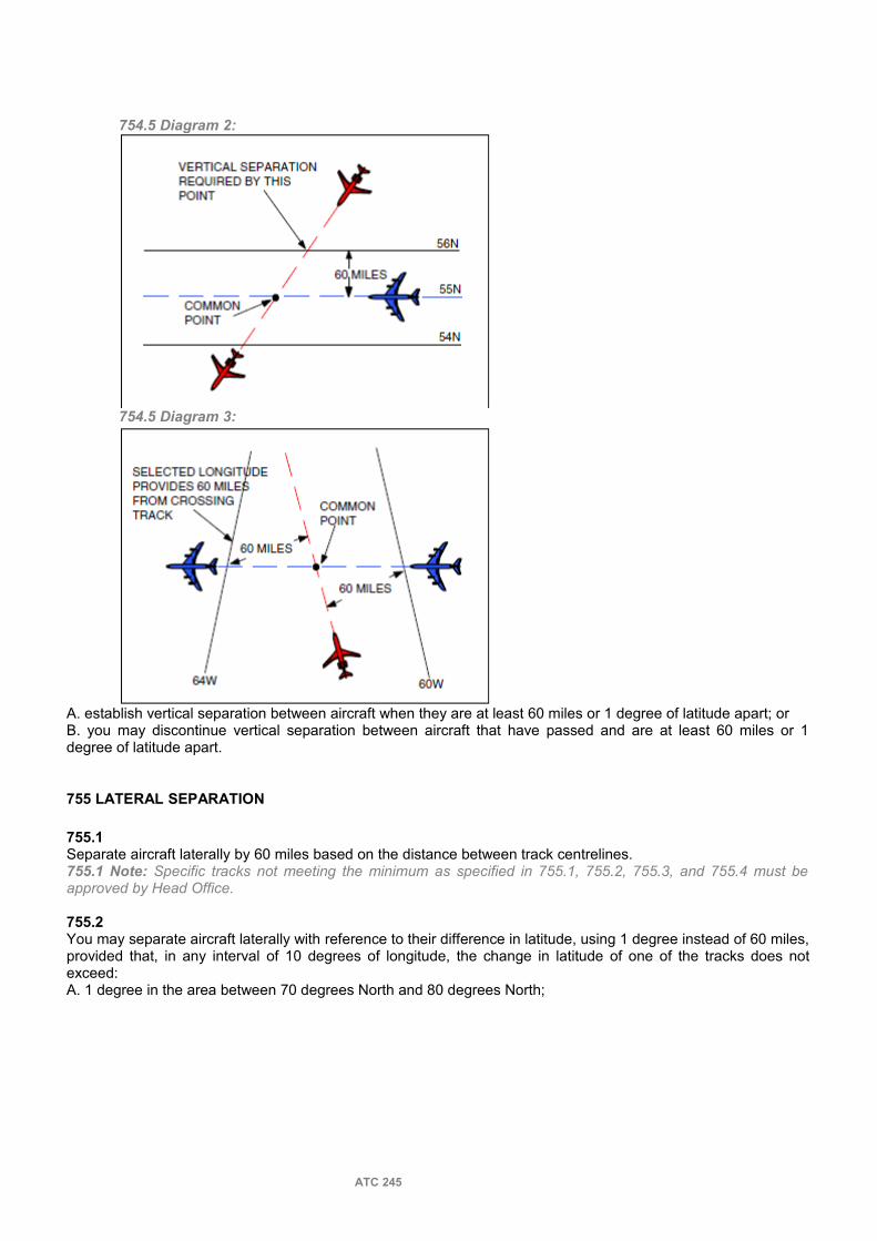
754.5 Diagram 2:
754.5 Diagram 3:
A. establish vertical separation between aircraft when they are at least 60 miles or 1 degree of latitude apart; orB. you may discontinue vertical separation between aircraft that have passed and are at least 60 miles or 1 degree of latitude apart.
755 LATERAL SEPARATION
755.1Separate aircraft laterally by 60 miles based on the distance between track centrelines. 755.1 Note: Specific tracks not meeting the minimum as specified in 755.1, 755.2, 755.3, and 755.4 must be approved by Head Office.
755.2You may separate aircraft laterally with reference to their difference in latitude, using 1 degree instead of 60 miles, provided that, in any interval of 10 degrees of longitude, the change in latitude of one of the tracks does not exceed:A. 1 degree in the area between 70 degrees North and 80 degrees North;
ATC 245

755.2 A. Diagram:
B. 2 degrees in the area between 58 degrees North and 70 degrees North; and 755.2 B. Diagram:
C. 3 degrees in the area south of 58 degrees North. 755.2 C. Diagram:
755.3Separate aircraft laterally by 60 miles while they are operating on tracks that:A. are north of 80 degrees North; orB. have a change in latitude which exceeds the allowable limits in 755.2.
755.4Separate aircraft using area navigation systems, from the airspace to be protected for aircraft that are using ground-based NAVAIDs, by 30 miles.
ATC 246

755.4 Diagram:
755.5Apply lateral separation to aircraft on reciprocal tracks that do not coincide, provided:
755.5 Note: Inbound and outbound are in reference to the point of crossing.A. estimates indicate the outbound aircraft will be at least 10 minutes beyond the point where lateral separation is achieved, when the inbound aircraft reaches the point where lateral separation is lost; or
755.5 A. Diagram:
B. estimates indicate the inbound aircraft is at least 10 minutes away from the point where lateral separation will be lost, when the outbound aircraft reaches the point where lateral separation is achieved.
755.5 B. Diagram:
756 LONGITUDINAL SEPARATION
ATC 247

756.1Separate aircraft by 15 minutes if they will follow:A. the same track; or
756.1 A. Diagram:
B. tracks not laterally separated. 756.1 B. Diagram:
756.2Separate aircraft on crossing tracks by using one of the following minima:
756.2 Diagram:
A. 20 minutes, if either aircraft is maintaining a groundspeed less than 340 knots.B. 15 minutes, provided both aircraft are maintaining groundspeeds of 340 knots or greater.
ATC 248

757 LONGITUDINAL SEPARATION — MACH-NUMBER TECHNIQUE
757.1Apply Mach-number technique if required for separation of aircraft entering MNPS airspace.
757.1 Note 1: When reclearing aircraft on initial entry into Domestic airspace and separation is based on Mach-number technique, it is necessary that the Mach-number form part of the clearance.757.1 Note 2: Once accepted as part of the ATC clearance the Mach-number will be adhered to, unless the aircraft obtains ATC approval to change.
757.2When applying Mach-number technique, assign a Mach-number in each clearance issued for the duration of the application.
757.3Ensure that the required separation is being maintained or increased while applying Machnumber technique, by obtaining:A. position reports at significant points that are not more than one hour's flying time apart; andB. as necessary, confirmation from the pilot that the assigned Mach-number is being maintained.
757.3 B. Phraseology:CONFIRM MAINTAINING MACH (number).757.3 B. Note: Requests for confirmation of Mach-number may be done in conjunction with a position report.
757.4Separate aircraft by 10 minutes provided:
757.4 Diagram:
A. the Mach-number technique is used;B. the aircraft are in level flight, climbing, or descending;C. the aircraft are operating on the identical track or continuously diverging tracks;D. the aircraft have reported over a common point; andE. the required longitudinal separation will be maintained until tracks diverge, and when tracks diverge, the required lateral separation and at least 5 minutes longitudinal separation will exist at the point where lateral separation is achieved. 757.4 E. Diagram 1:
ATC 249

757.4 E. Diagram 2:
757.5Separate a faster succeeding aircraft from a slower preceding aircraft by ensuring that not less than 10 minutes is maintained:
757.5 Note 1: Where automated systems provide conflict prediction, there is no requirement to use the diagram to determine the appropriate separation minimum.757.5 Note 2: Groundspeed determined from RNAV position reports or radar displayed information is acceptable.757.5 Note 3: The following table may be used as a rule of thumb to determine the required separation:A. until tracks diverge, and when tracks diverge, the required lateral separation and at least 5 minutes longitudinal separation will exist at the point where lateral separation is achieved; or B. to a point at which another form of separation will be achieved.
ATC 250

757.6You may separate aircraft that have not reported over a common point as specified in 757.4, provided you ensure through the use of radar, DME, or RNAV distance, that the minimum will exist at the common point from which the aircraft will follow an identical track or continuously diverging tracks.
757.6 Diagram:
757.7You may reduce the minimum specified in 757.4 in accordance with the following table, provided:
757.7 Note: If the aircraft will follow continuously diverging tracks and the required lateral separation will be achieved not later than 20 minutes after the preceding aircraft has passed the common point, the requirement to have 5 minutes longitudinal separation where lateral separation is achieved does not apply.
A. the preceding aircraft is maintaining a greater Mach-number than the succeeding aircraft; andB.
ATC 251

1. the aircraft have reported over a common point; or 757.7 B. 1. Note: The fix tolerance area for the fix derived from ground based NAVAIDs shall not exceed that of an NDB at the appropriate altitude.
2. radar, DME, or RNAV distance is used to ensure that the appropriate time interval exists and will exist at the common point.
ATC 252

760 REDUCED VERTICAL SEPARATION MINIMUM (RVSM) CONTROL PROCEDURES
761 APPLICATION
761.1Apply the criteria and procedures in this section to RVSM certified aircraft only and while operating within the RVSM airspace or RVSM Transition airspace.
761.2Except as indicated in 761.3, do not issue a clearance to a non-RVSM certified aircraft into RVSM airspace.
761.2 Note: If informed that a RVSM certified aircraft that is in flight outside RVSM airspace is no longer certified due to an equipment failure, consider the aircraft as non-certified and do not issue a clearance to enter RVSM airspace.
761.3With prior approval, the following non-RVSM certified aircraft may be issued a clearance into RVSM airspace:
761.3 Note: Except for state aircraft, aircraft operators are to obtain prior approval from the first ACC that provides control in RVSM airspace, normally not more than 12 hours and not less than 4 hours prior to the intended departure time.
A. a state aircraft; 761.3 A. Note: State aircraft do not require prior approval to operate in RVSM airspace.
B. an aircraft on an initial delivery flight;C. an aircraft that was formerly RVSM certified but has experienced an equipment failure and is being flown to a maintenance facility for repair/recertification;D. a mercy or humanitarian flight;E. a photographic survey aircraft; or
761.3 E. Note: Approval to operate in RVSM airspace is only applicable to the area(s) of surveying or mapping operations and not for that portion of flight transiting to/from the area(s).
F. an aircraft conducting a flight check of a NAVAID. 761.3 F. Note: Approval to operate in RVSM airspace is only applicable for conducting flight check operations and not for that portion of flight transiting to/from flight checks.
761.4You may issue a clearance to a non-RVSM certified aircraft that will permit it to climb or descend through RVSM airspace provided:A. the clearance permits a continuous climb or descent through RVSM airspace; andB. the aircraft will be separated from all aircraft operating at RVSM designated flight levels by the applicable lateral or longitudinal separation minimum.
762 DIRECTION OF FLIGHT
762.1Within RVSM Transition airspace assign an altitude appropriate to the aircraft track in accordance with RVSM cruising flight levels. Transition aircraft to an altitude appropriate to the aircraft track prior to exiting the RVSM Transition airspace.
763 VERTICAL SEPARATION
763.1You may separate aircraft vertically by 1,000 feet provided both aircraft are:A. RVSM certified; andB. operating within RVSM airspace or RVSM Transition airspace.
763.2Ensure vertical separation is established in accordance with 472.2 and 763.1 to all aircraft prior to exiting the RVSM Transition Area.
763.3Do not provide a non-RVSM certified aircraft with the reduced separation criteria that apply only to RVSM certified aircraft.
ATC 253

763.3 Note: Consider aircraft in formation as non-RVSM certified.
763.4Do not provide reduced vertical separation between a RVSM certified aircraft and the upper limit of Class F airspace.
764 CONTINGENCY PROCEDURES
764.1If informed that a RVSM certified aircraft operating with RVSM airspace is no longer certified due to an equipment failure:A. obtain the pilot’s intentions;B. attempt to:
1. establish increased vertical separation;or2. establish another form of separation.
C. if possible, provide a clearance out of RVSM airspace;D. pass traffic information, if necessary; and E. advise adjacent facilities or sectors of the situation, if appropriate.
764.2If an aircraft reports greater than moderate turbulence and is unable to maintain the cleared flight level:A. if the aircraft is within 5 minutes of another aircraft at 1000 feet separation, attempt to establish 2000 feet separation or applicable lateral or longitudinal separation minimum;
764.2 A. Note: A clearance may be issued to another RVSM flight level that is not experiencing the turbulence.
B. if necessary, pass traffic information; and C. report the turbulence to the supervisor or shift manager.
764.2 C. Note: A supervisor or shift manager may temporarily suspend RVSM in selected areas and/or flight levels.
ATC 254
770 SUPERSONIC TRANSPORT PROCEDURES
771 SST GENERAL
771.1In addition to the procedures contained in Parts 4, 5 and 7, apply the following to SST aircraft while operating in Domestic Airspace.
771.1 Note: These procedures may differ from division to division.
772 SST SEPARATION
772.1In addition to 472.2, apply 4000 feet between SST aircraft and any other aircraft when the SST aircraft is at or above FL450.
772.1 Note: SST aircraft are not RVSM certified.
773 PROCEDURES
773.1With respect to an SST aircraft do not:A. level off or conduct a step climb when it has started its acceleration climb;
773.1 A. Note: An interrupted climb would severely impact fuel consumption, and may prevent the aircraft from reaching its intended destination.
B. approve a change to the supersonic portion of the SST route; or 773.1 B. Note: SST aircraft can be considered RNPC and MNPS certified.
C. issue an early acceleration climb or a late deceleration descent. 773.1 C. Note: As part of the authorization for the conduct of supersonic operations, Transport Canada, approves flight planned acceleration and deceleration points, taking into consideration the impact of the sonic boom on inhabited areas.
ATC 255

780 SPECIAL AVIATION EVENTS
781 CONTROLLERS RESPONSIBILITIES
781.1Provide taxi instructions and take off and landing clearances to air show aircraft.
781.2Unless an emergency exists, do not attempt to “control” or interfere with performing aircraft and vehicles during their air show act.
781.2 Note 1: Airshow acts are usually subject to Local Events Division department.
781.3Provide control services to non-participating local and itinerant aircraft in accordance with the agreement between the airport authority and the air show organizer during air show hours.
781.4Do not interrupt an air show performance to accommodate a routine arrival or departure by a non-participating aircraft. Short delays may be required for some aircraft.
781.5Do not relieve pilots of the requirement to have a functioning transponder in airspace where it is normally required.
781.6Monitor the weather conditions and alert the air show authority or the airshow representative of changes that could be significant to the event
ATC 256

PART 8 — ALTITUDE RESERVATIONS AND MILITARY DIRECTIVES
800 _ ALTITUDE RESERVATIONS — GENERAL
801 APPLICATION802 OBJECTIVES
ATC 257

PART 8 — ALTITUDE RESERVATIONS AND MILITARY DIRECTIVES
800 ALTITUDE RESERVATIONS — GENERAL
801 APPLICATION
801.1Apply the local Division SO-rules, procedures, and separation minima in the provision of altitude reservation service.
801.1 Note: Altitude reservations are employed when a number of aircraft must be moved with less than standard IFR separation between aircraft, or when a number of aircraft must operate within prescribed altitudes, times or areas.
802 OBJECTIVES
802.1The objectives of the Altitude Reservation Service are:A. to apply rules, procedures, and separation minima to ensure the most efficient use of airspace, commensurate with the requirements of all agencies concerned in planning and applying altitude reservation service;B. to ensure coordination between all agencies concerned in planning ALTRVs; andC. to disseminate, as required, information concerning ALTRVs.
ATC 258

PART 9 — CORRECT FILLING OF RADAR LABELS900 _ LABELLING
901 RECOMMENDED COMPLETION OF IFR STRIPS902 SPECIAL ABBREVIATIONS AND SYMBOLS
ATC 259

PART 9 —CORRECT FILLING OF RADAR LABELS
900 LABELLING
901 RECOMMENDED COMPLETION OF IFR STRIPS
901.1Since IVAC is using Electronic Flight Strips the only editable fields apart from the E-FPL itself, are WP and CL fields.
Note 901.1: WP corresponds to the field used for clearances affecting lateral navigation and CL for clearances affecting vertical navigation.
901.2It is recommended to use the WP and CL fields as follows:
Note 901.2: Division or local procedures may differ.A. for lateral navigation WP field would be used and it is expected to be filled with a maximum of 3 characters; except for:
Example 901.2.AIf a traffic is cleared direct to XEBAR fix, XEB should be inserted in the field WP. Diagram 901.2.A
1. When using a published procedure which is being differentiated through a designator code.Example 901.2.A.1A traffic is cleared for AMTOS3C arrival, AMT3C should be inserted in the field WP
2.When using the ICAO code for the destination airport, where only the last two letters would be used.Example 901.2.A.2A traffic is following his flight plan as filled, final destination is LFPG, PG would be inserted in the WP field since LF letters are redundant.
3. When using codes related to special situations or approach procedures.Example 1 901.2.A.3A traffic requests vectors for app, ATC would insert REQVCT to point out this special situation to fellow ATC.Example 2 901.2.A.3A traffic is cleared for an ILS approach for runway 30L, then I30L would be inserted.
B. for vertical navigation, CL field would be used and it is expected to be filled with the flight level or altitude cleared for the flight.
901.3The WP field should show the last two letter of the ICAO airport code unless:A. otherwise instructed by local proceduresB. the destination airport is beyond limits
Note 901.3.B: When the destination airport is out of the ATC responsabilities, then the first 3 letters of the FIX or NAVAID where the flight will abandon the airspace should be inserted.
C. Any other relevant clearance affects the flight
902 SPECIAL ABBREVIATIONS AND SYMBOLS
902.1A.Abbreviations found in ABBREVIATIONS or the following ones may also be used in strip marking.
ATC 260

abeam ABMabove ABVactual time of departure ATDafter passing APSGadvise ADZaltitude reservation ALTRVapproach (unspecified) AARC clockwise ARC CARC counter-clockwise ARC CCas soon as possible ASAPat @at least one thousand feet on top 10/⊕at or above ↑at or below ↓back course BCbefore proceeding on course BPOCbelow BLOcancel IFR IFRcentre-stored Cclearance cancelled if not airborne by (time/event) CC (time/event)clearance valid at (time/event) CV (time/event)clearance validation required CVRcleared through eastbound >cleared through westbound <cleared to the TACAN 180radial 10 DME fix T180/10cleared out of controlled airspace Bcleared to enter (or join) controlled airspace Eclimbclimb from 6,000 to 8,000 60 80climb to 4,000 in accordance with thevisual flight rules 40VFRclimb with at least 1,000 feet vertical separationbelow (aircraft identification) 10BLO (ident)compressingcross Xcross (fix) at 11,000 X(fix)110cross (fix) at 15,000 or above X(fix)150↑cross (fix) at 15,000 or below X(fix)150↓depart Ddescenddescend with at least 1,000 feet verticalseparation above (aircraft identification) 10ABV (ident)direct →do not pass to air defence radar NOPAReastbound EBestimated time of arrival ETAestimated time of departure ETDexpanding ↕expect approach clearance at (time) EAC (time)expect further clearance at (time) EFC (time)flight level FLflight plan route F/Pfull route clearance F
great circle G/Chold Hhold (direction from fix, in relation tocompass points) H-(direction)if communications fail ICFif not possible INPimmediately IMDinbound IBinformation passed /information passed andrevised information passedinterceptleave Lleft turn(s) LTmaintain Mmissed approach MAno delay expectednorthbound NBnot above NAnot before NTBnot below NBLOnot later than NLon course OCoutbound OBover OVRproceed on course POCpresent position PPprocedure turn PTproposed Ppublished hold PHradial Rreport RPTreport leaving RLreport established REreport passing RPreport reaching RRrequest altitude change en route RACEright turn(s) RTrunway heading RHscheduled shutdown SSDsouthbound SBSTAR (Standard Arrival Route)TACAN Ttake off T/Otick marktransponder TSturn left TLturn right TRunserviceable U/Suntil TILuntil further advised UFAuntil further notice UFNwarning indicator(control action must be implemented) W (in red)westbound WBwhile in controlled airspace WICA
B. use the following abbreviations for the instrument approach procedure identification: BC — localizer back courseCI — converging ILSCT — copter TACAND —DMEI —ILSI2 — ILS CAT IIK — contact
LDA — localizer type directional aidLOC — localizerN — NDBO —VORP —PART —TACANV — visual
ATC 261

PART 10 — SOFTWARE OPERATION1000 _ GENERAL
1001 SOFTWARE OPERATION
ATC 262

PART 10 — SOFTWARE OPERATION
1000 GENERAL
1001 SOFTWARE OPERATION
1001.1.For software operation refer to the ATC client manual.
1001.2.ATC are expected to study the ATC client manual and know its operation.
ATC 263

ANNEX I — EMERGENCY CHECKLISTS
ATC 264
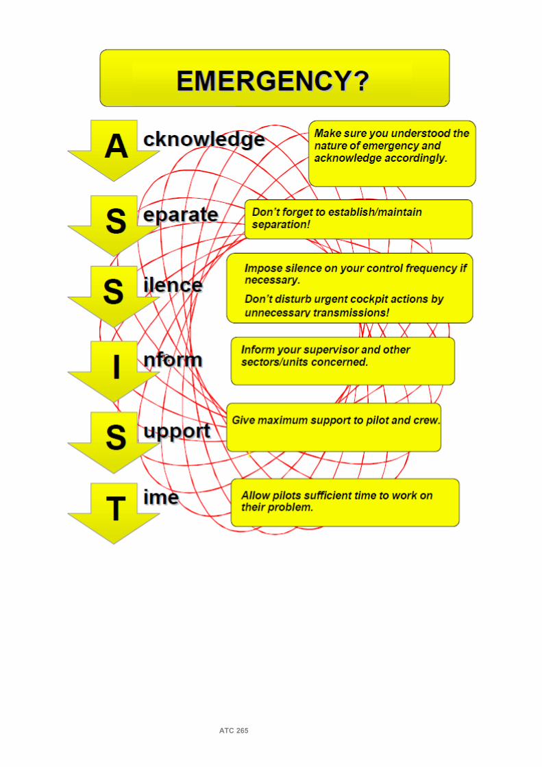
ATC 265

ATC 266

ATC 267

ATC 268

ATC 269

ATC 270

ATC 271

ATC 272

ATC 273

ATC 274

ATC 275
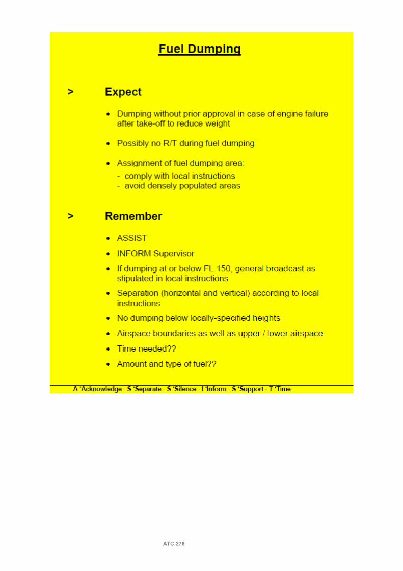
ATC 276
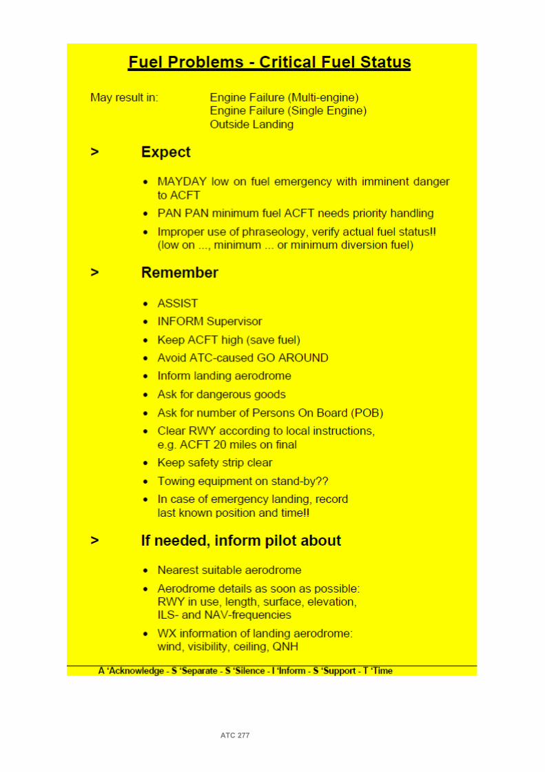
ATC 277

ATC 278

ATC 279

ATC 280

ATC 281

ATC 282

ATC 283

ATC 284

ATC 285

ATC 286

ATC 287

ANNEX III— RADAR CONTROL - COLLISION AVOIDANCE CONCEPTS
Refer to CAP
ATC 289

ANNEX IV—LINKS FOR LOCAL SOPTo be completed. By the time being, all ATCs are encouraged to visit their local division webpages.
ATC 290


