18
Atmospheric Correction for Ocean Color Remote Sensing Geo 6011 Eric Kouba Oct 29, 2012
| Date post: | 03-Jan-2016 |
| Category: |
Documents |
| Upload: | alan-jeremy-porter |
| View: | 220 times |
| Download: | 1 times |

Atmospheric Correction forOcean Color Remote Sensing
Geo 6011
Eric Kouba
Oct 29, 2012

Ocean Color Overview
Measured data Top of Atmosphere Radiance
Need to do Atmospheric Correction
Desired signal Water-Leaving Radianceor Remote Sensing Reflectance
****************************************************************************Use other equations and methods...
Proxy parameter e.g. Chlorophyll-A concentration
Biological parameter Phytoplankton primary productivity
Desired goal Information about health of the ocean

Sunlight to Surface to Sensor
1. Solar spectrum at top of atmosphere
2. Atmospheric absorption, scattering, etc
3. CloudsThin clouds allow some visibility
4. Reflection from top layer of oceanCase 1 clear waters (tens of meters)Case 2 turbid waters (less penetration)
5. Atmospheric absorption, scattering, etc
6. Radiance measured by satellite sensorOnly 10% to 20% of signal comes from ocean waters
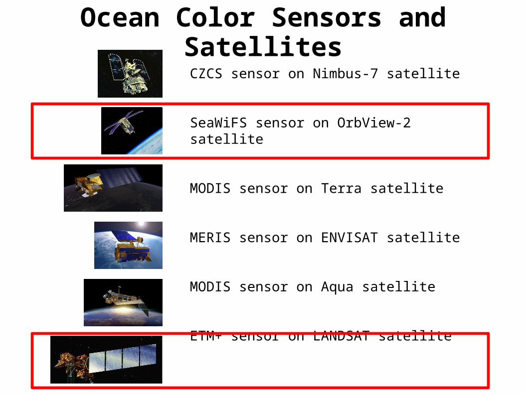
Ocean Color Sensors and Satellites
CZCS sensor on Nimbus-7 satellite
SeaWiFS sensor on OrbView-2 satellite
MODIS sensor on Terra satellite
MERIS sensor on ENVISAT satellite
MODIS sensor on Aqua satellite
ETM+ sensor on LANDSAT satellite

Sensors and Satellites - Pastwww.ioccg.org

Sensors and Satellites - Currentwww.ioccg.org

Sensors and Satellites - Plannedwww.ioccg.org

Major types of correction methodsKnow which one your software uses
Dark object subtraction
Invariant object subtraction
Histogram matching
Cosine estimation of atmospheric transmittance
Contrast reduction
Path extraction
Spectral shape matching method -> CAAS
Others

SeaWiFSseadas.gsfc.nasa.gov
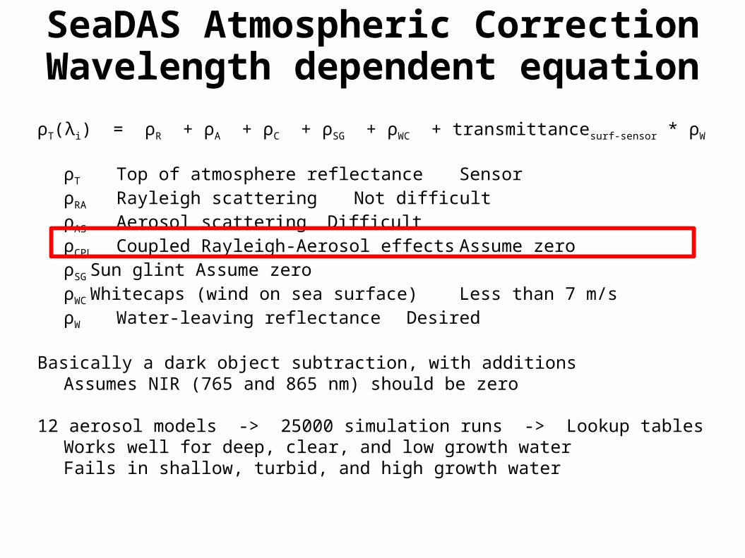
SeaDAS Atmospheric CorrectionWavelength dependent equation
ρT(λi) = ρR + ρA + ρC + ρSG + ρWC + transmittancesurf-sensor * ρW
ρT Top of atmosphere reflectance SensorρRA Rayleigh scattering Not difficultρAS Aerosol scattering DifficultρCPL Coupled Rayleigh-Aerosol effects Assume zeroρSGSun glint Assume zeroρWC Whitecaps (wind on sea surface) Less than 7 m/sρW Water-leaving reflectance Desired
Basically a dark object subtraction, with additionsAssumes NIR (765 and 865 nm) should be zero
12 aerosol models -> 25000 simulation runs -> Lookup tablesWorks well for deep, clear, and low growth waterFails in shallow, turbid, and high growth water

Options when standard correction fails
Flag and ignore regions that are difficult to process
If available, use SWIR instead of NIR for dark subtractionbut MODIS has SWIR signal to noise problem
Simultaneous spectroradiometer measurements in field of viewbut Not practical for daily operations
Take spectroradiometer measurements nearbybut Atmospheric parameters vary in time and space
Use other algorithm with standard atmospheresbut Atmospheric parameters vary in time and space
Use algorithm to get aerosol correction from within image datae.g. Shanmugam (2012)

aeronet.gsfc.nasa.gov
CAAS - Basic Equation
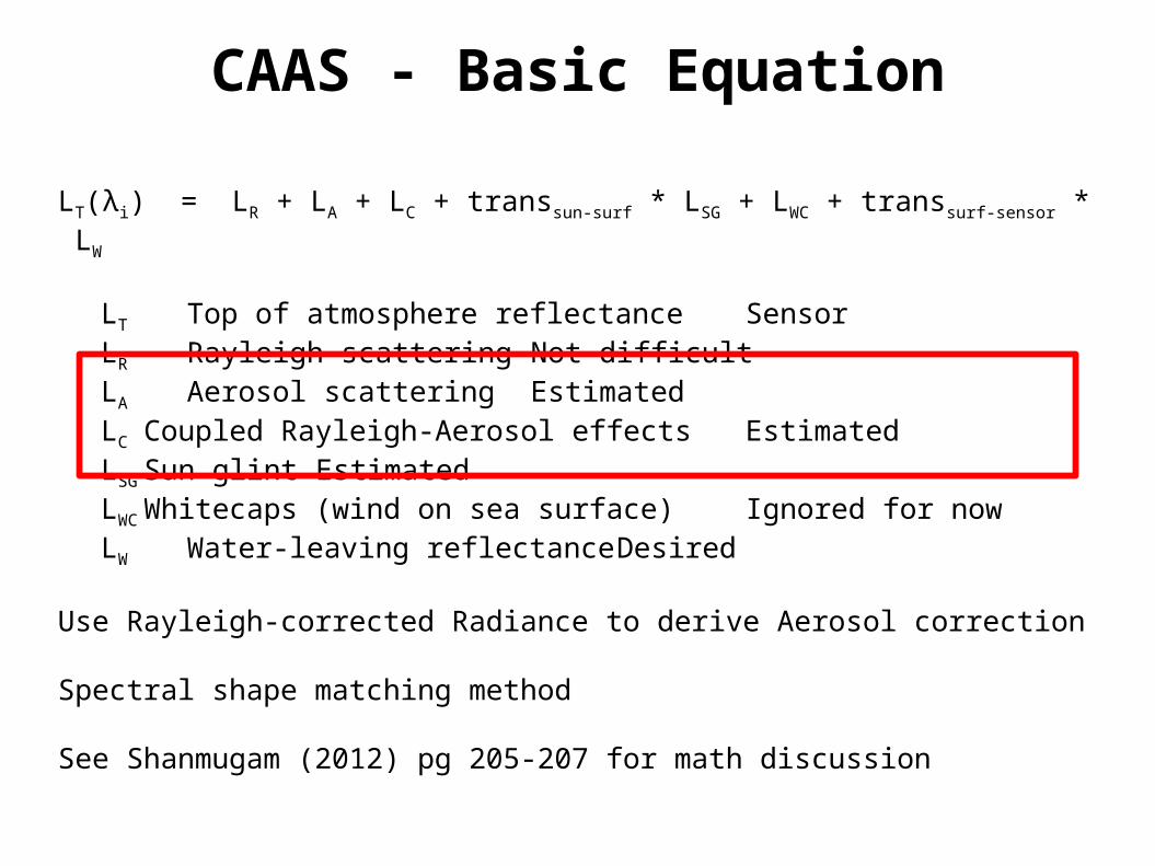
LT(λi) = LR + LA + LC + transsun-surf * LSG + LWC + transsurf-sensor * LW
LT Top of atmosphere reflectance SensorLR Rayleigh scattering Not difficultLA Aerosol scattering EstimatedLC Coupled Rayleigh-Aerosol effects EstimatedLSGSun glint EstimatedLWC Whitecaps (wind on sea surface) Ignored for nowLW Water-leaving reflectance Desired
Use Rayleigh-corrected Radiance to derive Aerosol correction
Spectral shape matching method
See Shanmugam (2012) pg 205-207 for math discussion


Conclusions
NIR dark subtraction fails in shallow, turbid, and high growth waterLike counting worldwide trees, but failing in the jungle
Aerosol modeling remains difficult
Atmospheric correctionis important...
Choose wisely

Questions?


