36
Hawkesbury City Council attachment 1 to item 181 Applicant's Planning Proposal date of meeting: 30 September 2014 location: council chambers time: 6:30 p.m.

Ha
wk
es
bu
ry
C
ity
C
ou
nc
il
a t t a c h m e n t 1
t o
i t e m 1 8 1
Applicant's Planning Proposal
d a t e o f m e e t i n g : 3 0 S e p t e m b e r 2 0 1 4
l o c a t i o n : c o u n c i l c h a m b e r s
t i m e : 6 : 3 0 p . m .


FALSON and associates pty ltd ABN 46 064 619 790
Urban and Rural Planning Consultants
___________________________________________________________________________________________
Ph: 4572 2123
PO Box 3127 Fax: 4572 2173
GROSE VALE NSW 2753 email: [email protected]
PLANNING PROPOSAL (STATEMENT IN SUPPORT OF REZONING) RESIDENTIAL SUBDIVISION 24 GREENWAY CRESCENT, WINDSOR
January 2014 (Ref: 101039) Prepared by Glenn Falson BA; LG(Ord4); DTCP; M.EnvL; MPIA
COPYRIGHT: The concepts and information contained within this document are the property of Falson & Associates Pty Ltd. Use or copying of this document in whole or in part without the written permission of Falson & Associates Pty Ltd constitutes an infringement of copyright.

FALSON and associates pty ltd
Planning Proposal – subdivision – 24 Greenway Crescent, Windsor
2
Contents EXECUTIVE SUMMARY ....................................................................................................... 4
INTRODUCTION ..................................................................................................................... 5
The Planning Proposal ................................................................................................................. 5
Background .................................................................................................................................... 6
DESCRIPTION OF LAND AND SURROUNDING LOCALITY ....................................... 6
Location .......................................................................................................................................... 6
Site description.............................................................................................................................. 6
Locality Description ...................................................................................................................... 7 Topography ................................................................................................................................. 7 Soils ............................................................................................................................................ 7 European Heritage ...................................................................................................................... 8 Aboriginal Cultural Heritage ........................................................................................................ 9 Landscape, Visual and Open Space Values .............................................................................. 9 Ecology ....................................................................................................................................... 9 Bushfire ..................................................................................................................................... 10 Access and Transport ............................................................................................................... 11 Utilities and Services Infrastructure .......................................................................................... 11 Community Facilities and Human Services .............................................................................. 11 Alternative Land Uses ............................................................................................................... 11
Subdivision Design ..................................................................................................................... 12
STATUTORY PLANNING POLICIES AND CONTROLS ............................................... 12
Land Use Zoning ......................................................................................................................... 12
State Planning Controls and Policies ....................................................................................... 13 Sydney Regional Environmental Plan No 9 – Extractive Industry (No 2 – 1995) ..................... 13 State Environmental Planning Policy 44 – Koala Habitat ......................................................... 13 SEPP5 – Remediation of Land ................................................................................................. 13 SREPP No 20 – Hawkesbury Nepean River ............................................................................ 14
Regional Planning Controls and Policies ................................................................................. 15 Sydney Metropolitan Strategy ................................................................................................... 15
Local Planning Controls and Policies ....................................................................................... 16 Hawkesbury Local Environmental Plan 2012. .......................................................................... 16 Hawkesbury Residential Lands Strategy 2010. ........................................................................ 16 Hawkesbury Employment Lands Strategy 2008. ...................................................................... 16 Community Strategic Plan 2013-2032 ...................................................................................... 16 Our City Our Future - Rural Rezoning Policy 1998 ................................................................... 17
MATTERS TO BE ADDRESSED IN A PLANNING PROPOSAL ................................... 19
JUSTIFICATION STATEMENT (S 55(1) OF THE ACT .................................................. 19
Part 1 - Objectives or Intended Outcomes ................................................................................ 19
Part 2 - Explanation of Provisions ............................................................................................. 20
Part 3 - Justification .................................................................................................................... 20
Part 4 - Mapping........................................................................................................................... 33
FALSON and associates pty ltd
Planning Proposal – subdivision – 24 Greenway Crescent, Windsor
3
Part 5 – Community consultation .............................................................................................. 33
Part 6 – Project Timeline ............................................................................................................. 33
CONCLUSION ........................................................................................................................ 34

FALSON and associates pty ltd
Planning Proposal – subdivision – 24 Greenway Crescent, Windsor
4
Executive Summary The site at Windsor comprises of a single allotment containing approximately 1.6ha. It is located on the western fringe of the Windsor Township and partly joins St Matthews Anglican Church cemetery area to the rear of the church building. Council’s Residential Strategy has identified specific areas / localities that are considered by the Council as suitable for further investigation for urban expansion and in a range of lot sizes from traditional small residential lots to larger periphery lots that might form a transition from the denser urban areas to the rural surrounding areas. The site is adjacent to an area identified within Council’s strategy for investigation. Preliminary site investigations have been carried out which has demonstrated that the land is capable of being subdivided into a number of lots that would be consistent with other lands in the vicinity and would form an appropriate component of residential expansion at Windsor. Whilst the site is partly flood liable, it is only marginally so and any future housing would be on land at or above the 1:100 flood level or only marginally below it. Importantly all dwellings would be at the 1:100 level plus 0.5m so as to conform to current flood development philosophy. Whilst part of the site is above the 1:100 level the site also adjoins higher land and has a continuing egress to land also above the 1:100 level.
Water, electricity, telephone and transport services are currently available to the site boundaries. A new internal road would be created and each lot would have appropriate access. The conclusion is that the site is appropriate for subdivision as proposed, would remain an isolated rural land anomaly if not developed and is too important a site to not be developed. It is concluded that the current RU2 Rural Landscape zone boundary is inappropriate and should be considered for alteration so as to be consistent with adjoining lands and the R2 Low Density Residential zone. At the same time Council may wish to include the rear of two adjoining properties into the rezoning as these currently are split between the RU2 and R2 zones. There appears to be no good reason why all of these adjoining properties should not be zoned R2. These properties front Greenway Crescent and are Lots 10 and 11 DP 1095712. As an alternative to actually changing the zone description it may be that Council considers it more appropriate to just alter the current Lot Size Map to account for subdivision as proposed. We understand that the general market for all types of land within the Hawkesbury LGA is strong and consistent with a short supply of lots including rural, rural/residential, and residential.

FALSON and associates pty ltd
Planning Proposal – subdivision – 24 Greenway Crescent, Windsor
5
It has been identified that there is a need for an additional 5-6,000 dwelling sites in the Hawkesbury LGA to 2031. Existing zoned areas are mostly built out hence the need identified within Council’s strategy to look for additional sites including those around the perimeter of existing towns and villages. The subject proposal will assist in satisfying, in some way, this identified demand.
Introduction
The Planning Proposal Falson & Associates Pty Ltd has prepared this Planning Proposal on behalf of the landowners and it is submitted to Hawkesbury City Council to request that the subject land be ether rezoned from its current RU2 Rural Landscape zone to be incorporated into the adjacent R2 Low Density Residential zone or as an alternative that the Lot Size Map be altered so as to reflect generally the lot sizes in the proposed subdivision. This Planning Proposal has been prepared in accordance with section 55 of the Environmental Planning and Assessment Act 1979 (EP&A Act) and the guidelines prepared by the Department of Planning and Infrastructure entitled “A guide to preparing Planning Proposals”, dated October 2012. This Planning Proposal is in support of a rezoning proposal for land that adjoins the existing residential zone in Greenway Crescent, Windsor. The premise of the proposal is that it recognizes that the subject land is, prima facie, suitable for low density residential use and would be an appropriate extension of residential Windsor. It is concluded that subdivision of this land is appropriate in the circumstances of the case and would be consistent with the direction identified in Council’s recent Residential Strategy. The report also had regard to a Statement of Heritage Impact carried out for the property and which commented on the subdivision proposal. This statement by Archnex Designs concluded: “The subject property would appear well-suited to development in the form proposed. Its relatively lower elevation compared to St Matthews Church and the screening afforded by the existing development along Greenway Crescent in relation the former in and stables, and the vegetative screen between the site and Claremont Cottage will afford sufficient separation of the site from the setting of the three items. In my opinion, provided that the external materials, finishes and colours of the fabric of future development is appropriately recessive, there will be no adverse heritage impacts on the items.”1 Attached to this submission is a draft plan of subdivision for ten (10) low density residential lots that range from 460m² to 7,951m2. Most of the lots are in the
1 Statement of Heritage Impact, December 2013, page 10.

FALSON and associates pty ltd
Planning Proposal – subdivision – 24 Greenway Crescent, Windsor
6
450²-700m² range approximately with one large residual lot having an area of 7951m². An LEP Gateway determination will allow for any further detailed site investigation to occur where necessary although there is considered to be prima facie evidence that the site can be developed by a subdivision and subsequent dwellings and that no further studies are required in conjunction with this Planning Proposal or its process to Gateway determination and beyond.
Background
The Hawkesbury Residential Land Strategy is the document prepared by Council to guide future residential development within the LGA, with the aim of accommodating between 5,000 and 6,000 new dwellings by 2031. The Strategy identifies that existing centres within the Hawkesbury only have the potential to accommodate approximately 600 of the total 5,000 – 6,000 required new dwellings. The remaining 5,400 dwellings need to be provided from greenfield sites and/or development around the periphery of existing towns and villages as recommended in the Strategy as follows: The Hawkesbury Residential Development Model focuses on future residential development in urban areas and key centres.2 The Planning Proposal site’s location and its attributes are considered to meet the criteria within the Strategy.
Description of Land and Surrounding Locality
Location
The site is located approximately 60km north west of the Sydney CBD, and adjoins the Windsor Township. Windsor is situated off the Windsor Road which is a major western Sydney feeder road from Parramatta to Windsor and then via Bells Line of Road over the Blue Mountains and points west. Windsor is one of the five “Macquarie Towns” as set out by Governor Lachlan Macquarie in the infancy of the Sydney colony.
Site description The site is comprised of one allotment being Lot 1 DP 884408. The lot has an area of approximately 1.6ha.
2 Hawkesbury Residential Land Strategy 2010, exec summary, page viii.

FALSON and associates pty ltd
Planning Proposal – subdivision – 24 Greenway Crescent, Windsor
7
There are two dwellings on the land, some rural shedding and some residential fencing and remnant rural fencing. The site has some vegetation along the Greenway Crescent frontage and along the rear southern boundary. The majority of the site is cleared from past turf farm activities. The site did not produce turf however was used in conjunction with large tracts of farming land to the west. The site was used for office, machinery storage and maintenance for the turf farms. The site slopes from the eastern boundary (adjoining St Matthews Church land and some adjoining residential properties and falls towards the western boundary. The site is partly flood liable ranging from approximately 15m AHD to 20m. The site is partly within the 20-25 ANEF contour of noise affectation from RAAF Richmond.
Locality Description
The site adjoins part of the western side of Windsor Township. The lot is irregular in shape and is joined by St Matthews Anglican church grounds, ten (10) residential properties, rural land and is opposite a further six (6) residential properties.
Topography
The land varies in height from approximately 9.5m to 19.5m AHD. There is a plateau area in the middle of the site that is at approximately 15.8m.
Soils The acid sulfate soil map contained within Hawkesbury’s Local Environmental Plan 2012 indicates that the property is partly within a class 5 and partly within a class 4 soil classification. There is no particular requirement for development within these soil class areas unless extensive earthworks are undertaken and when such might be close to waterways etc. Should the planning proposal be supported it is envisaged that a detailed soil analysis would need to be undertaken including recommendations for soil management during construction.

FALSON and associates pty ltd
Planning Proposal – subdivision – 24 Greenway Crescent, Windsor
8
Extract from the Acid Sulfate Soil Classification Map. Subject property shown cross hatched.
Purple colour is class 4 land. Remainder is class 5 land.
European Heritage
The Hawkesbury LGA has a diverse cultural heritage which includes cultural landscapes, roadways, historic buildings and infrastructure. The European heritage dates back to the earliest years of colonial settlement, including four of the five Macquarie Towns.
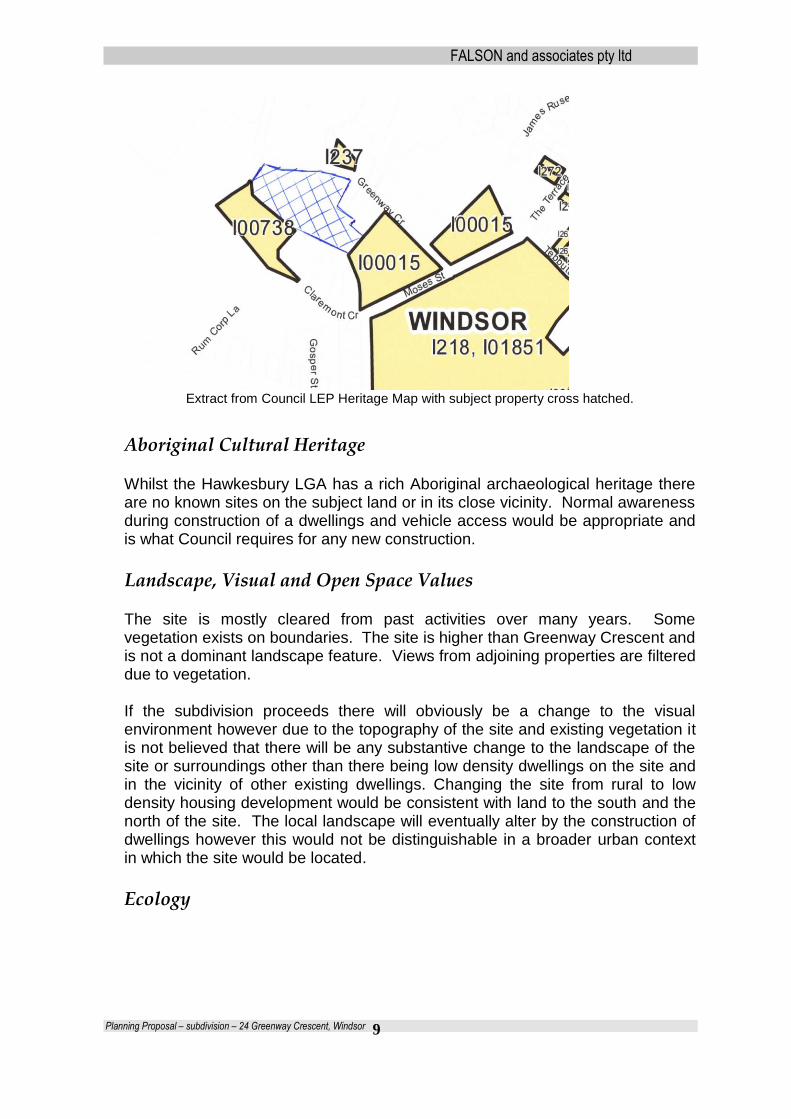
The site does not contain a heritage listed item although is adjacent to St Matthews Anglican Church and Claremont Cottage, each of which are heritage items listed within Council’s LEP as having State heritage significance. On the opposite side of Greenway Crescent (No 29) is a dwelling that was a former inn. This is listed within the LEP as having local heritage significance.
FALSON and associates pty ltd
Planning Proposal – subdivision – 24 Greenway Crescent, Windsor
9
Extract from Council LEP Heritage Map with subject property cross hatched.
Aboriginal Cultural Heritage
Whilst the Hawkesbury LGA has a rich Aboriginal archaeological heritage there are no known sites on the subject land or in its close vicinity. Normal awareness during construction of a dwellings and vehicle access would be appropriate and is what Council requires for any new construction.
Landscape, Visual and Open Space Values The site is mostly cleared from past activities over many years. Some vegetation exists on boundaries. The site is higher than Greenway Crescent and is not a dominant landscape feature. Views from adjoining properties are filtered due to vegetation. If the subdivision proceeds there will obviously be a change to the visual environment however due to the topography of the site and existing vegetation it is not believed that there will be any substantive change to the landscape of the site or surroundings other than there being low density dwellings on the site and in the vicinity of other existing dwellings. Changing the site from rural to low density housing development would be consistent with land to the south and the north of the site. The local landscape will eventually alter by the construction of dwellings however this would not be distinguishable in a broader urban context in which the site would be located.
Ecology

FALSON and associates pty ltd
Planning Proposal – subdivision – 24 Greenway Crescent, Windsor
10
Extract of LEP Biodiversity Map.
The site is included in the Terrestrial Biodiversity Map within Council’s LEP 2012. The map indicates that approximately 25% of the site is classed as “connectivity between significant vegetation” and approximately 10% is “significant vegetation”. If the biodiversity map is assessed in conjunction with the aerial photo of the site it can be seen that the biodiversity map is not accurate as it shows more land containing vegetation than is actually the case. A flora/fauna assessment has not been carried out at this time and it is not believed that one is required if the site is critically looked at. Development of the site can take place without impact on any significant vegetation.
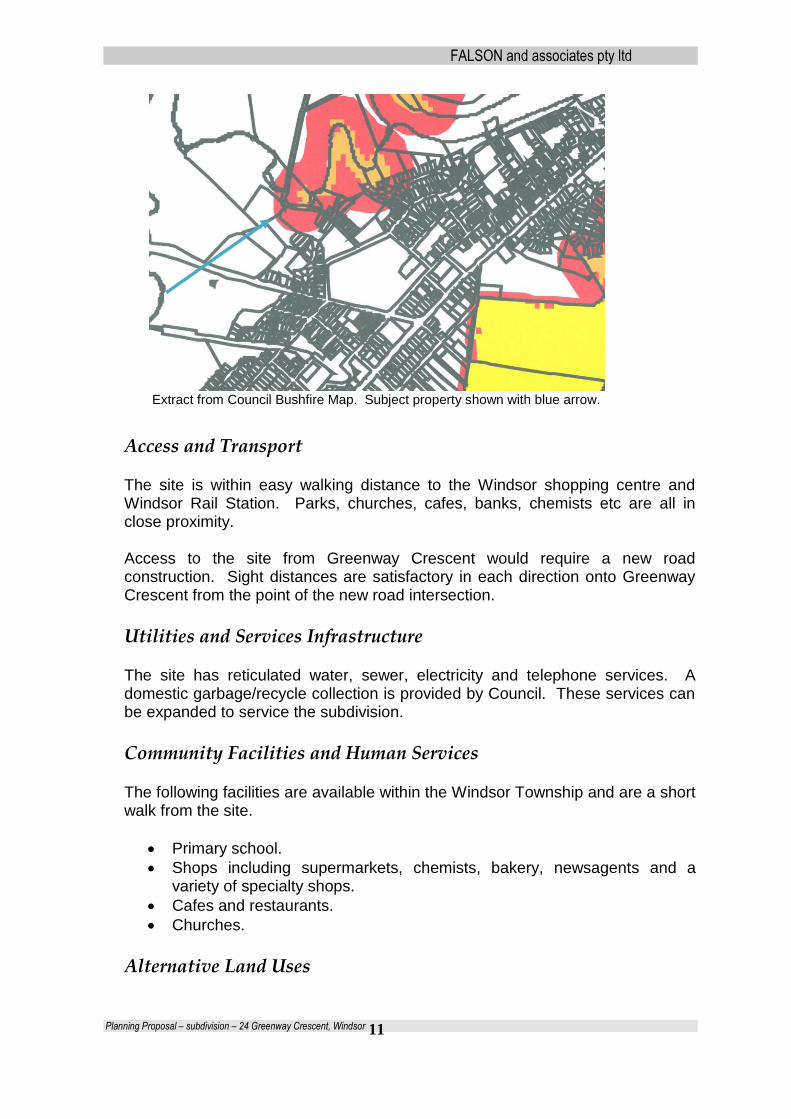
Bushfire
Council’s Bushfire Prone Land Map identifies the majority of the site as being wholly within a Bushfire Prone Land – Vegetation Buffer zone. This is the lowest level of bushfire concern and would not preclude housing development as proposed. Additionally the bushfire prone area includes a large area of the site that has no vegetation so the map is not considered to be an accurate representation of bushfire risk to the property. It is not believed that a detailed bushfire assessment is required. If the Planning Proposal proceeds then subsequent dwellings can be designed to account for fire mitigation in the normal course.
FALSON and associates pty ltd
Planning Proposal – subdivision – 24 Greenway Crescent, Windsor
11
Extract from Council Bushfire Map. Subject property shown with blue arrow.
Access and Transport The site is within easy walking distance to the Windsor shopping centre and Windsor Rail Station. Parks, churches, cafes, banks, chemists etc are all in close proximity. Access to the site from Greenway Crescent would require a new road construction. Sight distances are satisfactory in each direction onto Greenway Crescent from the point of the new road intersection.
Utilities and Services Infrastructure
The site has reticulated water, sewer, electricity and telephone services. A domestic garbage/recycle collection is provided by Council. These services can be expanded to service the subdivision.
Community Facilities and Human Services
The following facilities are available within the Windsor Township and are a short walk from the site.
Primary school.
Shops including supermarkets, chemists, bakery, newsagents and a variety of specialty shops.
Cafes and restaurants.
Churches.
Alternative Land Uses

FALSON and associates pty ltd
Planning Proposal – subdivision – 24 Greenway Crescent, Windsor
12
Council’s LEP 2012 does allow a range of agricultural type uses in the current RU2 zoned land however the only reasonable alternative use for the site would be the current use of a single housing allotment with a very large yard area. As the site is adjacent to St Matthews Anglican Church and other residential development any significant agricultural use of the site would pose a conflict with these adjoining uses.
Subdivision Design
The plan of proposed subdivision shows ten (10) low density residential lots of varying sizes due to topography, slope, flood height, access provisions etc. A small amount of fill material is proposed to level out the middle plateau area of the site. Each of the subsequent dwellings would have habitable floor levels of at least at the 1:100 flood level plus 0.5m.
Preliminary plan of proposed subdivision
Statutory Planning Policies and Controls
Land Use Zoning
The site is currently zoned RU2 – Rural Landscapes under Hawkesbury LEP 2012. The lot size map within the LEP provides for a minimum lot size of 10ha within the RU2 zone. As the site has an area of 1.6ha it is precluded from subdivision under current LEP provisions.
FALSON and associates pty ltd
Planning Proposal – subdivision – 24 Greenway Crescent, Windsor
13
State Planning Controls and Policies
Sydney Regional Environmental Plan No 9 – Extractive Industry
(No 2 – 1995) Sydney Regional Environmental Plan No 9 – Extractive Industry (No 2 1995) [From 1st July 2009 existing Regional Environmental Plans become a “deemed” SEPP under new Division 2, Part 3 of the EP&A Act].
The primary aim of SREP No 9 (No 2-1995) is to facilitate the development of extractive resources in proximity to the population of the Sydney Metropolitan Area by identifying land which contains extractive material of regional significance and to ensure consideration is given to the impact of encroaching development on the ability of extractive industries to realise their full potential. The site is not within the vicinity of land descried in Schedule 1, 2 and 5 of the SREP nor will the proposed development restrict the obtaining of deposits of extractive material from such land.
State Environmental Planning Policy 44 – Koala Habitat State Environmental Planning Policy 44 – Koala Habitat Assessment is applicable. A formal assessment of the site against this Policy has not been done however due to the closeness to residential development, the almost complete absence of vegetation on the site and past rural industrial uses it is unlikely that there is any core habitat on site as defined by SEPP44.
SEPP5 – Remediation of Land
The land has not been used for an agricultural use for many years although has been used for a rural industrial use being for an office and for plant and equipment storage and servicing of machinery and vehicles in association with turf farming on an adjacent lowlands property. Whilst there is no obvious evidence of surface or groundwater pollution as a result of these past uses it is reasonable that a detailed assessment be undertaken prior to any works taking place on the property. It is not believed that these geotechnical investigations need to be carried out at this stage for the planning proposal to proceed as residential development can take place even if site remediation is required. It is noted that the land is within class 4 and 5 Acid Sulfate soils as identified in the Acid Sulfate Soil Map forming part of LEP 2012. There is no particular requirement arising as a result of this classification for residential development to proceed or for this Planning Proposal to proceed.
FALSON and associates pty ltd
Planning Proposal – subdivision – 24 Greenway Crescent, Windsor
14
SREPP No 20 – Hawkesbury Nepean River
Sydney Regional Environmental Plan No 20 (No 2) – Hawkesbury Nepean River [From 1st July 2009 existing Regional Environmental Plans become a “deemed” SEPP under new Division 2, Part 3 of the EP&A Act]. The aim of SREP 20 is to protect the environment of the Hawkesbury – Nepean River System by ensuring that the impacts of future land uses are considered in a regional context. Part 2 of SREP20 provides general planning considerations and recommended strategies. The following specific policies are relevant: 1. Total Catchment Management
Policy: Total catchment management is to be integrated with environmental planning for the catchment.
Strategies
a) Refer the application or other proposal for comment to the councils of each adjacent or downstream local government area which is likely to suffer a significant a significant adverse environmental effect from the proposal.
b) Consider the impact of the development concerned on the catchment. c) Consider the cumulative environmental impact of proposals on the
catchment.
The proposal is for low density residential use of land adjacent to other residential development. The Planning Proposal is for a minor spot rezoning and/or alteration of the Lot Size Map that would have little impact on the river or its catchment. This type of development is envisaged by Council’s Residential Land Strategy. Any cumulative impact would be recognised as suitable in the context of expanding towns and villages as promoted by Council’s strategy.
The subdivision as such will have no impact on water quality although future dwellings on the site would need to be designed in an appropriate manner such that water quality is not adversely impacted. Appropriate mechanisms exist to ensure appropriate water quality measures can be put into place within the subdivision design and layout of access and building envelopes. The site is connected to reticulated sewer and the proposed lots would also have this service provided. 6. Flora and Fauna Policy: Manage flora and fauna communities so that diversity of species and genetics within the catchment is conserved and enhanced. The land is mostly cleared due to past uses. Dwellings could be provided without adverse impact on the little remaining vegetation on the land.

FALSON and associates pty ltd
Planning Proposal – subdivision – 24 Greenway Crescent, Windsor
15
9. Rural Residential Development Policy: Rural residential development should not reduce agricultural sustainability, contribute to urban sprawl, or have adverse environmental impacts (particularly on the water cycle or on flora or fauna). The site is too small and too close to residential development for any meaningful agricultural use to take place. The site is within that generally identified by Council as having some urban potential and thus development is anticipated.
Regional Planning Controls and Policies
Sydney Metropolitan Strategy
The Metropolitan Plan for Sydney 2036 is applicable. The Metropolitan Plan 2036 (the Plan) is the strategic plan that guides Sydney’s growth to 2036. The Plan is an integrated, long-term planning framework that will significantly manage Sydney’s growth and economic development to 2036.
The Plan sets capacity targets for each subregion to facilitate housing and economic growth through providing more jobs closer to home. The Plan anticipates the North West to provide an additional 169,000 dwellings by 2036. The Hawkesbury Residential Land Strategy is Council’s response to implementing the Metro Strategy as far as it applies to the Hawkesbury LGA. The proposal arises out of Council’s Strategy identifying a need for further urban development on the periphery of existing towns and villages subject to relevant criteria.
Draft North West Subregional Strategy
The Metropolitan Plan has been developed to set the framework targets for 10 Metropolitan subregions to provide for major growth in housing and employment. The North West subregional planning strategy, which covers, inter alia, the LGA of Hawkesbury sets the broad direction for additional dwelling and employment growth. This Strategy is split up into a number of sub-regional strategies including the North West Subregional Strategy which provides for the Hawkesbury LGA to accommodate an additional 5,000 dwellings to 2036. The draft subregional strategy acknowledges that the Hawkesbury LGA is largely constrained by the Hawkesbury Nepean flood plain, with limited capacity for

FALSON and associates pty ltd
Planning Proposal – subdivision – 24 Greenway Crescent, Windsor
16
additional growth to the south of the Hawkesbury River due to the risk of flooding. The draft subregional strategy identifies and assumes that the majority of future housing growth within the LGA will need to occur on land located predominantly to the north of the River, in association with existing local centres although does not preclude further development investigation on the southern side of the River. This Planning Proposal is consistent with this objective and is consistent with the further detailed investigation carried out by Council through its Residential Land Strategy.
Local Planning Controls and Policies
Hawkesbury Local Environmental Plan 2012.
Hawkesbury LEP 2012 is the current LEP applying to the site and the Hawkesbury LGA. The land is zoned RU2 – Rural Landscape and the Lot Size Map within the LEP provides that subdivided lots are to have a minimum area of 10ha. To alter the minimum lot size provisions requires a rezoning and/or an alteration of the Lot Size Map through the Planning Proposal process.
Hawkesbury Residential Lands Strategy 2010.
Council adopted the Strategy to guide it in future development of zoned residential lands and lands in proximity of zoned residential lands. The Strategy identifies that existing centres only have the potential to accommodate approximately 600 of the total 5,000 – 6,000 required new dwellings for the LGA as identified in the North Western Sub Regional Strategy. The remaining 5,400 dwellings need to be provided from greenfield sites, infill development and incremental development around existing towns and villages. The proposal is consistent with this
Hawkesbury Employment Lands Strategy 2008.
The Employment Lands Strategy identifies Windsor as having further commercial/employment development in the vicinity of the train station. The subject Planning Proposal would have a positive impact on the Employment Strategy by allowing additional population to serve the commercial growth and existing commercial centre.
Community Strategic Plan 2013-2032
The Hawkesbury Community Strategic Plan 2013− 2032 is based on five themes:

FALSON and associates pty ltd
Planning Proposal – subdivision – 24 Greenway Crescent, Windsor
17
• Looking after people and place • Caring for our environment • Linking the Hawkesbury • Supporting business and local jobs • Shaping our future together Each theme contains a number of Directions, Strategies, Goals and Measures. There is no specific strategy relating to subdivision around villages and the Planning Proposal is not inconsistent with any of the broad themes within the Strategic Plan. Of relevance is that the Planning Proposal is consistent with the “looking after people and place” directions statement in that:
It offers future residents a choice of housing options that are appropriate in the context of the site and overall qualities of the Hawkesbury.
Any population increase resulting from the Planning Proposal will have appropriate infrastructure provision and will accord with relevant rural, environmental and heritage characteristics of the Hawkesbury.
It will provide for appropriate development and promote physical and community infrastructure on both sides of the Hawkesbury River.
Of further relevance is that the Planning Proposal is consistent with the strategy contained in the Community Plan that identifies community needs (additional housing opportunities), establishes an appropriate benchmark and ensures that required services and facilities are available and can be delivered.
Our City Our Future - Rural Rezoning Policy 1998
This policy was adopted in 1998 and has somewhat been superseded by more current policies of Council. However the provisions of the policy are indicated below with comments on each.
1.0 Purpose of the Policy
1. That the following principles be adopted for consideration of rural rezoning to
allow smaller lot subdivision :
a. Fragmentation of land is to be minimised; The land is within an area identified within Council’s subsequent Residential Land Strategy as having urban potential. The land is already fragmented from the main rural lowlands and has characteristics of residential land rather than rural land. Fragmentation of this land (or lands like it) is envisaged by this subsequent strategy. b. Consolidation within and on land contiguous with existing towns and villages be preferred over smaller lot subdivision away from existing towns and villages;
FALSON and associates pty ltd
Planning Proposal – subdivision – 24 Greenway Crescent, Windsor
18
The proposal is consistent with this principle. c. No subdivision along main roads and any subdivision to be effectively screened from minor roads; The site does not front a main road and is not visible from a main road. d. No subdivision along ridgelines or escarpments; The site is not on a ridgeline or in an escarpment area. e. Where on site effluent disposal is proposed, lots are to have an area of at least 1 (one) hectare unless the effectiveness of a smaller area can be demonstrated by geotechnical investigation; The proposed lots would be connected to reticulated sewer services already provided to the locality. f. The existing proportion of tree coverage on any site is to be retained or enhanced; The site has little vegetation and is mostly cleared due to past activities. The subdivision does not propose removal of vegetation and the proposed lots can be provided with retention of vegetation. g. Any rezoning proposals are to require the preparation of Environmental Studies and Section 94 Contributions Plans at the applicant's expense. The rezoning process has altered since this policy of Council. The Gateway Process will dictate whether further studies are required. h. Community title be encouraged for rural subdivision as a means of conserving environmental features, maintaining agricultural land and arranging for the maintenance of access roads and other capital improvements. The subdivision that would result from this Planning Proposal is for low-density residential housing and not rural/residential development. 2. Prepare a draft local environmental plan to alter minimum requirements to average requirements with an absolute minimum requirement sufficient to contain on site effluent disposal. A clause is to be added to Hawkesbury Local Environmental Plan 1989, prohibiting any further subdivision of the residue lot if all subdivision entitlement is exhausted. Not applicable to this Planning Proposal. 3. As a means of encouraging the retention of large holdings, a concessional lot entitlement of up to 50% of the existing legal entitlement be considered under State Environmental Planning Policy No 1 where a land holding has an area in

FALSON and associates pty ltd
Planning Proposal – subdivision – 24 Greenway Crescent, Windsor
19
excess of 40 (forty) hectares and where the subdivision will maximise the area of a single residue lot through the provision of small rural residential lots. Such subdivision proposals are to comply with the principles of this document with a clause to be added to Hawkesbury Local Environmental Plan 1989, prohibiting any further subdivision of the residue lot if all subdivision entitlement is exhausted. Not applicable as land is less than 40ha. 4. Vineyard - In accordance with previous resolutions and resident representations urban development with appropriate services should be supported. Not applicable.
Matters to be addressed in a planning proposal Justification Statement (s 55(1) of the Act
The Planning Proposal has been prepared in accordance with the NSW Department of Planning & Infrastructure A Guide to Preparing Local Environmental Plans (October 2012). The Proposal is structured in the following parts:
1. Objectives or Intended Outcomes; 2. Explanation of Provisions; 3. Justification;
a) Need for the Planning Proposal; b) Relationship to Strategic Planning Framework; c) Environmental, Social & Economic Impact; d) State and Commonwealth Interests;
4. Mapping; 5. Community Consultation; 6. Project Timeline.
Part 1 - Objectives or Intended Outcomes
The proposed local environmental plan would either alter the zone and/or the Lot Size Map as it applies to the land. It is presumed that there will be provisions contained within the draft plan that would limit the number of lots to generally coincide with the planning proposal and that no further subdivision of this land would be permissible once the actual number of lots have been assessed as appropriate. The proposal, albeit in a small way, would assist in meeting the demand for additional housing supply and housing choices within the requirement for an additional 5-6,000 houses by 2031.

FALSON and associates pty ltd
Planning Proposal – subdivision – 24 Greenway Crescent, Windsor
20
Part 2 - Explanation of Provisions
The effect of the planning proposal would be to amend LEP 2012 by:
i. Amending Lot Size Map Sheet LSZ_008DA to change the minimum lot size for the land to a combination of 4,000 square metres, 600m² and 450m² generally in accordance with the proposed subdivision layout with a maximum lot yield of 10 lots
ii. Inclusion of a new provision with LEP 2012 to control the maximum number of lots into which the land can be subdivided, i.e. 12 lots.
Suggested Lot Size Map amendment.
Part 3 - Justification
Section A - Need for the planning proposal.
1. Is the planning proposal a result of any strategic study or report?
Council’s Residential Land Strategy 2010 and the North West Sub-Region Strategy indicate the goal of providing further 5-6,000 dwellings within the Hawkesbury LGA by 2031. The proposal is the result of an indication within the Residential Lands Strategy adopted by Council in 2010 that required a vibrant future for towns including the development around their perimeters commensurate with appropriate access and facilities. The site is on the fringe of the Windsor Township and is considered to be within an area to be considered for development in accordance with Council’s Strategy.

FALSON and associates pty ltd
Planning Proposal – subdivision – 24 Greenway Crescent, Windsor
21
Additionally the Planning Proposal is a result of the landowner’s request for Council to consider further development of the site as being consistent with land within Windsor and nearby to the site. The use of the LEP Gateway determination process will assist in an incremental way, the achievements of the strategic objectives of the Sub-Regional Strategy and Hawkesbury Residential Land Strategy.
2. Is the planning proposal the best means of achieving
the objectives or intended outcomes, or is there a better way?
The current Lot Size Map does not allow for subdivision in the manner proposed. A planning proposal and subsequent zone and/or Lot Size Map amendment is the most appropriate and easiest way to bring about development of the subject land to be consistent with Council’s Residential Lands Strategy. The subject site is in an obvious location to expand the Windsor Township whilst at the same time recognizing heritage constraints of the locality. The Planning Proposal is a key means of achieving the State and Regional objectives and strategic outcomes within the Hawkesbury LGA, specifically the housing targets set by Council’s Residential Land Strategy and the North-West Subregional Strategy. Whilst there are some large lot yield proposals currently with Council and the Department of Planning & Infrastructure the total proposed yield to 2031 can only be addressed if smaller proposals such as this are included alongside larger proposals. In this way there will be a variety of housing choices brought to the market and smaller landholders are seen to be part of the process and an integral component of local communities.
Section B - Relationship to strategic planning framework.
3. Is the planning proposal consistent with the objectives
and actions of the applicable regional or sub-regional strategy (including the Sydney Metropolitan Strategy and exhibited draft strategies?
The Metropolitan Plan for Sydney 2036 The Sydney Metropolitan Strategy – City of Cities: A Plan for Sydney’s Future (the Metro Strategy) was released in 2005 to support growth while balancing social and environmental impacts over 25 years. The Metro Strategy has now been updated and integrated with the Metropolitan Transport Plan towards greater

FALSON and associates pty ltd
Planning Proposal – subdivision – 24 Greenway Crescent, Windsor
22
sustainability, affordability, liveability and equity for generations to come.
Draft North West Subregional Strategy The Draft North West Subregional Strategy identifies and assumes that the majority of future housing growth within the LGA will need to occur on land located predominantly to the north of the River in association with existing local centres however that there are opportunities (such as this) in and around established townships in other areas of the Hawkesbury. The proposal is consistent, albeit in a small way, with the objective of a further 5-6,000 dwellings within the Hawkesbury LGA by 2031.
The Metropolitan Plan for Sydney 2036 can be viewed at http://strategies.planning.nsw.gov.au/MetropolitanStrategyforSydney/PreviousMetropolitanstrategies.aspx The Subregional Strategy can be viewed at http://www.shop.nsw.gov.au/pubdetails.jsp?publication=7957
The table below provides an assessment of the planning proposal against the relevant objectives and actions of the Metropolitan Plan for Sydney 2036 and actions of the Subregional Strategy. The Metropolitan Plan objectives and actions are prefixed with the letters MP, the Subregional Strategy actions are prefixed with the letters NW.
Strategic Planning Framework Assessment
Actions Response
MP Objective B1 To focus activity in accessible
centres
MP Action B1.1 Plan for centres to grow and
change over time.
MP Action B1.3 Aim to locate 80% of all new housing within walking catchments of existing and planned centres of all sizes with good public transport.
NW Action B2.1.1 Councils to consider
planning for houses growth in centres,
particularly those well serviced by public
The proposal assists in carrying out this action. The site is within walking distance of the Windsor Town shops and to the Windsor train station. The proposal provides for a small extension to the Windsor township and is and adjoining other residential development. The site is adjoining an existing urban centre and a logical one for residential lots as proposed. The site is a “one-off” in the locality and would provide an infill on land suited to residential development rather than for rural development as suggested by its current zone. The site provides good access to the local shopping centre in Windsor and has bus routes to Richmond and Castle Hill and a local rail station to Blacktown and Sydney.

FALSON and associates pty ltd
Planning Proposal – subdivision – 24 Greenway Crescent, Windsor
23
transport.
MP Action B3.1 Plan for new centres in existing urban areas and greenfield release areas.
The HRLS recognises that urban growth in the Hawkesbury is severely limited by environmental constraints such as State and National parks, agricultural land values, flooding issues, and noise constraints. This is part of its rationale for promoting limited infill development and development around the periphery of existing towns and villages. The proposal and the site are consistent with this rationale.
NW Action C1.1.3 Hawkesbury Council to
prepare a strategic residential land use study to
consider opportunities for further growth around
local centres to the north of the Hawkesbury
River, cognisant of flooding and flood
evacuation issues.
NW Action C1.3.1 North West councils to plan
for sufficient zoned land to accommodate their
local government area housing target in their
Principal LEPs.
NW Action C2.1.2 Councils to provide in their
LEPs zoned capacity for a significant majority
of new dwellings to be located in strategic and
local centres.
NW Action C2.1.3 North West councils to
ensure location of new dwellings improves the
subregion’s performance against the target for
State Plan Priority E5
NW Action C2.3.2 North West councils to
provide an appropriate range of residential
zonings to cater for changing housing needs.
NW Action C5.1.2 Councils to reflect best practise established by the Growth Centres Commission in land release areas outside the North West Growth Centre.
The Subregional Strategy acknowledges that the LGA is largely constrained by the Hawkesbury - Nepean flood plain, with limited capacity for additional growth to the south of the Hawkesbury River due to the risk of flooding. The Subregional Strategy assumes that the majority of future housing growth within the LGA will need to occur on land located predominantly to the north of the River, in association with existing local centres however also recognises that there are some opportunities for infill and peripheral development around centres to the south of the river. Council’s HRLS was prepared having regard to constraints and opportunities and has carried out the actions required by the Strategy. There is an expectation within the towns and village areas of the Hawkesbury LGA that additional housing opportunities will occur commensurate with projected growth. The Hawkesbury has a demand for a range of housing needs. The proposed subdivision provides for a range of sizes appropriate to the site and accords with the servicing and environmental capacities of the land.
MP Objective D1 To ensure an adequate
supply of land and sites for residential
development
The HRLS was prepared in response to the Subregional Strategy. The HRLS found that there is limited capacity within existing residentially zoned land of the LGA to accommodate more dwellings hence the
FALSON and associates pty ltd
Planning Proposal – subdivision – 24 Greenway Crescent, Windsor
24
MP Action D1.1 Locate at least 70 per cent of
new housing within existing urban areas and up
to 30 per cent of new housing in new release
areas.
MP Action D1.2 - reflect new subregional housing targets in Subregional Strategies and Local Environmental Plans, and monitor their achievement.
MP Objective D2 To produce housing that suits
our expected future needs
MP Action D2.1 Ensure local planning controls
include more low rise medium density housing
in and around smaller local centres.
NW Action D2.3.3 State and local government
to improve existing interchanges and bus
stops.
majority of new dwelling will need to be provided from greenfield sites / extension of the footprint of existing centres. The proposal is on the edge of an existing town and envisaged by Council’s Residential Strategy as being within an area for limited growth. The proposal does not achieve this action. The site is not appropriate for anything other than low density housing.
NW Action E2.1.2 Sydney Metropolitan and
Hawkesbury – Nepean Catchment
Management Authorities to work with agencies
and North West councils to ensure that the
aims and objectives of Catchment Action Plans
are considered in the future management and
planning of local council areas.
NW Action E6.3.1 The Heritage Office to work
with local councils to identify areas in the North
West Subregion to promote and provide access
to heritage places, contribute to local
economies and assist in sustaining heritage
places.
It is assumed that consultation with relevant public authorities including the Hawkesbury – Nepean CMA will be undertaken by Council and/or the DPI. The proposal is consistent with this action. It will provide for housing that utilises good residential land whilst being designed to be sympathetic with local heritage sites.
MP Objective F1 To contain Sydney’s urban
footprint
MP Action F1.1 Focus land release in Growth
Centres.
MP Objective F2 - to maintain and protect
Windsor is already contained by the flood plain. This is one of a small number of opportunities for infill development on the edge of the township and would not be considered to be out of character with the overall Windsor footprint. The site is on the fringe of the Windsor Township area and is consistent with development envisaged by Council’s Residential Land Strategy. The site is not suitable for agriculture due to the

FALSON and associates pty ltd
Planning Proposal – subdivision – 24 Greenway Crescent, Windsor
25
agricultural activities and resource lands
NW Action F2.1.1 Councils to maintain or
enhance the provision of local open space
particularly in centres and along transport
corridors where urban and residential growth is
being located.
NW Action F2.1.2 Council to consider open
space improvement programs with better
facilities to encourage use.
NW Action F2.1.3 Councils to consider
mechanisms to increase the capacity of local
sports fields to a district level.
NW Action F2.1.4 NSW Government and local
councils to development links between smaller
reserves to create diversity and broader user
experience.
NW Action F2.1.5 Local councils to consider
modifying under utilised open space for
informal activities such a skating, basketball,
netball and the establishment of cafes.
proximity of residential housing and heritage sites. There is no open space proposed with this development. If It proceeds the development will not hinder future open space provision.
MP Objective G5 To achieve sustainable water use
MP Action G5.2 Ensure water cycle
management for new release areas and sites
for urban renewal.
NW Action G2.1.5 North West council to continue to promote water sensitive urban design. Objective G6 - to protect Sydney’s unique diversity of plants and animals.
Water sensitive urban design requirements can be incorporated into the subdivision layout and future dwelling construction. The subdivision will not adversely impact on threatened flora/fauna.
MP Objective H3 To provide healthy, safe and inclusive places based on active transport. MP Action H3.1 Design and plan for healthy, safe, accessible and inclusive places.
Limited expansion of Windsor as identified in the HRLS will continue to build on the town’s infrastructure atmosphere. It will encourage additional transport services and promote the town shops and services.

FALSON and associates pty ltd
Planning Proposal – subdivision – 24 Greenway Crescent, Windsor
26
4. Is the planning proposal consistent with council’s local strategy or other local strategic plan?
The Planning Proposal is considered consistent with the following plans of Council:
Residential Land Strategy 2010;
Community Strategic Plan 2013-2032;
Residential Land Strategy 2010 Council’s Residential Land Strategy identifies that existing zoned land within the Hawkesbury only have the potential to accommodate approximately 600 of the total 5,000 – 6,000 required new dwellings to 2031.
Additionally the Strategy requires a vibrant future for towns and villages including the development around their perimeters commensurate with appropriate access and facilities. The site is on the fringe of the Windsor Township and is considered to be within an area to be considered for development in accordance with Council’s Strategy.
The Hawkesbury Residential Land Strategy can be viewed on Council’s website www.hawkesbury.nsw.gov.au.
Community Strategic Plan 2013-2032
As mentioned earlier the Community Strategic Plan contains a number of themes which contains a number of Directions, Strategies, Goals and Measures. There is no specific strategy relating to subdivision around owns
and villages and the Planning Proposal are not inconsistent with any of the broad themes within the Strategic Plan.
The Hawkesbury Community Strategic Plan 2013 - 2032 can be viewed on Council’s website www.hawkesbury.nsw.gov.au.
Our City Our Future – Rural Subdivision Policy 1998 This Policy has largely been superseded by later Council policies. The proposal is consistent with the general philosophies within this policy or is justifiably inconsistent given that the site is within an area now identified as having urban potential.

FALSON and associates pty ltd
Planning Proposal – subdivision – 24 Greenway Crescent, Windsor
27
5. Is the planning proposal consistent with applicable State Environmental Planning Policies?
Yes, the proposal is consistent with the following state policies: SEPP 9 – Extractive Industry
The site is not identified as having a resource nor will its subdivision interfere with resource extraction identified within the SEPP.
SEPP 44 – Koala Habitat There is no evidence of koala on the site.
SEPP 55 – Remediation of Land The site was used for storage of plant and equipment in association with farming of adjoining properties. It would be appropriate to investigate whether remediation is required however past uses would not preclude future residential use of the land.
SEPP (Exempt and Complying Development Codes ) 2008
The planning proposal does not include provisions that contradict of hinder the application of the SEPP.
SREP 20 Hawkesbury Nepean River The proposal is not inconsistent with the strategies contained within SREP 20.
State Environmental Planning Policies and Sydney Regional Environmental Plans can be viewed at http://www.legislation.nsw.gov.au/maintop/scanact/inforce/NONE/0 by clicking on “S” within the “Browse in Force” “EPIs” section.
6. Is the planning proposal consistent with applicable Ministerial Directions (s.117 directions)?
The Minister for Planning and Infrastructure, under section 117(2) of the EP&A Act issues directions that local councils must follow when preparing planning proposals for new local environmental plans. The directions cover the following broad categories:
a. employment and resources
b. environment and heritage
c. housing, infrastructure and urban development
d. hazard and risk
e. regional planning
f. local plan making.

FALSON and associates pty ltd
Planning Proposal – subdivision – 24 Greenway Crescent, Windsor
28
The following section provides an assessment of the planning proposal against applicable Section 117 directions. A full copy of the directions can be viewed at http://www.planning.nsw.gov.au/LinkClick.aspx?fileticket=dOkLhSFp9eo%3d&tabid=248&language=en-AU
Direction 1.2 Rural Zones
Consistency Yes
Comments The proposal is considered to be of minor significance only in terms of impact on the available rural zones and rural/agricultural lands. The site has not been used for any form of rural/agricultural use for many years and is currently required to be mechanically slashed to keep grass and weed infestation at bay.
Due to the location of the site adjacent to residential housing, The Sebel Resort and St Matthews Church the site is arguably not conducive to productive agricultural use due to nuisance arising.
As the proposal is only for ten housing lots, provides a community benefit and is considered to be of minor significance the proposal does not, in our view, warrant the preparation of a specific rural study particularly noting Council’s Residential Strategy that identified sites such as this for town expansion.
1.3 Mining, Petroleum Production and Extractive Industries
Yes
The objective of this direction is to ensure that the future extraction of State or regionally significant reserves of coal, other minerals, petroleum and extractive materials are not compromised by Inappropriate development. The site does not have any identified resource deposits and, in any case, it is unlikely that any extraction would be able to take place in such close proximity to housing development and the Windsor township generally.

FALSON and associates pty ltd
Planning Proposal – subdivision – 24 Greenway Crescent, Windsor
29
3.1 Residential Zones
Yes The objectives of this direction are: (a) to encourage a variety and choice of housing types to provide for existing and future housing needs, (b) to make efficient use of existing infrastructure and services and ensure that new housing has appropriate access to infrastructure and services, and (c) to minimise the impact of residential development on the environment and resource lands. Subdivision of the land would allow for a variety of lot sizes and housing opportunities enable connection to existing services and are of appropriate environmental impact.
3.4 Integrated Land Use and Transport
Yes
The proposed rezoning will have minor impact on transport. Windsor is served by bus routes and metropolitan rail. The proposal is of minor significance only. It is therefore considered that the proposal does not warrant the preparation of a specific study in accordance with this Direction.
4.1 Acid Sulfate Soils
Yes The land is within that broad area in the locality covered by class 4 and 5 soil on Council’s Acid Sulfate Soils Map within LEP 2012. The proposal is consistent with the Direction in that:
An assessment of remediation requirements (if any) can take place prior to subdivision works.
The draft LEP is of minor significance.
4.4 Planning for Bushfire Protection
Yes Council’s Bushfire Prone Land Map identifies the majority of the site as being wholly within a Bushfire Prone Land – Vegetation Buffer zone. This is the lowest level of bushfire concern and would not preclude housing development as proposed. Additionally the bushfire prone area includes a large area of the

FALSON and associates pty ltd
Planning Proposal – subdivision – 24 Greenway Crescent, Windsor
30
site that has no vegetation so the map is not considered to be an accurate representation of bushfire risk to the property. It is not believed that a detailed bushfire assessment is required. If the Planning Proposal proceeds then subsequent dwellings can be designed to account for fire mitigation in the normal course.
6.1 Approval and Referral Requirements
Yes The proposal is of minor local significance. There is no reason why any further development of the site would require consultation or referral procedures to be incorporated into the LEP. The proposal is therefore consistent with this Direction.
6.3 Site Specific Provisions
Yes The proposal would maintain the existing zone within LEP 2012 but alter the Lot Size Map to accord generally with the subdivision proposal which would provide for a maximum lot yield. Additionally there is no need for any specific development standards to be incorporated into the LEP.
The proposal therefore is able to satisfy this Direction.
7.1 Implementation of the Metro Strategy
Yes The proposal is of minor significance and reflects an appropriate low-scale development adjacent to an existing township and which is consistent with Council’s Residential Strategy.
The proposal is not inconsistent with the Metro Strategy and therefore complies with this Direction.
FALSON and associates pty ltd
Planning Proposal – subdivision – 24 Greenway Crescent, Windsor
31
Section C – Environmental, social and economic impact
7. Is there any likelihood that critical habitat or threatened species, populations or ecological habitats, will be adversely affected as a result of the proposal?
The site is cleared where residential development would take place. The proposal would not impact on species or habitats.
8. Are there any other likely environmental effects as a
result of the planning proposal and how are they proposed to be managed?
The following possible (but not probable) environmental effects are identified. Water Quality There is the possibility of runoff during construction. Normal controls can be put into place during subdivision and dwelling construction. Bushfire Prone Land The site is mostly cleared. Dwellings can be built to incorporate bushfire requirements if required. Traffic and Access The entrance to the site has good sight distances in each direction and each lot would front a road. A formal traffic study has not been done however it is believed that traffic generated from the proposal is capable of being adequately contained on the local road system. Site Contamination The site is classified as class 4 and 5 within Council’s Acid Sulfate Soils Map within LEP 2012. The site has been used for low-key grazing activities in the past. It is unlikely that there will be any contamination issues arising from this past use however a contamination assessment can be undertaken as part of the normal subdivision assessment and construction process.
9. Has the planning proposal adequately addressed any
social and economic effects?
The land has been much disturbed over the years through past farming practices. It is considered unlikely that there are items of

FALSON and associates pty ltd
Planning Proposal – subdivision – 24 Greenway Crescent, Windsor
32
European or aboriginal cultural heritage on site however normal awareness of heritage issues will be required during construction. There are not any identified negative social or economic effects arising from this proposal. Positive outcomes are identified in terms of assisting local commercial and retail outlets and assisting in maintaining local primary school student numbers by additional population and by providing additional housing opportunities that are in short supply. Whilst on the one hand the proposal would reduce agricultural land it is probable that no meaningful agricultural uses can take place given the surrounding urban development.
The Planning Proposal has examined the potential social and economic effects. There have been no negative impacts identified. Positive impacts identified include consistency with Council’s Residential Lands Strategy; creation of additional housing opportunities (and thus conforming to the Metro Strategy); contributing to the local economy; creation of jobs during construction; assisting in maintaining local primary school numbers.
Section D – State and Commonwealth interests
10. Is there adequate public infrastructure for the planning proposal?
The proposal for ten housing lots will not require the provision of additional public infrastructure. Water, sewer, electricity and telephone are available to the site.
11. What are the views of state and Commonwealth public authorities consulted in accordance with the Gateway determination?
Consultation has not occurred at this stage. It is anticipated that consultation will be undertaken with the following public authorities:
Office of Environment and Heritage.
Rural Fire Service.
Department of Trade & Investment – Mineral Resources Branch.
State Emergency Services.

FALSON and associates pty ltd
Planning Proposal – subdivision – 24 Greenway Crescent, Windsor
33
Part 4 - Mapping
Attached to this report are the following maps:
Aerial photo with the subject land outlined.
Map of current zone for the locality with subject land outlined.
An altered Lot Size Map indicating the lot size minimum requirement relating to the site.
The site and locality generally around the site is within a 10m building height limit as shown on Council’s LEP Building Height Map. The site is also shown on Council’s LEP Biodiversity Map as being partly within a Significant Vegetation Area, partly within an area of Connectivity between Significant Vegetation Areas, and partly clear of constraint. The Planning Proposal does not propose any alteration of this map and any subsequent subdivision of the land should work within this map constraint and provide appropriate mitigation measures however it is noted that the map appears to be incorrect in the amount of vegetation it notes on the property which is in contrast to the actual vegetation on site and that shown on the aerial photo of the site .
Part 5 – Community consultation
This is a matter for Council and the Department of Planning & Infrastructure. It is envisaged that the proposal would be advertised in a local newspaper and that adjoining owners would be notified. A period of 14 days is considered sufficient community consultation for this planning proposal and would seem to be consistent with the Department of Planning & Infrastructure “A guide to preparing local environmental plans”.
Part 6 – Project Timeline
Project Phase Indicative Timeline
1. Anticipated commencement date
12 weeks from date of referral to DP&I for Gateway determination
2. Completion of technical information prior to government agency consultation
6 weeks
3. Government agency consultation
4 weeks
4. Preparation of written advice to the adjoining/ affected property owners, public notice in a local newspaper, and exhibition material
3 weeks

FALSON and associates pty ltd
Planning Proposal – subdivision – 24 Greenway Crescent, Windsor
34
5. Public consultation period
2 weeks
6. Consideration of submissions and a report on the matter to Council
10 weeks
7. Advice to the Department, the applicant and submission authors of Council’s resolution
2 weeks
8. Request to PC to prepare a draft LEP under Section 59(1) of the Act with a copy of the request to DP & I
2 weeks
9. Finalisation of the content of the draft LEP by PC in consultation with Council and issuing of legal opinion on the draft plan
6 weeks
10. Request to the Department for online notification of the LEP
2 weeks
Conclusion
The subject site is on the periphery of the Windsor Township and is a site that has available urban infrastructure and is suitable for low density residential subdivision as proposed. The proposal would provide a reasonable transition between the town and larger existing rural lots of the floodplain generally to the north of the site. Importantly the proposal is consistent with Council’s adopted Residential Land Strategy as it provides larger residential lots on the edge of an existing urban area commensurate with available services. It is also consistent with the Metropolitan Strategy and Draft North Western Subregional Strategy in that it will assist in a small way of creating the target of 5-6,000 dwellings to 2031.
It is believed that the planning proposal satisfies the requirements of the Department of Planning & Infrastructure for a Gateway Determination by the LEP Review Panel.


