43
Attachment 2. HRER

Attachment 2. HRER
HISTORICAL RESOURCES EVALUATION REPORT: KINGS BEACH COMMERCIAL CORE IMPROVEMENT PROJECT KINGS BEACH, PLACER COUNTY, CALIFORNIA 03-PLA-028 PM 9.19 - 10.27 (KP 14.79 - 16.53) EA 03 - OC9300 Geoarch Sciences, Inc. Project Number 4 - 014 Submitted to: Placer County Department of Public Works, California State Department of Transportation, District 3, and Tahoe Regional Planning Agency Prepared by: John W. Snyder, Ron Reno, and Charles D. Zeier Topographic Quadrangle: Kings Beach 7.5’ Commercial Core Improvement Project Acreage: 100 acres T16N R17E and R18E Mount Diablo Baseline and Meridian Location Keywords: Lake Tahoe, Kings Beach, Griff Creek October 2006


SUMMARY OF FINDINGS
Placer County and the Tahoe Regional Planning Agency (TRPA), in conjunction with the Federal Highway Administration (FHWA) and the California Department of Transportation (Caltrans), are evaluating alternative corridor improvements along State Route 28 through Kings Beach, California, as a means of improving traffic flow and reducing conflicts between pedestrian traffic, on-street parking, and traffic. The proposed project area extends from Post Mile 9.19 to PM 10.27 (Kilometer Post 14.79 to KP 16.53). The approximately one mile long project area is in the center of Kings Beach, located in Caltrans District 3. Four alternatives are currently being evaluated. The goal of the project is to select the alternative that provides required roadway improvements, while maintaining and enhancing the environmental, aesthetic and socio-economic values of Kings Beach and the Lake Tahoe Basin. Project funding and/or approval will occur at several levels. Involved federal agencies will include the Federal Highway Administration, the Army Corps of Engineers, and the Forest Service. Involved state agencies will include Caltrans, Regional Water Quality Control Board – Lahontan Region, California Tahoe Conservancy, and the Department of Fish and Game. Involved local agencies will include Placer County, the TRPA, and the North Tahoe Public Utility District. As a result, the project will need to comply with appropriate sections of the Programmatic Agreement Among the Federal Highway Administration, the Advisory Council on Historic Preservation, the California State Historic Preservation Officer, and the California Department of Transportation Regarding Compliance with Section 106 of the National Historic Preservation Act as it Pertains to the Administration of the Federal-Aid Highway Program in California (PA), sections of the California Environmental Quality Act dealing with historic resources, and Chapter 29 of the TRPA Code of Ordinances.
The purpose of this report is to document results of an architectural survey completed
within an Area of Potential Effect for the Kings Beach Commercial Core Improvement Project. This survey is intended to meet requirements established by Caltrans for a Historical Resources Evaluation Report. It is anticipated that this reporting standard will be sufficient to meet the needs of other reviewing entities be they federal, state, or local. Geoarch Sciences, Inc., and P.S. Preservation Services conducted the survey between 2003 and 2005.
The proposed project will be complete by the end of 2010. As a result, only those
buildings and structures built in or before 1960 were included in the study.
The Area of Potential Effect for the proposed project includes an area sufficient to incorporate the construction footprint of all proposed project alternatives. The Area of Potential Effect contains 171 improved parcels, some of which are made up of multiple Assessor parcel numbers. Of these, 108 improved parcels were reviewed and found to be exempt from evaluation. This finding is consistent with guidelines contained in Attachment 4 of the PA. None of the 108 buildings appear to be eligible for inclusion in the National Register, and are not historical resources as that term is employed under CEQA or the TRPA’s Code of Ordinances. As a result, they required no further documentation or study. The remaining 63 improved parcels contain buildings constructed prior to or in 1960. One parcel had been recorded previously and buildings present were determined ineligible for listing on the National Register and are not historical resources as that term is applied under CEQA or the TRPA Code of
Kings Beach CCIP Architectural Inventory Page i

Ordinances. The remaining 62 parcels were formally evaluated. No bridges or historic districts exist within the project’s Area of Potential Effect.
Six of the evaluated buildings are recommended as eligible for listing in the National Register of Historic Places (National Register) and the California Register of Historical Resources (California Register), and are eligible for designation as historic resources by the TRPA. A list of resources recommended eligible is provided below. Blair’s Cottages (Map Reference K8), 8199 North Lake Boulevard, Kings Beach,
California, appears to be eligible at the local level of significance under National Register Criterion C, California Register Criterion 3, and TRPA Criterion C. The property’s period of significance is 1945-1960.
The Fuhrmann Houses (Map Reference K9), 8220 and 8230 Rainbow Avenue, Kings
Beach, California, appears to be eligible at the local level of significance under National Register Criterion C, California Register Criterion 3, and TRPA Criterion C. The property’s period of significance is from 1935 to1945.
The Blue Lagoon Cafe (Map Reference K18), 8399 North Lake Boulevard, Kings Beach,
California, appears to be eligible at the local level of significance under National Register Criterion C, California Register Criterion 3, and TRPA Criterion C. Its period of significance is from 1924 to 1945.
The Lanini House (Map Reference K41), 8080 North Lake Boulevard, Kings Beach,
California, appears to be eligible at the local level of significance under National Register Criterion C, California Register Criterion 3, and TRPA Criterion C. Its period of significance is from 1924 to 1945.
The Welsh Houses (Map Reference K49), 8659 Brockway Vista Avenue, Kings Beach,
California, appears to be eligible at the local level of significance under National Register Criterion C, California Register Criterion 3, and TRPA Criterion C. The property’s period of significance is from 1924 to 1945.
The Evergreen Lodge (Map Reference K56), 8720 North Lake Boulevard, Kings Beach,
California, appears to be eligible at the local level of significance under National Register Criterion C, California Register Criterion 3, and TRPA Criterion C. Its period of significance is from 1945 to 1960.
Kings Beach CCIP Architectural Inventory Page ii
TABLE OF CONTENTS
SUMMARY OF FINDINGS...................................................................................................................... i TABLE OF CONTENTS.........................................................................................................................iii 1. PROJECT DESCRIPTION .................................................................................................................1 2. RESEARCH METHODS.....................................................................................................................4
2.1 PRE-FIELD RESEARCH .............................................................................................................4 2.2 HISTORICAL OVERVIEW.........................................................................................................5 2.3. ARCHITECTURAL CONTEXT................................................................................................8
3. FIELD METHODS.............................................................................................................................12 4. DESCRIPTION OF CULTURAL RESOURCES.........................................................................14 5. FINDINGS AND CONCLUSIONS ...............................................................................................16
5.1 FINDINGS.....................................................................................................................................16 5.2 CONCLUSIONS...........................................................................................................................18
6. BIBLIOGRAPHY................................................................................................................................21 7. PREPARERS QUALIFICATIONS..................................................................................................25 LIST OF TABLES Table 1. Properties Previously Determined Ineligible ..........................................................................16 Table 2. Properties That Appear to be National Register Eligible......................................................16 Table 3. Properties That Appear Not to be National Register Eligible .............................................17 MAPS Map 1. Project Vicinity Map Map 2. Project Location Map Map 3. Area of Potential Effect Map (10 sheets) APPENDICES Appendix A. DPR 523 Forms Appendix B. Project Area Photographs
Kings Beach CCIP Architectural Inventory Page iii

1. PROJECT DESCRIPTION
Placer County and the Tahoe Regional Planning Agency (TRPA), in conjunction with the Federal Highway Administration (FHWA) and the California Department of Transportation (Caltrans), are evaluating corridor improvements along State Route 28 (Caltrans District 3) between State Route 267 to the west and Chipmunk Street to the east in Kings Beach, California (Map 1). Referred to as the Kings Beach Commercial Core Improvement Project, most project elements are located along State Route 28 from Post Mile 9.19 to Post Mile 10.27 (Kilometer Post 14.79 to 16.53). The Caltrans expenditure authorization is EA 03 - OC9300. Most of the project area is in Section 19, T16N R18E, Mount Diablo Baseline and Meridian (MDBM). The remainder extends into the northeast quarter of Section 13, T16N R17E, MDBM. The project area is portrayed on the USGS Kings Beach 7.5’ topographic map (Map 2). Although the project area is urbanized, lots along the back streets generally are somewhat wooded.
The Kings Beach Commercial Core Improvement Project involves roadway
improvements to SR 28 to accommodate anticipated future transit, pedestrian and bicycle mobility while improving the aesthetic appearance of the Kings Beach SR 28 corridor. Existing pavement, sidewalks, and driveways would be removed and replaced on new fill material with only minimal disturbance to native soil. Grading depths for all alternatives are anticipated to be no more than 15.3 centimeters (6 inches) into native soil. Four project alternatives are currently under consideration. Alternative 1 is the No Action alternative. Under this alternative the existing roadway
configuration would remain unchanged. Under Alternative 2, SR-28 would be modified from a four-lane cross section roadway to
a three-lane cross section roadway. To improve the traffic congestion and provide smooth traffic flow, single lane roundabouts are proposed at Bear Street and Coon Street. However, traffic was reduced to one 3.6 m (11.8 ft) lane in each direction with a continuous 3.6 m (11.8 ft) two-way-left-turn lane. Parallel parking is provided on both sides of the roadway as well as designated bike lanes. Pedestrian sidewalks with amenities were widened to 2.9 m (9.5 ft) on each side. The signalized intersection with SR-267 will be maintained with four lanes and turn pockets. A transition from four lanes to two lanes occurs between SR-267 and Secline Street. A two-way-left-turn lane is provided but parallel parking is prohibited within this section of SR-28. Sidewalks will be 1.7 m (5.6) wide on each side of SR-28. The standard two lane section with two-way-left-turn lane begins east of Secline Street. Bike lanes, 2.9 m (9.5 ft) wide sidewalks, and parallel parking are provided eastward to Chipmunk Street. Parallel parking is eliminated at driveways, bus turn outs, and within the sight lines at intersections. A 2.4 m (7.9 ft) parking lane would be created in each direction, but on street parking would be prohibited during the peak summer season from Independence Day to Labor Day, which will be accomplished by signing, temporary barricades, and enforcement. Alternative 2 would have the option of reducing the sidewalk width on both sides by 0.6 m (2 ft). This 0.6m would be added to the parking and bike lane width through out the project. This option would be constructed to reduce the affect of the on street parking to through traffic.
Kings Beach CCIP Architectural Inventory Page 1
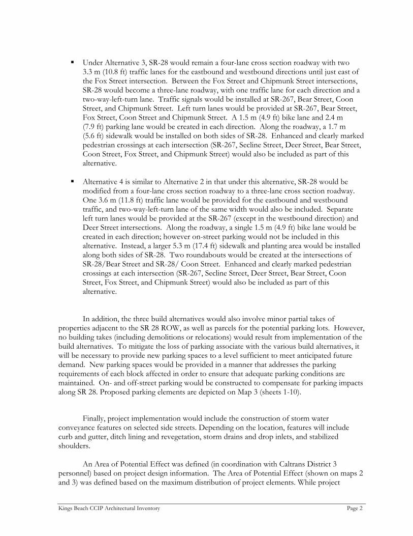
Under Alternative 3, SR-28 would remain a four-lane cross section roadway with two
3.3 m (10.8 ft) traffic lanes for the eastbound and westbound directions until just east of the Fox Street intersection. Between the Fox Street and Chipmunk Street intersections, SR-28 would become a three-lane roadway, with one traffic lane for each direction and a two-way-left-turn lane. Traffic signals would be installed at SR-267, Bear Street, Coon Street, and Chipmunk Street. Left turn lanes would be provided at SR-267, Bear Street, Fox Street, Coon Street and Chipmunk Street. A 1.5 m (4.9 ft) bike lane and 2.4 m (7.9 ft) parking lane would be created in each direction. Along the roadway, a 1.7 m (5.6 ft) sidewalk would be installed on both sides of SR-28. Enhanced and clearly marked pedestrian crossings at each intersection (SR-267, Secline Street, Deer Street, Bear Street, Coon Street, Fox Street, and Chipmunk Street) would also be included as part of this alternative.
Alternative 4 is similar to Alternative 2 in that under this alternative, SR-28 would be
modified from a four-lane cross section roadway to a three-lane cross section roadway. One 3.6 m (11.8 ft) traffic lane would be provided for the eastbound and westbound traffic, and two-way-left-turn lane of the same width would also be included. Separate left turn lanes would be provided at the SR-267 (except in the westbound direction) and Deer Street intersections. Along the roadway, a single 1.5 m (4.9 ft) bike lane would be created in each direction; however on-street parking would not be included in this alternative. Instead, a larger 5.3 m (17.4 ft) sidewalk and planting area would be installed along both sides of SR-28. Two roundabouts would be created at the intersections of SR-28/Bear Street and SR-28/ Coon Street. Enhanced and clearly marked pedestrian crossings at each intersection (SR-267, Secline Street, Deer Street, Bear Street, Coon Street, Fox Street, and Chipmunk Street) would also be included as part of this alternative.
In addition, the three build alternatives would also involve minor partial takes of properties adjacent to the SR 28 ROW, as well as parcels for the potential parking lots. However, no building takes (including demolitions or relocations) would result from implementation of the build alternatives. To mitigate the loss of parking associate with the various build alternatives, it will be necessary to provide new parking spaces to a level sufficient to meet anticipated future demand. New parking spaces would be provided in a manner that addresses the parking requirements of each block affected in order to ensure that adequate parking conditions are maintained. On- and off-street parking would be constructed to compensate for parking impacts along SR 28. Proposed parking elements are depicted on Map 3 (sheets 1-10).
Finally, project implementation would include the construction of storm water
conveyance features on selected side streets. Depending on the location, features will include curb and gutter, ditch lining and revegetation, storm drains and drop inlets, and stabilized shoulders.
An Area of Potential Effect was defined (in coordination with Caltrans District 3 personnel) based on project design information. The Area of Potential Effect (shown on maps 2 and 3) was defined based on the maximum distribution of project elements. While project
Kings Beach CCIP Architectural Inventory Page 2

Kings Beach Commercial Core Improvement Project 03-PLA-028PM 9.19-10.27 (KP 14.79-16.53)EA 03-OC9300
Map 1.Kings Beach CCIP Project Vicinity Map
SCALE
0 20 MILE10
0 20 KILOMETER10
Project Location
L O C A T I O N M A P
Project Location
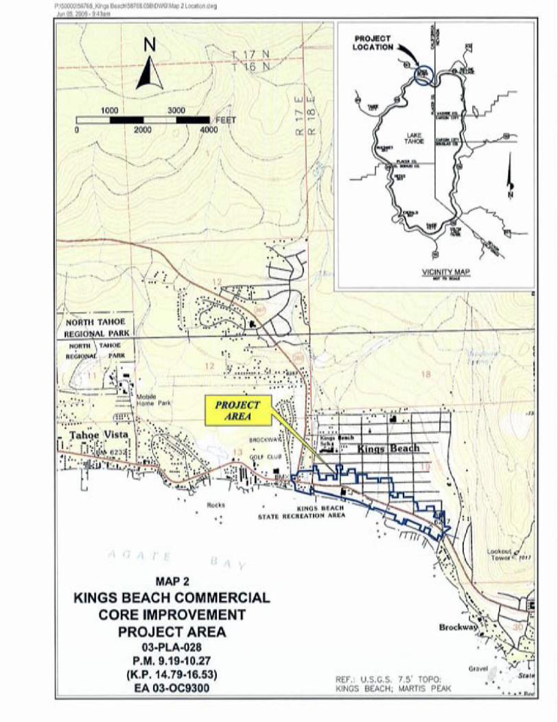

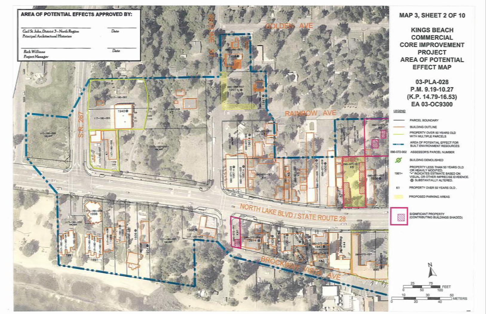
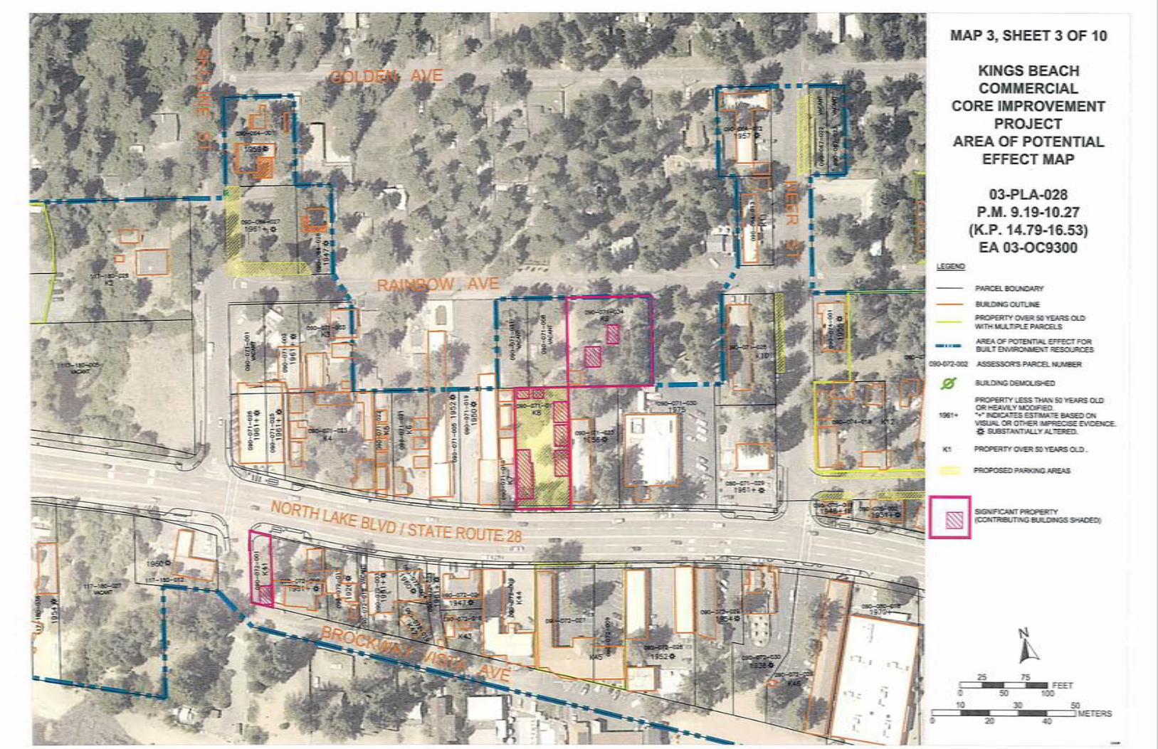


elements along the roadway corridor vary from one alternative to another, the location and type of elements located on the side streets remains fixed across all the alternatives. As a result, the outer limits of the APE are the same for all alternatives.
Project funding and/or approval will occur at several levels. Involved federal agencies will
include the Federal Highway Administration, the Army Corps of Engineers, and the Forest Service. Involved state agencies will include Caltrans, Regional Water Quality Control Board – Lahontan Region, California Tahoe Conservancy, and the Department of Fish and Game. Involved local agencies will include Placer County, the TRPA, and the North Tahoe Public Utility District. As a result, the project will need to comply with appropriate sections of the Programmatic Agreement Among the Federal Highway Administration, the Advisory Council on Historic Preservation, the California State Historic Preservation Officer, and the California Department of Transportation Regarding Compliance with Section 106 of the National Historic Preservation Act as it Pertains to the Administration of the Federal-Aid Highway Program in California (PA), sections of the California Environmental Quality Act dealing with historic resources, and Chapter 29 of the TRPA Code of Ordinances.
Geoarch Sciences, Inc., was retained by MACTEC Engineering and Consulting, Inc. to
identify and evaluate architectural resources within the project area. Mr. John W. Snyder, P.S. Preservation Services, served as the Principal Architectural Historian for the project. Dr. Ron Reno served as the Architectural Historian responsible for documenting and preparing the initial evaluation of architectural resources present in the project area. Mr. Charles D. Zeier served as project manager and assisted in report editing and preparation tasks. Others who assisted at the technical level included Ms. Elizabeth Bennett, Mr. Kirk Howell, Mr. Kurt Perkins, and Mr. Jeff Secord.
Client and agency copies of this report were produced on printers using paper and ink
listed by the National Park Service as meeting archival standards.
Kings Beach CCIP Architectural Inventory Page 3

2. RESEARCH METHODS
2.1 PRE-FIELD RESEARCH
Pre-field research for this study was tiered to research conducted on behalf of the project’s archaeological survey. Due to the number of resources recorded previously in the mountains surrounding Kings Beach (chiefly by Lindström [1993] and by Lindström and Waechter [1996]), research was limited to the area within 3/4 mile of proposed project elements. Sources consulted by the Information Center included National Register of Historic Places Listed Properties and Determinations of Eligibility, California Inventory of Historic Resources (1976), California Historical Landmarks (1996 and updates), California Points of Historical Interest (1992 and updates), Gold Districts of California (1979), California Gold Camps (1975), California Place Names (1969), Survey of Surveys (Historic and Architectural Resources) (1989), Directory of Properties in the Historical Resources Inventory (August 2000), Caltrans State and Local Bridge Surveys (2000), an archaeological overview by Toll and Elston (n.d.), an historic overview by Goodwin (1971), and Historic Spots in California (1966 and 1990).
The historic context presented in Section 2.2 is based on a literature search at the North Central Information Center of the California Historical Resources Information System, documents on file at the U. S. Forest Service Lake Tahoe Basin Management Unit Office, published historic and archaeological sources, maps and photographs at the Nevada Historical Society and at the University of Nevada Special Collections Library and Mines Library, aerial photos at the Nevada Bureau of Mines and Geology, and information kindly provided by Susan Lindström. A particularly useful resource was the Lenz photograph collection and historic maps housed at the Vista Gallery in Kings Beach. Photo collections at the North Lake Tahoe Historical Society were also investigated. Collections at the California State Library and at the Southern California Genealogical Society and Family Research Library were also utilized.
Results of the pre-field archival research are summarized in the archaeological survey report (Reno and Clay 2006). Emphasis here is placed on historical and architectural resources. Archival research revealed that one architectural inventory has been conducted within the archival study area. This inventory (Caltrans 2004) reviewed architectural resources located along SR 28 from Tahoe City to the Nevada state line, exclusive of Kings Beach. Further, no National Register sites, state landmarks, historic districts, or listed properties have been previously recognized in the study area. There are no listings of any buildings in Kings Beach in the California Determinations of Eligibility directory.
The Placer County Assessor’s Office provided detailed information for all parcels in the
project area, including use, owner names and addresses, site addresses, year built, and effective year. In some cases, building permit files were inspected. This information was supplemented by a visit to the Placer County Recorder’s Office to search for subdivision maps and to inspect copies of historic highway planning maps. Mr. Dan LaPlante of the Placer County Department of Public Works was most helpful, assisting in all these efforts.
Kings Beach CCIP Architectural Inventory Page 4

In addition to the many property owners who provided information about their buildings, several residents provided information about the community at large. They included Mr. Jack Felte, Ms. Katherine Felte, Ms. Mary Panelli, Mr. Leon Schegg, Mr. Douglas Taylor, Mr. John Wainscoat, and Ms. Julie Wainscoat. Their willingness to do so is gratefully acknowledged.
2.2 HISTORICAL OVERVIEW
Early emigrant trails did not enter the project area, they passed around the southern end of Lake Tahoe and over Donner Summit to the north. The major wagon supply route from California to the Comstock also passed to the south. A less popular route did pass through the project area. Scott’s Route (Placer County Emigrant Road), used for only a short time (1852 to 1855) passed along the north shore of Lake Tahoe (Lindström 1993). In 1869, George Schaffer and William Campbell built the Truckee-Brockway Road, or Brockway Cutoff. This road also passed through the study area. In 1874, a linking road was constructed along the north shore of Lake Tahoe. This road was an improvement of the old Scott Route and closely approximated the route of current day State Route 28 (Goodwin 1971:12). These roads are shown on historic maps (e.g., von Leicht and Hoffman 1874; Wheeler Survey 1877a, 1877b, 1877c).
The tiny settlement of Pine Grove Station was located at the intersection of the road
along the north shore and the Truckee-Brockway Road. The 1865 township survey map shows a house next to the beach (along the township boundary) and another house located along the road to Brockway, just within the east boundary of the project area. That map identifies the occupant of the station (the western most house) as D. H. Wright. This settlement is identified by the single name “Griffin” on two of the Wheeler maps (1877a, 1877c).
The area was not a stopping point for major steamer traffic in the late nineteenth or early
twentieth centuries. A steamer-based resort trade never developed here. Throughout this time period, people passed through the area on their way to other destinations, particularly the hot springs resort at Brockway. Elements of the Brockway hot springs complex show up on most maps about 1/4 mile southeast of the project area. According to Scott (1957:331):
At the intersection of the present Tahoe-Truckee-Martis Valley road, where it joins the lake road on Griff’s Creek, originally stood Wiggins’ Station. Built in 1864 by wood contractor George W. Wiggins, it became known as the ‘logger’s headquarters’ and by the year 1872 it had been taken over by John Griffin, a well-educated lumberman from the Truckee Basin who cut saw logs and cordwood on the mountainous slope of north Lake Tahoe.
This complex included a log cabin on the road, corrals, and an array of small cabins that
served as workers’ housing. Meadows in the area were enhanced with small-scale irrigation works and used for summer grazing and haying. In the early 1920s, a sandy beach area was developed as a golf course (Scott 1973:137).
During the early 1920s, settlement in the study area was sufficiently sparse that it did not
warrant note or a place name on maps (U.S. Coast and Geodetic Survey 1923; U.S. Forest Service 1926). This was the end of a long period of economic stagnation for the Tahoe Basin, following
Kings Beach CCIP Architectural Inventory Page 5

the demise of industrial-scale logging operations. This was due to change, as noted by Jackson and Pisani (1973:1):
A case can be made for 1924 as the year in which the modern, or contemporary, history of Lake Tahoe began. At that time there was only a small community at the south shore and scattered clusters of home sites and resorts along the north and west shores. The handful of year-round residents were snowbound in the basin from November to June each year; only in the summer months did a few hardy campers and summer home owners venture over the tortuous roads to the Lake. Tahoe’s modern development awaited dependable automobiles, construction of a good, all-weather highway, and entrepreneurs who saw the potential for turning the Lake into an all-year tourist playground.
It was somewhere between 1923 and 1925 that Joe King started to obtain control of the
commercial core of Kings Beach from Robert P. Sherman (Sherman, along with Harry O. Comstock controlled interests in land throughout what is now Tahoe Vista, Kings Beach, and Brockway – interests formerly consolidated by Frank Brockway Alverson in the 1890s). Sherman constructed the Buckhorn Inn, the first modern commercial building in Kings Beach, which continued to be used into the 1950s.
During the 1920s, some of the earliest subdivisions in the Lake Tahoe basin were
established along the north shore. During this time Sherman family members were involved in refining the subdivision concept elsewhere in California. Robert was the adopted son of “General” Moses H. Sherman (the developer acquired the title by serving as adjutant-general of Arizona Territory), who was instrumental in early urban development in Phoenix and was the key developer of Sherman Oaks near Los Angeles. Much more important than his Lake Tahoe connection, Robert was a vice president for the M. H. Sherman Investment Company, based in Los Angeles (American Historical Society 1921; Dahlstrom 1971; Lindström 2001; Los Angeles Directory Co. 1916; Scott 1957:333, 1973:139; Sherman 1991; Spalding 1931).1
Much of the street and property layout of Kings Beach and adjacent Tahoe Vista dates
from the 1920s. Individual subdivisions, characterized by restrictive covenants, conditions, and restrictions, included Cala-Neva in 1914, Wood Vista or Woodmere in 1924, Brockway Vista in 1924 (which includes most of the project area), and Brockway Vista Addition in 1926 (Lindström and Waechter 1996:59). Lots were quite small (only 25 feet wide, locally called “slices”) since they were intended primarily as seasonal automobile campsites that would support no more than a small cabin. These and other developments gradually merged to make a nearly unbroken, dispersed, residential pattern from Tahoe Vista through Kings Beach to Brockway. By 1940 the modern quadrangular road system, defined by subdivisions begun in the late 1920s, was well established in Kings Beach, as shown on U. S. Geological Survey maps. Aerial photos of the era show that, although established, many of the roads were nearly unused.
1 As luck would have it, General William Tecumseh Sherman was also active in California and had
a nephew named Robert T. Sherman. Neither had anything to do with Kings Beach, but the coincidence has given this more famous Sherman family a firm place in the local folklore as founders of the community – for example on the web page for the “Historic Old Brockway Golf Course” (Old Brockway Golf Course 2003; Sacramento Union 1/19/41 p. 14; TSHA Online 2003).
Kings Beach CCIP Architectural Inventory Page 6

Beginning in the 1920s, a row of small businesses began to be established along State
Route 28. Catering to a more middle-class, automobile-based group of tourists, many were constructed and leased out by the King family. This strongly linear commercial corridor was surrounded and partly permeated by a largely seasonal, residential neighborhood that included single-family residences, multi-family residences, rental cabins, and motels. By this time, the forest was recovering from nineteenth century logging and many parcels were close to one of the finest sand beaches at Lake Tahoe. An additional attraction was, and continues to be, the Brockway golf course at the west end of Kings Beach. The community soon became known as “Lake Tahoe’s Coney Island.”
Plans for improving State Route 28 (North Lake Boulevard) prepared by the California
Division of Highways in 1936 show in detail all of the buildings then present on lots facing the main road (and in some cases also show buildings and additional lots away from the highway). Those plans show that driveways often ignored parcel lines, cutting across vacant lots as convenient points. Since the Brockway Vista Subdivision blocks and lots are also depicted on the map, it is possible to identify specific historic buildings. A scatter of houses and outbuildings is present along the entire length of the project area. At that time, the commercial core of town was strictly limited to the block between Coon and Bear Streets. Most buildings are on the south side of the street, including King’s cottage complexes, the Buckhorn Inn, two restaurants, and a real estate office. Businesses on the north side of the street included a waffle shop, store, and an automobile service station (Highway Department 1936).
During the early years, the transportation system around the lake was severely affected by winter weather. It was only with the legalization of gaming on the Nevada side of the lake, related increases in automobile touring, and expansion of winter sports that roads were routinely cleared of snow. The resulting year-round income helped small businesses in Kings Beach to become established and survive. An anonymous 1939 tourist map of Tahoe featured an advertisement for “Nelson’s Garage and Cottages” with Shell products, cabins, and affiliation with the National Auto Club. Paine’s Mercantile is also featured on this map. Both of these establishments pointed out that they remained open year round.
By the late 1930s to early 1940s the commercial part of town had been further developed on the south side of the highway (just east of Bear Street) to include a large mercantile store, a drug store, a movie house, and a modern style Chevron Station. The eastern third of the block west of Bear Street on the northern side of the highway included a café, a photo studio, and a traditional-design service station. This marked the western extent of the commercial district, except for a small barbecue stand near Deer Street (Hayden 1939). The commercial district expanded eastward to Chipmunk Street, including a bakery, motels, and possibly a theatre. During this period, a fire station was built near the intersection of North Lake Boulevard with the Brockway Grade (State Route 267).
Throughout the Tahoe Basin, little new development occurred during the Second World War (Jackson and Pisani 1973). Early post-war development is well documented by phone book listings (PT&T 1952). Several new motels, many of them two stories tall, were built along North Lake Boulevard. These supplemented, but did not replace, the many resort cottages present in Kings Beach. A newer and more transient tourist was being catered to, often staying for a night or a weekend rather than for a week or a month. As before, other businesses directly or
Kings Beach CCIP Architectural Inventory Page 7

indirectly supported tourism. They included boat rentals, markets, bakeries, automobile services stations, bars, beauty salons, theatres, and restaurants. The Kings Beach area was advertised as a fine place to stay, one that had the advantages of natural beauty and proximity to legalized gaming at Crystal Bay. Presiding over the center of the community was the new two-story brick post office building.
Between 1953 and 1960 the character of the commercial corridor through Kings Beach had stabilized, while residential growth continued to fill in most of the surrounding subdivision parcels. The urban corridor was more impressive than it is today, with an almost continuous row of businesses from Secline Street all the way to Chipmunk Street (CSAA 1956; PT&T 1953, 1954, 1955, 1956). This streetscape was altered in the 1970s when land on the lakeside of the street was acquired to create the King’s Beach State Recreation Area. This resulted in the removal of a number of buildings on that side of the street.
The onset of modern development at Kings Beach was sparked by selection of nearby Squaw Valley as the location for the 1960 winter Olympic games. This represented a change in focus from fairly small resorts of the 1930s to huge complexes drawing patrons of winter sports from across the world. Many buildings present in the community today were constructed or remodeled to support crowds attending the games. ARCHITECTURAL PERIODS
From this narrative, it is possible to derive four major periods associated with the architectural development of Kings Beach: 1860-1924: Early Settlement 1925-1945: Subdivision and Commercial Development 1946-1960: Postwar Expansion 1961-present: Modern Development and Redevelopment
Due to low population levels and the extent of subsequent development, resources dating
to the first period are expected to be rare. If located, they are likely to be significant even if their integrity has been compromised. Period 2 is the principal period of architectural significance at Kings Beach, reflecting the formative years of business and residential development. Because they are more common, only those buildings associated with Period 3 with special characteristics or associations are likely to be architecturally significant. Most properties associated with the fourth period are less than 50 years in age and were not formally recorded. None of the buildings in the project area that date to this period exhibit exceptional characteristics or associations required for such a recent property to be eligible for the National Register.
2.3. ARCHITECTURAL CONTEXT
Use of the Lake Tahoe Basin as a tourist destination and place for seasonal residences resulted in buildings ranging from large casinos and hotels to tiny rustic cabins. Regardless of the scale, the primacy of nature runs through much of the literature on Tahoe architecture. According to many accounts, there is a distinct Lake Tahoe Style of architecture. Although not a
Kings Beach CCIP Architectural Inventory Page 8

recognized style, it and related styles have been the subject of intense debate. Some scholars discuss various influences on the rustic architecture constructed at Lake Tahoe. Others have taken a wider view, investigating broader patterns of rustic or mountain architecture. John Deering (1986) has written extensively about what he calls Mountain Architecture common to alpine settings throughout the United States and parts of Europe. San Francisco architect Theodore Brown, as quoted in Tahoe Daily Tribune April 28, 2004, prefers the evocative term Mountain Expression. Architectural historian John Snyder’s use of the term Rustic Architectural Ethic similarly focuses on an aspect of architecture that transcends the typological issues of style (P.S. Preservation Services 2001:11). In their study of Rustic Architecture for the National Park Service, Tweed, Soulliere, and Law (1977:1) lament the limitations of the term, but note its long-term usage and lack of a reasonable alternative, “A superior term has never appeared, so ‘rustic’ it remains.” Despite its limitations, the term Lake Tahoe Style is sufficiently recognizable that it serves to market particular house designs regardless of setting (Johnson 2004).
Outstanding high-style examples at the lake by architects including Bernard Maybeck,
Gordon Kaufmann, and Frederick DeLongchamps, are Fleischmann’s estate and Whittell’s Thunderbird Lodge with their emulation of northern European vernacular and British Arts and Crafts design elements, the Knight’s Vikingsholm estate with its emulation of Scandinavian design, and the Ehrman estate with echoes of both the British Arts and Crafts and Chateau traditions (James and James 2002; Marvin et al. 2003; Reno 2004b).
Large homes built at Lake Tahoe during the early years of the twentieth century embodied the Rustic style. Examples listed on the National Register are the Hellman/Ehrman Estate (1894), the Heller Estate (1924), and the home of “Lucky” Baldwin’s daughter, Dextra (1923-24), at Tallac. The Hellman/Ehrman Estate, built on the site of the former Bellevue luxury hotel, was the summer home of wealthy San Francisco financier Isaias W. Hellman. While it was a sumptuous home, and was not constructed of log, the huge posts supporting the long porch were unpeeled (bark-clad) logs with set-in unpeeled log shoulders. Other structures on the property have more rustic qualities than the main house. Also on the property is the Phipps log cabin, the home of the first settler to the area, who homesteaded in 1872 (Welts n.d.).
The three estates at Tallac (the Pope, Heller, and Baldwin Estates) are also characterized by degrees of rusticity, from sophisticated rustication to romanticized bark and log structures. Again, on the main houses large posts supporting porches are typically peeled or unpeeled logs. Dextra Baldwin used half logs for her home and full log construction for her guest cabins. The other estates employed log construction mainly for outbuildings. The boat house on the Heller Estate is cedar bark laid up vertically, while the “Honeymoon cottage” on the Pope Estate is log, with curvilinear branches decoratively filling the gables over the porch. The latter structure, especially, epitomizes the romance of log construction (Boghosian et al. n.d.).
The famous Nevada architect, Frederick DeLongchamps, designed several homes at Lake Tahoe in the Rustic style, including one for Senator (former Governor) Tasker Oddie in 1932 that had many of the same features as those found in Zephyr Cove and at Kings Beach. They included the use of unpeeled boards, grouped casement windows, and picture windows. In 1935, he designed a two-story home at Lake Tahoe for O. Alexander in the same style that featured cedar bark siding and a verandah with log railings.
Kings Beach CCIP Architectural Inventory Page 9

In recent decades, architectural recording has been broadened from the high-styles mentioned above to vernacular expressions of the same general ideals. Nearly all of the rustic architecture of Kings Beach is decidedly vernacular, characterized by small scale and use of relatively inexpensive wood trim, such as siding shaped to look like logs, wood and bark shingles, and exposed rafters. True log construction is rare, as is the magnificent stonework often present in high-style examples. Natural finishes, such as oil, are preferred to paint. Gable, hip, and gambrel roofs tend to be moderate to steeply pitched, but can be low pitched on small buildings. Dormers are common. From this period, most Tahoe buildings do not exceed 1½ stories and basements are rare. Similar simple expressions of rustic log and stone architecture are present in the Zephyr Cove Properties Historic District (P.S. Preservation Services 2001) and at Tahoe Meadows. Tahoe Meadows, an early vacation home subdivision in South Lake Tahoe, was subdivided in 1924 and incorporated in 1925, making it contemporary with the Brockway Vista Subdivision at Kings Beach. The modest homes and cabins built in this subdivision were generally rustic, and often of log. Bernard Maybeck, one of California’s most famous architects, designed two of the cottages (Woodbridge n.d.).
The appropriateness and popularity of rustic architecture was and continues to be recognized at Lake Tahoe. The local Tahoe Tattler newspaper routinely carried articles about new construction in the 1930s that showed an overwhelming preference for this style (e.g. August 30, 1935 pp. 1-2; August 26, 1938 pp. 1-4; August 18, 1939 pp. 1,4). The style was repeatedly called “Tahoe-type architecture” in these articles. It was not only the popular press, but architects as well that recognized the distinctive regional character of resort rustic architecture at Tahoe.
For purposes of this project, well-preserved examples of a common style (such as Craftsman or Minimal Traditional) are not considered significant. To be significant a building must retain characteristics that make it an outstanding example of a particular form of rusticity that would be recognized locally as “Lake Tahoe Style.” Also required is a setting that is sufficiently intact that the building retains the somewhat ethereal qualities of feeling and association. For the purposes of this report and associated DPR forms, the more widely inclusive term “Mountain Rustic” or simply “Rustic” is used to describe these various characteristics used to modify recognized architectural styles to fit into the local setting.
In most cases, buildings eligible for the National Register or the California Register are
outstanding or particularly representative examples of the range of buildings that reflect the amorphous concept of Lake Tahoe Rustic architecture. In 1990 Alpengroup evaluated the status of many historic buildings in the Tahoe Basin and made some observations pertinent to the later development of Kings Beach:
The Basin is confined by the Lake and the mountains and therefore the options available for both public and private development is severely limited. Some of the best development sites in the Basin are the already built sites. Often a larger residence is built on the site of a smaller and older house. Much of the early twentieth century residential development was modest. Small cabins and cottages were built as vacation homes. These buildings are threatened with replacement as more houses become year round first and second homes and as the current size requirements of both are much higher now than they were forty, fifty, and sixty years ago.
Kings Beach CCIP Architectural Inventory Page 10

Many of the people building in the Basin today are not from the Basin and have very little sense of the history of the area. Without knowledge of the area’s history or an appreciation for what is appropriate to the historic areas, the architects, builders, developers, and owners are not designing and building sensitive and appropriate structures (Alpengroup 1990:37-38). Other styles present in small numbers include International, Streamlined Moderne, and
A-frames. Numerous permanently occupied travel trailers are present in several parks. The most common residential style for the periods of significance is Minimal Traditional, often merging into Ranch Style (McAlester and McAlester 1990:478). A common resource type is the motel. Detached Row, Row-on-Row, L, and U configured cottage courts are present. One and two-story integrated motor courts are laid out in Row and L forms (Jakle 1996:37). IS A HISTORIC DISTRICT PRESENT?
A decision that had to be made was whether to record buildings in Kings Beach as part of a district or as individual buildings. In favor of district recording is the fact that the project area was platted as the Brockway Vista Subdivision in 1926 (Subdivision Plat D16A), and that all of the surviving buildings are oriented on subdivision lots. Due to its early date, the subdivision itself might be significance as an example of the first generation of subdivisions around Lake Tahoe, and also is potentially significance due to its association with an individual (Sherman) who was highly important in spreading the subdivision concept elsewhere.
The problem with recording Kings Beach as a district is its general lack of integrity. Most
1920 to 1930 buildings in the commercial core were removed to make way for the State Park. This demolition included most of the buildings owned by subdivision founder Joe King. Many of the remaining older businesses and residences have been extensively modified or demolished. As a result, only 63 of the 171 properties in the project area, which covers all of the commercial center of Kings Beach and a sample of the residential back streets, are old enough and retain enough character to warrant detailed recording. Of the 63, only 6 appear to meet National Register and California Register criteria for significance. These buildings are not concentrated into small blocks or neighborhoods. Rather, they are scattered throughout the inventoried area.
Generally, well over half of the buildings within a district must be significant contributing
resources for the district as a whole to be considered significant. Based on the numbers provided above, Kings Beach does not meet this criterion. As a result, there is little justification for regarding Kings Beach as a significant historic district. Therefore, district-level recording of Kings Beach was not done. Instead, buildings were evaluated on their own merits when viewed within the context of architectural development in the Tahoe Basin. To a lesser extent, they were evaluated in relation to specific aspects of the development of Kings Beach.
Kings Beach CCIP Architectural Inventory Page 11

3. FIELD METHODS
A preliminary reconnaissance of the project area was conducted in 2001 during fieldwork for an archaeological survey of the project area. At that time it was noted that numerous buildings were present that were historic in age. This resulted in a determination that an architectural survey would be necessary. An Area of Potential Effect was defined (in coordination with Caltrans District 3 personnel) based on project design information. The Area of Potential Effect (shown on maps 2 and 3) was defined based on the maximum distribution of project elements. While project elements along the roadway corridor vary from one alternative to another, the location and type of elements located on the side streets remains fixed across all the alternatives. As a result, the outer limits of the APE are the same for all alternatives. The proposed project will be complete by the end of 2010. As a result, only those buildings and structures built in or before 1960 were included in the study. Fieldwork occurred between November 2002 and January 2003. All buildings and structures present within the Area of Potential Effect were photographed. Assessor’s Office data were collected regarding the street address, legal owner (and address), year of construction, and average year of construction. Supplemental recording was required due to project boundary modifications and the steady accumulation of detailed contextual material. This work occurred during the early months of 2005. Dr. Ron Reno oversaw all field activities. He compiled information about each of the buildings and took photographs. Ms. Elizabeth Bennett, Mr. Kurt Perkins, and Mr. Charles Zeier assisted Dr. Reno, preparing site maps and maintaining photo logs. Property owners encountered during the inventory were asked about the history of their property and nearby parcels, and some follow-up interviews were conducted. Results of fieldwork are recorded on Department of Parks and Recreation DPR 523 forms prepared in accordance with Department guidance. These forms consist of a primary record; a building, structure and object record (BSO); and, as necessary, continuation sheets. These records are provided in Appendix A.
Two problems affected field efforts. Several map sources had to be used concurrently to identify which buildings were associated with particular parcels. In the field, it was necessary to work simultaneously with assessor’s parcel maps, air photos and detailed maps enhanced with building footprints and parcel boundaries, information from landowners, and the placement of the buildings and fence lines themselves. Typically, sources did not agreed entirely, requiring a melding or synthesis of information taken from various sources. This was accomplished on a parcel-by-parcel basis. Results of this exercise are provided on sketch maps provided on the BSO forms and the building and parcel outlines shown on Map 3.
The second problem dealt with dates. The assessor’s office provided printouts that contained the “year built.” A list was compiled of older buildings. Initial field efforts relied on this list. It soon became apparent, however, that many older buildings were not included on the list. A follow-up query produced information regarding the “effective year” of construction on each parcel. This is an average date that theoretically reflects changes made to the property. This information helped in some cases, confirming that many of the suspicious buildings were indeed historic. In many cases, however, the assessor’s database lacks construction dates of any sort.
Kings Beach CCIP Architectural Inventory Page 12
Ultimately, the decision as to which buildings should be recorded was based on all of the historic sources consulted, along with information from informants, and physical characteristics of the buildings. At present, few of the dates obtained should be considered absolute construction dates. Rather, available dating indicates that a building is at least as old as the date detailed on the BSO record, but may have been constructed somewhat earlier.
Private residences were recorded from the street, while commercial properties were examined from parking lots and driveways. No interiors were examined as a part of this survey.
Photographs were taken of all recorded buildings (see individual forms contained in Appendix A). In some cases, photography was hampered by the presence of trees or cars, the location of the building at the back of the lot, or due to the presence of other buildings. In many cases, overview photographs were not obtainable. To a large degree, problems associated with photographing the buildings were reduced by supplemental visits to the project area. Emphasis was placed on visiting the area on overcast fall or winter days. This reduced the effect of tree shadows and improved visibility due to the reduced number of cars and the reduced mass of deciduous vegetation.
A sequence of map reference numbers (K1, K2, etc.) was assigned to all properties older than 1961 (up to and including 1960), proceeding from west to east on the north side of North Lake Boulevard, then from west to east on the south side of North Lake Boulevard. For properties consisting of multiple parcels, a single map reference number was assigned regardless of how individual buildings might fall regarding assessor’s parcels. Finally, for properties with several buildings, each building (excluding outbuildings such as sheds and garages) was assigned a letter designation.
Kings Beach CCIP Architectural Inventory Page 13

4. DESCRIPTION OF CULTURAL RESOURCES
A dramatic event in Kings Beach was construction of the new red brick post office building (known as the King Building) in 1948. This building, with its strongly horizontal International styling, marks the start of the transition of the commercial core. The post office joined Art Deco and International Style service stations of the 1930s that replaced earlier stations designed as Traditional Style buildings with gas pumps by the streets. Modern and eclectic styling has typified construction along North Lake Boulevard at an increasing pace from the 1940s to present. This has created an architectural rift between commercial buildings and other buildings along back streets that through the 1950s continued to favor rustic styling. This tension between rustic and modern styles is evident in many places in Kings Beach and is in no way resolved. In the case of the Lenz Building, the elaborate rustic peeled “log and branch” accent pieces have been eliminated and enclosed as more shop space. Going the other direction, the thoroughly modern Ta-Tel Motel was extensively modified to create a rustic effect through addition of cobble planter walls, unpainted T1-11 siding (an inexpensive way to emulate the general look of board siding), and peeled log accents and railings. This motel is an example of a trend along main street toward alterations or new construction that evokes rustic architecture, but is not uniformly applied.
In addition to the many single family residences that favored rustic details, Kings Beach, in common with many areas with good road access around Lake Tahoe, saw development of numerous resort cabin complexes characterized by a larger house occupied by the owner/manager and family and varying numbers of cabins generally arrayed around a central courtyard often used as a parking lot. Several such complexes survive in Kings Beach. They are found both on the main street and on back streets, and almost universally have switched in use from vacation tourism rentals to long-term, low-income housing.
Detailed information about individual built environment resources is in the attached DPR 523 forms. Following are brief descriptions of resources that appear to be eligible for the National Register: K8, Blair’s Cottages: This property includes an office/residence, two duplex units, and
three single units arrayed around a central courtyard/parking lot. It is a small cottage court that fits into its wooded setting due to massing. The rustic effect of the cabins is enhanced by use of log cabin siding.
K9, Fuhrmann Houses: This property includes two gambrel-roofed residences and a
large shed on a wooded lot. The residences are of simple Vernacular design, and fit into their wooded setting due to massing and use of unpainted V-rustic siding.
K18, Blue Lagoon Café: This property is a 2½-story rectangular plan wood frame
commercial building with a jerkin-head roof. Originally a building from a sawmill complex, it was modified into a café following its move to Kings Beach where shingle siding, plate glass windows, and small wood sash windows were added within the period of significance.
Kings Beach CCIP Architectural Inventory Page 14

K41, Lanini House: This property is a small rustic cabin. Its gabled roof is extended to form a covered porch overlooking Lake Tahoe. Walls are covered with log cabin siding. This building has more rustic elements than any other observed in Kings Beach, including pole roof rafters and use of log cabin siding on the underside of the porch roof.
K49, Welch Houses: This property includes two small gable residences and a detached
garage. Their simple Minimal Traditional style is effectively enhanced to fit the wooded lot by use of cedar bark shingle, unpeeled log cabin, milled log cabin, and stained V-rustic siding along with unpeeled cedar bark corner boards.
K56, Evergreen Lodge: This property is a two-story motel. Its Minimal Traditional form
is effectively clad with stained log cabin siding to fit into its wooded setting.
Kings Beach CCIP Architectural Inventory Page 15

5. FINDINGS AND CONCLUSIONS
5.1 FINDINGS
The Area of Potential Effect for the proposed project includes an area sufficient to incorporate the construction footprint of all proposed project alternatives. Archival research revealed that no National Register listed historic properties are present within the Area of Potential Effect.
The Area of Potential Effect for the proposed project contains 171 improved parcels.
Mr. John Snyder, who meets the Professionally Qualified Staff Standards in Attachment 1 of the PA as an Architectural Historian, has determined that 108 of those parcels, including state-owned resources, contain buildings that meet criteria identified in Attachment 4 of the PA. As a result, those 108 parcels were exempted from evaluation.
One parcel has been recorded previously and buildings present were determined ineligible
for listing on the National Register and are not historical resources as that term is applied under CEQA or the TRPA Code of Ordinances (Table 1).
Table 1. Properties Previously Determined Ineligible
Name Address/Location Community OHP Status
Code Map
Ref. # Brockway Pines Motel 8796 Brockway Vista Ave. Kings Beach, CA 6Z K63
The remaining 62 parcels were formally recorded and evaluated using State of California
Department of Parks and Recreation DPR 523 historical resource inventory forms. Of those parcels, six contained resources that appear eligible for inclusion in the National Register and qualify as historical resources based on CEQA and TRPA criteria (Table 2). The remaining 56 appear not to be eligible for inclusion in the National Register and do not qualify as historical resources based on CEQA or TRPA criteria (Table 3).
Table 2. Properties That Appear to be National Register Eligible
Name Address/Location Community OHP Status
Code Map
Ref. # Blair’s Cottages 8199 N Lake Blvd. Kings Beach, CA 3S K8 Fuhrmann Houses 8220 and 8230 Rainbow Ave. Kings Beach, CA 3S K9 Blue Lagoon Cafe 8399 N Lake Blvd. Kings Beach, CA 3S K18 Lanini House 8080 N Lake Blvd. Kings Beach, CA 3S K41 Welch Houses 8659 Brockway Vista Ave. Kings Beach, CA 3S K49 Evergreen Lodge 8720 N Lake Blvd. Kings Beach, CA 3S K56
Kings Beach CCIP Architectural Inventory Page 16

Table 3. Properties That Appear Not to be National Register Eligible
Name Address/Location Community OHP Status
Code Map
Ref. # Stones County Tire 8001 N Lake Blvd. Kings Beach, CA 6Z K1 Kings Beach Library 301 Secline St. Kings Beach, CA 6Z K2 Torres Apartments 8094 Rainbow Ave. Kings Beach, CA 6Z K3 Little Bear Cottages 8095 N Lake Blvd. Kings Beach, CA 6Z K4 La Comunidad Unida 8111 N Lake Blvd. Kings Beach, CA 6Z K5 Caesar’s Motel 8123 N Lake Blvd. Kings Beach, CA 6Z K6 Habeger Houses 8173 N Lake Blvd. Kings Beach, CA 6Z K7 Anderson House 265 Deer St. Kings Beach, CA 6Z K10 Hurtando Apartments 325 Deer St. Kings Beach, CA 6Z K11 Benning’s Resort 8315 Trout Ave. Kings Beach, CA 6Z K12 Jameson Houses 8333 Rainbow Ave. Kings Beach, CA 6Z K13 Henderson House 8363 Rainbow Ave. Kings Beach, CA 6Z K14 Franklyn Lee House 8368 Rainbow Ave. Kings Beach, CA 6Z K15 Lake Air Resort 265 Bear St.
8385 Trout Ave. Kings Beach, CA 6Z K16
Lofstead Houses 8358 Trout Ave. Kings Beach, CA 6Z K17 Glad-Lee Lodge 268 Bear St. Kings Beach, CA 6Z K19 Northwood Pines Motel 8489 Trout Ave. Kings Beach, CA 6Z K20 Kalange Apartments 8448 Trout Ave. Kings Beach, CA 6Z K21 La Mexicana Meat Market 8515 Brook Ave. Kings Beach, CA 6Z K22 Duzevich House 8534 Trout Ave. Kings Beach, CA 6Z K23 Going House 8550 Trout Ave. Kings Beach, CA 6Z K24 C. Smith Apartments 8537 Brook Ave. Kings Beach, CA 6Z K25 Old Post Office 8401 N Lake Blvd. Kings Beach, CA 6Z K26 Bruening Realty 8470 Brook Ave. Kings Beach, CA 6Z K27 Alpine Club /Tradewinds 8545 N Lake Blvd. Kings Beach, CA 6Z K28 Brevid House 241 Coon Street Kings Beach, CA 6Z K29 R. Barber Houses 8673 Salmon Ave. Kings Beach, CA 6Z K30 Schneider House 8679 Salmon Ave. Kings Beach, CA 6Z K31 S. Smith Buildings 8675 N Lake Blvd. Kings Beach, CA 6Z K32 Miniature Golf 8681 N Lake Blvd. Kings Beach, CA 6Z K33 S. Smith Apts 8684 Salmon Ave. Kings Beach, CA 6Z K34 C. Smith House 8771 N Lake Blvd. Kings Beach, CA 6Z K35 Tacos Jalisco 8717 N Lake Blvd Kings Beach, CA 6Z K36 Miller House 8789 Minnow Ave. Kings Beach, CA 6Z K37 Shoberg House 8827 Minnow Ave. Kings Beach, CA 6Z K38 Blue Waters Lodge 221 Chipmunk St. Kings Beach, CA 6Z K39 Gifford House 8817 N Lake Blvd. Kings Beach, CA 6Z K40 Eriksson House 8129 Brockway Vista Ave. Kings Beach, CA 6Z K42 Rasch House 8317 Rainbow Ave. Kings Beach, CA 6Z K43 Gold Crest Motel 8194 N Lake Blvd. Kings Beach, CA 6Z K44 Crown Motel 8200, 8226 N Lake Blvd. Kings Beach, CA 6Z K45 Sun ‘N Sand Motel 8308 N Lake Blvd. Kings Beach, CA 6Z K46 Mr. Video 8612 N Lake Blvd. Kings Beach, CA 6Z K47 Lakeside Gallery & Gifts 8636 N Lake Blvd. Kings Beach, CA 6Z K48 Dentraygues House 8680 N Lake Blvd. Kings Beach, CA 6Z K51 Rockwood Houses 8669 Brockway Vista Ave. Kings Beach, CA 6Z K50 Duggan Houses
8675, 8677, and 8679 Brockway Vista Ave.
Kings Beach, CA 6Z K52
Kings Beach CCIP Architectural Inventory Page 17
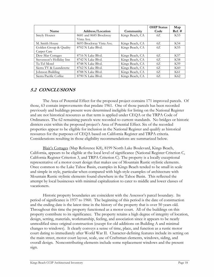
Name Address/Location Community OHP Status
Code Map
Ref. # Smyly Houses 8681 and 8685 Brockway
Vista Ave. Kings Beach, CA 6Z K53
M. Smith House 8693 Brockway Vista Ave. Kings Beach, CA 6Z K54 Golden Group & Quality Carpet Care
8702 N Lake Blvd. Kings Beach, CA 6Z K55
Dew-Mar Cottages 8716 N Lake Blvd. Kings Beach, CA 6Z K57 Stevenson’s Holliday Inn 8742 N Lake Blvd. Kings Beach, CA 6Z K58 Ta-Tel Motel 8748 N Lake Blvd. Kings Beach, CA 6Z K59 Sierra TV & Launderette 8762 N Lake Blvd. Kings Beach, CA 6Z K60 Johnson Building 8788 N Lake Blvd. Kings Beach, CA 6Z K61 Sierra Pacific Coffee 8790 N Lake Blvd. Kings Beach, CA 6Z K62
5.2 CONCLUSIONS
The Area of Potential Effect for the proposed project contains 171 improved parcels. Of those, 63 contain improvements that predate 1961. One of those parcels has been recorded previously and buildings present were determined ineligible for listing on the National Register and are not historical resources as that term is applied under CEQA or the TRPA Code of Ordinances. The 62 remaining parcels were recorded to current standards. No bridges or historic districts exist within the proposed project’s Area of Potential Effect. Six of the recorded properties appear to be eligible for inclusion in the National Register and qualify as historical resources for the purposes of CEQA based on California Register and TRPA criteria. Considerations resulting in those eligibility recommendations are summarized below.
Blair’s Cottages (Map Reference K8), 8199 North Lake Boulevard, Kings Beach, California, appears to be eligible at the local level of significance (National Register Criterion C, California Register Criterion 3, and TRPA Criterion C). The property is a locally exceptional representative of a motor court design that makes use of Mountain Rustic stylistic elements. Once common to the Lake Tahoe Basin, examples in Kings Beach tended to be small in scale and simple in style, particular when compared with high-style examples of architecture with Mountain Rustic stylistic elements found elsewhere in the Tahoe Basin. This reflected the attempt by local businesses with minimal capitalization to cater to middle and lower classes of vacationers.
Historic property boundaries are coincident with the Assessor’s parcel boundary. Its period of significance is 1937 to 1960. The beginning of this period is the date of construction and the ending date is the latest time in the history of the property that is over 50 years old. Throughout this time the property functioned as a motor court. All of the buildings on this property contribute to its significance. The property retains a high degree of integrity of location, design, setting, materials, workmanship, feeling, and association since it appears to be nearly unmodified since original construction (except for old additions on Building A and minimal changes to windows). It clearly conveys a sense of time, place, and function as a rustic motor court dating to immediately after World War II. Character-defining features include its setting on the main street, motor court layout, scale, use of Craftsman elements, windows, siding, and overall design. Noncontributing elements include some replacement windows and the present sign.
Kings Beach CCIP Architectural Inventory Page 18

The Fuhrmann Houses (Map Reference K9), 8220 and 8230 Rainbow Avenue, Kings
Beach, California, appears to be eligible at the local level of significance (National Register Criterion C, California Register Criterion 3, and TRPA Criterion C). The property is a locally exceptional representative of a vacation home design that reflects the Mountain Rustic ethic. In particular, this style of gambrel house was popular in the area during the 1930s and 1940s. The Furhmann houses are remnants of what was once a much larger concentration of houses of this type at Kings Beach. Although modest by modern standards, these residences were at the top of the scale of seasonal residential architecture in Kings Beach when constructed. This is in relation to the overall expression of the Mountain Rustic architecture in Kings Beach, which tended to be small in scale and simple in style compared to many properties elsewhere in the Tahoe Basin.
Historic property boundaries are coincident with the Assessor’s parcel boundary. Its period of significance is 1935-1960. The property was a vacation home during this entire period. Character-defining features include setting on the wooded lot, massing, Craftsman elements, windows, siding, overall design, and stone chimney. Noncontributing elements include a shed, replacement chimney top, and some doors. Both houses retain a high degree of integrity of location, design, setting, materials, workmanship, feeling, and association since they and the lot appear to be nearly unmodified since original construction; the property clearly conveys a sense of time and place. Buildings of this type are commonly used for vacation residences in the Brockway Vista Subdivision, but few remain in such good condition.
The Blue Lagoon Cafe (Map Reference K18), 8399 North Lake Boulevard, Kings Beach, California, appears to be eligible at the local level of significance (National Register Criterion C, California Register Criterion 3, and TRPA Criterion C). The property is a locally exceptional representative of a late 19th century, utilitarian commercial design that illustrates how amenable the style was to Mountain Rustic adaptation. Paint on the drop rustic siding was allowed to weather away, while shingles were added that enhanced the rustic effect. In discussions with residents, this is one building in Kings Beach consistently regarded as locally important. Although a relocated building, the move occurred quite early. The significance of the building relates to its adaptation and use after the move. It is one of the few surviving pre-World War II commercial buildings at Lake Tahoe. This building is unique in Kings Beach since all other old commercial structures have been extensively modified.
Historic property boundaries are coincident with the Assessor’s parcel boundary. Its period of significance is 1937-1960, following relocation of the building from Floriston to Kings Beach. Character-defining features include setting, scale, Craftsman elements, windows, siding, exposed rafters and open eaves, and overall design. Noncontributing elements include some siding, porch roof, and some replacement windows. This building retains a fairly high integrity of location, design, setting, materials, workmanship, feeling, and association, despite some changes in its appearance since original construction. It clearly conveys a sense of time and place.
The Lanini House (Map Reference K41), 8080 North Lake Boulevard, Kings Beach, California, appears to be eligible at the local level of significance (National Register Criterion C, California Register Criterion 3, and TRPA Criterion C). The property is a locally exceptional representative of a vacation home design that reflects the Mountain Rustic ethic. Despite replacement of one window, it is the most fully developed example of Mountain Rustic characteristics on a cabin in Kings Beach and retains its original small (25 ft wide) Brockway
Kings Beach CCIP Architectural Inventory Page 19

Vista Subdivision lot. Later development tended to combine lots to make it possible to build larger residences and to allow for more open space around buildings. Resort cabins and houses in Kings Beach tended to be small in scale and simple in style. This reflects the attraction to the area of middle and lower classes of vacationers compared to other portions of the Tahoe Basin. Buildings of this style and scale are increasingly rare in Kings Beach and throughout the Tahoe Basin; particularly rare are cabins with this degree of integrity.
Historic property boundaries are coincident with the Assessor’s parcel boundary. Its period of significance is 1924-1960. Character-defining features include its setting, scale, use of Craftsman details, most windows, siding, and overall design. Noncontributing elements include one window. This cabin retains a high degree of integrity of location, design, setting, materials, workmanship, feeling, and association. It appears to be nearly unmodified since original construction. It clearly conveys a sense of time and place.
The Welsh Houses (Map Reference K49), 8659 Brockway Vista Avenue, Kings Beach, California, appears to be eligible at the local level of significance (National Register Criterion C, California Register Criterion 3, and TRPA Criterion C). The property is a locally exceptional representative of a vacation home and outbuilding design that reflects the Mountain Rustic ethic. The small scale of the property is typical of residential architecture in Kings Beach during the 1920s, and is indicative of the attraction of this place to people of modest means.
Historic property boundaries are coincident with the Assessor’s parcel boundary. Its period of significance is 1926-1960. Character-defining features include the setting, scale, use of Craftsman details, windows, rustic siding, and overall design. There are no noncontributing elements. These cabins and garage all retain a high degree of integrity of location, design, setting, materials, workmanship, feeling, and association since they and the lot appear to be nearly unmodified since original construction. The property clearly conveys a sense of time and place.
The Evergreen Lodge (Map Reference K56), 8720 North Lake Boulevard, Kings Beach, California, appears to be eligible at the local level of significance (National Register Criterion C, California Register Criterion 3, and TRPA Criterion C). The property is a locally exceptional representative of a resort court design that makes use of Mountain Rustic stylistic elements. This building is typical of small resorts built to cater to the automobile trade on highways in the Tahoe Basin following World War II. Although it is similar in scale and function to a post-war strip-motel, its overall style suggests heavy borrowing from the kind of rustic lodge design found in national parks. Small motels with this degree of integrity are rare in the Tahoe Basin and are rapidly disappearing due to development pressure.
Historic property boundaries are coincident with the Assessor’s parcel boundary. Its
period of significance is 1950-1960. Character-defining features include the setting, scale, use of Craftsman elements, windows, siding, and overall design. Noncontributing elements include a door, some windows, fireplace, and porch railings. This building retains a high degree of integrity of location, design, setting, materials, workmanship, feeling, and association since it and its lot appear to be fairly unmodified since the period of significance. Motels with this degree of integrity are also rare due to a strong tendency to modernize exteriors through time.
Kings Beach CCIP Architectural Inventory Page 20

6. BIBLIOGRAPHY Alpengroup 1990 Historic Resources of the Nevada Side of the Tahoe Basin. Prepared for the Tahoe
Regional Planning Agency. Alpengroup and Rainshadow Associates. American Historical Society, The 1921 Los Angeles, From the Mountains to the Sea. The American Historical Society,
Chicago. Boghosian, Paula et al. n.d. Baldwin Estate; Pope Estate; Heller Estate. Nominations to the National
Register of Historic Places, MS, State Office of Historic Preservation, Sacramento.
Caltrans 2004 Historic Property Survey Report for the Proposed Roadway Rehabilitation and
Drainage System Project on State Route 28 from Tahoe City to the Nevada State Line, Placer County, California. Caltrans, District 03.
CSAA 1956 Lake Tahoe Resorts [map]. California State Automobile Association. Dahlstrom, Grant 1971 M. H. Sherman. Castle Press, Pasadena, California. Deering, Thomas P., Jr. 1986 Master of Architecture Thesis, University of Washington.
http://www.seanet.com/~tdeering/thesis 2/6/2004 Goodwin, Victor 1971 Cultural and Historical Significance of the Lake Tahoe Region: A Guide for Planning.
Prepared for Tahoe Regional Planning Agency and USFS. Hayden 1939 Lake Tahoe/Reno: Vacation Wonderland [map]. Hayden Map Co., Glendale,
California. Highway Department 1936 Plan and Profile of State Highway in Placer County Between 4½ Mi NE of Tahoe City and
Nevada State Line. As Built Plan; Contract No. 83 PWC4-83WWC3. III-Pla-Route 39. Copy in State Highway Map Book 2, Placer County Recorder’s Office, Auburn.
Kings Beach CCIP Architectural Inventory Page 21

Jackson, W. T. and D. J. Pisani 1973 From Resort Area to Urban Recreation Center: Themes in the Development of
Lake Tahoe 1946-1956. Environmental Quality Series No. 15. Institute of Governmental Affairs, University of California, Davis.
Jakle, John A. 1996 The Motel in America. Johns Hopkins University Press, Baltimore. James, Ronald M. and Susan A. 2002 Castle in the Sky: George Whittell Jr. and the Thunderbird Lodge. Thunderbird Lodge
Preservation Society, Lake Tahoe. Johnson, Leigh Douglas 2004 Tahoe & Mountain Home Designs. Leigh Douglas Johnson, Fine Custom Home
Design. http://www.arcink.com/Architectural_Styles/Mountain_Home_Designs/
mountain_home_designs.htm 2/6/2004 Lindström, Susan 1993 A Cultural Resource Inventory of the Griff Creek Stream Reservoir and Stilling Basin
Restoration Project, 7.5 Acres Near Kings Beach, California, Placer County. Prepared for North Tahoe Public Utility District. Susan Lindström, Archaeological Consultant, Truckee, California.
2001 Personal Communication. Lindström, Susan and Sharon Waechter 1996 North Shore Ecosystems Project, Heritage Resource Inventory B California Area, USDA
Forest Service, Lake Tahoe Basin Management Unit. Prepared for EA Engineering, Science and Technology, Inc. Susan Lindström Consulting Archaeologist and Far Western Anthropological Research Group, Inc. HRR #05-19-297.
Los Angeles Directory Company 1916 Los Angeles City Directory. Los Angeles Directory Company, Los Angeles. Marvin, Judith, Susan Lindstrom, Penny Rucks, and Jean Starns 2003 Contextual History: Sugar Pine Point State Park. State of California Department of
Parks and Recreation, Tahoma, California. McAlester, V., and L. McAlester 1990 A Field Guide to American Houses. Knopf Publishing, New York. Old Brockway Golf Course 2003 Historic Old Brockway Golf Course. <http://www.tahoeguide.com/tahoe>. P.S. Preservation Services 2001 Historical Architectural Survey Report: S.R.28/U.S. 50 Erosion Control Project. Prepared
for Harding Lawson Associates. P.S. Preservation Services, Sacramento.
Kings Beach CCIP Architectural Inventory Page 22
Pacific Telephone & Telegraph (PT&T) 1952 Lake Tahoe Telephone Directory. Pacific Telephone and Telegraph Co. 1953 Lake Tahoe Telephone Directory. Pacific Telephone and Telegraph Co. 1954 Lake Tahoe Telephone Directory. Pacific Telephone and Telegraph Co. 1955 Lake Tahoe Telephone Directory. Pacific Telephone and Telegraph Co. 1956 Lake Tahoe Telephone Directory. Pacific Telephone and Telegraph Co. Reno, Ron 2004 Fleischman Estate Guest Cottage. Historic Resources Inventory Form Update, on file
at Nevada State Historic Preservation Office, Carson City. Reno, Ron and Vickie L. Clay 2006 Archaeological Survey Report: Kings Beach Commercial Core Improvement Project, Kings
Beach, Placer County, California. MACTEC Engineering and Consulting, Inc., Carson City, Nevada.
Scott, Edward B. 1957 The Saga of Lake Tahoe [Volume 1]. Sierra-Tahoe, Crystal Bay, Nevada. 1973 The Saga of Lake Tahoe [Volume 2]. Sierra-Tahoe, Crystal Bay, Nevada. Sherman, John 1991 Sherman Directory. Gateway Press, Baltimore. Spalding, William A. 1931 History of Los Angeles City and County, California vol. 3. J.R. Finnell & Sons, Los
Angeles. Toll, Susan Stornetta, and Robert Elston n.d. A Cultural Resource Overview of Prehistoric and Historic Sites Located on Private Lands in
the Lake Tahoe Basin. Prepared for the USFS, Lake Tahoe Basin Management Unit. Intermountain Research, Silver City, Nevada.
TSHA Online 2003 Sherman, William Tecumseh. The Handbook of Texas Online.
<http://www.tsha.utexas.edu/handbook/online>. Tweed, William C., Laura E. Soulliere, and Henry G. Law 1977 Rustic Architecture: 1916-1942.
http://www.cr.nps.gov/history/online_books/rusticarch 2/6/2004 U.S. Coast and Geodetic Survey 1923 Lake Tahoe. Navigational map.
Kings Beach CCIP Architectural Inventory Page 23

1992 Lake Tahoe. Navigational map. U.S. Forest Service 1926 Tahoe National Forest. Map. von Leicht, Ferdinand and J. D. Hoffmann 1874 Topographical Map of Lake Tahoe and Surrounding Country. San Francisco. Welts, Allen W. n.d. Phipps Cabin-Hellman-Ehrman Estate District. Nomination to the National
Register of Historic Places, MS, State Office of Historic Preservation, Sacramento.
Wheeler, George M. 1877a Parts of Eastern California and Western Nevada, Atlas Sheets 47(B) & 47(D). U.S.
Geographical Surveys West of the 100th Meridian. 1877b Map of the Lake Tahoe Region. U.S. Geographical Surveys West of the 100th
Meridian. 1990 reprint by Historic California Collection, Lake Tahoe. 1877c Atlas Sheet 47(D). U.S. Geographical Surveys West of the 100th Meridian. Woodbridge, Sally B. n.d. Tahoe Meadows. Nomination to the National Register of Historic Places, MS,
State Office of Historic Preservation, Sacramento.
Kings Beach CCIP Architectural Inventory Page 24

7. PREPARERS QUALIFICATIONS
John W. Snyder – Principal Architectural Historian, P.S. Preservation Services. B.A. History of Art, California State University, Dominguez Hills, 1973; M.A. History of Art/Architectural History, University of California, Davis 1975; 30 years experience in historic preservation, architectural surveys/evaluations, cultural resource studies, technical preservation studies, Section 106, Section 4(f), NEPA/CEQA, and TRPA Chapter 29 compliance.
Ron Reno, RPA – Heritage Resource Specialist (Architectural Historian), Geoarch Sciences, Inc. B.A. History, University of Nevada, Reno, 1973 (UNR); M.A. History, UNR, 1980, Ph.D. Anthropology, UNR, 1996; 30 years experience in historic preservation, architectural review boards, archaeological and architectural surveys/evaluations, cultural resources, Section 106, NEPA/CEQA, and TRPA Chapter 29 compliance.
Charles D. Zeier, RPA – Heritage Resource Specialist, Geoarch Sciences, Inc. B.S. Anthropology, Montana State University, 1973; M.A. Anthropology, University of Nebraska, Lincoln 1975; 30 years experience in historic preservation, archaeological and architectural surveys/evaluations, cultural resource management, Section 106, NEPA/CEQA, and TRPA Chapter 29 compliance.
Kings Beach CCIP Architectural Inventory Page 25


