ATTACHMENT 2 Proposed Amendment to the Water Quality Control Plan for the Colorado River Basin Region to Establish the Alamo River Sedimentation/Siltation Total Maximum Daily Load Page 1 of 20 An Amendment to the Water Quality Control Plan for the Colorado River Basin Region to Establish the Alamo River Sedimentation/Siltation Total Maximum Daily Load AMENDMENT (Proposed additions are denoted by underlined text , proposed deletions are denoted by strikethrough text) Page 3-1, edit the first paragraph under "II. GENERAL SURFACE WATER OBJECTIVES" to read as follows: Regarding controllable sources of discharge, in the absence of site specific objectives established herein, the following objectives apply to all surface waters of the Colorado River Basin Region: Page 3 - 8, following the section "D. Irrigation Supply Canals" Section, add the following new Section: E. Alamo River 1. Total Suspended Solids The annual average of the total suspende d solids concentration in the Alamo River shall not exceed 200 mg/L. A Total Maximum Daily Load (TMDL) for Sedimentation/Siltation in the Alamo River has been developed. The TMDL and associated implementation actions are described in Chapter 4, Section V (B). Compliance Monitoring activities for the TMDL are described in Chapter 6, Section II(B). The 200 mg/L numeric target is a goal that translates current silt/sediment - related Basin Plan narrative objectives and shall not be used for enforcement purpose s. Page 4-5, edit the third paragraph under "III. NONPOINT SOURCES CONTROLS" to read as follows: The Federal Clean Water Act, as amended in 1987, includes Section 319 titled “Nonpoint Source Management Programs”. Section 319 requires the States to develop assessment reports and management programs describing the States’ nonpoint source problems and setting forth a program to address the problems. The State Water Resources Control Board (State Board) adopted its “Nonpoint Source Management Plan” in November 1988. The Plan was updated in December 1999 with adoption of the "Plan For California’s Nonpoint Source Pollution Control Program," (hereafter referred to as "State NPS Program"), including "Volume I: Nonpoint Source Program Strategy and Implementation Plan for 1998-2013 (PROSIP)" and "Volume II: California Management Measures for Polluted Runoff (CAMMPR)" (adopted December 14, 1999, SWRCB Resolution No. 99-114). This Plan has a three-tiered step
Transcript
ATTACHMENT 2 Proposed Amendment to the Water Quality Control Plan for the Colorado River Basin Region to Establish the Alamo River Sedimentation/Siltation Total Maximum Daily Load Page 1 of 20
An Amendment to the Water Quality Control Plan for the Colorado River Basin Region to Establish the
Alamo River Sedimentation/Siltation Total Maximum Daily Load
AMENDMENT (Proposed additions are denoted by underlined text, proposed deletions are denoted by
strikethrough text)
Page 3-1, edit the first paragraph under "II. GENERAL SURFACE WATER OBJECTIVES" to read as follows: Regarding controllable sources of discharge, in the absence of site specific objectives established herein, the following objectives apply to all surface waters of the Colorado River Basin Region: Page 3-8, following the section "D. Irrigation Supply Canals" Section, add the following new Section: E. Alamo River 1. Total Suspended Solids The annual average of the total suspended solids concentration in the Alamo River shall not exceed 200 mg/L. A Total Maximum Daily Load (TMDL) for Sedimentation/Siltation in the Alamo River has been developed. The TMDL and associated implementation actions are described in Chapter 4, Section V(B). Compliance Monitoring activities for the TMDL are described in Chapter 6, Section II(B). The 200 mg/L numeric target is a goal that translates current silt/sediment-related Basin Plan narrative objectives and shall not be used for enforcement purposes. Page 4-5, edit the third paragraph under "III. NONPOINT SOURCES CONTROLS" to read as follows:
The Federal Clean Water Act, as amended in 1987, includes Section 319 titled “Nonpoint Source Management Programs”. Section 319 requires the States to develop assessment reports and management programs describing the States’ nonpoint source problems and setting forth a program to address the problems. The State Water Resources Control Board (State Board) adopted its “Nonpoint Source Management Plan” in November 1988. The Plan was updated in December 1999 with adoption of the "Plan For California’s Nonpoint Source Pollution Control Program," (hereafter referred to as "State NPS Program"), including "Volume I: Nonpoint Source Program Strategy and Implementation Plan for 1998-2013 (PROSIP)" and "Volume II: California Management Measures for Polluted Runoff (CAMMPR)" (adopted December 14, 1999, SWRCB Resolution No. 99-114). This Plan has a three-tiered step
ATTACHMENT 2 Proposed Amendment to the Water Quality Control Plan for the Colorado River Basin Region to Establish the Alamo River Sedimentation/Siltation Total Maximum Daily Load Page 2 of 20 management approach to NPS water quality control whereby the following strategies tiers are implemented in order as needed:
1. Voluntary implementation Self-determined implementation of Best Management
Practices (BMPs); 2. Regulatory-based encouragement of Best Management Practices; and 3. Effluent requirements.
Sequential movement through the tiers (e.g. Tier 1 to Tier 2 to Tier 3) is not required of the Regional Board. Depending on the water quality impacts and severity of the NPS problem, the Regional Board may move directly to the full regulatory and complementary enforcement actions specified in Tier 3. It is the preference of the Regional Board to regulate nonpoint sources of pollution using the least stringent tier possible, while attaining water quality standards. Page 4-6, edit the first sentence in the previous to last paragraph under "III. NONPOINT SOURCES CONTROLS" as follows:
The State's Water Quality Assessment adopted in May 1992, lists the Salton Sea and all agricultural drains in the Colorado River Basin Region as being impacted by nonpoint source discharges, primarily of agricultural origin. The Regional Board adopted an updated Clean Water Act Section 303(d) list, which, in part, identifies the quality of the waters of the Salton Sea, Alamo River, New River, and Imperial Valley agricultural drains as being impaired by discharges of wastes from nonpoint sources, primarily of agricultural origin. Page 4-6, following the last paragraph under "III. NONPOINT SOURCES CONTROLS" and before "A. AGRICULTURE" add the following paragraph:
Consistent with the 1999 State NPS Program, the Regional NPS Management Program includes:
• Implementation of the “Plan for California’s Nonpoint Source Pollution Control Program” • Implementation of this Basin Plan • Implementation of other applicable statewide plans and policies • Development and implementation of Total Maximum Daily loads for impaired and
threatened surface waters • Implementation of Regional planning and prioritization through the California Watershed
Management Initiative • Completion of annual workplans • Public participation and coordination with stakeholders and cooperating agencies • Coordination with local governments in the development of General Plans • Formal agreements (Memoranda of Understanding and Management Agency
Agreements) • Implementation of the three-tiered approach to NPS Regulation • Financial and technical assistance • Water Quality Monitoring and Assessment and Regular Reporting • Assessment of Management Measure Effectiveness
ATTACHMENT 2 Proposed Amendment to the Water Quality Control Plan for the Colorado River Basin Region to Establish the Alamo River Sedimentation/Siltation Total Maximum Daily Load Page 3 of 20 Page 4-6, beginning with the fifth sentence of the first paragraph under "A. AGRICULTURE", edit as follows:
This report established priorities for dealing with the drain systems based on a watershed approach. Drainage entities (e.g. water districts), including Imperial Irrigation District, Coachella Valley Water District, and Palo Verde Irrigation District, were identified in each of the four watersheds and the Regional Board will work closely with these entities to implement agricultural pollution controls. The ADM Report contains a time schedule for the development of Best Management Practices by the drainage entities. The ADM Report also contains locations, at which compliance with applicable standards will be initially determined. A surveillance and monitoring program is described in the report but its implementation is dependant on the availability of funding. In 1994, the Imperial Irrigation District (IID) adopted a Drain Water Quality Improvement Program, in which IID committed to monitor water quality, to develop and implement BMPs, and implement an education and outreach program to improve water quality in its drains and Alamo and New Rivers. Page 4-6, edit the second paragraph under "A. AGRICULTURE" so it reads as follows: The preferred approach toward addressing nonpoint source pollution is to deal with the problem on a watershed basis. The Imperial Valley portion Salton Sea Transboundary Watershed was has been identified as this Region’s highest priority for control of agricultural pollution, based mainly on its relatively large size, the beneficial uses of waters in the watershed, the volume of discharge, and the severity of water quality degradation. California’s 1998 Unified Watershed Assessment identified the Salton Sea Transboundary Watershed as a Category 1 (impaired) watershed. An integrated strategy of nonpoint source control activities is being developed and implemented in the Imperial Valley Watershed. Activities already in progress include a biomonitoring program (see Chapter 6 – Imperial Valley Agricultural Drain Study), the Regional Trend Monitoring and Toxic Substances Monitoring Programs, (see Chapter 6), outreach and education (see below), and a BMP demonstration project (see below). Activities in the development phase include determination of appropriate waste load allocations and maximum daily loads (for silt, pesticides, selenium, and nutrients), identification and approval of cost effective BMPs, evaluation of potential pollution control and prevention technology demonstration projects, and voluntary and/or regulatory implementation of approved BMPs. Page 4-7, edit the third sentence of the third paragraph under "A. AGRICULTURE" as follows: In addition to working with the identified drainage entities, the Regional Board will continue to work with local Resource Conservation Districts, the U.S. Soil Conservation Service Natural Resources Conservation Service, the State Department of Pesticide Regulation, the State Department of Food and Agriculture, County Agricultural Commissioners, and college and university extension services, local Farm Bureaus, and stakeholder groups. Page 4-7, delete the last two paragraphs under "A. AGRICULTURE": One promising pollution control technology is being tested in the Imperial Valley. The Imperial Irrigation District has applied for and received a federal nonpoint source grant to conduct a pilot demonstration project to demonstrate the effectiveness of a desiltation basin in removing
ATTACHMENT 2 Proposed Amendment to the Water Quality Control Plan for the Colorado River Basin Region to Establish the Alamo River Sedimentation/Siltation Total Maximum Daily Load Page 4 of 20 pesticides and silt from agricultural return flows. The Regional Board is overseeing the implementation of this project in its role as contract manager for the federal funds.
In the future, the Regional Board will carry out additional nonpoint source control activities as resources allow. These may include investigating the water quality impacts from drain maintenance and dredging, and developing and implementing BMPs to reduce the resulting water quality impact; investigating the use of biological treatment for agricultural pollution control; and overseeing the testing and development of BMPs to control selenium levels in agricultural return flows. Activities will also be directed in the future, as resources allow, to the other three Regional watersheds affected by agricultural pollution (the Bard Valley, the Palo Verde Valley, the Coachella Valley). Page 4-13, immediately prior to the Section “V. ACTIONS OF OTHER AUTHORITIES,” add the following new Section and renumber the subsequent Section accordingly: V. TOTAL MAXIMUM DAILY LOADS A. New River Pathogen TMDL B. Alamo River Sedimentation/Siltation TMDL SUMMARY This TMDL was adopted by: The California Regional Water Quality Control Board, Colorado River Basin Region on June 27, 2001. The California State Water Resources Control Board on {insert date}. The Office of Administrative Law on {insert date}. The U.S. Environmental Protection Agency on {insert date}.
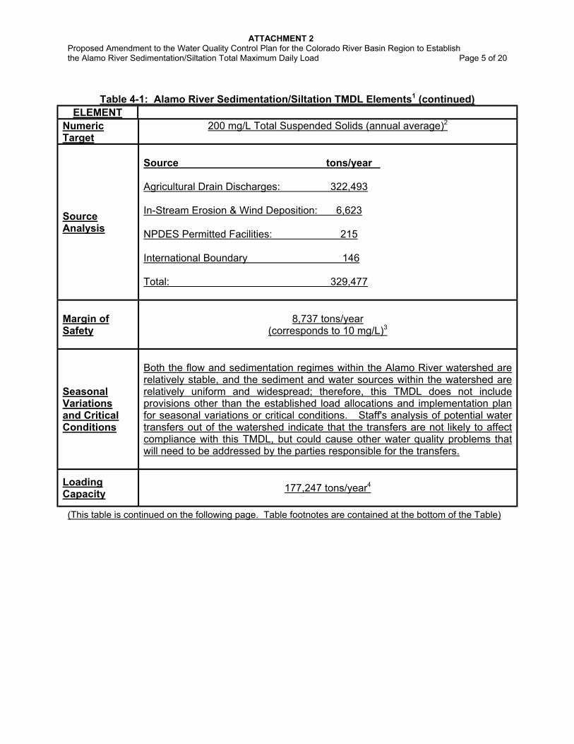
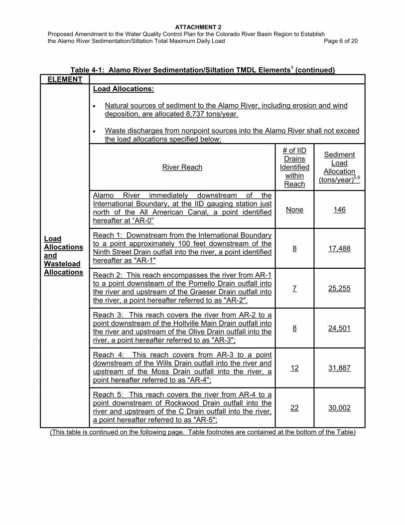
Table 4-1: Alamo River Sedimentation/Siltation TMDL Elements1
ELEMENT
Problem Statement
(impaired water quality
standard)
Excess delivery of sediment to the Alamo River has resulted in degraded conditions that impair the following designated beneficial uses: warm freshwater habitat; wildlife habitat; preservation of threatened, rare, and endangered species habitat; contact- and non-contact recreation; freshwater replenishment. As the Alamo River discharges into the Salton Sea, sediment also threatens the same beneficial uses of the Salton Sea. Specifically, sediment serves as a carrier for DDT, DDT metabolites, and other insoluble pesticides including toxaphene, which pose a threat to aquatic and avian communities and people feeding on fish from the Alamo River; and suspended solids concentrations, sediment loads, and turbidity levels are in violation of water quality objectives. These current concentrations, loads, and levels are also forming objectionable bottom deposits, which are also adversely affecting the beneficial uses of Alamo River.
(This table is continued on the following page. Table footnotes are contained at the bottom of the Table)
ATTACHMENT 2 Proposed Amendment to the Water Quality Control Plan for the Colorado River Basin Region to Establish the Alamo River Sedimentation/Siltation Total Maximum Daily Load Page 5 of 20
Table 4-1: Alamo River Sedimentation/Siltation TMDL Elements1 (continued)
Both the flow and sedimentation regimes within the Alamo River watershed are relatively stable, and the sediment and water sources within the watershed are relatively uniform and widespread; therefore, this TMDL does not include provisions other than the established load allocations and implementation plan for seasonal variations or critical conditions. Staff's analysis of potential water transfers out of the watershed indicate that the transfers are not likely to affect compliance with this TMDL, but could cause other water quality problems that will need to be addressed by the parties responsible for the transfers.
Loading Capacity
177,247 tons/year4
(This table is continued on the following page. Table footnotes are contained at the bottom of the Table)
ATTACHMENT 2 Proposed Amendment to the Water Quality Control Plan for the Colorado River Basin Region to Establish the Alamo River Sedimentation/Siltation Total Maximum Daily Load Page 6 of 20
Table 4-1: Alamo River Sedimentation/Siltation TMDL Elements1 (continued) ELEMENT
Load Allocations: • Natural sources of sediment to the Alamo River, including erosion and wind
deposition, are allocated 8,737 tons/year. • Waste discharges from nonpoint sources into the Alamo River shall not exceed
the load allocations specified below:
River Reach
# of IID Drains
Identified within Reach
Sediment Load
Allocation (tons/year)5,6
Alamo River immediately downstream of the International Boundary, at the IID gauging station just north of the All American Canal, a point identified hereafter at “AR-0”
None 146
Reach 1: Downstream from the International Boundary to a point approximately 100 feet downstream of the Ninth Street Drain outfall into the river, a point identified hereafter as "AR-1"
8 17,488
Reach 2: This reach encompasses the river from AR-1 to a point downsteam of the Pomello Drain outfall into the river and upstream of the Graeser Drain outfall into the river, a point hereafter referred to as "AR-2".
7 25,255
Reach 3: This reach covers the river from AR-2 to a point downstream of the Holtville Main Drain outfall into the river and upstream of the Olive Drain outfall into the river, a point hereafter referred to as "AR-3";
8 24,501
Reach 4: This reach covers from AR-3 to a point downstream of the Wills Drain outfall into the river and upstream of the Moss Drain outfall into the river, a point hereafter referred to as "AR-4";
12 31,887
Load Allocations and Wasteload Allocations
Reach 5: This reach covers the river from AR-4 to a point downstream of Rockwood Drain outfall into the river and upstream of the C Drain outfall into the river, a point hereafter referred to as "AR-5";
22 30,002
(This table is continued on the following page. Table footnotes are contained at the bottom of the Table)
ATTACHMENT 2 Proposed Amendment to the Water Quality Control Plan for the Colorado River Basin Region to Establish the Alamo River Sedimentation/Siltation Total Maximum Daily Load Page 7 of 20
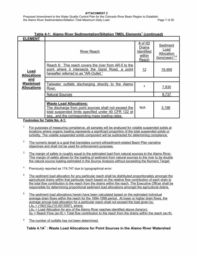
Table 4-1: Alamo River Sedimentation/Siltation TMDL Elements1 (continued)
ELEMENT
River Reach
# of IID Drains
Identified within Reach
Sediment Load
Allocation (tons/year) 5,6
Reach 6: This reach covers the river from AR-5 to the point where it intersects the Garst Road, a point hereafter referred to as "AR-Outlet.”
12 19,469
Tailwater outfalls discharging directly to the Alamo River.
a 7,830
Natural Sources 8,737
Load Allocations
and Wasteload Allocations
Waste Load Allocations: The discharge from point sources shall not exceed the total suspended limits specified under 40 CFR 122 et seq., and the corresponding mass loading rates.
N/A
3,196
Footnotes for Table No. 4-1: 1 For purposes of measuring compliance, all samples will be analyzed for volatile suspended solids at
locations where organic loading represents a significant proportion of the total suspended solids or turbidity. The volatile suspended solids component will be subtracted for determining compliance.
2 The numeric target is a goal that translates current silt/sediment-related Basin Plan narrative
objectives and shall not be used for enforcement purposes.
3 The margin of safety is roughly equal to the estimated load from natural sources to the Alamo River. This margin of safety allows for the loading of sediment from natural sources to the river to be double the natural source loading estimated in the Source Analysis without exceeding the Numeric Target.
4 Previously reported as 174,747 due to typographical error. 5 The sediment load allocation for any particular reach shall be distributed proportionately amongst the
agricultural drains within that particular reach based on the relative flow contribution of each drain to the total flow contribution to the reach from the drains within the reach. The Executive Officer shall be responsible for determining proportional sediment load allocations amongst the agricultural drains.
6 The sediment load allocations herein have been calculated based on the estimated individual average drain flows within the reach for the 1994-1999 period. At lower or higher drain flows, the average annual load allocation for a particular reach shall not exceed the load given by:
LAR = (180)*(QR)*(0.0013597), where: LAR = Load Allocation for any of the Alamo River reaches identified above (tons/yr). QR = Reach Flow (ac-ft) = Total flow contribution to the reach from the drains within the reach (ac-ft). a The number of outfalls has not been determined.
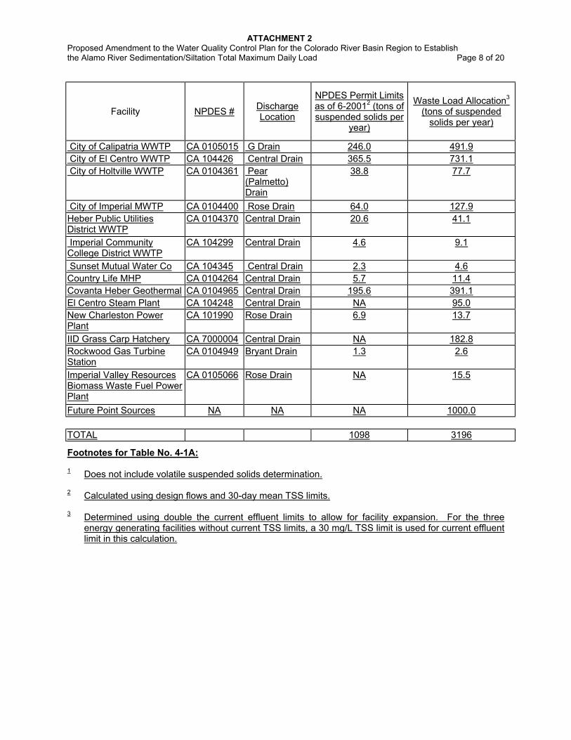
Table 4.1A1 : Waste Load Allocations for Point Sources in the Alamo River Watershed
ATTACHMENT 2 Proposed Amendment to the Water Quality Control Plan for the Colorado River Basin Region to Establish the Alamo River Sedimentation/Siltation Total Maximum Daily Load Page 8 of 20
Facility NPDES # Discharge Location
NPDES Permit Limits as of 6-20012 (tons of suspended solids per
year)
Waste Load Allocation3 (tons of suspended
solids per year)
City of Calipatria WWTP CA 0105015 G Drain 246.0 491.9 City of El Centro WWTP CA 104426 Central Drain 365.5 731.1 City of Holtville WWTP CA 0104361 Pear
(Palmetto) Drain
38.8 77.7
City of Imperial MWTP CA 0104400 Rose Drain 64.0 127.9 Heber Public Utilities District WWTP
CA 0104370 Central Drain 20.6 41.1
Imperial Community College District WWTP
CA 104299 Central Drain 4.6 9.1
Sunset Mutual Water Co CA 104345 Central Drain 2.3 4.6 Country Life MHP CA 0104264 Central Drain 5.7 11.4 Covanta Heber Geothermal CA 0104965 Central Drain 195.6 391.1 El Centro Steam Plant CA 104248 Central Drain NA 95.0 New Charleston Power Plant
CA 101990 Rose Drain 6.9 13.7
IID Grass Carp Hatchery CA 7000004 Central Drain NA 182.8 Rockwood Gas Turbine Station
CA 0104949 Bryant Drain 1.3 2.6
Imperial Valley Resources Biomass Waste Fuel Power Plant
CA 0105066 Rose Drain NA 15.5
Future Point Sources NA NA NA 1000.0 TOTAL 1098 3196
Footnotes for Table No. 4-1A: 1 Does not include volatile suspended solids determination. 2 Calculated using design flows and 30-day mean TSS limits.
3 Determined using double the current effluent limits to allow for facility expansion. For the three energy generating facilities without current TSS limits, a 30 mg/L TSS limit is used for current effluent limit in this calculation.
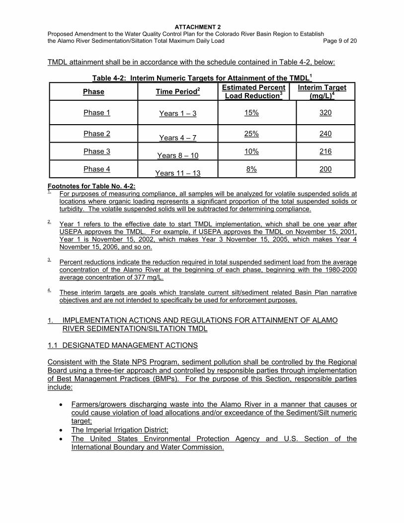
ATTACHMENT 2 Proposed Amendment to the Water Quality Control Plan for the Colorado River Basin Region to Establish the Alamo River Sedimentation/Siltation Total Maximum Daily Load Page 9 of 20 TMDL attainment shall be in accordance with the schedule contained in Table 4-2, below:
Table 4-2: Interim Numeric Targets for Attainment of the TMDL1
Phase Time Period2 Estimated Percent Load Reduction3
Interim Target (mg/L)4
Phase 1
Years 1 – 3 15% 320
Phase 2 Years 4 – 7 25% 240
Phase 3 Years 8 – 10 10% 216
Phase 4 Years 11 – 13 8% 200
Footnotes for Table No. 4-2: 1. For purposes of measuring compliance, all samples will be analyzed for volatile suspended solids at
locations where organic loading represents a significant proportion of the total suspended solids or turbidity. The volatile suspended solids will be subtracted for determining compliance.
2. Year 1 refers to the effective date to start TMDL implementation, which shall be one year after
USEPA approves the TMDL. For example, if USEPA approves the TMDL on November 15, 2001, Year 1 is November 15, 2002, which makes Year 3 November 15, 2005, which makes Year 4 November 15, 2006, and so on.
3. Percent reductions indicate the reduction required in total suspended sediment load from the average
concentration of the Alamo River at the beginning of each phase, beginning with the 1980-2000 average concentration of 377 mg/L.
4. These interim targets are goals which translate current silt/sediment related Basin Plan narrative
objectives and are not intended to specifically be used for enforcement purposes. 1. IMPLEMENTATION ACTIONS AND REGULATIONS FOR ATTAINMENT OF ALAMO
RIVER SEDIMENTATION/SILTATION TMDL 1.1 DESIGNATED MANAGEMENT ACTIONS Consistent with the State NPS Program, sediment pollution shall be controlled by the Regional Board using a three-tier approach and controlled by responsible parties through implementation of Best Management Practices (BMPs). For the purpose of this Section, responsible parties include:
• Farmers/growers discharging waste into the Alamo River in a manner that causes or could cause violation of load allocations and/or exceedance of the Sediment/Silt numeric target;
• The Imperial Irrigation District; • The United States Environmental Protection Agency and U.S. Section of the
International Boundary and Water Commission.
ATTACHMENT 2 Proposed Amendment to the Water Quality Control Plan for the Colorado River Basin Region to Establish the Alamo River Sedimentation/Siltation Total Maximum Daily Load Page 10 of 20 1.1.1 Farmers/growers Water Quality Management Plans The farmers/growers shall submit self-determined sediment control programs to the Regional Board by {insert the date that corresponds 15 months following the date of USEPA TMDL approval}*. A sediment control program may be submitted by an individual farmer/grower (hereafter "Individual Program") or by a group of farmers/growers (hereafter "Group Program"). In either case, the program shall, at a minimum, address the following components:
1. Name of farm owner, business address, mailing address, and phone number 2. Name of farm operator/grower, business address, mailing address, and phone number 3. Problem assessment (site location by address and township-range coordinates; site
condition(s), crop(s) typically grown in a five-year cycle and typical irrigation method for each crop; and potential or current NPS problems)
4. Statement of sediment control goals (measurable outcomes or products) 5. Existing and/or alternative sediment management practices (technical/economic
feasibility, desired outcome, etc.) 6. Timetable for implementation of management practices (measured in either water quality
improvement or level of implementation) 7. Monitoring for tailwater quality improvements, progress toward goals, and effectiveness
of management decisions 8. Mechanism for reporting planned and completed implementation actions to the Regional
Board A group program may address Item Nos. 1 through 6, above, for the individuals enrolled in the program as a group. The program shall nevertheless provide sufficient information so that the Regional Board can: (a) determine at a minimum on a drain- or drainshed-basis which responsible parties are enrolled in the program; (b) the types of sediment problems (i.e., severity, magnitude, and frequency) either the group as a whole or the drain/drainshed face; (c) the proposed sediment management practices for the group; and (d) the time table for implementation of the management practices (measured in either water quality improvement and/or level of implementation). Regarding Item Nos. 7 and 8, a single monitoring and reporting plan may also be proposed for a group provided that the monitoring and reporting will provide results that are representative of the efficiency of various control practices within the group and representative enough to measure overall water quality improvements. Reported implementation of BMPs shall be submitted to the Regional Board under the penalty of perjury. All programs and reports specified herein are requested pursuant to Section 13267 of the California Water Code. In accordance with Section 13267(b)(2) of the California Water Code, when requested by the responsible party or group furnishing a program, the portions of a program, which might disclose trade secrets or secret processes, shall not be made available for inspection by the public but shall be made available to governmental agencies for use in making studies. However, these portions of a program shall be available for use by the Regional Board or any state agency in judicial review or enforcement proceedings involving the person or group of persons furnishing the report.
* Note: Upon USEPA TMDL approval, this parenthetical “formula” will be replaced by the date certain, based on
the date of approval. The Executive Officer shall be responsible for determining proportional sediment load allocations amongst the agricultural drains.
ATTACHMENT 2 Proposed Amendment to the Water Quality Control Plan for the Colorado River Basin Region to Establish the Alamo River Sedimentation/Siltation Total Maximum Daily Load Page 11 of 20 1.1.2 The Imperial Irrigation District By {insert the date that corresponds to 15 months following the date of USEPA TMDL approval}*, the Imperial Irrigation District shall submit to the Regional Board a revised Drain Water Quality Improvement Plan (DWQIP) with a proposed program to control and monitor water quality impacts caused by drain maintenance operations within the Alamo River Watershed and dredging operations in the Alamo River. The revised DWQIP shall be subject to the approval of the Executive Officer and shall address, but need not be limited to, items “a” and “b”, below: a. Drain and Alamo River Delta Maintenance
• Reduction in drain cleaning and dredging activities to the practical extent allowed by the implementation of on- and off-field sediment control BMPs by the farmers/growers and the BMP effectiveness in reducing silt built up in the drains and the Alamo River Delta to avoid impacts on sensitive resources.
• Mechanism(s) to assess effectiveness of such reduction b. Drain Water Quality Monitoring Plan The revised DWQIP shall consist of a proposed program to monitor:
• Water quality impacts caused by dredging operations in the drains and to monitor the effects that dredging operations in the Alamo River Delta have on the river’s water quality standards;
• Representative samples from the water column of all major drains and a representative number of the small drains tributary to the Alamo River for analyses of flow, TSS, Turbidity, and nutrients. Samples collected from the last drain weir before the drain outfalls to the river shall be considered representative of the water column
• A representative number of source water locations for TSS; • A representative number of drains at a location sufficiently upstream of the outfalls to the
river so as to provide an idea of how much silt is being taking care of by field BMPs; • Sediment impacts from storm events;
c. Information on Agricultural Dischargers No later than {insert date that corresponds to 16 months following the date of USEPA TMDL approval} *, and on a semi-annual basis thereafter, the IID shall submit the following information to on the agricultural dischargers within the District: The names and mailing addresses for all the owners of properties within the IID service area that are being used for irrigated agriculture, as well as the location of their properties. The names and mailing addresses for all water account holders within the IID service area, their water account number and the location of all fields that they irrigate. For each parcel within the IID service area, the location of the parcel, the irrigation canal and gates serving the parcel, the drop boxes draining the parcel, the drains that these drop boxes empty into, and the fields located within each parcel. For each field within the IID service area, the parcel within which each field is located, the area and location of each field within the parcel, the irrigation canal and * Note: Upon USEPA TMDL approval, this parenthetical “formula” will be replaced by the date certain, based on
the date of approval. * Note: Upon USEPA approval, this parenthetical “formula” will be replaced by the date certain, based on the date
of approval.
ATTACHMENT 2 Proposed Amendment to the Water Quality Control Plan for the Colorado River Basin Region to Establish the Alamo River Sedimentation/Siltation Total Maximum Daily Load Page 12 of 20 gates serving each field, the drop boxes draining each field and the drains to which these drop boxes drain, and the crops being cultivated on each field.. The above information should be submitted in an electronic, tabular, and easily geo-referenced format. No later than 60 days following the Executive Officer’s approval of the revised DWQIP, the IID shall submit to the Executive Officer a Quality Assurance Project Plan (QAPP) prepared in accordance with Requirements for Quality Assurance Project Plans for Environmental Data Operations, EPA QA/R-5, 1994 for the revised DWQIP. The QAAP is subject to the approval of the Executive Officer. No later than 30 days following the Executive Officer’s approval of the QAPP, the IID shall implement the QAPP and submit monthly, quarterly, and annual monitoring reports to the Executive Officer. The monthly reports shall be due on the 15th day of the month and shall transmit the previous month's monitoring results, progress towards implementation of control practices, and performance of control practices. The quarterly reports shall be due on the 15th day of the month following the calendar's quarter and shall transmit a quarterly summary of the results for the previous three months. The annual reports shall be due on February 15 and summarize the year’s data, quality control reports, and any trends in the data. All plans and reports requested herein are requested pursuant to Section 13267 of the California Water Code and shall be prepared under the direct supervision of a California registered civil engineer and/or agricultural engineer, with experience in the preparation of this type of program. 1.1.3. United States Environmental Protection Agency (USEPA) and U.S. Section of the International Boundary and Water Commission (IBWC) By {insert the date that corresponds to 15 months following the date of USEPA TMDL approval}*, the USEPA and/or the U.S. Section of the IBWC shall submit to the Regional Board a technical report pursuant to Section 13225 of the California Water Code describing the proposed control measures, monitoring plan and reporting procedures, and quality assurance procedures the U.S. Government proposes to take to ensure that discharges of wastes from Mexico do not violate or contribute to a violation of this TMDL, particularly a violation of the Load Allocation immediately downstream of the International Boundary, at the point identified as “AR-0.”. The report shall be prepared under the direct supervision of a California registered civil engineer, with experience in the preparation of these types of reports and shall include a time schedule for implementation. 1.2 RECOMMENDED MANAGEMENT ACTIONS FOR FARMERS/GROWERS AND DRAINAGE MANAGEMENT Implementation of BMPs should normally include: (1) consideration of specific site conditions; (2) monitoring to assure that practices are properly applied and are effective; (3) improvement of a BMP or implementation of additional BMPs or other management practices when needed to resolve a deficiency and; (4) mitigation of a problem where the practices are not effective. The practices listed herein are a compilation of BMPs recommended by the Technical Advisory Committee for the Silt TMDL for the Alamo River (Silt TAC), the Natural Resources Conservation Services Field Office Technical Guide (NRCS FOTG), the IID, and the University of California Cooperative Extension (Holtville Field Station). Inclusion of practices herein is not meant to imply or establish a prescriptive list of 'one size fits all' preferred practices for the drainage basins tributary to the Alamo River. These recommendations do not preclude
ATTACHMENT 2 Proposed Amendment to the Water Quality Control Plan for the Colorado River Basin Region to Establish the Alamo River Sedimentation/Siltation Total Maximum Daily Load Page 13 of 20 dischargers from implementing other proven sediment management practices in order to be recognized as making a good-faith effort to control sediment discharges. Identification of the most appropriate controls to achieve the TMDL for site- and crop-specific conditions is best made by the landowner/operator relying on technical resource agencies and organizations. The listed practices are recommended because they have been documented to be effective under a variety of circumstances. Under many circumstances, implementation of a combination of BMPs may be necessary to ensure that discharges do not adversely impact water quality. In addition, the effectiveness of many BMPs can be greatly increased when they are used in conjunction with other BMPs. 1.2.1 ON-FIELD SEDIMENT CONTROL BMPs The following practices have been recommended for implementation as on-field sediment-control BMPs (references are in brackets): • Imperial Irrigation District Regulation No. 391
Imperial Irrigation District’s Regulation 39 states, in part, “It is the responsibility of each water user to maintain a tailwater structure and approach channel in acceptable condition, in order to qualify for delivery of water. An acceptable structure shall have vertical walls and a permanent, level grade board set a maximum of 12 inches below the natural surface. If the situation warrants, and at the discretion of the district, 18 inches maximum may be allowed.” See also: NRCS FOTG Conservation Practice “Structure for Water Control” (Code 587).
• Tailwater Drop Box with Raised Grade Board This practice involves maintenance of the grade board at an elevation high enough to
minimize erosion. In many situations the grade board elevation can be set higher than required by the IID Regulations, especially when anticipated tailwater flows will not reach an elevation that will cause crop damage. See also: NRCS FOTG Conservation Practice “Structure for Water Control” (Code 587).
• Improved Drop Box with Widened Weir and Raised Grade Board This practice involves widening the drop box overpour weir and maintaining the grade board
at an elevation high enough to minimize erosion. Widening the drop box overpour weir enables the weir elevation to be set higher without raising the surface elevation of the water above the acceptable level. Higher weir elevations allow for an increased tailwater ditch cross section, and reduced erosion when water leaving the field enters the tailwater ditch. See also: NRCS FOTG Conservation Practice “Structure for Water Control” (Code 587).
• Pan Ditch (Enlarged Tailwater Ditch Cross Section) This practice involves deepening and widening the tailwater ditch, which will result in
decreased tailwater velocity and depth. The water must be checked up downstream of the oversized area to make the cross section of the water as large as practical. The slower the velocity, the more sediment will settle out of the water and stay in the field, and the less will be picked up by the moving water. The effectiveness of this BMP can be further improved by planting grass filter strips in the tailwater ditch and/or installing tailwater ditch checks.
• Tailwater Ditch Checks or Check Dams
Tailwater Ditch Checks are temporary or permanent dams that hold the water level well above the ground. They can be placed at intervals in tailwater ditches, especially those with
1 The Imperial Irrigation District Regulation No. 39 is a required BMP by IID.
ATTACHMENT 2 Proposed Amendment to the Water Quality Control Plan for the Colorado River Basin Region to Establish the Alamo River Sedimentation/Siltation Total Maximum Daily Load Page 14 of 20
steeper slopes. They increase the cross section of the stream of water, decrease the water velocity and reduce erosion, and may cause sediment already in the water to settle out. Tailwater Ditch Checks can be constructed of plastic, concrete, fiber, metal or other suitable material. If plastic sheets are used, care must be taken not to allow pieces of the plastic to be carried downstream with the water. In order to be effective, this BMP must be utilized in condition where water velocities will not wash out the check dams or the sides of the tailwater ditch around the dams. Tailwater ditch checks or check dams are expected to work best in wide “pan ditches” where the width of tailwater stream can be effectively increased.
• Field to Tailditch Transition This practice involves use of spillways or pipes where water moves from fields into tailwater
ditches, allowing the tailwater to fall down into the tailwater ditch from the field without washing across and eroding the soil. Spillways might be constructed of plastic, concrete, metal, or other suitable material. If plastic sheets are used, care must be taken not to allow deterioration to cause pieces of the plastic to be carried downstream with the water. This procedure may be useful on fields irrigated in bordered-strips and furrows. Care must be taken to address erosion that may be caused in the tailditch at the location where the spillway discharges to the tailditch.
• Irrigation Land Leveling
This practice involves maintaining or adjusting field slope so as to avoid excessive slopes or low spots at the tail end of a field. In some cases it might be advantageous to maintain a reduced main or cross slope, which facilitates more uniform distribution of irrigation water and can result in reduced salt build-up in the soil, increased production, reduced tailwater, and decreased erosion. See also: NRCS FOTG Conservation Practice “Irrigation Land Leveling” (Code 464).
• Filter Strips
This practice involves elimination of borders on the last 20 to 200 feet of the field. Planted crop is maintained to the end of the field and tailwater from upper lands is used to irrigate the crop at the ends of the adjacent lower lands. It is important that the main slope on the lower end of the field is no greater than on the balance of the field. A reduced slope might be better. With no tailwater ditch, there should be very little erosion as the water slowly moves across a wide area of the field to the tailwater box. Some sediment might settle out as the crop slows the water while it moves across the field. This could be used with water tolerant crops or special soil conditions. See also: NRCS FOTG Conservation Practice “Filter Strip” (Code 393).
• Irrigation Water Management Irrigation Water Management is defined as determining and controlling the rate, amount,
and timing of irrigation water in a planned manner. Effective implementation of this practice can result in minimizing on-farm soil erosion and the subsequent transport of sediments into receiving waters. S Specific methods of Irrigation Water Management include: Surge Irrigation, Cut-Back Irrigation, Irrigation Scheduling, and the Runoff Reduction Method. In some cases, irrigation water management could include the employment of an additional irrigator to assist in better monitoring and managing irrigation water and addressing potential erosion problems. Irrigator Water Quality Training could provide irrigators with the knowledge necessarily to implement IWM and other sediment control practices. See also:
ATTACHMENT 2 Proposed Amendment to the Water Quality Control Plan for the Colorado River Basin Region to Establish the Alamo River Sedimentation/Siltation Total Maximum Daily Load Page 15 of 20
NRCS FOTG Conservation Practice “Improved Water Application” (Code 197, CA Interim) and NRCS FOTG Conservation Practice “Irrigation Water Management” (Code 449).
• Sprinkler Irrigation Sprinkler irrigation involves water distribution by means of sprinklers or spray nozzles. The purpose of this practice is to efficiently and uniformly apply irrigation water to maintain adequate soils moisture for optimum plant growth without causing excessive water loss, erosion, or reduced water quality. See also: NRCS FOTG Conservation Practice “Irrigation System, Sprinkler” (Code 442).
• Drip Irrigation Drip irrigation consists of a network of pipes and emitters that apply water to the surface or subsurface of the soil in the form of spray or a small stream.
• Reduced Tillage
This practice is the elimination of at least one cultivation per crop. It integrates weed control practices in order to maximize the effectiveness of cultivating weed control, but at the same time minimize erosion and sedimentation that may occur in the furrow.
• Furrow Dikes (also known as “C-Taps”)
Furrow dikes are small dikes created in furrows to manage the velocity of the water in the furrow. They can be either constructed of earth and built with an attachment to tillage equipment, pre-manufactured “C-Taps,” or other material, including rolled fiber mat, plastic, etc.
1.2.2 OFF-FIELD SEDIMENT CONTROL BMPs The following practices have been recommended as off-field sediment-control BMPs (references are in brackets):
• Channel Vegetation/Grassed Waterway
This practice involves establishing and maintaining adequate plants on channel banks and associated areas to stabilize channel banks and adjacent areas and reduce erosion and sedimentation, and establishing maximum side slopes. This practice serves to stabilize the channel bank, reducing the potential for bank failure. See also: NRCS FOTG Conservation Practice “Channel Vegetation” (Code 322) and NRCS FOTG Conservation Practice “Grassed Waterway” (Code 412).
• Irrigation Canal or Lateral
This practice applies to irrigation drainage channels. One objective of the practice is to prevent erosion or degradation of water quality. Drainage channels should be designed to develop velocities that are non-erosive for the soil materials of which the channel is constructed. .See also: NRCS FOTG Conservation Practice “Irrigation Canal or Lateral” (Code 320).
• Sediment Basins
Sediment basins are constructed to collect and store debris or sediment. The capacity of the sediment basin should be sufficient to store irrigation tailwater flows for long enough to allow most of the sediments within the water to settle out. The sediment basins also must be cleaned regularly to maintain their capacity and effectiveness.
ATTACHMENT 2 Proposed Amendment to the Water Quality Control Plan for the Colorado River Basin Region to Establish the Alamo River Sedimentation/Siltation Total Maximum Daily Load Page 16 of 20 1.2.3 ESTIMATED COST OF IMPLEMENTATION AND SOURCES OF FINANCING The estimated total cost or implementing BMPs range from $5.00 to $52.50 per acre per year, which is generally estimated to be less than 2% of production cost. The development of Farm Water Quality Management Plans are estimated to be less than $200.00 per field. Monitoring costs are estimated to range from $100.00 to $500.00 depending on the monitoring program. The preparation of the IID monitoring plan is estimated to be $25,000. Implementation of the IID monitoring plan is estimated to be $70,000 per year, and the characterization of dredging impacts is estimated to be $20,000. Potential sources of financing are: Private financing by individual sources; Bond indebtedness or loans from government institutions; Surcharge on water deliveries to lands contributing to the sediment pollution problem; Taxes and fees levied by the Irrigation District that provides drainage management; State and/or Federal grants and low-interest loans, including State Proposition 13 (Costa-Machado Act of 2000) grant funds and Federal Clean Water Act Section 319(h) grant funds; and, Single purpose appropriations from Federal and/or state legislative bodies.
1.3. RECOMMENDED ACTIONS FOR COOPERATING AGENCIES
1.3.1. IMPERIAL COUNTY FARM BUREAU VOLUNTARY WATERSHED PROGRAM The Imperial County Farm Bureau (ICFB) initiated a “Voluntary Watershed Program” in 1999, in which it committed to development of program elements, including “outreach programs and mechanisms to encourage and foster an effective self-determined approach to attainment of TMDL load applications.” To implement the program, the ICFB has committed to make contact with every farm landowner, renter/leaser, and operator, within one year, and to supply material related to the TMDL process, its ramifications, and implementation alternatives. The specific goals of the Voluntary Watershed Program include: (1) coordination of workshops with local technical assistance agencies, (2) development of local subwatershed (“drainshed”) groups, (3) identification of leaders, within each of the local subwatershed groups, who will provide demonstration implementation sites for field-testing of BMPs, (4) cooperation with Regional Board staff to develop a process for the subwatershed groups to track and report planned and implemented on-the-ground implementation and effectiveness of BMPs, and (5) provide linkage to technical assistance agencies for BMP implementation assistance. The ICFB has designated the geographical areas for ten (10) subwatershed groups, each covering approximately 50,000 acres of irrigated land. These geographical designations are to be utilized in the ICFB Voluntary Watershed Program’s approach to education and implementation. Although the Imperial County Farm Bureau is not a regulatory agency, it has committed to develop and implement a “Voluntary Watershed Program” that can play a vital role in achieving TMDL waste load allocations. Therefore, it is appropriate to recommend that the ICFB prepare, submit, and implement the following:
a. ICFB WATERSHED PROGRAM PLAN The Imperial County Farm Bureau should:
• By {insert the date that corresponds to 13 months following the date of USEPA TMDL approval}*, issue letters to all potential program participants within the Alamo River watershed that describes the ICFB Voluntary Watershed Program.
* Note: Upon USEPA TMDL approval, this parenthetical “formula” will be replaced by the date certain, based on
the date of approval.
ATTACHMENT 2 Proposed Amendment to the Water Quality Control Plan for the Colorado River Basin Region to Establish the Alamo River Sedimentation/Siltation Total Maximum Daily Load Page 17 of 20
• By {insert the date that corresponds to 15 months following the date of USEPA TMDL approval}*, provide the Regional Board with a list of program participants, organized by subwatershed (“drainshed”).
• By {insert the date that corresponds to 15 months following the date of USEPA TMDL approval}*, submit the ICFB Watershed Program Plan to the Regional Board. The Plan should (1) identify measurable environmental and programmatic goals; (2) describe aggressive, reasonable milestones and timelines for the development and implementation of TMDL outreach plans; (3) describe aggressive, reasonable milestones and timelines for the development of sub-watershed (“drainshed”) plans; (4) describe a commitment to develop and implement a tracking and reporting program.
• Submit semi-monthly reports to the Executive Officer that describe the progress of each of the subwatershed groups, any technical assistance workshops that are planned or were conducted, and any other pertinent information.
b. ICFB TRACKING AND REPORTING PROCEDURES The Imperial County Farm Bureau should also:
• By {insert the date that corresponds to 16 months following the date of USEPA TMDL approval}*, submit a plan describing the process and procedures for tracking and reporting implementation of BMPs (and other proven management practices) and BMP performance to the Regional Board’s Executive Officer.
• Implement the tracking and reporting procedures. • Submit semi-monthly written reports assessing trends in the data and level of adoption
of the process and procedures throughout each of the sub-watersheds (“drainsheds”) to the Executive Officer.
• Submit a yearly summary report to the Executive Officer by 15th of February of each year.
1.3.2 UNIVERSITY OF CALIFORNIA COOPERATIVE EXTENSION The Regional Board supports efforts of the University of California Cooperative Extension to provide interested growers information on sediment control BMPs, implement projects qualitatively assessing BMP performance, and develop farm water quality planning programs. 1.3.3 NRCS The Regional Board recommends that the NRCS require control of irrigation-induced erosion as part of the Farm Plans developed under the Environmental Quality Incentives Program (EQIP) or other federal grant programs. V. VI. ACTIONS OF OTHER AUTHORITIES Page 6-3, edit "B. COMPLIANCE MONITORING" so it reads as follows: B. COMPLIANCE MONITORING 1. Regulated Facilities Under this task, data is Data from facilities with waste discharge requirements, including NPDES permits, are collected and used to determine compliance with waste discharge requirements and receiving water standards and to support enforcement actions…
ATTACHMENT 2 Proposed Amendment to the Water Quality Control Plan for the Colorado River Basin Region to Establish the Alamo River Sedimentation/Siltation Total Maximum Daily Load Page 18 of 20 Page 6-3, in between the first and second paragraphs under "B. COMPLIANCE MONITORING", add the following heading: 1. Recommended Biomonitoring (Toxicity Monitoring) Programs Page 6-4, following the last paragraph under "B. COMPLIANCE MONITORING", add the following: 2. New River Pathogen TMDL 3. Alamo River Sedimentation/Siltation TMDL 3.1 Compliance Assurance and Enforcement As provided in the State Board's Water Quality Enforcement Policy, prompt, consistent, predictable, and fair enforcement are necessary to deter and correct violations of water quality standards, violations of the California Water Code, and to ensure that responsible parties carry out their responsibilities for meeting the TMDL allocations. This is particularly necessary to adequately deal with those responsible parties who fail to implement self-determined or regulatory-encouraged sediment control measures, which are essentially the cornerstone of the State's NPS Program. To this end, the Regional Board may use use, as the circumstances of the case may warrant, any combination of the following:
• Implementation and enforcement of Section 13267 of the California Water Code to ensure that all responsible parties submit, in a prompt and complete manner, the Water Quality Management Plan defined in Chapter 4, Section V(B)(1.1.1).
• Consideration of adoption of waste discharge requirements, pursuant to Section 13263 of the California Water Code, as appropriate (i.e., for any responsible party who fails to implement voluntary or regulatory-encouraged sediment controls).
• Consideration of adoption of an enforcement orders pursuant to Section 13304 of the California Water Code against any responsible party who violates Regional Board waste discharge requirements and/or fails to implement voluntary or regulatory-encouraged sediment control measures to prevent and mitigate sediment pollution or threatened pollution of surface waters.
• Consideration of adoption of enforcement orders pursuant to Section 13301 of the California Water Code against those who violate Regional Board waste discharge requirements and/or prohibitions.
• Consideration of Administrative Civil Liability Complaints, as provided for by the California Water Code, against any responsible party who fails to comply with Regional Board orders, prohibitions, and requests.
• Consideration of adoption of referrals of recalcitrant violators of Regional Board orders and prohibitions to the District Attorney or Attorney General for criminal or civil prosecution, respectively.
From the standpoint of measuring progress, any cropland discharge with a concentration of suspended solids, measuring more than 375 mg/l (or about 270 NTU for turbidity) and absent reasonable implementation of BMPs would be considered unsatisfactory. Samples will be analyzed for volatile suspended solids at locations where organic loading represent a significant
ATTACHMENT 2 Proposed Amendment to the Water Quality Control Plan for the Colorado River Basin Region to Establish the Alamo River Sedimentation/Siltation Total Maximum Daily Load Page 19 of 20 proportion of the total suspended solids or turbidity. The volatile suspended solids component will be subtracted. Further, in assessing the status of compliance with Load Allocations specified in Table No. 4-1 of any responsible party who is in either Tier I or Tier II, the Regional Board shall consider, in addition to water quality results, the degree to which the responsible party has implemented, or is implementing, sediment control measures. In the absence of true progress the Regional Board directs the Executive Officer to draft requirements that will fulfill the sediment control measures. The numeric target is a goal that translates current silt/sediment-related Basin Plan narrative objectives and shall not be used for enforcement purposes. 3.2. Monitoring and Tracking Tracking TMDL and monitoring water quality progress, and modifying TMDLs and implementation plans as necessary to ensure attainment of water quality standards are important to address uncertainty that may exist in aspects of TMDL development, oversee TMDL implementation to ensure that implementation is being carried out, and to ensure that the TMDL remains effective, given changes that may occur in the watershed after the TMDL is developed. (All monitoring activities are contingent on funding through fund-source specific workplans.) • Water Quality Monitoring and Assessment
Regional Board water quality monitoring activities for the Alamo River Sedimentation/Siltation TMDL Monitoring and Tracking Program shall be conducted pursuant to a Quality Assurance Project Plan for the Alamo River (QAPP-AR). The QAPP-AR shall: (1) include a sufficient number of sampling stations along the Alamo River to determine progress towards compliance with the TMDL and overall water quality improvement; (2) provide for monthly monitoring of flow, field turbidity, laboratory turbidity, total suspended solids in the river; and (3) provide for quarterly monitoring of DDT and DDT metabolites in the river's water column.
• TMDL Implementation Tracking
Implementation Tracking Plan: Implementation of sediment control activities shall be tracked by Regional Board staff and
shall be reported to the Regional Board at least yearly. • Assessment and Reporting
On a yearly basis, the Regional Board staff will prepare a report assessing compliance with the TMDL Goals and Milestones. In the report, staff will assess the following:
- Water quality improvement (in terms of total suspended sediments, total sediment loads, DDT and metabolites, total phosphate)
- Trends in BMP implementation - BMP effectiveness/performance/ and costs - Whether milestones were met on time or at all. If milestones were not met, provide a
discussion of the reasons, and a recommendation - Level of compliance with measures and timelines agreed to in Program Plans and
associated time schedules. - Level of compliance with measures and timelines agreed to in Drainshed Plans.
ATTACHMENT 2 Proposed Amendment to the Water Quality Control Plan for the Colorado River Basin Region to Establish the Alamo River Sedimentation/Siltation Total Maximum Daily Load Page 20 of 20 • Regular Review
The Regional Board shall hold public hearings at least every three years to review the level of implementation of BMPs, effectiveness of the BMPs, and overall progress of the sediment control practices. At these hearings, the following shall be considered:
- Monitoring results to date - Progress toward attainment of milestones - Changes or trends in implementation of BMPs - Modification/addition of management practices for the control of sediment discharges - Revision of TMDL components and/or development of site-specific water quality
objectives Review of subcategories of water quality standards related to this TMDL and/or attainability
of the TMDL may also be appropriate after the parties responsible for TMDL implementation submit appropriate documentation that sediment control practices (e.g., BMPs) are being implemented on a widespread-basis in the Alamo River Subwatershed, that the control practices are being properly implemented and maintained, and that additional controls would result in substantial and widespread economic and social impact. The Regional Board 303(d) listing of the silt/sediment impairment for the Alamo River and tributary drains shall also be re-evaluated.
The first public hearing shall be scheduled by no later than three years after the date
following USEPA TMDL approval of this Basin Plan amendment.