Attachment A Response to Submissions Horsley Drive Business Park Stage 2 – Building 1 State Significant Development Application SSD 10404 Submitted to Department of Planning & Environment On behalf of Charter Hall 25 June 2020 | 2190880
Transcript
Attachment A Response to Submissions
Horsley Drive Business Park Stage 2 – Building 1
State Significant Development Application
SSD 10404
Submitted to Department of Planning &
Environment
On behalf of Charter Hall
25 June 2020 | 2190880
Horsley Drive Business Park Stage 2 – Building 1 State Significant Development Application SSD 10404| June 2020
Ethos Urban | 16611 2
1.0 Introduction
The proponent, Charter Hall and its specialist consultant team have reviewed and considered all issues raised, as detailed within the table below. This response provides a detailed response to the issues raised and outlines any proposed amendments to the exhibited Environmental Impact Statement.
As outlined within below, we are of the view that there are no further issues precluding the Department from finalising its assessment and that the proposal should be
recommended for approval.
2.0 List of Abbreviations
CEMP Construction Environmental Management Plan
DPE Department of Planning and Environment
EIS Environmental Impact Statement prepared for SSD 10404
EP&A Act Environmental Planning and Assessment Act 1979 (NSW)
EPA Environment Protection Authority of NSW
SSD State significant development under the EP&A Act
Horsley Drive Business Park Stage 2 – Building 1 State Significant Development Application SSD 10404| June 2020
Ethos Urban | 16611 3
3.0 Detailed Response to Submissions Table
Issues Raised by Agencies and Organisations Proponent’s Response
Department of Planning & Environment
Scope of SSD-10404
It is unclear on reading the EIS and specialist reports if they have been written on the basis that SSD 7664 – Modification 1, which is currently before the
Department, will be approved as submitted. This requires clarification.
• SSDA 10404 is submitted on the basis SSDA 7664 MOD 1 is approved.
The Response to Submissions (RTS) needs to clearly set out what aspects form part of SSD-10404, SSD 7664, or SSD 7764 Modification 1.
• SSDA 10404 is for the proposed Customer Fulfillment Centre on proposed Lot 1.
• SSDA 7664 as modified (MOD 1) relates to all site works, estate roadworks and offsite roadworks and associated services including land consolidation and subdivision.
• The proposed amendments sought under SSD 7664 MOD 1 are described in detail within Section 4.1.1 of the Response to Submissions Report.
Site Layout
An amended site plan which clearly illustrates for example existing lot
boundaries, topographic contours, lot sizes, building envelopes, easements, existing infrastructure.
• Lot consolidation is being sought under SSD 7664 MOD 1 and does not relate to SSD 10404.
• The existing lots that form part of approval SSD 7664 include Lots 17-22 DP 13961 and Lot 2 DP 1212087.
• SSD 7664 MOD 1 sought approval to consolidate the existing 7 lots into 4 lots.
• The proposed CFC facility is located on proposed Lot 1.
• An amended site plan demonstrating the consolidated lot boundary is attached at Appendix B.
Confirm that Lots 17 and 18 do not form part of SSD 10404. • SSD 10404 relates to proposed Lot 1 and does not include in any works in the northern portion of the site.
• SSD 10404 excludes Lot 17, 18 and 19 in DP13691 and is limited to Lots 20, 21 and 22 in DP 13961 and Lot 2 in DP 1212087.
Confirm if lot consolidation is being sought under SSD 10404. If so, the
amended site plan should reflect this and a plan of consolidation, provided. • Lot consolidation/ subdivision on is being sought under SSDA 7664 & Mod 1.
• The Overall Site Plan for SSDA 10404 demonstrates the consolidated lots as per approval under SSD 7764 MOD 1 with the CDC facility located on Lot 1.
Clarify what the site area and development footprint are.
Confirm distances to sensitive receivers from the site boundary of SSD 10404 and not SSD 7664.
• Distances to sensitive receivers from the site boundary stated in the Operational Noise and Vibration Impact Assessment for SSD 10404 is correct.
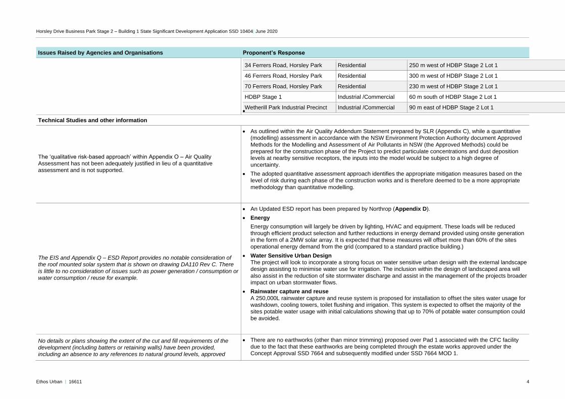
Surrounding Sensitive Receivers
Address Type Distance (m) from Site Boundary
28 Trivet Street, Wetherill Park (82 Cowpasture Road, Wetherill Park)
Residential 180 m northeast of HDBP Stage 2 Lot 1
Horsley Drive Business Park Stage 2 – Building 1 State Significant Development Application SSD 10404| June 2020
Ethos Urban | 16611 4
Issues Raised by Agencies and Organisations Proponent’s Response
34 Ferrers Road, Horsley Park Residential 250 m west of HDBP Stage 2 Lot 1
46 Ferrers Road, Horsley Park Residential 300 m west of HDBP Stage 2 Lot 1
70 Ferrers Road, Horsley Park Residential 230 m west of HDBP Stage 2 Lot 1
HDBP Stage 1 Industrial /Commercial 60 m south of HDBP Stage 2 Lot 1
Wetherill Park Industrial Precinct Industrial /Commercial 90 m east of HDBP Stage 2 Lot 1 •
Technical Studies and other information
The ‘qualitative risk-based approach’ within Appendix O – Air Quality Assessment has not been adequately justified in lieu of a quantitative assessment and is not supported.
• As outlined within the Air Quality Addendum Statement prepared by SLR (Appendix C), while a quantitative (modelling) assessment in accordance with the NSW Environment Protection Authority document Approved
Methods for the Modelling and Assessment of Air Pollutants in NSW (the Approved Methods) could be prepared for the construction phase of the Project to predict particulate concentrations and dust deposition levels at nearby sensitive receptors, the inputs into the model would be subject to a high degree of
uncertainty.
• The adopted quantitative assessment approach identifies the appropriate mitigation measures based on the level of risk during each phase of the construction works and is therefore deemed to be a more appropriate
methodology than quantitative modelling.
The EIS and Appendix Q – ESD Report provides no notable consideration of the roof mounted solar system that is shown on drawing DA110 Rev C. There
is little to no consideration of issues such as power generation / consumption or water consumption / reuse for example.
• An Updated ESD report has been prepared by Northrop (Appendix D).
• Energy
Energy consumption will largely be driven by lighting, HVAC and equipment. These loads will be reduced
through efficient product selection and further reductions in energy demand provided using onsite generation in the form of a 2MW solar array. It is expected that these measures will offset more than 60% of the sites operational energy demand from the grid (compared to a standard practice building.)
• Water Sensitive Urban Design
The project will look to incorporate a strong focus on water sensitive urban design with the external landscape design assisting to minimise water use for irrigation. The inclusion within the design of landscaped area will
also assist in the reduction of site stormwater discharge and assist in the management of the projects broader impact on urban stormwater flows.
• Rainwater capture and reuse
A 250,000L rainwater capture and reuse system is proposed for installation to offset the sites water usage for washdown, cooling towers, toilet flushing and irrigation. This system is expected to offset the majority of the sites potable water usage with initial calculations showing that up to 70% of potable water consumption could
be avoided.
No details or plans showing the extent of the cut and fill requirements of the development (including batters or retaining walls) have been provided, including an absence to any references to natural ground levels, approved
• There are no earthworks (other than minor trimming) proposed over Pad 1 associated with the CFC facility due to the fact that these earthworks are being completed through the estate works approved under the Concept Approval SSD 7664 and subsequently modified under SSD 7664 MOD 1.
Horsley Drive Business Park Stage 2 – Building 1 State Significant Development Application SSD 10404| June 2020
Ethos Urban | 16611 5
Issues Raised by Agencies and Organisations Proponent’s Response
surface levels, or to be approved surface levels on any of the elevations or
section drawings. This level of information should be provided, including a cut / fill heat map.
• The reporting and technical responses submitted with SSD 104040 reflect that the cut and fill requirements
over Pad 1 have been approved under the Concept Approval and as such, no additional earthworks drawings have been submitted in support of SSD 10404.
An assessment of construction noise associated with the construction of this
facility has not been provided.
• A Noise and Vibration Impact Assessment is provided at Appendix E. The key findings of this report include:
• No exceedance of the Noise Management Levels is predicted at any receivers during all construction activity in Lot 1 during standard construction hours.
• Construction traffic is not predicted to increase daytime road traffic noise levels by more than 2 dBA at the nearest sensitive receivers.
• Vibration levels at the nearest receiver are unlikely to be above the cosmetic damage criteria.
Matters of National Environmental Significance have not been addressed.
• EPBC Act Matters of National Environmental Significance have been addressed by Ethos Urban within the Response to Submissions report.
• A Biodiversity Development Assessment Report (BDAR) was prepared by Ecoplanning (dated 24 November 2016) in support of SSD 7664 as part of the approval for Concept Proposal and Stage 1 works for the establishment of a warehouse, distribution and industrial facility at the Horsley Drive Business Park Stage 2
within the Western Sydney Parklands (WSP).
• SSD 7664 is currently the subject of a Modification Application for which an updated BDAR has been prepared by EcoLogical (dated 7 April 2020). The updated BDAR recognises that the EPBC Act establishes a process for assessing the environmental impact of activities and developments where MNES may be
affected.
• Given Matters of National Environmental Significance have been dealt with under SSD 7664 and the subsequent Modification Application, further assessment as part of SSD 10404 is not warranted.
Confirm whether site access and amendments to Cowpasture Road and Trivet
Street are being sought under SSD-10404 or SSD 7664 Modification 1. • Site access and road reconfiguration is subject of SSDA 7664 MOD 1.
Provide a process description and illustration of how the development will
operate. • A detailed overview of the process description for the proposed CFC facility has been provided in Section
4.1.3 of the Response to Submissions report.
Hazards and Risk
It is noted that there is a wide variety of dangerous goods listed in the Dangerous Goods (DG) Assessment, please provide the representative products that may represent DG Class 1.4s and DG Class 5.1 and describe
how these products are being handled in the proposed development.
• Class 1.4s products include party poppers, sparklers and general birthday party goods in small containers. These products are considered to be low risk, with only a minor quantity of explosive in each component.
• Class 5.1 products are typically hydrogen peroxide-based hair dyes which contain between 8-12% hydrogen peroxide. These are also considered low risk as the hydrogen peroxide will only decompose into oxygen and
hydrogen when dried and exposed to a high temperature.
Confirm the location of the diesel storage. • The diesel storage is proposed in a packaged fuel tank/dispensing facility nominated as "Van Re-fuel" on the
overall site plan (DA 020). Please refer to the Architectural plans attached at Appendix B.
Horsley Drive Business Park Stage 2 – Building 1 State Significant Development Application SSD 10404| June 2020
Ethos Urban | 16611 6
Issues Raised by Agencies and Organisations Proponent’s Response
Clarify whether the forklifts are fuelled by LPG, diesel or electricity. Please also indicate the forklift filling or charging location.
• All forklifts are intended to be fuelled by LPG using small refill bottles. Gas (bullet) is located external to the
facility in hardstand and only handled during re-fill.
Confirm whether all DG products to be handled within the proposed Automated
System warehouse are household packaged product. • It is confirmed that all DG products to be handled within the proposed Automated System warehouse are
household packaged retail products.
How will the DG products be categorised within the distribution centre? Is there
the potential for incompatible substances to be stored together?
• The storage logic can be programmed to dedicate particular storage areas to a DG class. Only DG classes which align with that designation can be stored within that location.
• The separation table from AS 3833 will be used to guide the DG separation within the automated warehouse system to minimise the potential for co-location. In addition, the DGs are stored in self contained totes; hence any spillage from a package would be contained within a tote and unlikely to mix with other products during
storage.
• Only undamaged products are introduced into totes so the potential for damage to occur once located in a tote is minimal.
It is stated in the Preliminary Hazard Analysis that Ammonia/Glycol is low
charge with 500g. Where will this refrigeration unit and the associated ammonia
storage be located?
• In review of the Preliminary Hazard Analysis, the appointed refrigeration contractor has confirmed that the Ammonia/Glycol will be low charge with 300g and is to be stored in the plant room.
Inconsistencies
Section 4.3 of the EIS states that the detailed design guidelines under the concept plan have a nominated building height of 15 metres, whereas Condition A10 of the concept plan provides a maximum building height of 16
metres. The development controls of SSD 7664 have not been adequately addressed; and
• Section 4.3 of the EIS makes an incorrect reference to the maximum building height approved under SSD 7664.
• The proposal seeks approval for a maximum building height in accordance with Concept Approval maximum building height of 16 metres.
Appendix H – Civil Engineering Report SSD 10404 – Section 6.2 states that
“Indoor and outdoor water demand and rainwater tank sizing will be based on individual site requirements and form part of separate future development
applications…”. Clarification as to what future development applications would submit this level of information, rather than SSD 10404 is required. Alternatively, it would be expected that this detail would be provided as part of
this development.
• A 250,000L rainwater capture and reuse system is proposed for installation to offset the sites water usage for washdown, cooling towers, toilet flushing and irrigation. This system is expected to offset the majority of the sites potable water usage with initial calculations showing that up to 70% of potable water consumption could
be avoided (Please refer to the amended ESD Report prepared by Northrop at Appendix D).
• The Civil Engineering Report SSD 10404 (Appendix F) has been updated to reflect indoor and outdoor water demand and rainwater tank sizing for the development.
Horsley Drive Business Park Stage 2 – Building 1 State Significant Development Application SSD 10404| June 2020
Ethos Urban | 16611 7
Issues Raised by Agencies and Organisations Proponent’s Response
Fairfield City Council
TRAFFIC MANAGEMENT
Access Arrangements Trivet Street and Cowpasture Road
The proposal will alter existing access arrangements for privately owned
industrial lots through the placement of a roundabout at the intersection of
Trivet Street and Cowpasture Road (see table 1 below). Table 1 – Property Address
Property Address
105 Cowpasture Road, Wetherill Park 109 Cowpasture Road, Wetherill Park 115 – 119 Cowpasture Road, Wetherill
Park 121 – 123 Cowpasture Road, Wetherill Park
In Council’s correspondence dated 11 December 2019 it was stated that the owners of these lots be should consulted and their agreement provided to the
revised access arrangements. The draft EIS states that the proponent will undertake consultation with affected owners post development and suggests that this requirement be conditioned in the SSD Approval.
Council has concerns with this approach and requests that the proponent undertake consultation with affected landowners and seek approval in writing from them as soon as practicable. Council notes that approval from the
Western Sydney parklands Trust has been sought over the proposal.
• Council’s submission specifically raised the proposed access arrangements at Trivet Street and Cowpasture Road and that the owners of the following lots be should consulted and their agreement provided in relation to
the revised access arrangements:
- 105 Cowpasture Road, Wetherill Park.
- 109 Cowpasture Road, Wetherill Park.
- 115-119 Cowpasture Road, Wetherill Park.
- 121-123 Cowpasture Road, Wetherill Park.
• As outlined within the EIS, a letter was prepared and provided to nearby stakeholders and community
members most likely considered to be impacted by the development. The letter provided the following elements.
- details of the proposed development.
- details of changes to the surrounding road network.
- details of changes to the Concept Masterplan per SSD 7664.
- details of the proposed CDC facility.
• Following the lodgement of SSD 10404, the Applicant has undertaken the additional consultation with each of the landowners of the affected properties in response to Fairfield City Council’s request.
• This has been detailed within the Response to Submissions Report.
• The affected stakeholders have now had an opportunity to provide formal comment during the public
notification period and further, to discuss the application directly with the Applicant, and at no stage have any objections to the proposal been raised.
Traffic Impacts Assessment (TIA)
• The TIA by Ason traffic group has modelled the developments impacts on key intersections in a pre and post development scenario including:
- The two signalised intersections at Cowpasture Road/Horsley Drive and
Ferrers Road/Horsley Drive
- Roundabout intersections at Burdilla Road/Cowpasture Road,
- Newton Road/Cowpasture Road,
- Cowpasture Road/Horsley Drive and
- Victoria Street Cowpasture Road.
• An Updated Transport Assessment has been prepared by ASON Group and is provided at Appendix G.
Horsley Drive Business Park Stage 2 – Building 1 State Significant Development Application SSD 10404| June 2020
Ethos Urban | 16611 8
Issues Raised by Agencies and Organisations Proponent’s Response
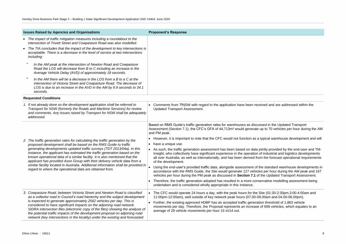
• The impact of traffic mitigation measures including a roundabout to the
intersection of Trivett Street and Cowpasture Road was also modelled.
• The TIA concludes that the impact of the development to key intersections is acceptable. There is a decrease in the level of service at two intersections
including:
- In the AM peak at the intersection of Newton Road and Cowpasture
Road the LOS will decrease from B to C including an increase in the
Average Vehicle Delay (AVD) of approximately 18 seconds.
- In the AM there will be a decrease in the LOS from a B to a C at the intersection of Victoria Street and Cowpasture Road. The decrease of
LOS is due to an increase in the AVD in the AM by 9.9 seconds to 34.1 seconds.
Requested Conditions
1. If not already done so the development application shall be referred to Transport for NSW (formerly the Roads and Maritime Services) for review
and comments. Any issues raised by Transport for NSW shall be adequately
addressed.
• Comments from TfNSW with regard to the application have been received and are addressed within the Updated Transport Assessment.
2. The traffic generation rates for calculating the traffic generation by the
proposed development shall be based on the RMS Guide to traffic generating developments updated traffic surveys (TDT 2013/04a). In this instance, the applicant has estimated the traffic generation based on the
known operational data of a similar facility. It is also mentioned that the applicant has provided Ason Group with their delivery vehicle data from a similar facility located in Australia. Additional information shall be provided in
regard to where the operational data are obtained from.
Based on RMS Guide’s traffic generation rates for warehouses as discussed in the Updated Transport Assessment (Section 7.1), the CFC’s GFA of 44,713m² would generate up to 70 vehicles per hour during the AM and PM peak.
• However, it is important to note that the CFC would not function as a typical warehouse development and will
• have a unique use.
• As such, the traffic generation assessment has been based on data jointly provided by the end-user and TM-Insight, who collectively have significant experience in the operation of industrial and logistics developments
all over Australia, as well as internationally, and has been derived from the forecast operational requirements of the development.
• Using the end-user’s provided traffic data, alongside assessment of the standard warehouse developments in
accordance with the RMS Guide, the Site would generate 127 vehicles per hour during the AM peak and 167 vehicles per hour during the PM peak as discussed in Section 7.1 of the Updated Transport Assessment.
• Therefore, the traffic generation adopted has resulted in a more conservative modelling assessment being undertaken and is considered wholly appropriate in this instance.
3. Cowpasture Road, between Victoria Street and Newton Road is classified
as a collector road in Council’s road hierarchy and the subject development is expected to generate approximately 2562 vehicles per day. This is
considered to have significant impacts on the adjoining road network.
SIDRA intersection files (electronic copy of the files) showing the analysis of the potential traffic impacts of the development proposal on adjoining road network (key intersections in the locality) under the existing and forecasted
• The CFC would operate 24 hours a day, with the peak hours for the Site (01:30-2:30pm,3:00-4:00am and
11:00pm-12:00am), well outside of key network peak hours (07.00-09.00am and 04.00-06.00pm).
• Further, the existing approved HDBP has an accepted traffic generation threshold of 1,863 vehicle movements per day. Therefore, the Proposal represents an increase of 699 vehicles, which equates to an average of 29 vehicle movements per hour 15 in/14 out.
Horsley Drive Business Park Stage 2 – Building 1 State Significant Development Application SSD 10404| June 2020
Ethos Urban | 16611 9
Issues Raised by Agencies and Organisations Proponent’s Response
conditions shall be submitted to Council for assessment. In addition, the
applicant shall increase the capacity of Cowpasture Road at/near the site and this information shall be provided to Council for assessment.
• This volume of additional traffic over that already approved would materially impact capacity of Cowpasture
Road in the vicinity of the Site. Nevertheless, amid-block capacity assessment of Cowpasture Road has been undertaken to demonstrate the impact of the Proposal of capacity along Cowpasture Road between Victoria Street and Newton Road.
• Taking the northbound and southbound peak hour traffic volumes at the Victoria Street / Cowpasture Road roundabout intersection, the following mid-block traffic volumes can be estimated:
• The mid-block LOS has been determined using the RMS Guide – Urban road peak hour flows per direction for one lane. Considering the trip distribution and the peak hour generation of the entire Estate traffic, the
resulting mid-block volumes and LOS are the following:
Table: Future CFC Mid-Block Hourly Volumes
Direction AM Peak LOS PM Peak LOS
Northbound 617 DC 492 C
Southbound 642 D 660 D
• As such, the LOS would decrease from C to D during the AM and PM peak. This is still a satisfactory outcome for the mid-block assessment. Importantly, the mid-block assessment only shows the increased southbound movement results in only17-60 vehicles over the LOS C threshold indicating it would operate
close to a LOS C.
• Therefore, the increased traffic flows per hour along Cowpasture Road is acceptable under the mid-block assessment.
• Electronic SIDRA files will be provided.
3a. The proposed parking rate of 1 space for every 300m2 of warehouses of GFA requires justification. This parking rate shall be consistent with the
parking rate that has been adopted for Horsley Drive (HDBP) Stage 1 for the warehouse development.
• An Updated Transport Assessment has been prepared by ASON Group and is provided at Appendix G.
• It is critical to note that reference has been made to approved carparking rate of 1 car space for every 300m² GFA for the HDBP as this is the rate that is applicable to the Site under the approved SSD-7664.
• Nonetheless, given the unique use of the Proposal, the parking supply has been determined via a first-principle assessment based on the specific employee requirements for the CFC Therefore, an accurate
Horsley Drive Business Park Stage 2 – Building 1 State Significant Development Application SSD 10404| June 2020
Ethos Urban | 16611 10
Issues Raised by Agencies and Organisations Proponent’s Response
provision of parking supply has been provided. The resulting parking supply is therefore higher than 1 space
per 300m² GFA.
4. The applicant shall justify the sight distance requirement for commercial vehicles entering and exiting from the Estate Road shall comply with Figure 3.3 of AS 2890.2:2018.
• Sight distance for the CFC’s commercial vehicle exit driveways on the Estate Road has adequate sight distance requirements of 69m which equates to a minimum 5 second gap for a 50km/hr road as per AS2890.2.2018 Figure 3.3.
• An Updated Transport Assessment has been prepared by ASON Group and is provided at Appendix G.
5. The CFC proposes the following 5 access driveways to and from the site
• Heavy vehicle entry driveway: 11.7m wide
• Heavy vehicle exit driveway: 8m wide
• Delivery vehicle entry driveway: 12.6m wide
• Delivery vehicle exit driveway: 8m wide
• Staff entry driveway: 4m wide
• Staff exit driveway: 6m wide
The information related to the turning path analysis is incomplete. Swept paths
showing the different types of vehicles (design vehicles) manoeuvring into,
within and out of the site shall be submitted to Council for assessment. Swept path analysis shall also demonstrate how the heavy vehicles can manoeuvring into and out of the loading bays.
• An Updated Transport Assessment has been prepared by ASON Group and is provided at Appendix G.
• The CFC facility access driveway layout has now been revised as reflected in the updated architectural drawings.
• Detailed swept path analysis for access driveway manoeuvres and loading dock movement are contained within the Updated Transport Assessment.
6. Clarification is required regarding the truck entry/exit driveway located at the
western end of the Estate Road whether this is a combined entry/exit
driveway. In addition, the proposed driveway location is directly adjacent to the driveway of the adjoining property. There will be potential conflicts
between vehicles entering and exiting the two sites. The applicant shall review the location of the proposed driveway to minimise potential conflicting movements.
• The driveway located at the western end of the Estate Road is to be a single exit driveway for CFC trucks
only. With regard to any other access points for the northern lots on the proposed Estate Road, there are currently no existing or approved, detailed plans for access points (refer to Appendix G – Updated Transport Assessment).
• The proposed access points to the other lots within HDBP Stage 2 will be subject to separate, detailed SSD applications and should be considered at the appropriate stage.
• On the basis of the Transport Assessment prepared by ASON Group and submitted with the Modification Application (SSD 7664 MOD 1), it is expected that the GFA that could be achieved on the adjacent northern
Lot 2, would result in a low peak hour heavy vehicle traffic generation of approximately 5 heavy vehicles per hour.
• A driveway which would generate this volume of traffic during the peak would be acceptable in this location.
• The current locations of the access driveways proposed under the Modification application to SSD7664 (which is subject to a separate application process) is a consistent approach to that delivered on Burilda Close (HDBP Stage 1).
7. Road safety audit shall be undertaken by a qualified person to identify
whether there are issues/risks associated with the installation of a
roundabout at the intersection of Cowpasture Road and Trivet Street. A
• This requirement has been appropriately addressed via a Condition of Consent in relation to SSD 7664 MOD 1.
Horsley Drive Business Park Stage 2 – Building 1 State Significant Development Application SSD 10404| June 2020
Ethos Urban | 16611 11
Issues Raised by Agencies and Organisations Proponent’s Response
copy of the road safety audit report prepared by an accredited Road Safety
Auditor shall be submitted to Council for assessment.
8. The installation of traffic control devices such as a roundabout, signs and line markings on a public road requires community support and approval from the Fairfield Traffic Committee. Subject to the outcome of the road
safety audit, the applicant shall undertake consultation with the stakeholders
and submit Council a copy of the consultation outcome for assessment. Council’s Traffic and Transport Branch will assist the applicant in relation to
the approval process.
• This requirement has been appropriately addressed via a Condition of Consent in relation to SSD 7664 MOD 1.
9. Considering the number of trucks and delivery vehicles which are expected to attend the site on a daily basis, a loading dock management plan is required. The loading dock management plan is to ensure that trucks will be
parked within the site without impacting traffic flow into, within and out of the site. Additional measures may be required to prevent additional trucks or commercial vehicles from entering the site when all of the loading bays are
occupied.
• This will be addressed as a Condition of Consent prior to issue of Occupation Certificate.
10. No information is provided regarding the provision of designated loading
bays for 26m B-Double vehicles to service the site. Service vehicles shall only undertake loading and unloading activities from the designated loading areas and shall not obstruct the car parking areas and traffic flow
within the site. Additional information shall be provided to Council for assessment.
• As with any other industrial development, loading of a larger vehicle such a B-double would be managed on-site, in accordance with the operational management plan.
• Swept path analysis shows that B-doubles can successfully exit the docks.
• For incoming B-double vehicles, it is expected that they would be uncoupled, with the trailers manoeuvred
into the bays as AVs. This is standard practice and will not impact internal traffic flow in an unacceptable manner when considered against the traffic generation.
• It should be noted that all carparking areas and circulation roads are separated from heavy vehicle movements.
11. Architectural/Site plans showing the dimensions of the proposed vehicle access, internal access road width, loading bays, trailer parking bays, car parking, van parking, bicycle parking, motorcycle parking, disabled spaces
and ramp grades to and from various parking and loading areas of the site shall be submitted to Council for assessment.
• Please refer to update architectural plan set for relevant dimensions (Appendix B).
• Note that it is considered unnecessary to provide dimensions for all parking bays – all loading bays, trailer parking bays, car parking, van parking, bicycle parking, motorcycle parking and disabled spaces have been designed with regard to the Australian Standards and it is expected that this would be required as part of any
Condition of Consent and would be subsequently certified by a qualified professional.
12. Longitudinal sections of the proposed access driveways for service
vehicles/deliver vehicles to access the site shall be submitted to Council for assessment.
• Please refer to Updated Civil Engineering Report (Appendix F) and updated architectural plans (Appendix
B).
13. A review of the site plan indicates that parking spaces are proposed in a
stacked arrangement at the south-western corner of the site. According to
the Fairfield City Wide DCP, Council generally does not favour the use of stacked parking within the site unless further justification is provided. In this regard, the applicant is required to submit Council further information
• The south-western corner of the Site provides for stacked parking spaces / storage for Prime Movers, Trailers and Delivery Vans for operational purposes of the Proposal and are not for cars.
• These spaces would be operated by staff who are skilled heavy vehicle drivers who would park the vehicles there for storage or for waiting purposes, in line with the operational management plan.
Horsley Drive Business Park Stage 2 – Building 1 State Significant Development Application SSD 10404| June 2020
Ethos Urban | 16611 12
Issues Raised by Agencies and Organisations Proponent’s Response
in regard to the management of stacked parking. The applicant shall
demonstrate that the provision of stacked parking arrangement will not adversely affect the safe, efficient and effective use of the site.
14. The construction of an Estate Road to service the development shall be referred to Council’s Subdivision Branch for review and assessment. The design of the Estate Road shall comply with Council’s requirement.
• It is critical to note that these works will be approved and undertaken as part of the Modification to SSD-7664, which is being assessed in concurrence with this SSD (SSD-10404). The Proposal cannot be implemented
without approval of the Modification to SSD-7664.
15. The installation of a roundabout requires changes to the access arrangements to the adjacent properties which will require consent from the affected stakeholders. The affected stakeholders shall be consulted
regarding the proposed changes and the outcome of the consultation shall be submitted to Council for assessment.
• It is critical to note that these works will be approved and undertaken as part of the Modification to SSD-7664, which is being assessed in concurrence with this SSD (SSD-10404). Therefore, the roundabout and right turn bay would be implemented as part of SSD-7664. The Proposal cannot be implemented without approval of the Modification to SSD-7664.
16. As Chandos Road and Trivet Street are 5-tonne load limited streets, heavy vehicles shall be restricted from accessing these roads.
• Noted. Heavy vehicles shall be restricted from accessing Chandos Road and Trivet Street.
17. The applicant shall justify the length of the right turn bay proposed on
Cowpasture Road is sufficient. The proposed right-turn bay is to facilitate access to the properties affected by the realignment of Cowpasture Road.
This proposal requires consultation to be undertaken with the affected
stakeholders and a copy of the consultation outcome shall be submitted to Council for assessment.
• It is critical to note that these works will be approved and undertaken as part of the Modification to SSD-7664, which is being assessed in concurrence with this SSD (SSD-10404). Therefore, the roundabout and right turn
bay would be implemented as part of SSD-7664.
• Based on aerial analysis undertaken as part of the Transport Assessment (Appendix G), the two sites that would use the right turn bays are shown below:
• The approximate warehouse GFA from the aerial imagery is some 10,000m² warehouse GFA.
• Applying the AM Peak trip generation of 0.156 trips / 100m2 GFA and PM Peak trip generation of 0.157 trips /
100m2 GFA, this equates to 16 trips during the AM and PM peak hour.
• Assuming a 75:25 arrival and departure split during the AM peak, there would be a peak of 12 vehicles per hour requiring the right turn, during the peak. This equates to on average 1 vehicle every 5 minutes.
Horsley Drive Business Park Stage 2 – Building 1 State Significant Development Application SSD 10404| June 2020
Ethos Urban | 16611 13
Issues Raised by Agencies and Organisations Proponent’s Response
• As such, the proposed 30m right turn bay would be able to accommodate the low peak hour right turn traffic
demands.
• Consultation with stakeholder will be undertaken for this proposed right-turn bay as part of Construction Certificate works.
NATURAL RESOURCES
Biodiversity Assessment Report Waiver (BDAR)
The proponent has indicated that a BDAR waiver was sought for the project. A
BDAR waiver has since been issued by DPIE. However, Council notes that a BDAR has been submitted as part of SSD 7664 which will be assessed in line with Council officers previous comments on that application, including the
requirement to provide a copy of receipt for the retirement of 34 ecosystem credits.
• Please refer to the Biodiversity Assessment Report Addendum Letter provided at Appendix H.
HERITAGE
The overall design is considered to be visually dominant however this aspect of
the proposal has already been approved as part of Stage 1. Furthermore, the
precedent has already been established for this level of development and the use of the site for the purposes of a large- scale business park. No further heritage comments are therefore made. Conditions should be applied to the
consent, which ensure that any potential affected indigenous and non- indigenous heritage is protected as part of the development.
• Noted.
Requested Heritage Conditions
1. Protection of Upper Canal System
Prior to the issuing of Construction Certificate or the commencement of
construction, the applicant should prepare and propose a construction
management plan, which demonstrates that the development will not result in any adverse impacts on the exiting State Heritage Item. The plan should identify but must not be limited to the following:
a) Transport routes prior to, during and post construction, which avoid the heritage item and any likely impact on this;
b) Protective measures that will ensure the item is protected at all times
during construction and utilisation;
c) Areas identified for the storage of any building materials, machinery, spoil and utilities for tradespeople, which avoids any adverse impact
on the heritage item; and
d) Any other process of developing the site that would have an impact.
• Noted.
• The proposed requirements are found to be acceptable and can be suitably conditioned during the design phase.
Horsley Drive Business Park Stage 2 – Building 1 State Significant Development Application SSD 10404| June 2020
Ethos Urban | 16611 14
Issues Raised by Agencies and Organisations Proponent’s Response
2. Landscape Plan
The applicant should prepare a landscape plan that outlines any proposed
landscaping at the rear of the site and adjoining the state heritage item. The landscaping elements should be appropriately designed to not undermine the State Heritage Item.
• An Updated Landscape Plan has been prepared by Geoscapes Landscape Architects (Appendix J) that
identifies the proposed landscape works associated with the CFC Facility (SSD 10404).
• The proposal does not propose any works at the rear of the site and adjoining the state heritage item. These components of the wider site have been assessed in relation to SSD 7664 (as modified).
• No Landscape works, beyond those already documented in relation to the CFC facility, are proposed as part of this application.
3. Archaeology
In accordance with Section 146 of the NSW Heritage Act, during the demolition, excavation or construction works; if any deposits, objects or relics are
uncovered; the works are to stop immediately, and the NSW Heritage Council notified of the discovery.
Depending on the nature of the discovery and advice from the NSW Heritage Council, an application for an excavation permit under Section 140 of the NSW Heritage Act may be required to be made.
• The proposed requirements are found to be acceptable and can be suitably conditioned during the design phase.
• The CEMP prepared by Charter Hall submitted with the EIS incorporates an Unexpected Finds Procedure to
ensure that all actual or potential heritage items uncovered during construction are protected.
• This includes Aboriginal objects, Historic (non-Aboriginal heritage items) and Human Skeletal remains.
• The amended CEMP includes additional measures to ensure any potential heritage items are always protected during construction and utilisation.
4. Indigenous Heritage
In accordance with Council’s Aboriginal Heritage Study, this condition is applied in addition to Condition 1 Archaeology (above) to ensure that any objects of potential indigenous significance are protected. Such objects are not
specifically protected by the relics provision as outlined by the NSW Heritage Council.
The National Parks & Wildlife Act (1974) provides statutory protection for all Aboriginal ‘objects’ (consisting of any material evidence of the Aboriginal occupation of NSW) under Section 90 of the Act, and for ‘Aboriginal Places’
(areas of cultural significance to the Aboriginal community) under Section 84. It
is an offence to harm either an Aboriginal object or Aboriginal Place in NSW. The Act defines an Aboriginal ‘object’:
‘as any deposit, object or material evidence (not being a handicraft for sale) relating to indigenous and non-European habitation of the area that comprises New South Wales, being habitation before or concurrent with
the occupation of that area by persons of non- Aboriginal European extraction, and includes Aboriginal remains’.
Works must be stopped in the instance where there is a suspected discovery of
an ‘object’ in accordance with the above definition and a valid and applicable Aboriginal Heritage Impact Permit be obtained under Section 90 of the NPW
Act.
• Noted.
• The CEMP prepared by Charter Hall incorporates an Unexpected Finds Procedure which work ceases in the instance where there is a suspected discovery of an ‘object’ in accordance with the National Parks & Wildlife Act (1974).
Horsley Drive Business Park Stage 2 – Building 1 State Significant Development Application SSD 10404| June 2020
Ethos Urban | 16611 15
Issues Raised by Agencies and Organisations Proponent’s Response
CATCHMENT MANAGEMENT
Water conservation
A General statement regarding the provision of 50% reduced water consumption, exceeds the 40% requirement within the Water conservation section of the FCC Stormwater Management Policy 2017, this is acceptable.
These details are to be provided at DA stage.
• A strong focus has been put on the effective management of water within the building with the following
initiatives being included in the design in all areas throughout the project.
• It is expected that these initiatives will reduce the sites potable water demand by more than 50% compared to a standard practice building.
• Please refer to the amended ESD Report prepared by Northrop at Appendix D.
DRAINS modelling
The Parameters per the FCC Stormwater Management Policy 2017, Appendix Q have not been adhered to, however the parameters used are deemed acceptable.
• Noted.
• Please refer to Civil Engineering response at Appendix F.
Floor levels with respect to flooding
The proposed buildings finished floor levels (FFL) are 67.5m Australian Height Datum (AHD). Council officers have reviewed the updated flood modelling for the site, and found the flood level at the rear (western edge) of the proposed
building to be 67.2 m AHD. This is described as ‘flooding’ it is more accurately
described as drainage or a local flow path. Therefore, only 300mm freeboard is required for a local overland flow path (Stormwater Management Policy),
compared to the standard 500mm for mainstream or overland flooding (FCC Citywide DCP). The required 300mm freeboard has been achieved.
• Noted.
• Stormwater management will be undertaken as part of approved SSD 7664 (as modified) Horsley Business
Park Stage 2 measures.
ENVIRONMENTAL MANAGEMENT
Council’s Environmental Management Section (EMS) does not have any objection to the proposal. EMS recommends that the following conditions should be adopted by the determining Authority:
• Noted.
Environmental Reports Certification
Within three (3) months from the date of the modified consent, written certification from a suitably qualified person(s) shall be submitted to NSW Environment Protection Authority and Fairfield City Council, stating that all
works/methods/procedures/control measures/recommendations approved in the following reports have been completed:
a. Environmental Impact Statement, prepared by Ethos Urban Pty Ltd,
28 February 2020
b. Noise and Vibration Impact Assessment prepared by SLR Consulting dated February 2020
c. Dangerous goods report prepared by Riskcon engineering dated 4 February 2020
d. Air quality Report prepared by SLR dated 24 January 2020
• The recommendation of a 3-month timeframe for all works, methods, procedures, control measures and
recommendations to be completed is overly restrictive and unreasonable due to current market conditions and the nature and scale of the proposed development.
• Charter Hall is committed to achieving the conditions outlined in the EIS and approved supporting documentation within six (6) months from the date of the consent.
Horsley Drive Business Park Stage 2 – Building 1 State Significant Development Application SSD 10404| June 2020
Ethos Urban | 16611 16
Issues Raised by Agencies and Organisations Proponent’s Response
e. Waste Management Plan prepared by FDC dated 9/1/2020
Use of the Premises
The use of the premises shall comply with the following requirements:
• The operation of the business shall be conducted so as to avoid unreasonable noise and cause no interference to adjoining or nearby
residences.
• The use of the premises shall not give rise to “offensive noise” as defined under the Protection of the Environment Operations Act, 1997.
• Emission of sound from the premises shall be controlled at all times so as not to unreasonably impact upon nearby owners/occupants.
• The use of the premises is not to interfere with the amenity of the residential area.
• If an intruder alarm is installed on the premises it shall be fitted with a timing device in accordance with the requirements of the Protection of the Environment Operations Act, 1997.
• The premises shall be maintained in a clean and tidy state at all times. In this regard, cleaning shall be carried out as required to ensure that the premises is maintained in an environmentally satisfactory manner.
• Noted.
• The proposed requirements are found to be acceptable and can be suitably conditioned.
Unreasonable Noise and Vibration
• The industry, including operation of vehicles, shall be conducted so as to avoid unreasonable noise or vibration and cause no interference to
adjoining or nearby occupations. Special precautions must be taken to avoid
nuisance in neighbouring residential areas, particularly from machinery, vehicles, warning sirens, public address systems and the like.
• In the event of a noise or vibration problem arising at the time, the person in charge of the premises shall when instructed by Council, cause to be carried out, an acoustic investigation by an appropriate acoustical consultant and submit the results to Council. If required by Council, the person in charge of
the premises shall implement any or all of the recommendations of the consultant and any additional requirements of Council to Council’s satisfaction.
• As detailed within the Noise and Vibration Impact Assessment prepared by SLR and submitted with this response at Appendix E, noise mitigation measures will be implemented to minimise noise levels from the
Project.
These include:
• Briefing the work team and contractors to create awareness of the proximity of noise-sensitive residential receivers and the importance of minimising noise emissions.
• Using ‘quiet’ work practices to minimise noise, where possible.
• Use of less noise-intensive equipment, where feasible and reasonable.
• Adjusting reversing alarm volume on heavy equipment to make them ‘smarter’, by limiting the acoustic range to immediate danger area, where acceptable under the relevant safety procedures.
• Enclosure of outdoor fixed plant (such as mechanical plant) where practicable
• For equipment with enclosures, ensure door and seals are well maintained and kept closed when not in use
• It is considered that the implementation of the above mitigation measures will suitably ensure the proposal does not result in unreasonable noise and vibration.
Odour Complaint • Noted.
Horsley Drive Business Park Stage 2 – Building 1 State Significant Development Application SSD 10404| June 2020
Ethos Urban | 16611 17
Issues Raised by Agencies and Organisations Proponent’s Response
• An odour impact assessment shall be submitted to Council if any complaints
are lodged with regulatory authority in relation to the emissions generated from the operation of the business. The report must be prepared by a suitably qualified environmental consultant and include modelling of the
odour impact on the nearest affected receptor (e.g. residents/property occupants).
Any recommendations resulting from the report are to be in accordance with
AS/NZS 1668.1– 2015: The use of ventilation and air conditioning in buildings – Fire and smoke control in buildings and AS 1668.2 – 2015: The use of
ventilation and air conditioning in buildings – Mechanical ventilation in buildings, as well as the Office of Environment & Heritage Technical Framework – Assessments and Management of Odour from Stationary
Sources in NSW (November 2006).
Storage of Flammable and Combustible Liquids
Flammable and combustible liquids shall be stored in accordance with AS 1940-2004 – The Storage and Handling of Flammable and Combustible
Liquids.
• Noted.
Storage of Hazardous Chemicals
Should any ‘hazardous chemicals’ proposed to be stored on the premises exceed the manifest quantity as prescribed in Schedule 11 of the Work Health
Safety Regulation 2011, Notification of schedule 11 hazardous chemicals is required to be submitted to SafeWork NSW.
• The facility has been designed using AS/NZS 3833:2007 which is the standard which covers the mixed storage of multiple DG classes in retail distribution centres.
• AS 1940-2017 is only specific for flammable and combustible liquids. The site has been designed to ensure any spills or potentially contaminated fire water would be contained within the site premises.
NSW Protection of the Environment Operations Act 1997
The use of the premises shall operate in accordance with the Protection of the
Environment Operations Act (POEO) 1997. All activities and operations carried
out shall not give rise to air pollution (including odour), offensive noise or pollution of land and/or water as defined under the Protection of the Environment Operations Act 1997.
• Noted.
CONCLUSIONS
Council officers have reviewed the SSD application including the Draft EIS. It is
recommended that the draft heritage conditions that form part of this response be appropriately conditioned as part of this approval, as well as any further heritage recommendations that may arise from external agency consultation.
There are still outstanding issues regarding the assessment of traffic impacts
that must be dealt with prior to project approval. Agreement from the owners of adjacent lots at the Trivett Street/Cowpasture Road intersection whose access
• Noted.
Horsley Drive Business Park Stage 2 – Building 1 State Significant Development Application SSD 10404| June 2020
Ethos Urban | 16611 18
Issues Raised by Agencies and Organisations Proponent’s Response
will change because of the proposal must be given priority with their agreement
obtained prior to project approval.
HERITAGE NSW
The proposed development involves construction of Building 1 (an industrial warehouse to operate as a customer fulfilment centre) and associated utilities,
infrastructure, parking and landscape works within the Horsley Business Park
Stage 2, occupying approximately 8.79ha of the wider 16.5ha site. It is noted the balance of the site under the existing Concept approval (SSD 7664) will be subject to a separate future application.
The proposed State Significant Development site adjoins the State Heritage Register (SHR) item, Upper Canal System (Pheasants Nest Weir to Prospect
Reservoir) – SHR no. 1373. The Upper Canal System is significant as a major component of the Upper Nepean Scheme. As an element of this Scheme, the Canal has functioned as part of Sydney's main water supply system since
1888. The Upper Canal is separated from the site by a cycleway and a low
fence, which forms part of its SHR listed curtilage.
• Noted.
Requested Conditions
The EIS prepared by Ethos Urban and relevant accompanying documentation have been reviewed.
As delegate of the Heritage Council of NSW, it is recommended that the following conditions be included as part of the approval:
a) The following recommendations of the Historical heritage advice prepared by Biosis dated 22 January 2020 shall be implemented to avoid impact on the
heritage significance of the Upper Canal System (Pheasants Nest Weir to Prospect Reservoir) – SHR no. 1373:
• No physical impacts must occur within the curtilage of the Upper Canal (Lot 1 DP 596354).
• Building envelope must be sufficiently setback from the western edge of the lots to ensure that the development does not have an adverse impact on the heritage significance of the Upper Canal.
• A landscape area shall be developed along the canal as a soft barrier to protect its setting. Landscaping shall include shrubs and trees capable of reaching and thus buffering proposed building height.
• Building design shall feature recessive neutral external colour scheme and finishes and shall avoid high, blank walls facing the Canal to minimise visual impacts.
• The proposed requirements are found to be acceptable and can be suitably conditioned in the design phase.
• The mitigation measures outlined in the Response to Submissions Report (Section 9.0) to safeguard against any negative impacts on the heritage significance of the Upper Canal are supported by WaterNSW.
Horsley Drive Business Park Stage 2 – Building 1 State Significant Development Application SSD 10404| June 2020
Ethos Urban | 16611 19
Issues Raised by Agencies and Organisations Proponent’s Response
• The applicant must ensure that proposed works comply with the Guidelines
for Development Adjacent to the Upper Canal and Warragamba Pipelines (WaterNSW 2018).
b) The applicant must ensure that if unexpected archaeological deposits or relics not identified and considered in the supporting documents for this
approval are discovered, work must cease in the affected area(s) and the
Heritage Council of NSW must be notified. Additional assessment and approval may be required prior to works continuing in the affected area(s) based on the
nature of the discovery.
• The proposed requirements are found to be acceptable and can be suitably conditioned in the design phase.
• The CEMP prepared by Charter Hall incorporates an Unexpected Finds Procedure to ensure that all actual or potential heritage items uncovered during construction are protected.
• This includes Aboriginal objects, Historic (non-Aboriginal heritage items) and Human Skeletal remains.
• The CEMP submitted with the EIS includes additional measures to ensure any potential heritage items are always protected during construction and utilisation.
ENVIRONMENT NSW
Aboriginal Cultural Heritage Assessment Report As part of the request for SEARs EES recommended that an ACHAR be
prepared. DPIE did not include this requirement within the final SEARs that were issued, therefore, an ACHAR was not prepared.
• Noted.
Biodiversity A Biodiversity Development Assessment Report (BDAR) Waiver Request has
been submitted and a response will be forwarded under separate cover.
• Noted.
Flooding EES has reviewed the following reports:
• Prospect Creek Floodplain Management Plan Review prepared by Bewsher Consulting dated March 2010 for Fairfield City Council
• Civil Engineering Report for SSD10404 Development Application prepared, by Costin Roe Consulting dated 2020.
• The development site is in the upper end of the Prospect Creek Catchment
and above the PMF level, and the submitted document is considered adequate for the management of local drainage and flooding problems within the development site and the downstream areas.
• Noted.
TRANSPORT NSW
TfNSW has reviewed the submitted documents and provides the following comments for consideration:
1. It is noted the majority of impact of the proposed development will be at the intersection of Cowpasture Road and Trivett Street, Wetherill Park. This intersection is the responsibility of Fairfield Council. It is also noted that
proposed intersection works are reflected in SSD 7664 (MOD 1).
• Noted.
2. It is noted Cowpasture intersects with The Horsley Drive, a classified road. The intersection will receive greater traffic volumes from the M7 with the future
• The SIDRA analysis indicates that the resulting development’s traffic would cause Cowpasture Road / Victoria Street roundabout to decrease from LOS B to LOS C. This decrease in LOS occurs for the AM peak
Horsley Drive Business Park Stage 2 – Building 1 State Significant Development Application SSD 10404| June 2020
Ethos Urban | 16611 20
Issues Raised by Agencies and Organisations Proponent’s Response
widening of the Horsley Drive. Priority would be given to southbound and
northbound right turns to minimise overflow to the roundabout of The Horsley Drive/Cowpasture Road/Lizard Log access, therefore motorists turning right from Cowpasture Road/Victoria Street must accept delays for the intersection
growth. Extra capacity or alternate access onto The Horsley Drive should be considered.
right turn movements from Cowpasture Road to Victoria Street as a result of a 9-10 second increase in delay
from 20.9 to 30.2 seconds. The worst delay of 34.1 seconds occurs for the U-turn movement with only 2 vehicles per hour projected to utilise this movement.
• Under the RMS Guide, LOS C occurs between 29-42 seconds of delay. As such, the primary right turn
movement is only 1.2 seconds higher than a LOS B which indicates that the resulting LOS decrease is only marginal. This is an acceptable outcome as it indicates that the roundabout would still operate satisfactorily. We note that The Horsley Drive upgrade would be undertaken in the future which would provide additional
capacity along The Horsley Drive and reduce the future PM peak hour delays at the existing roundabout.
• Please refer to Appendix G – Updated Transport Assessment.
Water NSW
WaterNSW understands the site (Lots 17-23 in DP 13961) was the subject of a Concept Plan and Stage 1 earthworks approval for the development of general industrial, light industrial, warehouse and distribution uses (SSD 7664 –
November 2017). WaterNSW owns and manages the critical water supply infrastructure – the
Upper Canal corridor – that forms the western boundary of Horsley Drive Business Park. The Upper Canal corridor includes the open Canal as well as the land containing the public cycle path (managed as part of the Western
Sydney Parklands). The corridor is categorised as a ‘Controlled Area’ under the Water NSW Act 2014 and its associated Regulation.
WaterNSW has reviewed the SSD and conducted a site inspection from the public cycle path, and provides the following comments
• The location of the proposed warehouse is in the south-west corner of the
lots, adjacent to and downslope of the Upper Canal corridor.
• The key issues relating to environmental management practices required during the physical construction and operation of the facility have been
assessed and the EIS considers WaterNSW’s SEARs comments.
• It is noted that no works are currently proposed in the WaterNSW Upper Canal corridor.
• Noted.
Stormwater Management
WaterNSW notes the Engineering Report (Costin Roe Consulting, Rev A, 27 February 2020) considers the upstream flows from the Upper Canal corridor
that drain onto the subject site.
• Noted.
Horsley Drive Business Park Stage 2 – Building 1 State Significant Development Application SSD 10404| June 2020
Ethos Urban | 16611 21
Issues Raised by Agencies and Organisations Proponent’s Response
Requested Condition
The stormwater system for the site must be designed so as not to either
impede upstream flows from the Upper Canal corridor or stormwater structures, nor result in increased flows onto WaterNSW land from the site.
• Noted.
• This requirement and can be appropriately addressed as a Condition of Consent.
Bulk earthworks, landscaping and erosion and sediment controls
It is noted that extensive earthworks adjacent to the Upper Canal corridor, including significant cut and fill, is proposed as part of SSD 7664. Along the western boundary of the site, a landscaped batter is shown, and then battered
bulk excavation approximately eight metres in depth to provide a level surface for the proposed hardstand area. It is unclear when the landscaping will occur on the batter. It is not included in this application according to the Landscape
Plans at Appendix C (Geoscapes, 21/02/20). WaterNSW requests the applicant address when this landscaping works will occur on the slope adjacent to the Upper Canal in its response to submissions.
• This requirement and can be appropriately addressed as a Condition of Consent.
• It is noted that early works can commence on Lot 1 under the existing approval SSD 7664 however the Applicant is committed to ensuring detailed design plans and landscape plans for the batter will be provided to Water NSW following the assessment of SSD 7664 MOD 1.
• SSD 10404 does not propose and landscaping outside of proposed Lot 1 in relation to the CFC facility.
Requested Conditions
1. WaterNSW should be provided with the details of the proposed
earthworks, retaining walls or other construction along the boundary of the Upper Canal corridor before such works commence, and be advised in advance of any proposed construction activities close to the boundary.
• This requirement and can be appropriately addressed as a Condition of Consent.
• It is noted that early works can commence on Lot 1 under the existing approval SSD 7664 however the
Applicant is committed to ensuring detailed design drawings of the proposed earthworks, retaining walls and other construction along the boundary of the Upper Canal will be provided to Water NSW following the assessment of SSD 7664 MOD 1.
• SSD 10404 does not propose earthworks outside of proposed Lot 1 in relation to the CFC facility.
2. All site preparation and construction work carried out adjacent to the
Upper Canal corridor must not impact on water quality, or damage the
Canal infrastructure or land. Should any damage occur as a result of the works being carried out on the subject site, it will be the responsibility of
the developer to rectify that damage to the satisfaction of WaterNSW and/or compensate WaterNSW for any associated costs.
• The proposed requirements are found to be acceptable and can be suitably conditioned in the construction
phase.
3. Effective erosion and sediment controls must be installed prior to any activity adjacent to the Upper Canal corridor to prevent sediment, dust or
polluted water entering the corridor. The controls must be regularly maintained and retained until the building works have been completed and the ground surface stabilised or groundcover re-established.
• The proposed requirements are found to be acceptable and can be suitably conditioned in the design phase.
4. No stockpiles are to be located close to the Upper Canal corridor.
• The proposed requirements are found to be acceptable and can be suitably conditioned in the design phase.
Horsley Drive Business Park Stage 2 – Building 1 State Significant Development Application SSD 10404| June 2020
Ethos Urban | 16611 22
Issues Raised by Agencies and Organisations Proponent’s Response
Vibration Impacts
The Upper Canal is more than 130 years old, and many parts are fragile and at risk of cracking or collapse. Vibration from excavation and construction works
occurring close to the Canal can increase the potential for damage to occur.
The EIS and Operational Noise and Vibration Impact Assessment (Appendix D – SLR, February 2020) have not addressed the indirect impacts of vibration on
the Upper Canal during construction or list it as a sensitive receiver. In addition, the EIS does not specify any mitigation measures to address vibration impacts.
WaterNSW accepts Line 3 of Table 3 from the current German Standard DIN 4150 – Part 3 - “Structural Vibration Part 3: Effects of vibration in structures” as the maximum allowable limit of vibration acceptable at WaterNSW assets.
WaterNSW requests the development proposal confirms velocity limits and the impact the works will have on WaterNSW assets and specify any required
mitigation measures.
• In review of the likely vibration impacts associated with SSD 10404, it is unlikely that construction will result in vibration issues to the Upper Canal given the proposed earthworks are associated with SSD 7664 however an updated Noise and Vibration Impact Assessment (Appendix E) has been prepared which has identified
the following additional mitigation measures that have been included in the updated mitigation measures at Section 9.0 of the Response to Submissions Report.
• Vibration screening criterion of 50 mm/s is applicable for the Upper Canal structure.
• The proposed construction works near the Retaining Wall 2 at the western boundary of Lot 1 has a minimum
slant distance of less than 15 m to the Upper Canal visible structures.
• Where vibration intensive construction activities are proposed within the minimum working distances, these works will be confined to less sensitive periods where practicable.
• In general, mitigation measures that should be considered are summarised as follows:
• Relocate vibration generating plant and equipment to other areas within the site in order to lower the vibration impacts.
• Investigate the feasibility of rescheduling the hours of operation of major vibration generating plant and
equipment.
• Use lower vibration generating items of plant and equipment where possible e.g. smaller capacity vibratory rollers.
• If vibration intensive works are required within the safe working distances, vibration monitoring or attended
vibration trials would be undertaken to ensure that levels remain below the cosmetic damage criterion.
• Where buildings are located within the minimum working distances for cosmetic damage, building condition surveys would be completed both before and after the works to identify existing damage and any damage
due to the works.
Requested Conditions
Vibration monitoring is to be undertaken at the property boundary during bulk earthworks and building construction, and vibration levels must remain within the maximum allowable limits under Line 3 of Table 3 from the current German
Standard DIN 4150 – Part 3 - “Structural Vibration Part 3: Effects of vibration in structures.
• The Applicant acknowledges that this request for vibration modelling is a suitable condition to be addressed during construction phase.
• A combination of attended and unattended vibration monitoring is required at the nearest location of the
Canal to the works to ensure that vibration levels remain below the 50mm/s criterion.
• If the criterion is not able to be achieved with conventional excavation methods, alternative excavation methods (such as wire saw cutting) will be considered.
• It should be noted that SSD 7664 allows for bulk earthworks under the Concept Approval.
Impacts on Water Supply Infrastructure
Horsley Drive Business Park Stage 2 – Building 1 State Significant Development Application SSD 10404| June 2020
Ethos Urban | 16611 23
Issues Raised by Agencies and Organisations Proponent’s Response
Further justification is required to demonstrate how the development meets
Clause 13 of State Environmental Planning Policy (Western Sydney Parklands) 2009. There is potential for the proposed development to cause impacts outside the development footprint, specifically on the bulk water supply
infrastructure. Development consent should not be granted to any development on land in Western Sydney Parklands unless the consent authority is satisfied that this clause has been addressed. WaterNSW requests that the
development demonstrate it will have a neutral or beneficial impact on water quality based on Clause 13 of the SEPP.
• As outlined within the EIS, the proposed development is permissible with consent under Clause 11 of the
WSP SEPP.
• Furthermore, the proposal for light industrial uses facilitates the achievement of the following objective as seen in Clause 2(b) “allowing for a range of commercial, retail, infrastructure and other uses consistent with
the Metropolitan Strategy, which will deliver beneficial social and economic outcomes to western Sydney”.
• The proposal is consistent with Concept Approval SSD 7664 (as modified) and also aligns with Parklands Plan of Management 2030 (POM) which was adopted in 2018.
In the context of the above, the proposed CFC Facility, within the consolidated Lot 1, has considered the potential to cause impact outside the development footprint, specifically on the bulk water supply infrastructure.
• Access to the Bulk Water Supply Infrastructure for maintenance and operation activities by the Sydney Catchment Authority and Sydney Water Corporation will not be impeded by the development.
• Impacts on water resources have been considered in detail as part of SSD 7664. Water quality has formed an integral part of the design and seeks to offset any impacts in this respect.
• An Erosion and Sediment Control Plan has been prepared in accordance with Fairfield Council requirements and Managing Urban Stormwater, Soils and Construction “The Blue Book” (Landcom 1998). Refer to Section 7 of the Updated Civil Engineering Report (Appendix F) for Soil and Water Management requirements and
associated Erosion and Sediment Control drawings.
• Proposed stormwater management systems are consistent with the overall HDBP S2 strategy set out in the parent SSD 7664 estate approval and subsequent Mod 1 application, noting that an estate water quantity management basin manages detention requirements for individual development sites.
• The estate basin also completes all tertiary water quality management requirements, with individual sites requiring primary water quality management systems in the form of Gross Pollutant Traps (GPT’s) or similar systems. Reuse of roof water is also proposed to reduce the demand on non-potable water including toilet
flushing and irrigation.
• Based on approval SSD 7664 and as outlined within Updated Civil Engineering Report, as all stormwater quantity measures are provided as part of the Estate Management Measures, no additional stormwater
quantity management measures are necessary for individual development lots and as such none are proposed for this development site.
• The findings of the Updated Civil Engineering Report (Appendix F) demonstrates that development will have a beneficial impact on water quality within the Western Sydney Parklands
Fencing
WaterNSW notes the fencing along the boundary of the subject site and the
Upper Canal corridor is conditioned within SSD 7664. WaterNSW requests that the fencing be installed as part of that consent prior to the construction of
building 1.
• The proposed requirements are found to be acceptable and can be suitably conditioned in the construction phase.
Heritage recommendations
Horsley Drive Business Park Stage 2 – Building 1 State Significant Development Application SSD 10404| June 2020
Ethos Urban | 16611 24
Issues Raised by Agencies and Organisations Proponent’s Response
• The Upper Canal is State Heritage listed. The mitigation measures outlined
in the EIS (section 7.7) to safeguard against any negative impacts on the heritage significance of the Upper Canal are supported by WaterNSW.
• In providing advice for SSD 7664, WaterNSW requested that the State
Heritage status of the Upper Canal be taken into account when designing development adjacent to the Upper Canal corridor. WaterNSW is satisfied that this has been undertaken as detailed in Appendix M – Historical
Heritage Advice (Biosis, January 2020). However, if any changes to the design of the building occur, the impact on the heritage significance of the Upper Canal must be addressed.
• Noted.
Consent to enter
• The Upper Canal corridor is categorised as a ‘Controlled Area’ under the Water NSW Act 2014, which normally means access is prohibited unless
WaterNSW has provided its written consent. However, there is a public cycle path east of the Upper Canal security fence, which is located on land owned by WaterNSW and managed by Fairfield Council under a licence with
WaterNSW.
• As the cycle path is considered public land, consent to access this part of the Upper Canal corridor is not required. However, should the developer
propose any works to be carried out on WaterNSW land, they must first obtain written landowner’s consent from WaterNSW.
• This requirement and can be appropriately addressed as a Condition of Consent.
• Please refer to the amended CEMP submitted with the EIS.
Notification of incidents affecting the Upper Canal
WaterNSW requires notification of any incident that affects the Upper Canal corridor. Any such incident should be reported to WaterNSW on the Incident Notification Number 1800 061 069 (24 hour service) as a matter of urgency.
• This requirement and can be appropriately addressed as a Condition of Consent.
• Please refer to the amended CEMP submitted with the EIS.
Requested Condition
• All incidents that affect or could affect the Upper Canal shall be reported to WaterNSW on the 24 Hour Incident Notification Number 1800 061 069 as a
matter of urgency.
• This requirement and can be appropriately addressed as a Condition of Consent.
• Please refer to the amended CEMP submitted with the EIS.
WaterNSW requests that the Department continues to consult with us regarding all future developments for the Horsley Drive Business Park or any changes to approved plans.
WaterNSW would appreciate being advised when the EIS is exhibited for further review, and requests the Department continues to consult with us on
• Noted.
Horsley Drive Business Park Stage 2 – Building 1 State Significant Development Application SSD 10404| June 2020
Ethos Urban | 16611 25
Issues Raised by Agencies and Organisations Proponent’s Response
any development that may impact on our assets, infrastructure or land, using
the email address.
Endeavour Energy
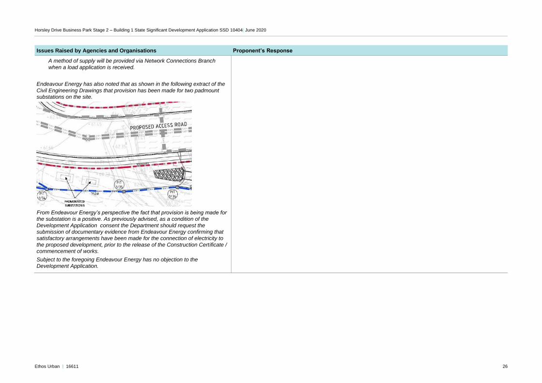
Endeavour Energy has noted the following in the EIS:
Endeavour Energy’s adjoining easement is for 132,000 volt / 132 kilovolt (kV) high voltage overhead power lines, overhead earth cables and overhead pilot
cables (carrying protection signals or communications between substations).
As previously advised, if any proposed works (other than those approved /
certified by Endeavour Energy’s Network Connections Branch as part of an
enquiry / application for load or asset relocation project) will encroach / affect Endeavour Energy’s easements or protected assets, contact must first be made with the Endeavour Energy’s Easements Officer.
Endeavour Energy’s Asset Planning & Performance Branch has provided the following advice:
There have previously been enquiries for industrial subdivision and establishment of warehouse(s) in the highlighted area included in this EIS but to date these have not proceeded.
Endeavour Energy has spare capacity from the nearby West Wetherill Park Zone Substation from which a new 11 kV feeder may be required
depending on the size and type of the load application.
The development may require the existing overhead power lines to be undergrounded along the frontage.
• Noted.
• A submission for power will be made to Endeavor Energy prior to commencement of work.
Horsley Drive Business Park Stage 2 – Building 1 State Significant Development Application SSD 10404| June 2020
Ethos Urban | 16611 26
Issues Raised by Agencies and Organisations Proponent’s Response
A method of supply will be provided via Network Connections Branch
when a load application is received.
Endeavour Energy has also noted that as shown in the following extract of the
Civil Engineering Drawings that provision has been made for two padmount substations on the site.
From Endeavour Energy’s perspective the fact that provision is being made for the substation is a positive. As previously advised, as a condition of the
Development Application consent the Department should request the submission of documentary evidence from Endeavour Energy confirming that satisfactory arrangements have been made for the connection of electricity to
the proposed development, prior to the release of the Construction Certificate /
commencement of works.
Subject to the foregoing Endeavour Energy has no objection to the