Page 1
Boardman to Hemingway Transmission Line Project Exhibit X
APPLICATION FOR SITE CERTIFICATE
ATTACHMENT X-5 AERIAL MAPS SHOWING NOISE SENSITIVE RECEPTORS PREDICTED TO EXCEED AMBIENT DEGRADATION STANDARD
Page 2
Table of Contents
B2HAPP Attachment X-5 Maps - All NSRs and NSR Exceedances 2
1 Extracted pages from B2HAPPDoc3-41 ASC 24_Exhibit X_Noise_ASC 2018-09-28 2
2 B2HAPP Attachment NSR Map 3
B2HAPPDoc3-58 ASC Exhibit X - Errata Info 2019-03-28 45
B2HAPP Attachment X-5_Attachment 1 Maps - DPO Response Additional NSR Exceedances 50
Page 3
! !
!
!
!
!
!
!
!
!H
!H
NAVAL WEAPONSSYSTEMS TRAININGFACILITY (NWSTF)
BOARDMAN
UMATILLADEPOT
Pendleton
Heppner
BoardmanHermiston
Stanfield
Cecil
Echo
Ione
Rieth
Lexington
PilotRock
§̈¦82
§̈¦84
§̈¦84
£¤395
£¤395
ST19
ST207
ST207
ST74
ST14
ST74
McKayReservoir
ColumbiaRiver
Cold SpringsReservoir
G I L L I A M
U M A T I L L A
K L I C K I T A T
West of BombingRange Road
Alternatives 1/2
ProposedRoute
LonghornStation
60
40
20
10
30
50
1
23
4
Map Index
Location Map (Map #)Source(s): BLM, IPC, Esri
Z:\UtilServ\Boardman_Hemingway\Reports\002_Oregon_Energy_Siting_Council\03_FinalASC\Exhibits\X_Noise\Maps\Attachment X-1\Index_Morrow.mxd
Map Index
!F0 5
Miles
Morrow County
O R E G O N
MapArea
Boardman to Hemingway Transmission Line ProjectApplication for Site Certificate
Attachment X-1Noise Sensitive Receptors
Page 4
M O R R O WM O R R O W
C O U N T YC O U N T Y
West ExtWest ExtIrrigation CanalIrrigation Canal
West ExtWest ExtIrrigation CanalIrrigation Canal
Coyote SpringCoyote SpringSec.Sec.1212
Sec.Sec.1313
Sec.Sec.88
Sec.Sec.77
Sec.Sec.1717
Sec.Sec.1818
4N4N25E25E
4N4N26E26E
ProposedRoute
Bonneville PowerBonneville PowerAdministrationAdministrationBoardman-Boardman TapBoardman-Boardman Tap
Umatilla ElectricUmatilla ElectricCoop AssociationCoop AssociationCoyote Springs-TapCoyote Springs-Tap
Bonneville PowerBonneville PowerAdministrationAdministrationMcNary-SantiamMcNary-Santiam
Bonneville PowerBonneville PowerAdministrationAdministrationMcNary-SlattMcNary-Slatt
Bonneville PowerBonneville PowerAdministrationAdministration
McNary-BoardmanMcNary-Boardman
Umatilla ElectricUmatilla ElectricCoop AssociationCoop AssociationBoardman-Coyote SpringsBoardman-Coyote Springs
Bonneville PowerBonneville PowerAdministrationAdministrationBoardman-TapBoardman-Tap
Frontage RdFrontage Rd
Root
Ln
Root
Ln
BBoommbbiinnggRRa an ng ge e
R Rd d
BBoo aa
rr ddmm aa nn CC aa nn aa ll RR dd
Wi lson Rd SEWilson Rd SE
BB oo aa rr dd mm aa nn CC aa nn aa ll RR dd
£¤730
§̈¦84
§̈¦84
Union Paci f ic Rai lroad
Union Paci f ic Rai lroad
Union Paci f ic Rai lroad
Union Paci f ic Rai lroad
NSR-1
NSR-2ExistingSubstation
1
MUAMO-01
Noise SensitiveReceptors
!! No Exceedance
Project Features
Site Boundary
Transmission CenterlineMileposts
!H Mile!( Tenth-mile
Land Status
Bureau of LandManagement
Bureau of Reclamation
Private
Other Features
100-foot Contours
! !Existing TransmissionLines
Interstate
Highway
Road
Railroad
Stream
Source(s): IPC, ODOT, USDA, USGS, Ventyx, Esri
Z:\UtilServ\Boardman_Hemingway\Reports\002_Oregon_Energy_Siting_Council\03_FinalASC\Exhibits\X_Noise\Maps\Attachment X-1\ATTACHMENT X-1 Noise_rev 20180622.mxd
O R E G O N
MapArea
Map 1
!F0 1,000
Feet
Boardman to Hemingway Transmission Line ProjectApplication for Site Certificate
Morrow County
Attachment X-1Noise Sensitive Receptors
Page 5
M O R R O WM O R R O W
C O U N T YC O U N T Y
Little JuniperLittle JuniperCanyonCanyon
StrawberryStrawberryCanyonCanyon
Sec.Sec.22
Sec.Sec.11
Sec.Sec.66
1N1N25E25E
1N1N26E26E
Proposed Route
Li tt le Juniper LnLi tt le Juniper Ln
LL ii tt tt ll ee JJ uu nn ii pp ee rr LL nn
GGr ri ieebb- -WW
o oo od dR Rd d
Bom
bing
Ran
ge R
dBo
mbi
ng R
ange
Rd
Barak Mart in Rd NBarak Mart in Rd N
NSR-3
18
Noise SensitiveReceptors
!! No Exceedance
Project Features
Site Boundary
Transmission CenterlineMileposts
!H Mile!( Tenth-mile
Land Status
Private
Other Features
100-foot Contours
Road
Stream
Source(s): IPC, ODOT, USDA, USGS, Ventyx, Esri
Z:\UtilServ\Boardman_Hemingway\Reports\002_Oregon_Energy_Siting_Council\03_FinalASC\Exhibits\X_Noise\Maps\Attachment X-1\ATTACHMENT X-1 Noise_rev 20180622.mxd
O R E G O N
MapArea
Map 2
!F0 1,000
Feet
Boardman to Hemingway Transmission Line ProjectApplication for Site Certificate
Morrow County
Attachment X-1Noise Sensitive Receptors
Page 6
M O R R O WM O R R O W
C O U N T YC O U N T Y
MuleMuleHollowHollow
LittleLittleButter CreekButter Creek
ButterButterCreekCreek
Sec.Sec.1111
Sec.Sec.99
Sec.Sec.1010
1N1N27E27E
ProposedRoute
LL ii tt tt ll ee BB uu tt tt ee rr CC rr ee ee kk RR dd
NN aa tt ll FF oo rr ee ss tt DD ee vv ee ll oo pp RR oo aa dd 77 44 00 RR dd
BBuut tt teer rC Cr re ee ek kRRdd
NNaattllFFoorreessttDDeevv ee ll oo pp RR oo aa dd 77 44 00 RR dd
BBi ig gBBuut tt teer rCCrreeeekk
LLnn
NSR-4
NSR-5
29
28
27
MUAMO-03
Noise SensitiveReceptors
!! No Exceedance
Project Features
Site Boundary
Transmission CenterlineMileposts
!H Mile!( Tenth-mile
Land Status
Private
Other Features
100-foot Contours
Road
Stream
Source(s): IPC, ODOT, USDA, USGS, Ventyx, Esri
Z:\UtilServ\Boardman_Hemingway\Reports\002_Oregon_Energy_Siting_Council\03_FinalASC\Exhibits\X_Noise\Maps\Attachment X-1\ATTACHMENT X-1 Noise_rev 20180622.mxd
O R E G O N
MapArea
Map 3
!F0 1,000
Feet
Boardman to Hemingway Transmission Line ProjectApplication for Site Certificate
Morrow County
Attachment X-1Noise Sensitive Receptors
Page 7
M O R R O WM O R R O W
C O U N T YC O U N T Y
MuleMuleHollowHollow
ButterButterCreekCreek
AyersAyersCanyonCanyon
MatlockMatlockCanyonCanyon
Ayers CanyonAyers Canyon
Sec.Sec.2222
Sec.Sec.2929
Sec.Sec.2727
Sec.Sec.2828
1N1N28E28E
ProposedRoute
NNaattl lFFoorreesst tDDeevveel looppRRooaadd
882277RRdd
BB ii gg BB uu tt tt ee rr CC rr ee ee kk LL nn
Big Butter Creek LnBig Butter Creek Ln
NSR-6
35
34
3332
MUAMO-04
Noise SensitiveReceptors
!! No Exceedance
Project Features
Site Boundary
Transmission CenterlineMileposts
!H Mile!( Tenth-mile
Land Status
Private
Other Features
100-foot Contours
Road
Stream
Source(s): IPC, ODOT, USDA, USGS, Ventyx, Esri
Z:\UtilServ\Boardman_Hemingway\Reports\002_Oregon_Energy_Siting_Council\03_FinalASC\Exhibits\X_Noise\Maps\Attachment X-1\ATTACHMENT X-1 Noise_rev 20180622.mxd
O R E G O N
MapArea
Map 4
!F0 1,000
Feet
Boardman to Hemingway Transmission Line ProjectApplication for Site Certificate
Morrow County
Attachment X-1Noise Sensitive Receptors
Page 8
!
!
!
!
!
!
!
!H
!H
!H
U M AT I L L AR E S E R VAT I O N
M O R R O W
U N I O N
U M AT I L L AN AT ' L F O R E S T§̈¦84
£¤395
ST207
ST237
ST82
ST74
ST244
ST11
ST204
§̈¦84
§̈¦84£¤395
Pendleton
Heppner LaGrande
Hermiston
Stanfield
Echo
Rieth
PilotRock
Hilgard IslandCity
McKayReservoir
Cold SpringsReservoir
ProposedRoute
40
70
100
30
9065 7
8
9 10
Map IndexLocation Map (Map #)
Source(s): BLM, IPC, Esri
Z:\UtilServ\Boardman_Hemingway\Reports\002_Oregon_Energy_Siting_Council\03_FinalASC\Exhibits\X_Noise\Maps\Attachment X-1\Index_Umatilla.mxd
Map Index
!F0 5
Miles
Umatilla County
O R E G O N
MapArea
Boardman to Hemingway Transmission Line ProjectApplication for Site Certificate
Attachment X-1Noise Sensitive Receptors
Page 9
U M A T I L L AU M A T I L L A
C O U N T YC O U N T Y
ButterButterCreekCreek
East ForkEast ForkButter CreekButter Creek
NelsonNelsonCanyonCanyon
WebbWebbSloughSlough
Sec.Sec.88
Sec.Sec.1010
Sec.Sec.99
2S2S30E30E
ProposedRoute
CC uu ll vv ee rr tt BB rr ii dd gg ee LL nn
GGuu rr
dd aann ee RR dd
GG uu rr dd aa nn ee RR dd
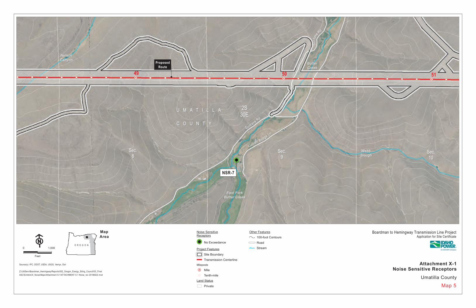
NSR-7
49 5150
Noise SensitiveReceptors
!! No Exceedance
Project Features
Site Boundary
Transmission CenterlineMileposts
!H Mile!( Tenth-mile
Land Status
Private
Other Features
100-foot Contours
Road
Stream
Source(s): IPC, ODOT, USDA, USGS, Ventyx, Esri
Z:\UtilServ\Boardman_Hemingway\Reports\002_Oregon_Energy_Siting_Council\03_FinalASC\Exhibits\X_Noise\Maps\Attachment X-1\ATTACHMENT X-1 Noise_rev 20180622.mxd
O R E G O N
MapArea
Map 5
!F0 1,000
Feet
Boardman to Hemingway Transmission Line ProjectApplication for Site Certificate
Umatilla County
Attachment X-1Noise Sensitive Receptors
Page 10
U M A T I L L AU M A T I L L A
C O U N T YC O U N T Y
BridgeBridgeCreekCreek
West BirchWest BirchCreekCreek
BearBearCreekCreek
Sec.Sec.1111
Sec.Sec.1212
2S2S31E31E
2S2S32E32E
ProposedRoute
BB ee aa rr CC rr ee ee kk RR dd
YY eell ll oo
wwJJ aa
cc kkee tt
RRdd
NSR-8
NSR-9
NSR-10
NSR-11
NSR-5002
616059
Noise Sensitive Receptors
!! Predicted Exceedance
Project Features
Site Boundary
Transmission CenterlineMileposts
!H Mile!( Tenth-mile
Land Status
Bureau of LandManagement
Private
Other Features
100-foot Contours
Road
Stream
Source(s): IPC, ODOT, USDA, USGS, Ventyx, Esri
Z:\UtilServ\Boardman_Hemingway\Reports\002_Oregon_Energy_Siting_Council\03_FinalASC\Exhibits\X_Noise\Maps\Attachment X-1\ATTACHMENT X-1 Noise_rev 20180622.mxd
O R E G O N
MapArea
Map 6
!F0 1,000
Feet
Boardman to Hemingway Transmission Line ProjectApplication for Site Certificate
Umatilla County
Attachment X-1Noise Sensitive Receptors
Page 11
U M A T I L L AU M A T I L L A
C O U N T YC O U N T Y
East BirchEast BirchCreekCreek
East BirchEast BirchCreekCreek
California GulchCalifornia Gulch
East BirchEast BirchCreekCreek
Sec.Sec.1212
Sec.Sec.1010
Sec.Sec.1111
2S2S33E33E
2S2S32E32E
ProposedRoute
EEBBiirrcchh
CC rree eekk RRdd
EE BB ii rr cc hh CC rr ee ee kk RR dd
NSR-12
NSR-13
NSR-14
NSR-15
NSR-16
67
66
65
64
Noise SensitiveReceptors
!! No Exceedance
Project Features
Site Boundary
Transmission CenterlineMileposts
!H Mile!( Tenth-mile
Land Status
Private
Other Features
100-foot Contours
Road
Stream
Source(s): IPC, ODOT, USDA, USGS, Ventyx, Esri
Z:\UtilServ\Boardman_Hemingway\Reports\002_Oregon_Energy_Siting_Council\03_FinalASC\Exhibits\X_Noise\Maps\Attachment X-1\ATTACHMENT X-1 Noise_rev 20180622.mxd
O R E G O N
MapArea
Map 7
!F0 1,000
Feet
Boardman to Hemingway Transmission Line ProjectApplication for Site Certificate
Umatilla County
Attachment X-1Noise Sensitive Receptors
Page 12
U M A T I L L AU M A T I L L A
C O U N T YC O U N T Y
SevenmileSevenmileCreekCreek
Wood HollowWood Hollow McKay CreekMcKay Creek
McKayMcKayCreekCreek
RailRailCreekCreek
LittleLittleRail CreekRail Creek
Sec.Sec.2424
Sec.Sec.2020
Sec.Sec.1919
1S1S33E33E
1S1S34E34E Proposed
Route
Co 1050 Rd
Co 1050 Rd
MMccKKaayy
CCrreeeekkRRddNSR-17
76
MUAUM-06
Noise SensitiveReceptors
!! No Exceedance
Project Features
Site Boundary
Transmission CenterlineMileposts
!H Mile!( Tenth-mile
Land Status
Private
Other Features
100-foot Contours
Road
Stream
Source(s): IPC, ODOT, USDA, USGS, Ventyx, Esri
Z:\UtilServ\Boardman_Hemingway\Reports\002_Oregon_Energy_Siting_Council\03_FinalASC\Exhibits\X_Noise\Maps\Attachment X-1\ATTACHMENT X-1 Noise_rev 20180622.mxd
O R E G O N
MapArea
Map 8
!F0 1,000
Feet
Boardman to Hemingway Transmission Line ProjectApplication for Site Certificate
Umatilla County
Attachment X-1Noise Sensitive Receptors
Page 13
U M A T I L L AU M A T I L L A
C O U N T YC O U N T Y
LittleLittleRail CreekRail Creek
RailRailCreekCreek
CalamityCalamityCreekCreek
Green SpringGreen Spring
Marlin SpringMarlin Spring
Sec.Sec.99
Sec.Sec.1010Sec.Sec.
88
1S1S34E34E
ProposedRoute
DD rr ii vv eeww aa yy
Ross RdRoss Rd
Co 1
046
RdCo
104
6 Rd
CCoo11004466
RRdd
NSR-18
NSR-19
80
7978
MUAUM-07
Noise SensitiveReceptors
!! No Exceedance
Project Features
Site Boundary
Transmission CenterlineMileposts
!H Mile!( Tenth-mile
Land Status
Private
Other Features
100-foot Contours
Road
Stream
Source(s): IPC, ODOT, USDA, USGS, Ventyx, Esri
Z:\UtilServ\Boardman_Hemingway\Reports\002_Oregon_Energy_Siting_Council\03_FinalASC\Exhibits\X_Noise\Maps\Attachment X-1\ATTACHMENT X-1 Noise_rev 20180622.mxd
O R E G O N
MapArea
Map 9
!F0 1,000
Feet
Boardman to Hemingway Transmission Line ProjectApplication for Site Certificate
Umatilla County
Attachment X-1Noise Sensitive Receptors
Page 14
U M A T I L L AU M A T I L L A
C O U N T YC O U N T Y
Red SpringRed SpringCanyonCanyon
Bell CowBell CowCreekCreek
LittleLittleBeaver CreekBeaver Creek
Sec.Sec.1212
Sec.Sec.88Sec.Sec.
77Sec.Sec.
99
Sec.Sec.1616
Sec.Sec.1818
Sec.Sec.1717
1S1S34E34E
1S1S35E35EProposed
Route
CC oo 11 00 44 66 RR dd
NSR-20
83
82
Noise SensitiveReceptors
!! No Exceedance
Project Features
Site Boundary
Transmission CenterlineMileposts
!H Mile!( Tenth-mile
Land Status
Indian Reservation
Private
Other Features
100-foot Contours
Road
Stream
Source(s): IPC, ODOT, USDA, USGS, Ventyx, Esri
Z:\UtilServ\Boardman_Hemingway\Reports\002_Oregon_Energy_Siting_Council\03_FinalASC\Exhibits\X_Noise\Maps\Attachment X-1\ATTACHMENT X-1 Noise_rev 20180622.mxd
O R E G O N
MapArea
Map 10
!F0 1,000
Feet
Boardman to Hemingway Transmission Line ProjectApplication for Site Certificate
Umatilla County
Attachment X-1Noise Sensitive Receptors
Page 15
!
!
!
!
!
!H
§̈¦84
ST237
ST82
ST203
ST237
ST244
§̈¦84
W A L L O W A - W H I T M A NN AT ' L F O R E S T
W A L L O W A - W H I T M A NN AT ' L F O R E S T
W A L L O W A - W H I T M A NN AT ' L F O R E S T
LaGrande
Hilgard IslandCity
Union
Telocaset
NorthPowder
ConleyLake
ShawReservoir
Thief ValleyReservoir
GoverReservoir
ProposedRoute
ProposedRoute
Morgan LakeAlternative
B A K E R
U M A T I L L A
U N I O N
W A L L O W A
130
70
100
10
110
120
15
17
11
12
13
14
16
18
19
20
Map IndexLocation Map (Map #)
Source(s): BLM, IPC, Esri
Z:\UtilServ\Boardman_Hemingway\Reports\002_Oregon_Energy_Siting_Council\03_FinalASC\Exhibits\X_Noise\Maps\Attachment X-1\Index_Union.mxd
Map Index
!F0 5
Miles
Union County
O R E G O N
MapArea
Boardman to Hemingway Transmission Line ProjectApplication for Site Certificate
Attachment X-1Noise Sensitive Receptors
Page 16
U M A T I L L AU M A T I L L A
C O U N T YC O U N T Y
U N I O NU N I O N
C O U N T YC O U N T Y
SpringSpringCreekCreek DryDry
CreekCreek
ButcherButcherCreekCreek
MeachamMeachamCreekCreek
BeaverBeaverCreekCreek
Sec.Sec.3434
Sec.Sec.3535
Sec.Sec.3636
1S1S35E35E
2S2S35E35E
ProposedRoute
Bonneville PowerBonneville PowerAdministrationAdministrationRoundup-La GrandeRoundup-La Grande
NN aa tt ll FF oo rr ee sstt DD eevv ee ll oo pp RR oo aa dd 44 00 00RR
dd
NN FF DD 33 88 11 RR dd
FF ll aa tt LL aa kk eeLL oo oo kk oo uu tt
RRdd
NFD
382
RdNF
D 38
2 Rd
N NF FD D3 3
8811 RRdd
OOll dd
UUSS
HHww
yy3300
SS uu mmmm ii tt RR dd
§̈¦84UU nn ii oo nn PP aa cc ii ff ii cc RRaaii ll rr ooaadd
UUnniioonnPPaacciiffiicc
RRaaii ll rrooaadd
NSR-21
NSR-22
NSR-23
NSR-2488
87
89
Noise SensitiveReceptors
!! No Exceedance
Project Features
Site Boundary
Transmission CenterlineMileposts
!H Mile!( Tenth-mile
Land Status
Forest Service
Private
State or Local
State or Local Parks andRecreation or Wildlife
Other Features
100-foot Contours
! !Existing TransmissionLines
Interstate
Road
Railroad
Stream
Source(s): IPC, ODOT, USDA, USGS, Ventyx, Esri
Z:\UtilServ\Boardman_Hemingway\Reports\002_Oregon_Energy_Siting_Council\03_FinalASC\Exhibits\X_Noise\Maps\Attachment X-1\ATTACHMENT X-1 Noise_rev 20180622.mxd
O R E G O N
MapArea
Map 11
!F0 1,000
Feet
Boardman to Hemingway Transmission Line ProjectApplication for Site Certificate
Union County
Attachment X-1Noise Sensitive Receptors
Page 17
U N I O NU N I O N
C O U N T YC O U N T Y
Dry CreekDry Creek
SpringSpringCreekCreek
CaliforniaCaliforniaGulchGulch
W A L L O W A - W H I T M A NW A L L O W A - W H I T M A N
N A T I O N A L F O R E S TN A T I O N A L F O R E S T
Sec.Sec.88
Sec.Sec.1212
2S2S36E36E
2S2S35E35E
ProposedRoute
Bonneville PowerBonneville PowerAdministrationAdministrationRoundup-La GrandeRoundup-La Grande
OOlldd EEmmiiggrr aannt tHH
ii ll ll SS ccee nn ii cc FFRR NNTTGG RRdd
§̈¦84
UUnniioonnPPaacciiffiicc
RRaaiillrrooaadd
Union Pacif ic Rail road
Union Pacif ic Rail road
NSR-25
NSR-26
92
91
Noise SensitiveReceptors
!! No Exceedance
Project Features
Site Boundary
Transmission CenterlineMileposts
!H Mile!( Tenth-mile
Land Status
Bureau of LandManagement
Forest Service
Private
State or Local Parks andRecreation or Wildlife
Other Features
100-foot Contours
! !Existing TransmissionLines
Interstate
Road
Railroad
Stream
Source(s): IPC, ODOT, USDA, USGS, Ventyx, Esri
Z:\UtilServ\Boardman_Hemingway\Reports\002_Oregon_Energy_Siting_Council\03_FinalASC\Exhibits\X_Noise\Maps\Attachment X-1\ATTACHMENT X-1 Noise_rev 20180622.mxd
O R E G O N
MapArea
Map 12
!F0 1,000
Feet
Boardman to Hemingway Transmission Line ProjectApplication for Site Certificate
Union County
Attachment X-1Noise Sensitive Receptors
Page 18
U N I O NU N I O N
C O U N T YC O U N T YGrandeGrande
Ronde RiverRonde River
RockRockCreekCreek
SpringSpringCreekCreek
W A L L O W A - W H I T M A NW A L L O W A - W H I T M A N
N A T I O N A L F O R E S TN A T I O N A L F O R E S T
Sec.Sec.11
Sec.Sec.22
Sec.Sec.66
2S2S36E36E 2S2S
37E37E
3S3S36E36E 3S3S
37E37E
MorganLake
Alternative
Proposed Route
Bonneville PowerBonneville PowerAdministrationAdministrationRoundup-La GrandeRoundup-La Grande
MMiillll CCaannyyoonnRRdd
RR oo cc kk CC rr ee ee kk FF rr oo nn tt aa gg ee RR dd
ST244
ST244
§̈¦84
NSR-29
100
99
98
Noise SensitiveReceptors
!! No Exceedance
Project Features
Site Boundary
Transmission Centerline
AlternativeMileposts
!H Mile!( Tenth-mile
Land Status
Forest Service
Private
State or Local Parks andRecreation or Wildlife
Other Features
100-foot Contours
! !Existing TransmissionLines
Interstate
Road
Stream
Source(s): IPC, ODOT, USDA, USGS, Ventyx, Esri
Z:\UtilServ\Boardman_Hemingway\Reports\002_Oregon_Energy_Siting_Council\03_FinalASC\Exhibits\X_Noise\Maps\Attachment X-1\ATTACHMENT X-1 Noise_rev 20180622.mxd
O R E G O N
MapArea
Map 13
!F0 1,000
Feet
Boardman to Hemingway Transmission Line ProjectApplication for Site Certificate
Union County
Attachment X-1Noise Sensitive Receptors
Page 19
LaLaGrandeGrande
MorganMorganLakeLake
U N I O NU N I O N
C O U N T YC O U N T Y
MillMillCreekCreek
SheepSheepCreekCreek
DealDealCreekCreek
MillMillCreekCreek
Sec.Sec.1111
Sec.Sec.1212
Sec.Sec.1414
Sec.Sec.1313
Sec.Sec.77
Sec.Sec.1818
LA GRANDE
LA GRANDE
CITY LIMITS
CITY LIMITS
3S3S37E37E
3S3S38E38E
Morgan LakeAlternative
ProposedRoute
Bonneville PowerBonneville PowerAdministrationAdministration
Roundup-La GrandeRoundup-La Grande
33rrdd
SStt
G AveG Ave
Woo
d Rd
Woo
d Rd
CCee dd
aa rrSS
tt
2nd
St2n
d St
C AveC Ave
6th
St6t
h St
S Skk yyllii nn ee LL nn
H AveH Ave
B AveB Ave
WWoooodd
RRdd
MMoo rr
gg aann
LL aakk ee
RRdd
MMaa rr
vv iinn
RRdd
NSR-36
NSR-37
NSR-38
NSR-39
NSR-40NSR-41
NSR-42
NSR-43NSR-44
NSR-45
NSR-46
NSR-47
NSR-48
NSR-49
NSR-50
NSR-53NSR-54
105
104
6
106
Noise SensitiveReceptors
!! No Exceedance
Project Features
Site Boundary
Transmission Centerline
AlternativeMileposts
!H Mile!( Tenth-mile
Land Status
Private
Other Features
100-foot Contours
! !Existing TransmissionLines
Road
Stream
City Limits
Source(s): IPC, ODOT, USDA, USGS, Ventyx, Esri
Z:\UtilServ\Boardman_Hemingway\Reports\002_Oregon_Energy_Siting_Council\03_FinalASC\Exhibits\X_Noise\Maps\Attachment X-1\ATTACHMENT X-1 Noise_rev 20180622.mxd
O R E G O N
MapArea
Map 14
!F0 1,000
Feet
Boardman to Hemingway Transmission Line ProjectApplication for Site Certificate
Union County
Attachment X-1Noise Sensitive Receptors
Page 20
MorganMorganLakeLake
U N I O NU N I O N
C O U N T YC O U N T Y
MillMillCreekCreek
SheepSheepCreekCreek
Sec.Sec.2323
Sec.Sec.2424
Sec.Sec.1919
3S3S37E37E 3S3S
38E38E
Proposed RouteMorgan LakeAlternative MM oo rr gg aa nn LL aa kk ee RR dd
WWoooodd
RRdd
MM ii ll ll CC aa nn yy oo nn RR dd
GGllaassssHHiillll RRdd
NSR-51
NSR-52
NSR-55
NSR-56
NSR-119
NSR-115
NSR-5004
7
108
107
Noise Sensitive Receptors
!! Predicted Exceedance
!! No Exceedance
Project Features
Site Boundary
Transmission Centerline
AlternativeMileposts
!H Mile!( Tenth-mile
Land Status
Private
Other Features
100-foot Contours
Road
Stream
Source(s): IPC, ODOT, USDA, USGS, Ventyx, Esri
Z:\UtilServ\Boardman_Hemingway\Reports\002_Oregon_Energy_Siting_Council\03_FinalASC\Exhibits\X_Noise\Maps\Attachment X-1\ATTACHMENT X-1 Noise_rev 20180622.mxd
O R E G O N
MapArea
Map 15
!F0 1,000
Feet
Boardman to Hemingway Transmission Line ProjectApplication for Site Certificate
Union County
Attachment X-1Noise Sensitive Receptors
Page 21
U N I O NU N I O N
C O U N T YC O U N T Y
Sec.Sec.3333
Sec.Sec.3535
Sec.Sec.3434
3S3S38E38E
4S4S38E38EProposed Route
Idaho Power CoIdaho Power CoQuartz-LaQuartz-LaGrandeGrande
Foothi ll RdFoothi ll Rd
BBuu ss
hh nnee ll
llRR
dd
§̈¦84
NSR-57
NSR-58
NSR-59
NSR-60
111
Noise SensitiveReceptors
!! No Exceedance
Project Features
Site Boundary
Transmission CenterlineMileposts
!H Mile!( Tenth-mile
Land Status
Private
State or Local Parks andRecreation or Wildlife
Other Features
100-foot Contours
! !Existing TransmissionLines
Interstate
RoadSource(s): IPC, ODOT, USDA, USGS, Ventyx, Esri
Z:\UtilServ\Boardman_Hemingway\Reports\002_Oregon_Energy_Siting_Council\03_FinalASC\Exhibits\X_Noise\Maps\Attachment X-1\ATTACHMENT X-1 Noise_rev 20180622.mxd
O R E G O N
MapArea
Map 16
!F0 1,000
Feet
Boardman to Hemingway Transmission Line ProjectApplication for Site Certificate
Union County
Attachment X-1Noise Sensitive Receptors
Page 22
U N I O NU N I O N
C O U N T YC O U N T Y
Sec.Sec.22
Sec.Sec.33
Sec.Sec.44
Sec.Sec.99
Sec.Sec.1111
Sec.Sec.1010
4S4S38E38EMorgan Lake
Alternative
ProposedRoute
Idaho Power CoIdaho Power CoQuartz-La GrandeQuartz-La Grande
Pier
ce R
dPi
erce
Rd
Foothi ll RdFoothi ll Rd
§̈¦84
NSR-61
NSR-62
NSR-63
NSR-132113
12
112
MUAUN-02
Noise SensitiveReceptors
!! No Exceedance
Project Features
Site Boundary
Transmission Centerline
AlternativeMileposts
!H Mile!( Tenth-mile
Land Status
Private
State or Local Parks andRecreation or Wildlife
Other Features
100-foot Contours
! !Existing TransmissionLines
Interstate
Road
Source(s): IPC, ODOT, USDA, USGS, Ventyx, Esri
Z:\UtilServ\Boardman_Hemingway\Reports\002_Oregon_Energy_Siting_Council\03_FinalASC\Exhibits\X_Noise\Maps\Attachment X-1\ATTACHMENT X-1 Noise_rev 20180622.mxd
O R E G O N
MapArea
Map 17
!F0 1,000
Feet
Boardman to Hemingway Transmission Line ProjectApplication for Site Certificate
Union County
Attachment X-1Noise Sensitive Receptors
Page 23
U N I O NU N I O N
C O U N T YC O U N T Y
Ladd CanyonLadd Canyon
LaddLaddCreekCreek
Sec.Sec.2323
Sec.Sec.2222
Sec.Sec.2424
4S4S38E38E
4S4S39E39E
Morgan LakeAlternative
ProposedRoute
Idaho Power CoIdaho Power CoQuartz-La GrandeQuartz-La Grande
LL aa dd dd CC aa nn yy oo nnRR
dd
§̈¦84
NSR-64
16 116
115
Noise SensitiveReceptors
!! No Exceedance
Project Features
Site Boundary
Transmission Centerline
AlternativeMileposts
!H Mile!( Tenth-mile
Land Status
Forest Service
Private
Other Features
100-foot Contours
! !Existing TransmissionLines
Interstate
Road
Stream
Source(s): IPC, ODOT, USDA, USGS, Ventyx, Esri
Z:\UtilServ\Boardman_Hemingway\Reports\002_Oregon_Energy_Siting_Council\03_FinalASC\Exhibits\X_Noise\Maps\Attachment X-1\ATTACHMENT X-1 Noise_rev 20180622.mxd
O R E G O N
MapArea
Map 18
!F0 1,000
Feet
Boardman to Hemingway Transmission Line ProjectApplication for Site Certificate
Union County
Attachment X-1Noise Sensitive Receptors
Page 24
U N I O NU N I O N
C O U N T YC O U N T Y CloverCloverCreekCreek
Kaylor SpringKaylor Spring
Sec.Sec.99
Sec.Sec.77
5S5S39E39E
ProposedRoute
Idaho Power CoIdaho Power CoQuartz-La GrandeQuartz-La Grande
Ladd Canyon-North Powder Rd
Ladd Canyon-North Powder Rd
§̈¦84
NSR-65
NSR-66121
120
Noise SensitiveReceptors
!! No Exceedance
Project Features
Site Boundary
Transmission CenterlineMileposts
!H Mile!( Tenth-mile
Land Status
Private
Other Features
100-foot Contours
! !Existing TransmissionLines
Interstate
Road
StreamSource(s): IPC, ODOT, USDA, USGS, Ventyx, Esri
Z:\UtilServ\Boardman_Hemingway\Reports\002_Oregon_Energy_Siting_Council\03_FinalASC\Exhibits\X_Noise\Maps\Attachment X-1\ATTACHMENT X-1 Noise_rev 20180622.mxd
O R E G O N
MapArea
Map 19
!F0 1,000
Feet
Boardman to Hemingway Transmission Line ProjectApplication for Site Certificate
Union County
Attachment X-1Noise Sensitive Receptors
Page 25
U N I O NU N I O N
C O U N T YC O U N T Y
JimmyJimmyCreekCreek
CloverCloverCreekCreek
Sec.Sec.2525
Sec.Sec.2626
Sec.Sec.2727
5S5S39E39E
Proposed Route
Oregon Trail ElectricOregon Trail ElectricConsumers Coop IncConsumers Coop Inc
North Powder-TapNorth Powder-Tap
Idaho Power CoIdaho Power CoQuartz-La GrandeQuartz-La Grande
JJ iimm
mmyy
CCrr ee
ee kkRR
dd
NSR-67
NSR-68
125
124
Noise SensitiveReceptors
!! No Exceedance
Project Features
Site Boundary
Transmission CenterlineMileposts
!H Mile!( Tenth-mile
Land Status
Private
Other Features
100-foot Contours
! !Existing TransmissionLines
Road
Stream
Source(s): IPC, ODOT, USDA, USGS, Ventyx, Esri
Z:\UtilServ\Boardman_Hemingway\Reports\002_Oregon_Energy_Siting_Council\03_FinalASC\Exhibits\X_Noise\Maps\Attachment X-1\ATTACHMENT X-1 Noise_rev 20180622.mxd
O R E G O N
MapArea
Map 20
!F0 1,000
Feet
Boardman to Hemingway Transmission Line ProjectApplication for Site Certificate
Union County
Attachment X-1Noise Sensitive Receptors
Page 26
!
!
!
!H
CONTINUEDON INSET RIGHT
BakerCity
NorthPowder
Haines
Keating
§̈¦84
§̈¦84
£¤30
£¤95
ST203
ST71
ST7
ST86
ST237
W A L L O W A - W H I T M A NN AT ' L F O R E S T
W A L L O W A - W H I T M A NN AT ' L F O R E S T
A D A M S
W A S H I N G T O N
PhillipsReservoir
Thief ValleyReservoir
BrownleeReservoir
Clear CreekReservoir
CrowReservoir
GoverReservoir
Fish Lake
LoveReservoir
U N I O N
A D A M S
W A S H I N G T O N160
130
140
170
150
21
22
23
24
25
26
Map IndexLocation Map (Map #)
Source(s): BLM, IPC, Esri
Z:\UtilServ\Boardman_Hemingway\Reports\002_Oregon_Energy_Siting_Council\03_FinalASC\Exhibits\X_Noise\Maps\Attachment X-1\Index_Baker.mxd
Map Index
!F0 5
Miles
Baker County
!
!
!
!
!
!
!
!
Lime
Nelson
RyeValley Dixie
Weatherby
Huntington
Durkee
§̈¦84
£¤30
M A L H E U R
BrownleeReservoir
190
170
180
27
O R E G O N
MapArea
Boardman to Hemingway Transmission Line ProjectApplication for Site Certificate
Attachment X-1Noise Sensitive Receptors
Page 27
!
!
!
!
!
!
!
!
!
!
!
!
!
!
!
!
!
!!
!
!
!
!
!
!
!
!
!
!
!
!
!
!
!H
CONTINUEDON INSET RIGHT
BakerCity
NorthPowder
Haines
Keating
§̈¦84
§̈¦84
£¤30
£¤95
ST203
ST71
ST7
ST86
ST237
W A L L O W A - W H I T M A NN AT ' L F O R E S T
W A L L O W A - W H I T M A NN AT ' L F O R E S T
A D A M S
W A S H I N G T O N
PhillipsReservoir
Thief ValleyReservoir
BrownleeReservoir
Clear CreekReservoir
CrowReservoir
GoverReservoir
Fish Lake
LoveReservoir
U N I O N
A D A M S
W A S H I N G T O N
New Bridge
Oxman
Pine
PleasantValley
Pocahontas
McEwen Quartz
Rock Creek
Salisbury
Bourne
Sparta
Sunset
Carson
Cornucopia
WingWingville
Homestead
Hutchinson
Halfway
Sumpter
Richland
Oxbow
Durkee
160
130
140
170
150
Map IndexLocation Map (Map #)
Source(s): BLM, IPC, Esri
Z:\UtilServ\Boardman_Hemingway\Reports\002_Oregon_Energy_Siting_Council\03_FinalASC\Exhibits\X_Noise\Maps\Attachment X-1\20190313\Index_Baker_ERRATA.mxd
Map Index
!F0 5
Miles
Baker County
!
!
!
!
!
!
!
!
Lime
Nelson
RyeValley Dixie
Weatherby
Huntington
Durkee
§̈¦84
£¤30
M A L H E U R
BrownleeReservoir
190
170
180
34
O R E G O N
MapArea
Boardman to Hemingway Transmission Line ProjectApplication for Site Certificate
Attachment X-1Noise Sensitive Receptors
ERRATA
Page 28
B A K E RB A K E R
C O U N T YC O U N T Y
BaldockBaldockSloughSlough
Sec.Sec.1313
Sec.Sec.1414
Sec.Sec.2323
Sec.Sec.2424
Sec.Sec.1818
Sec.Sec.1919
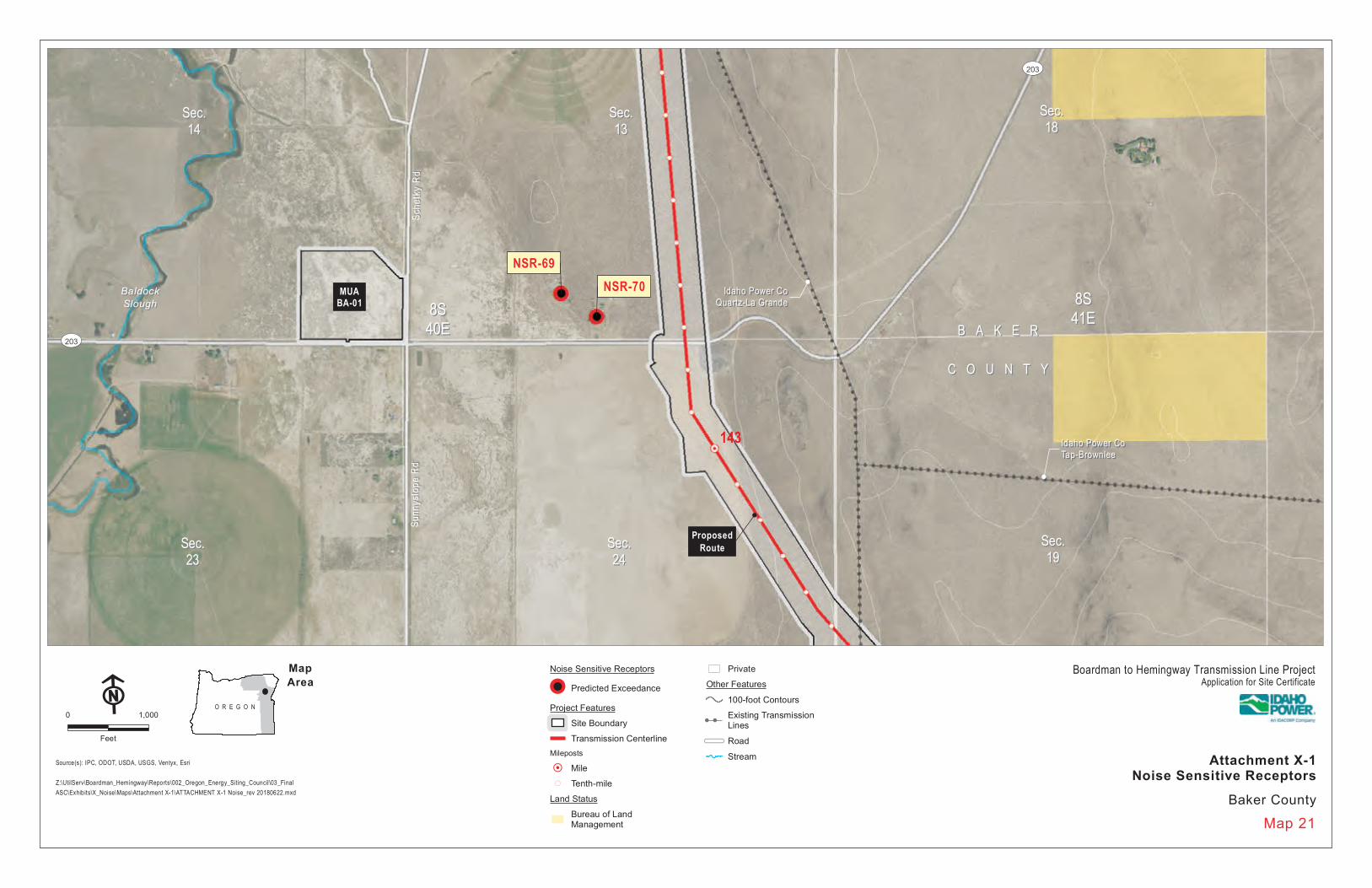
8S8S40E40E
8S8S41E41E
ProposedRoute
Idaho Power CoIdaho Power CoQuartz-La GrandeQuartz-La Grande
Idaho Power CoIdaho Power CoTap-BrownleeTap-Brownlee
Sche
tky
RdSc
hetk
y Rd
Sunn
yslo
pe R
dSu
nnys
lope
Rd
ST203
ST203
NSR-69NSR-70
143
MUABA-01
Noise Sensitive Receptors
!! Predicted Exceedance
Project Features
Site Boundary
Transmission CenterlineMileposts
!H Mile!( Tenth-mile
Land Status
Bureau of LandManagement
Private
Other Features
100-foot Contours
! !Existing TransmissionLines
Road
StreamSource(s): IPC, ODOT, USDA, USGS, Ventyx, Esri
Z:\UtilServ\Boardman_Hemingway\Reports\002_Oregon_Energy_Siting_Council\03_FinalASC\Exhibits\X_Noise\Maps\Attachment X-1\ATTACHMENT X-1 Noise_rev 20180622.mxd
O R E G O N
MapArea
Map 21
!F0 1,000
Feet
Boardman to Hemingway Transmission Line ProjectApplication for Site Certificate
Baker County
Attachment X-1Noise Sensitive Receptors
Page 29
B A K E RB A K E R
C O U N T YC O U N T Y
CorralCorralDitchDitch
Sec.Sec.2525
Sec.Sec.3030
Sec.Sec.2929
8S8S40E40E
8S8S41E41E
Proposed Route
Idaho Power CoIdaho Power CoQuartz-La GrandeQuartz-La Grande
Prowell LnProwell Ln
Sunn
yslo
pe R
dSu
nnys
lope
Rd NSR-72 NSR-71
144
Noise Sensitive Receptors
!! Predicted Exceedance
!! No Exceedance
Project Features
Site Boundary
Transmission CenterlineMileposts
!H Mile!( Tenth-mile
Land Status
Bureau of LandManagement
Private
Other Features
100-foot Contours
! !Existing TransmissionLines
Road
Stream
Source(s): IPC, ODOT, USDA, USGS, Ventyx, Esri
Z:\UtilServ\Boardman_Hemingway\Reports\002_Oregon_Energy_Siting_Council\03_FinalASC\Exhibits\X_Noise\Maps\Attachment X-1\ATTACHMENT X-1 Noise_rev 20180622.mxd
O R E G O N
MapArea
Map 22
!F0 1,000
Feet
Boardman to Hemingway Transmission Line ProjectApplication for Site Certificate
Baker County
Attachment X-1Noise Sensitive Receptors
Page 30
B A K E RB A K E R
C O U N T YC O U N T YCorralCorralDitchDitch
FlagstaffFlagstaffHillHill
FlagstaffFlagstaffGulchGulch
Sec.Sec.3636
Sec.Sec.3232
Sec.Sec.31318S8S
40E40E8S8S
41E41E
9S9S40E40E
9S9S41E41E
Proposed Route(230-kV Rebuild)
ProposedRoute
Idaho Power CoIdaho Power CoQuartz-La GrandeQuartz-La Grande
Sunn
yslo
pe R
dSu
nnys
lope
Rd
ST86
NSR-73
146
145
Noise SensitiveReceptors
!! No Exceedance
Project Features
Site Boundary
Transmission CenterlineMileposts
!H Mile!( Tenth-mile
Land Status
Bureau of LandManagement
Private
Other Features
100-foot Contours
! !Existing TransmissionLines
Road
Stream
Source(s): IPC, ODOT, USDA, USGS, Ventyx, Esri
Z:\UtilServ\Boardman_Hemingway\Reports\002_Oregon_Energy_Siting_Council\03_FinalASC\Exhibits\X_Noise\Maps\Attachment X-1\ATTACHMENT X-1 Noise_rev 20180622.mxd
O R E G O N
MapArea
Map 23
!F0 1,000
Feet
Boardman to Hemingway Transmission Line ProjectApplication for Site Certificate
Baker County
Attachment X-1Noise Sensitive Receptors
Page 31
B A K E RB A K E R
C O U N T YC O U N T Y
DryDryGulchGulch
QuartzQuartzCreekCreek
EbellEbellCreekCreek
SuttonSuttonCreekCreek
Sec.Sec.1212
Sec.Sec.77
10S10S40E40E
10S10S41E41E
ProposedRoute
Idaho Power CoIdaho Power CoQuartz-WQuartz-WJohn DayJohn Day
Idaho Power CoIdaho Power CoOntario-QuartzOntario-Quartz
Idaho Power CoIdaho Power CoQuartz-DurkeeQuartz-Durkee
Sut ton Creek Rd
Sut ton Creek Rd
WWSSuuttttoonn
CCrreeeekkR Rd d
Old Hwy 30
Old Hwy 30
OO ll dd HH ww yy 33 00
§̈¦84
§̈¦84
Union Pacif ic Rail road
Union Pacif ic Rail road
UUnniioonn
PPaacc ii ff ii cc RRaa ii ll rroo aadd
NSR-74
NSR-75
NSR-76NSR-77
NSR-78
NSR-79
NSR-80
NSR-81
ExistingSubstation
156
155
154
Noise SensitiveReceptors
!! No Exceedance
Project Features
Site Boundary
Transmission CenterlineMileposts
!H Mile!( Tenth-mile
Land Status
Bureau of LandManagement
Private
Other Features
100-foot Contours
! !Existing TransmissionLines
Interstate
Road
Railroad
Stream
Source(s): IPC, ODOT, USDA, USGS, Ventyx, Esri
Z:\UtilServ\Boardman_Hemingway\Reports\002_Oregon_Energy_Siting_Council\03_FinalASC\Exhibits\X_Noise\Maps\Attachment X-1\ATTACHMENT X-1 Noise_rev 20180622.mxd
O R E G O N
MapArea
Map 24
!F0 1,000
Feet
Boardman to Hemingway Transmission Line ProjectApplication for Site Certificate
Baker County
Attachment X-1Noise Sensitive Receptors
Page 32
B A K E RB A K E R
C O U N T YC O U N T Y
DryDryCreekCreek
BaiseleyBaiseleyCreekCreek
AlderAlderCreekCreek
Sec.Sec.2323
Sec.Sec.2424
Sec.Sec.1919
10S10S41E41E
10S10S42E42E
Proposed RouteIdaho Power CoIdaho Power CoQuartz-DurkeeQuartz-Durkee
Idaho Power CoIdaho Power CoOntario-QuartzOntario-Quartz
AA ll dd ee rr CC rr ee ee kk RR dd
HH ii xx oo nn RR dd
OOlldd HHwwyy 3300
§̈¦84
Union Paci f ic Rai lroad
Union Paci f ic Rai lroad
NSR-82
NSR-83
162
161
160
Noise SensitiveReceptors
!! No Exceedance
Project Features
Site Boundary
Transmission CenterlineMileposts
!H Mile!( Tenth-mile
Land Status
Bureau of LandManagement
Private
Other Features
100-foot Contours
! !Existing TransmissionLines
Interstate
Road
Railroad
Stream
Source(s): IPC, ODOT, USDA, USGS, Ventyx, Esri
Z:\UtilServ\Boardman_Hemingway\Reports\002_Oregon_Energy_Siting_Council\03_FinalASC\Exhibits\X_Noise\Maps\Attachment X-1\ATTACHMENT X-1 Noise_rev 20180622.mxd
O R E G O N
MapArea
Map 25
!F0 1,000
Feet
Boardman to Hemingway Transmission Line ProjectApplication for Site Certificate
Baker County
Attachment X-1Noise Sensitive Receptors
Page 33
B A K E RB A K E R
C O U N T YC O U N T Y
LowLowCreekCreek
KitchenKitchenCreekCreek
HillHillCreekCreek
AlderAlderCreekCreek
Sec.Sec.22
Sec.Sec.44
Sec.Sec.33
10S10S42E42E
11S11S42E42E
ProposedRoute
Idaho Power CoIdaho Power CoOntario-QuartzOntario-Quartz
Idaho Power CoIdaho Power CoQuartz-DurkeeQuartz-Durkee
HHii ll ll
CC rr ee ee kkRR
dd
OO ll dd HH ww yy 33 00
OOlldd HHwwyy 3300
§̈¦84
§̈¦84
UU nn ii oo nn PP aa cc ii ff ii cc RR aa ii ll rr oo aa dd
Union Pacif ic Rail road
Union Pacif ic Rail roadNSR-84
167
166
MUABA-03
Noise SensitiveReceptors
!! No Exceedance
Project Features
Site Boundary
Transmission CenterlineMileposts
!H Mile!( Tenth-mile
Land Status
Bureau of LandManagement
Private
Other Features
100-foot Contours
! !Existing TransmissionLines
Interstate
Road
Railroad
Stream
Source(s): IPC, ODOT, USDA, USGS, Ventyx, Esri
Z:\UtilServ\Boardman_Hemingway\Reports\002_Oregon_Energy_Siting_Council\03_FinalASC\Exhibits\X_Noise\Maps\Attachment X-1\ATTACHMENT X-1 Noise_rev 20180622.mxd
O R E G O N
MapArea
Map 26
!F0 1,000
Feet
Boardman to Hemingway Transmission Line ProjectApplication for Site Certificate
Baker County
Attachment X-1Noise Sensitive Receptors
Page 34
B A K E RB A K E R
C O U N T YC O U N T Y
SinkerSinkerCreekCreek
PowellPowellCreekCreek
True BlueTrue BlueGulchGulch
Sec.Sec.22
Sec.Sec.11
Sec.Sec.1111
Sec.Sec.1212
Sec.Sec.66
Sec.Sec.77
12S12S42E42E 12S12S
43E43E
Proposed Route
NSR-5010
174
175
Noise Sensitive Receptors
!! Predicted Exceedance
Project Features
Site Boundary
Transmission CenterlineMileposts
!H Mile!( Tenth-mile
Land Status
Bureau of LandManagement
Private
Other Features
100-foot Contours
Stream
Source(s): IPC, ODOT, USDA, USGS, Ventyx, Esri
Z:\UtilServ\Boardman_Hemingway\Reports\002_Oregon_Energy_Siting_Council\03_FinalASC\Exhibits\X_Noise\Maps\Attachment X-1\20190313\ATTACHMENT X-1 Noise_ERRATA.mxd
O R E G O N
MapArea
Map 34
!F0 1,000
Feet
Boardman to Hemingway Transmission Line ProjectApplication for Site Certificate
Baker County
Attachment X-1Noise Sensitive Receptors
ERRATA
Page 35
B A K E RB A K E R
C O U N T YC O U N T Y
PowellPowellCreekCreek
DixieDixieCreekCreek
StoriesStoriesGulchGulch
BurntBurntRiverRiver
DarrenDarrenCreekCreek
WateringWateringTrough DrawTrough Draw
Caribou BarCaribou Bar
Storie GulchStorie Gulch
Sec.Sec.99
Sec.Sec.88
Sec.Sec.1010
13S13S44E44E
ProposedRoute
Idaho Power CoIdaho Power CoOntario-QuartzOntario-Quartz
Idaho Power CoIdaho Power CoDurkee-LimeDurkee-Lime
DD ii xx ii ee CC rr ee ee kk RR dd
DD ii xx ii ee CC rr ee ee kk RR dd
RRyy ee
VV aall ll ee
yyLL nn
§̈¦84
UUnn ii
oo nnPP aa cc
ii ff iicc
RR aa iill rr oo
aa dd
NSR-85
NSR-86
185
184
MUABA-05
Noise SensitiveReceptors
!! No Exceedance
Project Features
Site Boundary
Transmission CenterlineMileposts
!H Mile!( Tenth-mile
Land Status
Bureau of LandManagement
Private
Other Features
100-foot Contours
! !Existing TransmissionLines
Interstate
Road
Railroad
Stream
Source(s): IPC, ODOT, USDA, USGS, Ventyx, Esri
Z:\UtilServ\Boardman_Hemingway\Reports\002_Oregon_Energy_Siting_Council\03_FinalASC\Exhibits\X_Noise\Maps\Attachment X-1\ATTACHMENT X-1 Noise_rev 20180622.mxd
O R E G O N
MapArea
Map 27
!F0 1,000
Feet
Boardman to Hemingway Transmission Line ProjectApplication for Site Certificate
Baker County
Attachment X-1Noise Sensitive Receptors
Page 36
!
!
!
!
!
!H
!H
!H
!H
!
!
CONTINUEDON INSET RIGHT
Weiser
Payette
Vale
Emmett
Brogan
Jamieson
Westfall
Ontario
Harper
§̈¦84
§̈¦84
£¤20
£¤26
£¤30
£¤95
£¤95
£¤30
ST201
ST201
ST16
ST52
ST201
A D AC A N Y O N
G E M
B A K E R
G E M
W A S H I N G T O N
Black CanyonReservoir
PaddockValley
Reservoir
SoulenReservoir
Bully CreekReservoir
SnakeRiver
ProposedRoute
Double MountainAlternative
230
210
220
240Little Valley
Nyssa
3130
28
29
Map IndexLocation Map (Map #)
Source(s): BLM, IPC, Esri
Z:\UtilServ\Boardman_Hemingway\Reports\002_Oregon_Energy_Siting_Council\03_FinalASC\Exhibits\X_Noise\Maps\Attachment X-1\Index_Malheur.mxd
Map Index
!F0 5
Miles
Malheur County
O R E G O N
MapArea
!
Adrian
£¤95
£¤20
ST201
ST19
C A N Y O N
O W Y H E E
Lake OwyheeReservoir
SnakeRiverProposed
Route
DoubleMountain
Alternative
250
270
260
IDA
HO
OR
EG
ON
32
33
Boardman to Hemingway Transmission Line ProjectApplication for Site Certificate
Attachment X-1Noise Sensitive Receptors
Page 37
!
!
!
!
!
!H
!H
!H
!H
!
!
CONTINUEDON INSET RIGHT
Weiser
Payette
Vale
Emmett
Brogan
Jamieson
Westfall
Ontario
Harper
§̈¦84
§̈¦84
£¤20
£¤26
£¤30
£¤95
£¤95
£¤30
ST201
ST201
ST16
ST52
ST201
A D AC A N Y O N
G E M
B A K E R
G E M
W A S H I N G T O N
Black CanyonReservoir
PaddockValley
Reservoir
SoulenReservoir
Bully CreekReservoir
SnakeRiver
Proposed Route(138-kV Rebuild)
ProposedRoute
Double MountainAlternative
230
200
210
220
240Little Valley
Nyssa
35
Map IndexLocation Map (Map #)
Source(s): BLM, IPC, Esri
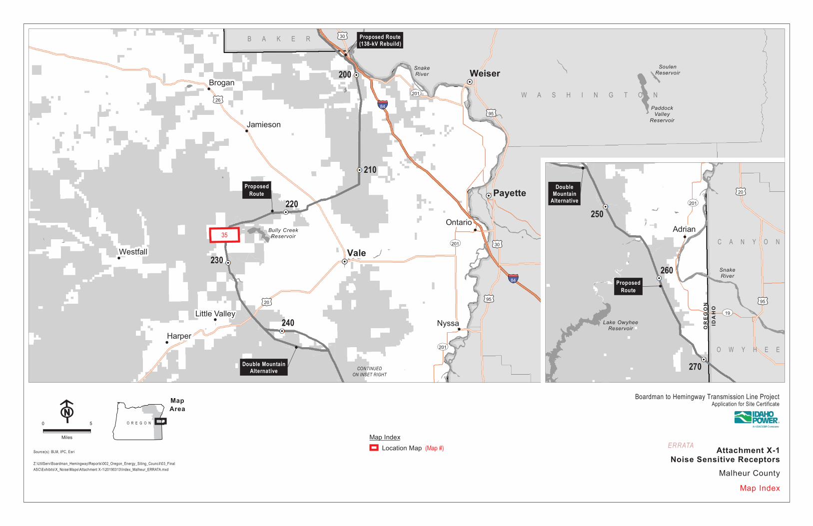
Z:\UtilServ\Boardman_Hemingway\Reports\002_Oregon_Energy_Siting_Council\03_FinalASC\Exhibits\X_Noise\Maps\Attachment X-1\20190313\Index_Malheur_ERRATA.mxd
Map Index
!F0 5
Miles
Malheur County
O R E G O N
MapArea
!
Adrian
£¤95
£¤20
ST201
ST19
C A N Y O N
O W Y H E E
Lake OwyheeReservoir
SnakeRiver
ProposedRoute
DoubleMountain
Alternative
250
270
260
IDA
HO
OR
EG
ON
Boardman to Hemingway Transmission Line ProjectApplication for Site Certificate
Attachment X-1Noise Sensitive Receptors
ERRATA
Page 38
SnakeSnakeRiverRiver
M A L H E U RM A L H E U R
C O U N T YC O U N T Y
BirchBirchCreekCreek
Sec.Sec.1818
Sec.Sec.1717
Sec.Sec.2020
Sec.Sec.44
Sec.Sec.88 Sec.Sec.
99
11N11N7W7W
15S15S45E45E
ProposedRoute (138-kV
Rebuild)
Proposed Route
Idaho Power CoIdaho Power CoOntario-QuartzOntario-Quartz
Lockett Rd
Lockett Rd
LL oo cc kk ee tt tt
RRdd
£¤30§̈¦84
§̈¦84
UUnniioonn PPaacc iiff iicc RRaaiillrrooaadd
NSR-88
NSR-89
NSR-90
199
198
1
Noise SensitiveReceptors
!! No Exceedance
Project Features
Site Boundary
Transmission CenterlineMileposts
!H Mile!( Tenth-mile
Land Status
Bureau of LandManagement
Fish and Wildlife Service
Private
State or Local
Other Features
100-foot Contours
! !Existing TransmissionLines
Interstate
Highway
Road
Railroad
Stream
Source(s): IPC, ODOT, USDA, USGS, Ventyx, Esri
Z:\UtilServ\Boardman_Hemingway\Reports\002_Oregon_Energy_Siting_Council\03_FinalASC\Exhibits\X_Noise\Maps\Attachment X-1\ATTACHMENT X-1 Noise_rev 20180622.mxd
O R E G O N
MapArea
Map 28
!F0 1,000
Feet
Boardman to Hemingway Transmission Line ProjectApplication for Site Certificate
Malheur County
Attachment X-1Noise Sensitive Receptors
Page 39
SnakeSnakeRiverRiver
M A L H E U RM A L H E U R
C O U N T YC O U N T Y
BirchBirchCreekCreek
BirchBirchCreekCreek
Sec.Sec.1616
Sec.Sec.1717
Sec.Sec.1515
11N11N7W7W
15S15S45E45E
ProposedRoute
Idaho Power CoIdaho Power CoOntario-QuartzOntario-Quartz
LL oo cc kk ee tt tt RR dd
§̈¦84
UUnniioonn PPaacciiffii cc RRaa ii ll rrooaadd
NSR-91
200
Noise SensitiveReceptors
!! No Exceedance
Project Features
Site Boundary
Transmission CenterlineMileposts
!H Mile!( Tenth-mile
Land Status
Bureau of LandManagement
Private
State or Local
Other Features
100-foot Contours
! !Existing TransmissionLines
Interstate
Road
Railroad
Stream
Source(s): IPC, ODOT, USDA, USGS, Ventyx, Esri
Z:\UtilServ\Boardman_Hemingway\Reports\002_Oregon_Energy_Siting_Council\03_FinalASC\Exhibits\X_Noise\Maps\Attachment X-1\ATTACHMENT X-1 Noise_rev 20180622.mxd
O R E G O N
MapArea
Map 29
!F0 1,000
Feet
Boardman to Hemingway Transmission Line ProjectApplication for Site Certificate
Malheur County
Attachment X-1Noise Sensitive Receptors
Page 40
M A L H E U RM A L H E U R
C O U N T YC O U N T Y
Warm SpringsWarm SpringsPump CanalPump Canal
OwyheeOwyheeCanalCanal
WillowWillowCreekCreek
WillowWillowCreekCreek
Sec.Sec.2424
Sec.Sec.2323
Sec.Sec.2626
Sec.Sec.2525
Sec.Sec.1919
17S17S44E44E
17S17S45E45E
ProposedRoute
Idaho Power CoIdaho Power CoCow Valley-JamiesonCow Valley-Jamieson
6th Ave W6th Ave WN
Road
CN
Road
C
5th Ave E5th Ave E
OOlldd OOr reeggoonn
TTrrll
£¤26
NSR-92
NSR-93NSR-94
NSR-95NSR-96
NSR-97
216
215
MUAMA-02
Noise Sensitive Receptors
!! Predicted Exceedance
Project Features
Site Boundary
Transmission CenterlineMileposts
!H Mile!( Tenth-mile
Land Status
Bureau of LandManagement
Private
Other Features
100-foot Contours
! !Existing TransmissionLines
Highway
Road
StreamSource(s): IPC, ODOT, USDA, USGS, Ventyx, Esri
Z:\UtilServ\Boardman_Hemingway\Reports\002_Oregon_Energy_Siting_Council\03_FinalASC\Exhibits\X_Noise\Maps\Attachment X-1\ATTACHMENT X-1 Noise_rev 20180622.mxd
O R E G O N
MapArea
Map 30
!F0 1,000
Feet
Boardman to Hemingway Transmission Line ProjectApplication for Site Certificate
Malheur County
Attachment X-1Noise Sensitive Receptors
Page 41
M A L H E U RM A L H E U R
C O U N T YC O U N T Y
HaymakerHaymakerGulchGulch
Vale MainVale MainCanalCanal
Sec.Sec.2929 Sec.Sec.
2727Sec.Sec.2828
17S17S44E44E
ProposedRoute
S Ro
a d D
S Ro
a d D
DDeeeerrPPaarrk kR Rd d
S Ro
ad E
S Ro
ad E
6th Ave W6th Ave W 6th Ave W6th Ave W
55 tt hh AA vv ee WW
NSR-98
NSR-99
NSR-100
NSR-101
NSR-102
NSR-103
NSR-104
NSR-105
NSR-106
NSR-107NSR-108
NSR-109
NSR-110
220219
218
217
Noise Sensitive Receptors
!! Predicted Exceedance
Project Features
Site Boundary
Transmission CenterlineMileposts
!H Mile!( Tenth-mile
Land Status
Bureau of LandManagement
Bureau of Reclamation
Private
Other Features
100-foot Contours
Road
Stream
Source(s): IPC, ODOT, USDA, USGS, Ventyx, Esri
Z:\UtilServ\Boardman_Hemingway\Reports\002_Oregon_Energy_Siting_Council\03_FinalASC\Exhibits\X_Noise\Maps\Attachment X-1\ATTACHMENT X-1 Noise_rev 20180622.mxd
O R E G O N
MapArea
Map 31
!F0 1,000
Feet
Boardman to Hemingway Transmission Line ProjectApplication for Site Certificate
Malheur County
Attachment X-1Noise Sensitive Receptors
Page 42
M A L H E U RM A L H E U R
C O U N T YC O U N T Y
Rock CabinRock CabinCreekCreek
BullyBullyCreekCreek
CottonwoodCottonwoodCreekCreek
CottonwoodCottonwoodCreekCreek
Hot SpringHot Spring
Sec.Sec.11
Sec.Sec.1212
Sec.Sec.55
Sec.Sec.66
Sec.Sec.88
Sec.Sec.77
18S18S42E42E
18S18S43E43E
ProposedRoute
BB uu ll ll yy CC rr ee ee kk RR ddBBuull ll yy CC rr ee eekk RR dd
NSR-5011 227
Noise Sensitive Receptors
!! Predicted Exceedance
Project Features
Site Boundary
Transmission CenterlineMileposts
!H Mile!( Tenth-mile
Land Status
Bureau of LandManagement
Bureau of Reclamation
Private
Other Features
100-foot Contours
Road
Stream
Source(s): IPC, ODOT, USDA, USGS, Ventyx, Esri
Z:\UtilServ\Boardman_Hemingway\Reports\002_Oregon_Energy_Siting_Council\03_FinalASC\Exhibits\X_Noise\Maps\Attachment X-1\20190313\ATTACHMENT X-1 Noise_ERRATA.mxd
O R E G O N
MapArea
Map 35
!F0 1,000
Feet
Boardman to Hemingway Transmission Line ProjectApplication for Site Certificate
Malheur County
Attachment X-1Noise Sensitive Receptors
ERRATA
Page 43
OwyheeOwyheeRiverRiver
M A L H E U RM A L H E U R
C O U N T YC O U N T Y
OwyheeOwyheeDitchDitch
OwyheeOwyheeRiverRiver
OwyheeOwyheeRiverRiver
NorthNorthCanalCanal
Hot SpringHot Spring
Rock SpringRock SpringCanyonCanyon
Sec.Sec.1414
Sec.Sec.1313
Sec.Sec.1818
21S21S45E45E
21S21S46E46E
ProposedRoute
MM ee nn dd ii oo ll aa RR dd
OO ww yy hh ee ee LL aa kk ee RR dd
RR oo cc kk SS pp rr ii nn gg ss CC aa nn yy oo nn RR dd
NSR-111
NSR-112
NSR-133
NSR-5008
NSR-5009
255
254
Noise Sensitive Receptors
!! Predicted Exceedance
Project Features
Site Boundary
Transmission CenterlineMileposts
!H Mile!( Tenth-mile
Land Status
Bureau of LandManagement
Bureau of Reclamation
Private
Other Features
100-foot Contours
Road
Stream
Source(s): IPC, ODOT, USDA, USGS, Ventyx, Esri
Z:\UtilServ\Boardman_Hemingway\Reports\002_Oregon_Energy_Siting_Council\03_FinalASC\Exhibits\X_Noise\Maps\Attachment X-1\ATTACHMENT X-1 Noise_rev 20180622.mxd
O R E G O N
MapArea
Map 32
!F0 1,000
Feet
Boardman to Hemingway Transmission Line ProjectApplication for Site Certificate
Malheur County
Attachment X-1Noise Sensitive Receptors
Page 44
M A L H E U RM A L H E U R
C O U N T YC O U N T Y
SouthSouthCanalCanal
5 7/105 7/10CanalCanal
South Alkali CreekSouth Alkali Creek
TunnelTunnelNumber 6Number 6
North AkaliNorth AkaliCreekCreek
CoyoteCoyoteGulchGulch
CoyoteCoyoteGulchGulch
North AlkaliNorth AlkaliCreekCreek
Coyote GulchCoyote Gulch
Sec.Sec.2121
Sec.Sec.2323
Sec.Sec.2222
Sec.Sec.2828
Sec.Sec.2626
Sec.Sec.2727
22S22S46E46E
ProposedRoute
Succ
or C
reek
Rd
Succ
or C
reek
Rd
Succor Creek Rd
Succor Creek Rd
CC oo yy oo tt ee GG uu ll cc hh RR dd
ST201
NSR-113
263
264
Noise Sensitive Receptors
!! Predicted Exceedance
Project Features
Site Boundary
Transmission CenterlineMileposts
!H Mile!( Tenth-mile
Land Status
Bureau of LandManagement
Bureau of Reclamation
Private
Other Features
100-foot Contours
Road
Stream
Source(s): IPC, ODOT, USDA, USGS, Ventyx, Esri
Z:\UtilServ\Boardman_Hemingway\Reports\002_Oregon_Energy_Siting_Council\03_FinalASC\Exhibits\X_Noise\Maps\Attachment X-1\ATTACHMENT X-1 Noise_rev 20180622.mxd
O R E G O N
MapArea
Map 33
!F0 1,000
Feet
Boardman to Hemingway Transmission Line ProjectApplication for Site Certificate
Malheur County
Attachment X-1Noise Sensitive Receptors
Page 45
B2H Exhibit X Errata Sheet
Dear Reader:
Exhibit X provides analysis of potential noise impacts from the Boardman to Hemingway Transmission Line Project (Project). Exhibit X identifies all noise sensitive receptors (NSRs) within one-half mile of the Site Boundary from noise-generating Project features such as the transmission line, and demonstrates that the relevant Project noise sources will not exceed the Oregon Department of Environmental Quality’s (ODEQ) maximum permissible sound level of 50 A-weighted decibels (dBA). Exhibit X also shows, for the majority of NSRs within the analysis area, that the Project will not exceed ODEQ’s ambient antidegradation standard, which prohibits new industrial noise sources located on previously unused sites from increasing ambient noise levels by more than 10 dBA. However, Idaho Power Company (IPC) estimates that, at 36 NSRs, the Project may exceed the ambient antidegradation standard during foul weather conditions that occur on average around 2 percent of the calendar year. To address these limited circumstances where an exceedance may occur, IPC requests that the Oregon Energy Facility Siting Council (EFSC or Council) authorize an exception to the Project’s compliance with the ambient antidegradation standard on the basis that such exceedances will be infrequent events and that, in all instances where the Project may exceed the ambient antidegradation standard, the noise generated by the Project is below the maximum permissible nighttime sound level (50 dBA). Alternatively, IPC requests that the Council grant a variance on the basis that requiring the Project to strictly comply with the ODEQ Noise Rules is unreasonable and likely to make the Project unpermittable.
The Applicant submitted its final Application for Site Certification on October 3, 2018. Subsequently, the Oregon Department of Energy requested certain additional information about the Project pursuant to Oregon Administrative Rule (OAR) 345-015-0190(9). This errata sheet provides the requested information—which may include corrections to the exhibit text, tables, figures, and/or proposed conditions—as it relates to Exhibit X.
As you read this exhibit, please keep in mind that any additional information identified in this errata sheet shall prevail over the contents of the exhibit document itself.
Additional Information Provided for Exhibit X
Page # Section # Description of Change(s) Made
Map 34 and Map 35 Attachment X-5 Map 34 and Map 35 added to Attachment X-5
showing noise sensitive receptors NSR-5010 and NSR-5011.
Page 46
!
!
!
!
!
!
!
!
!
!
!
!
!
!
!
!
!
!!
!
!
!
!
!
!
!
!
!
!
!
!
!
!
!H
CONTINUEDON INSET RIGHT
BakerCity
NorthPowder
Haines
Keating
§̈¦84
§̈¦84
£¤30
£¤95
ST203
ST71
ST7
ST86
ST237
W A L L O W A - W H I T M A NN AT ' L F O R E S T
W A L L O W A - W H I T M A NN AT ' L F O R E S T
A D A M S
W A S H I N G T O N
PhillipsReservoir
Thief ValleyReservoir
BrownleeReservoir
Clear CreekReservoir
CrowReservoir
GoverReservoir
Fish Lake
LoveReservoir
U N I O N
A D A M S
W A S H I N G T O N
New Bridge
Oxman
Pine
PleasantValley
Pocahontas
McEwen Quartz
Rock Creek
Salisbury
Bourne
Sparta
Sunset
Carson
Cornucopia
WingWingville
Homestead
Hutchinson
Halfway
Sumpter
Richland
Oxbow
Durkee
160
130
140
170
150
Map IndexLocation Map (Map #)
Source(s): BLM, IPC, Esri
Z:\UtilServ\Boardman_Hemingway\Reports\002_Oregon_Energy_Siting_Council\03_FinalASC\Exhibits\X_Noise\Maps\Attachment X-1\20190313\Index_Baker_ERRATA.mxd
Map Index
!F0 5
Miles
Baker County
!
!
!
!
!
!
!
!
Lime
Nelson
RyeValley Dixie
Weatherby
Huntington
Durkee
§̈¦84
£¤30
M A L H E U R
BrownleeReservoir
190
170
180
34
O R E G O N
MapArea
Boardman to Hemingway Transmission Line ProjectApplication for Site Certificate
Attachment X-1Noise Sensitive Receptors
ERRATA
Page 47
B A K E RB A K E R
C O U N T YC O U N T Y
SinkerSinkerCreekCreek
PowellPowellCreekCreek
True BlueTrue BlueGulchGulch
Sec.Sec.22
Sec.Sec.11
Sec.Sec.1111
Sec.Sec.1212
Sec.Sec.66
Sec.Sec.77
12S12S42E42E 12S12S
43E43E
Proposed Route
NSR-5010
174
175
Noise Sensitive Receptors
!! Predicted Exceedance
Project Features
Site Boundary
Transmission CenterlineMileposts
!H Mile!( Tenth-mile
Land Status
Bureau of LandManagement
Private
Other Features
100-foot Contours
Stream
Source(s): IPC, ODOT, USDA, USGS, Ventyx, Esri
Z:\UtilServ\Boardman_Hemingway\Reports\002_Oregon_Energy_Siting_Council\03_FinalASC\Exhibits\X_Noise\Maps\Attachment X-1\20190313\ATTACHMENT X-1 Noise_ERRATA.mxd
O R E G O N
MapArea
Map 34
!F0 1,000
Feet
Boardman to Hemingway Transmission Line ProjectApplication for Site Certificate
Baker County
Attachment X-1Noise Sensitive Receptors
ERRATA
Page 48
!
!
!
!
!
!H
!H
!H
!H
!
!
CONTINUEDON INSET RIGHT
Weiser
Payette
Vale
Emmett
Brogan
Jamieson
Westfall
Ontario
Harper
§̈¦84
§̈¦84
£¤20
£¤26
£¤30
£¤95
£¤95
£¤30
ST201
ST201
ST16
ST52
ST201
A D AC A N Y O N
G E M
B A K E R
G E M
W A S H I N G T O N
Black CanyonReservoir
PaddockValley
Reservoir
SoulenReservoir
Bully CreekReservoir
SnakeRiver
Proposed Route(138-kV Rebuild)
ProposedRoute
Double MountainAlternative
230
200
210
220
240Little Valley
Nyssa
35
Map IndexLocation Map (Map #)
Source(s): BLM, IPC, Esri
Z:\UtilServ\Boardman_Hemingway\Reports\002_Oregon_Energy_Siting_Council\03_FinalASC\Exhibits\X_Noise\Maps\Attachment X-1\20190313\Index_Malheur_ERRATA.mxd
Map Index
!F0 5
Miles
Malheur County
O R E G O N
MapArea
!
Adrian
£¤95
£¤20
ST201
ST19
C A N Y O N
O W Y H E E
Lake OwyheeReservoir
SnakeRiver
ProposedRoute
DoubleMountain
Alternative
250
270
260
IDA
HO
OR
EG
ON
Boardman to Hemingway Transmission Line ProjectApplication for Site Certificate
Attachment X-1Noise Sensitive Receptors
ERRATA
Page 49
M A L H E U RM A L H E U R
C O U N T YC O U N T Y
Rock CabinRock CabinCreekCreek
BullyBullyCreekCreek
CottonwoodCottonwoodCreekCreek
CottonwoodCottonwoodCreekCreek
Hot SpringHot Spring
Sec.Sec.11
Sec.Sec.1212
Sec.Sec.55
Sec.Sec.66
Sec.Sec.88
Sec.Sec.77
18S18S42E42E
18S18S43E43E
ProposedRoute
BB uu ll ll yy CC rr ee ee kk RR ddBBuull ll yy CC rr ee eekk RR dd
NSR-5011 227
Noise Sensitive Receptors
!! Predicted Exceedance
Project Features
Site Boundary
Transmission CenterlineMileposts
!H Mile!( Tenth-mile
Land Status
Bureau of LandManagement
Bureau of Reclamation
Private
Other Features
100-foot Contours
Road
Stream
Source(s): IPC, ODOT, USDA, USGS, Ventyx, Esri
Z:\UtilServ\Boardman_Hemingway\Reports\002_Oregon_Energy_Siting_Council\03_FinalASC\Exhibits\X_Noise\Maps\Attachment X-1\20190313\ATTACHMENT X-1 Noise_ERRATA.mxd
O R E G O N
MapArea
Map 35
!F0 1,000
Feet
Boardman to Hemingway Transmission Line ProjectApplication for Site Certificate
Malheur County
Attachment X-1Noise Sensitive Receptors
ERRATA
Page 50
Boardman to Hemingway Transmission Line Project Idaho Power’s Responses to Public Comments Received by ODOE on the Draft Proposed Order
November 4, 2019
Attachment 1 – Mapset
ktardae
Typewriter
B2HAPP Attachment X-5_Attachment 1 Maps - DPO Response Additional NSR Exceedances
Page 51
Boardman to Hemingway Transmission Line Project Idaho Power’s Responses to Public Comments Received by ODOE on the Draft Proposed Order
November 4, 2019
Page 18
Page 52
Boardman to Hemingway Transmission Line Project Idaho Power’s Responses to Public Comments Received by ODOE on the Draft Proposed Order
November 4, 2019
Page 19
ktardae
Typewriter
In its supplemental noise evaluation submitted in response to comments on the DPO, the applicant identified noise sensitive receptor (NSRs); 142, 143, 147, and 148 at Morgan Lake Park. However, the Department verified with the City of La Grande that these areas are not campgrounds but are day use areas, and therefore should not be included as a property normally used for sleeping under the DEQ noise rules, as included by the applicant. The Department omitted these day use areas from Table NC-3 in the order and in the evaluation of compliance with the DEQ noise rules. These areas in the above figure are not considered NSRs because the are day use areas. B2HAPPDoc13 DPO IPC Responses to Select DPO Comments Rec'd by 2019-11-07; B2HAPP DPO IPC Responses - StopB2H - 4. Noise - 2nd Supplemental Response 2019-11-06, B2HAPPDoc1 Proposed Order Agency Consultation_City of La Grande_Spence 2020-04-15.
Page 53
Boardman to Hemingway Transmission Line Project Idaho Power’s Responses to Public Comments Received by ODOE on the Draft Proposed Order
November 4, 2019
Page 20