1
GEOG 475/575
Attribute Data Review• Bits & Bytes• Data types
– Number (int, float, double, signed, unsigned…)– Text (string, character)
• Data structure (tables and fields)– Keys– Relating tables (Inner/outer join)
• GIS data models
GEOG 475/575
Is Everything Best Represented as an Object?(Bian 2007)
• Environmental phenomena:– Objects (e.g., buildings)– Regions (e.g., campus)– Fields (e.g., urban residents)
• OO Paradigm– Encapsulation (identify, properties, behavior)– Composition (inheritance, aggregation, association)
• Identification of spatial objects– Scale, boundary, attributes, process (temporal
change), mobility (spatial change)
2
GEOG 475/575
Types of Environmental Phenomena(Bian 2007)
Pollution plumesMobile regions in massRegion
WatershedSedentary regions in massRegion
Water, airContinuous fluid massField
Land surfaceContinuous solid massField
Landscape patchRegions of individualsRegion
VegetationMasses of individualsField
Plants or bodies of water
Sedentary individualsObject
Individual or groups of animals
Mobil individualsObject
ExampleTypeCategory
GEOG 475/575
GIS Data Models for Areal Fields(Bian 2007)
SampledVectorIrregular points
SampledRasterPoint-grids
SampledRasterCell-grids
PiecewiseVectorTINs
SampledVectorContours
PiecewiseVectorPolygons
Attribute AssocGIS ModelField Models
3
GEOG 475/575
Conceptual vs implementation OO models (Bian 2007)
GEOG 475/575
Vector Data Model
• Represent discrete geometric objects– Isolated objects and connected coverages
• Points, lines, & areas (nodes, chains, polygons)– Scale
• Topology (geometric rules)– Categorical coverage– Planar vs non-planar network
4
GEOG 475/575
Vector Data Model (cont.)• Composite geometric objects
– TIN, regions, dynamic segmentation (routes)
• Object-based vector data model
• Non-topological vector data– CAD .dxf– Arcview shape file– Data conversion issues
GEOG 475/575
Topology• Why topology
– Enforce geometric rules for spatial representation and maintain data integrity
(having implications in data interoperability)
– Reduce data redundancy– Improve data access/update efficiency
5
GEOG 475/575
Data Structures for Implementing Topology
– Coordinates (x, y) – Digraph: adjacency and incidence matrices– Line data model: arc-node list, arc-coordinate list– Area data model: left/right list, polygon/arc list– TIN: points, edges, & triangles list, adjacency matrix– Region: region-arc and region-polygon lists– Dynamic segmentation: section, routes, events tables– OO data model
GEOG 475/575
Adjacency & incidence matrices
Nodes: 11, 12, 13, 14Arcs: 1, 2, 3, 4, 5, 6Incidence: -1: end node, 1: start nodeAdjacency: 1: Yes, 0: No
From
To
Nodes
Arcs
6
GEOG 475/575
ESRI’s Coverage Topology
• Connectivity: arcs - nodes• Area definition: polygons – arcs• Contiguity: arc directions, left/right polygon
GEOG 475/575
Regions
Polygon Topology Region Topolgy
7
GEOG 475/575
Dynamic segmentation (To be covered in Week 8)
GEOG 475/575
Triangulated Irregular Network (TIN)
• Point (x, y, z)• Edge• Triangles• Topology
–The triangle number –The numbers of each adjacent
triangle –The three nodes defining the
triangle –The x, y coordinates of each
node –The surface z value of each node –The edge type of each triangle
edge (hard or soft)
8
GEOG 475/575
Generating Topology
• Ways of generating topology in vector data model– Automated methods
• Delaunay triangulation, Arcinfo BUILD, ArcinfoREGIONQUERY
– Manual methods
GEOG 475/575
Object-Based Vector Data Model
• Georelational vector data model• Object-oriented model
– Class and instance– Properties and methods– Interface:
• Inheritance, encapsulation, polymorphism
9
GEOG 475/575
ArcGIS Geodatabase Structure
• Spatial features: point, polyline, polygon• Feature class• Feature dataset• Validation rules
– Attribute domain– Relationship– Connectivity
• User specified topology
GEOG 475/575
ArcGIS Geodatabase Data Structure
10
GEOG 475/575
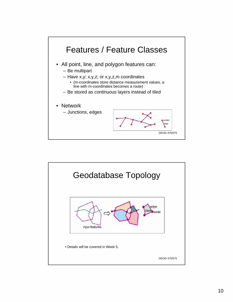
Features / Feature Classes• All point, line, and polygon features can:
– Be multipart– Have x,y; x,y,z; or x,y,z,m coordinates
• (m-coordinates store distance measurement values, a line with m-coordinates becomes a route)
– Be stored as continuous layers instead of tiled
• Network– Junctions, edges
GEOG 475/575
Geodatabase Topology
• Details will be covered in Week 5.
11
GEOG 475/575
ESRI’s GIS Data Structures
High (if topology rules are defined)HighOptionalDBMSPersonal
Geodatabase
Optional
None
Required
Topology
High (if topology rules are defined)HighFile-basedFile
Geodatabase
NoneHighFile-basedShapefile
HighLowFile-basedCoverage
Spatial IntegrityPortabilityTypeData Structure
GEOG 475/575
Spatial Reference• Prior to ArcGIS 9.2, spatial references were low
precision. Each integer coordinate was allotted 31 bits rather than the 53 bits provided by high resolution spatial references created and maintained with 9.2 or above.
• With low precision, you have to specify a domain extent as well as a resolution (precision) value. A large domain extent is only possible with low resolution values.
• Therefore, when working with low-precision spatial references, you must carefully balance the trade-off between domain extent and the resolution or precision values.
12
GEOG 475/575
About x,y Resolution and Domain • A low-precision geodatabase stores coordinates as
positive 4-byte integers that have a maximum value of 2,147,483,647.
• If you need to store meter precision, you have 2.14 billion meters to work with (approximately 53 times the circumference of the earth).
• If you need to store centimeters precision, in which case you would have 2.14 billion centimeters to work with (about one-half the circumference of the earth).
• Resolution values represent the minimum allowed separation between two coordinate values. Resolution values are used to convert decimal values to the integers stored in the geodatabase.
GEOG 475/575