31
portfolio | brett kordenbrock portfolio | brett kordenbrock Master of Landscape Architecture Knowlton School of Architecture The Ohio State University Columbus, OH
| Date post: | 22-Mar-2016 |
| Category: |
Documents |
| Upload: | brett-kordenbrock |
| View: | 216 times |
| Download: | 0 times |

port
folio
|
bre
tt k
orde
nbro
ck
portfolio | brett kordenbrock
Master of Landscape ArchitectureKnowlton School of Architecture
The Ohio State UniversityColumbus, OH
This award winning project explored strategies for infrastructural opportunism. Analyzing the systems of coal-fired power plants led to many potential interventions. The use of excess or wastes in its systems provided an opportunity for interventions. Through thickened hedgerows, power plant waste water reuse, carbon sequestration, and biomass as renewable energy production gives Picway Power Plant a new meaning. By simply understanding existing systems and augmenting them by repositioning their own wastes, Picway Power Plant achieves not only a new aesthetic, but also new operative - habitat patches and corridors are enhanced, thickened impoundment caps provide cover for both animals and a plane for biomass cultivars to be produced, waste water provides a 365-day water fowl environment and subsequently birding on a new scale introduces the human to this machine, and potential CO2 capturing provides
a future energy resource as Ohio looks to diversify its energy portfolio.
COURSE: G1 Design Studio - Infrastructural Opportunism | INSTRUCTOR: Jacob Boswell | DATE: Sp2011
AWARDS: Winning Entry - Association of Collegiate Schools of Architecture “I am Being Resourceful”Student Honor Award - Ohio Chapter of the ASLA (the text above is hyper-linked to the respective award publications)
Augmenting Systems: Strategies for Ecological Intensity at Picway Power PlantDES
IGN
STU
DIO
2
Ohio Coal-�red Power Plants
TOTAL1 = 5 power plants
400+ MW
400- MW
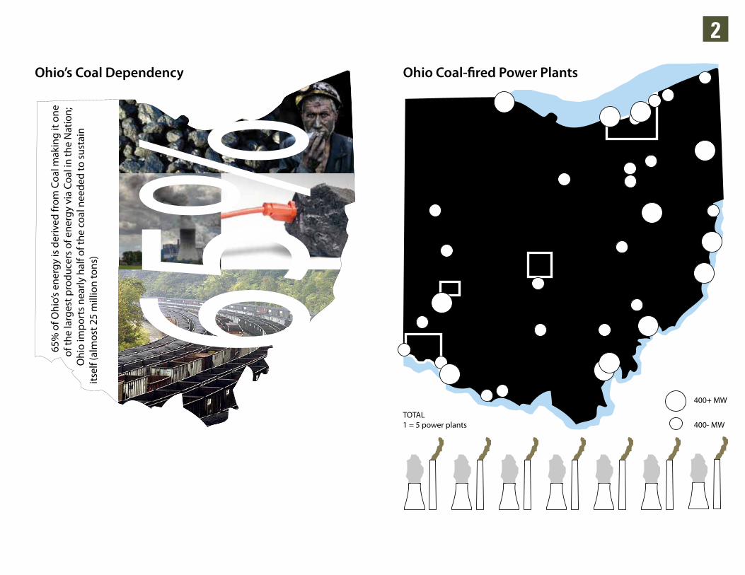
65%
65%
of O
hio’
s en
ergy
is d
eriv
ed fr
om C
oal m
akin
g it
one
of t
he la
rges
t pro
duce
rs o
f ene
rgy
via
Coal
in th
e N
atio
n;
Ohi
o im
port
s ne
arly
hal
f of t
he c
oal n
eede
d to
sus
tain
its
elf (
alm
ost 2
5 m
illio
n to
ns)
Ohio’s Coal Dependency
10m
i Rad
ius
Brett N. KordenbrockSource(s): Ohio Coal; U.S. Department of Energy; SourceWatch
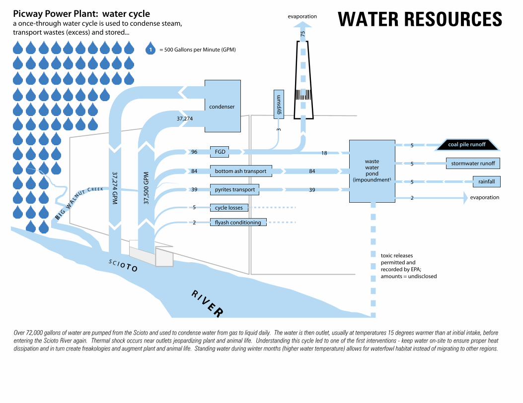
Over 72,000 gallons of water are pumped from the Scioto and used to condense water from gas to liquid daily. The water is then outlet, usually at temperatures 15 degrees warmer than at initial intake, before entering the Scioto River again. Thermal shock occurs near outlets jeopardizing plant and animal life. Understanding this cycle led to one of the first interventions - keep water on-site to ensure proper heat dissipation and in turn create freakologies and augment plant and animal life. Standing water during winter months (higher water temperature) allows for waterfowl habitat instead of migrating to other regions.
WATER RESOURCESPicway Power Plant: water cyclea once-through water cycle is used to condense steam,transport wastes (excess) and stored...
37,5
00 G
PM
37,274 GPM
96
84
39
5
2
FGD
condenser
bottom ash transport
pyrites transport
cycle losses
gyps
um
�yash conditioning
toxic releasespermitted andrecorded by EPA;amounts = undisclosed
3
75
18
evaporation
2 evaporation
wastewaterpond
(impoundment)84
39
stormwater runo�
rainfall
coal pile runo�5
5
5
37,274
S C I O T O
R I V E R
B I G
W A
L N U T C R E E K
Brett N. Kordenbrock
1 = 500 Gallons per Minute (GPM)
Source(s): AEP Ohio - Sustainability Reporting - Chp. EN8
2
3
1
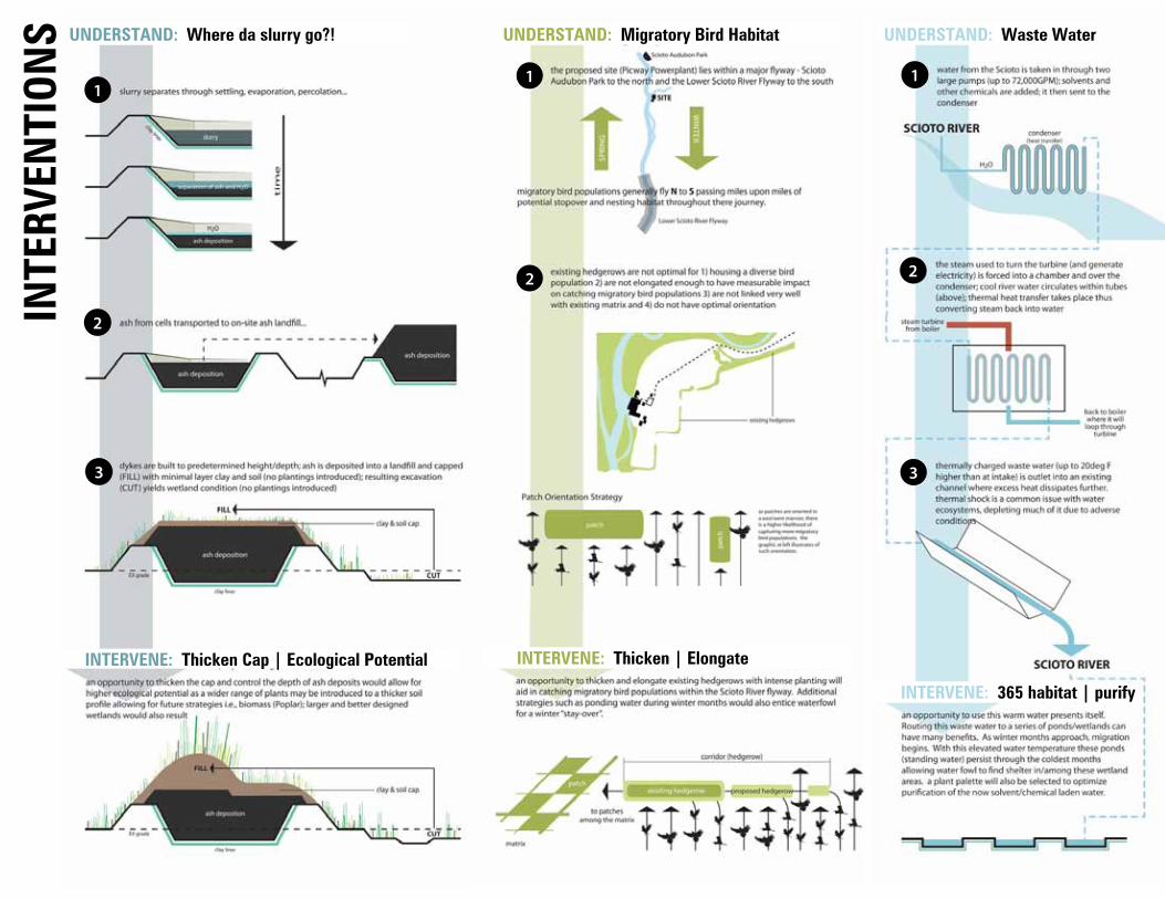
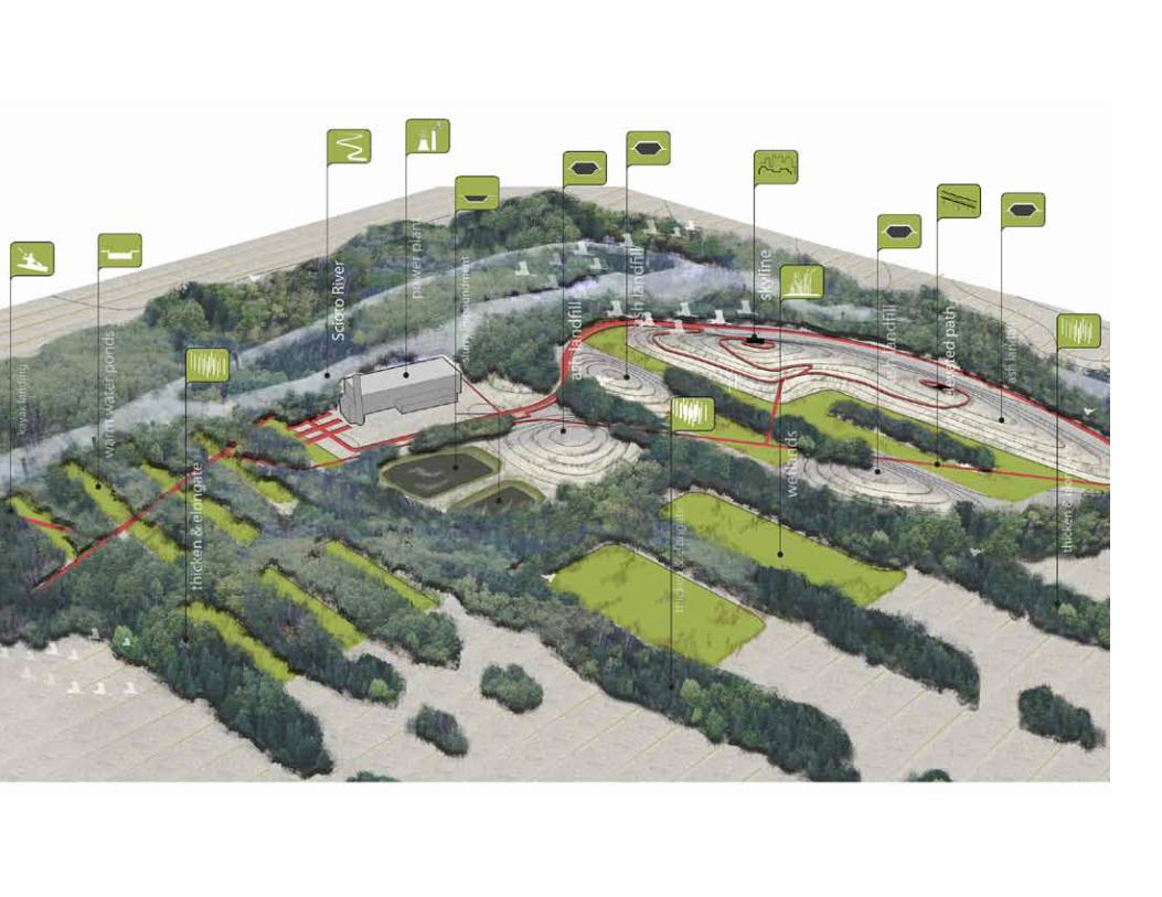
UNDERSTAND: Waste Water
INTERVENE: 365 habitat | purify
2
3
1
UNDERSTAND: Where da slurry go?!
INTERVENE: Thicken Cap | Ecological Potential
1
2
UNDERSTAND: Migratory Bird Habitat
INTERVENE: Thicken | Elongate
INTE
RVEN
TION
S
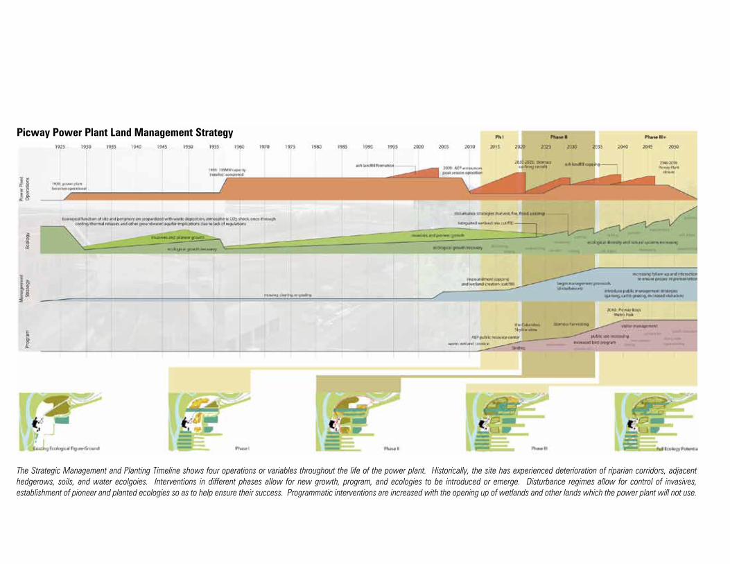
The Strategic Management and Planting Timeline shows four operations or variables throughout the life of the power plant. Historically, the site has experienced deterioration of riparian corridors, adjacent hedgerows, soils, and water ecolgoies. Interventions in different phases allow for new growth, program, and ecologies to be introduced or emerge. Disturbance regimes allow for control of invasives, establishment of pioneer and planted ecologies so as to help ensure their success. Programmatic interventions are increased with the opening up of wetlands and other lands which the power plant will not use.
Picway Power Plant Land Management Strategy
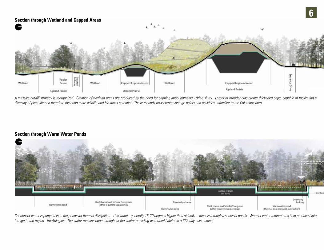
6Section through Wetland and Capped Areas
A massive cut/fill strategy is reorganized. Creation of wetland areas are produced by the need for capping impoundments - dried slurry. Larger or broader cuts create thickened caps, capable of facilitating a diversity of plant life and therefore fostering more wildlife and bio-mass potential. These mounds now create vantage points and activities unfamiliar to the Columbus area.
Section through Warm Water Ponds
Condenser water is pumped in to the ponds for thermal dissipation. This water - generally 15-20 degrees higher than at intake - funnels through a series of ponds. Warmer water tempratures help produce biota foreign to the region - freakologies. The water remains open throughout the winter providing waterfowl habitat in a 365-day environment.
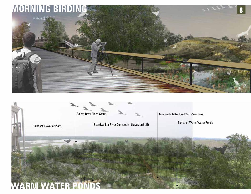
8
WARM WATER PONDS
Boardwalk & Regional Trail Connector
Boardwalk & River Connection (kayak pull-off)
Scioto River Flood Stage
Exhaust Tower of PlantSeries of Warm Water Ponds
MORNING BIRDING
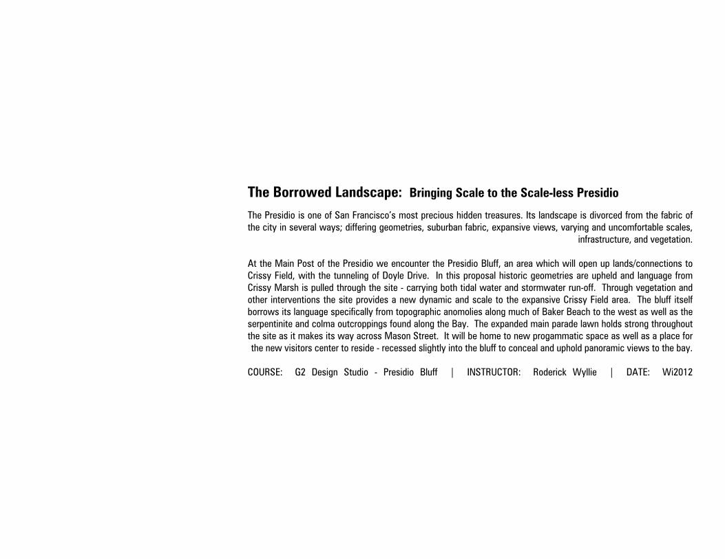
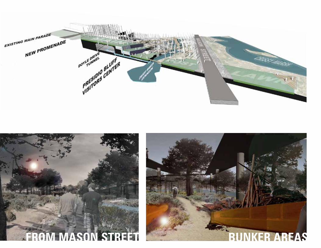
The Presidio is one of San Francisco’s most precious hidden treasures. Its landscape is divorced from the fabric of the city in several ways; differing geometries, suburban fabric, expansive views, varying and uncomfortable scales,
infrastructure, and vegetation.
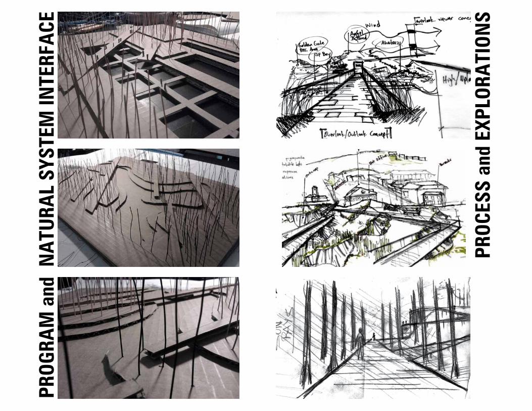
At the Main Post of the Presidio we encounter the Presidio Bluff, an area which will open up lands/connections to Crissy Field, with the tunneling of Doyle Drive. In this proposal historic geometries are upheld and language from Crissy Marsh is pulled through the site - carrying both tidal water and stormwater run-off. Through vegetation and other interventions the site provides a new dynamic and scale to the expansive Crissy Field area. The bluff itself borrows its language specifically from topographic anomolies along much of Baker Beach to the west as well as the serpentinite and colma outcroppings found along the Bay. The expanded main parade lawn holds strong throughout the site as it makes its way across Mason Street. It will be home to new progammatic space as well as a place for the new visitors center to reside - recessed slightly into the bluff to conceal and uphold panoramic views to the bay.
COURSE: G2 Design Studio - Presidio Bluff | INSTRUCTOR: Roderick Wyllie | DATE: Wi2012
The Borrowed Landscape: Bringing Scale to the Scale-less Presidio
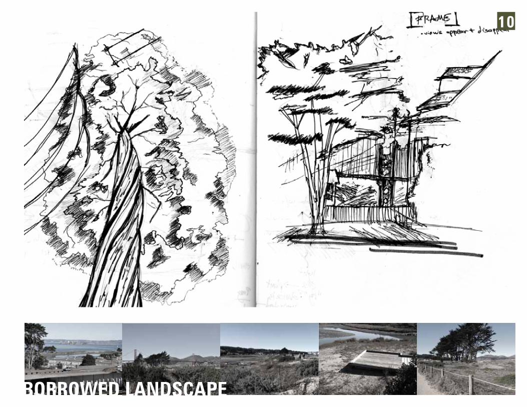
BORROWED LANDSCAPE
10
PROC
ESS
and
EXPL
ORA
TION
S
PROG
RAM
and
NA
TURA
L SY
STEM
INTE
RFA
CE
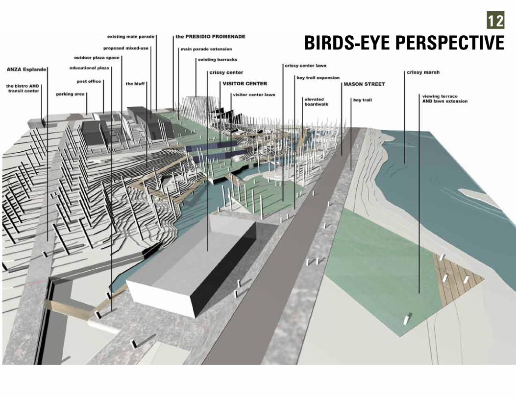
BIRDS-EYE PERSPECTIVE12
BUNKER AREASFROM MASON STREET

SITE
PRO
POSA
LS
LEGENDA transit centerB existing post officeC MAIN PARADED MAIN PARADE EXPANSIONE proposed multi-use buildingsF existing barracksG mixed-use plazaH ANZA EsplandeI VISITORS CENTER (vegetated roof)
J ADA BoardwalkK crissy center lawnL educational plazaM crissy centerN lawn panel and viewing terraceO crissy marsh accessP crissy marshQ PRESIDIO PROMENADE
The term sustainability is pervasive. How do we integrate stormwater management ideas, which are thought of as singular objects, into the urban fabric while activating the public realm? The Short North Cultural District in Columbus, Ohio provides us with many areas, both conventional and unconventional, when we think of the public realm. Can we add green infrastructure to the mix of High Street, a well travelled corridor to improve the quality of life along it? The following studio had a unique development in that 1) groups were formed to analyze area data, resulting in bold infographics, 2) space typologies in the Short North - niches, setbacks, and open lots - were explored through a SWM lens (see typologies and detail), and 3) to intervene in a specific typology and develop it (see Service Station Re-use).
COURSE: G1 Urban Landscape Design Studio | INSTRUCTOR: Jason Kentner | DATE: Au2010
How Green is C-bus?
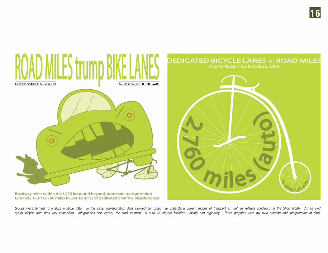
Groups were formed to analyze multiple data. In this case, transportation data allowed our group to understand current modes of transport as well as relative conditions in the Short North. As an avid cyclist bicycle data was vary compelling. Infographics help convey the stark contrast in auto vs. bicycle facilities - locally and regionally. These graphics were my own creation and interpretation of data.
16
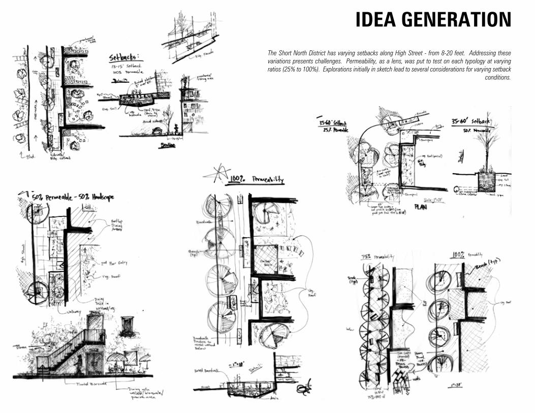
The Short North District has varying setbacks along High Street - from 8-20 feet. Addressing these variations presents challenges. Permeability, as a lens, was put to test on each typology at varying ratios (25% to 100%). Explorations initially in sketch lead to several considerations for varying setback
conditions.
IDEA GENERATION
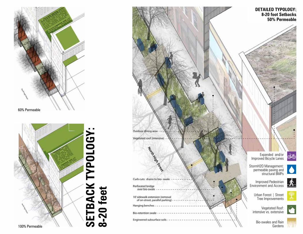
60% Permeable
100% Permeable
DETAILED TYPOLOGY:8-20 foot Setbacks
50% Permeable
Expanded and/orImproved Bicycle Lanes
Urban Forest | Street Tree Improvements
StormH2O Management:permeable paving and
structural BMPs
Vegetated Roof:intensive vs. extensive
Improved Pedestrian Environment and Access
Bio-swales and Rain GardensSE
TBA
CK T
YPOL
OGY:
8-
20 fe
et
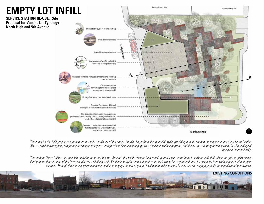
The intent for this infill project was to capture not only the history of the parcel, but also its performative potential, while providing a much needed open space in the Short North District. Also, to provide overlapping programmatic spaces, or layers, through which visitors can engage with the site in various degrees. And finally, to work programmatic zones in with ecological
processes - harmoniously.
The outdoor “Lawn” allows for multiple activities atop and below. Beneath the plinth, visitors (and transit patrons) can store items in lockers, lock their bikes, or grab a quick snack. Furthermore, the rear face of the Lawn couples as a climbing wall. Wetlands provide remediation of water as it works its way through the site collecting from various point and non-point
sources. Through these areas, visitors may not be able to engage directly at ground level due to toxins present in soils, but can engage partially through elevated boardwalks.
AB
SERVICE STATION RE-USE: Site Proposal for Vacant Lot Typology - North High and 5th Avenue
EXISTING CONDITIONS
EMPTY LOT INFILL
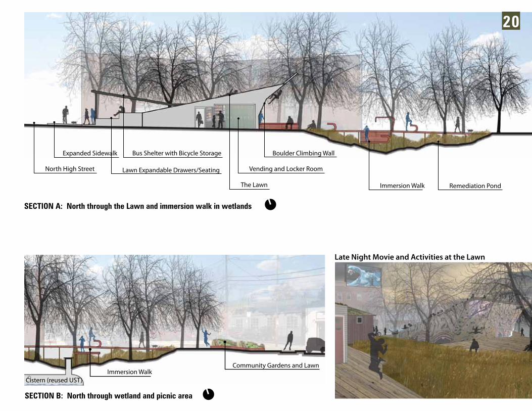
SECTION A: North through the Lawn and immersion walk in wetlands
Late Night Movie and Activities at the Lawn
North High Street Lawn Expandable Drawers/Seating
Expanded Sidewalk
The Lawn
Vending and Locker Room
Boulder Climbing Wall
Immersion Walk Remediation Pond
Bus Shelter with Bicycle Storage
SECTION B: North through wetland and picnic area
Cistern (reused UST)Immersion Walk
Community Gardens and Lawn
20

Ohio State’s Chadwick Arboretum is home to an array of wood plant material. It is being pressured by long-term visions for west campus as OSU begins to create critical mass east of the Olentangy. Chadwick is to be re-envisioned as a place for learning, an array of experiences, habitat enhancement along the Olentangy, and an extension of ideas put forth in the One Framework Plan by Sasaki Associates. Exercises were completed
to understand context - at varying scales - and its implications at the site.
Through this course we are challenging some initial ideas and proposals put forth in the previous quarter. Within design development our proposals were further developed through ideas of character, management, and space as ways to portray and further understand design intent. Various scales and edge conditions
were explored.
COURSE: G2 Earth, Water, Plants Workshop | INSTRUCTOR: Jason Kentner | DATE: Wi2012
CHARACTER | MANAGEMENT | SPACE
WOR
KSHO
P |
GRA
PHIC
S
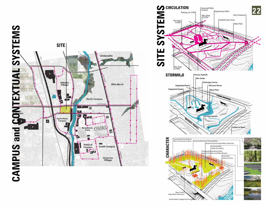
22
SITE
SYS
TEM
S
Bus Stop(COTA)
Sloped Lawn Area
Seasonal Paths(mown)
Parking Lot (100) Exploratory Paths
Main Path
Entry Features
Main Path
Bus Stop(CABS)
Sidewalks
Bus Stop(CABS)
OLENTANGY RIVER
LANE AVENUE
FYFFE ROAD
WOODY HAYES
CIRCULATION
Base Flow
Outlet to River
EX Pipe System
100-year Storm
Drainage Course
Porous Asphalt
Bio-Swale
Vegetated Roof
Vegetated Swale
OLENTANGY RIVER
LANE AVENUE
FYFFE ROAD
WOODY HAYES
STORMH O
OLENTANGY RIVER
LANE AVENUE
FYFFE ROAD
WOODY HAYES
Enclosure/Discovery/Among/WithinPromenade/Framing Views/Allee & Continuity of Space
Grasslands/Meandering Paths
Expansive/Gentle Slope/Water Interaction
Respite/Water Engagement/Enclosure
Enclosed ValleyStage and Seating
Open Prairie
Entry PointExpansive Views
CHA
RACT
ER
SITE
CIRCULATION
STORMH2O
CHA
RACT
ER
CAM
PUS
and
CON
TEXT
UA
L SY
STEM
S
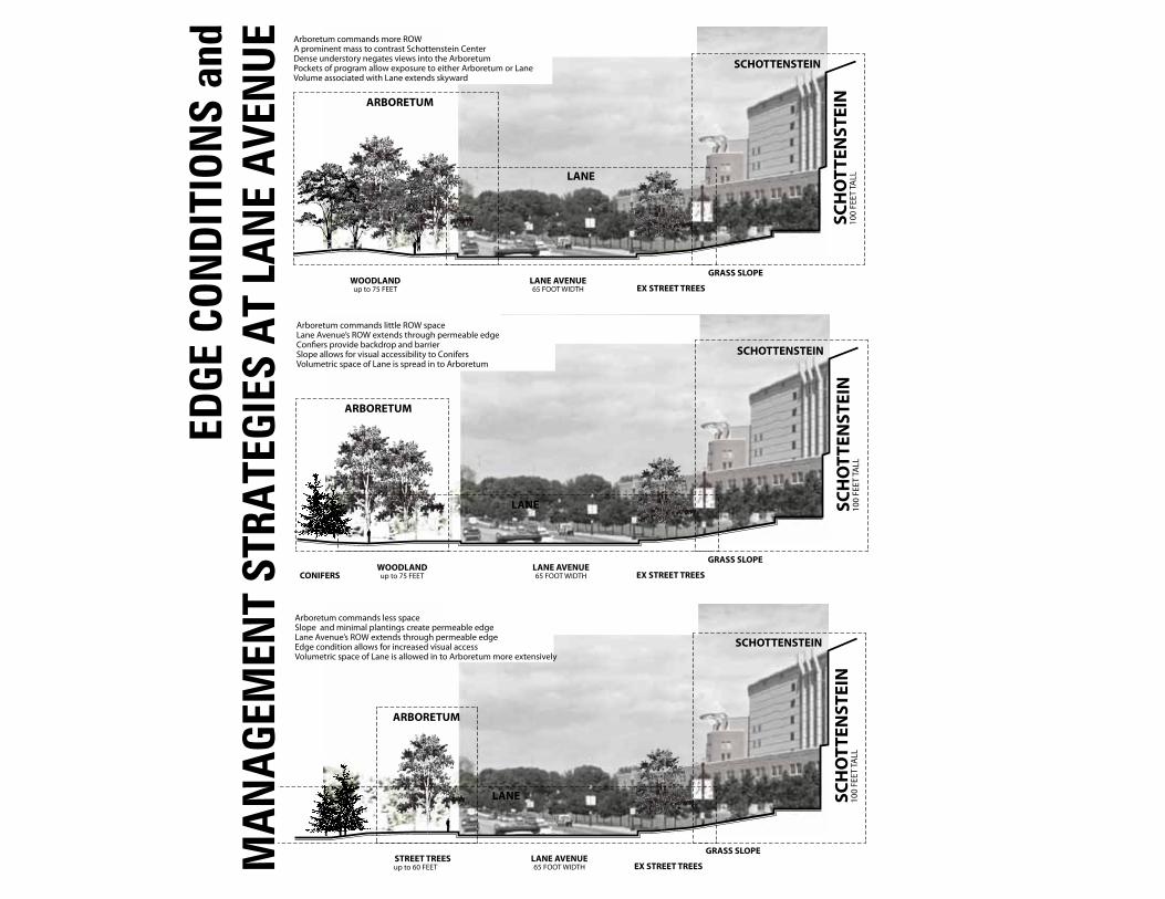
EDGE
CON
DIT
ION
S an
d M
AN
AGE
MEN
T ST
RATE
GIES
AT
LAN
E A
VEN
UE
WOODLAND LANE AVENUE65 FOOT WIDTHup to 75 FEET
GRASS SLOPE
EX STREET TREES
100
FEET
TALL
SCH
OTT
ENST
EINARBORETUM
SCHOTTENSTEIN
LANE
EDGE CONDITIONS @ LANE:
Arboretum commands more ROWA prominent mass to contrast Schottenstein CenterDense understory negates views into the ArboretumPockets of program allow exposure to either Arboretum or LaneVolume associated with Lane extends skyward
WOODLAND LANE AVENUE65 FOOT WIDTHup to 75 FEET
GRASS SLOPE
EX STREET TREES
100
FEET
TALL
SCH
OTT
ENST
EIN
CONIFERS
ARBORETUM
SCHOTTENSTEIN
LANE
EDGE CONDITIONS @ LANE:
Arboretum commands little ROW spaceLane Avenue’s ROW extends through permeable edgeCon�ers provide backdrop and barrierSlope allows for visual accessibility to ConifersVolumetric space of Lane is spread in to Arboretum
STREET TREES LANE AVENUE65 FOOT WIDTHup to 60 FEET
GRASS SLOPE
EX STREET TREES10
0 FE
ET TA
LLSC
HO
TTEN
STEI
N
ARBORETUM
SCHOTTENSTEIN
LANE
EDGE CONDITIONS @ LANE:
Arboretum commands less spaceSlope and minimal plantings create permeable edgeLane Avenue’s ROW extends through permeable edgeEdge condition allows for increased visual accessVolumetric space of Lane is allowed in to Arboretum more extensively
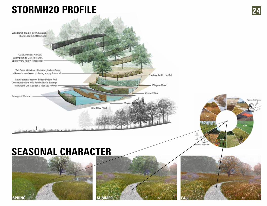
SPRING
STORMH2O PROFILE
SEASONAL CHARACTER
SUMMER FALL
24
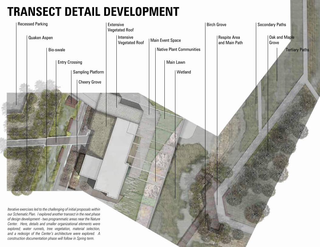
TRANSECT DETAIL DEVELOPMENT
Iterative exercises led to the challenging of initial proposals within our Schematic Plan. I explored another transect in the next phase of design development - two programmatic areas near the Nature Center. Here, details and smaller organizational elements were explored; water runnels, tree vegetation, material selection, and a redesign of the Center’s architecture were explored. A construction documentation phase will follow in Spring term.
Recessed Parking
Quaken Aspen
Bio-swale
Entry Crossing
ExtensiveVegetated Roof
IntensiveVegetated Roof
Sampling Platform
Main Event Space
Native Plant Communities
Main Lawn
Wetland
Birch Grove
Respite Areaand Main Path
Secondary Paths
Tertiary Paths
Oak and MapleGrove
Cheery Grove
Tertiary Paths
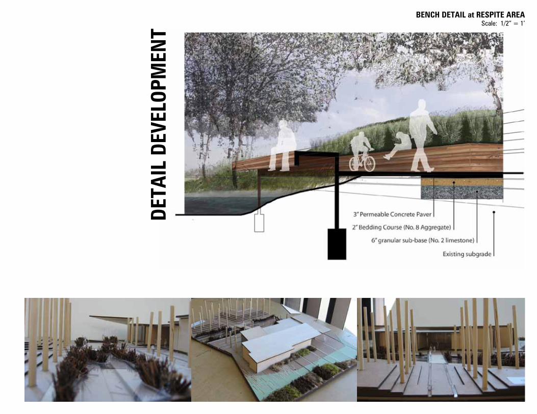
BENCH DETAIL at RESPITE AREAScale: 1/2” = 1’
DET
AIL
DEV
ELOP
MEN
T
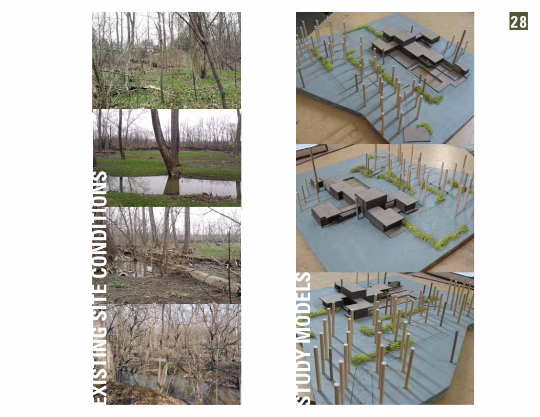
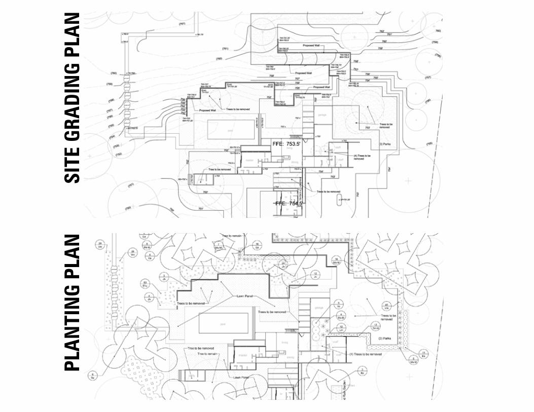
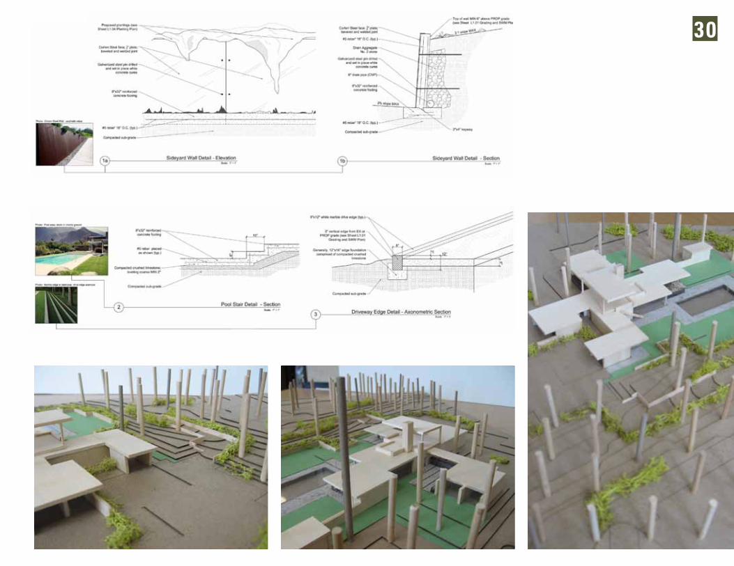
Exploration of this Modernist residence began with modeling, drafting, and understanding Neutra’s design intent with the Kaufman House. This home would then be placed on a site in Columbus, OH. We were to analyze its own systems and conditions through site analysis and inventory. With this information I iterated through the siting of the building
which was to then be developed into a set of preliminary construction documents.
In this proposal, inspiration was drawn from the slight variation in topography near the south edge of the site. A depression of about 12 feet allowed me to site so when approaching the home one would only see a small second floor. As you approach the home your view is deflected away from the home where only slight glimpses of the house itself are seen until it appears before you as you enter the small auto court. As with its original intent, the home was sited to maximize southern exposure for solar thermal uptake. Further details include a robust outdoor lawn, viewing
terraces toward the river, contrasting vegetation, and a Corten retaining wall mimicking Neutra’s design concept.
COURSE: Graphic Representation | INSTRUCTOR: Karla Trott | DATE: Sp2011
Kauffman House: Neutra’s Desert House Finds a Home in Columbus
STU
DY
MOD
ELS
EXIS
TIN
G SI
TE C
OND
ITIO
NS
28
SITE
GRA
DIN
G PL
AN
PLA
NTI
NG
PLA
N
30


![Urban landscape -_introduction[1]](https://static.documents.pub/doc/80x56/54b752c04a795967588b46d7/urban-landscape-introduction1.jpg)


