21
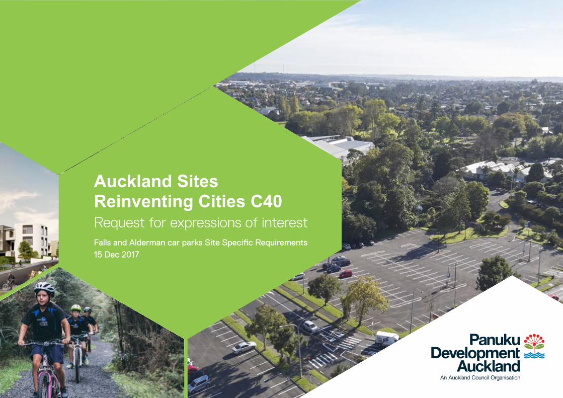
Auckland Sites Reinventing Cities C40 Request for expressions of interest Falls and Alderman car parks Site Specific Requirements 15 Dec 2017
| Date post: | 16-Jun-2018 |
| Category: |
Documents |
| Upload: | truongcong |
| View: | 218 times |
| Download: | 0 times |
Auckland SitesReinventing Cities C40 Request for expressions of interest Falls and Alderman car parks Site Specific Requirements 15 Dec 2017
This Expression of Interest is for the redevelopment of the
two sites into a mixed use residential development. The EOI is
looking for a team to design and construct the development.
This design brief has been prepared by Panuku to help shape
the sites’ development response. It contains guiding design
principles, alongside some mandatory performance standards
and regulatory considerations.
The two sites are offered separately, but are complementary
and share many common features. Bidding teams may present
design proposals that cover either or both sites.
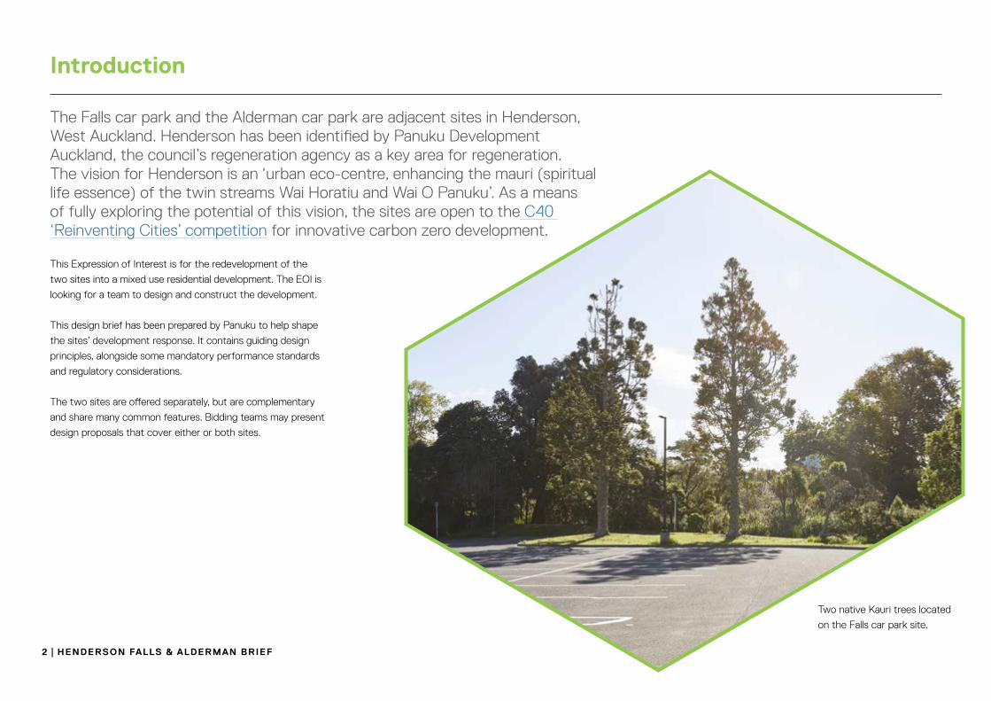
The Falls car park and the Alderman car park are adjacent sites in Henderson, West Auckland. Henderson has been identified by Panuku Development Auckland, the council’s regeneration agency as a key area for regeneration. The vision for Henderson is an ‘urban eco-centre, enhancing the mauri (spiritual life essence) of the twin streams Wai Horatiu and Wai O Panuku’. As a means of fully exploring the potential of this vision, the sites are open to the C40 ‘Reinventing Cities’ competition for innovative carbon zero development.
Two native Kauri trees located
on the Falls car park site.
2 | Henderson falls & alderman BrIef
Introduction

aUCKlandTāmaki
makaurau
neW Zealandaotearoa
aUCKland
WesT aUCKland
Henderson
C40 sites
WesT aUCKland Henderson
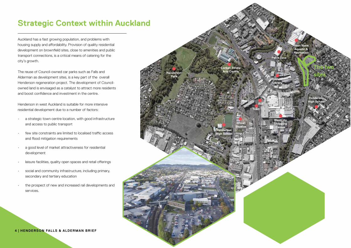
Auckland has a fast growing population, and problems with
housing supply and affordability. Provision of quality residential
development on brownfield sites, close to amenities and public
transport connections, is a critical means of catering for the
city’s growth.
The reuse of Council-owned car parks such as Falls and
Alderman as development sites, is a key part of the overall
Henderson regeneration project. The development of Council-
owned land is envisaged as a catalyst to attract more residents
and boost confidence and investment in the centre.
Henderson in west Auckland is suitable for more intensive
residential development due to a number of factors:
• a strategic town centre location, with good infrastructure
and access to public transport
• few site constraints are limited to localised traffic access
and flood mitigation requirements
• a good level of market attractiveness for residential
development
• leisure facilities, quality open spaces and retail offerings
• social and community infrastructure, including primary,
secondary and tertiary education
• the prospect of new and increased rail developments and
services.
4 | Henderson falls & alderman BrIef
strategic Context within auckland
Henderson Park
Corban Estate Arts Centre
Henderson High School
Henderson High School
Whoa! Studios
Train
Bus
Unitec/Library
Pak’n Save
West WaveAquatic &
Recreation
Tui Glen Reserve
WestCityShopping
Centre
The two sites

TradingPlace
Stevies Lane
Takapu Street
Rata
nui
Str e
et
Great North Road
Alderman
Drive
Alderman
Drive
Sel Peacock Drive
Edmonton Road
Edmonto n
Road
WaitakereC
entral
CranwellPark
FallsPark
NeweysCorner
Cranwell Esplanade
WaitakereCentral Library
PioneerPark
´
Scale @ A41:2,500
Date Printed:15/12/2017
0 10 20 30
Meters
=
DISCLAIMER:This map/plan is illustrative only and all information should beindependently verified on site before taking any action.Copyright Auckland Council. Land Parcel Boundary informationfrom LINZ (Crown Copyright Reserved). Whilst due care hasbeen taken, Auckland Council gives no warranty as to theaccuracy and plan completeness of any information on thismap/plan and accepts no liability for any error, omission or useof the information. Height datum: Auckland 1946.
Auckland Council Map
The sites are owned by Auckland Council and have been
identified for sale for residential / mixed use development.
Panuku Development Auckland will manage the disposal of
the assets on behalf of Council. Both sites are designated as
car parks and operated by Auckland Transport. Panuku will
secure the sites’ release for sale via a parking management
plan to be agreed by Auckland Transport.
Henderson falls & alderman BrIef | 5
Site ownership & release - the two sites
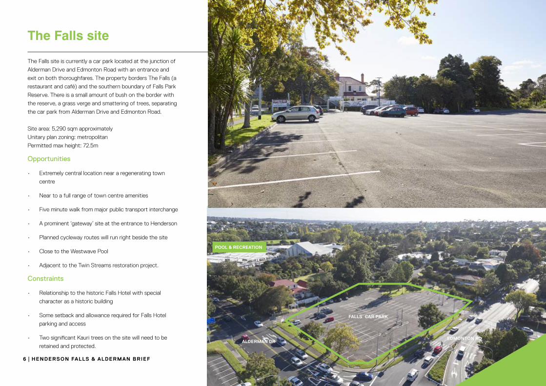
The Falls site is currently a car park located at the junction of
Alderman Drive and Edmonton Road with an entrance and
exit on both thoroughfares. The property borders The Falls (a
restaurant and café) and the southern boundary of Falls Park
Reserve. There is a small amount of bush on the border with
the reserve, a grass verge and smattering of trees, separating
the car park from Alderman Drive and Edmonton Road.
Site area: 5,290 sqm approximately
Unitary plan zoning: metropolitan
Permitted max height: 72.5m
Opportunities
• Extremely central location near a regenerating town
centre
• Near to a full range of town centre amenities
• Five minute walk from major public transport interchange
• A prominent ‘gateway’ site at the entrance to Henderson
• Planned cycleway routes will run right beside the site
• Close to the Westwave Pool
• Adjacent to the Twin Streams restoration project.
Constraints
• Relationship to the historic Falls Hotel with special
character as a historic building
• Some setback and allowance required for Falls Hotel
parking and access
• Two significant Kauri trees on the site will need to be
retained and protected.
Pool & reCreaTIon
falls Car ParK
alderman dredmonTon rd
6 | Henderson falls & alderman BrIef
The Falls site

The site is currently a car park located between Edmonton
Road and the Oratia Stream, with access from Edmonton
Road via the southern and northern ends of the car park.
There is a small amount of bush between the car park and
the watercourse. and a grass verge and smattering of trees
separating the car park from the road edge. On the western
boundary, a pedestrian bridge across the Wai Horotiu / Oratia
Stream connects the site with Trading Place.
Site area: 7,223sqm approximately
Unitary plan zoning: metropolitan / open space
Permitted max height: 72.5m
Opportunities
• Extremely central location near a regenerating town
centre
• Near to a full range of town centre amenities
• Five minute walk from major public transport interchange
• A prominent ‘gateway’ site at the entrance to Henderson
• Planned cycleway routes will run right beside the site
• Close to the Westwave Pool
• Adjacent to the Twin Streams restoration project.
Constraints
• Long irregular shape of site
• Adjacent to the Wai Horotiu / Oratia Stream
• Uneven topography – the land slopes to the west
towards the stream
alderman Car ParK
edmonTon road
alderman dr
BrIdge To lIBraryoraTIa sTream
Henderson falls & alderman BrIef | 7
The alderman site

OPANUKURESERVE
HENDERSON PARK
FALLS PARK
END OF ORATIA PATH
OPANUKU PATH
HENDERSON CREEK PATH
Map KeyPROPOSEDNEW WALKING /CYCLING LINKS
STREAMS
IMPROVE CROSSING
MAIN TWIN STREAMS PATHS
SECONDARY TWIN STREAMS PATHS
KEY DESTINATIONS
SCHOOLS
PANUKU DEVELOPMENT SITES
PROPOSED NEW WALKING & CYCLING LINKS
to better connect development sites and existing paths through Henderson urban eco-centre
SCHOOL
STATION
LIBRARY
POOLS
CORBANS
SCHOOL
TUI GLEN
PROJECT 2 DEVELOPMENT
SITE
The Unlock Henderson High Level Project Plan 2017 forms the guiding document for the regeneration and growth of Henderson as an urban eco centre. Capitalising on 20 years of strategic thinking, the plan embodies the full potential of Henderson. It establishes that Henderson is an exceptional sustainability-led opportunity requiring an exceptional response.To read the plan visit: panuku.co.nz/henderson
VisionThe vision proposed for Henderson is for it to grow
into an urban eco-centre, enhancing the mauri (life
essence) of the Twin Streams Wai o Panuku and Wai
Horotiu that converge in its centre.
This vision will guide planning and development in
Henderson – with the outcome towards ‘liveable
growth’ by creating a safe, attractive and vibrant
mixed-use environment with a uniquely
west Auckland identity.
It is hoped the strong ‘eco’ focus will act as a catalyst
for high-quality living and development that resonates
with and attracts families, businesses, investors and
visitors to this growing metropolitan area.
development principles
• an emphasis on attracting and retaining families
when planning developments
• reinforce the west Auckland and eco-centre
identity to enhance perceptions
• integrate green building features in each
development, building a point of difference
• include partnership with the community, mana
whenua, matawaaka and council organisations in
development planning
• ensure a place-led approach, embed Te Aranga
design principles and reflect the cultural
narrative in developments.
8 | Henderson falls & alderman BrIef
Vision, Principles & goals
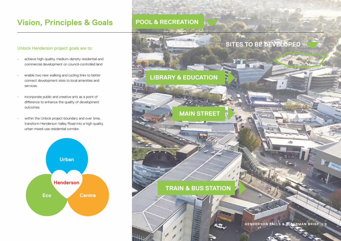
Unlock Henderson project goals are to:
• achieve high-quality, medium-density residential and
commercial development on council-controlled land
• enable two new walking and cycling links to better
connect development sites to local amenities and
services
• incorporate public and creative arts as a point of
difference to enhance the quality of development
outcomes
• within the Unlock project boundary and over time,
transform Henderson Valley Road into a high quality,
urban mixed-use residential corridor.
Figure 1 – Diagrams from the Henderson Implementation Plan and the Henderson-Massey Local Board’s Value Proposition where Henderson’s heart is found in developing quality, sustainable urban living environments.
Eco city
Diverse communities
Urban
CentreEco
Wine heritage
Creative /arts hub
HendersonBut where is the heart
?
17PANUKU DEVELOPMENT AUCKLAND
lIBrary & edUCaTIon
sITes To Be deVeloPed
maIn sTreeT
Pool & reCreaTIon
TraIn & BUs sTaTIon
Henderson falls & alderman BrIef | 9
Vision, Principles & goals
10 | Henderson falls & alderman BrIef
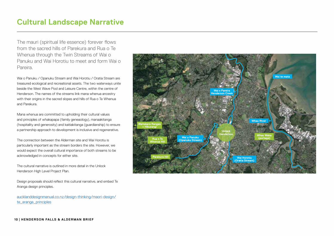
The mauri (spiritual life essence) forever flows from the sacred hills of Parekura and Rua o Te Whenua through the Twin Streams of Wai o Panuku and Wai Horotiu to meet and form Wai o Pareira.
Wai o Panuku / Opanuku Stream and Wai Horotiu / Oratia Stream are
treasured ecological and recreational assets. The two waterways unite
beside the West Wave Pool and Leisure Centre, within the centre of
Henderson. The names of the streams link mana whenua ancestry
with their origins in the sacred slopes and hills of Rua o Te Whenua
and Parekura.
Mana whenua are committed to upholding their cultural values
and principles of whakapapa (family geneaology), manaakitanga
(hospitality and generosity) and kaitiakitanga (guardianship) to ensure
a partnership approach to development is inclusive and regenerative.
The connection between the Alderman site and Wai Horotiu is
particularly important as the stream borders the site. However, we
would expect the overall cultural importance of both streams to be
acknowledged in concepts for either site.
The cultural narrative is outlined in more detail in the Unlock
Henderson High Level Project Plan.
Design proposals should reflect this cultural narrative, and embed Te
Aranga design principles.
aucklanddesignmanual.co.nz/design-thinking/maori-design/te_aranga_principles
Cultural landscape narrative
3.1 CULTURAL NARRATIVE
The mauri (spiritual life essence) forever � ows from the sacred hills of Parekura and Rua o Te Whenua through the Twin Streams of Wai o Panuku and Wai Horotiu to meet and form Wai o Pareira.
Wai o Panuku/Opanuku Stream and Wai Horotiu/Oratia Stream are treasured ecological and recreational assets. These two waterways unite beside the West Wave Pool and Leisure Centre, within the centre of Henderson. The names of the streams link mana whenua ancestry with their origins in the sacred slopes and hills of Rua o Te Whenua and Parekura.
The Twin Streams and their catchments de ne central Henderson. They ow from their physical, ancestral and spiritual sources in Hikurangi/the Waitākere Ranges. Converging at Cranwell Park, they form Te Wai o Pareira/Henderson Creek or the river of Pareira, and ow to the upper Waitematā Harbour. Mana whenua identify strongly with the streams and the catchment they serve. Pareira was the niece of ancestor and voyager Toi Te Huatahi.
Wai o Panuku is linked with Parekura, the wife of Rangatira Panuku. Wai Horotiu was named after horotiu (landslips) characteristic of the catchment and is a name associated with pā and kāinga in Oratia.
Immediately to the north-east, a third tributary, the Wai Whauwhaupaku/Swanson Stream, also has signi cant mana whenua cultural associations. Immediately to the east of Henderson lies the 3km-long Whau waka (canoe) portage from the Whau River in the upper Waitematā Harbour to Green Bay on the northern Manukau Harbour. The importance of the portage is supported by the existence of headland pā which controlled the harbour access point.
The former Waitākere City Council acknowledged the importance of the mana whenua association and narrative for Henderson, expressions of which are key features of the Waitākere Central Civic Centre. The retention and recognition of these structures and design is of cultural importance. These features include an entry pou and internal pou which extends from the building’s foundations to its roof. The Council Chamber is symbolic of a gourd and features the Matariki constellation (Pleiades) on its main wall and displays both English and Te Reo Māori versions of the Te Tiriti o Waitangi/the Treaty of Waitangi. These cultural elements represent mana whenua and signify their close association with Henderson and its wider environment.
Mana whenua are committed to upholding their cultural values and principles of whakapapa (family geneaology), manaakitanga (hospitality and generosity) and kaitiakitanga (guardianship) to ensure a partnership approach to development is inclusive and regenerative. Collaborative partnerships and engagements across the physical boundaries of the project footprint will consider aspects including rangatahi (youth) and the elderly, healthcare, housing, economic development and environmentally-friendly outcomes underpinned by a strong sustainability ethos.
In all matters mātauranga (knowledge) and tikanga (protocols), Māori will be provided for where appropriate. Through the recognition of mana whenua values it is important that the mauri of natural, physical and spiritual resources (including the wider catchment) and the Waitematā Harbour as a receiving environment are respected and enhanced.
Parekura became the hill of that name, which stands at the head of the Henderson Valley. From Parekura forever ows the stream Wai o Panuku which embodies the spiritual essence of Panuku1
1: Statement of Association: Te Wai o Pareira/Henderson Creek. Te Kawerau ā Maki and the Trustees of Te Kawerau Iwi Settlement Trust and the Crown. Deed of Settlement Schedule: Documents (22 February 2014). Other key narrative information presented is also drawn from this source.
Figure 2: Henderson Valley in the cultural landscape. Courtesy Google Maps.
Unlock Henderson
Wai o PareiraHenderson Creek
Wai o Panuku (Opanuku Stream)
Wai Horotiu (Oratia Stream)
Whau River
Whau Waka(portage)Rua o Te
Whenua Hill
Parekura Hill
Waitakere Ranges + Hikurangi
Wai te mata
21PANUKU DEVELOPMENT AUCKLAND20 PANUKU DEVELOPMENT AUCKLAND
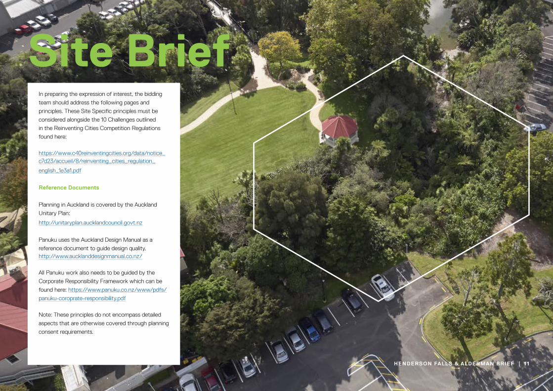
In preparing the expression of interest, the bidding
team should address the following pages and
principles. These Site Specific principles must be
considered alongside the 10 Challenges outlined
in the Reinventing Cities Competition Regulations
found here:
https://www.c40reinventingcities.org/data/notice_c7d23/accueil/8/reinventing_cities_regulation_
english_1e3a1.pdf
reference documents
Planning in Auckland is covered by the Auckland
Unitary Plan:
http://unitaryplan.aucklandcouncil.govt.nz
Panuku uses the Auckland Design Manual as a
reference document to guide design quality. http://www.aucklanddesignmanual.co.nz/
All Panuku work also needs to be guided by the
Corporate Responsibility Framework which can be
found here: https://www.panuku.co.nz/www/pdfs/
panuku-coroprate-responsibility.pdf
Note: These principles do not encompass detailed
aspects that are otherwise covered through planning
consent requirements.
Henderson falls & alderman BrIef | 11
site Brief
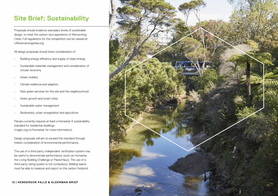
Proposals should evidence exemplary levels of sustainable
design, to meet the carbon zero aspirations of Reinventing
Cities. Full regulations for the competition can be viewed at
c40reinventingcities.org
All design proposals should show consideration of:
• Building energy efficiency and supply of clean energy
• Sustainable materials management and consideration of
circular economy
• Green mobility
• Climate resilience and adaption
• New green services for the site and the neighbourhood
• Green growth and smart cities
• Sustainable water management
• Biodiversity, urban revegetation and agriculture
Panuku currently requires at least a Homestar 6 sustainability
standard for residential dwellings
(nzgbc.org.nz/homestar for more information).
Design proposals will aim to exceed this standard through
holistic consideration of environmental performance.
The use of a third-party, independent verification system may
be useful to demonstrate performance, (such as Homestar,
the Living Building Challenge or PassivHaus). The use of a
third-party rating system is not compulsory. Bidding teams
must be able to measure and report on the carbon footprint
12 | Henderson falls & alderman BrIef
site Brief: sustainability

Henderson falls & alderman BrIef | 13
site Brief: environmental Considerations
A part of the two sites area is affected by flooding
during a 100 year storm event. Most of this flooding
is less than 500mm.
The existence of any soil contamination has not yet
been determined.
Due diligence reporting including an investigation
of contamination, geotechnical, infrastructure and
planning matters will be undertaken by Panuku
during the EOI phase. Reports will be made available
to potential bidders
Indicative Site Boundaries
Contours
Underground Services (https://geomapspublic.aucklandcouncil.govt.nz)
Overland Flow Path
14 | Henderson falls & alderman BrIef
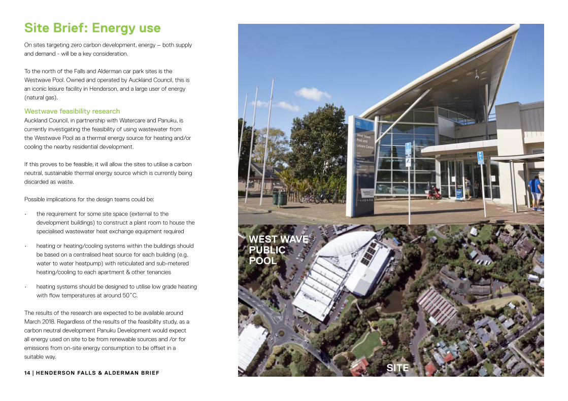
site Brief: energy useOn sites targeting zero carbon development, energy – both supply
and demand - will be a key consideration.
To the north of the Falls and Alderman car park sites is the
Westwave Pool. Owned and operated by Auckland Council, this is
an iconic leisure facility in Henderson, and a large user of energy
(natural gas).
Westwave feasibility researchAuckland Council, in partnership with Watercare and Panuku, is
currently investigating the feasibility of using wastewater from
the Westwave Pool as a thermal energy source for heating and/or
cooling the nearby residential development.
If this proves to be feasible, it will allow the sites to utilise a carbon
neutral, sustainable thermal energy source which is currently being
discarded as waste.
Possible implications for the design teams could be:
• the requirement for some site space (external to the
development buildings) to construct a plant room to house the
specialised wastewater heat exchange equipment required
• heating or heating/cooling systems within the buildings should
be based on a centralised heat source for each building (e.g.
water to water heatpump) with reticulated and sub-metered
heating/cooling to each apartment & other tenancies
• heating systems should be designed to utilise low grade heating
with flow temperatures at around 50˚C.
The results of the research are expected to be available around
March 2018. Regardless of the results of the feasibility study, as a
carbon neutral development Panuku Development would expect
all energy used on site to be from renewable sources and /or for
emissions from on-site energy consumption to be offset in a
suitable way.
WesT WaVe PUBlIC Pool
sITe
It is anticipated that the most feasible built form in this
location is for two-three level terraced housing and/or three
level walk-up apartment typologies. However, the planning
provisions allow for a higher building envelope.
Typologies could range from one and two bedroom dwellings
(50-80sqm) to three -four bedroom family oriented dwellings.
Panuku would strongly encourage developers to achieve
higher than three levels however this may not be viable due
to market receptiveness.
The existing floodplain will likely require the need for elevated
building platforms and the overland flowpath may require
the need for a ‘no build’ easement. This will require further
assessment from a suitably qualified flooding engineer.
The sites front high traffic volume, mixed-use arterial roads
and there will be a need to address site access points with
a view to having limited (one or two) access points. No
garaging or “per unit” driveway crossings will be acceptable
along Alderman Drive or Edmonton Road frontages.
Garaging (if any) will need to be masked or hidden from
the street frontage. The current roundabout intersection
itself may need to be addressed as part of the development
planning process. There have been previous plans for an
intersection upgrade to traffic lights however there are
currently no plans for this project in the pipeline by Auckland
Transport. These plans are likely to resurface during the
planning approvals process.
Any building height and mass must carefully consider shading
impacts, particularly on any private or proposed public open
space provided as part of the development.
These are important “gateway” sites and the architecture
will need to be of a high quality. Development is highly
visible from all sides and will need to be designed ‘in
the round’ and show how all the elevations have been
considered together.
Elevation variety is encouraged in building height/roof
scape along Edmonton Road and Alderman Drive.
The built form design will need to address the issue of
Crime Prevention Through Environmental Design (CPTED).
For the Alderman car park, Panuku and Auckland Transport
want to allow for a walking and cycling shared path along
the Oratia stream on this site. As part of the planning
requirements an esplanade setback of up 20m (negotiable)
will need to be provided. The shared path would be
located within this vested esplanade area as part of the
development planning and approvals process.
In addition a connection from the library across the stream,
over the current pedestrian bridge to the intersection will
need to be provided for (refer to diagram).
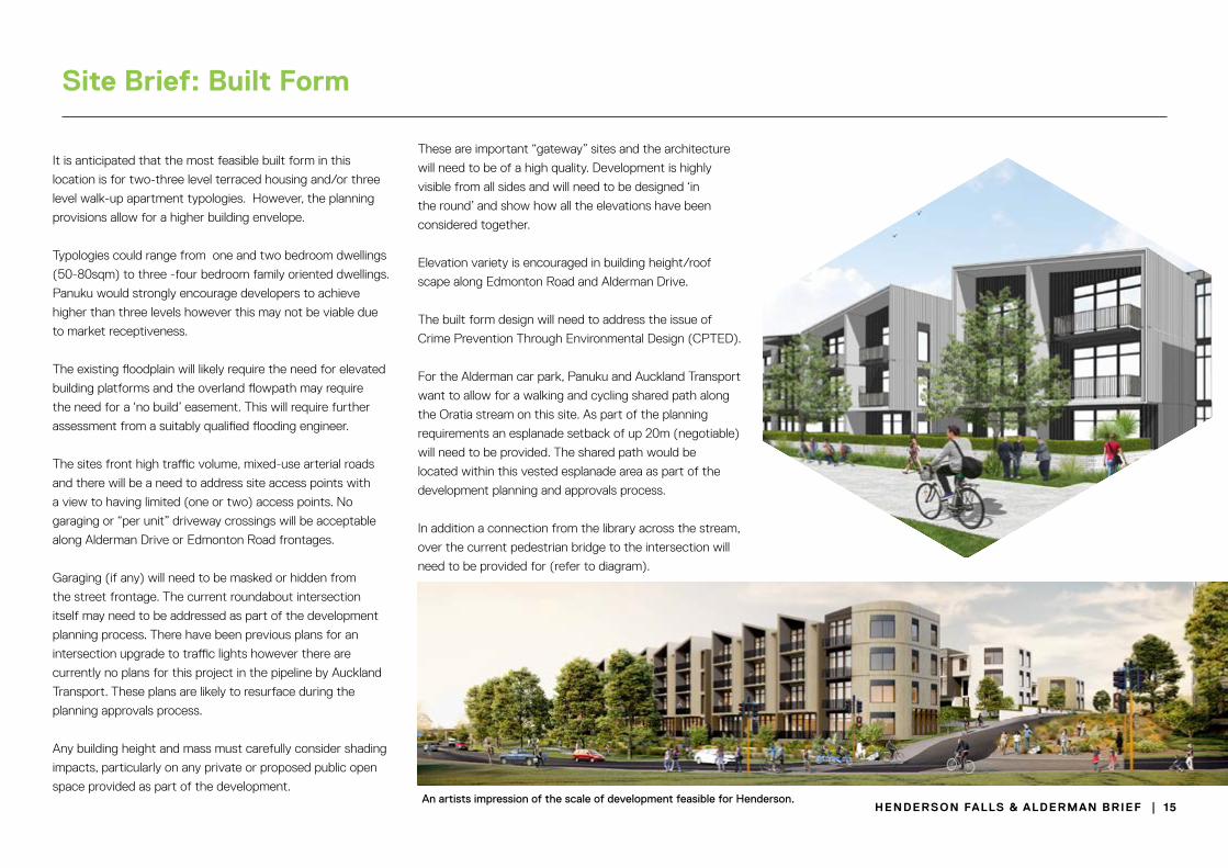
An artists impression of the scale of development feasible for Henderson.Henderson falls & alderman BrIef | 15
site Brief: Built form

SITE BOUNDARY
SIT
E B
OU
ND
AR
Y
FA
LL
S C
AR
PA
RK
EDMONTON RD
TRADING PLACE
GR
EA
T N
OR
TH
RD
ALDERMAN D
R
ORATIA STREAM
ED
MO
NT
ON
RD
PARKINGCONCEALED
CONSIDER INTERFACE WITH
NEWEY’S RESERVE
CONSIDEROUTLOOK
CONSIDER INTERFACE WITH HISTORIC FALLS
HOTEL
MUST INCOROPORATE 2 PROTECTED KAURI
TREES
CONSIDER INTERFACE WITH
LIBRARY
PO
TE
NT
IAL V
EH
ICLE
AC
CE
SS
POTENTIAL VEHICLE ACCESS
WALKING AND CYCLING CONNECTIONW
AL
KIN
G &
CY
CL
ING
CO
NN
EC
TIO
N
(CO
UN
CIL
CO
NT
RO
LL
ED
SIT
E)
VIS
UA
L & S
PATIAL C
ON
NEC
TION
PO
TE
NT
IAL
RE
SID
EN
TIA
L
DE
VE
LOP
ME
NT
POTENTIAL
RESIDENTIAL
DEVELOPMENT
POTENTIAL
RESIDENTIAL
DEVELOPMENT
POTENTIAL
RESIDENTIAL
DEVELOPMENT
CONSIDER POSSIBLE
INTERSECTION
REDESIGN
CONSIDER ENTRANCE
VIEW AS THE NORTH
EASTERN “GATEWAY TO
HENDERSON”
POTENTIAL
RESIDENTIAL
DEVELOPMENT
PO
TE
NT
IAL
RE
SID
EN
TIA
L
DE
VE
LO
PM
EN
T
L IBRARY
HO
TE
L
N
16 | Henderson falls & alderman BrIef
site Brief: Built form diagram guide

Henderson is well served by public transport. The Falls
and Alderman sites are five minutes walk (600m) from the
Henderson Train Station. The new City Rail Link (under
construction) is expected to reduce train travel time to the
Auckland city centre, to only 35 minutes.
There are three existing public bus routes that go past the sites.
Both sites are close to the Twin Streams Cycleway. Auckland
Transport and Panuku have proposed an extension of the
Cycleway that would run alongside the Alderman site.
Both sites are easy walking distance to amenities including a
shopping mall, primary school, library and Westwave Pool.
Development should encourage public transport use, walking
and cycling, and minimize provision of private car parking.
Henderson falls & alderman BrIef | 17
site Brief: Transport

The site is zoned “Metropolitan Centre’ in the Auckland Unitary
Plan which can be found here:
http://unitaryplan.aucklandcouncil.govt.nz
The following is a summary of some of the controls.
These controls are summary guidance only. submitters
will be required to carry out their own assessment.
Height in relation to boundary: 45degrees+16.5m against Informal Recreation zone
Building setback at upper floors: 60degrees+8m against THAB zone
Yards: Dwellings in the Metropolitan Centre zone must not locate on
the ground floor of a building adjoining public open spaces and
streets.
MINIMUM DWELLING SIZE
MIN =50M² MIN = 35M²
1 BEDROOM STUDIO
GENERAL HEIGHT CONTROL
72.5M
SERVICE/TERRACE
BUILDING
Ground Level
HEIGHT IN RELATION TO BOUNDARY
AD
JAC
EN
T S
ITE
BO
UN
DA
RY
72.5M
HE
IGH
T
DEGREE °
BUILDING SETBACK
Y
XA
B
FR
ON
T B
OU
ND
AR
Y
STREETSITE
55M M
AX
OUTLOOK SPACE
20M
15M
10M
6M
50m
24m
16m
10m
0m Ground Level
Outlook court secured over eigther the site, legal
road, public open space or adjoining sites
Minimum dwelling size: Dwellings must have a net internal floor area as follows:
a) 35m² for studio dwellings.
b) 50m² for one or more bedroom dwellings.
Maximum impervious area in the riparian yard: The maximum impervious area within a riparian yard must not
exceed 10 per cent of the riparian yard area.
Landscaping: A landscape buffer of 2m in depth must be provided along the
street frontage between the street and car parking, loading, or
service areas which are visible from the street frontage. This rule
excludes access points.
Outlook Space: An outlook space must be provided from each face of the building
containing windows to living areas or bedrooms of any dwelling.
The minimum dimensions for outlook space are:
a) For principal living areas, the dimensions of the outlook space,
measured perpendicular to the exterior face of the building for the
relative height of the floor above the average ground level along
each building face; or
b) For bedrooms, the outlook space must be a minimum of 6m,
measured perpendicular to the exterior face of the building.
Building Height: 72.5m
18 | Henderson falls & alderman BrIef
site Brief: relevant planning rules

These guidelines have been developed by C40 as part of the
Reinventing Cities competition. Bidding teams should refer to
the full competition regulations at
www.c40reinventingcities.org
All information regarding the expression of interest including
submission guidelines is contained on the website at:
https://www.c40reinventingcities.org/en/guidelines/
The regulation document is available here:
https://www.c40reinventingcities.org/data/notice_c7d23/ac-
cueil/8/reinventing_cities_regulation_english_1e3a1.pdf
The site specific requirements (SSR) is this expression of
interest document.
Submitters will be required to submit via the following pages
https://www.c40reinventingcities.org/en/sites/filter-auck-
land/
Henderson falls & alderman BrIef | 19
eXPressIon of InTeresT gUIdelInes
Auckland Council owns a diverse portfolio of land from open
space to commercial property. Panuku Development Auckland
is the Council Controlled Organisation (CCO) that manages
and delivers value from this land on behalf of the Council.
Panuku identifies important pieces of land that are
underutilised and if developed can address key challenges
that Auckland is facing, such as providing more homes and
creating positive change to communities through better use
of land.
As a CCO, Panuku is expected in its facilitation role to
push market boundaries around the type of homes and
developments that are delivered to best meet the needs of
the wider community. Panuku helps rejuvenate parts of our
city – from small projects that refresh a site or building, to
major transformations of town centres or neighbourhoods.
Panuku manages in the order of $2 billion of Council’s
property portfolio, which they continuously review to find
smart ways to generate income for the region, grow the
portfolio or release land or properties that can be better used
by others. Together with partners Panuku unlocks the full
potential of this land to create spaces for Aucklanders to love.
20 | Henderson falls & alderman BrIef
about Panuku development auckland

Contacts
Leave a message for us atc40reinventingcities.org/en/sites/the-falls-carpark-1306.htmlc40reinventingcities.org/en/sites/the-alderman-carpark-1305.html
C40 Reinventing Cities
Questions/ Enquiries


