50
Version 2.1.1 – June 2016 Australian Hydrological Geospatial Fabric (Geofabric) User Guide Connect to Web Map Services and Web Feature Services
Version 2.1.1 – June 2016
Australian Hydrological Geospatial Fabric (Geofabric)
User Guide
Connect to Web Map Services and Web Feature Services

This page intentionally left blank.
Australian Hydrological Geospatial Fabric (Geofabric) - Connect to NEII Web Map Services (WMS) and Web Feature Services (WFS) Contact details Geospatial Data and Services Bureau of Meteorology GPO Box 2334 CANBERRA ACT 2601 Email: [email protected]
June 2016 | Geofabric Version 2.1.1 3
Australian Hydrological Geospatial Fabric (Geofabric) - Connect to NEII Web Map Services (WMS) and Web Feature Services (WFS) Contents 1 Introduction ........................................................................................................... 5
1.1 Open Geospatial Consortium (OGC) ............................................................... 5 1.2 URLs .......................................................................................................... 5 1.3 Data Dictionaries ......................................................................................... 5 1.4 Geographic coordinate system ...................................................................... 5 1.5 Geofabric layers - sizes ................................................................................ 5 1.6 Non-spatial tables ........................................................................................ 6 1.7 Future updates ............................................................................................ 6 1.8 Feedback .................................................................................................... 6 1.9 GeoServer ................................................................................................... 7
1.9.1 Maximum feature limit ....................................................................... 7 1.9.2 Namespaces, featuretypes ................................................................. 8 1.9.3 WMS ................................................................................................ 9 1.9.4 WFS .............................................................................................. 10 1.9.5 WMS and WFS versions ................................................................... 12
2 Connect to WMS and WFS ..................................................................................... 13 2.1 Configure a WMS connection ...................................................................... 13
2.1.1 ESRI ArcGIS Desktop ...................................................................... 13 2.1.2 MapInfo Pro ................................................................................... 16 2.1.3 User-friendly Desktop Internet GIS (uDIG) ........................................ 21 2.1.4 Quantum GIS (QGIS) ...................................................................... 24 2.1.5 Google Earth .................................................................................. 28
2.2 Configure a WFS connection ....................................................................... 32 2.2.1 ESRI ArcGIS Desktop ...................................................................... 32 2.2.2 MapInfo Pro ................................................................................... 39 2.2.3 User-friendly Desktop Internet GIS (uDIG) ........................................ 44 2.2.4 Quantum GIS (QGIS) ...................................................................... 47
4 June 2016 | Geofabric Version 2.1.1
Australian Hydrological Geospatial Fabric (Geofabric) - Connect to NEII Web Map Services (WMS) and Web Feature Services (WFS) 1 Introduction
This document guides how to configure a Web Map Server (WMS) and Web Feature Server (WFS) connection to the Australian Hydrological Geospatial Fabric (Geofabric) using the following software:
1. ESRI ArcGIS Desktop
2. MapInfo
3. User-friendly Desktop Internet GIS (uDIG)
4. Quantum GIS (QGIS).
1.1 Open Geospatial Consortium (OGC)
The Geofabric web services comply with the OGC standard.
1.2 URLs
The Geofabric web services are available at
WFS
http://geofabric.bom.gov.au/simplefeatures/ows?service=WFS&request=GetCapabilities
WMS
http://geofabric.bom.gov.au/simplefeatures/ows?service=WMS&request=GetCapabilities
1.3 Data Dictionaries
A full explanation of the coded values used in the Geofabric is supplied in the Data Dictionaries which are available from:
http://www.bom.gov.au/water/geofabric/documentation.shtml
1.4 Geographic coordinate system
The Geofabric’s coordinate system is GDA94.
Some GIS software use WGS84 (EPSG 4326) as the default coordinate system. This should be changed to GDA94 (EPSG 4283).
1.5 Geofabric layers - sizes
Geofabric layers vary in size from seven records (AHGFSea) to over 1.9 million records (AHGFMappedNode).
Parameters have been set to optimise performance of the web services and are outlined in the GeoServer section.
June 2016 | Geofabric Version 2.1.1 5
Australian Hydrological Geospatial Fabric (Geofabric) - Connect to NEII Web Map Services (WMS) and Web Feature Services (WFS)
1.6 Non-spatial tables
Non-spatial tables are now included in this release. These tables are illustrated in the Geofabric product overview and relationships schema, available from
http://www.bom.gov.au/water/geofabric/documentation.shtml
1.7 Future updates
All future updates will be notified in the Bureau of Meteorology’s (the Bureau’s) enGauge electronic newsletter or via email.
To ensure you receive information about these and all other Geofabric updates, please subscribe from the Geofabric home page by clicking on ’Subscribe to e-news’ http://www.bom.gov.au/water/geofabric/index.shtml
1.8 Feedback
If you have queries about the Geofabric, please contact Geospatial Data and Services at [email protected].
6 June 2016 | Geofabric Version 2.1.1
Australian Hydrological Geospatial Fabric (Geofabric) - Connect to NEII Web Map Services (WMS) and Web Feature Services (WFS)
1.9 GeoServer
The Geofabric web services uses GeoServer software server.
1.9.1 Maximum feature limit
A 1 million feature limit applies to all requests to optimise performance and minimise time-out errors.
Two suggested methods of accessing Geofabric data are:
1. Add your own layers to your GIS software, zoom to your Area of Interest then add the Geofabric WMS or WFS layers
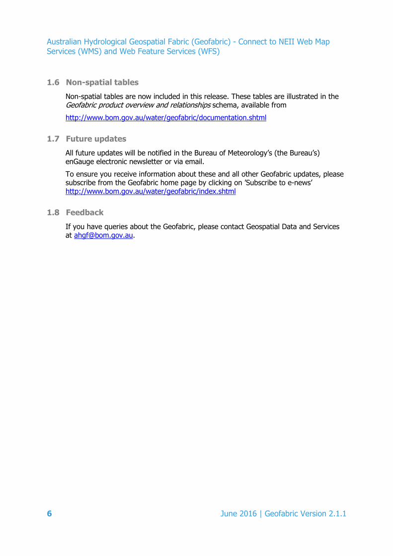
2. Add the Geofabric Surface Cartography – AHGFSea layer as the first Geofabric layer to help navigate and zoom to your area of interest.
Figure 1 - Geofabric Surface Cartography, AHGFSea
Note:
If more than 1 million features are required, please download the Geofabric as ESRI File Geodatabases from http://www.bom.gov.au/water/geofabric/download.shtml
The Geofabric is also available as ESRI Shapefiles on request by emailing [email protected]
June 2016 | Geofabric Version 2.1.1 7
Australian Hydrological Geospatial Fabric (Geofabric) - Connect to NEII Web Map Services (WMS) and Web Feature Services (WFS)
1.9.2 Namespaces, featuretypes
URL requests can be customised to include namespaces (Geofabric products) and featuretypes (Geofabric layers).
1. Retrieve the Geofabric namespaces (Geofabric products) and featuretypes (Geofabric layers) by entering the following URL into a browser http://geofabric.bom.gov.au/simplefeatures/ows?service=WFS&version=1.0.0&request=DescribeFeatureType&typeNames=namespace:featuretype
2. The result will look like this
Namespace Geofabric product ahgf_shcarto Surface Cartography ahgf_shn Surface Network ahgf_shcatch Surface Catchments ahgf_gwc Groundwater Cartography ahgf_hrr Hydrology Reporting Regions ahgf_hrc Hydrology Reporting Catchments
3. Geofabric feature types are illustrated in the Geofabric product overview and relationships schema available from http://www.bom.gov.au/water/geofabric/documentation.shtml
8 June 2016 | Geofabric Version 2.1.1

Australian Hydrological Geospatial Fabric (Geofabric) - Connect to NEII Web Map Services (WMS) and Web Feature Services (WFS)
1.9.3 WMS
Gridsets
The following gridsets are cached in image / png format and image / jpeg, please use these when requesting WMS images:
• EPSG:4283 (GDA94)
Tiles
Set the TILED=true parameter when making WMS GetMap requests to enable caching when using the above gridsets.
Scales
The Geofabric data layers are set to display at various scales to optimise performance for each individual layer. Depending on the GIS software, scales range from approximately 1:20 million to 1:150,000. If data does not display, continue to zoom in.
This scale limit is necessary due to the size of the Geofabric datasets.
Timeout
Timeouts of 60 seconds are set on WMS services to ensure the service is performing. It is suggested that you use a tiled WMS client to guard against timeout errors.
GeoServer WMS reference
Please refer to this page for more information about GeoServer’s WMS requests http://docs.geoserver.org/latest/en/user/services/wms/reference.html
June 2016 | Geofabric Version 2.1.1 9
Australian Hydrological Geospatial Fabric (Geofabric) - Connect to NEII Web Map Services (WMS) and Web Feature Services (WFS)
1.9.4 WFS
This section looks at examples of how to access WFS layers.
STARTINDEX, MAXFEATURES
This example illustrates how to access WFS layers from GIS software.
If a query returns more than 10,000 features, page the results using the GeoServer MAXFEATURES and STARTINDEX vendor parameters.
These URLs can be entered in GIS software as separate WFS URL server connections after which the relevant layer is selected and added to the software’s window.
The two examples show how to retrieve the first 20,000 features using:
• STARTINDEX = 0 and MAXFEATURES = 10000
• STARTINDEX = 10001 and MAXFEATURES = 10000
http://geofabric.bom.gov.au/simplefeatures/ows?service=WFS&request=GetFeature&STARTINDEX=0&MAXFEATURES=10000
http://geofabric.bom.gov.au/simplefeatures/ows?service=WFS&request=GetFeature&STARTINDEX=10001&MAXFEATURES=10000
10 June 2016 | Geofabric Version 2.1.1

Australian Hydrological Geospatial Fabric (Geofabric) - Connect to NEII Web Map Services (WMS) and Web Feature Services (WFS)
Bounding Box
This example illustrates how to access WFS layers from a browser.
To confine the search of features to an area, use the BBOX parameter to define your coordinates which must be entered according to EPSG:4283(GDA94).
Figure 2 - GDA94 graticule
This is an example of a request entered into a browser for ahgf_shn AHGFNetworkStream features over an area near Melbourne http://geofabric.bom.gov.au/simplefeatures/ows?service=WFS&version=1.0.0&request=GetFeature&typeNames=ahgf_shn:AHGFNetworkStream&srsName=EPSG:4283&bbox=144,-38,145,-37
GeoServer WFS reference
Please refer to this page for more information about GeoServer’s WFS requests
http://docs.geoserver.org/latest/en/user/services/wfs/reference.html
June 2016 | Geofabric Version 2.1.1 11
Australian Hydrological Geospatial Fabric (Geofabric) - Connect to NEII Web Map Services (WMS) and Web Feature Services (WFS)
1.9.5 WMS and WFS versions
For more information about versions please refer to the following GeoServer documentation:
WFS basics
http://docs.geoserver.org/latest/en/user/services/wfs/basics.html
WMS basics
http://docs.geoserver.org/latest/en/user/services/wms/basics.html
12 June 2016 | Geofabric Version 2.1.1
Australian Hydrological Geospatial Fabric (Geofabric) - Connect to NEII Web Map Services (WMS) and Web Feature Services (WFS) 2 Connect to WMS and WFS
2.1 Configure a WMS connection
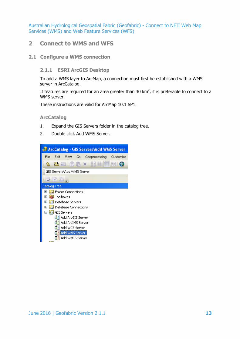
2.1.1 ESRI ArcGIS Desktop
To add a WMS layer to ArcMap, a connection must first be established with a WMS server in ArcCatalog.
If features are required for an area greater than 30 km2, it is preferable to connect to a WMS server.
These instructions are valid for ArcMap 10.1 SP1.
ArcCatalog
1. Expand the GIS Servers folder in the catalog tree.
2. Double click Add WMS Server.
June 2016 | Geofabric Version 2.1.1 13
Australian Hydrological Geospatial Fabric (Geofabric) - Connect to NEII Web Map Services (WMS) and Web Feature Services (WFS)
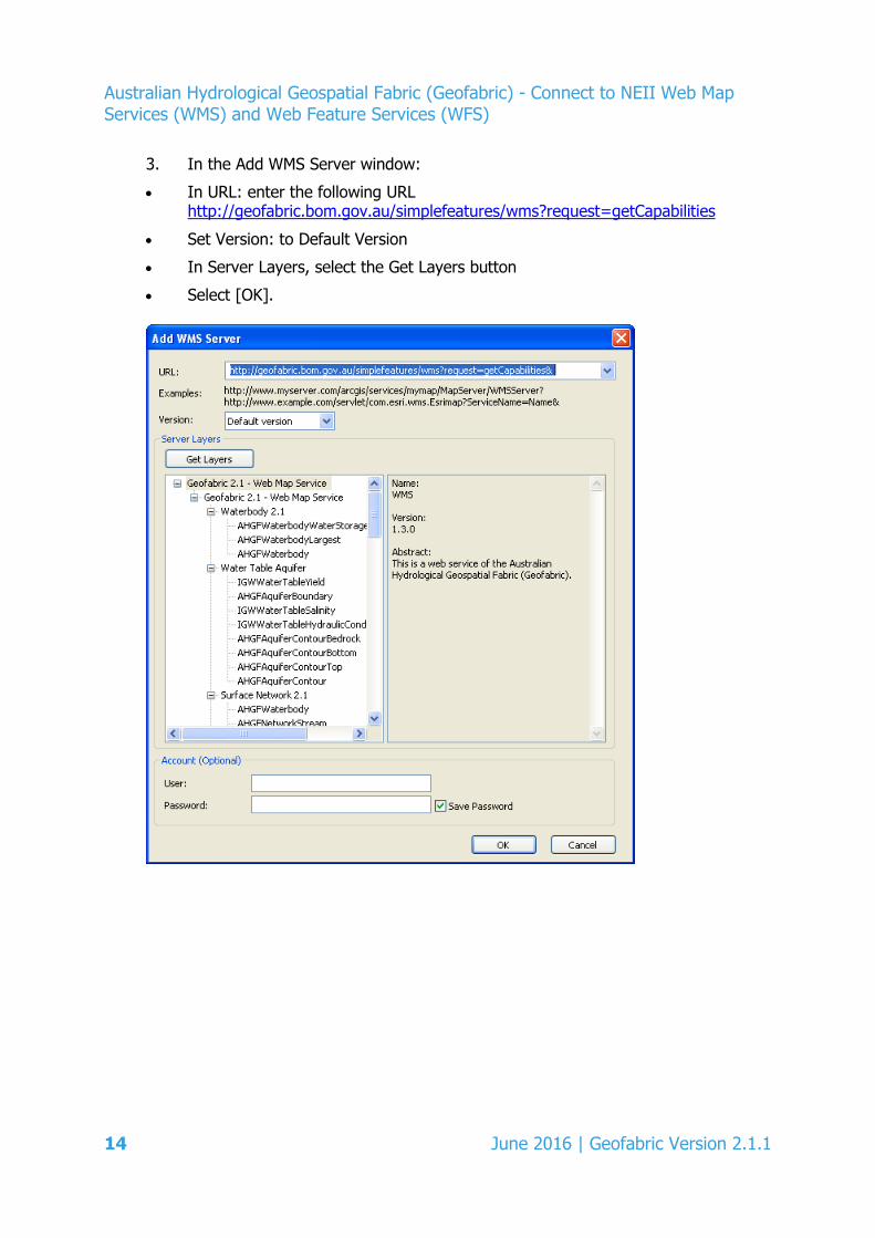
3. In the Add WMS Server window:
• In URL: enter the following URL http://geofabric.bom.gov.au/simplefeatures/wms?request=getCapabilities
• Set Version: to Default Version
• In Server Layers, select the Get Layers button
• Select [OK].
14 June 2016 | Geofabric Version 2.1.1
Australian Hydrological Geospatial Fabric (Geofabric) - Connect to NEII Web Map Services (WMS) and Web Feature Services (WFS)
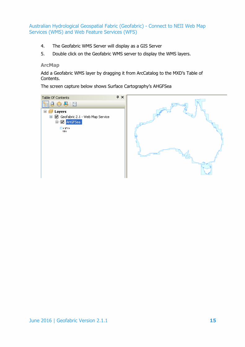
4. The Geofabric WMS Server will display as a GIS Server
5. Double click on the Geofabric WMS server to display the WMS layers. ArcMap Add a Geofabric WMS layer by dragging it from ArcCatalog to the MXD’s Table of Contents.
The screen capture below shows Surface Cartography’s AHGFSea
June 2016 | Geofabric Version 2.1.1 15
Australian Hydrological Geospatial Fabric (Geofabric) - Connect to NEII Web Map Services (WMS) and Web Feature Services (WFS)
2.1.2 MapInfo Pro
MapInfo Pro is a commercial desktop GIS software.
These instructions are valid for MapInfo Pro 15.2.2 (release Build 311).
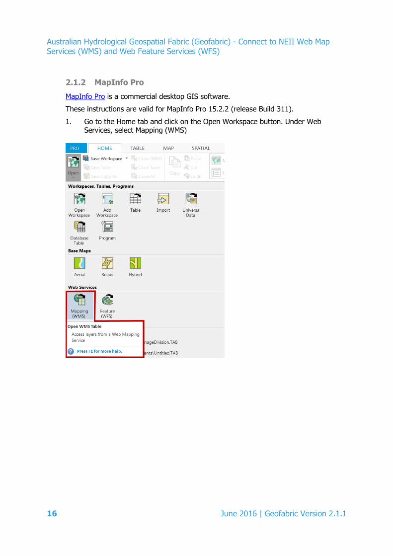
1. Go to the Home tab and click on the Open Workspace button. Under Web Services, select Mapping (WMS)
16 June 2016 | Geofabric Version 2.1.1
Australian Hydrological Geospatial Fabric (Geofabric) - Connect to NEII Web Map Services (WMS) and Web Feature Services (WFS)
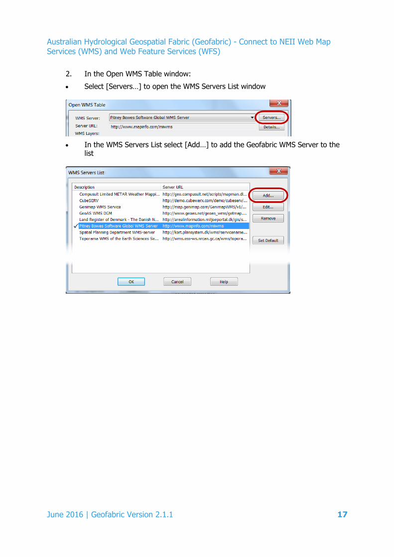
2. In the Open WMS Table window:
• Select [Servers…] to open the WMS Servers List window
• In the WMS Servers List select [Add…] to add the Geofabric WMS Server to the
list
June 2016 | Geofabric Version 2.1.1 17
Australian Hydrological Geospatial Fabric (Geofabric) - Connect to NEII Web Map Services (WMS) and Web Feature Services (WFS)
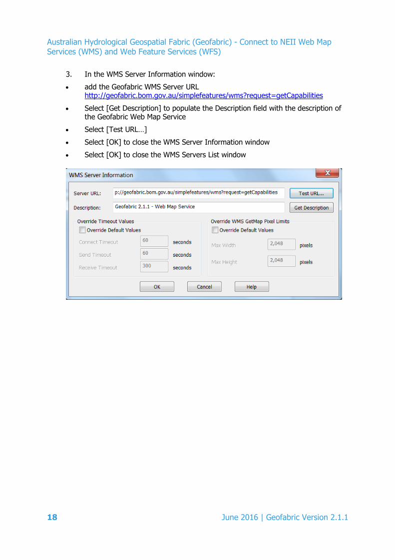
3. In the WMS Server Information window:
• add the Geofabric WMS Server URL http://geofabric.bom.gov.au/simplefeatures/wms?request=getCapabilities
• Select [Get Description] to populate the Description field with the description of the Geofabric Web Map Service
• Select [Test URL…]
• Select [OK] to close the WMS Server Information window
• Select [OK] to close the WMS Servers List window
18 June 2016 | Geofabric Version 2.1.1

Australian Hydrological Geospatial Fabric (Geofabric) - Connect to NEII Web Map Services (WMS) and Web Feature Services (WFS)
4. In the WMS Servers List:
• select the Geofabric 2.1.1 – Web Map Services and select [Set Default]
• Select [OK] to close the WMS Servers List window.
5. In the Open WMS Table window
• select a WMS Layer, for example, scroll down to Surface Cartography and select AHGFSea
• Select [Add>>] to add it to the right pane
• In the Coordinate Reference System section, change the Projection to EPSG:4283
• If required, edit the location and name of the Table Filename, for example, AHGFSea_WMS.TAB
• Select [OK]
June 2016 | Geofabric Version 2.1.1 19
Australian Hydrological Geospatial Fabric (Geofabric) - Connect to NEII Web Map Services (WMS) and Web Feature Services (WFS)
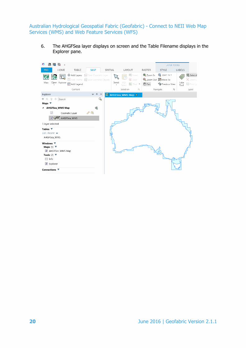
6. The AHGFSea layer displays on screen and the Table Filename displays in the Explorer pane.
20 June 2016 | Geofabric Version 2.1.1
Australian Hydrological Geospatial Fabric (Geofabric) - Connect to NEII Web Map Services (WMS) and Web Feature Services (WFS)
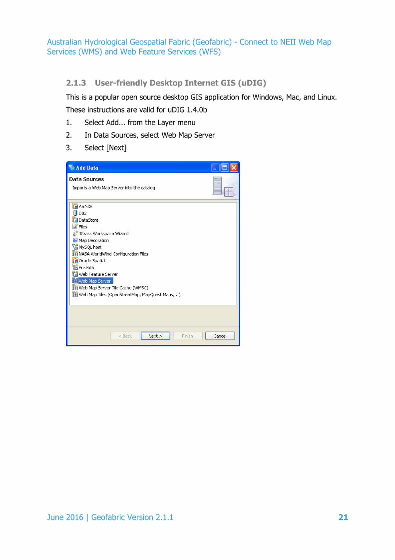
2.1.3 User-friendly Desktop Internet GIS (uDIG)
This is a popular open source desktop GIS application for Windows, Mac, and Linux.
These instructions are valid for uDIG 1.4.0b
1. Select Add... from the Layer menu
2. In Data Sources, select Web Map Server
3. Select [Next]
June 2016 | Geofabric Version 2.1.1 21
Australian Hydrological Geospatial Fabric (Geofabric) - Connect to NEII Web Map Services (WMS) and Web Feature Services (WFS)
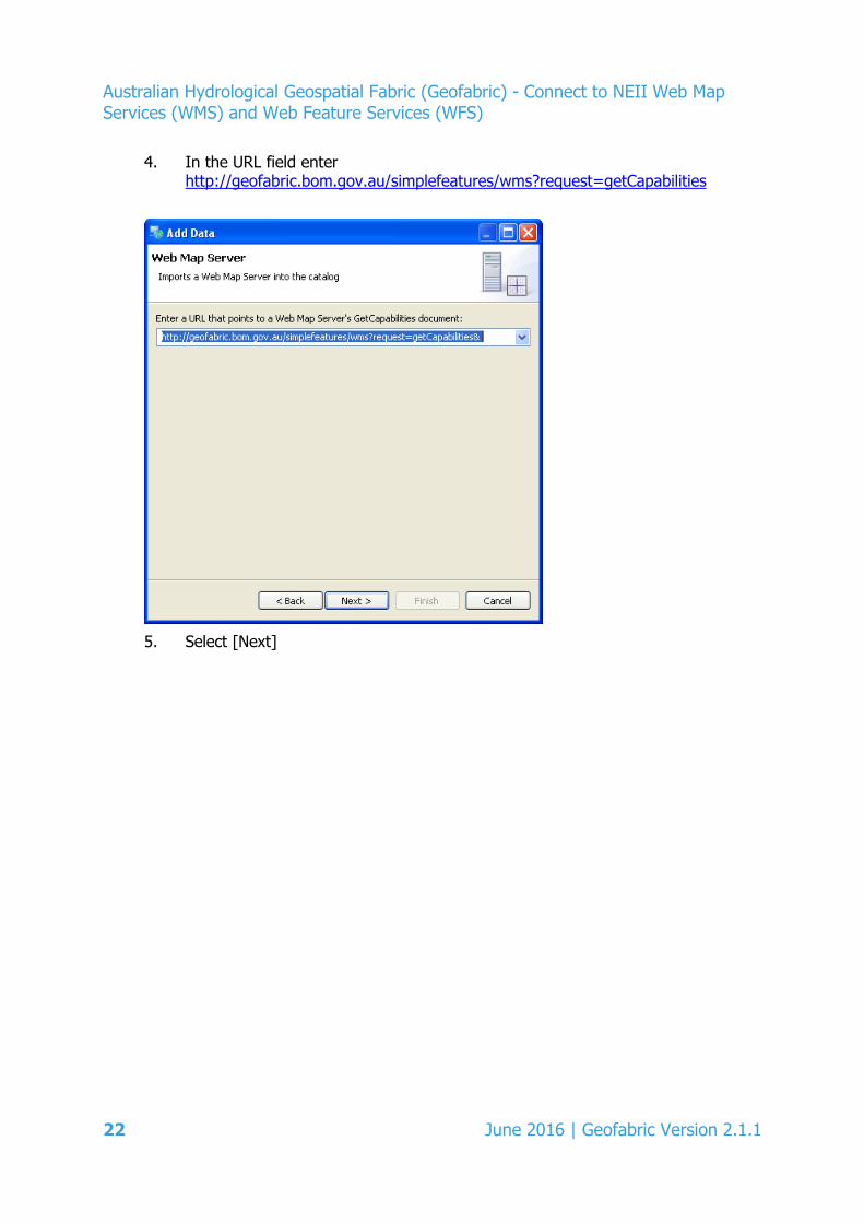
4. In the URL field enter http://geofabric.bom.gov.au/simplefeatures/wms?request=getCapabilities
5. Select [Next]
22 June 2016 | Geofabric Version 2.1.1

Australian Hydrological Geospatial Fabric (Geofabric) - Connect to NEII Web Map Services (WMS) and Web Feature Services (WFS)
6. Select the layer(s) you wish to add from the list
7. Select [Finish].
Note:
If you encounter problems when selecting multiple WMS layers for the same connection, try limiting the number to one or two layers.
June 2016 | Geofabric Version 2.1.1 23
Australian Hydrological Geospatial Fabric (Geofabric) - Connect to NEII Web Map Services (WMS) and Web Feature Services (WFS)
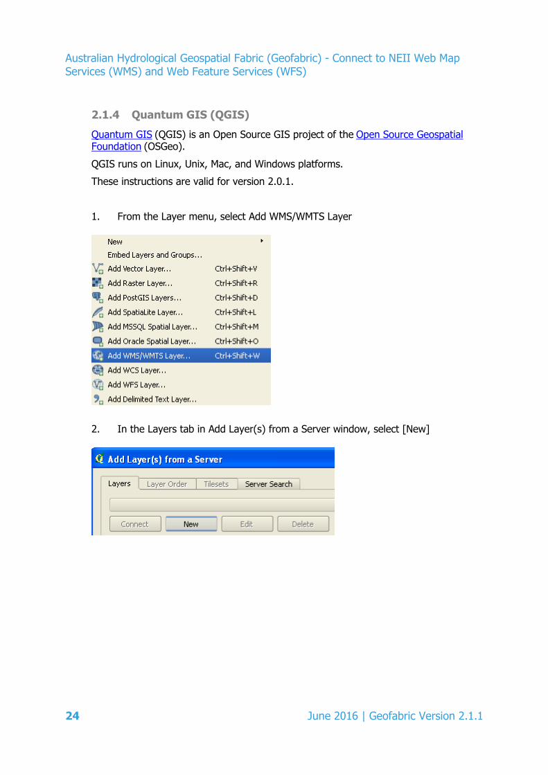
2.1.4 Quantum GIS (QGIS)
Quantum GIS (QGIS) is an Open Source GIS project of the Open Source Geospatial Foundation (OSGeo).
QGIS runs on Linux, Unix, Mac, and Windows platforms.
These instructions are valid for version 2.0.1.
1. From the Layer menu, select Add WMS/WMTS Layer
2. In the Layers tab in Add Layer(s) from a Server window, select [New]
24 June 2016 | Geofabric Version 2.1.1
Australian Hydrological Geospatial Fabric (Geofabric) - Connect to NEII Web Map Services (WMS) and Web Feature Services (WFS)
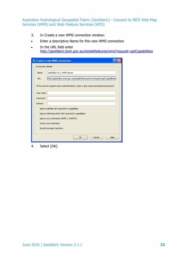
3. In Create a new WMS connection window:
• Enter a descriptive Name for this new WMS connection
• In the URL field enter http://geofabric.bom.gov.au/simplefeatures/wms?request=getCapabilities
4. Select [OK]
June 2016 | Geofabric Version 2.1.1 25
Australian Hydrological Geospatial Fabric (Geofabric) - Connect to NEII Web Map Services (WMS) and Web Feature Services (WFS)
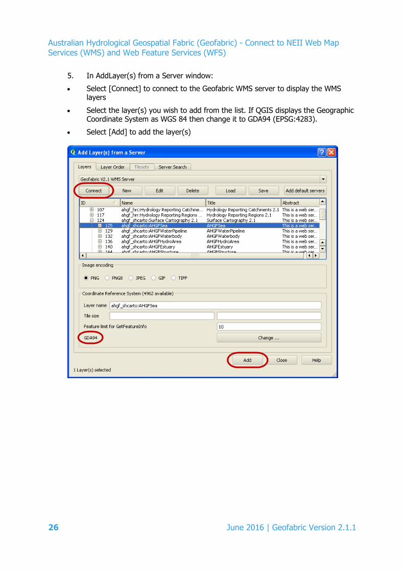
5. In AddLayer(s) from a Server window:
• Select [Connect] to connect to the Geofabric WMS server to display the WMS layers
• Select the layer(s) you wish to add from the list. If QGIS displays the Geographic Coordinate System as WGS 84 then change it to GDA94 (EPSG:4283).
• Select [Add] to add the layer(s)
26 June 2016 | Geofabric Version 2.1.1
Australian Hydrological Geospatial Fabric (Geofabric) - Connect to NEII Web Map Services (WMS) and Web Feature Services (WFS)
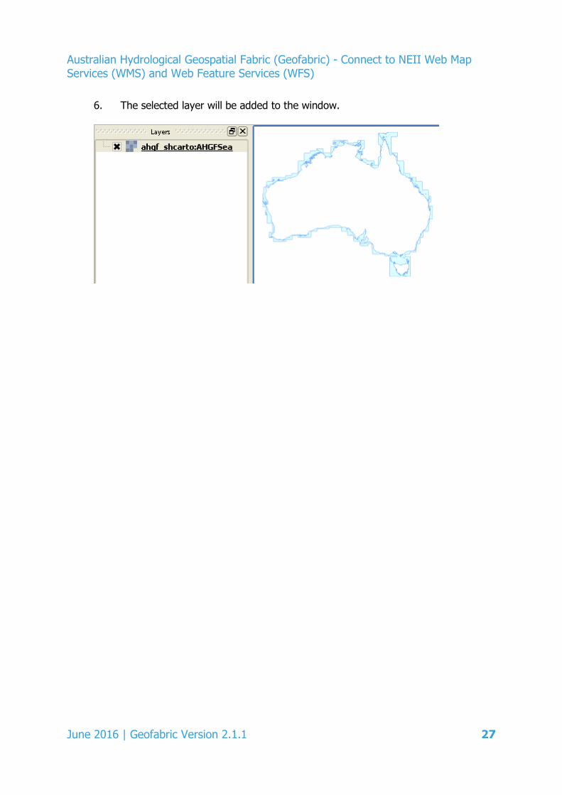
6. The selected layer will be added to the window.
June 2016 | Geofabric Version 2.1.1 27
Australian Hydrological Geospatial Fabric (Geofabric) - Connect to NEII Web Map Services (WMS) and Web Feature Services (WFS)
2.1.5 Google Earth
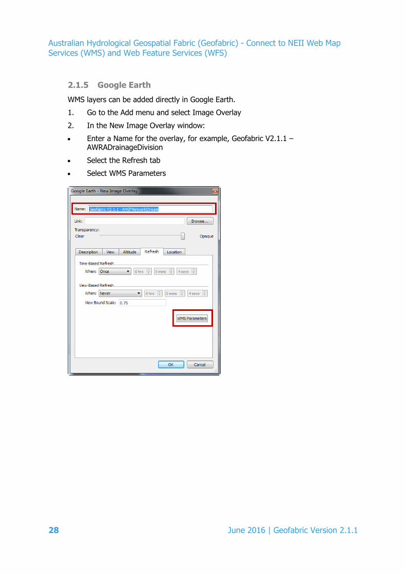
WMS layers can be added directly in Google Earth.
1. Go to the Add menu and select Image Overlay
2. In the New Image Overlay window:
• Enter a Name for the overlay, for example, Geofabric V2.1.1 – AWRADrainageDivision
• Select the Refresh tab
• Select WMS Parameters
28 June 2016 | Geofabric Version 2.1.1
Australian Hydrological Geospatial Fabric (Geofabric) - Connect to NEII Web Map Services (WMS) and Web Feature Services (WFS)
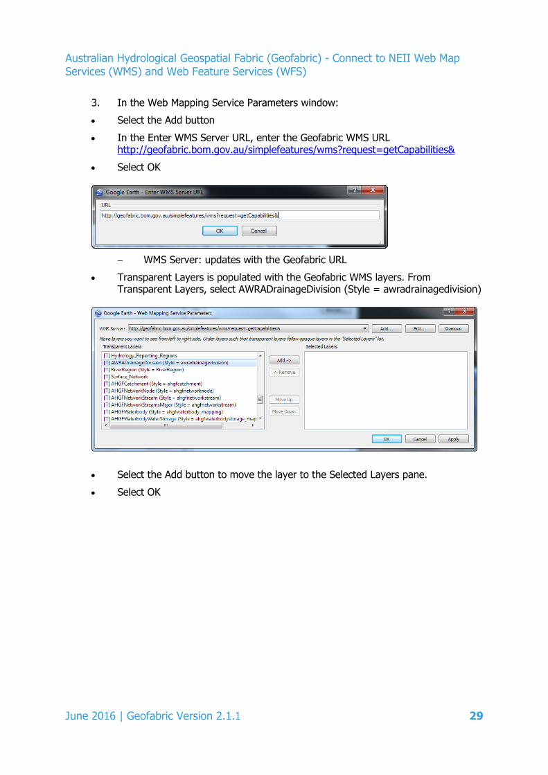
3. In the Web Mapping Service Parameters window:
• Select the Add button
• In the Enter WMS Server URL, enter the Geofabric WMS URL http://geofabric.bom.gov.au/simplefeatures/wms?request=getCapabilities&
• Select OK
− WMS Server: updates with the Geofabric URL
• Transparent Layers is populated with the Geofabric WMS layers. From Transparent Layers, select AWRADrainageDivision (Style = awradrainagedivision)
• Select the Add button to move the layer to the Selected Layers pane.
• Select OK
June 2016 | Geofabric Version 2.1.1 29
Australian Hydrological Geospatial Fabric (Geofabric) - Connect to NEII Web Map Services (WMS) and Web Feature Services (WFS)
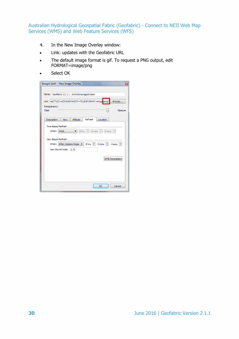
4. In the New Image Overlay window:
• Link: updates with the Geofabric URL
• The default image format is gif. To request a PNG output, edit FORMAT=image/png
• Select OK
30 June 2016 | Geofabric Version 2.1.1
Australian Hydrological Geospatial Fabric (Geofabric) - Connect to NEII Web Map Services (WMS) and Web Feature Services (WFS)
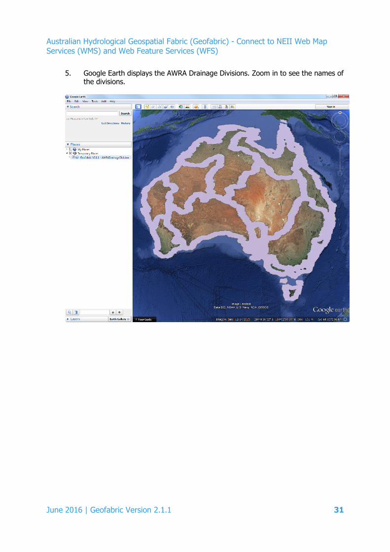
5. Google Earth displays the AWRA Drainage Divisions. Zoom in to see the names of the divisions.
June 2016 | Geofabric Version 2.1.1 31
Australian Hydrological Geospatial Fabric (Geofabric) - Connect to NEII Web Map Services (WMS) and Web Feature Services (WFS)
2.2 Configure a WFS connection
2.2.1 ESRI ArcGIS Desktop
These instructions are valid for 10.3 SP1.
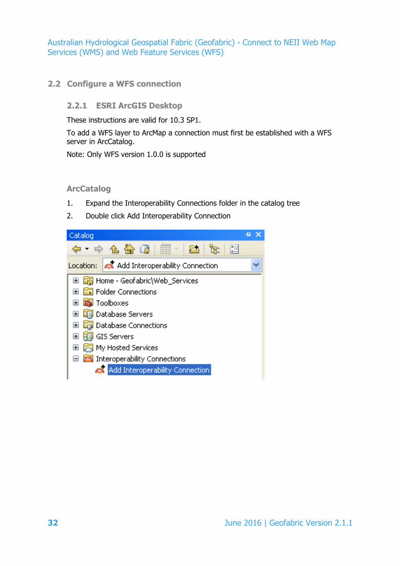
To add a WFS layer to ArcMap a connection must first be established with a WFS server in ArcCatalog.
Note: Only WFS version 1.0.0 is supported
ArcCatalog
1. Expand the Interoperability Connections folder in the catalog tree
2. Double click Add Interoperability Connection
32 June 2016 | Geofabric Version 2.1.1
Australian Hydrological Geospatial Fabric (Geofabric) - Connect to NEII Web Map Services (WMS) and Web Feature Services (WFS)
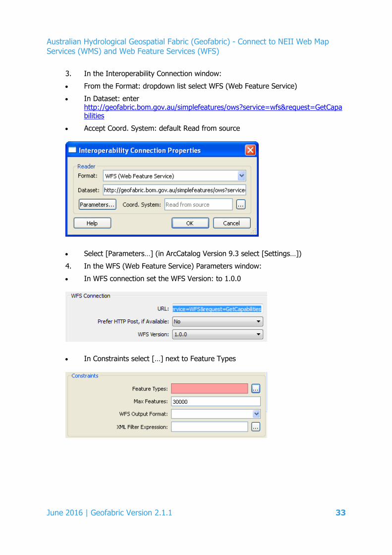
3. In the Interoperability Connection window:
• From the Format: dropdown list select WFS (Web Feature Service)
• In Dataset: enter http://geofabric.bom.gov.au/simplefeatures/ows?service=wfs&request=GetCapabilities
• Accept Coord. System: default Read from source
• Select [Parameters…] (in ArcCatalog Version 9.3 select [Settings…])
4. In the WFS (Web Feature Service) Parameters window:
• In WFS connection set the WFS Version: to 1.0.0
• In Constraints select […] next to Feature Types
June 2016 | Geofabric Version 2.1.1 33
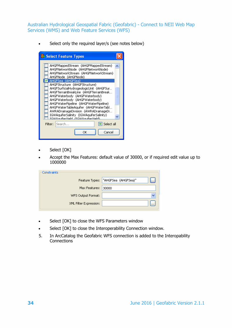
Australian Hydrological Geospatial Fabric (Geofabric) - Connect to NEII Web Map Services (WMS) and Web Feature Services (WFS)
• Select only the required layer/s (see notes below)
• Select [OK]
• Accept the Max Features: default value of 30000, or if required edit value up to 1000000
• Select [OK] to close the WFS Parameters window
• Select [OK] to close the Interoperability Connection window.
5. In ArcCatalog the Geofabric WFS connection is added to the Interopability Connections
34 June 2016 | Geofabric Version 2.1.1

Australian Hydrological Geospatial Fabric (Geofabric) - Connect to NEII Web Map Services (WMS) and Web Feature Services (WFS)
To restrict the number of features to be added, for example AHGFNetworkStream, scroll to the bottom of WFS Parameters and select Use Search Envelope
• Enter XY values in EPSG:4283 (GDA94)
• Select Clip to Search Envelope
• Populate Search Envelope Coordinate System: with EPSG:4283.
6. Select [OK] to close the WFS Parameters window.
7. Select [OK] to close the Interoperability Connection window.
8. Click and drag the selected layer(s) to the Table of Contents.
9. The screen grab below shows the clipped extent of AHGFNetworkStream west of Melbourne. (AHGFSea is included to show the location.)
June 2016 | Geofabric Version 2.1.1 35
Australian Hydrological Geospatial Fabric (Geofabric) - Connect to NEII Web Map Services (WMS) and Web Feature Services (WFS)
Notes:
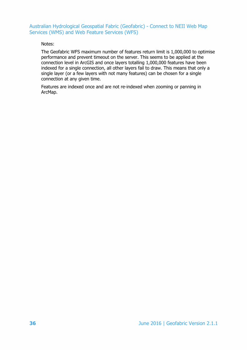
The Geofabric WFS maximum number of features return limit is 1,000,000 to optimise performance and prevent timeout on the server. This seems to be applied at the connection level in ArcGIS and once layers totalling 1,000,000 features have been indexed for a single connection, all other layers fail to draw. This means that only a single layer (or a few layers with not many features) can be chosen for a single connection at any given time. Features are indexed once and are not re-indexed when zooming or panning in ArcMap.
36 June 2016 | Geofabric Version 2.1.1
Australian Hydrological Geospatial Fabric (Geofabric) - Connect to NEII Web Map Services (WMS) and Web Feature Services (WFS)
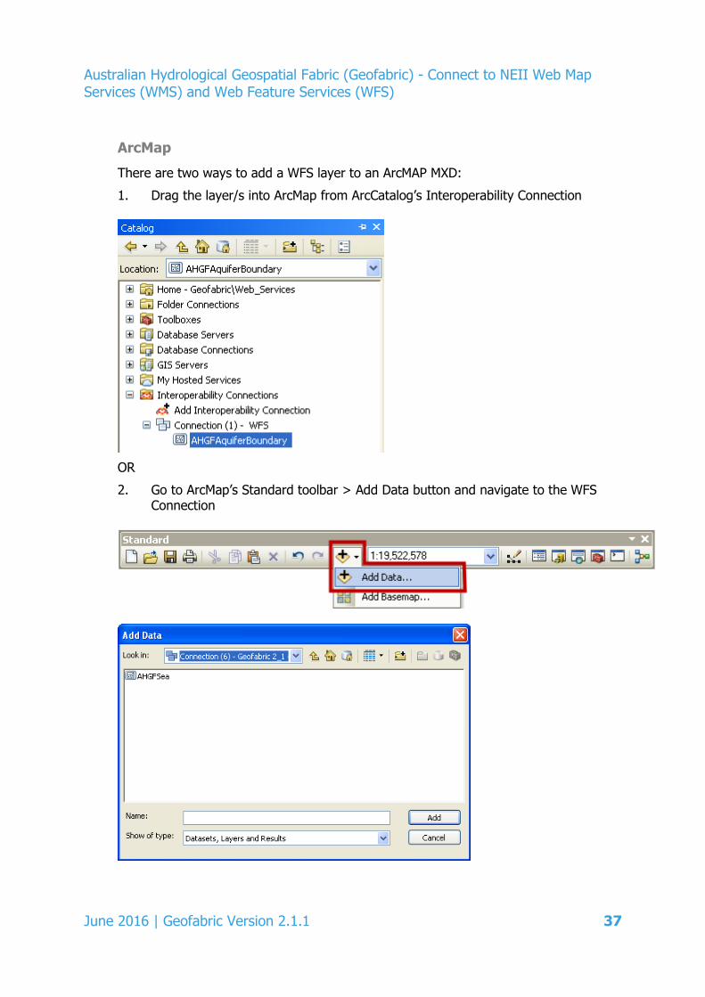
ArcMap
There are two ways to add a WFS layer to an ArcMAP MXD:
1. Drag the layer/s into ArcMap from ArcCatalog’s Interoperability Connection
OR
2. Go to ArcMap’s Standard toolbar > Add Data button and navigate to the WFS Connection
June 2016 | Geofabric Version 2.1.1 37
Australian Hydrological Geospatial Fabric (Geofabric) - Connect to NEII Web Map Services (WMS) and Web Feature Services (WFS)
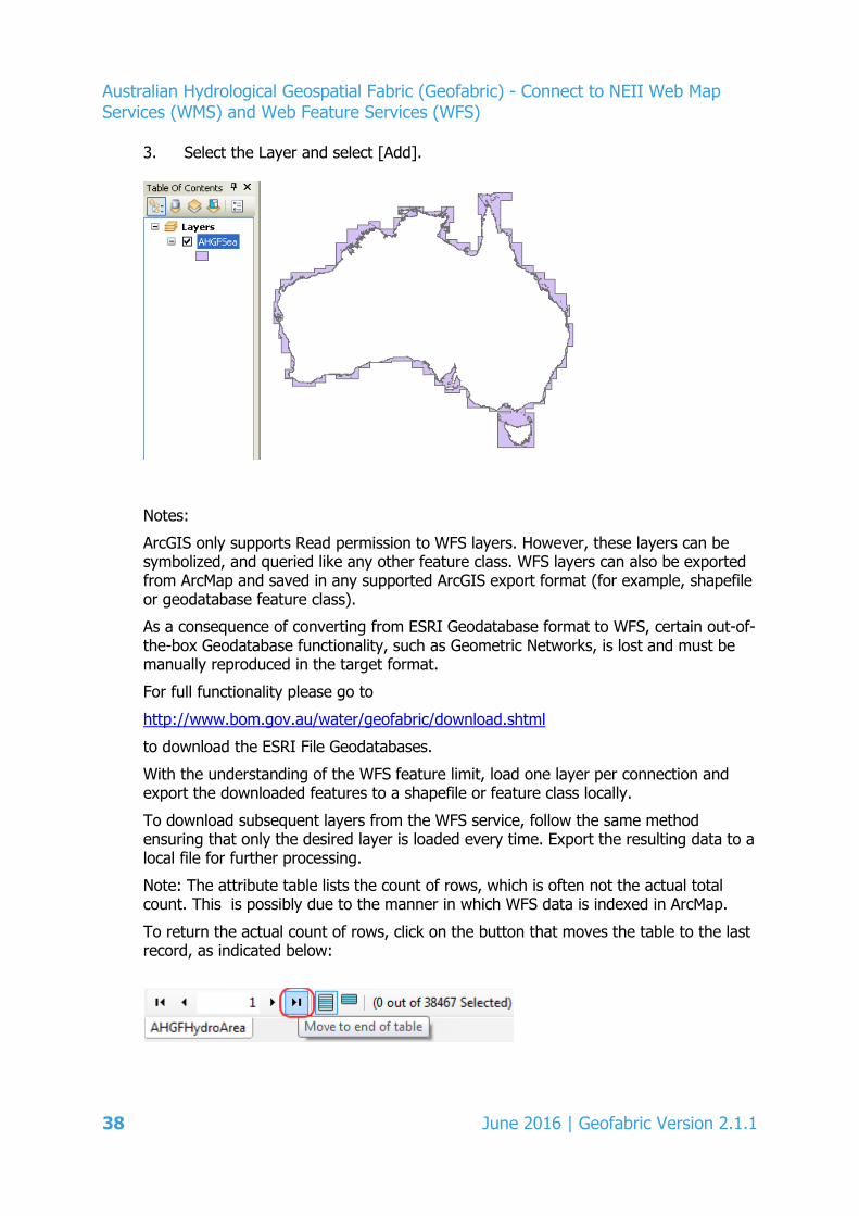
3. Select the Layer and select [Add].
Notes:
ArcGIS only supports Read permission to WFS layers. However, these layers can be symbolized, and queried like any other feature class. WFS layers can also be exported from ArcMap and saved in any supported ArcGIS export format (for example, shapefile or geodatabase feature class).
As a consequence of converting from ESRI Geodatabase format to WFS, certain out-of-the-box Geodatabase functionality, such as Geometric Networks, is lost and must be manually reproduced in the target format.
For full functionality please go to
http://www.bom.gov.au/water/geofabric/download.shtml
to download the ESRI File Geodatabases.
With the understanding of the WFS feature limit, load one layer per connection and export the downloaded features to a shapefile or feature class locally.
To download subsequent layers from the WFS service, follow the same method ensuring that only the desired layer is loaded every time. Export the resulting data to a local file for further processing.
Note: The attribute table lists the count of rows, which is often not the actual total count. This is possibly due to the manner in which WFS data is indexed in ArcMap.
To return the actual count of rows, click on the button that moves the table to the last record, as indicated below:
38 June 2016 | Geofabric Version 2.1.1
Australian Hydrological Geospatial Fabric (Geofabric) - Connect to NEII Web Map Services (WMS) and Web Feature Services (WFS)
2.2.2 MapInfo Pro
MapInfo Pro is a commercial desktop GIS software.
These instructions are valid for MapInfo Pro 15.2.2 (release Build 311).
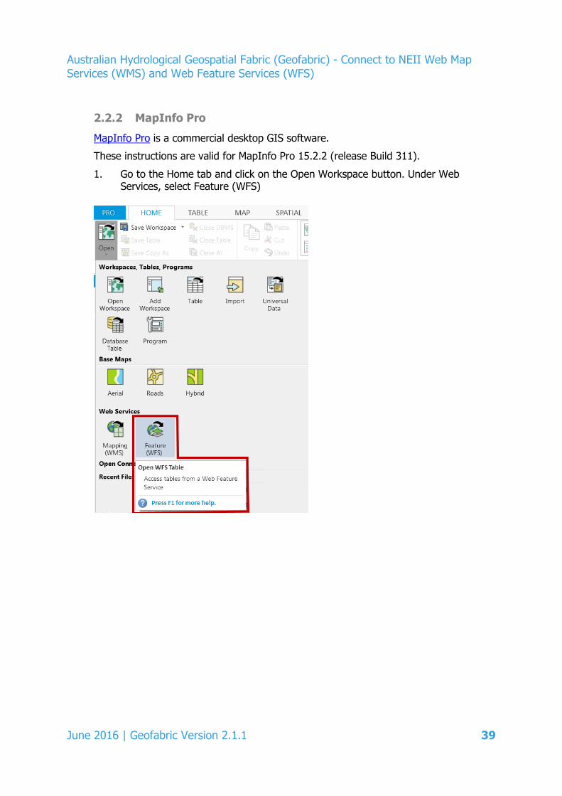
1. Go to the Home tab and click on the Open Workspace button. Under Web Services, select Feature (WFS)
June 2016 | Geofabric Version 2.1.1 39
Australian Hydrological Geospatial Fabric (Geofabric) - Connect to NEII Web Map Services (WMS) and Web Feature Services (WFS)
2. In the Open WFS Table window:
• Select [Servers..] to open the WFS Servers List
• Select [Add…] to add the Geofabric WFS Server to the list
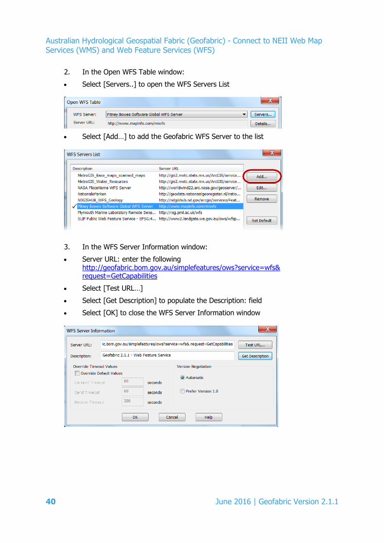
3. In the WFS Server Information window:
• Server URL: enter the following http://geofabric.bom.gov.au/simplefeatures/ows?service=wfs& request=GetCapabilities
• Select [Test URL…]
• Select [Get Description] to populate the Description: field
• Select [OK] to close the WFS Server Information window
40 June 2016 | Geofabric Version 2.1.1
Australian Hydrological Geospatial Fabric (Geofabric) - Connect to NEII Web Map Services (WMS) and Web Feature Services (WFS)
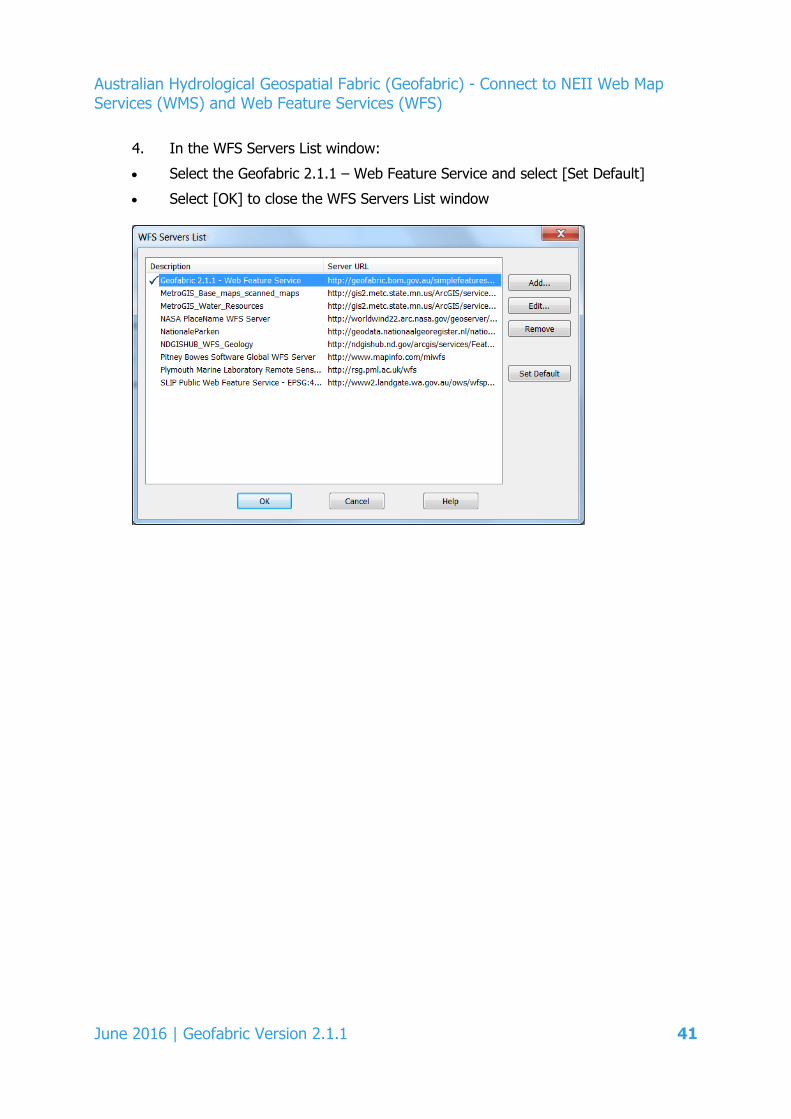
4. In the WFS Servers List window:
• Select the Geofabric 2.1.1 – Web Feature Service and select [Set Default]
• Select [OK] to close the WFS Servers List window
June 2016 | Geofabric Version 2.1.1 41
Australian Hydrological Geospatial Fabric (Geofabric) - Connect to NEII Web Map Services (WMS) and Web Feature Services (WFS)
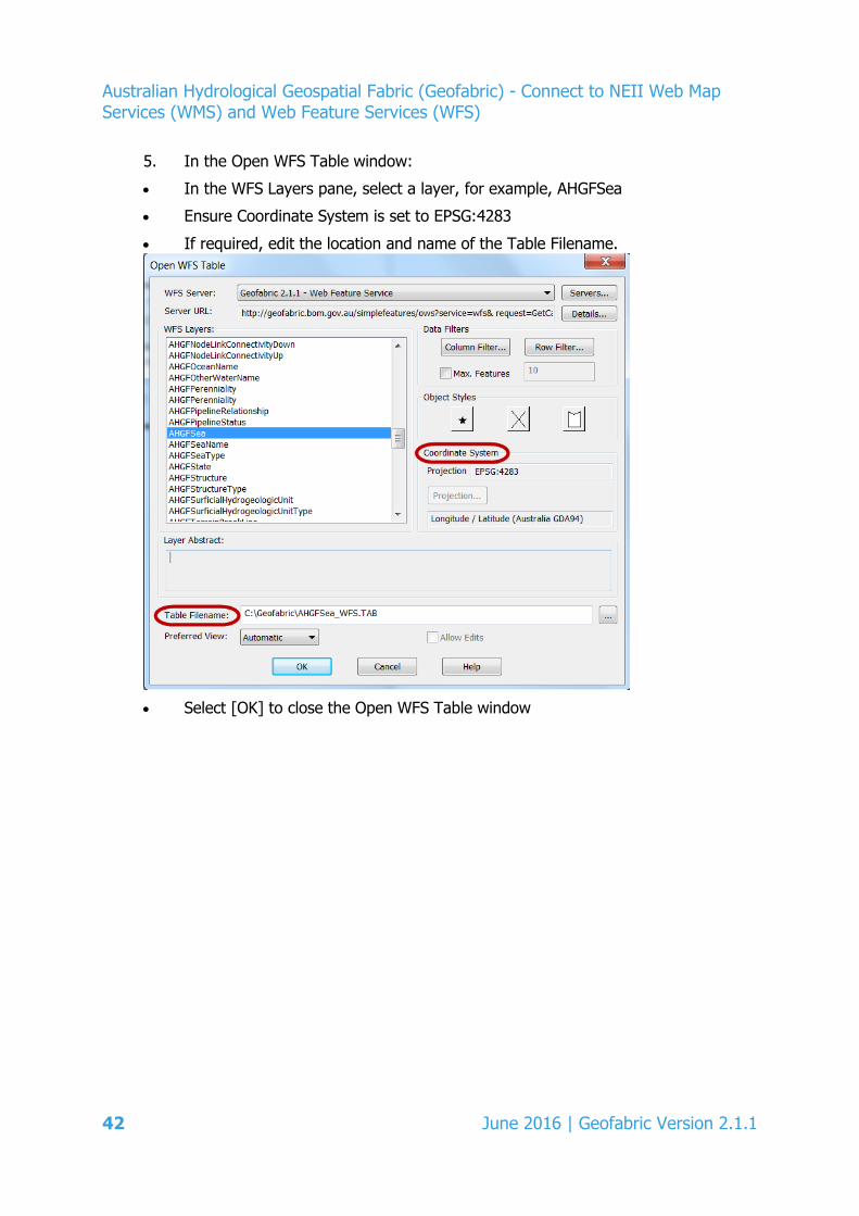
5. In the Open WFS Table window:
• In the WFS Layers pane, select a layer, for example, AHGFSea
• Ensure Coordinate System is set to EPSG:4283
• If required, edit the location and name of the Table Filename.
• Select [OK] to close the Open WFS Table window
42 June 2016 | Geofabric Version 2.1.1
Australian Hydrological Geospatial Fabric (Geofabric) - Connect to NEII Web Map Services (WMS) and Web Feature Services (WFS)
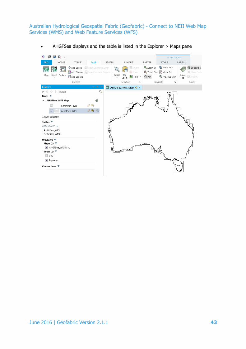
• AHGFSea displays and the table is listed in the Explorer > Maps pane
June 2016 | Geofabric Version 2.1.1 43

Australian Hydrological Geospatial Fabric (Geofabric) - Connect to NEII Web Map Services (WMS) and Web Feature Services (WFS)
2.2.3 User-friendly Desktop Internet GIS (uDIG)
uDIG is a popular open source desktop GIS application for Windows, Mac, and Linux.
These instructions are valid for 1.4.
1. From the Layer menu select Add…
2. In the Add Data window, select Web Feature Server, then select [Next]
44 June 2016 | Geofabric Version 2.1.1
Australian Hydrological Geospatial Fabric (Geofabric) - Connect to NEII Web Map Services (WMS) and Web Feature Services (WFS)
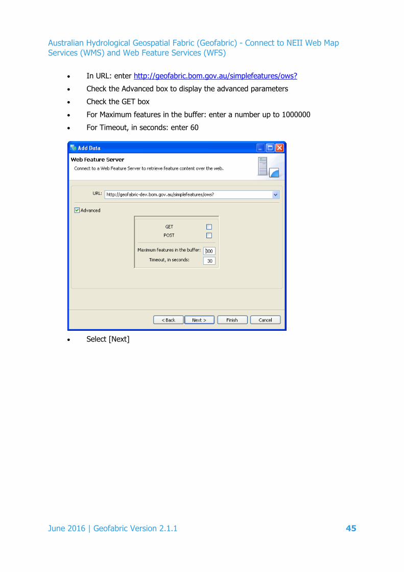
• In URL: enter http://geofabric.bom.gov.au/simplefeatures/ows?
• Check the Advanced box to display the advanced parameters
• Check the GET box
• For Maximum features in the buffer: enter a number up to 1000000
• For Timeout, in seconds: enter 60
• Select [Next]
June 2016 | Geofabric Version 2.1.1 45
Australian Hydrological Geospatial Fabric (Geofabric) - Connect to NEII Web Map Services (WMS) and Web Feature Services (WFS)
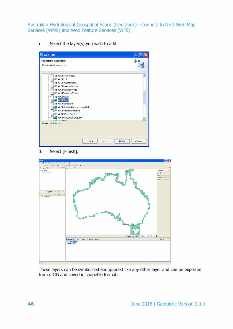
• Select the layer(s) you wish to add
3. Select [Finish].
These layers can be symbolised and queried like any other layer and can be exported from uDIG and saved in shapefile format.
46 June 2016 | Geofabric Version 2.1.1
Australian Hydrological Geospatial Fabric (Geofabric) - Connect to NEII Web Map Services (WMS) and Web Feature Services (WFS)
2.2.4 Quantum GIS (QGIS)
Quantum GIS (QGIS) is an Open Source GIS project of the Open Source Geospatial Foundation (OSGeo). QGIS runs on Linux, Unix, Mac, and Windows platforms.
The following instructions are valid for QGIS 2.0.1-Dufour.
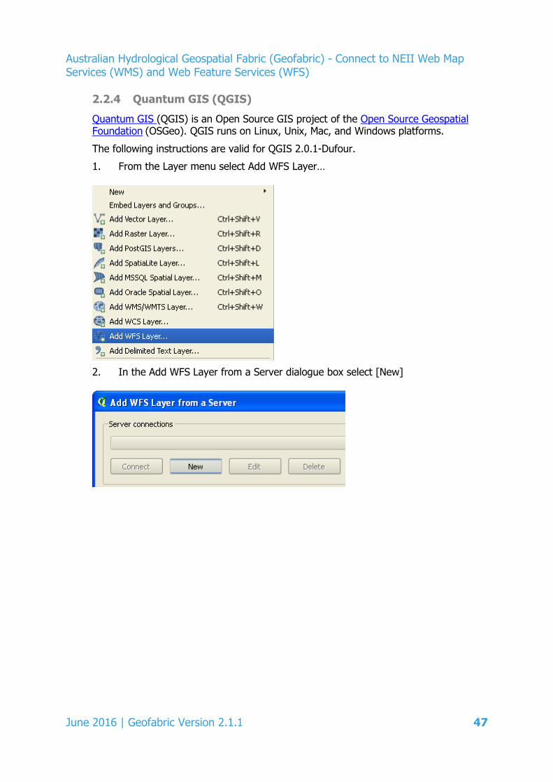
1. From the Layer menu select Add WFS Layer…
2. In the Add WFS Layer from a Server dialogue box select [New]
June 2016 | Geofabric Version 2.1.1 47

Australian Hydrological Geospatial Fabric (Geofabric) - Connect to NEII Web Map Services (WMS) and Web Feature Services (WFS)
3. In the Create a new WFS connection window
• Enter an appropriate Name
• In URL enter http://geofabric.bom.gov.au/simplefeatures/ows?
• Select [OK]
4. In the Add WFS Layer from a Server window,
• Select [Connect]
• Select a WFS layer
• Ensure that the Coordinate Reference System is set to EPSG:4283 (GDA94)
48 June 2016 | Geofabric Version 2.1.1
Australian Hydrological Geospatial Fabric (Geofabric) - Connect to NEII Web Map Services (WMS) and Web Feature Services (WFS)
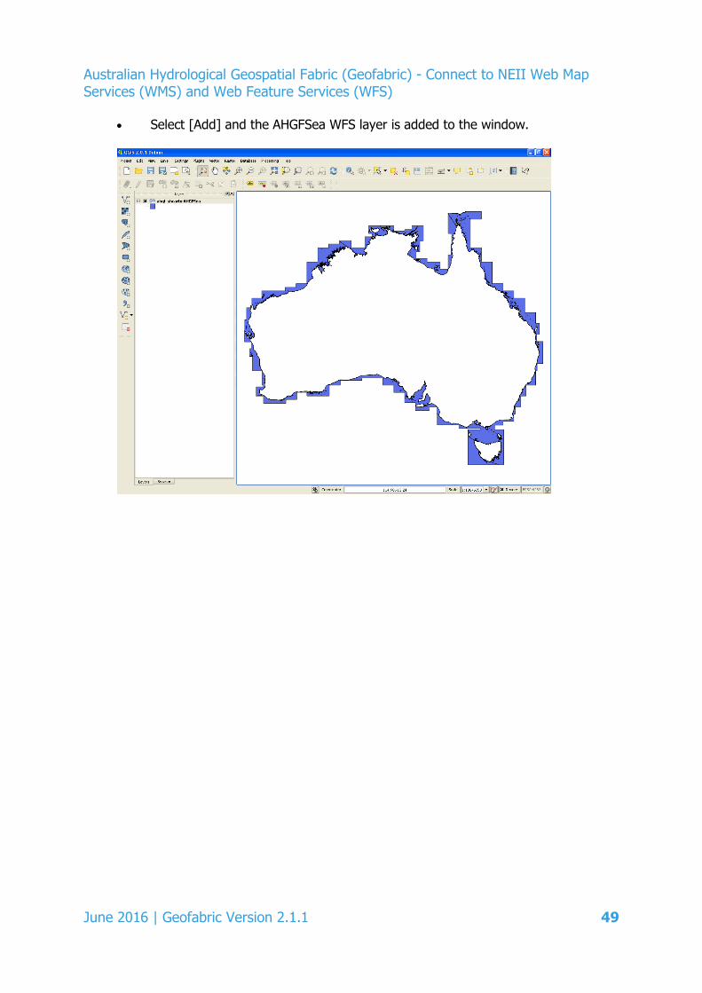
• Select [Add] and the AHGFSea WFS layer is added to the window.
June 2016 | Geofabric Version 2.1.1 49
Through the Water Act 2007, the Australian Government has given the Bureau of Meteorology responsibility for compiling and delivering comprehensive water information across Australia.
For more information Visit our website at www.bom.gov.au/water Send an email request to [email protected]


