32
Australia’s science -to-policy modelling platform Robert Carr Deputy CEO

Australia’s science-to-policy modelling platform
Robert Carr
Deputy CEO
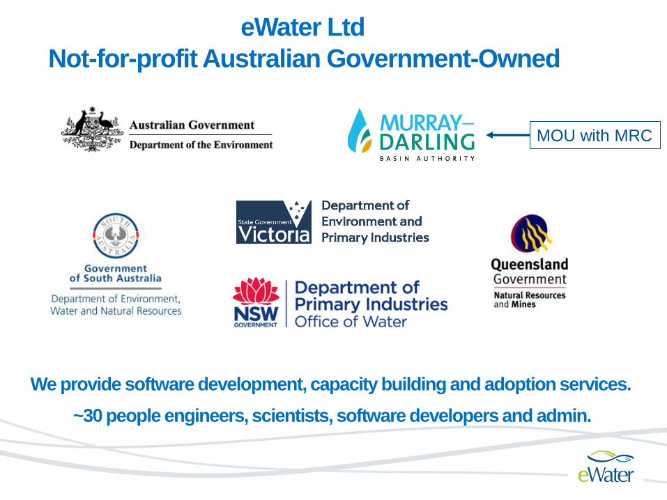
eWater Ltd
Not-for-profit Australian Government-Owned
We provide software development, capacity building and adoption services.
~30 people engineers, scientists, software developers and admin.
MOU with MRC
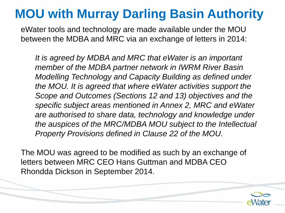
MOU with Murray Darling Basin AuthorityeWater tools and technology are made available under the MOU
between the MDBA and MRC via an exchange of letters in 2014:
It is agreed by MDBA and MRC that eWater is an important
member of the MDBA partner network in IWRM River Basin
Modelling Technology and Capacity Building as defined under
the MOU. It is agreed that where eWater activities support the
Scope and Outcomes (Sections 12 and 13) objectives and the
specific subject areas mentioned in Annex 2, MRC and eWater
are authorised to share data, technology and knowledge under
the auspices of the MRC/MDBA MOU subject to the Intellectual
Property Provisions defined in Clause 22 of the MOU.
The MOU was agreed to be modified as such by an exchange of
letters between MRC CEO Hans Guttman and MDBA CEO
Rhondda Dickson in September 2014.

A new modelling capability for Australia
A realisation that earlier generation tools (IQQM, REALM & BIGMOD)
would struggle to handle 21Century water management complexity
• Increased Water Policy and Governance Expectations
• Focus on water use efficiency (eg. tradeable rights, environ. water)
• Ecological outcomes and Climate uncertainty
• Generational Change in Software Development
Released in 2012, eWater Source is a nationally consistent
forecasting and planning capability, integrating:
• Balancing human and environmental needs
• Conjunctive surface and groundwater use
• Rural and urban supply
• Water use and reuse
• Planning and operational requirements
• Managing Water Accounting and Sharing

Adaptive Complexity.
Matching models, data and outcomes (e.g. as study becomes
more complex, use more complex models)
Flexibility – foster research and address uncertainty
No one right solution – multiple options (e.g. all models are
approximations )
Openness and Community
Collaborative approach to development and access (e.g. free,
open development platform)
Defensible
Good/Best Practice - Tools and Applications (Good Practice
Guidelines)
Guiding Principles for Modelling

Energy Sector
DAMS & WEIRS
IRRIGATIONDemand
Demand
Demand
CITIES
Runoff = Supply
eWater Source – integrated supply and demand of water quantity and quality - local to basin scale
Groundwater = Supply
Fisheries and Wetlands

Major Features Comparison with IQQM
1. Water Quality - Multiple Species with Filtering & Decay (upgraded from IQQM)
2. Multiple Crop and Urban models for demand estimation
3. Incorporation of Environmental Demands (informed by outside process i.e. DRIFT)
4. Surface/Groundwater interaction incl. groundwater head and floodplain recharge
5. NETLP for Multi-Reservoir Operation
6. Genetic Algorithm Optimisation Tools for Tradeoff Analysis
7. River Cross-Sections, Flood Damage and Rating Curves
8. Operational Capability – forecasting of flows in short/medium/long term
9. Multiple Rainfall runoff models - Regionalisation methods (for ungauged catchments
and different land use types) Stochastic procedures (for rainfall inflows)
10. Object Code C#/.NET and Cloud Enabled
11. Plugins, FEWS Adapter/Interface
12. Auto Calibration Tool
13. TIME Library integration
14. Input/output data standards (compliant with WDTF, Hydsys, SQL, Oracle, etc.)
15. Documentation
• Up to date user guide with context-sensitive help (on-line version)
• Up to date technical reference manual
• Training Videos
• Best Practice Guidelines
• Community of Practice, Knowledge Forums and FAQ

River Manager Mode Nodes representing points
of interest, physical and
management
characteristics

5 Catchment Export
Methods
3 link decay models 11 link routing
models
Source as Integration Framework
Enhances DSF Capability11 Catchment
Runoff models
WUP-FIN
SWAT (incl. 2-way
communication
DRIFT -> Environmental
Demands
WUP-FIN
SWAT
WUP-FIN
SWAT(incl. 2-way
communication
WUP-FIN +

Physical, Chemical,
Economic & Social
Sub-Catchment
Catchment
River Basin
IWRM
Sources: Surface, Groundwater, Desal, Recycled etc…
Sectors: Hydropower, Irrigation, Urban, Environmental, etc…
Political, Legal &
Agency Divisions
Municipality
Province
State
Transboundary

Scenario Comparison
Multiple Operational or Planning Horizon Configurations
High Demand Wet
Weather Operations -
30% Probability
High Demand Normal
Operations – 20%
Probability
High Demand
Maintenance of Tanks
– 50% Probability
e.g. Strategy to provide 95% reliability
of supply over forecast period
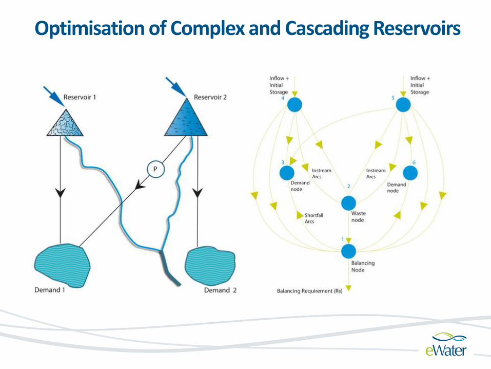
Optimisation of Complex and Cascading Reservoirs
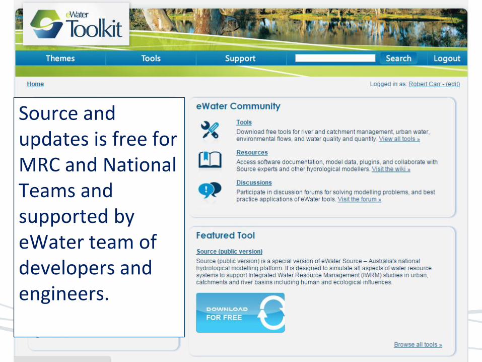
Source and updates is free for MRC and National Teams and supported by eWater team of developers and engineers.

• 2013 Pilot to demonstrate same as IQQM
• Support for PWUM
• Support for Hydrology Component
• Support for Council Study
eWater Tools to Support MRC Programs

Comparison Source and IQQM - 3S Pilot
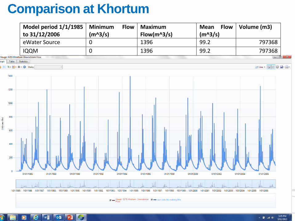
Comparison at Khortum
Model period 1/1/1985 to 31/12/2006
Minimum Flow (m^3/s)
Maximum Flow(m^3/s)
Mean Flow (m^3/s)
Volume (m3)
eWater Source 0 1396 99.2 797368
IQQM 0 1396 99.2 797368

PWUM - eWater Source
On 24th October 2013, the Regional Consultative Meeting on
Implementation of PWUM held at Vientiane, Lao PDR a
number of recommendations were made related to modelling
tools to support PWUM.
1. As a complementary tool to DSF, eWater Source was
proposed to estimate water use in the proposed pilot
area.
2. The detailed information of using eWater Source for
water use estimation should be provided.
3. The training facility and timeframe for eWater Source
should be considered.
4. A comparison study on water use estimation using DSF
and eWater Source should be conducted.
5. It is highly recommended that IKMP TACT is the most
appropriate forum for a discussion on the proposed tool.

eWater and LNMC – Modelling of SeDon Catchment
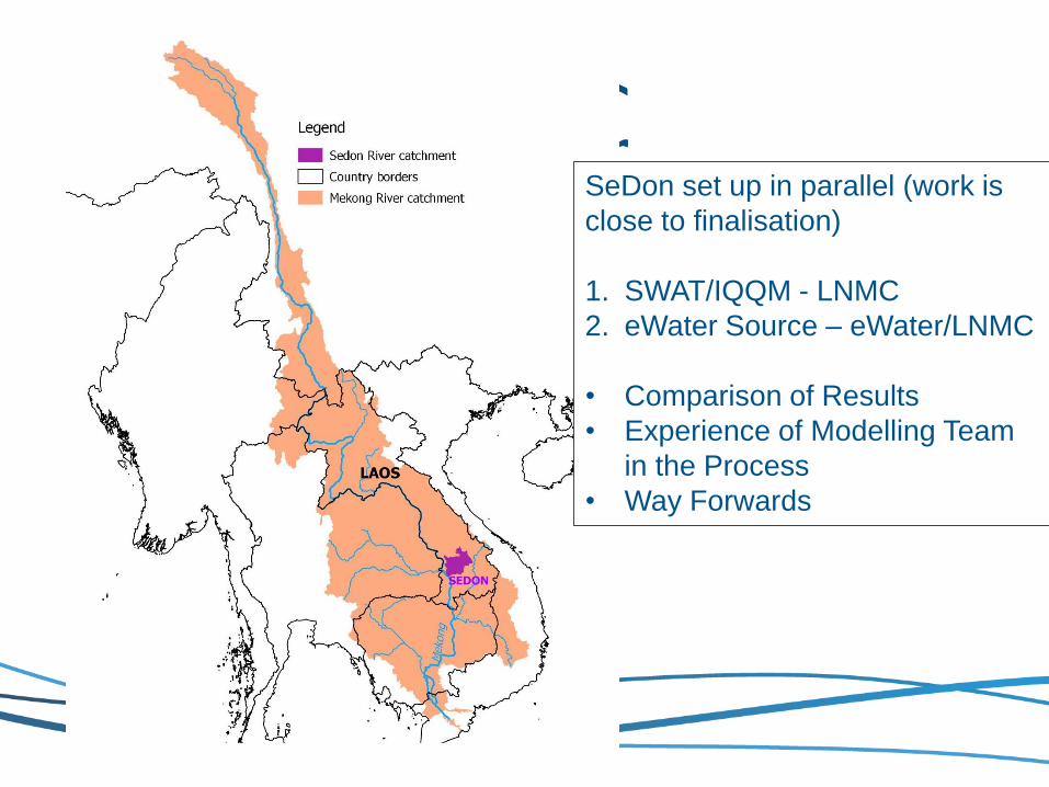
SeDon set up in parallel (work is
close to finalisation)
1. SWAT/IQQM - LNMC
2. eWater Source – eWater/LNMC
• Comparison of Results
• Experience of Modelling Team
in the Process
• Way Forwards

• Digital Elevation Model (create catchments)
• Land Use Data (5 land uses)
• Rainfall Stations (8), Evaporation (2)
• Stream Gauging (3)
• Reservoir Dimensions and Rule Curve (2)
• 34 Water Users - Crop Patterns (from IQQM)
• 2 training sessions (1 week each in 2014) more planned
for 2015
Basic Data Sets and Capacity Building

Source Catchments Setup

Storage
Water User
Environmental
Demand or
Hydropower
Catchment inflow

Nash-Sutcliffe on
Log Flows to
focus on low flow
performance
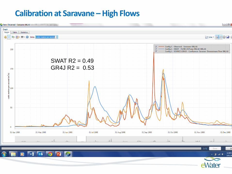
Calibration at Saravane –High Flows
SWAT R2 = 0.49
GR4J R2 = 0.53

Low Flow Analysis at Saravane – Important for PWUM
Flow Exceeded
%of time
GR4J
Data
SWAT

Next Steps
Develop PWUM Water Account Similar to MDBA
Good Practice Guidelines Modelling and Data
Define Supply and
Demand by Location
and Sector as standard
report
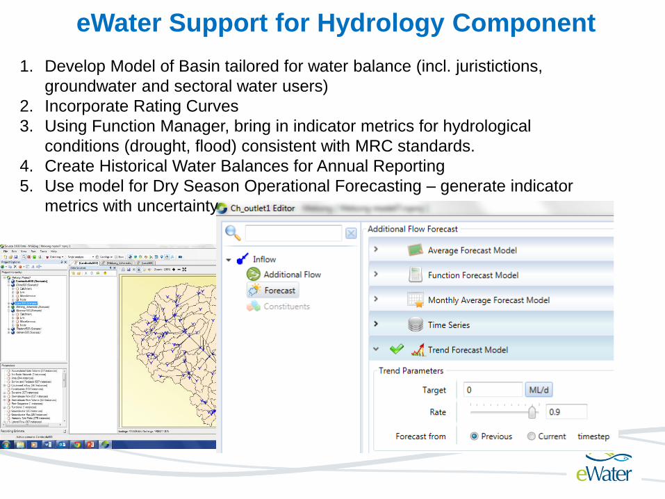
eWater Support for Hydrology Component
1. Develop Model of Basin tailored for water balance (incl. juristictions,
groundwater and sectoral water users)
2. Incorporate Rating Curves
3. Using Function Manager, bring in indicator metrics for hydrological
conditions (drought, flood) consistent with MRC standards.
4. Create Historical Water Balances for Annual Reporting
5. Use model for Dry Season Operational Forecasting – generate indicator
metrics with uncertainty


eWater Support for PWUM & Hydrology Program
eWater in partnership with IKMP & ICBP will develop and implement capacity
building and technology transfer support to MRC and Member Countries in the
following ways:
1. Initially, a regional workshop involving senior modellers from MRCS and
the Country modelling teams will be held to demonstrate the proposed
approach to PWUM & Hydrology Component. This workshop would be
prepared for and with National Mekong Committees and Secretariats, Line
Agencies and the MRC Secretariat;
2. Implement a series of Regional Introduction Meetings, Regional & National
Training workshops and Technical Support in consultation with ICBP, IKMP
and eWater to enhance the capability of the Mekong River modelling
community for the ongoing use of eWater tools for PWUM & Hydrology
Component
3. eWater will provide in-house technical support to IKMP on modelling
approaches, integration of Source with the DSF and working with IKMP
modelling team to provide workshops and training courses in Source to
PWUM and other components and programs as may request assistance.

eWater Source Modelling to Support
Council Study
• Source as integration framework within DSF combining
impact tools with Extended Toolbox Models (SWAT and
ISIS, IWRM and VMOD)
• Analyse Multi-Reservoir Operation – Can augment IQQM
• Incorporate Environmental Flows (inform from DRIFT and
Fisheries)
• Address impact of agreements and water source rights
on strategies
• Evaluate scenarios and tradeoffs

Proposal to TACT:
1. Acknowledge eWater Source as progressive
successor to IQQM and available via the MOU
with MDBA
2. Agreement on the use of eWater Source as an
additional approved tool for PWUM pilot
studies and Hydrology Component
3. Acknowledge that eWater Source is
recommended as a tool by TACT available to
the Council Study subject to review and
approval by RTWG.


