-BD 179 361 AUTHOR. TITLE INSTITUTION SPONS GENCY epUB DATE GRANT NOTE EDRS PRICE DESCRIPTORS DOCONENT ISSUE SI 028 777 Boyer, Rotert: And Others Environmental Studies Section I: Man's Effect on tan-d- Stixdy Guide and Script. Texas Univ.., Austin. Del:it. of Geological Sciences.; Texas Univ., Austin. Science Education Center. National Science Foundation, Washington, D.C. (75] NSP-G1-9335-E2 42p.: For related documents, see SE 028 775-78B I MF01/PCO2 Plus Postage. Audiovisual Instruction: College Science: *Curriculum Development; *Earth Science; Eniironmental Education; *Jfigher Education; Individualized Instruction; Instructional,Materials: *Land Use; *Learning Modules: *Scifince Education: Science Instruction:- Undergraduate Study ABSTRACT This is one of A series of 14 instructional components of a semester-long, environmental earth science course developed for undergraduate students. The course includes lectures, discussion sessions, and individualized learning carrel lessoRt.. Presented are the study guide and script for a learning carrel lesson ,on land.use. The slides, audio-cassette tape, and other materials nee:essary to.the'lesson are not ificludd. (BT) WIN *****-lit*********14******************************************************' * Reproductions supplied by EDRS are the best that Can be made * from the original.docusent. li A S.
Transcript
-BD 179 361
AUTHOR.TITLE
INSTITUTION
SPONS GENCYepUB DATEGRANTNOTE
EDRS PRICEDESCRIPTORS
DOCONENT ISSUE
SI 028 777
Boyer, Rotert: And OthersEnvironmental Studies Section I: Man's Effect on
tan-d- StixdyGuide and Script.Texas Univ.., Austin. Del:it. of Geological Sciences.;Texas Univ., Austin. Science Education Center.National Science Foundation, Washington, D.C.(75]NSP-G1-9335-E242p.: For related documents, see SE 028 775-78B
I
MF01/PCO2 Plus Postage.Audiovisual Instruction: College Science: *CurriculumDevelopment; *Earth Science; Eniironmental Education;*Jfigher Education; Individualized Instruction;Instructional,Materials: *Land Use; *LearningModules: *Scifince Education: Science Instruction:-Undergraduate Study
ABSTRACTThis is one of A series of 14 instructional
components of a semester-long, environmental earth science coursedeveloped for undergraduate students. The course includes lectures,discussion sessions, and individualized learning carrel lessoRt..Presented are the study guide and script for a learning carrel lesson,on land.use. The slides, audio-cassette tape, and other materialsnee:essary to.the'lesson are not ificludd. (BT)
WIN
*****-lit*********14******************************************************'* Reproductions supplied by EDRS are the best that Can be made *
from the original.docusent. li
AS.
teNCr%r..
1-4
c:11
uJ
Ras
Archlirets ofHIGHER
rT-VC1T,
SCIENCE, F
4
ay-933s-'VII 1
STUDY GU IPE AND SCRIPT
SECTION I: MAN'S EFFECT ON NATURZ
LESSON 6.2: LAND USE
U 8 DEPARTMENT OF HEALTHEDUCATION &WELFARENATIONAL INSTITUTE OF
POLK ATIO%
041% O0( ONII NI IiAS 811 N 121- PR()
OM I 0 II Y AS I- ( F ROMI it Pt RSON OR OR(rANIZAI ION ORIGINAl iNc. I 1 POiN I S OF V it W ( ONNIONI111A110 DC) NOT NI.C.t %%ARIL 8' RE PRE
NT 010 iAl NA !IONA'. INS1i11.11f Of00( A 1 ION P011 1 ION OR POI. IC N'
44,
"PERMISSION TO RfPRODUCE THISMATERIAL HAS BEEN GRANTED BY
Mary l (t,i;CF}arks
TO TNE EDUCATIONAL RESOURCESINFORMATION CENTER (ERIC)
ENVIRONMENTAL STUDIES
A Coopefative Project of The Department Of Geological Scieficesand the Science Educatisn- (enter
The University of Texas at Austin'.,
4
2
c.
ENVIRONMENTAL EARTH SCIENCE
'. ...."*"---"'"--b
"Environmental Earth Boit:rice" is a new course developed at The University', of Texas at Austin by the _Department. of Geological Sciences and the Science
Education Center. It.is offered at The University of Texas at Austin as .
: Geology 361K and has been tried outs during the spring semesters of 1972, 1.973,1974; and 1975. Revisions have been made an necessary fter each tryout. Theproject within whith the course has been developed has been supporte4 by theNational Science Foundation.
The course incluaes lectOres, discussion sessions, and individualizedLearning Carrel Lesson . Exeensive use has been made of multi-media technologyin the presektation of the course. Learning Carrels for individualized instrAc-tion have been e8peci .4a ly deptgned for this program. The lectures introducespecifio topics, suggest problems or questions, ani provide background infor-mation. The discussion sessions proyide the student an opportUnity to askquestions and clarify ideas. The discussion sessions also provide input andfeedback to the instructor.
The Learning Carrel Lessons have been written by faculty traduate stu-dents in the geological sciences and in sc ence education. Write mandvresourcecontributorsinclude Dr. Robert Boyer, Dr. olland Bartholomew, Dr. Keith Young,Dr..Saftel Ellison, Dr. James Underwood, Dr. David Butts,. Dr. Addison E. lel,David Keller, Melanie Lewis, Wayne Schade, nn Lee, and William McLoda. Tech-nicians involved in production of scripts, sound, and photography were StanPrescott, Lee West, Charles Geffen, and William McLoda. Artists were' JesusRivas, Alice Canestaro, Aly Knox, and Javier Flores.
ch Learning lirrel Lesson consists of a set of 2 x 2 slides, an audio '
1 cassett tape, a study g3ide, a script, and other materials necApary to thelesson. The study guide and script are in this booklet. Student6 may set theirown time schedule within an announced period when.slides and tapes are madeavsilable.
The student should note the list of Learning Carrel Lesson topics to placein proper contprIA, the lesson in this booklet, and then read carefully the in-troduction, rationale, prerequisites, and lesson objectives in the study guide.'The student should follow the instructions in the study guide for the entirelesson. In some instances; these instructions are also repeated olkthe audiocassette tape. The slides and tapes have been synchronized to automatically .
advance the slides sppropriate to the audiotape. Honver, there is a tonesighal given before the vhange of each slide no that the lesson can be usedoutside.of the carrelif automatic facilities are not available. When thestudent is ready to stipt the lesson, the "on".switch should be pushed. Ifthe slides and tape are operated.manually, 'both will need to be turned "on."The first slide is alWays a title slide or a blank solid colored slide. If
3
//the slides and tape are manually operated, this title or bAnk slide shouldbe on view before the tape is started. For autOmatic operation,.the slidesand tapes will be set up by the Instructor or Proctor before the lessbn andbetween each use. .It is mos)important to start each lesson according tothese instructions in order to proVide synChicinization of the slids anetaPe.Remember that slides placed in the tray to be used with a rear view screen .
are reversed from those to be 1,4ed with a front view screent
The student will be instructed by the study guide and/or the tape tostop at variouS places to carry out certain activitipst Usually.the audio-tape will say, "Please stop the tape now and restart only when you havefinished this exercise." Therefore, the student should wait a few secondsto finish,hearing the instruction after the word "Stop." However, one shouldnot wait long enough for the tone signal or automatic change to the next slideThis signal should be heard'after you restart the tape. If the lesson ismoving too rapidly, Alp student may stop the tape and-slidps at any time toconEfult the study guide or scriPt, but it is NOT POSSIBbeto back up'andre,examine a given slide without completing the entire cycle of the lesson.
.It is particularly important for the student to carry out the instructionsfor activities given in the study guide. In order that a rbcord may be main-tained of these activities, each student should pick up a copy of the STUDENTRESPONSE SHEET'which include questions to be answered and the 'other activitiesrequiring responses. These should be completed and turned in to the instructoras required for ,grading, feedback for the instructor, and to provide a basisfor student interaction in the discussion group.
Each Learning Carrel Lesson is independent within the context of4th course.Some of them provide direA information on a given topic, but in aiAridua1izedmode requiring some activities and thought on the part of the studen . Othersplace the student,in a.role-playing situation where some positpn must be takenon provocatiVe questions or issues. Others deal primarily with applications ofenvironmental information, In all the lessons, the student is expected to receivebasic information that is coordinated with the lectures, the small group dis-cussions, and the readings.
3
IP
k -
STUDY GUIDE FOR LEARNING CARREL LESSON
6.2
LAND VSE
ENVIRONMENTAL STUDIES
'A Cooperative Project of the Departmentof Geological Sciences and the ScienceEducation Center
Lesson,6.4: EnergyLesson 6.5: Energy ResourcesLesson 6.6: Future Projections
Section III: Piqésses Through Time
Lesson 6.7: Geologic TimeLesson 6.8: Long Term EventsLesson 6.9: Short Term Events
Section IV: Natural Resources
Lesson 6.10: Minera4sLesson 6.11: Conflicts of InterestLesson 6.12: SoilsLesson 6.13: Water
Section V: Oceanography
Lesson 6.14: Ocean ResourcesLesson 6.15: Pollution of the Oceans
6 va,
4t
IP.
140 THE STUDENT:-This booklet contains two sections: (1) the Studett Study
Guide for this lesson, and (2) the Script or printed copy,orthe discussionrecotded on the audio cassette tape.
Yo4 are expected to_ begin with the psrinted instructions in theStudy_ Guide ind follow them continuously as _you study the lesson. In many .
instances the same or.similar. instructions may also be heard on the_audiocassette tape. Refer to the script (Drily if.you need to refresh your memoryas to something that was said. The script is provided because you cannot -.
back up the tape if you need to review something already gaid on the tape.
Specific instructions will be given in tile Study Guide as towhen to start and stop the tape. Do not restart the tape until instructedto do.so'in the Study Guide.
Questibns requiring written answers should, be completed on theSTUDENT RESPONSE SHEETS provided by :the Iditructor.
11101111110 INSTRUCTIONS:
1. Start the audio cassette tap2. Listen to the tape and viewthe slides until the title slide, "Land usp Planning Maps," is shown apdyou are instructed to stop the tape.
2. Read the_Int duction4 Rationale and Objectives for thislesson that follows. Also turn'to the back of the Study Guide'and study ,
the Glossary in order to.became familiar with the terms used in this aesson.If you have qugstions, check\with the Instructor or Proctor.
INTRODUCTION:
"During the reign of Augustus, nearly 2,000 yearg ago, Vitruldus,a Raman architect, cautioned his colleagues tb locate their buildings andcities with care and understanding Of the natural envirorimerit: Now westand poised to explore othem/plants, and it is ironic that geologistsare just beginning to study carefully the role gf their science in urbanland-use planning. .Our knowledge of the 'natural environment is Neatlygreater than that of Vitruvius' time but our problems are far more com e3i
and land use is much more intense. More than half of the 200 millibeople in the United States live.in urban clusters that occupy onay l percent
' of the netion*, acreage. If the land is to support, literally and figuratively,
qk
t
\.
01.
0
such densely populated metropolitan_centers, knowledge of the geologicenvironment must be incorporated routinlly into the planning of ourcities." (A Pilot'Study of Yeand-Uee Planning and Environmental Geology,
VState Geological Survey of Kansas, Report No. l5.0-
RATION4E:
You play many roles and serve many functipms in this society.- As a citizen, educator, and homeowner, you will have opportunities todetermine the use of obr planet whether vOting on a bond issue, educatingstudents, or selecting your cwn homesite. You can mak, more accuratedecisions if You know about the need of land use plaririlng maps
*and how
to use them.'.
9BJECTIVES OF THIS 6SSON: 412, \r
Aftei- you omplete this lesson- yo1.1 should be able to:
1, constvuct suitability maps*
from land use planning maps
2. interpret land use planning maps^
3. id4nt1fy uses of rock units. when provided withdescriptions of those units '
describe how land useiplanning maps are construct'ed
5. recognize the need foi consttuction of °land use planningmaps
6. cite examples of negative consequences that can resultfrom not being aware of the geology of an area beforeconstructing on*It.
11101111140 INSTRUCTIONS:
lit
3. Restart tilt audio cassette tape. Liaten' to the tape andview the slideglintil reference is made to the activity on page 3 of this'Study guide. Then MOP THE TAPE AND STDES and procepd with'Aotity #1that follows.
Note: Words with an * indicate that they are defined in the Glossary atthe back. of thilStuply Guide.
/-
8
0
3
AptAzity #1,
Below, are descriptions of two geolOgic unit descriptions as you would find'them in a geologic land us* planning map ,seKtes. On the basis.of thesedesexiptionill, answer the questions. below about lend use of the two rockunits. (US STUDENT RESPO TITSS HEES)
eIR
ONOLOOIC. UNIT GININAL.CNAMACTSRISTICS
Duda dray V3 tAh, hard. film-graimedFormation 1LBsetone, Lover part less
resistant and @rightly nodularweathering. Commonly forms steepslops* above Del Pio Clay. LiVeOak, juniper, elm, and hackberryare ccemon co this unit.
Del Rio Dark grey to olive brown,Clay calcirsous clay. Del,Rio slopes
readfly fail by slide and creep,
elopes commobly oovered with athin layer of Buda limestonerubble which eupeptte typicallylimestone vegetation of live oakan4 juniper. Elsewhere the DdlRio supports only a cover ofgrass end scatiered mesquitetrees.
Searing (opacity , 4.04. Naosgeneralli high.but miy bo lowat outcrop edgeabove lopes of.Del Rio Clay
Dearing capacitylow; structuresneed special sup-port, high.shrinkswell
Wherf4 would it be easier to construCt undergi.ound utilities?
Buda LimestoneDel Rio ClayWhy?
2. You have the choice of twn building sites on which to build a home.One ip on 141da Licestfte, the other on Del Rio Clay. Both arerelatively flat topography.*( Which would you choose? -
. ,You are president of the River City Garden Club'which is about to'select a new site for its clubhouse. You plan to plant a lushgarden around the clubhouse which shoys native trees of your state.On whi4i rock unit 'would you prefer to build?
% .
Buda Limestone ,
,Del Rio ClawWhy?
1.r.
4
p.
f.
4. You have found a beautiful building site (x) with a gorgeousview (see figure below). A highway was just cut through
-----tlie-warrey-15-61-61i-rtana-The cliff cieared-Wf-fublYlt and bbulders.Would you feel confident building at x? Why or why not?
edetaieb
Huda
Yes No
Wby?
INSTRUCTIONS:
4.. Restart the audil6 cassette tape. Listen to the tapeand view the slides until reference is made to the activfty on page 5of this Study Guide. Then STOP THE TAPE AND SLIDES and proceed with
A
this activity.
!
1 0
Activity #2
5
TOny Odoms 10.4, ught 64o acres'of land dnd warrtp to build one and two-storyprivate residence with full,basements on it. He is restrigted to building
ons:a
1. Sites must hye blopes of no more than 15% grade2. BedrOck oh fhe sites should be no less than 5 to
10.feet below the surface to avoid expensiveblasting and excavation procedui-es
3. Sited zieust avoid hatural drainage ways in order, toprevent flooding ahd damPness in basements
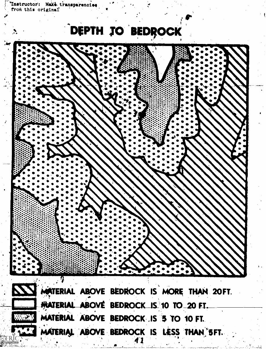
In the back Z2f your Study.Guide is anAnvelope containing three maps and oneblank transparency. The three maps areIl) a simplified slope map, (2) a depth
,to bedrock maOrand (3) a drainage map.
Using the blank trawarency and wax.pencil, CONSTRUCTA SUITABILITY MAPshowing the areas that satisfy the Ooye thi.ee'qualifIcations. Place thetransparency on each of.the three maps individualltiand mark thp areas,that are not suitable. You can then identify the areas that are suitablefor constrilction of the residences for Tony Odoms real estate project.
4
orJ101111140° INSTRUCTIONS: J
5, When you have completed.the above activity,.restart theaudio cassette tape'and 1.01ew the ,remaiaing slides,in this.lesson.
;61
4.
1.
A
'ArlswiRs yo 41143CTIONS IN STUDY GUIDEtft
:ACTIVITY 41 Anfwers "
,4- Given data concerning Buda Formation and Del Rib Clay
.:\ P. Wh uld At be easier to cdnstruct:undergpound utiiiiies?
,ipa imeseoneDe o Clay . . X4 -
7-
Why?
_It wbUld be easiet' to construct'underground utilities-on Del Rio.
Clay. As you 6dn tel from the "eXcavation characteristic$" columnof the descripttiob of t e rock unitsi-excaYation in BUda'Limestonela difficult and "giner y:req1113:es blaltin&." However,'Del Rio
. Clay on the other-hand_ialiCately easy.to elwavate-with lightmachinery9
2.3 YOu haye the .choice 9f two bufiding sites on which to Wild a home.Or4 is on Buda Limestone, the:other-on Del Rio elay.'-Both arerelatiVely flat topography.i.',Which would you choose?
Buda Limeatone*-XDel Rio,Clay
Explain your chpfce.'V
Del RiwClay has a high shrink/swell ratio. Del Rio Clay ifs,:also
unidea?. fortjie 1n'ata1latn of septi.c tanis. This means thatunless a selecti fill of kravel and/or a specialIoundation isincluded in the construction, you Can be assured ybur hOuse.willdevelop. cracks arid will settle unevenly,/ 'Doors and windoWanot close properly. Del Rio is easier to excavate than is Buda;however, 1.t-no basement.is:Planned there I'll; probably be littledifference in excaliation costs on the two rock unitOC.
I
Assuming that the.BUda LiMestone site 4$ not at the edge.of a .
.steela.6.66pe above:Del-Rio-Clay', the,Buda Limestone site-nuld bepreferAlle. The Limestone.unit has ilone ofthe unfairorabltc,characteristics of,the Clay unit and hda a high bearing bap:way...00'
\
-.- .
. . ..',
Yott are. president Of the Aiver City Garaen'Club.whidh iv about to ,.
select a new site l'Or Os clubhouse. Yoll plan. to plarA a lut3h .
garden around ihe clubhouse-6thich'shows*hative_tfees of,your state.,
on which,-rock upit would you prefer tO'build?.
,
Buda Limestone XDel Rio Clay .
Why?r
a
at
r
e I
A-6-A
PYou will nott rtom the General Descriptions Cif the-two.formations thatBuda Limestone supports the-growth of fourligtive. trees, but'Del Rio
Clay supports only two. Thftrefore, Buda Limestone is the optimum choicefdr a garden of native trees.
.
You have found a bealitifufbuil4Mgite (x) with a gorgeous view(see figure below). A highway was just cui through thq. valley below.
it kid the oliff cleared of rubble and boulders% Would76u.feel-concident building at x?,-Why or why not?
,41;
X
42 I
,
Yes - No X
Why?
Buda Limestone,falls on steep slopes above Del Rio Clay. Therefore, X
1.s not a wise-choice for a house site-. Since Buda-Limestone,falls on.
steep slopes above Del Rio Clay, It would be unwise to'bnild on the,edge
ofthe cliff. The Del Rio Clay will begin to creep down the hill and.ltkestone above it will fall and slump down slope, thereby stabilizingthe slolie. You will then have.-the view at Y that you so badly wanted
at X.
X Y
VS
13
(3)
8
GLOSdARY
Alluvilip: a general term for seiimentts'depotited by rivers and streams.
bedrocls: any solid rock exposed at the surface of the earth or overlainby gravel, sand, clay, etc.
cartogr,apher: person who constructs a map when given all the fieldinformation about the area.to be mapped.
cartography: the science and art of map construction.
city planner: the person who supervises, participates in, and recommendssocial and economic planning fqr a particular city.
ellty a widely distributed earthy substanee, plastic when moist, composed'primarily of decomposed.igneous and metamorphic rocks ,x4ch in themineral feldspar.
effluent:. liquid discharged as i/aste (as water used in industrialprocesSes or sewage).
formation: a unit of rock which is identifiable by lithologie orstructural features.
geologic map: maps which show the location of all rock units in anarea, and identify those rock Units by color and/or Symbols.
the science which treats of the eartl, the rocks of which itis composed, and the changes which it has undergone.
geology:
-
land use planning maps: those maps whi:ch were constructed.to asaist inthe wise planning and use of land. A set of wch maps usuallyincltde data about soil, vegetation, depth to bedrock, slope, .
physical properties of soil and rocks, geology, engineeringcharacteristics, etc.
limettone: a bedded sedintary rock consieting chiefly of calcium'carbonate (CaCO
3)
reek unit: see "formation."tS
septictanks: a tank in Which the organic solid mittersof continuouslyflowing dewag; is dePolited and retained until it ha's beendisintegrated by anaerobic-bacteria.
shrini/sWell: an exp$ession which indicates an extreme Auctuation inthe volumeOf a soil, proportional.to the amount of water ithas absorli. Por eiamplei some clays wten wet expand to 13times thei dry size; they are said to have a high shrink/swell.
a
14
F-
9
shale: a rock formed by the &msolidation of din,. mud, o'r hilt,and has a finely stratified structure parallel to bedding.
P- Alutalp: a map which described slopes in percentage of rise per unitof horizontal distance (see figure). In this system ofmeasurement, a slope of 45 degrees is equal to a slope of100 percent.
111a
100 ft.
r-i
Slope of 10%
loo
suitability maps: a map which indicates where the most suitable landfor any one purpose is found. For example,,a suitabilitymap for residences with basements would show the most suitable'areas fop cOnstruction of such buildinp.
topographic map: a map that shows tbe surftce features of a region,including hills, rivers, cities, etc., generally throughthe use of special symbols and contour lines.
topogyaphy: the physical4features of a region, especially the reliefand contour of the land .
utility pipes: pines through which water, gas, or sewage flow, usually'underground.
or.
't"
C
4e.
1
. A Pilo
BIBLIOGRAPHY (
f f olf " -
a.
A 10
. StateGeological Survey of Kansas. Planning for Development"701" Project No. KANS. P-43, Report No. 15.1). June, 1968.
Flavin, Peter T. Environmental Geology: conserviktjt.ont. Land-Use Planning.,and Resource Management. New York: Harper and Row, 1970.
McHarg, Ian L. Design with Nature. Garden City, New York: NeuralHistory Press, 1969.
'A
-r34
..,
1a
SCRIPT FOR LEARNING CARREL LESSON
6.2'
LAND USE
ENVIkiONMENTAL STUDIES
ce\
A Cooperative Project of thA Departmentof Geological Sciences 'and the ScienceEducation Center
THE UNIVERSITY OF TEXAS AT AUSTIN
ck;
a
1
....1
Blank ColoredSlide
1
"LIND Uis PLANNNWMAMP Learning Carrel Lesson 6.2
2
Vfew.of theplanet Earth
About four billion people live on the surface ofthe planet Earth.
3 J.
Aerial viewof largecity(downtown
"-1'
area)
Man has been physically confined to this ribbon-of life ever since he appeared here.
Phota of TonyOdams (land 1
devldpert,-salesman)
Meet Tony Odoms, a real estate developer.
.,
Tony gesturingto hill country
1 r-
Tony has just purchased thi-\640 acres of land.
2
Panoramic shotof Tony and,.hill country
r-
He plans to build a subdivilAon of one and two-story:priyate residences with full bgsements onit.
Tony with a.worried look
But he has a problem. Which sites should hechoose.to build on? ,
Bill settingamia construc-tion with .blue-prints on hii
lop, lookiworried.
4,11
,
It worries him because his friend, Bill Cantrell,just went broke trying to,build's subdivision wherethere ws* solid,rock two 'feett under 'the weed*.
a.
1 9
Bill in frontof "Condemned"apartmentbuilding
1
--`
.Befare that, his friend-Bill built an apartmentcomplex which was flooded three weeks after itwas completed. And before that ...
10
L_
Tony diggingfrantically inhis ground witha
-1
shovel
'- r---
Well, anyway, Tony is beginning-to suspect heshould find out a little more about his landthan Bill did before he decides what he isgoing to use it for.
11 I
Irony holdingup big hunkof limestoneand scratching
head . 4_,
Tony has heard about geology, but he knowS nothing.about it himself. Where does he go to find out1.about his land?
12
LAND USE PLAN-NING MAYSLCL
.
.11MMOMM
This lesson is pout land use planning maps. Beforeyou begin, please open your Study Guide and readpages 1 and 2 and the Glossary in the back of yourStudy guide.
Stop the tape now.
k
L.Pompeii For thousands of years, ihrthquakes and volcanoesexcavation have destroyed cities
*lb
Hovever, men continuo to build on the slopes of theadtive volcanoeS,
15
Stretchervictims inCaliforniaearthquake
If*
and in zones of violent earthquakes.
16
treeserwater 1
0.
Centuries and aeons ago, floods destroydd citiesand populations.
Aerial view-. of subdivisiunderwater
t,
I
4
Yet, man still builds ar161 concentrates in areas ofheavy flooding.
.
5
18
crumplby an earth-quake
_
. 19
For a long time we have been told that the foolishman builds his house upon the sana,
House oit
stilts hang--ing over edge-of cliff
11.
yet we still haven't gotten the idea.
PhcAo of--theleaning Towerof Piso
-41
ft's not only.in great catastrophies that poor land, uspis revealed. There are other smaller, more frustratingmistakds of which could have been prevented.
22
11
lor
21
Subaviiionduring construetionk. can see
roads.cut ihtohills
1
6
,
TOU have already heard about the housing development,vhich,was begun n an area where limestone lay only'a few feet below the surface. Unaware of this,the dev,eloper had planned for basements in thehouses, and underground utilities.
22 1
Close-up of 'rocky ground
r--
As construction progressed, plans for liasements hadto be revised or abandoned; utility V.tches had to-be excavated in_rodki causing considerable expenseto residents, the.city, and the develolier.
*.
An'apartment complex was constructed near the junctureof two creeks.
S.
1
Ain carrringwoman tproughdoorway offloodeduiiding
t.
Shortly after completiont, a summer rainstorm flockedthe area, leavingstpelve to fifteen inohas of waterin the-firet,floor apartients..
,4
0 ,
City septic tanks have been built on flood plains andare releasing polluted effluent into the same gravelanewsand from which the water supply for that same cityis-pumped.' '
Rusted utilitipipes
,I.-27
Utility pipes are laid under a very corrosive foil..Tbree years later, the pipes must be dug ut andreplaced with pipes made of material which does notreact chemically with the Soil,
One man ex-plaining ageology mapto another
jand the list goes on end on. The real tragedy isthat all these mistakes could have blen voided ifthe city's builders and planners had been providedwith geological data about these sites.
28
Geologist infield
/'
11/01111
...,... .......
The persop most qualified to provide information of'this sort is the geologist who for yeah has beenportraying this information on maps.
a
24
29
Busy sidewalkin city
8°'
City and regional planning has recently assumed agreater priority as our cities have begun expanding
an explosive rate. It has been recognized thatthe basis foil' any planning venture should be knowledge.Of the land itself.
30
City Plannerbehind desk
4
(City Planner's voice) The planning departmentstaff has felt for a long time that geology isprobably one of the most important inputs to landuse decisions. Consequently, it was 'our decisionto'use the environmental geology and the geologicalderivative maps as the base for all of our planningfrom this point.
31
Another shotof City Plan-ner behind
desk
(City Planner:a voice) This means that (1) thelocation of major streets, (2) the distribution ofperformance standards for zoning applications,(3) performance standards tor building sites, and(4) the performance standards for constiuction codeswill all be based on the derivative maps preparedfront the inventory of geological information. Thiawill be the beginning point, not the end point.
I '
32
A
Four peopleooking and'liking about
ps 4
4111111111MNIP
Ttle development of land use,planning maps is a,teameffort requiring the contribution of many people.
33
Architect at 4
Work/eityPlanner behinddesk
Once'the decision hae been made.to map an area for4 the purpose of.land use planning, ths geoloesth
who will be doing the mapping mifet with'city 'planners,locii architects, and other people mho work withthe physical environment to determine what informationis needed and 'wanted on the Maps for that area.
11
34
illj,
City Plannergesturing tocity map onwall
-
(City Planner's voice) I think twb or,the worst. problems of which I am aware are first,,limestone
in the northwestern and Western parts of the citywhere it is necessary to blast for utilities andsfor streets. We have s6me very extreme slopes'west of the city as well.
e
35
,City. Planner
at desk again(City Planner's voice): The second extreme is in tgeeastern part of town there there'is a lot of clay.When it rains and dries Out, this clay tends tb movearound, making the correct design of:foundations aproblem. Again, We are also talking about streetsand utilities that warp and crack, because this, soilis so mobile.
GeolOgist mapping on fiillside abovesubdivisibn
mos
The fir stevin the project is ie construction of ,
a compr hensive and detailed geologiC map of the area..In maid geologic maps, 4.t is conventional to dhowrock un1i as if no soil cover existed.over them.,
XJ1
37je.
s
Coloredgeologicmap
"71VI"
r[eqds holding
pilling caps
A
41010
For example, all the Srellow in this matrepresentsalluvitim, blue represents-a shale, rer'representsa limestone, and'the green another limestone unit,and't6e purple another shale unit..
Engineering data is gathered from local engineeringfirMs, state-agencies, and city departments. Suchdata provide future builders and planners withinformation like ... 5
Sprinkler on,a hillside
how miich water a soil on a hillside can absorbbefore it Will slide down the hill,
fi
to
.40
TIM beakers ,# one 1/2 full
and the other.' *r
3/4 full
o11
.
Or the yet volume of a soi camPared. to its volumewhen dry. *
.4;1' 2 tt
r
Two men in Flood dipa I. obtained from federal and gtateNydrologic agencied,Office"
1
142
Geologists4alking to a
merchant
and sametimes in the field through interviewswith local citizens.
A
143
Geologists atairport, sur--
veYing
1,
10Irr
I.
durrint land use is also surveyed and mapped.
e.
. .
Geologist tiolding soil iihands by ariver
I.
morre
Other things mapped are vegetation and soils.
2 8 r
.,
Il
Chart
1
C,
12
41.
,)
Once all this and dther,data are collOted, the geologicformations in the map area are described in terms of
,
this deli. It yOu were given all thls information abouta particular rock unit -- soil and Vegetation data, geo-logic and engneering data -- would you-be a e,to makedecisions aboUt the optimum land use of thatj rock unit?
146
Do the Activityon page 3 ofrGour Study
uide
147 1
1,
ow
In your Study Guide on page 3, you will find ansktivity to do. Please stop the tape now.
. .n, ww.K.Alt,4
Geologistdrawing amap.
After all thp data has been_collected, the map-makingbegins.' Project personnel decide, usually as a group,what kinds of maps will e'published,'
148j
1
Maps beittlg
drawn
.*IIIN1111.1
4.
and then dray these maps in rough form on aerialphotographs of topographic maps.'
13
Cartographer These rough maps are then given to artographerswho draw the final publishable maps. These arepubliehed anormade available to the public and
cdrawing maps
interested perdons.
5Q
1
11
Two personslooking at mapon display
The published land use planning maps providr plannersand developers with widely available data on whichthey can base important'decisionse
4d,
city Plannerholding maps
I
(City Planner's void4 These maps are going to be usedas a part of our Masier.Plan Program. The inventoriesof soils, slopes, construction chvacteristics, anaother parameters which are being provided.will be our,base for the Master Plan. These base maps will, in
veffect, say, "Here is where development can oéCur andhere is where it should not occur for thgse reasons,both technical and non-technical."
City Plannerpointing atmap
-L
If developers then take that.information and insist ondevelopment at less than favorable sites, at leastthey have the technical background for street, home,and utility installation. They will not4be developingblind.
30
53'
Close-up of (Tony Odams' voice4.. Hi there! You remember me,.Tony with don't you? Tony Odoms, yourtfriendly real,estatecigar developer.
I
54
1.--1 1t/
Tony jumping )for joy hold-ing maps
14
(0d6ms' voice) my troubles are ovet now: Solvedall Iv problems with these lanp(use planning maps.
v
55
L-Tdny gazing athis land
5.1147
Gently sloping
. land
'15%
As you recall, Tony had just purchased this 640 acres"of land, and Wanted to build one and two-story private.residences with full basements in this area. Tony soondedided that he Was restricted to building sites withthe following characteristics:
II
4
Sites must have slopes of no more than 15% grade.
31
.3
57
Bedrock crop-,
ping out atsurface
t.
15
Bedrock on the sites should be betwean 5 and 10 feetbelow the surface, to avoid expensive'blasting andexcavation procedures.
58
Smalr creek
V.
Sites must avoid natural drainage ways.in order toprevent'flooding and dampness in basements.
59
Tony handing asecretary $20and holdinglots of maps
Tony found out from his local Zoning Commission thathis area vas included in a regional land use mappingproject. The set of land use planning maps availableincluded the following three which are of.particularinterest to him:
Drainage mapThe natural'drainage pattern map in which all dry andvet creekbeds and natural waterways are shown.
32 ,
Depth to bed-,
rook map
t
The<depth to .oldrock maps which simply indicatehow many feet 'below the surface bedkodk,lies,
62
Simplified and the slope map which shows how-steep the land is.Slope Map
k
i
6
2-
63 LPicture of map.in back ofStudy Guide
tort
In -qhe envelopeAn the.back of your Study Guide,. youwill find three maps scaled down to the 640 acresTony bought:
614
Do the. 1
Activity onpage 5 of yourStudy Guide
t,
You will now construct uitability maps with these3 maps. Please turn to page 5 An your Study Guideand road the instructions. ,Stop the tape now.
33
,
c.
17,
map for
Answer map.Suitability
residentles
with basements
This is whit your suitability map should look like.Stop the tape again and cbmpare your map with this one..
MetropolitanScene"
n
Land use planning maps can benefit everyone in acommunity. In the case we just saw, there werefever mistakes made, and everyone saved --
. 67
Happy home--owner infront ofhouse
the homeowner who paid less forjas house,
[1
Utility pipesbeing instal-led
.
07-$t17!7.,7:.
1
the city who learned from the maps,where to lay tHestreets and utilities,
34
ll
69
Happf ,
*
' 18
and the banks which weren'tjeft with abandoned,flooded homes add uRpaid mortgages.
P miat.
Ow
70
IGil.: holdlng '
up "Sold" signin front ofnew house
--
Oh yes, and our friend Tony -- he saved money too.
(Tony's voice) Do you want to uy a new 3 bedroom,2 bath, 2 car garage, all elec ric kitchen, landuse planned home?
71
End of thislesson
rror
,
3 5
t.
LESSON 6. 2 : LAND USE
STUDENT RESPONSE SHEETS
tr
a s
t.;
a
Activity #1
Name /c
Date .
LESSON 6.2: LAND USE
STUDENT RESPONSE SHEEP
Given data concerning Buda.Formation and Del Rio clay
1. Were would it be easier to construct underground utilities?(Check correct formation)
Buda LimestoneDel Rio Clay
Why?
),4
wieminis
p.
?
2. Tou have the choice of two building sites on which to build ahome. One is on Buda, L0 imestone, the other on Del Rigelay. Bothare relatively flat topography.* Which would you choose?
Buda LimestoneDel Rio Clay
Uplain your choice.
4,
e 44
3 7
s,
r
Name
Date
LESSON 6.2: LAND USE
STUDENT RESPONSE 8HEIM4-
3. You arcpresident of.the.River City.Garden Club which is about to.kelect.4 hew site for its clubhouset, You plan to'plant a lush'girden around:the clubhouse which shOws native trees of your state.011, which rdck unit would you prefer to build?
Buda LimestoneDel Rio Clay
Why?
At ..0.140.VAPP V..St7"4"..
4,v-trtle:,..44044,
! ,14 You have found a beautiful building site kx) with a gorgeous view
(see figure below). A highway was just cut through the valley belo4it,an the cliff cleared of rubble and boulders Would you feelconfi ent building at xl Why or why not?
X
ies No1111.111MOMOMell
.Whksar-,. 4'','J All144 Ate.! N44-re
.v .
4
p.
Make bisa tre.rmiarenci for map over:1.94_
rethir
. ".*
Pvir
-6"it .t
-
a41,
,
,vt-104%,411allpytegWV/01014(4-;4cVtitkeksMiy, -
tt
Vb.
a
3 9
,..
a
4
et
s';-
t;
InstructOi.: 'Make transparencielfrom this original
6'
v
DRMNAGE MAP
ga STREAMS
BIB GENERAL PATTERN OF STREAMSLAND AREA
4 o
'Instructor: Ma,ki tiansparenois4froth this originat