Page 1
TS 5B - Information Management Software
Hamed Olfat, Abbas Rajabifard and Mohsen Kalantari
Automatic Spatial Metadata Update: a New Approach
FIG Congress 2010
Facing the Challenges – Building the Capacity
Sydney, Australia, 11-16 April 2010
1/18
Automatic Spatial Metadata Update: a New Approach
Hamed OLFAT, Abbas RAJABIFARD and Mohsen KALANTARI, Australia
Key words: Spatial metadata update, Automation, Synchronisation, GML, XML
SUMMARY
Spatial metadata is a vital tool for spatial data management, retrieval and distribution. It is
also a critical component for any spatial data sharing platform which provides users with
information about the purpose, quality, actuality and accuracy of spatial datasets. With the
amount of spatial data exchanged through the web environment, the demand for automatic
spatial metadata creation and updating to describe such resources is increasing. However,
automatic spatial metadata updating is still in its infancy and automatic approaches are being
explored by researchers.
So far different processes and tools have been developed which generate and update a limited
number of spatial metadata elements in different standard schemes automatically, thus a large
amount of spatial data elements need to be imported manually. In order to improve this
situation, this paper aims at exploring a new synchronisation approach based on XML/GML
technologies to automate spatial metadata update process, by which dataset properties are read
from the dataset file and written into its metadata file automatically.
The paper first discusses the important role of metadata in Spatial Data Infrastructures (SDIs)
as an enabling platform and proposes an architecture to manage spatial metadata. It then
compares different methods of spatial metadata generation and presents a spatial metadata
automation framework. Based on this framework, the paper finally introduces a
synchronisation approach to achieve the spatial metadata automatic update.
Page 2
TS 5B - Information Management Software
Hamed Olfat, Abbas Rajabifard and Mohsen Kalantari
Automatic Spatial Metadata Update: a New Approach
FIG Congress 2010
Facing the Challenges – Building the Capacity
Sydney, Australia, 11-16 April 2010
2/18
Automatic Spatial Metadata Update: a New Approach
Hamed OLFAT, Abbas RAJABIFARD and Mohsen KALANTARI, Australia
1. INTRODUCTION
Metadata is commonly defined as "data about data" and is the key to ensuring that resources
will survive and continue to be accessible into the future (NISO, 2004). We now face an
increase of spatial datasets being created and exchanged between people or organisations. As
more data and information is produced, it becomes more vital to manage and locate such
resources (Göbel and Lutze, 1998). The role spatial metadata plays in the management and
location of these resources has been widely acknowledged (Tsou, 2002; Limbach et al., 2004).
Furthermore, spatial data can now be easily downloaded from the Internet, e.g., spatial data
catalogues (Devillers et al., 2002). With the increasing distribution of spatial data over the
Internet there is a corresponding increasing demand for spatial metadata describing the spatial
data in a networked environment.
Metadata also plays a critical role in any SDI initiatives. One of the first steps for the setting
up of an SDI is the creation of metadata standards and a corresponding metadata catalogue
(Pasca et al., 2009). These not only provide users of spatial data with information about the
purpose, quality, actuality and accuracy of spatial datasets, they also perform the vital
functions that make spatial data interoperable, that is, capable of being shared between
systems. Metadata enables both professional and non-professional spatial users to find the
most appropriate, applicable and accessible datasets for use (Rajabifard et al., 2009).
In spite of the numerous benefits of metadata, the remaining issues and obstacles to the
creation and updating of such geospatial surrogates are numerous. Spatial metadata which is
created and updated manually or semiautomatically, is considered as monotonous and time
consuming, a labour-intensive process by organisations and is commonly viewed as an
overhead and extra cost. Also, metadata for spatial datasets is often missing or incomplete and
is acquired in heterogeneous ways. Moreover, metadata is usually created and stored
separately to the actual dataset it relates to, and is often managed by persons with a limited
knowledge of its value. Separation of storage creates two independent datasets that must be
managed and updated - spatial data and metadata. These are often redundant and inconsistent.
Thus the reliability of spatial information and the extent it can be used are unclear.
To address some of these issues, particularly relevant to spatial metadata updating processes,
this paper aims at exploring a new synchronisation approach as an automated process for
updating spatial metadata, by which dataset properties are read from the dataset file and
written into its metadata file automatically. This is based on ongoing research by authors on
―Spatial Metadata Automation‖. This paper first proposes an architecture to manage spatial
metadata in the SDI context and then compares different methods of spatial metadata creation
and updating and focuses on an automation framework. This framework embraces three
Page 3
TS 5B - Information Management Software
Hamed Olfat, Abbas Rajabifard and Mohsen Kalantari
Automatic Spatial Metadata Update: a New Approach
FIG Congress 2010
Facing the Challenges – Building the Capacity
Sydney, Australia, 11-16 April 2010
3/18
streamlines of create, update and enrich. Finally, a new synchronisation approach is
introduced to address the automatic updating streamline.
2. SPATIAL METADATA MANAGEMENT ARCHITECTURE
The creation of an enabling platform such as SDI for the delivery of spatial data and tools will
allow users from diverse backgrounds to work together with current technologies to meet the
dynamic market place (Rajabifard et al., 2005). Within an SDI platform, metadata plays a key
role to facilitate accessing up-to-date and high quality spatial data and services (Williamson et
al., 2003).
Within the SDI context, developing an architecture which covers the metadata management
process from spatial metadata preparation to its publication in a networked environment is
fundamental. To achieve this purpose, an overall architecture for spatial metadata
management has been developed (figure 1).
The presented architecture includes components such as publishers, registry service, catalogue
service, metadata editor, metadata repository, applications and requesters. In this architecture,
spatial metadata publishers publish spatial metadata to web environment through web
services. Metadata records after publishing are registered in data catalogues through registry
services. The catalogue service handles the discovery and publishing of metadata entries and
harvests metadata records from other repositories. Spatial metadata repositories store
metadata records which are published. Moreover, existing metadata records stored in
repositories can be manipulated and updated through metadata editors. Lastly, different
applications such as spatial metadata discovery, viewing, and access would be available for
requesters (users and value-adders) via web services.
Publishers Publishing Spatial Metadata
Publisher 1
Publisher 2
Publisher n
W
E
B
S
E
R
V
I
C
E
S
Publishing Spatial Metadata
WEB Environment
Registry
Service
Catalogue
Service
Spatial Metadata
Repository
User
Value-Adder
Discovery
View
Access
Requesters
Applications
Metadata
Editor
W
E
B
S
E
R
V
I
C
E
S
.
.
.
Figure 1. Spatial Metadata Management Architecture
Page 4
TS 5B - Information Management Software
Hamed Olfat, Abbas Rajabifard and Mohsen Kalantari
Automatic Spatial Metadata Update: a New Approach
FIG Congress 2010
Facing the Challenges – Building the Capacity
Sydney, Australia, 11-16 April 2010
4/18
In this architecture, standardised spatial metadata is a powerful tool that enables the requesters
to discover and select the relevant spatial datasets quickly and easily. Hatala and Forth (2003)
also concluded that metadata can fulfil its purpose only when it compiles with some agreed
upon standard. A metadata standard provides a set of elements, defines their meanings, and
provides guidelines and constraints on how to fill element values. On the other hand, in order
for this architecture to be efficient and effective, it is essential that up-to-date spatial metadata
be delivered in a specified standard to the requesters. As the demand for standardised
metadata increases, spatial industry needs to identify automated metadata production methods
that are more efficient and less costly than those practices involving manual production
(Greenberg, 2004). Automatic metadata generation can be facilitated when the structure of
metadata is based on a selected standard. However, there are different standardisation
methods in metadata domains as discussed below.
2.1 Spatial metadata standards
International organisations have been working for several years in order to achieve a common
standard regarding metadata for spatial information. The most important ones are ISO 19115
(Kresse and Fadaie, 2004), FGDC (The Federal Geographic Data Committee), DIF (Directory
Interchange Format), and Dublin Core (Schindler and Diepenbroek, 2008).
In recent years, the popularity of the ISO 19115 standard which provides information about
the identification, the extent, the quality, the spatial and temporal schema, spatial reference,
and distribution of digital geographic data (Moellering et al., 2005), some organisations have
decided to adopt profiles of this standard. For instance, the Australia New Zealand Land
Information Council (ANZLIC) released an Australian/New Zealand profile of AS/NZS ISO
19115:2005, Geographic information-Metadata (implemented using ISO/TS 19139:2007,
Geographic information-Metadata-XML schema implementation) in August 2007 (ANZLIC,
2009). Also through efforts seeking for collaboration, U.S. and Canadian scientific volunteers
from the International Committee for Information Technology Standards Technical
Committee L1 (INCITS/L1) and the Canadian General Standards Board Committee on
Geomatics (CGSB-COG) developed the INCITS 453-2009, the North American Profile
(NAP) of ISO 19115: 2003, Geographic Information – Metadata, to meet the requirements of
both countries in July 2009 (FGDC, 2009). In addition, the Permanent Committee on GIS
Infrastructure for Asia & the Pacific (PCGIAP) has recently released a draft version of Asia-
Pacific Geospatial Metadata Profile based on ISO/IS 19115 core metadata elements and other
regional profiles as well as the survey results of participating countries.
The standardisation of the spatial metadata structures will bring efficiency to metadata
management by providing a common understanding of metadata elements; however the
challenge of metadata automation lies in metadata being human readable/understandable
rather than machine readable/understandable. The next section discusses metadata generation
approaches and the importance of metadata automation with emphasise on metadata being
machine interpretable.
Page 5
TS 5B - Information Management Software
Hamed Olfat, Abbas Rajabifard and Mohsen Kalantari
Automatic Spatial Metadata Update: a New Approach
FIG Congress 2010
Facing the Challenges – Building the Capacity
Sydney, Australia, 11-16 April 2010
5/18
Manual
Approach
Semi-automatic
Approach
Automatic
Approach
Figure 2. Spatial Metadata Generation Approaches
3. SPATIAL METADATA GENERATION APPROACHES
The generation of spatial metadata can be separated into automatic, semi-automatic and
manual data mining methods (Taussi, 2007) as illustrated in Figure 2. Automatic methods,
such as automatic retrieval or searching and sorting of data are based on computerisation.
Semiautomatic methods combine automatic and manual methods. Manual methods are based
on human reasoning and decision making.
These approaches have been formed and evolved based on the technological initiatives over
time and the characteristics of spatial metadata such as type and format have been influenced
by these initiatives. For instance, after the PC Era and Internet initiative the spatial metadata
were generated in Markup Languages (e.g. Hyper Text Markup Language (HTML) and
eXtensible Markup Language (XML)) since the early 1990s. Figure 3 illustrates the spatial
metadata creation approaches and different types of spatial metadata based on technological
initiatives.
Figure 3. Spatial Metadata Generation Approaches, Types & Technological Initiatives
Among these approaches, many people view manual metadata generation as monotonous and
time consuming, a labour-intensive process which is a major undertaking in itself (Guptill,
1999; West and Hess, 2002), resulting in a pervasive outlook which shuns metadata creation
(Mathys, 2004). Meanwhile, one of the main obstacles to the widespread adoption of systems
which make intensive use of metadata is the time and effort required to apply metadata to
multiple resources and the inconsistencies and idiosyncrasies in interpretation that arise when
this is a purely human activity (Hatala and Forth, 2003). Moreover, it is commonly viewed by
organisations as an overhead and extra cost. Finally, metadata for spatial datasets is often
missing or incomplete and is acquired in heterogeneous ways (Rajabifard et al., 2009).
Metadata
Types
Manual Semiautomatic Automatic Metadata
Generation
Approaches
Paper Map legends
Digital Map legends,
Text files, pdf
HTML, XHTML, XML,
RDF, …
PC Era
Internet and World Wide Web
Social and Semantic
Web
Technological
Initiatives
Page 6
TS 5B - Information Management Software
Hamed Olfat, Abbas Rajabifard and Mohsen Kalantari
Automatic Spatial Metadata Update: a New Approach
FIG Congress 2010
Facing the Challenges – Building the Capacity
Sydney, Australia, 11-16 April 2010
6/18
The use of automatic processing can, in turn, permit human resources to be directed to more
intellectually challenging metadata creation and evaluation tasks. These factors underlie
automatic metadata generation research efforts and the desire to build superior and robust
automatic metadata generation applications (Greenberg et al., 2005). More importantly, the
ability to automatically generate metadata relating to spatial data, and make it available
through SDI will have important benefits to all practitioners including spatial data producers,
vendors, distributors and users. Many organisations are also looking at automated metadata
systems to reap automatic metadata generation benefits. This is evidenced by the large
number of projects and companies who are creating programs which automate metadata
(Baird and Jorum Team, 2006). In the next section a framework for spatial metadata
automation is introduced.
3.1 Spatial metadata automation framework
The idea of automatic spatial metadata generation research is rooted in automatic indexing,
abstracting, and classification of spatial data content, which began with the need to organise
increasing amount of spatial related data and inability of human-authored methods to cope
with huge amount of spatial metadata (Rajabifard et al., 2009). Today, automatic metadata
generation should move beyond subject representation to encompass the production of author,
title, date, format, spatial extension and many other types of metadata. In addition, thousands
of spatial databases are now networked via the Internet, and information resources are
frequently rendered in open and interoperable standards (e.g. XML). These developments
should enable automatic metadata generation systems to work on far larger spatial data
directories.
Although automated metadata generation is still in its infancy and there is no conceptual
framework to define, several approaches have emerged, including metatag harvesting, content
extraction, automatic indexing or classification, text and data mining, social tagging, and the
generation of metadata from associated contextual information or related resources
(Polfreman and Rajbhandari, 2008). A framework for automating spatial metadata which is
based on three main streamlines including automatic creation, enrichment and updating, has
been introduced by (Kalantari et al., 2009) as illustrated in figure 4.
Figure 4. Spatial Metadata Automation Framework
Automatic Creation: When there is no existing metadata associated with spatial data, there is
a need for exploring methods to create spatial metadata. Humans create metadata by writing
descriptions of resources either in a structured or unstructured form. Computer applications
Spatial
Metadata
Automation
Create
Enrich Update
Page 7
TS 5B - Information Management Software
Hamed Olfat, Abbas Rajabifard and Mohsen Kalantari
Automatic Spatial Metadata Update: a New Approach
FIG Congress 2010
Facing the Challenges – Building the Capacity
Sydney, Australia, 11-16 April 2010
7/18
can extract certain information from a resource or its context. Several automatic metadata
extraction methods have been studied, e.g. hand-coded rule-based parsers and machine
learning (Han et al., 2003). For highly structured tasks rule-based methods are easy to
implement. The resulting rule system is usually domain-specific and cannot be easily
translated for use in other domains. Machine learning, on the other hand, is more robust and
efficient (Han et al., 2003). Several learning models are available. Among the most popular
are the Naïve Bayes model (NB), the Hidden Markov Model (HMM), Support Vector
Machines and Expectation Maximization. Supervised machine learning (SML) algorithms
include training data and machine self-correction based on errors in machine performance
against the training set (Greenberg et al., 2006).
Manso et al. (2009) also discussed how to automatically produce metadata items compliant
with ISO 19115 standard to support dynamic interoperability by extracting the information
stored in files and databases through computations or by inference. As a result, they stated
that of the 151 metadata items providing dynamic interoperability, 54 of them (including
raster data, Digital Terrain Model (DTM) and vector data) may be automatically produced
(35%). They also concluded that although this value is quite high, it should be cautiously
interpreted since it is a ―hopeful‖ value representing the ceiling of the automatic production.
Automatic enrichment: Automatic enrichment involves improving the content of metadata
through monitoring tags that are used by users for finding datasets. A tag is a non-hierarchical
keyword or term assigned to a piece of information (such as an internet bookmark, digital
image, or computer file). Tagging was popularised by websites associated with Web 2.0 and
is an important feature of many Web 2.0 services (Mika, 2005). This kind of spatial metadata
can help in describing an item and allowing it to be retrieved by browsing or searching.
Spatial tags will be chosen informally and personally by the spatial data creator or by its
users, depending on their use. On a spatial data directory if many users are allowed to tag
many spatial data, this collection of tags can become a spatial folksonomy a method that can
collaboratively create and manage metadata to annotate and categorize spatial data (Kalantari
et al., 2009).
Automatic updating: Automatic spatial metadata updating or synchronisation is a process by
which properties of a spatial dataset are read from the dataset and written into its spatial
metadata. This automatic function will support the spatial metadata to be updated at the same
time with its related spatial data update process. Therefore, it will benefit the organisations
associated with spatial metadata to save time and effort and will also reduce the risk of
inconsistency and redundancy in the spatial data and metadata. Following the predictable
advantages of automatic updating, it has increasingly been investigated by researchers.
However, the automatic update implementation still faces some obstacles and restrictions
which are discussed in the next section.
4. AUTOMATIC SPATIAL METADATA UPDATE – CURRENT METHODS AND
CHALLENGES
Automatic updating is one of the main streamlines of the automation framework which is
regarded with some obstructions. The structure of spatial data and metadata data models is an
Page 8
TS 5B - Information Management Software
Hamed Olfat, Abbas Rajabifard and Mohsen Kalantari
Automatic Spatial Metadata Update: a New Approach
FIG Congress 2010
Facing the Challenges – Building the Capacity
Sydney, Australia, 11-16 April 2010
8/18
important part of these limitations. Whereas, dataset creation and editing are detached from
metadata creation and editing procedures, necessitating diligent updating practices involving
at a minimum two separate applications (Batcheller, 2008). Rajabifard et al. (2009) also state
that separation of storage creates two independent datasets that must be managed and updated
- spatial data and metadata. These are often redundant and inconsistent. Thus the reliability of
spatial information and the extent to which it can be used are unclear. They also continued by
discussing the significance of an integrated data model for handling spatial metadata by
combining spatial data and metadata in a seamless approach. The research in metadata
integration should focus on utilising metadata standards and developments in order to
combine metadata and spatial data within an integrated package so that the process of
updating or creating spatial data and metadata – where feasible – becomes one process rather
than two.
However, some elements of metadata obviously cannot be automatically updated. These
would not be stored in an integrated fashion with the spatial data. Only those metadata
elements that can be automatically updated would be integrated with the spatial data. This will
save producers of data both time and money associated with the updating of metadata records,
and will also aid data users who require up-to-date metadata to be delivered with data for their
use (Rajabifard et al., 2009).
As a result of this, automatic update should provide a synchronised process through which the
spatial data and metadata can be updated simultaneously. In other words, this synchronisation
process not only should complete as much of the metadata elements as possible automatically
but also it should make sure that the metadata is kept up-to-date with changes to the dataset.
ESRI Company through ArcCatalog application has developed some algorithms to
synchronise the metadata content when values in the spatial data change. For instance, when a
change occurs with a spatial data property such as its projection, the metadata will be updated
with the new information. ArcCatalog automatically creates metadata for datasets stored in
the geo database if none exist. Some of the automatically generated metadata describe the
dataset’s current properties, i.e coordinate system, entity, and attribute information. Every
time the metadata librarian views the metadata, ArcCatalog automatically updates or
synchronises dataset properties with its most current values. Of course, the synchronisation
ensures that the metadata is perpetually up-to-date according to the changes in the dataset
(Westbrooks, 2004).
The process of synchronisation is accomplished using metadata standard specific
synchronisers. For example, three synchronisers are provided with ArcCatalog: an FGDC
synchroniser, an ISO synchroniser, and a Geography Network synchroniser. Figure 5
illustrates the mechanics of synchronisation process in ArcCatalog.
Page 9
TS 5B - Information Management Software
Hamed Olfat, Abbas Rajabifard and Mohsen Kalantari
Automatic Spatial Metadata Update: a New Approach
FIG Congress 2010
Facing the Challenges – Building the Capacity
Sydney, Australia, 11-16 April 2010
9/18
Figure 5. Mechanics of the Synchronisation Process in ArcCatalog (ESRI, 2002)
Although automatic synchronisation is invaluable, it brings forth numerous problems
associated with archiving and bibliographic control (Westbrooks, 2004). Making distinctions
between metadata versions, editions, and updates is crucial for any type of digital library with
archiving responsibilities. The inability of the synchroniser to differentiate a version of a
metadata record from an edition or update introduces a new set of challenges.
In addition, the current synchronisation process generates and updates a limited number of
spatial metadata elements in different standard schemas automatically and a large amount of
spatial data elements should be imported manually. In other words, the current
synchronisation process is undertaken semiautomatically.
Moreover, spatial data are usually created and stored by organisations in different formats
(e.g. Shp, Dwg, Dxf, Coverage, Dgn, etc.) which make the synchronisation process complex.
In fact, complicated algorithms should be provided to support the synchronisation process to
update the spatial metadata associated with these diverse spatial datasets.
As a result, in order to implement the synchronisation process especially in terms of
automating this process as much as possible and also supporting different spatial dataset
formats, a new approach has been proposed in the next section.
5. AUTOMATIC SPATIAL METADATA UPDATING - A NEW APPROACH
Following the requirements for automatic updating or synchronisation implementation, a new
approach based on Geography Markup Language (GML) is under development. In fact, using
GML as a common standard for which various datasets can be translated to would benefit the
Page 10
TS 5B - Information Management Software
Hamed Olfat, Abbas Rajabifard and Mohsen Kalantari
Automatic Spatial Metadata Update: a New Approach
FIG Congress 2010
Facing the Challenges – Building the Capacity
Sydney, Australia, 11-16 April 2010
10/18
synchronisation process in terms of using less-complicated algorithms and also saving time,
resources and efforts.
GML is rapidly emerging as a world standard for the encoding, transport and storage of all
forms of geographic information (Lake, 2005). GML is an XML grammar for expressing
geographical features and serves as a modelling language for geographic systems as well as
an open interchange format for geographic transactions on the Internet. Indeed the OGC
(Open Geospatial Consortium) has proposed GML specifications that take advantage of XML
to apply to geographic information sharing. Batcheller et al. (2009) also state that the
appearance of GML has helped alleviate many of the concerns relating to data compatibility
and interoperability, providing an open dialect for data transfer not bound to specific software
offerings.
Whereas GML is a Markup Language, it means that GML document has to follow certain
rules in order to be a valid GML document. This set of rules is defined in a schema document.
The documents should conform to the requirements in the GML specification. GML version
1.0 uses the Document Type Descriptors (DTDs) for defining the structure, the elements and
the associated attributes for a feature. GML version 2.0 and 3.0 use XML schema instead of
DTD. GML application schema is also an extension of XML Schema and provides a set of
type definitions and element declarations that can be used to check the validity of well-formed
GML documents (Paul and Ghosh, 2008).
GML provides several objects for describing geography, including features, coordinate
reference systems, geometry, topology, time, units of measure, and generalized values.
Applications can extend or restrict these GML objects to fit their requirements (Huang et al.,
2009).
Although GML does not provide an information model for metadata, instead a mechanism to
include or reference metadata is provided for all object elements. Indeed, GML provides a
framework by which arbitrary user-defined metadata can be attached to any GML object and
be distinguished from the defining properties of the object. This is supported through the
metadata property which can be optionally attached to anything derived from
gml:AbstractGMLType. This metadata property points to or contains a Metadata package of
properties that are the metadata for the object in question. The content of the Metadata
package is defined by a metadata application schema (a property list), similar in structure to a
GML application schema for features (Lake, 2005). For example, if metadata following the
conceptual model of ISO 19115 is to be encoded in a GML document, the corresponding
Implementation Specification specified in ISO/TS 19139 shall be used to encode the metadata
information (OGC, 2007).
Moreover, once comparing the official GML core schemas by OGC 2007 (e.g. features,
geometric primitives, coordinate reference systems, topology, temporal information and
dynamic features, units, etc) and ISO 19115, Geographic information- metadata schemas (ISO
2003) such as identification, constraints, data quality, maintenance, spatial representation,
content, etc, it has resulted that there are a number of common elements between these two
standards which could be mapped from the GML document to the metadata file. The
Page 11
TS 5B - Information Management Software
Hamed Olfat, Abbas Rajabifard and Mohsen Kalantari
Automatic Spatial Metadata Update: a New Approach
FIG Congress 2010
Facing the Challenges – Building the Capacity
Sydney, Australia, 11-16 April 2010
11/18
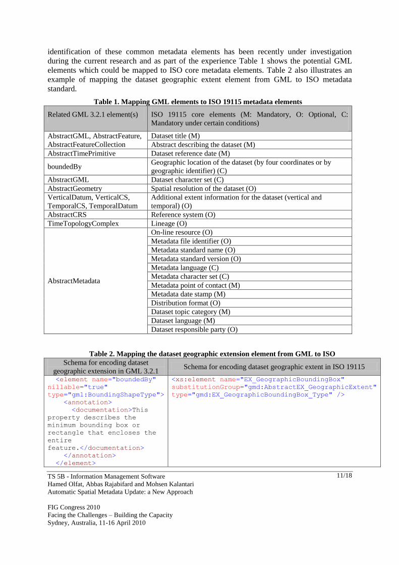
identification of these common metadata elements has been recently under investigation
during the current research and as part of the experience Table 1 shows the potential GML
elements which could be mapped to ISO core metadata elements. Table 2 also illustrates an
example of mapping the dataset geographic extent element from GML to ISO metadata
standard.
Table 1. Mapping GML elements to ISO 19115 metadata elements
Related GML 3.2.1 element(s) ISO 19115 core elements (M: Mandatory, O: Optional, C:
Mandatory under certain conditions)
AbstractGML, AbstractFeature,
AbstractFeatureCollection
Dataset title (M)
Abstract describing the dataset (M)
AbstractTimePrimitive Dataset reference date (M)
boundedBy Geographic location of the dataset (by four coordinates or by
geographic identifier) (C)
AbstractGML Dataset character set (C)
AbstractGeometry Spatial resolution of the dataset (O)
VerticalDatum, VerticalCS,
TemporalCS, TemporalDatum
Additional extent information for the dataset (vertical and
temporal) (O)
AbstractCRS Reference system (O)
TimeTopologyComplex Lineage (O)
AbstractMetadata
On-line resource (O)
Metadata file identifier (O)
Metadata standard name (O)
Metadata standard version (O)
Metadata language (C)
Metadata character set (C)
Metadata point of contact (M)
Metadata date stamp (M)
Distribution format (O)
Dataset topic category (M)
Dataset language (M)
Dataset responsible party (O)
Table 2. Mapping the dataset geographic extension element from GML to ISO
Schema for encoding dataset
geographic extension in GML 3.2.1 Schema for encoding dataset geographic extent in ISO 19115
<element name="boundedBy"
nillable="true"
type="gml:BoundingShapeType">
<annotation>
<documentation>This
property describes the
minimum bounding box or
rectangle that encloses the
entire
feature.</documentation>
</annotation>
</element>
<xs:element name="EX_GeographicBoundingBox"
substitutionGroup="gmd:AbstractEX_GeographicExtent"
type="gmd:EX_GeographicBoundingBox_Type" />
Page 12
TS 5B - Information Management Software
Hamed Olfat, Abbas Rajabifard and Mohsen Kalantari
Automatic Spatial Metadata Update: a New Approach
FIG Congress 2010
Facing the Challenges – Building the Capacity
Sydney, Australia, 11-16 April 2010
12/18
Following the discussed relation of GML standard and metadata elements, the new
synchronisation approach is based on XML/GML technologies (figure 6).
Figure 6. A new approach to automatic spatial metadata update
In this new approach, metadata publishers continue creating or updating spatial datasets in
required formats (e.g. shape files, CAD files, etc.).Then each dataset is transformed to GML
after creation or updating through a transformation method. To implement this transformation,
proper GML application schema should be designed to encode the maximum range of
metadata elements in the schema. Through the transformation, an instance document to
contain the actual data and a GML schema to describe the document would be provided.
In order to seamlessly translate, transform, integrate and distribute various spatial data in
hundreds of formats (e.g. GML, GIS and CAD formats, raster formats, etc.), some software
vendors have developed appropriate solutions. For instance, Safe Software's FME (Feature
Manipulation Engine) is a spatial ETL (Extract, Transform and Load) platform that helps the
publishers easily solve the complete spectrum of data interoperability challenges, including
managing proprietary and evolving data formats, adapting to new schemas and lack of
standards and difficulties accessing, restructuring, integrating and distributing data (Safe
Software, 2009).
Therefore, after the creation of dataset in the GML format, the synchronisation process would
start. Through this process, spatial metadata elements which are encoded in GML document
would be identified based on a specific standard (e.g. ISO 19115) and extracted via an
automatic extraction method and finally written into an XML document (based on XML
application schema, e.g. ISO 19139) automatically. In fact, the synchronisation process output
is metadata related to spatial dataset in XML format. Whenever a spatial dataset in GML
format is updated, the synchroniser would be triggered and the spatial metadata would be
updated in XML automatically; that is, spatial metadata will be updated automatically with
any change in spatial dataset.
GML Metadata in
XML
Transformation
Automatic Extraction
Metadata
Publisher
Create/ Update
Spatial
Datasets
Synchronisation Process
Update
Dwg Dxf Dgn Shp ….
Page 13
TS 5B - Information Management Software
Hamed Olfat, Abbas Rajabifard and Mohsen Kalantari
Automatic Spatial Metadata Update: a New Approach
FIG Congress 2010
Facing the Challenges – Building the Capacity
Sydney, Australia, 11-16 April 2010
13/18
The most important consideration in this approach is that most applications so far make use of
only a subset of GML core schemas as per the requirement of the domain (Paul and Ghosh,
2008).
In order to better conceptualise the process of mapping the metadata elements from GML to
ISO, a dataset (titled ―town‖) in ESRI shape file format has been transformed to GML by
FME Universal Translator. As a result of this, the output GML document has been generated
as shown in figure7.
Figure 7. GML document of “town” dataset
Based on this document, and comparing the geographic elements encoded in that and the core
metadata elements suggested by ISO 19115, the following elements could be extracted as
metadata elements and mapped to the metadata XML file as tagged in figure 7:
- Dataset title: by <fme:town>
- Geographic location of the dataset: by <gml:boundedBy>
- Dataset content: by <gml:featureMember>
The number of identified metadata elements is dependant to the transformer application as
well as the GML application schema applied by the transformer. Thus, the new
synchronisation approach under development in this research aims to expand the number of
metadata elements which could be extracted through GML documents.
This new approach to updating spatial metadata automatically will benefit the spatial data and
metadata publishers in different aspects. Firstly, it encourages the publishers to create spatial
datasets in an international open standard which will help simplify the interoperability issues
relevant to spatial data transfer and storage through the web environment. Secondly, this
Geographic location of
the dataset
Dataset content
Dataset title
Page 14
TS 5B - Information Management Software
Hamed Olfat, Abbas Rajabifard and Mohsen Kalantari
Automatic Spatial Metadata Update: a New Approach
FIG Congress 2010
Facing the Challenges – Building the Capacity
Sydney, Australia, 11-16 April 2010
14/18
approach will assist the publishers to update the spatial data and metadata simultaneously,
thus saving more time, resources and energy through reducing the number of updating
processes. Additionally, the approach based on GML as an open and neutral framework for
spatial data will decrease the publishers’ concerns on spatial data creation and update methods
and output formats. Moreover, a large number of spatial metadata elements could be updated
automatically through the new approach. Furthermore, less-complicated synchronisation
algorithms are required in this approach. Finally, this new process will minimize the risk of
spatial data and metadata inconsistency and redundancy.
6. CONCLUSION AND FUTURE DIRECTIONS
Spatial metadata can be created and updated through manual, semiautomatic and automatic
approaches. The two first approaches are considered as monotonous, time consuming, and
labour-intensive processes by organisations and they are commonly viewed as an overhead
and extra cost. Moreover, metadata for spatial datasets is often missing or incomplete and is
acquired in heterogeneous ways. Therefore, automatic metadata creation and update is being
explored by researchers due to important efficiency, cost, and consistency advantages over
manual and semiautomatic processes.
Along these lines a spatial metadata automation framework has been considered which
includes automatic creation, enrichment and update. In this framework, automatic update or
synchronisation is a process by which spatial metadata elements are read from dataset and
written into its spatial metadata file automatically. However, automatic update currently faces
some restrictions. The structure of spatial data and metadata storage in a separate fashion and
also variety of spatial dataset formats which should be considered in synchronisation process
could be regarded as some of these limits.
Therefore, a new synchronisation approach based on GML as an international standard for
geographic data encoding, transfer and storage is proposed to address the automatic update
current restrictions. Thus, the spatial data should be transformed to GML via a transformation
method before the synchronisation process begins. The output content of GML document also
depends on the transformer application design as well as the application schema that is used.
Through the synchronisation process which is independent of spatial dataset formats, spatial
metadata elements are extracted from GML document and written into XML metadata file.
Consequently, spatial metadata could be updated at the same time with spatial data update
process. In addition, this proposed approach not only saves time, resources and efforts spent
by data publishers to update spatial metadata, but also increases the number of spatial
metadata elements which can be updated automatically.
Following the new synchronisation process based on extracting spatial metadata elements
from GML document, investigating the relation between GML standard encoding
specifications and ISO 19115 metadata elements is proposed as the future research direction
for improving automatic metadata update process.
ACKNOWLEDGEMENTS
Page 15
TS 5B - Information Management Software
Hamed Olfat, Abbas Rajabifard and Mohsen Kalantari
Automatic Spatial Metadata Update: a New Approach
FIG Congress 2010
Facing the Challenges – Building the Capacity
Sydney, Australia, 11-16 April 2010
15/18
This paper is part of an ongoing research project titled ―Spatial Metadata Automation Project‖
and is supported by Australian Research Council (ARC) - linkage program. The research is
also supported by industry partners; Department of Sustainability and Environment and
Department of Primary Industries - Victoria, Department of Lands - New South Wales,
AusSoft, CubeWerx and Logica. The Authors acknowledge the support of the members of the
Centre for Spatial Data Infrastructures and Land Administration, at the Department of
Geomatics, University of Melbourne in the preparation of this paper and associated research;
however, the views expressed in this paper are those of the authors and not the views of these
groups.
REFERENCES
ANZLIC (2009). Spatial metadata, ANZLIC website,
http://www.anzlic.org.au/infrastructure_metadata.html (accessed 3 July 2009)
Baird, K., and Jorum Team (2006). Final report for automated metadata, A review of existing
and potential metadata automation within Jorum and an overview of other automation
systems.
Batcheller, J.K. (2008). Automating geospatial metadata generation—An integrated data
management and documentation approach, Computers & Geosciences 2008 - ELSEVIER
, pp.387–398
Batcheller, J.K., Gittings, B.M., Dunfey, R.I. (2009), A Method for Automating Geospatial
Dataset Metadata, Future Internet 2009, Volume 1, pp. 28-46
Devillers, R., Gervais, M., Bédard, Y., Jeansoulin, R. (2002). Spatial Data Quality: From
Metadata to Quality Indicators and Contextual End-User Manual, Proceedings of
OEEPEISPRS Joint Workshop on Spatial Data Quality, 20–21 March, Istanbul, Turkey.
ESRI (2002). Creating a custom metadata synchroniser, An ESRI White paper, July 2002,
http://www.esri.com/library/whitepapers/pdfs/metadata.pdf
FGDC (2009). North American Profile, FGDC website, http://www.fgdc.gov/nap/metadata
(accessed 10 August 2009)
Göbel, S., Lutze, K. (1998). Development of meta databases for geospatial data in the WWW,
In: Proceedings of the Sixth ACM International Symposium on Advances in Geographic
Information Systems 1998, ACM, Washington DC, USA, pp. 94–99.
Greenberg, J. (2004). Metadata Extraction and Harvesting, Journal of Internet Cataloging,
Volume6, Number4, pp.59 - 82
Greenberg, J., Spurgin, K., Crystal, A. (2005). Final report for the AMEGA (Automatic
Metadata Generation Applications) project. Technical,
http://www.loc.gov/catdir/bibcontrol/lc_amega_final_report.pdf
Greenberg, J., Spurgin, K., Crystal, A. (2006). Functionalities for Automatic-Metadata
Generation Applications: A Survey of Metadata Experts’ Opinions. International Journal
of Metadata, Semantics and Ontologies. Vol. 1, No. 1, 2006.
Guptill, S. C. (1999). Metadata and data catalogues In Geographical Information Systems,
Vol. Management Issues and Applications (Eds, Longley, P. A., Goodchild, M. F.,
Maguire, D. J. and Rhind, D. W.) John Wiley & Sons, Inc., pp. 677-692.
Han, H., Giles, C. L., Manavoglu, E., Zha, H., Zhang, Z., Fox, E. A. (2003) Automatic
Document Metadata Extraction using Support Vector Machines. In Proceedings of the
3rd ACM/IEEE-CS Joint Conference on Digital Libraries, 37-48
Page 16
TS 5B - Information Management Software
Hamed Olfat, Abbas Rajabifard and Mohsen Kalantari
Automatic Spatial Metadata Update: a New Approach
FIG Congress 2010
Facing the Challenges – Building the Capacity
Sydney, Australia, 11-16 April 2010
16/18
Hatala, M., Forth, S. (2003). A comprehensive system for computer-aided metadata
generation. In: Proceedings of 12th International Conference of The World Wide Web
Consortium (WWW2003), Budapest, May 20-24, 2003.
Huang, C.H., Chuang, T.R., Deng, D.P., Lee, H.M. (2009). Building GML-native web-based
geographic information systems, Computers and Geosciences, 2009 – Elsevier, pp. 1802–
1816.
ISO (2003). Geographic Information - Metadata (ISO 19115:2003)
Kalantari, M., Rajabifard, A., Olfat, H. (2009). Spatial Metadata Automation: a New
Approach, SSC2009, Adelaide, Australia.
Kresse, W., Fadaie, K. (2004). ISO Standards for Geographic Information. Springer,
Heidelberg.
Lake, R. (2005). The application of geography markup language (GML) to the geological
sciences. Computers and Geosciences 2005, 31, pp. 1081-1094.
Limbach, T., Krawczyk, A., Surowiec, G. (2004). Metadata lifecycle management with GIS
context. In: Proceedings of the 10th EC GI & GIS Workshop, ESDI State of the Art,
Warsaw, Poland.
Manso, M., Wachowicz, M., Bernabé-Poveda, M. (2009). Automatic Metadata Creation for
Supporting Interoperability Levels of Spatial Data Infrastructures refereed volume of the
GSDI-11 Conference, June, 2009, Rotterdam, The Netherlands.
Mathys, T. (2004). The Go-Geo! Portal metadata initiatives. In: Proceedings of the
Geographical Information Science Research UK 12th Annual Conference, University of
East Anglia, Norwich, UK, pp. 148–154.
Mika, P.(2005). Ontologies Are Us: A Unified Model of Social Networks and Semantics.
International Semantic Web Conference 2005. pp. 522-536
Moellering, H., Aalders H.J., Crane A. (2005). World Spatial Metadata Standards, Elsevier.
NISO (2004). Understanding Metadata. National Information Standards Organisation, USA.
OGC (2007). OpenGIS® Geography Markup Language (GML) Encoding Standard, Open
Geospatial Consortium, http://portal.opengeospatial.org/files/?artifact_id=20509
Pasca, M., Petriglia, L., Mattioni, F., Torchio, M., Mariotti, C. (2009). Experiences in the
Creation and Updating of INSPIRE Compliant Metadata Catalogue, GSDI-11
Conference, June, 2009, Rotterdom, The Netherlands
Paul, M., Ghosh, S.K. (2008), Application Schema Mapping based on Ontology: An
Approach for Geospatial Data Storage, Journal of Digital Information Management, Vol
6, Number 1, pp. 51-60
Polfreman, M., Rajbhandari, S. (2008). Meta Tools-Investigating Metadata Generation tools,
JISC Final report
Rajabifard, A., Binns, A., Williamson I. (2005). Development of a Virtual Australia Utilizing
an SDI Enabled Platform, Proceedings of FIG Working Week/GSDI-8, Cairo, Egypt.
Rajabifard, A., Kalantari, M., Binns, A. (2009). SDI and Metadata Entry and Updating Tools
in SDI Convergence, ed. B.van Leonen, J W J Besemer, J.A. Zevenbergen, Netherlands
Geodetic Commission, Delft, pp.121-138.
Safe Software (2009). FME platform overview, Safe software website,
http://www.safe.com/technology/FMEplatform/overview.php (accessed 13 September
2009)
Page 17
TS 5B - Information Management Software
Hamed Olfat, Abbas Rajabifard and Mohsen Kalantari
Automatic Spatial Metadata Update: a New Approach
FIG Congress 2010
Facing the Challenges – Building the Capacity
Sydney, Australia, 11-16 April 2010
17/18
Schindler, U., Diepenbroek, M. (2008). Generic XML-based Framework for Metadata Portals.
Computers & Geosciences Submitted.
Taussi, M. (2007). Automatic production of metadata out of geographic datasets, master
thesis, Department of Surveying, Helsinki University of Technology, May 2007.
Tsou, M.H. (2002). An operational metadata framework for searching, indexing, and
retrieving distributed geographic information services on the Internet. In: M. Egenhofer
and D. Mark, Editors, Lecture Notes in Computer Science vol. 2478, Springer, Berlin
(2002), pp. 313–332.
Westbrooks, E.L. (2004). Distributing and synchronising heterogeneous metadata in
geospatial information repositories for access, in Hillmann, D. and Westbrooks, E.L.
(Eds), Metadata in Practice, APA, Chicago, IL.
West Jr., L.A., Hess, T.J. (2002). Metadata as a knowledge management tool: Supporting
intelligent agent and end user access to spatial data (2002) Decision Support
Systems, 32 (3), pp. 247-264.
Williamson, I., Rajabifard A., Feeney M.E. (Eds.) (2003). Developing Spatial Data
Infrastructures: from Concept to Reality, London, UK: Taylor & Francis
BIOGRAPHICAL NOTES
Hamed Olfat commenced his PhD on spatial metadata automation as an ARC linkage project
in 2009 at the Centre for SDIs and Land Administration at the Department of Geomatics, the
University of Melbourne. The aim of this project is to investigate automation of spatial
metadata creation, update and enrichment. Hamed also holds a bachelor degree in surveying
engineering and master degree in urban and regional planning.
Abbas Rajabifard is an Associate Professor and Director of the Centre for SDIs and Land
Administration at the Department of Geomatics, the University of Melbourne. He is President
of the GSDI Association, Vice Chair of Working Group 3 of the United Nations supported
Permanent Committee on GIS Infrastructure for Asia and the Pacific (PCGIAP), a member of
ICA-Spatial Data Standard Commission, and a member of Victorian Spatial Council.
Mohsen Kalantari is a Research Fellow at the Centre for SDIs and Land Administration at
the Department of Geomatics, the University of Melbourne working on spatial metadata
automation. He was previously involved in the CRC project for the assessment of metadata
entry tools and their fitness for ANZLIC requirements. Mohsen currently is also the ePlan
project coordinator at Land Victoria, Department of suitability and Environment and is a
member of the ICSM ePlan working group. He finished his PhD from the University of
Melbourne in 2008. Mohsen has a bachelor degree in surveying engineering and master
degree in GIS engineering.
Page 18
TS 5B - Information Management Software
Hamed Olfat, Abbas Rajabifard and Mohsen Kalantari
Automatic Spatial Metadata Update: a New Approach
FIG Congress 2010
Facing the Challenges – Building the Capacity
Sydney, Australia, 11-16 April 2010
18/18
CONTACTS
Hamed Olfat
Centre for SDIs and Land Administration
Department of Geomatics, The University of Melbourne, Victoria 3010, Australia
Tel. +61 3 8344 6771
Fax + 61 3 9347 2916
Email: [email protected]
Web site: http://www.csdila.unimelb.edu.au/people/rteam/hamed.html
Assoc/Prof Abbas Rajabifard
Centre for SDIs and Land Administration
Department of Geomatics, The University of Melbourne, Victoria 3010, Australia
Tel. +61 3 8344 0234
Fax + 61 3 9347 2916
Email: [email protected]
Web site: http://www.csdila.unimelb.edu.au/people/rteam/abbas.html
Dr. Mohsen Kalantari
Centre for SDIs and Land Administration
Department of Geomatics, The University of Melbourne, Victoria 3010, Australia
Tel. +61 3 8344 3427
Fax + 61 3 9347 2916
Email: [email protected]
Web site: http://www.csdila.unimelb.edu.au/people/rteam/mohsen.html


![[PPT]Oregon Spatial Data Library – Metadata Upload Trainingoe.oregonexplorer.info/ExternalContent/OSDL/OSDL... · Web viewPreparing Metadata- Content Type For Downloadable Data,](https://static.documents.pub/doc/80x56/5b4cc0ce7f8b9a0d2d8b4b82/pptoregon-spatial-data-library-metadata-upload-web-viewpreparing-metadata-.jpg)
