Page 1
1
FitzRoy Road, Exeter, Devon, EX1 3PB United Kingdom [email protected] www.metoffice.gov.uk/services/transport/aviation/regulated
Aviation Briefing Service Portal
Table of Contents
1. Introduction ............................................................................................................ 3
2. The Home page & basic functionality ................................................................. 4
2.1. Settings .................................................................................................................................. 4
2.2. Messages .............................................................................................................................. 5
2.3. Logout .................................................................................................................................... 5
2.4. Top level functions ............................................................................................................... 5
2.5. Quick Link shortcuts ............................................................................................................. 9
2.6. Additional Information .......................................................................................................... 9
3. Aviation Briefing Products ................................................................................. 10
3.1. TAF & METAR lists ............................................................................................................ 10
3.2. Regional Forecasts ............................................................................................................ 14
3.3. Briefing charts ..................................................................................................................... 26
3.4. Balloonists forecasts .......................................................................................................... 34
4. Map weather layers ............................................................................................. 38
4.1. Basic Functionality ............................................................................................................. 38
4.2. Current weather .................................................................................................................. 42
4.3 Forecast Wind & Temp ...................................................................................................... 49
4.4 Forecast Precipitation ........................................................................................................ 53
4.5 Forecast Visibility & Cloud – Premium subscribers only .............................................. 56
4.6 Euro Forecast – Premium subscribers only ................................................................... 62
4.7 Map Overlays ...................................................................................................................... 67
4.8 Saved Map Views ............................................................................................................... 68
Page 2
2
FitzRoy Road, Exeter, Devon, EX1 3PB United Kingdom [email protected] www.metoffice.gov.uk/services/transport/aviation/regulated
If printing double-sided you will need this blank page. If printing single sided, please
delete this page.
Page 3
3
FitzRoy Road, Exeter, Devon, EX1 3PB United Kingdom [email protected] www.metoffice.gov.uk/services/transport/aviation/regulated
1. Introduction
The Met Office, as the sole designated UK Air Navigation Service Provider of regulated aeronautical meteorological forecasts, provides a range of weather briefing products to support the activities of the UK general aviation and business jet communities.
These products are hosted on the Aviation Briefing Service, which is a portal made
available to all general aviator groups and business jet operators operating within
and from the UK. The portal helps ensure that UK aviators have access to
comprehensive, reliable and accurate weather information to plan and operate safely
at any time. Approximately 30,000 pilots are subscribed to this portal.
Once registered, access to the Aviation Briefing Service portal is available via secure
login and is free of charge to all who fly from the United Kingdom. The portal has
also been designed to be used on desktop/laptop PCs, as well as mobile & tablet
devices, thereby offering flexible viewing options. Registration for the free version is
quick and easy. Some additional products are available to users wishing to subscribe
to the premium version – these are products that go beyond the recommended
minimum regulatory requirements. Find out how to upgrade to premium from our
website. Premium products are included in this guide.
This user guide has been produced to provide brief details on all aspects of the
Aviation Briefing Service. The Met Office are always happy to consider ways to
improve future versions of this user guide or indeed the portal itself – simply contact
the Met Office using the details given in the ‘Contact Us’ section of the portal. In this
guide we have used the icon to indicate additional information relating to the
forecast, and the icon to indicate useful background information.
We hope that you find the Aviation Briefing Service portal to be an invaluable planning
and briefing tool that provides all the weather information you need to conduct safe
flying, and that this guide is a useful complementary document. If you have any
comments regarding this guide, please contact us.
Page 4
4
FitzRoy Road, Exeter, Devon, EX1 3PB United Kingdom [email protected] www.metoffice.gov.uk/services/transport/aviation/regulated
2. The Home page & basic functionality
2.1. Settings
The Settings function allows users to set several preferences, to optimise their use of
the portal. These preferences include the ability to view METARs in coded or
decoded form, to set aerodromes or ballooning locations as your default ‘landing
page’, to view the location of aerodromes, ballooning locations, both or neither on
the interactive map, and your preferred way of viewing the aerodrome names on the
map.
Once you have made your selections, these will be set until you wish to change
them.
Page 5
5
FitzRoy Road, Exeter, Devon, EX1 3PB United Kingdom [email protected] www.metoffice.gov.uk/services/transport/aviation/regulated
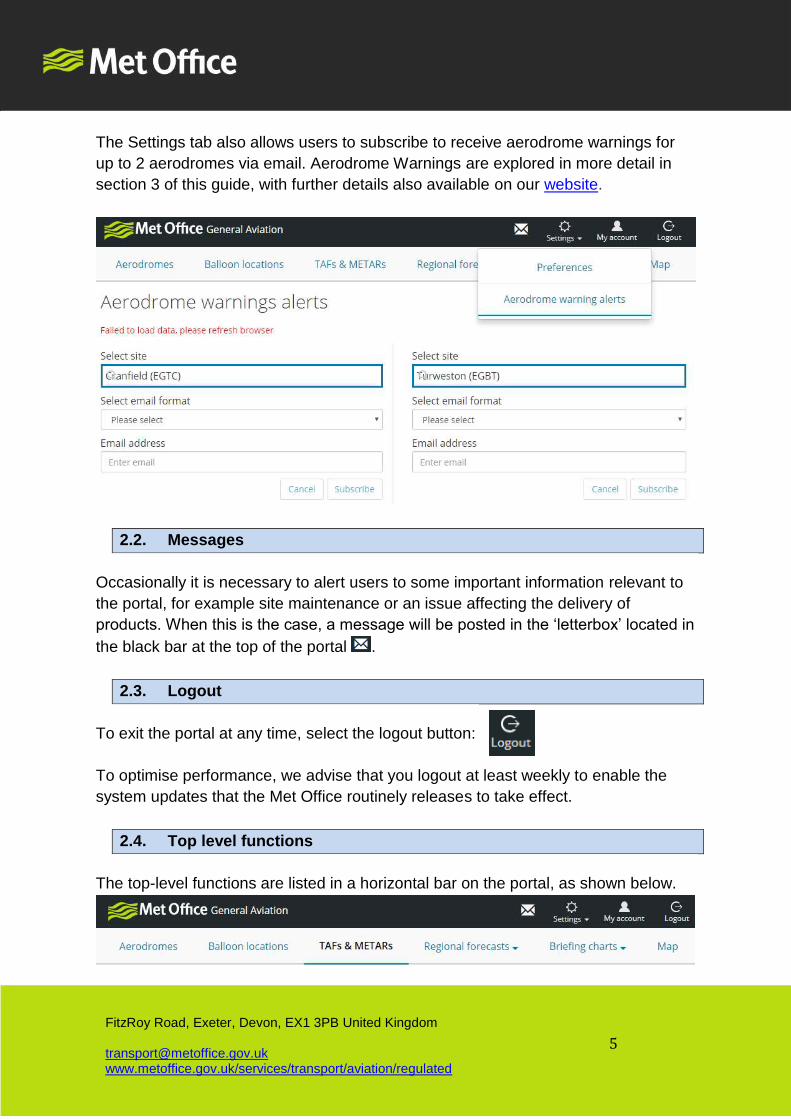
The Settings tab also allows users to subscribe to receive aerodrome warnings for
up to 2 aerodromes via email. Aerodrome Warnings are explored in more detail in
section 3 of this guide, with further details also available on our website.
2.2. Messages
Occasionally it is necessary to alert users to some important information relevant to
the portal, for example site maintenance or an issue affecting the delivery of
products. When this is the case, a message will be posted in the ‘letterbox’ located in
the black bar at the top of the portal .
2.3. Logout
To exit the portal at any time, select the logout button:
To optimise performance, we advise that you logout at least weekly to enable the
system updates that the Met Office routinely releases to take effect.
2.4. Top level functions
The top-level functions are listed in a horizontal bar on the portal, as shown below.
Page 6
6
FitzRoy Road, Exeter, Devon, EX1 3PB United Kingdom [email protected] www.metoffice.gov.uk/services/transport/aviation/regulated
Information on each of these functions are as follows:
Aerodromes
This section provides a quick and easy way to view a range of current information for
a specific aerodrome. Type the name or ICAO for an aerodrome into the box to
receive the following information for that location:
- Latest TAF (if provided)
- Latest METAR (if provided)
- Previous 4 METARs (if provided)
- Any aerodrome warnings issued (if issued)
- The relevant Forecast regional pressure setting
- Sunrise & sunset times
Further detail on TAFs and METARs is available in section 3 of this guide.
If you have location settings enabled on your tablet or smartphone you can ‘use your
current location’ to view this data for your nearest aerodrome.
The most recent aerodromes that you have searched for will remain available to
reselect without typing in the aerodrome name.
The Met Office provide aerodrome warnings for over 100 aerodromes. So
even if you are operating to/from a small airfield that does not issue METARs
or receive TAFs, pilots will still likely be able to access warnings of a range of
significant weather conditions for that airfield including strong wind, gale, fog, frost,
thunderstorms, hail, squall, snow and frost. Further details on aerodrome warnings is
available on our website and in section 3 of this guide.
Page 7
7
FitzRoy Road, Exeter, Devon, EX1 3PB United Kingdom [email protected] www.metoffice.gov.uk/services/transport/aviation/regulated
Balloon locations
This section has been specifically designed for balloonists, and the products are
described in more detail in section 3 of this guide.
The principle for accessing forecasts for locations used by balloonists is similar to
accessing aerodrome information; starting to type a ballooning location will allow a
balloonist to select the site they require a forecast for. An option exists to view a list
and details of all the ballooning sites for which forecasts are provided.
If you have location settings enabled on your tablet or smartphone you can ‘use your
current location’ to view forecast data for the nearest ballooning site for which
forecasts are provided.
The most recent ballooning locations that you have searched for will remain
available to reselect without typing in the location name.
A range of balloon forecast definitions information is also available from this page,
including thermal strength, lee waves strength and wind shear.
Ballooning forecasts are designed to provide additional information relevant to
the specific requirements of balloonists and which is not included in other
forecasts. These forecasts are therefore intended to be a supplement to, and not a
substitute for other briefing information available, including AIRMETs and F215. The
forecasts are not amended once issued.
TAFs & METARs
This section allows pilots to view geographical lists of TAFs and or METARs.
Further detail on TAFs and METARs are provided in section 3 of this guide.
A global search function exists if the aerodrome you are looking for is now available
in the list.
Page 8
8
FitzRoy Road, Exeter, Devon, EX1 3PB United Kingdom [email protected] www.metoffice.gov.uk/services/transport/aviation/regulated
Regional Forecasts
This section allows pilots to access a range of area forecasts for the UK, including
SIGMETs, AIRMETs, Volcanic Ash Advisories, Regional Pressure Settings and
London CTA helicopter forecasts. Each of these products are described in section 3
of this guide.
Briefing Charts
This section allows pilots to access a range of UK and international weather
forecasts in chart form, including Surface Pressure (synoptic charts), Low Level
significant weather charts & spot winds, Upper level significant weather charts and
upper wind and temperature charts.
Each of these products are described in more detail in section 3 of this guide.
Map
This section takes users to the interactive map portal from which an extensive range
of observation and forecast data produced by Met Office models are available as
map overlays.
These layers are explored in more detail in section 4 of this guide.
Page 9
9
FitzRoy Road, Exeter, Devon, EX1 3PB United Kingdom [email protected] www.metoffice.gov.uk/services/transport/aviation/regulated
Cloud heights in map layers are referenced to height above ground level.
Forecast information on map layers are automated and derived solely from Met
Office models and have no forecaster input to fine tune the data. As such, these
layers are intended to provide broad guidance, and ideally should form part of a
wider briefing that takes account of the scope of information available on the web
site.
Map layer data will auto-refresh every 5 minutes. On each auto-refresh the
website will check whether new model data has come in, and if appropriate it
will update the map layers with this new data. A refresh may be ‘forced’ by clicking
the refresh button or F5 on your browser.
The exact time at which model data comes into the website may vary slightly
from day to day.
2.5. Quick Link shortcuts
The grey section in the bottom half of the portal provides users with access to range
of products via a number of ‘quick links’. These include briefing charts and commonly
used weather map layers. Selecting any of these links will take to directly through to
that product/map layer.
2.6. Additional Information
The black horizontal bar at the foot of the portal provides access to a range of non-
forecast information including:
- Frequently Asked Questions
- Guides
Page 10
10
FitzRoy Road, Exeter, Devon, EX1 3PB United Kingdom [email protected] www.metoffice.gov.uk/services/transport/aviation/regulated
- Links to national severe weather warning
- Supported browsers, and
- How to contact and provide feedback
These are designed to provide some additional information to help users get the
most from the briefing portal.
3. Aviation Briefing Products
3.1. TAF & METAR lists
What information does the product provide to pilots?
TAFs provide a concise summary of the most likely range weather conditions that
pilots can expect at an aerodrome throughout their period of validity.
METARs provide a snapshot of the wind, visibility, weather, cloud, temperature and
pressure at an aerodrome at a specific time. METARs are normally produced by
qualified observers, and many airports increasingly use automated instrumentation.
When is the product issued?
TAFs are routinely issued every 3 or every 6 hours, depending on the validity period
of each TAF. TAFs are issued approximately 1 hour prior to the when they become
valid. The issuance of a TAF is dependent upon the provision of regular and
compliant METARs. All aerodromes generating METARs will normally have TAFs
provided. For aerodromes that do not provide METARs 24/7 a TAF is issued shortly
after the commencement of METARs in the morning.
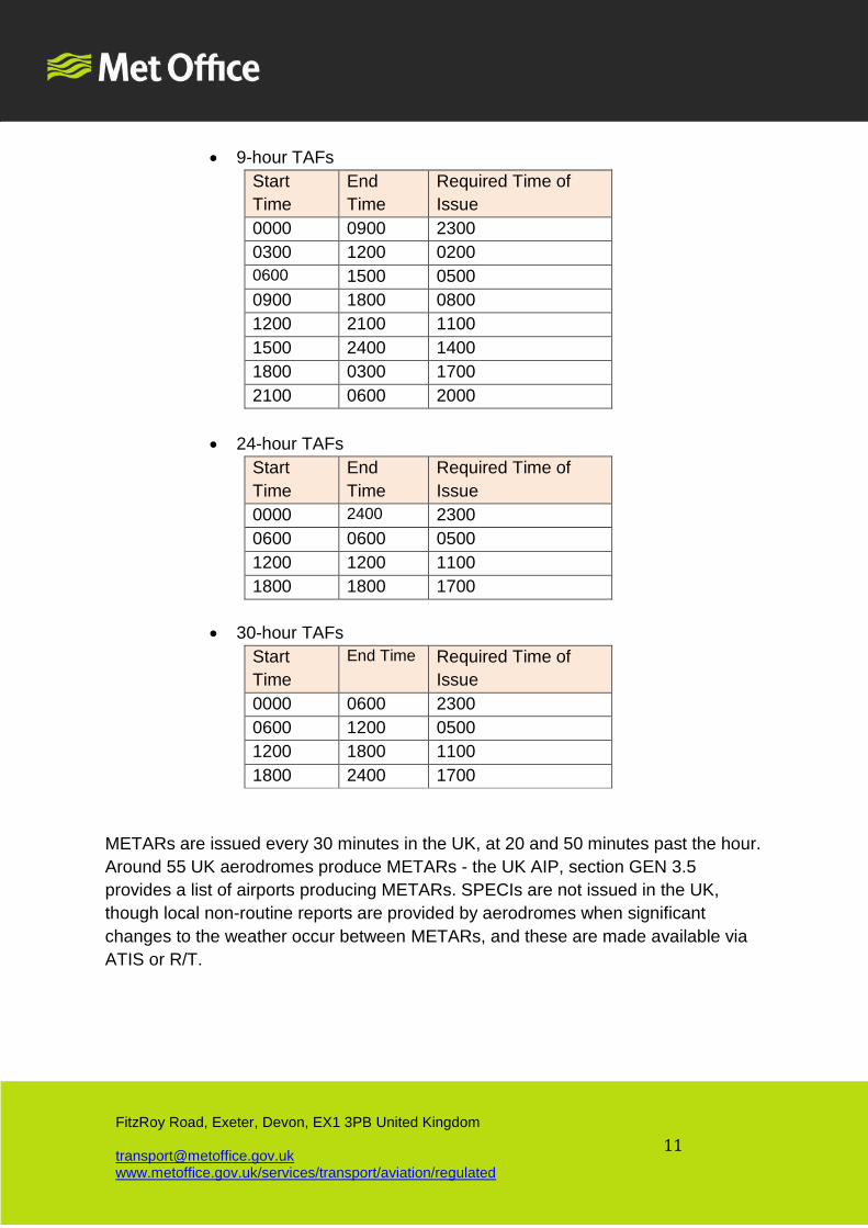
The TAF issue times are as follows:
Page 11
11
FitzRoy Road, Exeter, Devon, EX1 3PB United Kingdom [email protected] www.metoffice.gov.uk/services/transport/aviation/regulated
• 9-hour TAFs
Start
Time
End
Time
Required Time of
Issue
0000 0900 2300
0300 1200 0200
0600 1500 0500
0900 1800 0800
1200 2100 1100
1500 2400 1400
1800 0300 1700
2100 0600 2000
• 24-hour TAFs
Start
Time
End
Time
Required Time of
Issue
0000 2400 2300
0600 0600 0500
1200 1200 1100
1800 1800 1700
• 30-hour TAFs
Start
Time
End Time Required Time of
Issue
0000 0600 2300
0600 1200 0500
1200 1800 1100
1800 2400 1700
METARs are issued every 30 minutes in the UK, at 20 and 50 minutes past the hour.
Around 55 UK aerodromes produce METARs - the UK AIP, section GEN 3.5
provides a list of airports producing METARs. SPECIs are not issued in the UK,
though local non-routine reports are provided by aerodromes when significant
changes to the weather occur between METARs, and these are made available via
ATIS or R/T.
Page 12
12
FitzRoy Road, Exeter, Devon, EX1 3PB United Kingdom [email protected] www.metoffice.gov.uk/services/transport/aviation/regulated
Validity period of the product
TAFs have a minimum validity period of 2 hours. Normally TAFs are valid for either
9, 24 or 30 hours. The validity period of TAFs is determined by the CAA, taking
account of the nature of air traffic operating to each airport.
METARs are only valid at the time they are produced. As soon as they are issued,
they are effectively out of date.
Remember that TAFs and METARs reflect the forecast and actual weather
conditions at the aerodrome. The weather conditions en-route are often likely
to vary markedly from the weather at your departure and arrival aerodromes, so
don’t plan your flight without considering the en-route conditions.
The values provided in TAFs are commonly thought to represent the exact
forecast conditions for a specific time. In fact, whilst those values are the most
likely expected, they account for a range of potential values. For more information on
TAFs, please take a look at What do TAFs values really mean? TAFs are
continuously monitored and subject to amendment criteria when the conditions
deviate beyond the prescribes limits. TAF amendments are required to be issued
within 15 minutes of when significant un-forecast weather occurs, or on receipt of a
METAR that breaches the TAF. This amendment criteria are described in the UK
AIP, section GEN 3.5. and GetMet.
Did you know that the accuracy of TAFs are monitored by the Met Office,
along with a range of other measures that we assess? The results are
published and can be viewed in the Aviation Forecast Performance page of our
website.
Page 13
13
FitzRoy Road, Exeter, Devon, EX1 3PB United Kingdom [email protected] www.metoffice.gov.uk/services/transport/aviation/regulated
Example
Page 14
14
FitzRoy Road, Exeter, Devon, EX1 3PB United Kingdom [email protected] www.metoffice.gov.uk/services/transport/aviation/regulated
3.2. Regional Forecasts
3.2.1. SIGMETs
What information does the product provide to pilots?
SIGMETs provide abbreviated plain language information on a range of reported or
forecast en-route weather that may be hazardous to aviation. The Met Office is
designated by ICAO as a Meteorological Watch Office (MWO) and as such is
responsible for issuing SIGMETs for 3 UK FIRs (London, Scottish and Shanwick).
The range of weather covered by SIGMETs issued by the Met Office includes:
• Thunderstorm (TS)
• Severe Turbulence (SEV TURB), to include SEV CAT and SEV Low
Level Turbulence
• Icing
• Mountain Wave (SEV MTW)
• Volcanic Ash (VA)
SIGMETs issued by other State Meteorological service providers are available to
premium subscribers.
The phenomenon that UK airspace experienced on 16th October 2017, during
which smoke from forest fires on the Iberian Peninsula were drawn up into UK
airspace, impacted the operation of several aircraft. Therefore, and following
discussions with the Met Authority, CAA, the Met Office have commenced the
provision of ‘Smoke SIGMETs’ to provide timely information on this potential hazard
to aviators in the event of a widespread smoke event in future. Please refer to the
Provision of 'Smoke' SIGMETs document for more information.
When is the product issued?
A SIGMET will be issued when the conditions listed above are expected to occur
within the FIRs that the Met Office is responsible, or upon receipt of an AIREP (Air
Report) provided by an airline.
Validity period of the product
SIGMETs are normally valid for a maximum of 4 hours.
Page 15
15
FitzRoy Road, Exeter, Devon, EX1 3PB United Kingdom [email protected] www.metoffice.gov.uk/services/transport/aviation/regulated
Example
Page 16
16
FitzRoy Road, Exeter, Devon, EX1 3PB United Kingdom [email protected] www.metoffice.gov.uk/services/transport/aviation/regulated
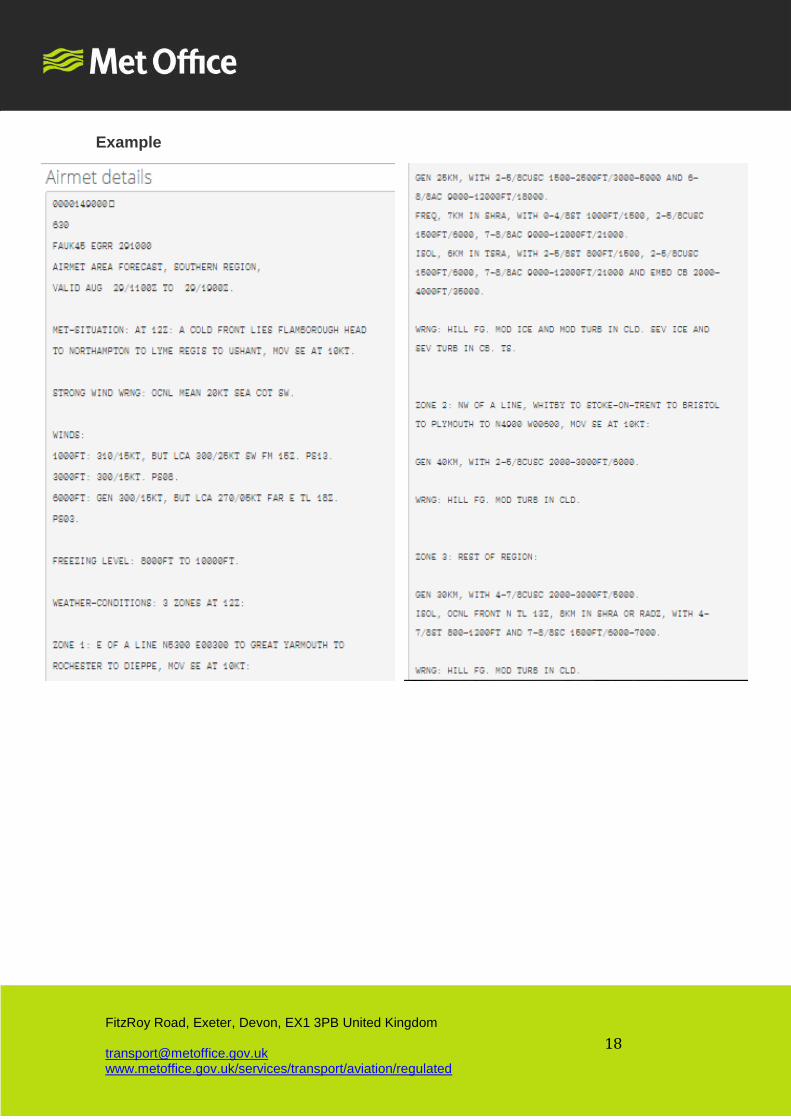
3.2.2 AIRMETs
What information does the product provide to pilots?
AIRMETs are semi plain language regional low-level forecasts for the UK. They
describe the following meteorological aspects:
• Met situation
• Strong wind warning (surface winds greater than 20 knots, including gusts)
• Winds
• Freezing level
• Weather including visibility, present weather and cloud information
• Warnings of significant meteorological phenomena
• Outlook for the following period
The Met Office provides 10 such forecasts, covering different parts of the UK and
including specific forecasts of significant weather, outlook and upper wind
information:
• AIRMET Central England
• AIRMET Cross Channel
• AIRMET Northern England
• AIRMET Scotland
• AIRMET South East England
• AIRMET South West England
• AIRMET Southern England
• AIRMET UK Significant Weather
• AIRMET UK Update & Outlook
• AIRMET UK Upper Winds
The content of AIRMETs are designed to be broadly consistent with the content of
the F215 (low level significant weather charts).
When is the product issued?
AIRMETs are issued either up to 4 times each day, as follows:
Page 17
17
FitzRoy Road, Exeter, Devon, EX1 3PB United Kingdom [email protected] www.metoffice.gov.uk/services/transport/aviation/regulated
Regional Area /
Forecast
Update time / Validity period (UTC)
Southern Region 0430 / 05-13 1000 / 11-19 1600 / 17-01 2200 / 23-07
Northern Region 0430 / 05-13 1000 / 11-19 1600 / 17-01 2200 / 23-07
Scottish Region 0430 / 05-13 1000 / 11-19 1600 / 17-01 2200 / 23-07
UK Significant Wx 0530 / 06-12 1130 / 12-18 1730 / 18-24 2330 / 00-06
UK Upper Winds 0530 / 06-12 1130 / 12-18 1730 / 18-24 2330 / 00-06
UK Update &
Outlook
0830 / 09-15 1430 / 15-21 2030 / 21-03 0230 / 03-09
South-west
England
0430 / 06-15 1230 / 13-21 1630 / 17-01
South-east
England
0430 / 06-15 1230 / 13-21 1630 / 17-01
Central England 0430 / 06-15 1230 / 13-21 1630 / 17-01
Cross Channel 0430 / 06-15 1230 / 13-21
Validity period of the product
The validity of AIRMETS are between 6 to 9 hours (depending on the AIRMET).
Page 18
18
FitzRoy Road, Exeter, Devon, EX1 3PB United Kingdom [email protected] www.metoffice.gov.uk/services/transport/aviation/regulated
Example
Page 19
19
FitzRoy Road, Exeter, Devon, EX1 3PB United Kingdom [email protected] www.metoffice.gov.uk/services/transport/aviation/regulated
3.2.3 Volcanic Ash Advisories
What information does the product provide to pilots?
A text-based product (Volcanic Ash Advisory) and equivalent graphic (Volcanic Ash Graphic)
are generated to inform the aviation community of areas affected by volcanic ash
contamination, if volcanic activity results in the release of ash into the atmosphere. These
products will describe the current vertical and horizontal event of ash in the atmosphere, and its
expected trajectory.
The Met Office is one of 9 Volcanic Ash Advisory centres designated by ICAO. Our area of
responsibility covers UK airspace and the north east Atlantic, including Iceland. The Met
Office engages closely with the Icelandic Met Office and uses a dispersion model to help predict
the trajectory of released ash. We can also call upon a civil contingency aircraft and ground
based equipment to observe the concentration and extent of ash.
Hazards from ash include possible engine failure due to ingestion of a range of different sized
volcanic particles that can quickly damage engines to the extent that they may not necessarily
be restarted. Additionally, noxious fumes may affect aircrew and passengers.
Page 20
20
FitzRoy Road, Exeter, Devon, EX1 3PB United Kingdom [email protected] www.metoffice.gov.uk/services/transport/aviation/regulated
When is the product issued?
The objective of these alerts is to prevent flight into hazardous volcanic ash, so these products
are issued as quickly as is possible following an eruption. Subsequent issues will be issued at
0030, 0630, 1230 and 1830 for as long as the eruption and/or ash continues to exist and pose a
hazard.
Validity period of the product
The products will be valid for 6 hourly timesteps (T+0, T+06, T+12 and T+18). The product will
be re-issued if there are significant changes to the eruption strength, particularly increases in
eruption activity.
Example
3.2.4 Regional Pressure Settings
What information does the product provide to pilots?
This product provides a forecast of the lowest pressure expected to occur in the hour HH+1hour
to HH+2hours for several defined areas, as described below.
Puffin Shetland Marlin Skerry Petrel
Portree Orkney Rattray Belfast Tyne
Skua Holyhead Barnsley Humber Scillies
Wessex Cotswold Chatham Yarmouth Portland
When is the product issued?
These forecasts are issued hourly, between 70 to 75 minutes prior to their validity.
Page 21
21
FitzRoy Road, Exeter, Devon, EX1 3PB United Kingdom [email protected] www.metoffice.gov.uk/services/transport/aviation/regulated
Validity period of the product
One hour.
Be aware/did you know
An illustration of the geographical extent of each area is provided in the UK AIP (ENR
section) and reproduced below.
Page 22
22
FitzRoy Road, Exeter, Devon, EX1 3PB United Kingdom [email protected] www.metoffice.gov.uk/services/transport/aviation/regulated
Page 23
23
FitzRoy Road, Exeter, Devon, EX1 3PB United Kingdom [email protected] www.metoffice.gov.uk/services/transport/aviation/regulated
Example
3.2.5 London CTA Helicopter forecast
What information does the product provide to pilots?
This is an area forecast covering the London CTA, provided to support commercial, private and
emergency helicopter operations.
The forecast draws attention to the potential for one or more of the following meteorological
thresholds to be breached:
• A cloud base of 1000 feet or less;
• Surface visibility of 3000 metres or less.
Page 24
24
FitzRoy Road, Exeter, Devon, EX1 3PB United Kingdom [email protected] www.metoffice.gov.uk/services/transport/aviation/regulated
A colour-coded summary of the forecast risk is presented, describing the extent and period that
either of the above thresholds are expected to be breached. The forecast also summarises the
freezing level over the forecast area and an outlook.
The overall area covered is the London CTR and London/City CTR as published in the UK AIP.
This area is split into 4 zones, with advisories issued for each zone
When is the product issued?
The forecasts are issued routinely every 6 hours, but may also be amended subject to defined
criteria:
Time of Issue (UTC)
0215-0230
0815-0830
1415-1430
2015-2030
Validity period of the product
Time of Issue (UTC) Validity Period (UTC) Outlook (UTC)
0215-0230 0300-0900 0900-1500
0815-0830 0900-1500 1500-2100
1415-1430 1500-2100 2100-0300
2015-2030 2100-0300 0300-0900
Be aware/did you know
The thresholds that these forecasts focus on are intended to help helicopter operators
mitigate the risk of flight into high buildings and other obstacles over the London area.
Page 25
25
FitzRoy Road, Exeter, Devon, EX1 3PB United Kingdom [email protected] www.metoffice.gov.uk/services/transport/aviation/regulated
Example
Page 26
26
FitzRoy Road, Exeter, Devon, EX1 3PB United Kingdom [email protected] www.metoffice.gov.uk/services/transport/aviation/regulated
3.3 Briefing charts
3.3.1 Surface Pressure
What information does the product provide to pilots?
These charts display the current and forecast synoptic situation over Europe and the Atlantic.
Each display offers the user the ability to view the synoptic situation for the following 3 days (5
days for premium subscribers). The charts provide a useful top-level summary of the current
and forecast synoptic situation over the UK and North Atlantic and can be used to assess the
likely track of deep depressions, which might present some operational challenges.
When is the product issued?
These charts are updated twice per day.
Validity period of the product
The synoptic charts are valid at 1200 UTC and 2400 UTC each day.
Be aware/did you know
Having a basic understanding of fronts and air masses can be incredibly useful in providing
a top-level overview of the weather. Whilst no two front or air masses are identical, they do
provide several common weather features. For more information on interpreting synoptic charts,
weather fronts and air masses, please visit the Pilot resources page of our website.
Example
Page 27
27
FitzRoy Road, Exeter, Devon, EX1 3PB United Kingdom [email protected] www.metoffice.gov.uk/services/transport/aviation/regulated
3.3.2 Significant Weather (Low level) & Spot Winds
a. Significant Weather (Low level)
What information does the product provide to pilots?
The purpose of these charts is to display both graphically and alphanumerically areas of weather
across the UK. Information supplied by these charts covers the expected conditions between the
surface and 10,000ft. The chart is commonly referred to as a F215, and often conveys a great
deal of weather information on a single page, so abbreviated plain language is used.
On the left-hand side of the chart a map provides the forecast positions of the fronts, their speed
of movement and areas of weather for a specified validity time.
On the right-hand side of the chart, the areas of weather are highlighted as A, B, C etc.
Alongside these, a description of surface visibility, weather and cloud is provided. Finally, the
height of the 0 Celsius isotherm for each area is shown on the right. Additional information on
likely icing and turbulence is also provided.
These charts are a staple of the GA community and are used to highlight areas of poor visibility,
and low cloud that pilots may wish to avoid along their flying route.
When is the product issued?
Issued 4 times a day, every 6 hours.
Validity period of the product
Validity time Approx time of update
2000 UTC to 0500 UTC Daily at about 1530
0200 UTC to 1100 UTC Daily at about 2130
0800 UTC to 1700 UTC Daily at about 0330
1400 UTC to 2300 UTC Daily at about 0930
Be aware/did you know
A detailed decode and worked example of a F215 is available in the Pilot resources page
of our website.
Remember, the heights provided on these charts are reference to mean sea level. Please
consider the ground elevation along the route that you are taking.
Page 28
28
FitzRoy Road, Exeter, Devon, EX1 3PB United Kingdom [email protected] www.metoffice.gov.uk/services/transport/aviation/regulated
Page 29
29
FitzRoy Road, Exeter, Devon, EX1 3PB United Kingdom [email protected] www.metoffice.gov.uk/services/transport/aviation/regulated
Page 30
30
FitzRoy Road, Exeter, Devon, EX1 3PB United Kingdom [email protected] www.metoffice.gov.uk/services/transport/aviation/regulated
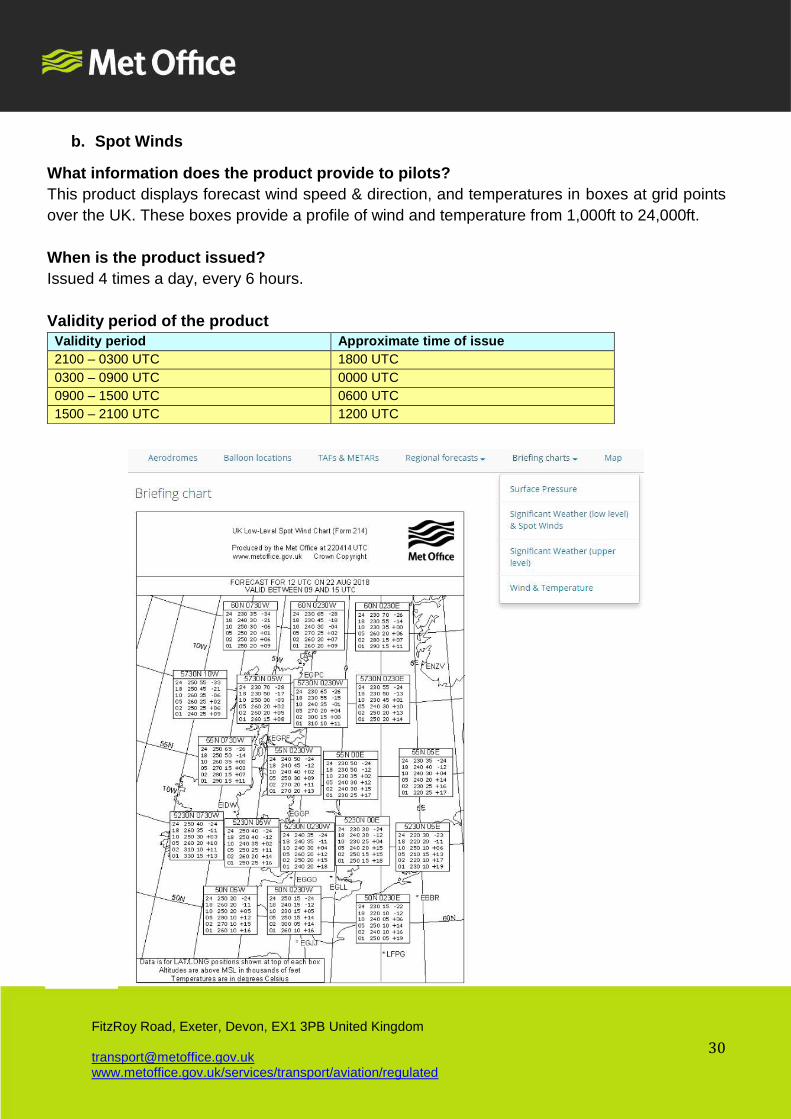
b. Spot Winds
What information does the product provide to pilots?
This product displays forecast wind speed & direction, and temperatures in boxes at grid points
over the UK. These boxes provide a profile of wind and temperature from 1,000ft to 24,000ft.
When is the product issued?
Issued 4 times a day, every 6 hours.
Validity period of the product
Validity period Approximate time of issue
2100 – 0300 UTC 1800 UTC
0300 – 0900 UTC 0000 UTC
0900 – 1500 UTC 0600 UTC
1500 – 2100 UTC 1200 UTC
Page 31
31
FitzRoy Road, Exeter, Devon, EX1 3PB United Kingdom [email protected] www.metoffice.gov.uk/services/transport/aviation/regulated
3.3.3 Significant Weather (upper level) – Premium subscribers only
What information does the product provide to pilots?
Forecasts of Upper level significant weather phenomena are provided as charts for several
regions covering the globe.
The regions covered are as follows:
• EURSAM (ICAO Area B) FL250-FL630
• EURAFI (ICAO Area C) FL250-FL630
• EURASIA (ICAO Area D) FL250-FL630
• INDOC (ICAO Area E) FL250-FL630
• MID (ICAO Area G) FL250-FL630
• NAT (ICAO Area H) FL250-FL630
• SIO (ICAO Area K) FL250-FL630
• EUR FL100-FL450
• MID FL100-FL450
• ASIA SOUTH FL100-FL450
When is the product issued?
Charts are updated four times per day at the following times
Time of issue (UTC) Model data used
between 0640 to 0655 UTC 0000
between 1240 to 1255 UTC 0600
between 1840 to 1855 UTC 1200
between 0040 to 0055 UTC 1800
Validity period of the product
The charts are provided for 'fixed validity times' at 6 hourly intervals for the next 24 hours. The
forecasts are 'usable' for a period extending from 3 hours before to 3 hours after the stated
'fixed' validity time.
Be aware/did you know
The Met Office is one 2 World Area Forecast Centres (WAFC), which are responsible for
producing global upper level wind, temperature and significant weather products. The
other is WAFC Washington.
Guidance on interpreting the features commonly seen on these charts is provided in Pilot
resources.
Page 32
32
FitzRoy Road, Exeter, Devon, EX1 3PB United Kingdom [email protected] www.metoffice.gov.uk/services/transport/aviation/regulated
Example
Page 33
33
FitzRoy Road, Exeter, Devon, EX1 3PB United Kingdom [email protected] www.metoffice.gov.uk/services/transport/aviation/regulated
3.3.4 Wind & Temperature – Premium subscribers only
What information does the product provide to pilots?
Upper level gridded wind and temperature charts are provided for 3 regions: Europe (EUR),
North Atlantic (NAT) and middle east (MID). Data is selectable for 9 difference flight levels.
When is the product issued?
Charts are updated four times per day at the following times
Time of issue (UTC) Model data used
between 0330 to 0420 UTC 0000
between 0930 to 1020 UTC 0600
between 1530 to 1620 UTC 1200
between 2130 to 2220 UTC 1800
Validity period of the product
The charts are provided for 'fixed validity times' at 6 hourly intervals for the next 24 hours. The
forecasts are 'usable' for a period extending from 3 hours before to 3 hours after the stated
'fixed' validity time.
Example
Page 34
34
FitzRoy Road, Exeter, Devon, EX1 3PB United Kingdom [email protected] www.metoffice.gov.uk/services/transport/aviation/regulated
3.4 Balloonists forecasts
What information does the product provide to pilots?
a. Ballooning forecasts provide specific meteorological information, not available from other
more general forecasts, to enable balloonists to safely plan both commercial and private
flights.
Forecasts are provided for 91 locations in hourly timesteps, and the following information is
included in these forecasts:
i. Wind speed and direction at SFC, 500ft, 1000ft and 2000ft
ii. Air temperature at SFC, 500ft, 1000ft and 2000ft
iii. Thermal strength
iv. Wind shear
v. Pressure (QNH)
vi. Humidity
The product also provides local area forecasts of rotors, lee waves, inversions, sea
breeze activity, outlook and summary.
b. Additionally, regional ‘graphical wind and temperature profiles’ for each balloon launch site
are provided. Wind and temperature information is presented for 500, 1000 and 2000 feet
above ground level.
When is the product issued?
a. Ballooning text forecast issue times and periods of validity are as follows:
Winter Schedule (applicable between 16 October to 14 March)
Forecast Issue time (local)* Period of
validity
Outlook
Morning 20:30 previous day 05:00-10:00 Midday to Dusk
Morning 02:30 06:00-11:00 Midday to Dusk
Afternoon/Evening 08:30 12:00-17:00 Dawn to Midday next
day
Afternoon/Evening 14:30 12:00-17:00 Dawn to Midday next
day
Page 35
35
FitzRoy Road, Exeter, Devon, EX1 3PB United Kingdom [email protected] www.metoffice.gov.uk/services/transport/aviation/regulated
Summer Schedule (between 15 March to 15 October)
Forecast Issue time (local)* Period of
validity
Outlook
Morning 20:30 previous day 05:00-10:00 Three hours before
dusk until dusk
Morning 02:30 05:00-10:00 Three hours before
dusk until dusk
Afternoon/Evening 08:30 16:00-21:00 Dawn to 3 hours after
dawn next day
Afternoon/Evening 14:30 16:00-21:00 Dawn to 3 hours after
dawn next day
b. Regional graphical wind & temperature profiles:
The product is valid at 0600 and 1800 UTC between 15 March and 15 October and at 0900 and
1500 UTC between 16 October and 14 March). They updated at 0230, 0830, 1430 and 2030
UTC.
*note that all times are UTC and that updated forecasts will be available on the website after a
short period after the time of issue
Validity period of the product
Please see above.
Be aware/did you know
The Met Office and CAA have summarised the information available for balloonists and a
sensible approach to pre-flight briefing in this document.
Gusts: The wind gust values used in the ballooning forecasts are calculated from a high-
resolution model and should give a good guide to gusts in the type of light wind conditions
that balloonists are interested in. However, there are a few things to be aware of:
• When the mean wind speed is >15kt the gust speeds shown tend to be higher than is
realistic. Please note that where you see gust speeds elsewhere on Met Office products
they calculate gust speeds in a different way, which gives more accurate values at higher
mean wind speeds.
• The high-resolution model used to calculate the gust speeds can forecast heavy
showers/thunderstorms and downdraughts. This means that from time to time there may
be an unusually strong gust shown for a forecast site near to one of these predicted
Page 36
36
FitzRoy Road, Exeter, Devon, EX1 3PB United Kingdom [email protected] www.metoffice.gov.uk/services/transport/aviation/regulated
showers/thunderstorms when in general the forecast winds are light. Please be aware that
showers/thunderstorms may not always form in the exact location shown in the forecast, and
the potential for these strong gusts will move with it.
Example
Page 37
37
FitzRoy Road, Exeter, Devon, EX1 3PB United Kingdom [email protected] www.metoffice.gov.uk/services/transport/aviation/regulated
Page 38
38
FitzRoy Road, Exeter, Devon, EX1 3PB United Kingdom [email protected] www.metoffice.gov.uk/services/transport/aviation/regulated
4 Map weather layers
4.3 Basic Functionality
The interactive map feature allows users to select from an extensive range of observation
and forecast model data. The area covered by the map may be increased or decreased by
using the control or the curser (or using finders on mobile devices). The map may also be
panned.
As described in para 2.1 of this guide, default map settings may be selected to show
aerodromes, ballooning locations, both or neither, as well as showing aerodromes by their
ICAO indicator and/or name.
Selection the icon allows additional information to be provided on whatever weather
information is currently being displayed.
Example of additional information presented by selecting the icon.
Page 39
39
FitzRoy Road, Exeter, Devon, EX1 3PB United Kingdom [email protected] www.metoffice.gov.uk/services/transport/aviation/regulated
Selecting the icon allows you to view the list of weather layers that can be selected.
This list is expandable.
Example of weather map layers presented by selecting the icon.
When selecting a weather layer from the list, a time sequence will be available at the foot of
the map. This allows users to either run the forecast/observation sequence or select a
specific point in time.
The takes the user out of the map section back to your default ‘landing page’.
Where aerodromes have been selected from the preferences setting, these will be
presented as coloured circles on the map. These colours are based on the visibility, cloud
base and amount in the latest METAR and are updated following every new METAR issued.
Colour coding is a good way of ascertaining quickly the conditions over an area without
viewing the full observation. A definition of the meaning of each colour is shown in the
icon.
Page 40
40
FitzRoy Road, Exeter, Devon, EX1 3PB United Kingdom [email protected] www.metoffice.gov.uk/services/transport/aviation/regulated
Military airfield reports also display a colour state in their METARs - BLU, WHT, GRN,
YLO1, YLO2, AMB or RED according to cloud base and visibility. These thresholds are
different to the colours used to display the observations in the GA product. BLACK indicates
the runway is unusable.
A summary of the differences is shown in the table below:
Aerodrome colour state code (shown in METARs
from military airfields)
Aerodrome colour state code
(shown on website)
Aerodrome
colour state
minimum weather conditions minimum weather conditions
Surface
visibility
Base of lowest cloud
layer of 3/8 (or SCT)
or more in heights
above ground level
Surface
visibility
Base of lowest cloud
layer of 5/8 (or BKN)
or more in heights
above ground level
Blue (BLU) 8 KM 2500 FT 10 KM 1500 FT
White (WHT) 5000 M 1500 FT 5000 M 1200 FT
Green (GRN) 3700 M 700 FT 4000 M 600 FT
Yellow 1
(YLO1) 2500 M 500 FT
Yellow 2
(YLO2) 1600 M 300 FT
Amber
(AMB) 800 M 200 FT 500 M 200 FT
Red (RED)
Less
than 800
M
Below 200 FT or Sky
obscured
Less
than 500
M
Below 200 FT or Sky
obscured
Black Observation not available
Aerodromes that have a red triangle over their circles indicate that an aerodrome warning
has been issued for this location.
Aerodrome warnings are issued by the Met Office according to a set of pre-determined forecast
conditions. They are as follows:
STRONG WIND
Issued when a strong wind with a mean of 20KT and/or gusts of 28KT is expected at the airfield.
Page 41
41
FitzRoy Road, Exeter, Devon, EX1 3PB United Kingdom [email protected] www.metoffice.gov.uk/services/transport/aviation/regulated
GALE
Issued when a strong wind with a mean of 34KT and/or gusts of 43KT is expected at the airfield.
FROST
Issued when either:
• an air frost (air temperature of 0oC or lower) is expected at the airfield
• a ground frost (a surface temperature of 0oC or lower) is expected at the airfield
• a ground and air frost (a surface and air temperatures of 0oC or lower) is expected at the
airfield
SNOW
Issued in advance of a snow event.
FOG
Issued when fog or freezing fog is expected to reduce visibility to less than 600m.
THUNDERSTORM
Issued when a thunderstorm, with hail and or squall is expected at, or within 5nm of the airfield.
HAIL
Issued when hail is expected at, or within 5nm of the airfield.
FREEZING PRECIPITATION
Issued when freezing precipitation is expected to fall at the airfield.
TEMPERATURE INVERSION
Issued when a temperature inversion of 10ºC or more is expected to exist in the lowest 1000 FT.
Further detail on aerodrome warnings, including the phraseology used and how to use these in
conjunction with TAFs, is available in the Pilot resources page of our website.
Selecting an aerodrome from the map will display a box in the top right-hand side of the screen
showing the latest METAR and any valid aerodrome warnings issued. The age of the latest
METAR issued is also shown. The box allows users the option to view further additional
information outside of the map if required.
Selecting a ballooning location from the map will take the user out of the map to ballooning
forecast for that site.
Page 42
42
FitzRoy Road, Exeter, Devon, EX1 3PB United Kingdom [email protected] www.metoffice.gov.uk/services/transport/aviation/regulated
4.4 Current weather
4.4.1 UK Radar
What information does the layer provide to pilots?
High resolution detail of rainfall distribution, intensity and movement over the UK.
Areas of heavier precipitation are a likely indication of a low cloud base. Use rainfall
radar to consider whether low cloud is likely to present a hazard along your route.
Timesteps provided
Every 15 minutes for the previous 3 hours
(5-minute updates for the most recent hour, for premium subscribers).
Data source
UK rainfall radar composite
Data update frequency
Every 15 minutes (every 5 minutes for premium subscribers).
Example
Page 43
43
FitzRoy Road, Exeter, Devon, EX1 3PB United Kingdom [email protected] www.metoffice.gov.uk/services/transport/aviation/regulated
4.4.2 European Radar – Premium subscribers only
What information does the layer provide to pilots?
Distribution, intensity and movement of precipitation over north western Europe.
Timesteps provided
Every 15 minutes for the previous 3 hours
Data source
European composite radar
Data update frequency
Every 15 minutes
Example
Page 44
44
FitzRoy Road, Exeter, Devon, EX1 3PB United Kingdom [email protected] www.metoffice.gov.uk/services/transport/aviation/regulated
4.4.3 Lightning
What information does the layer provide to pilots?
The distribution and timing of lightning detected by the Met Office’s lightning detection
system.
Most lightning detected is cloud-to-ground activity. Some intra-cloud (or cloud-to-
cloud) activity may also be detected
Timesteps provided
Every 15 minutes for the previous 3 hours
Data source
The Met Office’s lightning detection system, called ATDNet.
Data update frequency
Every 5 minutes
Page 45
45
FitzRoy Road, Exeter, Devon, EX1 3PB United Kingdom [email protected] www.metoffice.gov.uk/services/transport/aviation/regulated
4.2.4 Visible Satellite – Premium subscribers only
What information does the layer provide to pilots?
Satellite imagery in the visible wavelength (daytime only)
The structure of clouds in satellite images can inform pilots a lot about the weather, and
animated sequences can tell pilots about the movement of weather systems.
Bands of cloud often indicate the presence of weather fronts, whilst individual clouds are
likely to provide detail on the location of convective clouds. Both frontal and convective cloud
information is useful to pilots because each are often accompanied by potential weather
hazards such as icing, turbulence, hail, and lightning. Gaps in the cloud cover can also
reveal the location of snow fields.
Timesteps provided
Every 15 minutes for the previous 6 hours
Data source
Meteosat Second Generation satellite
Data update frequency
Every 15 minutes
Example
Page 46
46
FitzRoy Road, Exeter, Devon, EX1 3PB United Kingdom [email protected] www.metoffice.gov.uk/services/transport/aviation/regulated
4.2.5 Infrared Satellite – Premium subscribers only
What information does the layer provide to pilots?
Satellite imagery from in the infrared wavelength.
Satellites also measure the temperature of the clouds and the surface with an infrared
sensor. This results in infrared satellite imagery.
The thermal contrast between land and cloud tops allows the position of clouds to be
revealed during the hours of darkness. The brightest clouds are those with the greatest
thermal contrast, i.e. those with the highest tops such as CBs. Those with little contrast
with the land have similar thermal differences so are most likely low cloud like stratus, or
fog.
Timesteps provided
Every 15 minutes for the previous 6 hours
Data source
Meteosat Second Generation satellite
Data update frequency
Every 15 minutes
Example
Page 47
47
FitzRoy Road, Exeter, Devon, EX1 3PB United Kingdom [email protected] www.metoffice.gov.uk/services/transport/aviation/regulated
4.2.6 Thunderstorms (day)
What information does the layer provide to pilots?
A combination layer showing both visible satellite imagery and observed lightning.
Timesteps provided
Every 15 minutes for the previous 3 hours
Data source
Meteosat Second Generation satellite & the Met Office’s lightning detection system, ATDNet
Data update frequency
Every 15 minutes
Example
Page 48
48
FitzRoy Road, Exeter, Devon, EX1 3PB United Kingdom [email protected] www.metoffice.gov.uk/services/transport/aviation/regulated
4.2.7 Thunderstorms (night)
What information does the layer provide to pilots?
A combination layer showing both infrared satellite imagery and observed lightning.
Timesteps provided
Every 15 minutes for the previous 3 hours
Data source
Meteosat Second Generation satellite & the Met Office’s lightning detection system,
ATDNet
Data update frequency
Every 15 minutes
Example
Page 49
49
FitzRoy Road, Exeter, Devon, EX1 3PB United Kingdom [email protected] www.metoffice.gov.uk/services/transport/aviation/regulated
4.3 Forecast Wind & Temp
4.3.1 Wind Fletches
What information does the layer provide to pilots?
Gridded mean wind speeds for the UK and Europe at the surface, 2000ft, 5000ft and
10000ft.
Greater detail over an area can be obtained by zooming in.
Each feather shows the direction from which the wind is coming at a particular point. Each large line on a feather represents 10KTs and each half line represents 5KTs. A shaded triangle represents 50KTs. Wind information is provided referenced to degrees true.
Timesteps provided
Every 3 hours from T+0 to T+36 hours, then
Every 6 hours from T+36 hours to T+60 hours, then
Every 12 hours to 5 days ahead.
Data source
Met Office global model
Data update frequency
Model updates every 6 hours, with data available approximately 4.5 hours later (i.e. at 0430,
1030, 1630 & 2230 UTC).
Example
Page 50
50
FitzRoy Road, Exeter, Devon, EX1 3PB United Kingdom [email protected] www.metoffice.gov.uk/services/transport/aviation/regulated
4.3.2 Wind Arrows
What information does the layer provide to pilots?
Gridded mean wind speeds for the UK and Europe at the surface, 2000ft, 5000ft and
10000ft.
Timesteps provided
Every 3 hours from T+0 to T+36 hours, then
Every 6 hours from T+36 hours to T+60 hours, then
Every 12 hours to 5 days ahead.
Data source
Met Office global model
Data update frequency
Model updates every 6 hours, with data available approximately 4.5 hours later (i.e. at
0430, 1030, 1630 & 2230 UTC).
Example
Page 51
51
FitzRoy Road, Exeter, Devon, EX1 3PB United Kingdom [email protected] www.metoffice.gov.uk/services/transport/aviation/regulated
4.3.3 Wind & Temperature
What information does the layer provide to pilots?
Gridded mean wind speeds and temperatures for the UK and Europe at 2000ft, 5000ft
and 10000ft
Timesteps provided
Every 3 hours from T+0 to T+36 hours ahead
Data source
Met Office global model
Data update frequency
Model updates every 6 hours, with data available approximately 4.5 hours later (i.e. at
0430, 1030, 1630 & 2230 UTC).
Example
Page 52
52
FitzRoy Road, Exeter, Devon, EX1 3PB United Kingdom [email protected] www.metoffice.gov.uk/services/transport/aviation/regulated
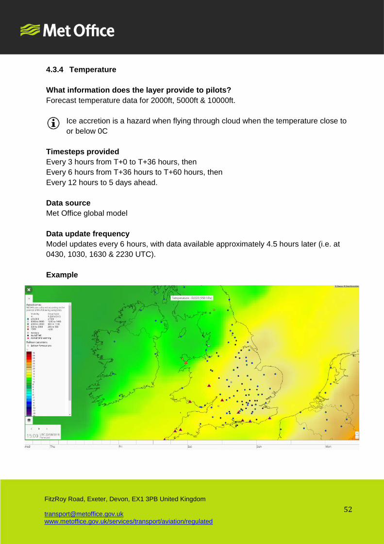
4.3.4 Temperature
What information does the layer provide to pilots?
Forecast temperature data for 2000ft, 5000ft & 10000ft.
Ice accretion is a hazard when flying through cloud when the temperature close to
or below 0C
Timesteps provided
Every 3 hours from T+0 to T+36 hours, then
Every 6 hours from T+36 hours to T+60 hours, then
Every 12 hours to 5 days ahead.
Data source
Met Office global model
Data update frequency
Model updates every 6 hours, with data available approximately 4.5 hours later (i.e. at
0430, 1030, 1630 & 2230 UTC).
Example
Page 53
53
FitzRoy Road, Exeter, Devon, EX1 3PB United Kingdom [email protected] www.metoffice.gov.uk/services/transport/aviation/regulated
4.4 Forecast Precipitation
4.4.1 Precipitation Rate & Pressure
What information does the layer provide to pilots?
This layer uses high resolution modelling (including ‘nowcasting’ for the first 6 hours) to
forecast the movement and intensity of precipitation, and associated pressure pattern.
Nowcasting uses new observation data regularly received into our model to
constantly update and fine tune short term forecasts.
Timesteps provided
Hourly to 36 hours ahead
Data source
UK model
Data update frequency
Data for the first 6 hours updates hourly
The rest of the data is updated at 0300, 0900, 1500 & 2100 UTC
Updated data is available approximately 27 minutes past the hour. The rest of the data
will update approximately 3.5 hours after the model run (i.e. at 0630, 1230, 1830 & 0030
UTC).
Example
Page 54
54
FitzRoy Road, Exeter, Devon, EX1 3PB United Kingdom [email protected] www.metoffice.gov.uk/services/transport/aviation/regulated
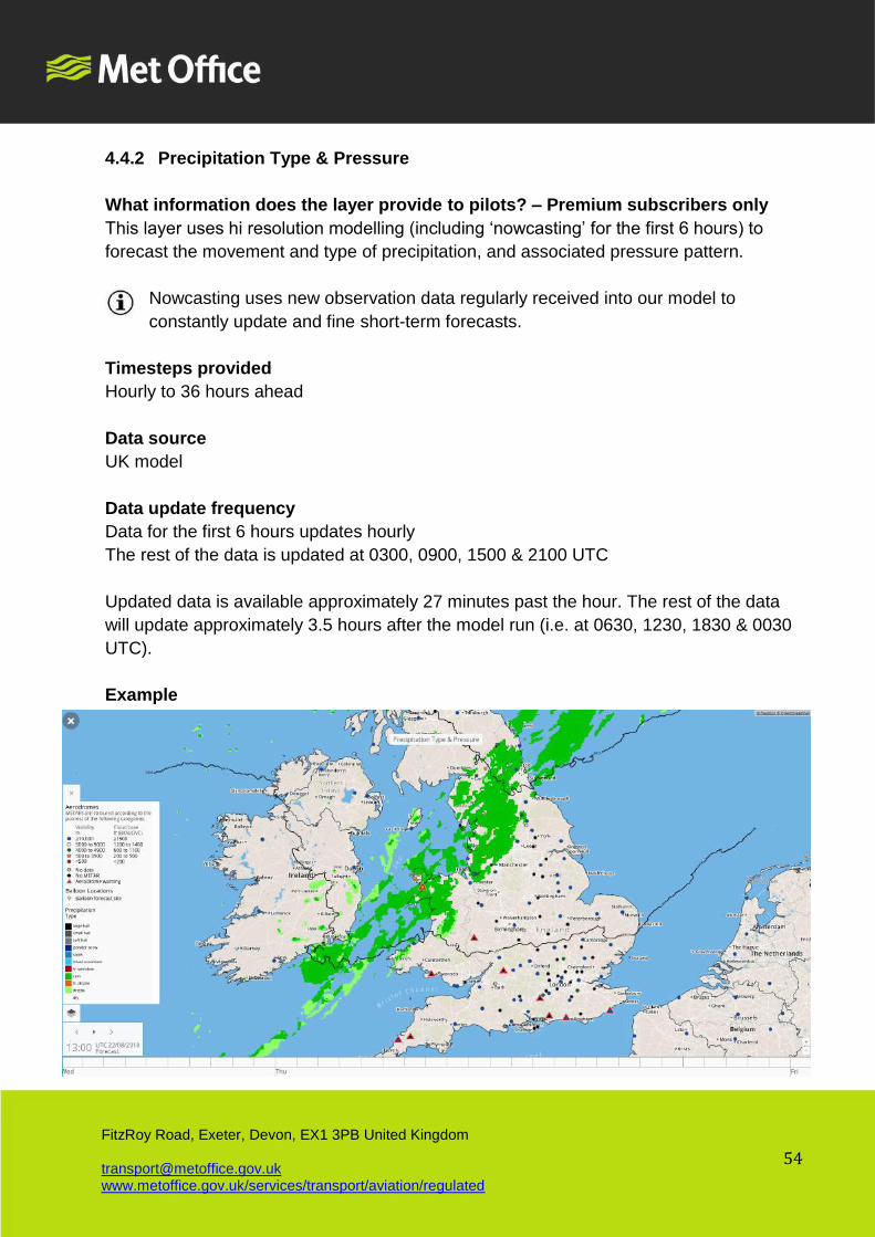
4.4.2 Precipitation Type & Pressure
What information does the layer provide to pilots? – Premium subscribers only
This layer uses hi resolution modelling (including ‘nowcasting’ for the first 6 hours) to
forecast the movement and type of precipitation, and associated pressure pattern.
Nowcasting uses new observation data regularly received into our model to
constantly update and fine short-term forecasts.
Timesteps provided
Hourly to 36 hours ahead
Data source
UK model
Data update frequency
Data for the first 6 hours updates hourly
The rest of the data is updated at 0300, 0900, 1500 & 2100 UTC
Updated data is available approximately 27 minutes past the hour. The rest of the data
will update approximately 3.5 hours after the model run (i.e. at 0630, 1230, 1830 & 0030
UTC).
Example
Page 55
55
FitzRoy Road, Exeter, Devon, EX1 3PB United Kingdom [email protected] www.metoffice.gov.uk/services/transport/aviation/regulated
4.4.3 Cloud, fog & precipitation – Premium subscribers only
What information does the layer provide to pilots?
This layer uses high resolution modelling to forecast cloud base and fog areas, as well as
areas of precipitation. The layer is a useful indication of periods when the cloud base and/or
fog may present a potential hazard, especially over higher ground.
Timesteps provided
Hourly to 36 hours ahead
Data source
UK model
Data update frequency
Data updated at 0300, 0900, 1500 & 2100 UTC
Updated data is available 3.5 hours after the model run (i.e. at 0630, 1230, 1830 & 0030
UTC).
Example
Page 56
56
FitzRoy Road, Exeter, Devon, EX1 3PB United Kingdom [email protected] www.metoffice.gov.uk/services/transport/aviation/regulated
4.5 Forecast Visibility & Cloud – Premium subscribers only
4.5.1 Surface Pressure & Total Cloud
What information does the layer provide to pilots?
This layer uses high resolution modelling (including ‘nowcasting’ for the first 6 hours) to
forecast cloud coverage and associated pressure pattern.
Nowcasting uses new observation data received into our model every 6 hours to
constantly update and fine short-term forecasts
Timesteps provided
Hourly to 36 hours ahead
Data source
UK model
Data update frequency
Data for the first 6 hours updates hourly
The rest of the data is updated at 0300, 0900, 1500 & 2100 UTC
Updated data is available approximately 27 minutes past the hour. The rest of the data
will update approximately 3.5 hours after the model run (i.e. at 0630, 1230, 1830 & 0030
UTC).
Example
Page 57
57
FitzRoy Road, Exeter, Devon, EX1 3PB United Kingdom [email protected] www.metoffice.gov.uk/services/transport/aviation/regulated
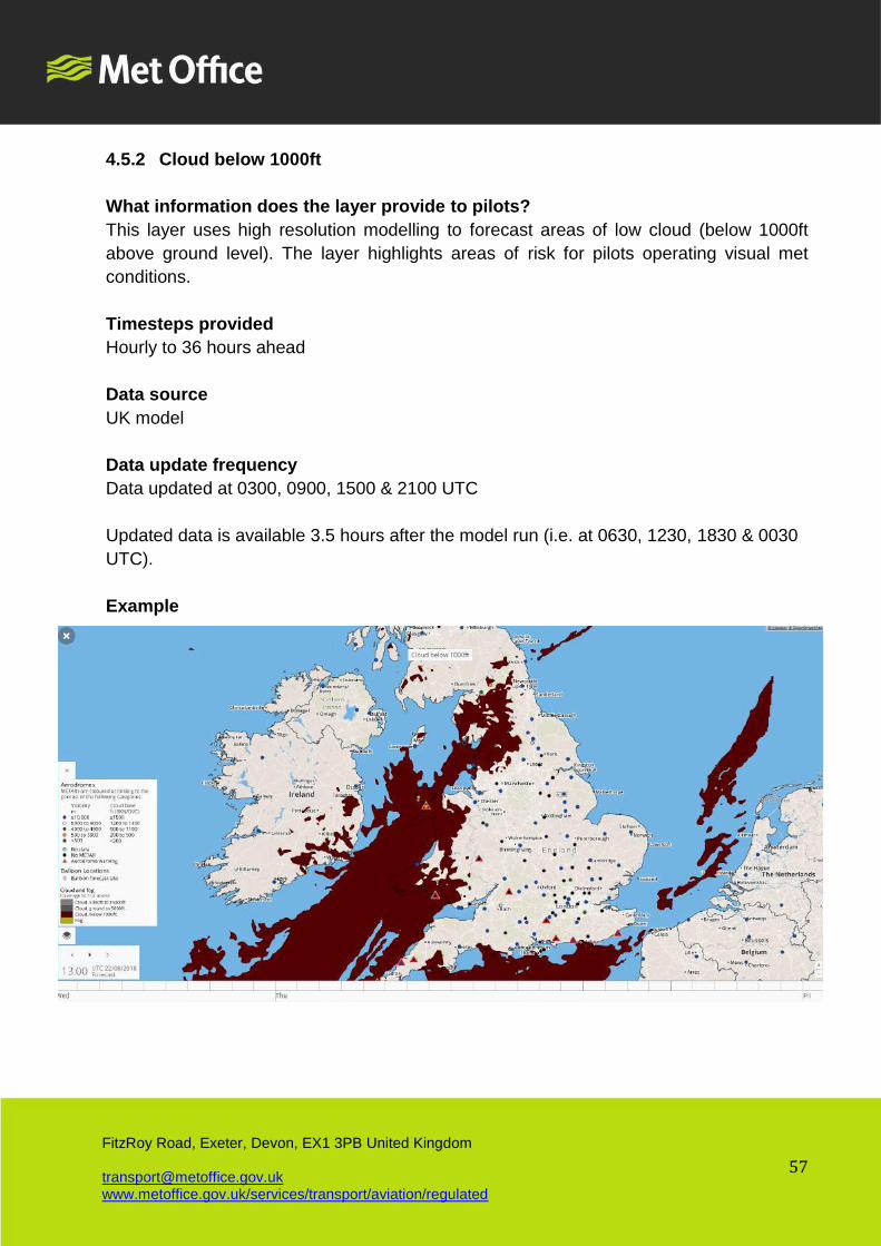
4.5.2 Cloud below 1000ft
What information does the layer provide to pilots?
This layer uses high resolution modelling to forecast areas of low cloud (below 1000ft
above ground level). The layer highlights areas of risk for pilots operating visual met
conditions.
Timesteps provided
Hourly to 36 hours ahead
Data source
UK model
Data update frequency
Data updated at 0300, 0900, 1500 & 2100 UTC
Updated data is available 3.5 hours after the model run (i.e. at 0630, 1230, 1830 & 0030
UTC).
Example
Page 58
58
FitzRoy Road, Exeter, Devon, EX1 3PB United Kingdom [email protected] www.metoffice.gov.uk/services/transport/aviation/regulated
4.5.3 Cloud Ground to 5000ft
What information does the layer provide to pilots?
This layer uses high resolution modelling to forecast areas of cloud (below 5000ft above
ground level).
Timesteps provided
Hourly to 36 hours ahead
Data source
UK model
Data update frequency
Data updated at 0300, 0900, 1500 & 2100 UTC
Updated data is available 3.5 hours after the model run (i.e. at 0630, 1230, 1830 & 0030
UTC).
Example
Page 59
59
FitzRoy Road, Exeter, Devon, EX1 3PB United Kingdom [email protected] www.metoffice.gov.uk/services/transport/aviation/regulated
4.5.4 Cloud 5000ft to 15000ft
What information does the layer provide to pilots?
This layer uses high resolution modelling to forecast areas of high cloud (above 5000ft
above ground level).
Timesteps provided
Hourly to 36 hours ahead
Data source
UK model
Data update frequency
Data updated at 0300, 0900, 1500 & 2100 UTC
Updated data is available 3.5 hours after the model run (i.e. at 0630, 1230, 1830 & 0030
UTC).
Example
Page 60
60
FitzRoy Road, Exeter, Devon, EX1 3PB United Kingdom [email protected] www.metoffice.gov.uk/services/transport/aviation/regulated
4.5.5 Visibility & Pressure
What information does the layer provide to pilots?
This layer uses high resolution modelling to forecast areas of potential low visibility and
associated pressure pattern. Areas of low visibility are normally associated with frontal
systems, heavy precipitation or low cloud.
Timesteps provided
Hourly to 36 hours ahead
Data source
UK model
Data update frequency
Data updated at 0300, 0900, 1500 & 2100 UTC
Updated data is available 3.5 hours after the model run (i.e. at 0630, 1230, 1830 & 0030
UTC).
Example
Page 61
61
FitzRoy Road, Exeter, Devon, EX1 3PB United Kingdom [email protected] www.metoffice.gov.uk/services/transport/aviation/regulated
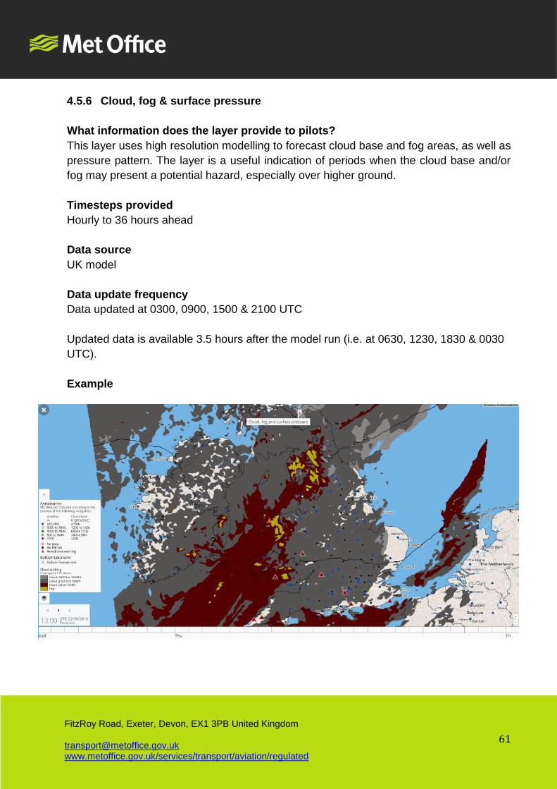
4.5.6 Cloud, fog & surface pressure
What information does the layer provide to pilots?
This layer uses high resolution modelling to forecast cloud base and fog areas, as well as
pressure pattern. The layer is a useful indication of periods when the cloud base and/or
fog may present a potential hazard, especially over higher ground.
Timesteps provided
Hourly to 36 hours ahead
Data source
UK model
Data update frequency
Data updated at 0300, 0900, 1500 & 2100 UTC
Updated data is available 3.5 hours after the model run (i.e. at 0630, 1230, 1830 & 0030
UTC).
Example
Page 62
62
FitzRoy Road, Exeter, Devon, EX1 3PB United Kingdom [email protected] www.metoffice.gov.uk/services/transport/aviation/regulated
4.6 Euro Forecast – Premium subscribers only
4.6.1 Precipitation Rate & Pressure
What information does the layer provide to pilots?
This layer forecasts the movement and intensity of precipitation, and associated pressure
pattern over the wider European area.
This layer is useful for pilots flying from the UK to parts of Europe.
Timesteps provided
Hourly to 36 hours ahead
Data source
EURO model
Data update frequency
Data updated at 0300, 0900, 1500 & 2100 UTC
Updated data is available 4.5 hours after the model run (i.e. at 0730, 1330, 1930 & 0130
UTC).
Example
Page 63
63
FitzRoy Road, Exeter, Devon, EX1 3PB United Kingdom [email protected] www.metoffice.gov.uk/services/transport/aviation/regulated
4.6.2 Precipitation Type & Pressure
What information does the layer provide to pilots?
This layer forecasts the movement and type of precipitation, and associated pressure
pattern over the wider European area.
This layer is useful for pilots flying from the UK to parts of Europe.
Timesteps provided
Hourly to 36 hours ahead
Data source
EURO model
Data update frequency
Data updated at 0300, 0900, 1500 & 2100 UTC
Updated data is available 4.5 hours after the model run (i.e. at 0730, 1330, 1930 & 0130
UTC).
Example
Page 64
64
FitzRoy Road, Exeter, Devon, EX1 3PB United Kingdom [email protected] www.metoffice.gov.uk/services/transport/aviation/regulated
4.6.3 Visibility & Pressure
What information does the layer provide to pilots?
This layer forecasts areas of potential low visibility and associated pressure pattern over
the wider European area. Areas of low visibility are normally associated with frontal
systems, heavy precipitation or low cloud.
This layer is useful for pilots flying from the UK to parts of Europe.
Timesteps provided
Hourly to 36 hours ahead
Data source
EURO model
Data update frequency
Data updated at 0300, 0900, 1500 & 2100 UTC
Updated data is available 4.5 hours after the model run (i.e. at 0730, 1330, 1930 & 0130
UTC).
Example
Page 65
65
FitzRoy Road, Exeter, Devon, EX1 3PB United Kingdom [email protected] www.metoffice.gov.uk/services/transport/aviation/regulated
4.6.4 Total Cloud & Pressure
What information does the layer provide to pilots?
This layer forecasts cloud coverage and associated pressure pattern over the wider
European area.
Timesteps provided
Hourly to 36 hours ahead
Data source
EURO model
Data update frequency
Data updated at 0300, 0900, 1500 & 2100 UTC
Updated data is available 4.5 hours after the model run (i.e. at 0730, 1330, 1930 & 0130
UTC).
Example
Page 66
66
FitzRoy Road, Exeter, Devon, EX1 3PB United Kingdom [email protected] www.metoffice.gov.uk/services/transport/aviation/regulated
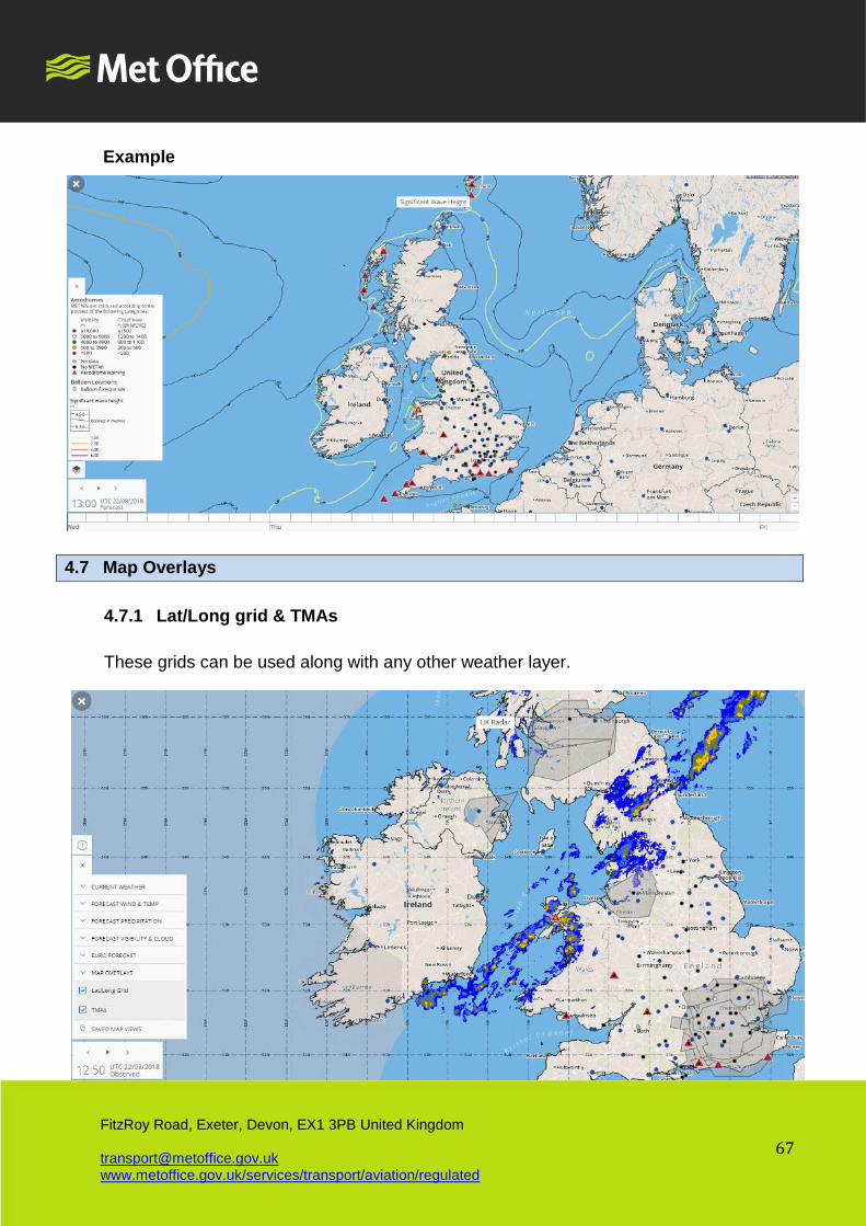
4.6.5 Significant Wave Height
What information does the layer provide to pilots?
This layer presents the forecast wave heights around the UK. Bands of equal wave
height are shown. Through using the forecast sequence, it is possible to identify periods
over the following 5 days when, for example, the wave heights are expected to increase.
Timesteps are presented:
CAP1145 describes the regulations for helicopters operating offshore, including the
requirement to brief on the sea state from an approved source such as the Met
Office. Under these regulations helicopter operations should not take place over open
seas when a wave height of 6 metres or more is expected.
The Significant wave heights provided are defined as the 'average height of the
highest one-third of waves observed' - a standard parameter used by scientists and
mariners alike. As a rough rule of thumb the 1/1000th wave experienced will be
approximately twice the significant wave height.
Timesteps provided
Hourly to 36 hours ahead.
Data source
EURO wave model
Date update frequency
4 times a day at around 0100, 0700, 1300 & 1900 UTC. Due to processing and QC there
is a period of about 4 hours between the times of the model updates and when the
updates occur on the website.
This means that the SWH product will update at around 0500, 1100 1700, 2300 UTC.
Page 67
67
FitzRoy Road, Exeter, Devon, EX1 3PB United Kingdom [email protected] www.metoffice.gov.uk/services/transport/aviation/regulated
Example
4.7 Map Overlays
4.7.1 Lat/Long grid & TMAs
These grids can be used along with any other weather layer.
Page 68
68
FitzRoy Road, Exeter, Devon, EX1 3PB United Kingdom [email protected] www.metoffice.gov.uk/services/transport/aviation/regulated
4.8 Saved Map Views
For convenience it is possible to name and save the map position you are currently viewing,
using the Saved Map Views function.
-END-