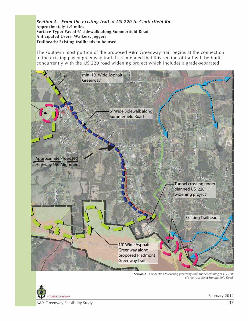
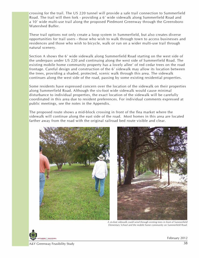
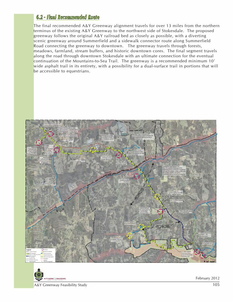
A&Y Greenway Feasibility Study from its northern terminus on the west side of US 220 northwest to the Guilford County line - through Summerfield and Stokesdale A joint planning effort by the Towns of Summerfield and Stokesdale, Guilford County, and the Greensboro Urban Area Metropolitan Planning Organization
Transcript
A&Y Greenway Feasibility Study from its northern terminus on the west side of US 220 northwest to the Guilford County line - through Summerfield and Stokesdale
A joint planning effort by the Towns of Summerfield and Stokesdale, Guilford County, and the Greensboro Urban Area Metropolitan Planning Organization
i.November 2011
A&Y Greenway Feasibility Study
ii.
November 2011
A&Y Greenway Feasibility Study
Greensboro Department of Transportation, Greensboro Urban Area Metropolitan Planning Organization (GUAMPO)
Guilford County City of GreensboroTown of StokesdaleTown of SummerfieldState of North Carolina, Department of Environment and Natural Resources (NCDENR)Summerfield Parks & Recreation Committee (SPARC)Revitalizing our Ancestors’ Dreams in Stokesdale (ROADS)Stokesdale Trails, Paths and Right of Way Committee (STPRC)
Steering Committee:Alex Ashton (Open Space Planner, Guilford County Parks & Open Space)Carrie Banks (Executive Director, NC Rails to Trails)Roger Bardsley (Parks Planner, Guilford County Parks & Open Space)Sue Beeson (Summerfield)Michael Brandt (Summerfield Town Manager)Harry Clapp (NC Rails to Trails)Kate Dixon (Executive Director, Friends of the Mountains-to-Sea Trail)Jean-Yves Fichou (SPARC)Mickie Halbrook (Stokesdale Town Council member)Conrad Hayter (SPARC)Peggy Holland (Bicycle and Pedestrian Coordinator, Greensboro DOT, GUAMPO)Helen Isley (STPRC)Sherrie Joseph (Summerfield Parks & Recreation Committee)Carolyn Joyner (Stokesdale Town Clerk)Scott Lawrence (STPRC)Pam Lemmons (ROADS)Darrell McBane (State Trails Program Manager, NCDENR)Mike Simpson (Director of Trails and Greenways, Greensboro Parks & Recreation Deptartment)Kevin Redding (Piedmont Land Conservancy)
Special thanks to the citizens and businesses in Summerfield and Stokesdale for their support
and guidance throughout the planning process.
ACKNOWLEDGEMENTS
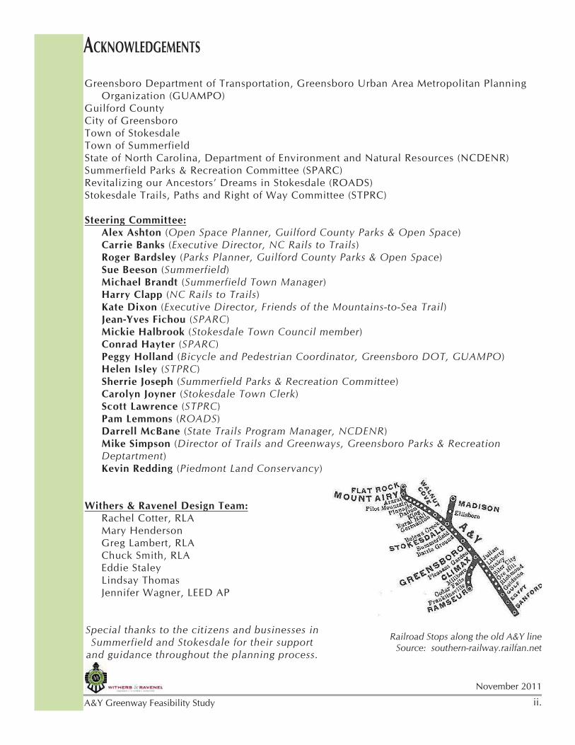
Railroad Stops along the old A&Y lineSource: southern-railway.railfan.net
November 2011
A&Y Greenway Feasibility Study iii.
November 2011
A&Y Greenway Feasibility Study iv.
TABLE OF CONTENTSAcknowledgements ............................................................................... 3Chapter One - Executive Summary .......................................................... 1
1.1 - Overview ........................................................................................... 11.2 - Vision Statement and Goals ................................................................ 21.3 - Study Recommendations ...................................................................... 3
Chapter Two - Site Documentation & Analysis ......................................... 62.1 - Site Documentation ............................................................................ 62.2 - Findings ............................................................................................. 92.3 - History ............................................................................................. 112.4 - Site Analysis ..................................................................................... 122.5 - Precedent Studies .............................................................................. 15
Chapter Three - Public Input Process .................................................... 213.1 - Steering Committee ........................................................................... 213.2 - Public Workshops ............................................................................. 223.3 - Public Education ............................................................................... 233.4 - Public Meeting Results ...................................................................... 253.5 - Census Data ..................................................................................... 253.6 - Survey .............................................................................................. 263.7 - Additional Public Input ..................................................................... 29
Chapter Six - Conclusion ................................................................... 1046.1 - Action Plan .................................................................................... 1046.2 - Final Recommended Route .............................................................. 1056.3 - Conclusion/Summary ....................................................................... 106
Appendix .......................................................................................... 107A.1 - Public Meetings and Exhibits ........................................................... 107A.2 - Meeting Minutes and Sign In Sheets ................................................. 124A.3 - Public Survey Results ...................................................................... 144A.4 - Previous Planning Efforts and Related Studies ................................... 166
1
February 2012
A&Y Greenway Feasibility Study
1.1 - OverviewThe A&Y Greenway Feasibility Study was initiated and funded by the Greensboro Urban Area Metropolitan Planning Organization (GUAMPO). The study area includes an approximately 12 mile segment of the abandoned Atlantic & Yadkin (A&Y) railroad bed that runs through the Guilford County towns of Summerfield and Stokesdale. Previous area greenway, pedestrian, and bicycle planning efforts and documents identify the A&Y corridor for future trail development.
While serving area residents of Summerfield and Stokesdale, this corridor also provides important opportunities for regional connectivity. Not only does it connect with the Greensboro Greenway System to the south, but future development of the Piedmont Greenway and Mountains-to-Sea Trail are also located within the study area. When constructed, it is intended that the A&Y Greenway will be designated as part of the Mountains-to-Sea Trail.
The benefits of greenways as a valued community amenity are well documented in studies conducted across the country. In virtually every citizen survey conducted by communities for recreation comprehensive planning, walking as an activity and trail and greenway facility development top the citizen priority list for community recreation. Greenways, often described as “linear parks”, can be enjoyed by every segment of the population. As obesity has risen to the level of a national health crisis, the proximity of greenways to residents impacts the basic opportunity for increased physical activity for a generally sedentary population. Greenway and open space corridor protection addresses environmental concerns by protecting sensitive areas from development, improving storm water management, preserving wildlife and native species habitat, and creating alternative transportation systems. As an integral part of a community’s quality of life and livability, attractive to both residents and businesses, greenways impact the economic viability of cities and towns. Many communities have opted to promote trails as tourist attractions, generating spending and contributing to economic growth.
The A&Y Greenway Feasibility Study recommendations were influenced not only by national literature and precedent studies, but also by the local community characteristics and opinions specific to the study
CHAPTER ONE - EXECUTIVE SUMMARY
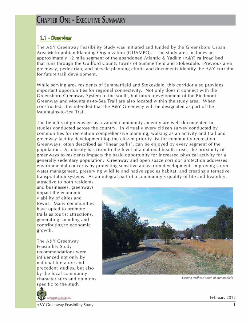
Existing trailhead south of Summerfield
2February 2012
A&Y Greenway Feasibility Study
area. Physical attributes, technical data, field observations, and public input gathered and analyzed by the Design Team drove trail alignment and concept recommendations. A Steering Committee of town officials and interested parties guided the process and resident opinions were captured in public workshops and the implementation of a survey tool.
As evidenced by the workshops and surveys, there exists a high level of interest in and support for the development of the A&Y Greenway in both Summerfield and Stokesdale. Approximately 75% of survey respondents considered the A&Y Greenway important to both them and their community. Mirroring national trail user data, the survey found, in priority order, walkers and bikers as the top two user groups. Workshop attendees expressed immediate desires to walk and bike the trail, questioning the anticipated completion time. Equestrian interests also surfaced in both the surveys and public workshops. The prominence of horse owners and farms in this area of Guilford County has significant implications for trail development. A 2007 study, conducted by The Rural Center of North Carolina, revealed Guilford County as second only to Union County in the total inventory of equine in North Carolina.
Active from 1899 to 1950 with a depot located in each town, the A&Y railroad holds both cultural and historic significance to Summerfield and Stokesdale. In light of this context, it was important to locate the trail on the original railroad location to the extent possible. Over time, with the abandonment of the railroad corridor and the conversion of ownership to adjacent property owners, portions of the original bed have been obscured by development and in some instances, the railroad bed is in very close proximity to roads and buildings. In other areas the railway bed remains visible and creates an ideal trail location. Officials from both Summerfield and Stokesdale expressed the desire for the A&Y Greenway to go through their downtown areas.
1.2 - Vision Statement and GoalsVision Statement - To develop a trail plan and alignment that will be the foundation for a connected regional alternative transportation system and recreation amenity, enhancing quality of life by connecting people to nature, supporting an increase in physical activity, and impacting economic development.
Goal 1:Provide a trail for all users that creates diversity of experience and meets the needs of the different users, including equestrians.
Goal 2:Provide access, safety and comfort for all user groups by identifying trailhead facilities, signage, and amenities along the trail.
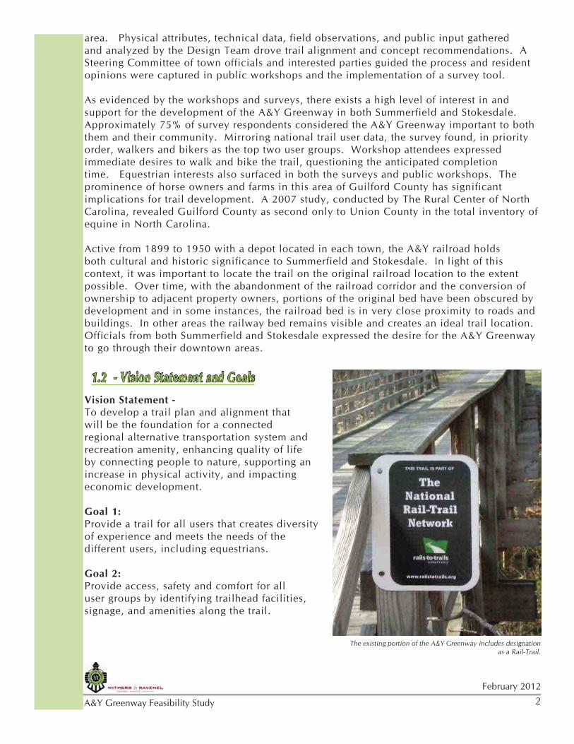
The existing portion of the A&Y Greenway includes designation as a Rail-Trail.
3
February 2012
A&Y Greenway Feasibility Study
Goal 3:Provide connectivity to community assets including neighborhoods, natural features, public parks and buildings, historic places, downtown businesses, and area regional trails.
Goal 4:Consider strategies and cost implications of plan implementation related to policies, planning, property acquisition, construction, and trail maintenance and management.
Goal 5:Create a plan that can be used for future regional planning and funding opportunities.
1.3 - Study RecommendationsIn consideration of the local community characteristics and opinions coupled with best greenway development practices for a regional recreation amenity and transportation system, the trail alignment was guided by the following criteria:
•Location of the original A&Y railway•Variety of trail user groups •Diversity of the trail experience or “feel” •Connectivity•Existing easements•Trailhead locations •Road crossings
The final A&Y Greenway alignment recommendation is detailed in Chapter 4 of this report.
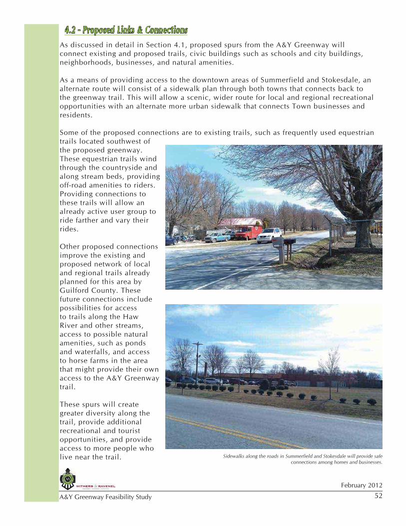
The trail remains on or very close to the original railroad bed in three sections: 1) A portion of Summerfield Road as an alternate sidewalk section (.8 mile); 2) Between and connecting Summerfield and Stokesdale crossing the original railroad trestle (3 miles); and 3) Through downtown Stokesdale near the crossing with Highway NC 68 (1 mile).
The trail alignment diverts from the original railroad bed to the west of Summerfield, creating a scenic experience in a natural setting as well as a potential opportunity for equestrian use. In Stokesdale the trail meanders away from the
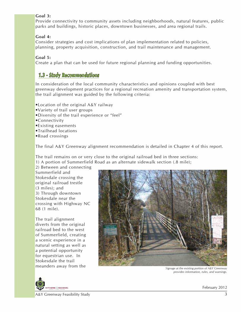
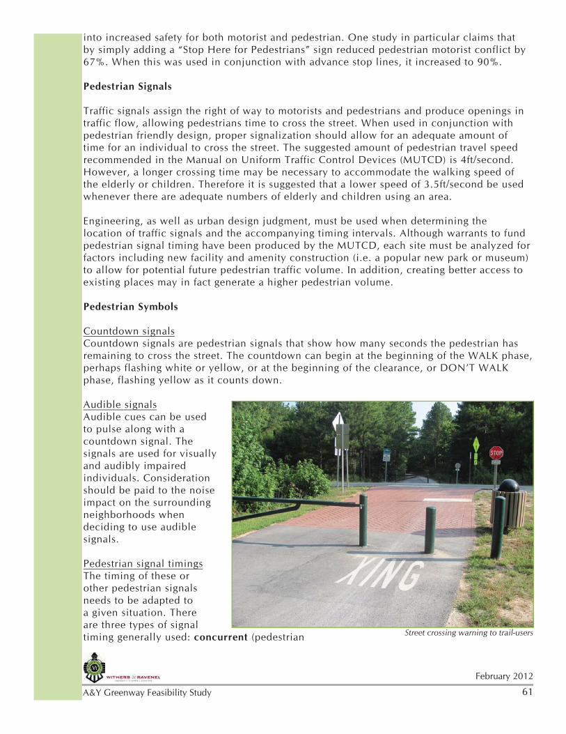
Signage at the existing portion of A&Y Greenway provides information, rules, and warnings.
4February 2012
A&Y Greenway Feasibility Study
traffic and industrial corridor of US 158 through pastoral farmlands, extending the possibility for equestrian trail access and connecting with residential neighborhoods.
While road crossings are minimized, the implementation of safety design standards for approaching vehicular traffic and trail users is critical. The proposed trail alignment is flexible based upon agreements with property owners and acquired easements. Specific features encountered during the design development phase may also result in trail alignment adjustments.
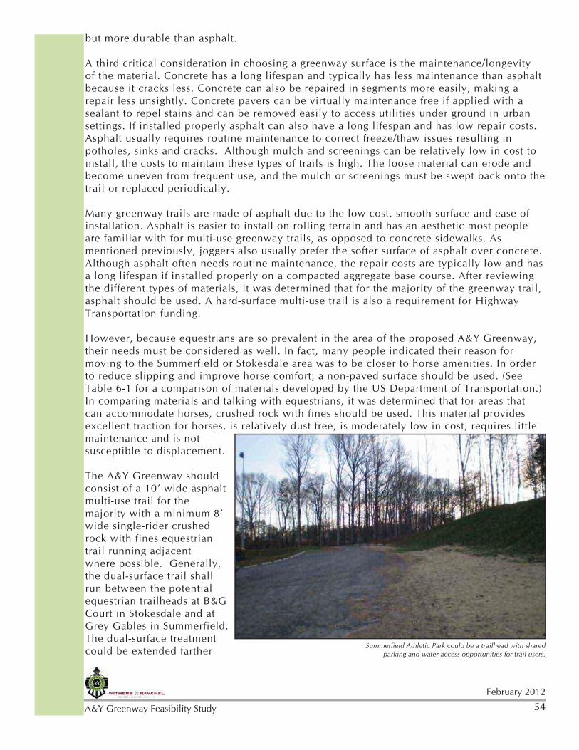
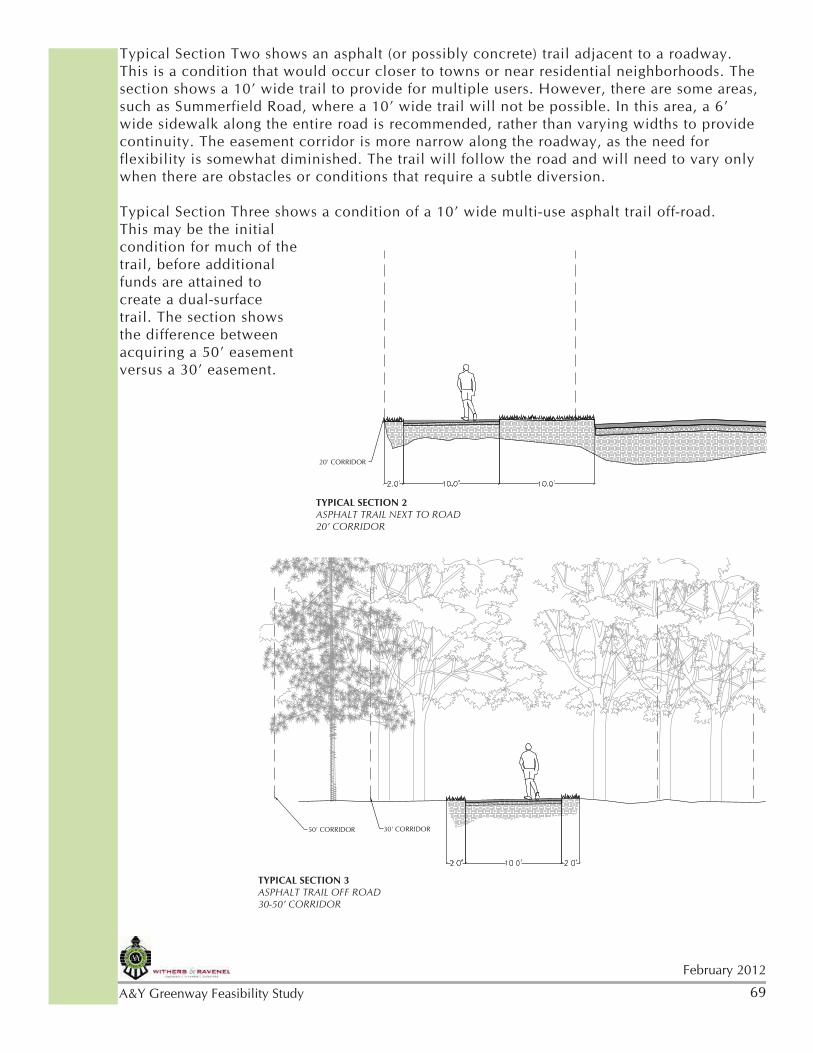
The A&Y Greenway is recommended as a 10’ wide asphalt multi use trail with a dual, or adjacent, 8’ wide hard-packed gravel surface in areas that are also designated for equestrian use. The alternate sidewalk route along Summerfield Road is recommended to be a 6’ wide asphalt or concrete surface. National greenway design standards (AASHTO) call for 10’ to 12’ widths for shared use trails with concrete or asphalt surfaces. The trail width impacts the ability for both pedestrians and cyclists to safely travel with two-way traffic. A paved surface requires less maintenance, is more stable for seniors, more amenable for strollers, rollerblades or skates, and is also required to access transportation funding.
There are a variety of opinions, sources, and precedents for equestrian trail width standards, but typically 6’ minimum for a dual surface trail and up to 12’ for two way horse traffic are used. Some horse trails are built as single tract paths which may include very little upgraded surfacing. In order to accommodate the addition of equestrian use, flexibility in implementation of the standard recommendation will likely be necessary in some cases. For example, there may be some instances where the dual surface within a designated equestrian section may not be possible due to the topography or other land related issue. In this case, a single tract natural surface that meanders away from the 10’ paved surface may be more practical and functional. Maintenance considerations should be evauluated in final surfacing decisions during project implementation.
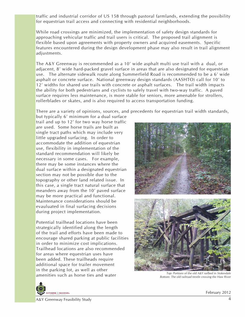
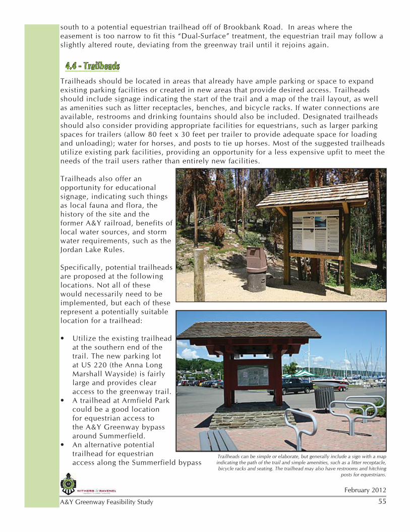
Potential trailhead locations have been strategically identified along the length of the trail and efforts have been made to encourage shared parking at public facilities in order to minimize cost implications. Trailhead locations are also recommended for areas where equestrian uses have been added. These trailheads require additional space for trailer movement in the parking lot, as well as other amenities such as horse ties and water Top: Portions of the old A&Y railbed in Stokesdale
Bottom: The old railroad trestle crossing the Haw River
5
February 2012
A&Y Greenway Feasibility Study
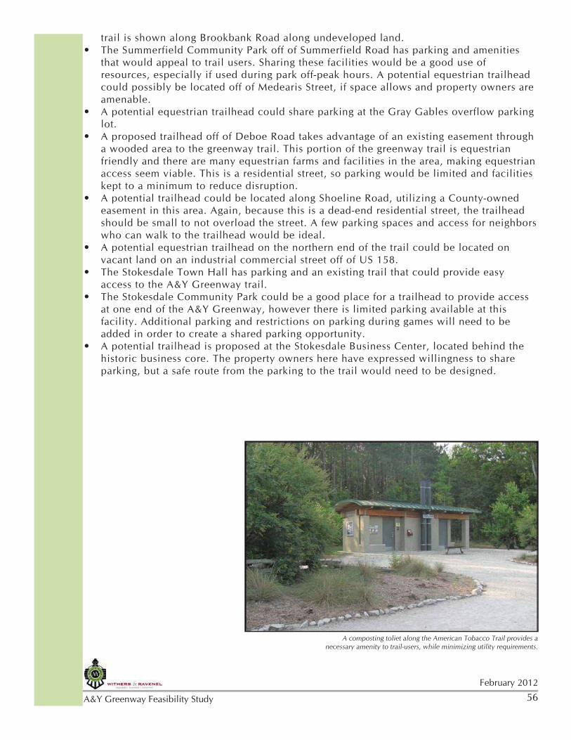
troughs. Signage for safety, rules and regulations, and wayfinding should be located at trailheads and along the trail as appropriate. Restrooms, benches, water fountains, and map kiosks enhance trail user experiences. Public art, either integrated or stand-alone, can add a special identity and focal point along a greenway, often involving community volunteers and fostering support. A detailed discussion of trail amenities and trailheads can be found in Chapter 4 of this report.
Opportunities for connectivity with regional trails, natural scenic ares, public facilities, neighborhoods, businesses, and local equestrian trail spurs influenced the recommended trail alignment. The ability to create loops connecting sidewalks enhances trail use and enjoyment. As detailed in Chapter 4, the A&Y Greenway will provide a connected system linking area amenities with expanded options for trail users.
As a regional trails system, implementation and phasing of the A&Y Greenway is dependent upon the cooperative efforts of multiple jurisdictions. Rather than recommending a specific sequence of trail segment implementation that might not have a practical application, the study acknowledges that construction of the individual trail segments will verylikely occur in a haphazard manner as funding opportunities present themselves. As a result, the study recommends criteria to guide phasing decisions. These are explained in more detail in Chapter 5 and are as follows:
•Opportunity ( Highway Improvements, Land Development, Grants)•Proximity to Residents•Connectivity•Logical or Accessible Termination Points
Trail segments may develop independently and could also occur concurrently. Estimated costs required for trail implementation is included in Chapter 5. As trail corridor property is obtained and funding secured, phasing plans and timelines should be updated.
In support of the successful implementation of the A&Y Greenway, Chapter 6 identifies important Action Steps that will position the jurisdictions for success. A persistent and consistant effort among the citizens and officials of the Town of Summerfield, the Town of Stokesdale, and Guilford County along with GUAMPO and other trail partners will be required to achieve the A&Y Greenway vision, a regionally connected transportation system and recreation amenity. The ultimate goal remains a connected paved 10’ wide paved greenway with a dual surface 8’ wide hard-packed gravel surface in sections identified for equestrians but the flexibility exists to acccommodate lesser widths when site constraints present themselves.
6February 2012
A&Y Greenway Feasibility Study
2.1 - Site Documentation
The Design Team approached the study of the proposed A&Y Greenway by first gathering existing information related to the corridor that would likely influence the study recommendations. Data collection methods included document research, field observation, digital mapping, and discussions with officials and residents. This section documents existing political, physical, transportation, recreation, cultural, historic, and land use conditions.
Previous area planning efforts undertaken by the jurisdictions within the study area document and confirm the desirability for the future development of alternative transportation systems and recreation amenities, specifically the proposed A&Y Greenway. A summary of some of these planning efforts are listed in the Appendix and are presented below:
Greensboro Urban Area Bicycle, Pedestrian, and Greenway Master Plan (BiPed Plan)
The plan, approved on October 11, 2006 by the Transportation Advisory Committee of the Greensboro Urban Area Metropolitan Planning Organization, was an outgrowth of the Greensboro Urban Area 2030 Long Range Transportation Plan that found widespread support for alternative transportation systems. The BiPed Plan established a standard of greenway access within 1/2 mile of the majority of the population. A Bicycle Suitability Model used to assess the Level of Service (LOS) on roadways for bicyclists indicated low LOS ( D, E, or F) for the Summerfield and Stokesdale area, particularly US 220 and US 158. The A&Y corridor, referred to in the plan as the
CHAPTER TWO - SITE DOCUMENTATION & ANALYSIS
220
Liitle Loop Trail
Liitle Loop Trail
Big Loop Trail
Big Loop Trail
Piedmont TrailPiedmont Trail
Palm
etto T
rail
Palm
etto T
rail
Wild Turke
y Trai
l
Wild Turke
y Trai
l
Nat Greene Trail
Nat Greene Trail
Owl’s Roost Trail
Owl’s Roost Trail
Bicentennial Greenway
Bicentennial Greenway
Laurel Bluff TrailLaurel Bluff Trail
Reedy Fork TrailReedy Fork Trail
Atlantic & Yadkin Greenway
Atlantic & Yadkin Greenway
OWLS ROOST RD
LAKE
BRAN
DT RD
AIR HARBOR RD
PISGAH CHURCH RD
HORSEPEN CREEK RD OLD BATTLEGROUND AVE
LAWNDALE DR
NEW GARDEN RD
BATTLEGROUND AVE
CONE
BLVD
JOSEPH M BRYAN BLVD
WES
TRID
GE R
D
HOLDEN RD
Lake Brandt
Bur-MilPark
Bur-MilPark
CountryPark
CountryPark
Guilford CourthouseNational Military
Park
Guilford CourthouseNational Military
Park
NaturalScience Center
NaturalScience Center
CarolynAllenPark
CarolynAllenPark
Fire L
anes
Fire L
anes
STRA
WBERR
Y RD
CONE BLVD
Forest LawnCemetery
Forest LawnCemetery
Lake BrandtMarina
Lake BrandtMarina
Atlantic & Yadkin Greenway - 7.5 miles
LegendParks
Parking
Lakes
Multi-Use Trails
Hiking Only Trails
Streets
Rivers
Gree
nsbo
ro T
rails
Sys
tem
Gree
nsbo
ro T
rails
Sys
tem
Data
Com
piled b
y the C
ity o
f G
reensboro
GIS
Div
isio
nM
ap C
reate
d b
y G
reensboro
Park
s &
Recre
ation T
rails D
ivis
ion
0 1 2 Miles
Reedy Fork Creek
Richland Cree
k
Hors
epen
Cre
ek
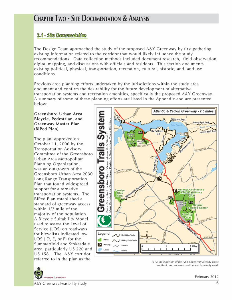
A 7.5 mile portion of the A&Y Greenway already exists south of this proposed portion and is heavily used.
7
February 2012
A&Y Greenway Feasibility Study
Summerfield-Stokesdale Rail Trail, was recommended for greenway development.
Summerfield Comprehensive Plan. Our Plan. Our Town. Policy Area #2 Sidewalk, Bikeway, and Trails
Adopted May 11, 2010, the plan establishes Common Objectives, Policies, and Actions that support sidewalk, bikeway and trail development. Specifically, the Town “strives to become a walkable and bikeable community.” The plan emphasizes connectivity and commits to coordinated regional efforts with the Greensboro Urban Area MPO. The plan calls for protecting the A&Y railbed for greenway development and recognizes the opportunities for the Mountains-to-Sea Trail and Piedmont Greenway. Additionally, the plan indicates the need to plan for equestrian trails.
Stokesdale Future Land Use Plan (2007)
The Stokesdale Future Land use Plan map depicts the A&Y railbed as a future trail. A portion of the vision statement reads as follows: “The Town should promote alternative modes of transportation, including pedestrian, bicycle, and equestrian movement throughout the community.”
The Design Team also analyzed connections and shared efforts with the Piedmont Greenway and the Mountains-to-Sea Trail by reviewing the Piedmont Greenway Feasibility Study and coordinating with the State Trails Program within the N.C. Division of Parks and Recreation.
In addition to comprehensive community planning efforts, the Design Team reviewed future NC Department of Transportation plans for road enhancement and development projects within the study area. While road projects may be viewed as an impediment to trail development, coordinating trail development with road construction often creates an opportunity for shared costs. It is also important to note that NCDOT coordinates roadway projects with greenways in adopted plans. Future road projects impacting the corridor include:
• US 220 widening near Summerfield Road• I-73 south of Haw River• US 158 realignment near Stokesdale• NC 150 proposed realignment in Summerfield
Following a comprehensive review of relevant planning documents, the design team initiated a physical study of the geographic area. Innovative technology utilizing GIS and Google Earth images was used to create a computerized “fly over” of the original rail corridor. This provided a conceptual view of existing topography, physical obstacles, the road network, and other conditions, allowing the design team to quickly identify potential areas of special concern.
The next step involved a more detailed compilation of site data within a larger corridor study area. This data was collected digitally and displayed on maps for more in-depth and thorough review and analysis. The following information was mapped:
• Floodplain identification (100-year and 500-year storms)• Topography
8February 2012
A&Y Greenway Feasibility Study
• Zoning• Property lines• Parcel ownership • Schools and parks• Historic and cultural sites• Public Buildings (Townhalls, Fire Stations, etc.)• Existing easements and Rights of Way• Regional trail plans• Existing and future thoroughfare plans
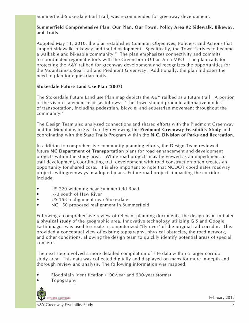
Verification of mapping conditions in specific areas of concern required Design Team site visits. These “ground truthing” excercises proved especially beneficial due to the inability to locate the abandoned railroad bed in some areas because of development. Additional site specific information was gained that aided in developing alternate trail alignments for consideration and analysis.
While the importance of technical data is obvious for feasibility study development, the relevancy and importance of information obtained from conversations with local officials and residents also influences trail development. The additional information gathered by the Design Team included the following topics:
• Cultural and historic information• Natural areas and attractions of significance to the community• Land owner opinions of granting property easements• Corridor traffic congestion and parking problems • Equestrian trail connections
Site Inventory Maps show flood plains, topography, zoning, parks and schools along the A&Y railbed
9
February 2012
A&Y Greenway Feasibility Study
2.2 - FindingsThe A&Y Railroad was officially dissolved on January 26, 1950. However, rail traffic continued to operate between Greensboro and Mount Airy as part of the Southern Railway until the mid-1980’s. After this, portions of the track were abandoned or sold.
In the project study area, all of the tracks from the old A&Y railroad have been removed but the railroad bed is still visible in many places, particularly in the undeveloped countryside. However, in both Stokesdale and Summerfield the railroad bed is more difficult to locate and in some instances buildings and access drives have actually been constructed on top of the alignment. The railroad right-of-way has not been maintained, and in most areas, has been deeded to the adjacent property owners, resulting in limited or non-existent easement opportunities. This existing condition, unlike rail trail projects with intact rail corridors, presents challenges requiring flexibility and creativity in greenway alignment and implementation.
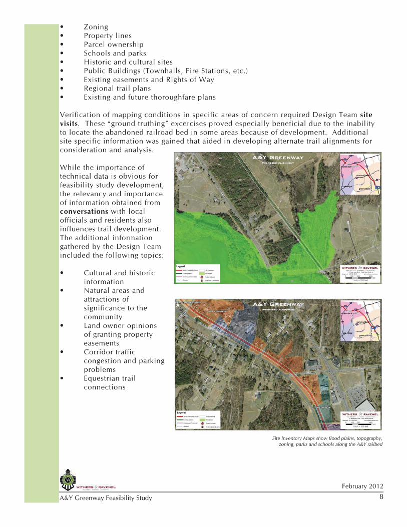
Zoning and land use information revealed that several easements have already been acquired along the railroad bed. Summerfield, Stokesdale and Guilford County have attempted to set aside additional easements along the original railroad bed to facilitate future implementation and to take advantage of area amenities. A sampling of these easements include:
• An easement providing access from Deboe Road to the railbed.• Easements along the old railbed north of the Haw River.• An easement providing access from Shoeline Road to the railbed.• Easements located on the old railbed behind businesses along US 158.
The following community assets and on-going projects that augment trail Aerial Maps with photos taken of existing conditions
along the A&Y railbed
10February 2012
A&Y Greenway Feasibility Study
development and opportunities for connectivity have been identified within the study area:
• Two community parks in Summerfield• Two community parks in Stokesdale• Summerfield Elementary School• Stokesdale Elementary School
Bruce Park (DAR memorial) in Summerfield• Stokesdale Historic District• Summerfield Historic District•
• Initial A&Y Greenway trail development, a 7.5 mile connecting trail and trailhead southeast of Summerfield • Existing old railroad trestle traversing the Haw River• Oak Ridge Road bridge provides a grade separated crossing• I-73 road project will provide a grade-separated crossing for the greenway.• Road widening project along US 220 will include a tunnel for a grade separated crossing.• Several natural amenities near the railroad bed: pond, waterfalls, pasture land• Many neighborhoods and businesses in close proximity
Numerous horse farms in close proximity• • Downtowns of both Summerfield and Stokesdale are in close proximity, including their respective Town Halls• Gray Gables, a historic house and attraction in Summerfield in close proximity to the railroad bed also provides a possible location for shared parking• Shared parking opportunities with the community parks and Town Halls.• Regional trail systems planned within the study area, including the Mountains-to-Sea Trail and Piedmont Greenway, provide opportunities for significant connections.
11
February 2012
A&Y Greenway Feasibility Study
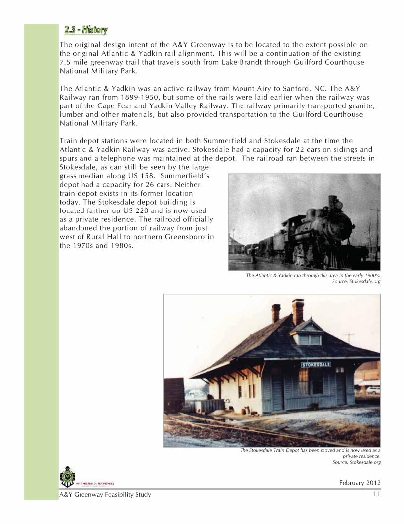
2.3 - HistoryThe original design intent of the A&Y Greenway is to be located to the extent possible on the original Atlantic & Yadkin rail alignment. This will be a continuation of the existing 7.5 mile greenway trail that travels south from Lake Brandt through Guilford Courthouse National Military Park.
The Atlantic & Yadkin was an active railway from Mount Airy to Sanford, NC. The A&Y Railway ran from 1899-1950, but some of the rails were laid earlier when the railway was part of the Cape Fear and Yadkin Valley Railway. The railway primarily transported granite, lumber and other materials, but also provided transportation to the Guilford Courthouse National Military Park.
Train depot stations were located in both Summerfield and Stokesdale at the time the Atlantic & Yadkin Railway was active. Stokesdale had a capacity for 22 cars on sidings and spurs and a telephone was maintained at the depot. The railroad ran between the streets in Stokesdale, as can still be seen by the large grass median along US 158. Summerfield’s depot had a capacity for 26 cars. Neither train depot exists in its former location today. The Stokesdale depot building is located farther up US 220 and is now used as a private residence. The railroad officially abandoned the portion of railway from just west of Rural Hall to northern Greensboro in the 1970s and 1980s.
The Stokesdale Train Depot has been moved and is now used as a private residence.
Source: Stokesdale.org
The Atlantic & Yadkin ran through this area in the early 1900’s.Source: Stokesdale.org
12February 2012
A&Y Greenway Feasibility Study
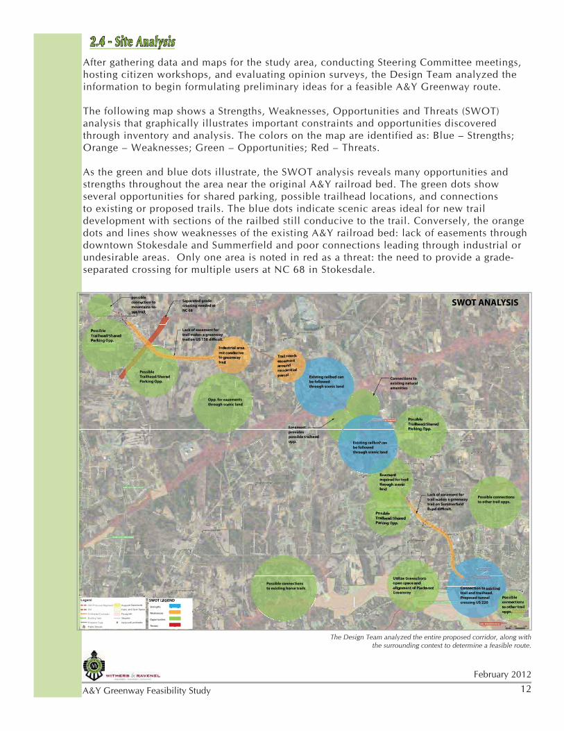
2.4 - Site AnalysisAfter gathering data and maps for the study area, conducting Steering Committee meetings, hosting citizen workshops, and evaluating opinion surveys, the Design Team analyzed the information to begin formulating preliminary ideas for a feasible A&Y Greenway route.
The following map shows a Strengths, Weaknesses, Opportunities and Threats (SWOT) analysis that graphically illustrates important constraints and opportunities discovered through inventory and analysis. The colors on the map are identified as: Blue – Strengths; Orange – Weaknesses; Green – Opportunities; Red – Threats.
As the green and blue dots illustrate, the SWOT analysis reveals many opportunities and strengths throughout the area near the original A&Y railroad bed. The green dots show several opportunities for shared parking, possible trailhead locations, and connections to existing or proposed trails. The blue dots indicate scenic areas ideal for new trail development with sections of the railbed still conducive to the trail. Conversely, the orange dots and lines show weaknesses of the existing A&Y railroad bed: lack of easements through downtown Stokesdale and Summerfield and poor connections leading through industrial or undesirable areas. Only one area is noted in red as a threat: the need to provide a grade-separated crossing for multiple users at NC 68 in Stokesdale.
ER OPEN
SPAPP CE
DDRR
RRDD
TTTTAATTTT
HC
HCCC
HC
H
CACA
DDRR
YYEE
MMLLNN
SSE
DRDR
CCTT
¯̄ SWOT ANALYSIS
EN SPACPP E
AANNGG
RRIEEDDRR
Possible
Trailhead/Shared
Parking Opp.
Possible
Trailhead/Shared
Parking Opp.
Possible
Trailhead/Shared
Parking Opp.
Opp. for easements
through scenic land
Easement
provides
possible traihead
opp.
Existing railbed can
be followed
through scenic land
Possible connections
to other trail opps.
Possible connections
to existing horse trails
Utilize Greensboro
open space and
alignment of Piedmont
GreenwayConnection to existing
trail and trailhead.
Proposed tunnel
crossing US 220
Lack of easement for
trail makes a greenway
trail on Summerfield
Road difficult.
Trail needs
easement
around
residential
parcel
Industrial area
not conducive
to greenway
trail
Lack of easement for
trail makes a greenway
trail on US 158 difficult.
Separated grade
crossing needed at
NC 68
SWOT LEGEND
Strengths
Weaknesses
Opportunities
Threats
possible
connection to
mountains-to-
sea trail
Connections to
existing natural
amenities
Proposed A &P
Possible
Trailhead/Shared
Parking Opp.
Easement
acquired for trail
through scenic
land
Existing railbed can
be followed
through scenic land
Possible
connections
to other trail
opps.
The Design Team analyzed the entire proposed corridor, along with the surrounding context to determine a feasible route.
13
February 2012
A&Y Greenway Feasibility Study
After a thorough inventory and analysis, the Design Team was able to make several key A&Y Greenway route assessments and assumptions:
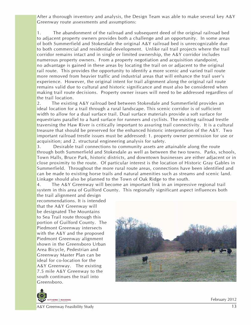
1. The abandonment of the railroad and subsequent deed of the original railroad bed to adjacent property owners provides both a challenge and an opportunity. In some areas of both Summerfield and Stokesdale the original A&Y railroad bed is unrecognizable due to both commercial and residential development. Unlike rail trail projects where the trail corridor remains intact and in single or limited ownership, the A&Y corridor includes numerous property owners. From a property negotiation and acquisition standpoint, no advantage is gained in these areas by locating the trail on or adjacent to the original rail route. This provides the opportunity to identify a more scenic and varied trail route more removed from heavier traffic and industrial areas that will enhance the trail user’s experience. However, the original intent for trail alignment along the original rail route remains valid due to cultural and historic significance and must also be considered when making trail route decisions. Property owner issues will need to be addressed regardless of the trail location.2. The existing A&Y railroad bed between Stokesdale and Summerfield provides an ideal location for a trail through a rural landscape. This scenic corridor is of sufficient width to allow for a dual surface trail. Dual surface materials provide a soft surface for equestrians parallel to a hard surface for runners and cyclists. The existing railroad trestle traversing the Haw River is critically important to assuring trail connectivity. It is a cultural treasure that should be preserved for the enhanced historic interpretation of the A&Y. Two important railroad trestle issues must be addressed: 1. property owner permission for use or acquisition; and 2. structural engineering analysis for safety. 3. Desirable trail connections to community assets are attainable along the route through both Summerfield and Stokesdale as well as between the two towns. Parks, schools, Town Halls, Bruce Park, historic districts, and downtown businesses are either adjacent or in close proximity to the route. Of particular interest is the location of Historic Gray Gables in Summerfield. Throughout the more rural route areas, connections have been identified and can be made to existing horse trails and natural amenities such as streams and scenic land. Linkage should also be planned to the Town of Oak Ridge to the south.4. The A&Y Greenway will become an important link in an impressive regional trail system in this area of Guilford County. This regionally significant aspect influences both the trail alignment and design recommendations. It is intended that the A&Y Greenway will be designated The Mountains to Sea Trail route through this portion of Guilford County. The Piedmont Greenway intersects with the A&Y and the proposed Piedmont Greenway alignment shown in the Greensboro Urban Area Bicycle, Pedestrian and Greenway Master Plan can be ideal for co-location for the A&Y Greenway. The existing 7.5 mile A&Y Greenway to the south continues the trail into Greensboro.
14February 2012
A&Y Greenway Feasibility Study
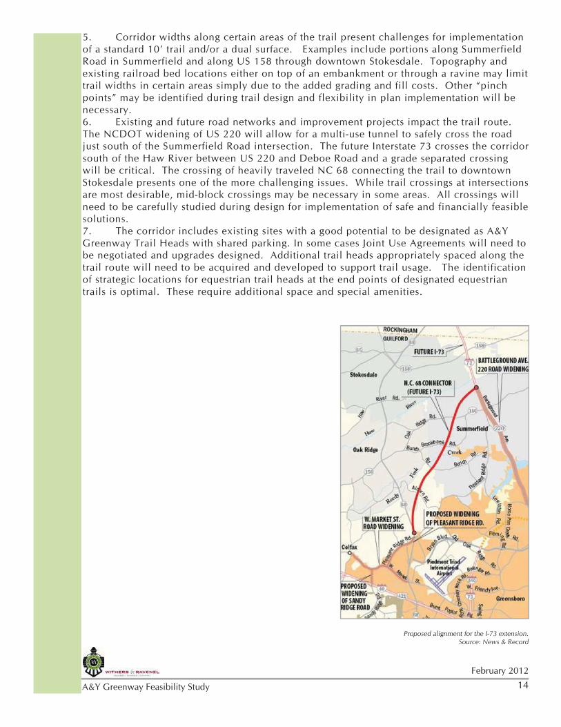
5. Corridor widths along certain areas of the trail present challenges for implementation of a standard 10’ trail and/or a dual surface. Examples include portions along Summerfield Road in Summerfield and along US 158 through downtown Stokesdale. Topography and existing railroad bed locations either on top of an embankment or through a ravine may limit trail widths in certain areas simply due to the added grading and fill costs. Other “pinch points” may be identified during trail design and flexibility in plan implementation will be necessary.6. Existing and future road networks and improvement projects impact the trail route. The NCDOT widening of US 220 will allow for a multi-use tunnel to safely cross the road just south of the Summerfield Road intersection. The future Interstate 73 crosses the corridor south of the Haw River between US 220 and Deboe Road and a grade separated crossing will be critical. The crossing of heavily traveled NC 68 connecting the trail to downtown Stokesdale presents one of the more challenging issues. While trail crossings at intersections are most desirable, mid-block crossings may be necessary in some areas. All crossings will need to be carefully studied during design for implementation of safe and financially feasible solutions. 7. The corridor includes existing sites with a good potential to be designated as A&Y Greenway Trail Heads with shared parking. In some cases Joint Use Agreements will need to be negotiated and upgrades designed. Additional trail heads appropriately spaced along the trail route will need to be acquired and developed to support trail usage. The identification of strategic locations for equestrian trail heads at the end points of designated equestrian trails is optimal. These require additional space and special amenities.
Proposed alignment for the I-73 extension. Source: News & Record
15
February 2012
A&Y Greenway Feasibility Study
2.5 - Precedent StudiesThe Design Team reviewed other greenway projects for examples of multi-use trails through or near towns that allow for equestrians. These precedents are also rails-to-trails projects. Three specific precedents were studied.
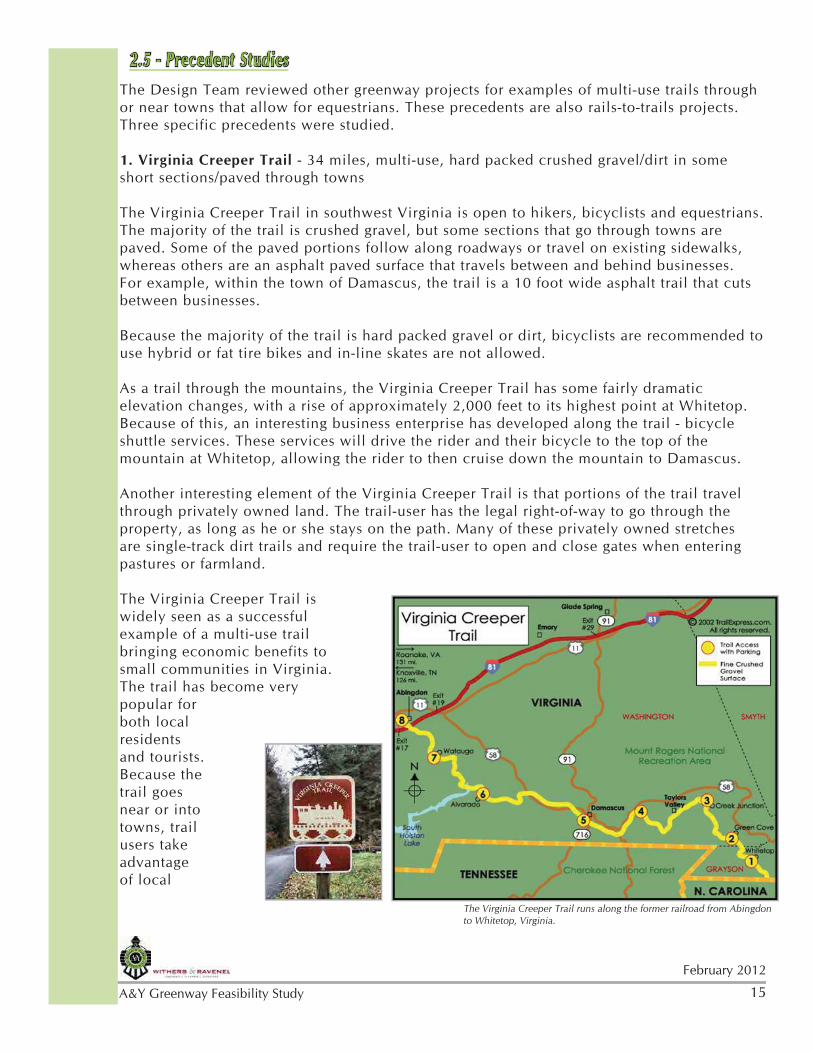
1. Virginia Creeper Trail - 34 miles, multi-use, hard packed crushed gravel/dirt in some short sections/paved through towns
The Virginia Creeper Trail in southwest Virginia is open to hikers, bicyclists and equestrians. The majority of the trail is crushed gravel, but some sections that go through towns are paved. Some of the paved portions follow along roadways or travel on existing sidewalks, whereas others are an asphalt paved surface that travels between and behind businesses. For example, within the town of Damascus, the trail is a 10 foot wide asphalt trail that cuts between businesses.
Because the majority of the trail is hard packed gravel or dirt, bicyclists are recommended to use hybrid or fat tire bikes and in-line skates are not allowed.
As a trail through the mountains, the Virginia Creeper Trail has some fairly dramatic elevation changes, with a rise of approximately 2,000 feet to its highest point at Whitetop. Because of this, an interesting business enterprise has developed along the trail - bicycle shuttle services. These services will drive the rider and their bicycle to the top of the mountain at Whitetop, allowing the rider to then cruise down the mountain to Damascus.
Another interesting element of the Virginia Creeper Trail is that portions of the trail travel through privately owned land. The trail-user has the legal right-of-way to go through the property, as long as he or she stays on the path. Many of these privately owned stretches are single-track dirt trails and require the trail-user to open and close gates when entering pastures or farmland.
The Virginia Creeper Trail is widely seen as a successful example of a multi-use trail bringing economic benefits to small communities in Virginia. The trail has become very popular for both local residents and tourists. Because the trail goes near or into towns, trail users take advantage of local
The Virginia Creeper Trail runs along the former railroad from Abingdon to Whitetop, Virginia.
16February 2012
A&Y Greenway Feasibility Study
Top: Old railroad trestle is now used for trail-users; Bottom: The Virginia Creeper Trail has gates along the trail that must be opened and closed by users when crossing private property. Sources: farm4.Static.flickr.com; blogspot
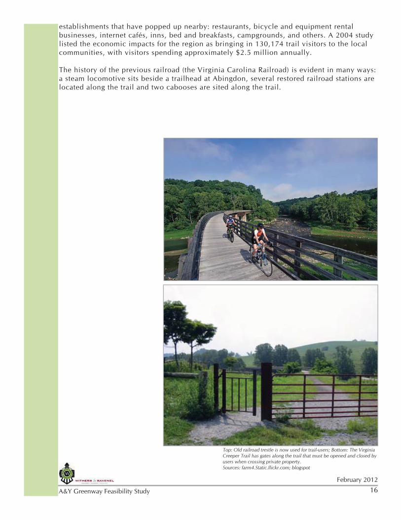
establishments that have popped up nearby: restaurants, bicycle and equipment rental businesses, internet cafés, inns, bed and breakfasts, campgrounds, and others. A 2004 study listed the economic impacts for the region as bringing in 130,174 trail visitors to the local communities, with visitors spending approximately $2.5 million annually.
The history of the previous railroad (the Virginia Carolina Railroad) is evident in many ways: a steam locomotive sits beside a trailhead at Abingdon, several restored railroad stations are located along the trail and two cabooses are sited along the trail.
17
February 2012
A&Y Greenway Feasibility Study
Photos of the Longleaf Trace Trail show the 10’ wide asphalt trail. An equestrian natural surface trail parallels approximately 26 miles of the asphalt trail.
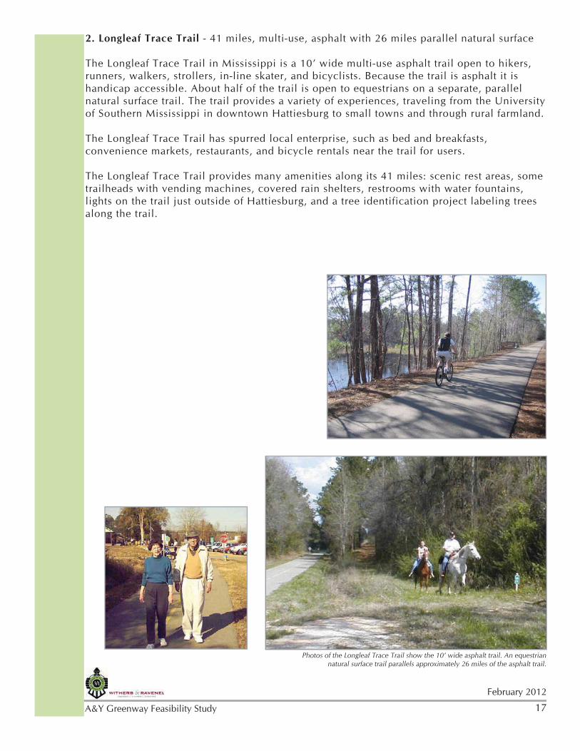
2. Longleaf Trace Trail - 41 miles, multi-use, asphalt with 26 miles parallel natural surface
The Longleaf Trace Trail in Mississippi is a 10’ wide multi-use asphalt trail open to hikers, runners, walkers, strollers, in-line skater, and bicyclists. Because the trail is asphalt it is handicap accessible. About half of the trail is open to equestrians on a separate, parallel natural surface trail. The trail provides a variety of experiences, traveling from the University of Southern Mississippi in downtown Hattiesburg to small towns and through rural farmland.
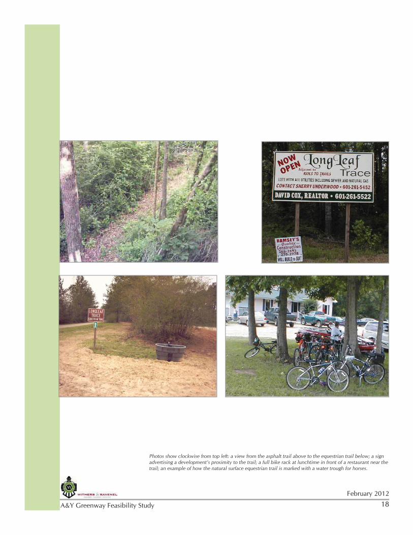
The Longleaf Trace Trail has spurred local enterprise, such as bed and breakfasts, convenience markets, restaurants, and bicycle rentals near the trail for users.
The Longleaf Trace Trail provides many amenities along its 41 miles: scenic rest areas, some trailheads with vending machines, covered rain shelters, restrooms with water fountains, lights on the trail just outside of Hattiesburg, and a tree identification project labeling trees along the trail.
18February 2012
A&Y Greenway Feasibility Study
Photos show clockwise from top left: a view from the asphalt trail above to the equestrian trail below; a sign advertising a development’s proximity to the trail; a full bike rack at lunchtime in front of a restaurant near the trail; an example of how the natural surface equestrian trail is marked with a water trough for horses.
19
February 2012
A&Y Greenway Feasibility Study
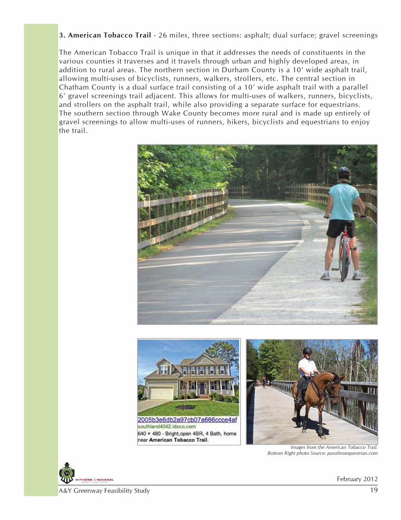
3. American Tobacco Trail - 26 miles, three sections: asphalt; dual surface; gravel screenings
The American Tobacco Trail is unique in that it addresses the needs of constituents in the various counties it traverses and it travels through urban and highly developed areas, in addition to rural areas. The northern section in Durham County is a 10’ wide asphalt trail, allowing multi-uses of bicyclists, runners, walkers, strollers, etc. The central section in Chatham County is a dual surface trail consisting of a 10’ wide asphalt trail with a parallel 6’ gravel screenings trail adjacent. This allows for multi-uses of walkers, runners, bicyclists, and strollers on the asphalt trail, while also providing a separate surface for equestrians. The southern section through Wake County becomes more rural and is made up entirely of gravel screenings to allow multi-uses of runners, hikers, bicyclists and equestrians to enjoy the trail.
Images from the American Tobacco Trail. Bottom Right photo Source: pasofinoequestrian.com
20February 2012
A&Y Greenway Feasibility Study
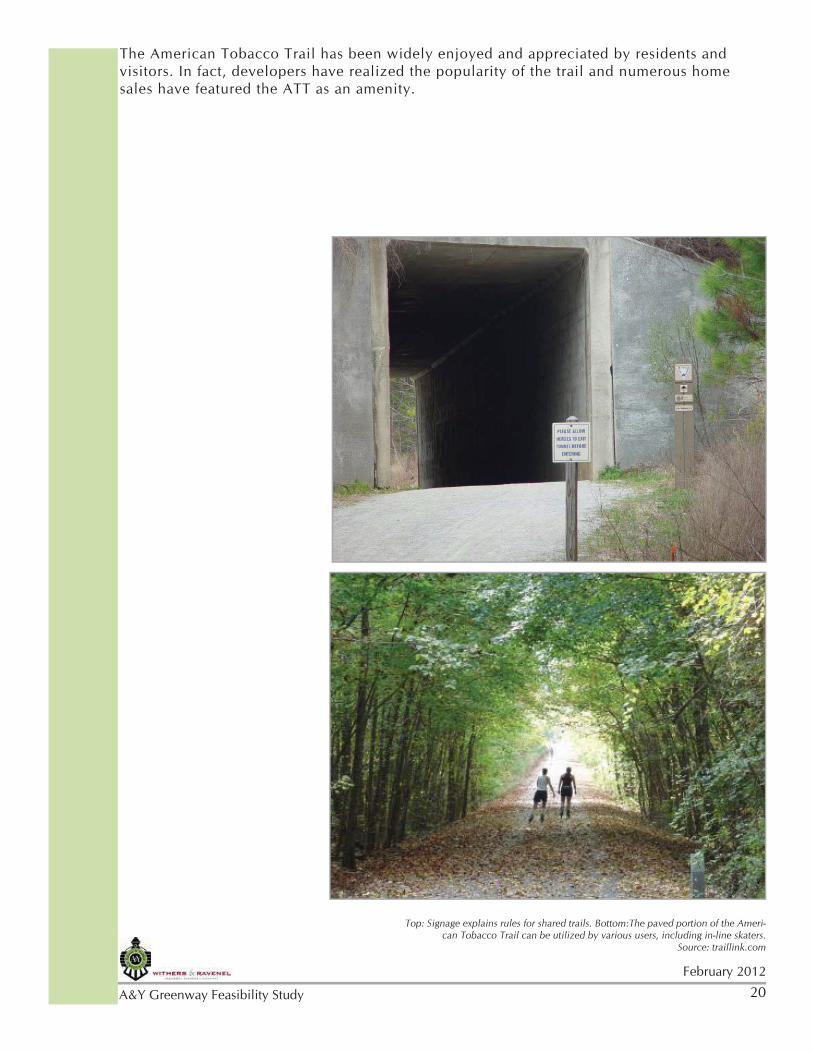
The American Tobacco Trail has been widely enjoyed and appreciated by residents and visitors. In fact, developers have realized the popularity of the trail and numerous home sales have featured the ATT as an amenity.
Top: Signage explains rules for shared trails. Bottom:The paved portion of the Ameri-can Tobacco Trail can be utilized by various users, including in-line skaters.
Source: traillink.com
21
February 2012
A&Y Greenway Feasibility Study
Public Input is an important early step in the development of a Feasibility Study. A well-designed process builds public awareness of the project and educates citizens about the benefits of trails and greenways in addition to capturing valuable community information and opinions.
The Atlantic & Yadkin Greenway Agreement was created between the Greensboro Urban Area Metropolitan Planning Organization (GUAMPO), Guilford County, the City of Greensboro, the Town of Stokesdale, the Town of Summerfield and the State of North Carolina Department of Environment and Natural Resources to create a partnership for planning and implementing a multi-use trail along the historic A&Y railroad bed from downtown Greensboro northwest through Summerfield and Stokesdale to the Guilford/Forsyth County line.
For this study, a Steering Committee was established to guide the process. A website (http://aygreenwaytrail.withersravenel.com) was created to provide project information and access for citizen input. Two primary public input methods were used: 1.) Public workshops and 2.) A survey tool. For the equestrian community, Mobile 311 GPS Technology was also available.
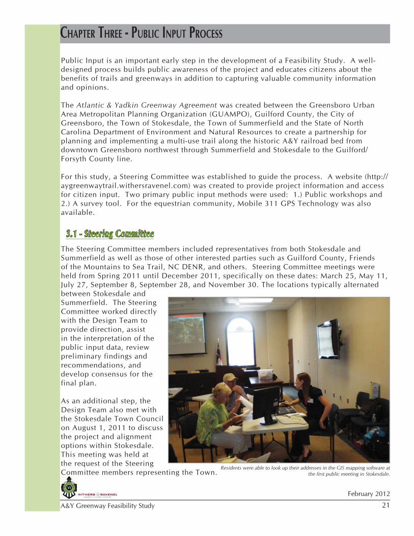
3.1 - Steering CommitteeThe Steering Committee members included representatives from both Stokesdale and Summerfield as well as those of other interested parties such as Guilford County, Friends of the Mountains to Sea Trail, NC DENR, and others. Steering Committee meetings were held from Spring 2011 until December 2011, specifically on these dates: March 25, May 11, July 27, September 8, September 28, and November 30. The locations typically alternated between Stokesdale and Summerfield. The Steering Committee worked directly with the Design Team to provide direction, assist in the interpretation of the public input data, review preliminary findings and recommendations, and develop consensus for the final plan.
As an additional step, the Design Team also met with the Stokesdale Town Council on August 1, 2011 to discuss the project and alignment options within Stokesdale. This meeting was held at the request of the Steering Committee members representing the Town.
CHAPTER THREE - PUBLIC INPUT PROCESS
Residents were able to look up their addresses in the GIS mapping software at the first public meeting in Stokesdale.
22February 2012
A&Y Greenway Feasibility Study
In addition, the Design Team had a special meeting with the Summerfield Town Manager, Town Planner, Zoning Board members, and other interested parties on August 11, 2011 to discuss specifics of the alignment as they related to Summerfield. This meeting was at the request of the Summerfield Town Manager, who was unable to attend the July 27 steering committee meeting. Meeting minutes are found in Appendix A.2.
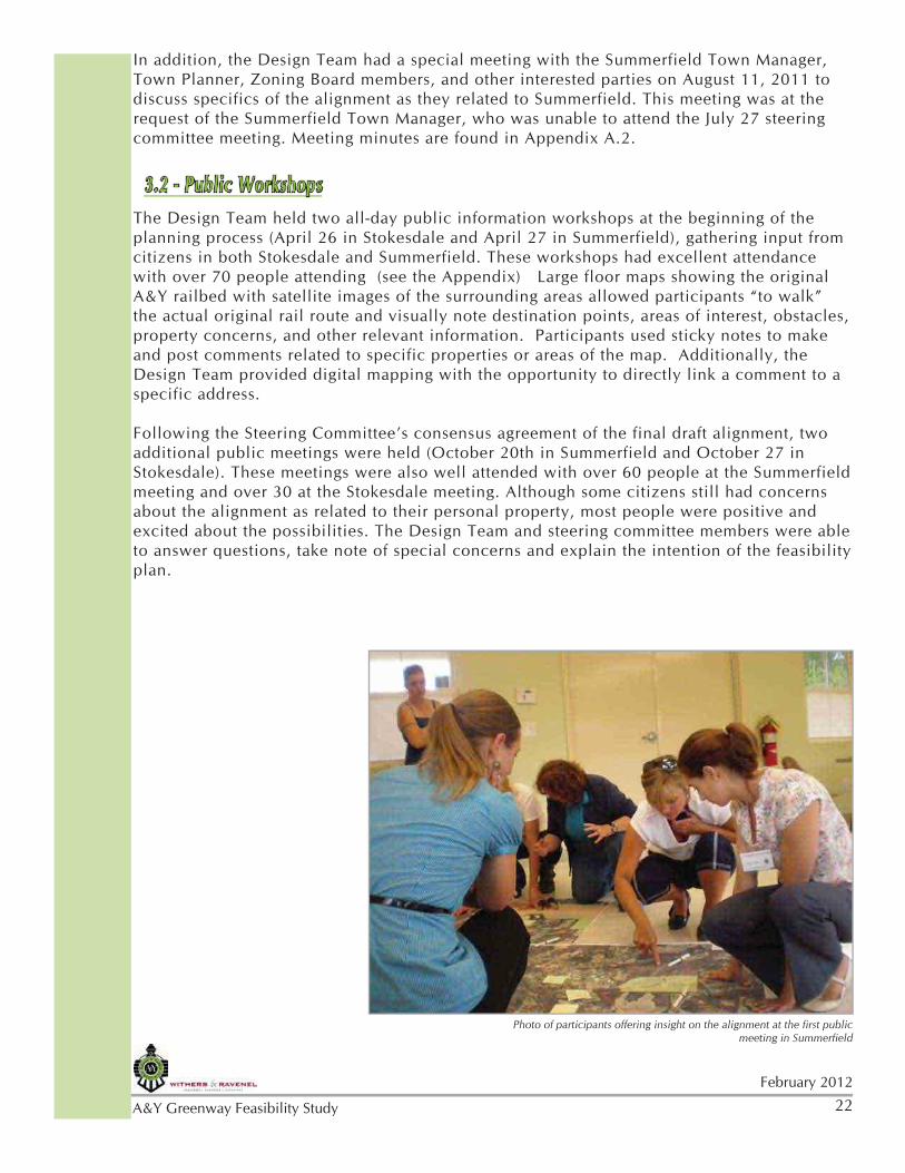
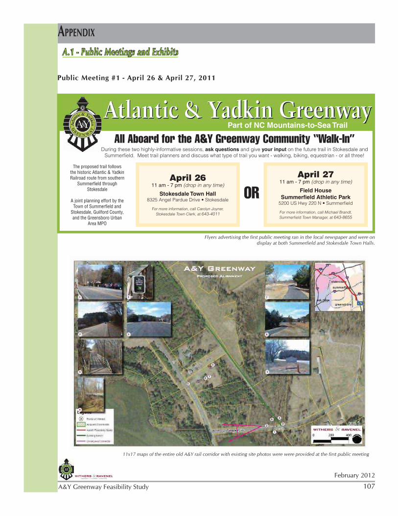
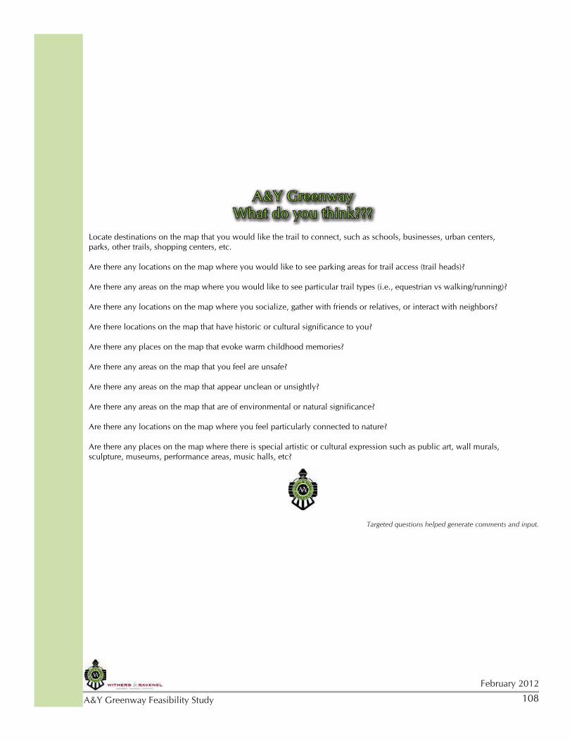
3.2 - Public WorkshopsThe Design Team held two all-day public information workshops at the beginning of the planning process (April 26 in Stokesdale and April 27 in Summerfield), gathering input from citizens in both Stokesdale and Summerfield. These workshops had excellent attendance with over 70 people attending (see the Appendix) Large floor maps showing the original A&Y railbed with satellite images of the surrounding areas allowed participants “to walk” the actual original rail route and visually note destination points, areas of interest, obstacles, property concerns, and other relevant information. Participants used sticky notes to make and post comments related to specific properties or areas of the map. Additionally, the Design Team provided digital mapping with the opportunity to directly link a comment to a specific address.
Following the Steering Committee’s consensus agreement of the final draft alignment, two additional public meetings were held (October 20th in Summerfield and October 27 in Stokesdale). These meetings were also well attended with over 60 people at the Summerfield meeting and over 30 at the Stokesdale meeting. Although some citizens still had concerns about the alignment as related to their personal property, most people were positive and excited about the possibilities. The Design Team and steering committee members were able to answer questions, take note of special concerns and explain the intention of the feasibility plan.
Photo of participants offering insight on the alignment at the first public meeting in Summerfield
23
February 2012
A&Y Greenway Feasibility Study
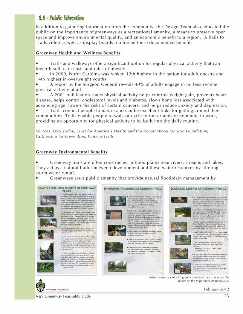
3.3 - Public EducationIn addition to gathering information from the community, the Design Team also educated the public on the importance of greenways as a recreational amenity, a means to preserve open space and improve environmental quality, and an economic benefit to a region. A Rails to Trails video as well as display boards reinforced these documented benefits.
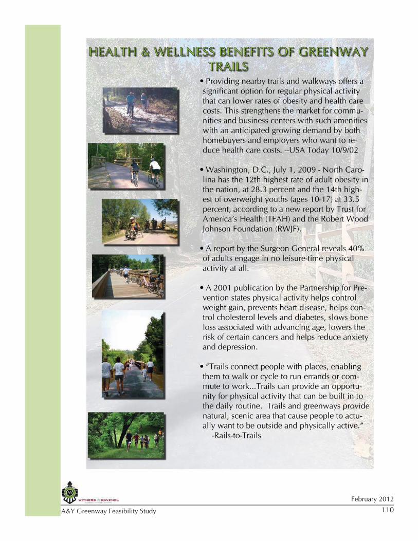
Greenway Health and Wellness Benefits
• Trails and walkways offer a significant option for regular physical activity that can lower health care costs and rates of obesity. • In 2009, North Carolina was ranked 12th highest in the nation for adult obesity and 14th highest in overweight youths.• A report by the Surgeon General reveals 40% of adults engage in no leisure-time physical activity at all.• A 2001 publication states physical activity helps controls weight gain, prevents heart disease, helps control cholesterol levels and diabetes, slows bone loss associated with advancing age, lowers the risks of certain cancers, and helps reduce anxiety and depression. • Trails connect people to nature and can be excellent links for getting around their communities. Trails enable people to walk or cycle to run errands or commute to work, providing an opportunity for physical activity to be built into the daily routine.
Sources: USA Today, Trust for America’s Health and the Robert Wood Johnson Foundation, Partnership for Prevention, Rails-to-Trails
Greenway Environmental Benefits
• Greenway trails are often constructed in flood plains near rivers, streams and lakes. They act as a natural buffer between development and these water resources by filtering storm water runoff. • Greenways are a public amenity that provide natural floodplain management by
Posters were created with graphics and statistics to educate the public on the importance of greenways.
24February 2012
A&Y Greenway Feasibility Study
buffering streams and rivers and preventing development in these flood prone areas. Approximately 10 million homes are located in floodplains across the country and FEMA estimates that flooding causes more than $1 billion in property damage every year. • Trails provide unfragmented corridors and habitat to many plant and animal species, promoting biodiversity. • Greenway trails offer an alternative form of transportation that does not use the automobile, thus reducing the burning of fossil fuels and improving air quality. • Greenway trails and interpretive signage can act as an outdoor classroom, promoting environmental awareness and appreciation for the natural environment.
Sources: National Floodplain Insurance Program, Federal Emergency Management Agency (FEMA)
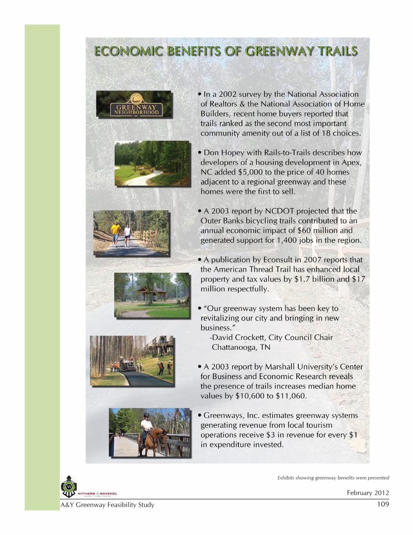
Greenway Economic Benefits
• A 2002 real estate survey showed recent home buyers ranked trails as the second most important community amenity out of a list of 18 choices. • Developers of a housing development in Apex, NC, added $5,000 to the price of 30 homes adjacent to a regional greenway and these homes were the first to sell in the development.• A 2003 report projected that the Outer Banks bicycling trails contributed to an annual economic impact of $60 million and generated support for 1,400 jobs in the region. • A 2007 publication reports that the Carolina Thread Trail has increased local property values by $1.7 billion and tax values by $17 million. • A 2003 report stated that the presence of trails increased median home values by over $10,000.
Sources: National Association of Realtors and the National Association of Home Builders, Rails-to-Trails, NCDOT, Econsult, Marshall University’s Center for Business and Economic Research
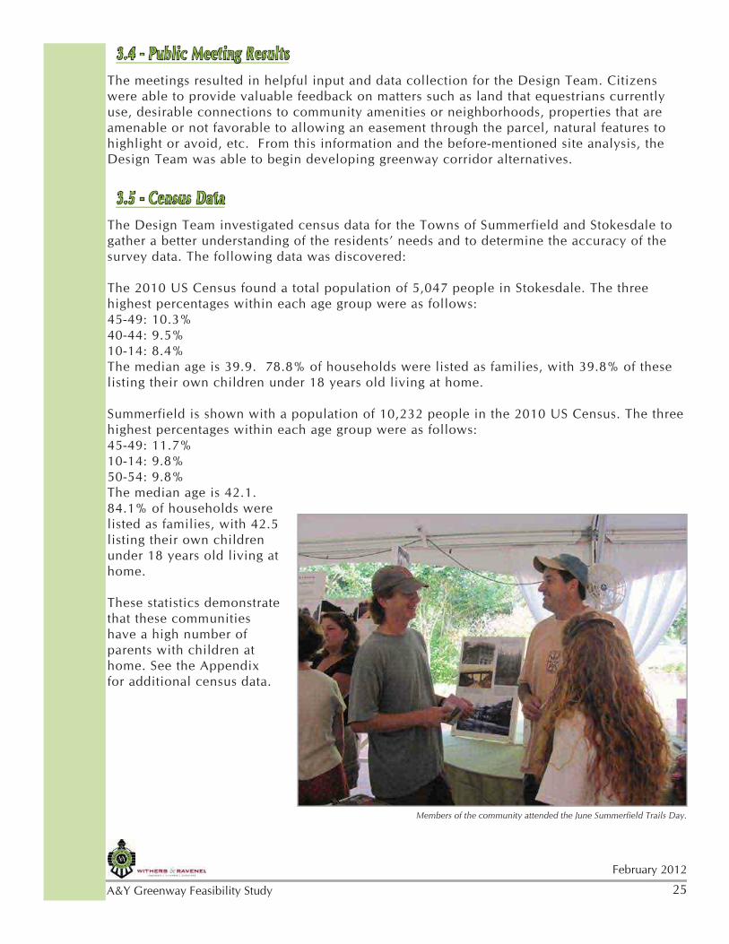
Greenway information was provided at both sets of public meetings, as well as at the Summerfield Trails Day event in June.
25
February 2012
A&Y Greenway Feasibility Study
3.4 - Public Meeting ResultsThe meetings resulted in helpful input and data collection for the Design Team. Citizens were able to provide valuable feedback on matters such as land that equestrians currently use, desirable connections to community amenities or neighborhoods, properties that are amenable or not favorable to allowing an easement through the parcel, natural features to highlight or avoid, etc. From this information and the before-mentioned site analysis, the Design Team was able to begin developing greenway corridor alternatives.
3.5 - Census DataThe Design Team investigated census data for the Towns of Summerfield and Stokesdale to gather a better understanding of the residents’ needs and to determine the accuracy of the survey data. The following data was discovered:
The 2010 US Census found a total population of 5,047 people in Stokesdale. The three highest percentages within each age group were as follows:45-49: 10.3% 40-44: 9.5%10-14: 8.4%The median age is 39.9. 78.8% of households were listed as families, with 39.8% of these listing their own children under 18 years old living at home.
Summerfield is shown with a population of 10,232 people in the 2010 US Census. The three highest percentages within each age group were as follows:45-49: 11.7%10-14: 9.8%50-54: 9.8%The median age is 42.1. 84.1% of households were listed as families, with 42.5 listing their own children under 18 years old living at home.
These statistics demonstrate that these communities have a high number of parents with children at home. See the Appendix for additional census data.
Members of the community attended the June Summerfield Trails Day.
26February 2012
A&Y Greenway Feasibility Study
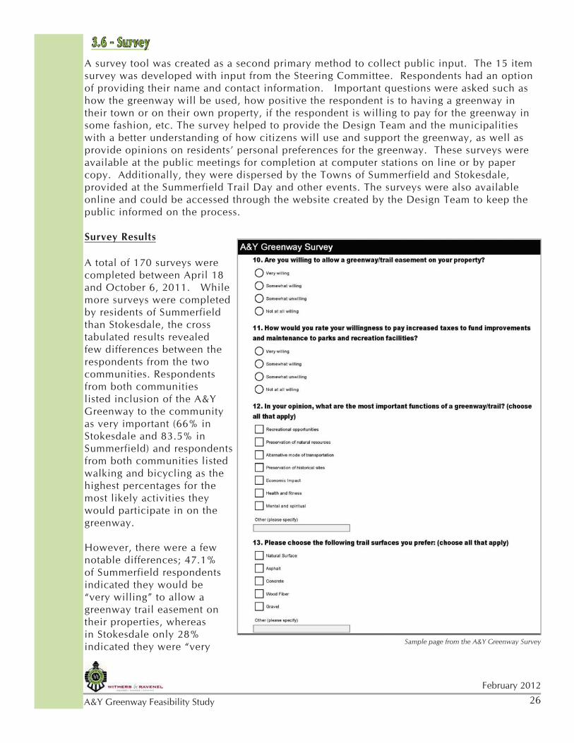
3.6 - SurveyA survey tool was created as a second primary method to collect public input. The 15 item survey was developed with input from the Steering Committee. Respondents had an option of providing their name and contact information. Important questions were asked such as how the greenway will be used, how positive the respondent is to having a greenway in their town or on their own property, if the respondent is willing to pay for the greenway in some fashion, etc. The survey helped to provide the Design Team and the municipalities with a better understanding of how citizens will use and support the greenway, as well as provide opinions on residents’ personal preferences for the greenway. These surveys were available at the public meetings for completion at computer stations on line or by paper copy. Additionally, they were dispersed by the Towns of Summerfield and Stokesdale, provided at the Summerfield Trail Day and other events. The surveys were also available online and could be accessed through the website created by the Design Team to keep the public informed on the process.
Survey Results
A total of 170 surveys were completed between April 18 and October 6, 2011. While more surveys were completed by residents of Summerfield than Stokesdale, the cross tabulated results revealed few differences between the respondents from the two communities. Respondents from both communities listed inclusion of the A&Y Greenway to the community as very important (66% in Stokesdale and 83.5% in Summerfield) and respondents from both communities listed walking and bicycling as the highest percentages for the most likely activities they would participate in on the greenway.
However, there were a few notable differences; 47.1% of Summerfield respondents indicated they would be “very willing” to allow a greenway trail easement on their properties, whereas in Stokesdale only 28% indicated they were “very Sample page from the A&Y Greenway Survey
27
February 2012
A&Y Greenway Feasibility Study
willing” to allow an easement. However, when considering the results of combining “somewhat willing and very willing”, the percentages are not as striking. For example, 58.9% of Summerfield respondents indicated they would be either very willing or somewhat willing to allow a greenway trail easement on their properties and 41.2% indicated they would be either somewhat unwilling or not at all willing to allow an easement. In contrast, 52% of Stokesdale respondents indicated they would be very willing or somewhat willing and 48% indicated they would be either somewhat unwilling or not at all willing to allow an easement.
In addition, 48.1% of Stokesdale respondents indicated they would be “somewhat willing” to pay increased taxes to fund improvements and maintenance, whereas 51.9% of Summerfield respondents indicated they would be “very willing” to pay increased taxes.
It is worth mentioning that the Town of Summerfield had already engaged in conversations with the public on the potential greenway alignment. One could assume that residents in Summerfield were already more familiar with the idea of a greenway and were therefore more amenable to the idea than residents of Stokesdale hearing of the greenway for the first time.
As an interesting note, 38 surveys were completed by residents who do not live in Summerfield nor Stokesdale. These individuals indicated they live in a variety of towns and areas near the greenway trail, including Oak Ridge, Greensboro, and Guilford County.
Over 57% of the surveys were completed by residents 50 years of age and over. This does not reflect the proportionate population ages of the two towns which is closer to 25% in this age group (CLRSearch.com). This prompts the Design Team to also consider trends, data, and experience from other trail studies and experiences to assure that the A&Y Feasibility Study also reflects the needs and desires of younger trail users and future generations of residents.
Regarding frequency of use, 40.5% use greenways/trails once or twice per week while 29.2% consider themselves infrequent users. For those who have not used a trail in the last year, 64.9% selected the reason as “access is too far” and “unsure where one is”.
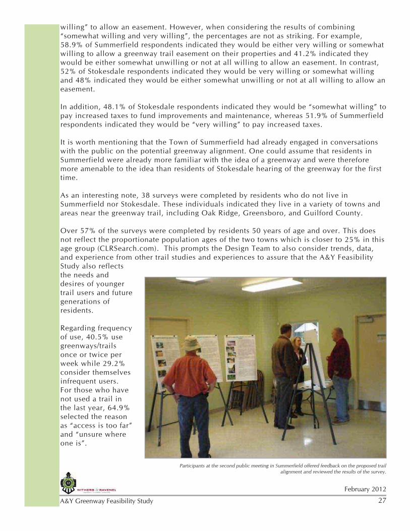
Participants at the second public meeting in Summerfield offered feedback on the proposed trail alignment and reviewed the results of the survey.
28February 2012
A&Y Greenway Feasibility Study
Residents overwhelmingly consider the A&Y Greenway important to them and their community. (76.2% “Very Important” to them and 74.1% “Very Important” to the community with only 5.5% “Unimportant” to them and 3.7% “Unimportant to the community).
The different types of trail-users impact design characteristics of the trail. As with virtually every trails survey, the predominant activity likely along the proposed A&Y Greenway is “Walking” (74.1% with 123 responses); “Bicycling” had 70 responses or 42.2% of responses; and 60 responders, or 31.3% included “Horse Back Riding.“ More than one choice could be chosen.
Trail amenities increase the desirability and, ultimately, the trail usage. The following amenities were chosen as an interest to more than 50% of the respondents: “Signage/Trail Markers,” “Trailhead Parking,” “Restrooms,” and “Benches/rest areas.” Respondents could “choose all that apply.”
While the vast majority of the respondents (77.2%) did not believe that their property was directly adjacent to the future greenway alignment, there was a close split between those “Very willing” (40.4%) and “Not at all willing” (34.6%) to allow a greenway/trail easement on their property. However, 21.2% were also “Somewhat willing” to allow an easement with only 3.8% “Somewhat unwilling.”
Very importantly, 76.8% of respondents were either “Very willing” or “Somewhat willing” to pay increased taxes to fund improvements and maintenance to parks and recreation facilities.
The top three most important functions of greenways/trails for the respondents were “Recreational opportunities” (84.6%), “Health and fitness” (82.7%), and “Preservation of natural resources” (65.4%).
The top two trail surfaces chosen by survey respondents included “Natural surface” (66.9%) and Asphalt (47.1%). Trail surface types influence trail uses, construction costs, and maintenance requirements and costs. Differences in trail surfaces will be discussedin more detail in Section 4.3 in chapter four.
Through an open-ended question, the Design Team gained valuable information about destinations that the trail might connect in the community. These are listed in the Appendix. Lastly, the respondents had an opportunity for any additional comments and these varied greatly as expected and the complete list of comments can also be found in the Appendix.
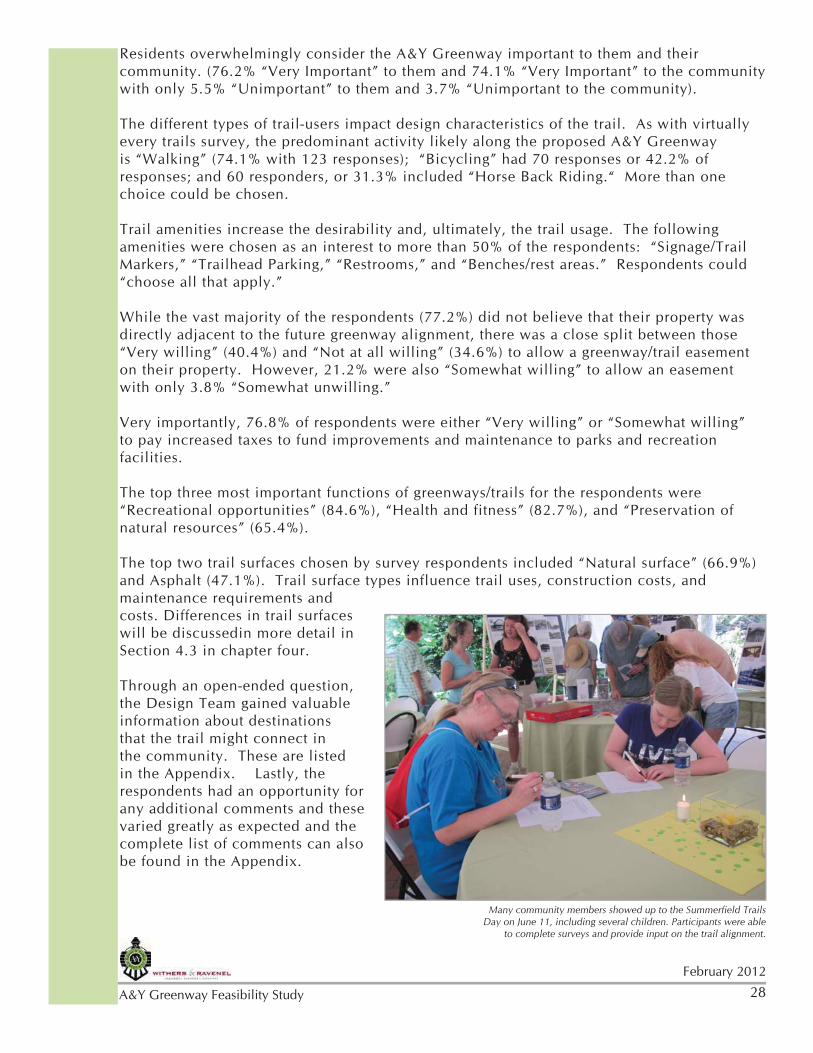
Many community members showed up to the Summerfield Trails Day on June 11, including several children. Participants were able
to complete surveys and provide input on the trail alignment.
29
February 2012
A&Y Greenway Feasibility Study
3.7 - Additional Public InputEquestrian
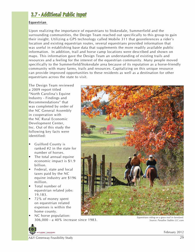
Upon realizing the importance of equestrians to Stokesdale, Summerfield and the surrounding communities, the Design Team reached out specifically to this group to gain their insight. Utilizing a GPS technology called Mobile 311 that georeferences a rider’s location and existing equestrian routes, several equestrians provided information that was useful in establishing base data that supplements the more readily available public information. In addition, trail and horse camp locations were described and shown on maps. This information gave the Design Team an understanding of existing trails and resources and a feeling for the interest of the equestrian community. Many people moved specifically to the Summerfield/Stokesdale area because of its reputation as a horse-friendly community with many farms, trails and resources. Capitalizing on this unique resource can provide improved opportunities to these residents as well as a destination for other equestrians across the state to visit.
The Design Team reviewed a 2009 report titled “North Carolina’s Equine Industry - Findings and Recommendations” that was completed by order of the NC General Assembly in cooperation with the NC Rural Economic Development Center, Inc. Out of this study the following key facts were identified:
Guilford County is • ranked #2 in the state for number of horses.The total annual equine • economic impact is $1.9 billion.Federal, state and local • taxes paid by the NC equine industry are $196 million.Total number of • equestrian related jobs: 19,183.72% of money spent • on equestrian related expenses is within the home county.NC horse population: • 306,000 - a 40% increase since 1983.
Equestrians riding on a grass trail in farmland. Source: Paradise Stables LLC.com
30February 2012
A&Y Greenway Feasibility Study
40% of state’s horses are kept for recreation and trail riding.•
School Representatives
Withers & Ravenel staff met with Summerfield Elementary School staff and Summerfield Town staff to discuss alternatives for the greenway trail proposed near the school playground and track. School representatives were concerned that the proximity of the trail would present safety problems and distractions for the children. Various alternatives were discussed and sketches were drawn to illustrate how the options would affect the school and DAR property. The sketches showed that a berm would take up a considerable amount of the school’s land and that a simple, decorative fence and plantings would create the necessary physical and visual separation from the trail.
Walking Tour with Stakeholders
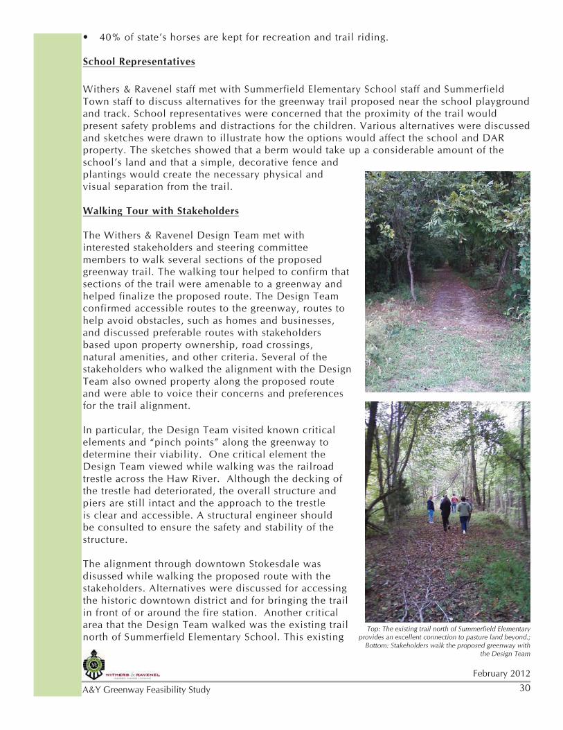
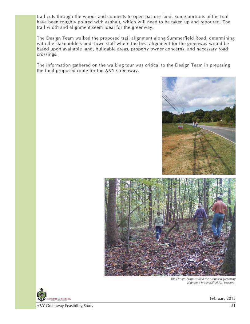
The Withers & Ravenel Design Team met with interested stakeholders and steering committee members to walk several sections of the proposed greenway trail. The walking tour helped to confirm that sections of the trail were amenable to a greenway and helped finalize the proposed route. The Design Team confirmed accessible routes to the greenway, routes to help avoid obstacles, such as homes and businesses, and discussed preferable routes with stakeholders based upon property ownership, road crossings, natural amenities, and other criteria. Several of the stakeholders who walked the alignment with the Design Team also owned property along the proposed route and were able to voice their concerns and preferences for the trail alignment.
In particular, the Design Team visited known critical elements and “pinch points” along the greenway to determine their viability. One critical element the Design Team viewed while walking was the railroad trestle across the Haw River. Although the decking of the trestle had deteriorated, the overall structure and piers are still intact and the approach to the trestle is clear and accessible. A structural engineer should be consulted to ensure the safety and stability of the structure.
The alignment through downtown Stokesdale was disussed while walking the proposed route with the stakeholders. Alternatives were discussed for accessing the historic downtown district and for bringing the trail in front of or around the fire station. Another critical area that the Design Team walked was the existing trail north of Summerfield Elementary School. This existing
Top: The existing trail north of Summerfield Elementary provides an excellent connection to pasture land beyond.;
Bottom: Stakeholders walk the proposed greenway with the Design Team
31
February 2012
A&Y Greenway Feasibility Study
trail cuts through the woods and connects to open pasture land. Some portions of the trail have been roughly poured with asphalt, which will need to be taken up and repoured. The trail width and alignment seem ideal for the greenway.
The Design Team walked the proposed trail alignment along Summerfield Road, determining with the stakeholders and Town staff where the best alignment for the greenway would be based upon available land, buildable areas, property owner concerns, and necessary road crossings.
The information gathered on the walking tour was critical to the Design Team in preparing the final proposed route for the A&Y Greenway.
The Design Team walked the proposed greenway alignment in several critical sections.
32February 2012
A&Y Greenway Feasibility Study
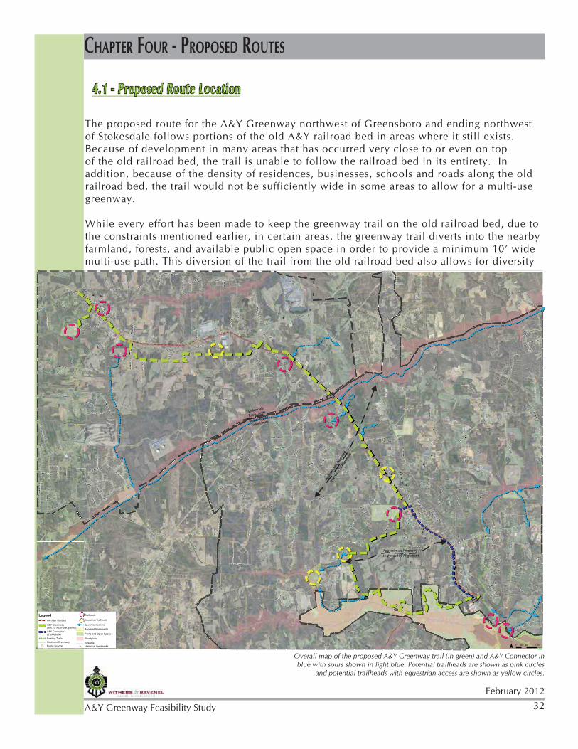
4.1 - Proposed Route Location
The proposed route for the A&Y Greenway northwest of Greensboro and ending northwest of Stokesdale follows portions of the old A&Y railroad bed in areas where it still exists. Because of development in many areas that has occurred very close to or even on top of the old railroad bed, the trail is unable to follow the railroad bed in its entirety. In addition, because of the density of residences, businesses, schools and roads along the old railroad bed, the trail would not be sufficiently wide in some areas to allow for a multi-use greenway.
While every effort has been made to keep the greenway trail on the old railroad bed, due to the constraints mentioned earlier, in certain areas, the greenway trail diverts into the nearby farmland, forests, and available public open space in order to provide a minimum 10’ wide multi-use path. This diversion of the trail from the old railroad bed also allows for diversity
CHAPTER FOUR - PROPOSED ROUTES
Overall map of the proposed A&Y Greenway trail (in green) and A&Y Connector in blue with spurs shown in light blue. Potential trailheads are shown as pink circles
and potential trailheads with equestrian access are shown as yellow circles.
of experience - giving users the chance to experience imrpoved viewsheds of pasture land, forests, and farmland. Numerous spurs to the trail are also proposed to connect users to existing trails, proposed scenic opportunities, neighborhoods, schools and other civic buildings, and parks.
Alignment Criteria
Criteria used to determine the location of the trail were as follows:
Location of the original railbed• - stay on, adjacent to or in close proximity as much as possible;Diversity in the desired character of the trail• - create a varied experience for the user by pulling the trail off of the road and into pasture land, forested areas, and public open space areas;Connectivity• - allow for connections to existing amenities, such as schools, parks, Town Hall, downtown business areas, other trails, equestrian riding areas and residential areas;Variety of users• - allow for a variety of users by creating a sufficiently wide easement for a soft surface equestrian and jogging trail adjacent to a hard surface bicycle/pedestrian trail where the opportunity is available;Existing easements• - use existing easements or known parcels where landowners are amenable to greenway easements as much as possible;Trailhead locations• - locate a variety of trailheads in areas where parking exists and can be shared or areas that are conducive to additional parking for increased trail access;Road crossings• - provide for road crossings (grade separated where possible) in areas where known road widening projects are planned or underway to capitalize on parallel construction.
Process
Before analyzing site data and compiling public input, the Design Team and municipalities made an initial assumption that the greenway would travel along the original A&Y rail corridor for the majority of this section of proposed trail. However, after compiling and analzying site data, walking portions of the trail, and gathering public input, it became apparent that many sections of the railroad corridor are not conducive to a greenway trail due to lack of easement, property ownership issues, physical obstacles in the path, or a lack of an appealing environment for a regional greenway trail.
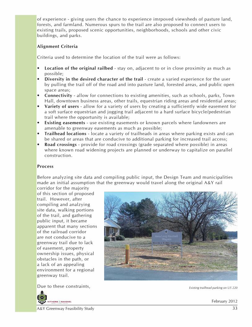
Due to these constraints, Existing trailhead parking on US 220
34February 2012
A&Y Greenway Feasibility Study
the Design Team proposed an alignment to the Steering Committee that diverted the A&Y Greenway out of the towns of Stokesdale and Summerfield, allowing for a wide, dual-surface trail, providing scenic views, and providing connections to existing trails and amenities. Sidewalk connectors through the towns were proposed.
The Steering Committee requested that the greenway trail be closer to the Towns and the original railbed. After taking the Steering Committee’s comments into consideration, the Design Team adjusted the alignment closer to Stokesdale and provided a sidewalk connector through Summerfield to address their concerns.
Trail Type and Width
The Towns of Summerfield and Stokesdale, along with Guilford County, the City of Greensboro, the Greensboro Urban Area MPO, and NC DENR entered a partnership to plan and implement a multi-use trail along the historic A&Y railroad bed in 2010. This agreement references the recommendations from the GUAMPO Bicycle, Pedestrian & Greenway Master Plan (BiPed Plan), adopted in 2006. The BiPed Plan’ Design Guidelines indicate that a multi-use trail shall be a minimum of 10’ wide and references AASHTO standards.
In order to provide a multi-use greenway trail for various users - bicyclists, runners, walkers, people pushing strollers, etc. a minimum 10’ wide asphalt trail should be installed along the entirety of the A&Y Greenway. Where possible, the trail should provide a 8’ wide gravel screenings course adjacent to the asphalt trail for equestrians. A 50 foot width easement is recommended wherever possible in order to allow for a dual-surface trail and flexibility for diversions around obstacles or an alternate route for equestrians. The exception to the 10’ minimum trail is the section along Summerfield Road, referred to as the “A&Y Connector”. This portion will be a 6’ wide sidewalk running along the road in order to provide desired pedestrian connectivity in an area that is not wide enough for a multi-use trail.
The American Association of State Highway and Transportation Officials (AASHTO) set standards on the development of bicycle facilities and multi-use paths. These standards must be met in order to receive most types of federal or state DOT funding. The AASHTO standards for a multiple use (shared use) trail recommend a minimum trail width of 10 feet and encourage the use of 12 feet or more where heavy or mixed uses are expected. This recommendation is an increase from the previous standard of 8 feet width. In addition, guidelines on shared use paths also recommend that these paths be connected to a transportation system in order to provide greater connectivity and ensure the trails are a transportation corridor, in addition to a recreational amenity. Finally, AASHTO standards also recommend against installing a multi-use path along a roadway, along driveway cuts or designating a sidewalk as a multi-use path. There are a number of specific reasons why a multi-use path along a roadway is unsafe, including dangerous intersections and encouraging bicyclists to travel against traffic, rather than with vehicular traffic.
If a sidewalk runs along a road, it is safer if bicycles do not ride on the sidewalk, but rather in the road. For this reason, the sidewalk connection proposed along Summerfield Road is only a 6’ wide sidewalk for pedestrians and is not intended as a multi-use trail. In order to meet the AASHTO standards for a multi-use trail, the A&Y Greenway is proposed in areas where the easement corridor can be wide enough for a minimum 10 foot wide trail, with a possible soft surface trail adjacent for equestrians. The 10 foot wide trail should also be made of a hard surface material, such as asphalt, in order to provide necessary transportation
35
February 2012
A&Y Greenway Feasibility Study
corridor needs, per AASHTO standards and accessibility needs, per ADA standards.
The dual-surface design allows the trail to meet the needs of multiple users and meet AASHTO safety standards, while also providing a surface suitable to equestrians. Dual-surface trail portions should be installed between equestrian trailhead locations to provide connectivity. Equestrians have indicated that a five-mile ride is the minimum length required for a reasonable ride, thus the dual-surface trail portions should strive to meet this minimum goal.
Finally, the Design Team recommends a 30-50’ wide easement for the greenway. A wider easement allows flexibility during design for location of the trail to address issues such as topography, tree preservation, and other obstacles. It also provides the opportunity to better screen adjacent properties, both enhancing the user’s experience and showing consideration for trail neighbors. In some areas, the final trail width may be realized over time through future Land Development Ordinance buffer regulations.
See section “4.8 - Typical Sections for Trails” for additional detail on trail widths.
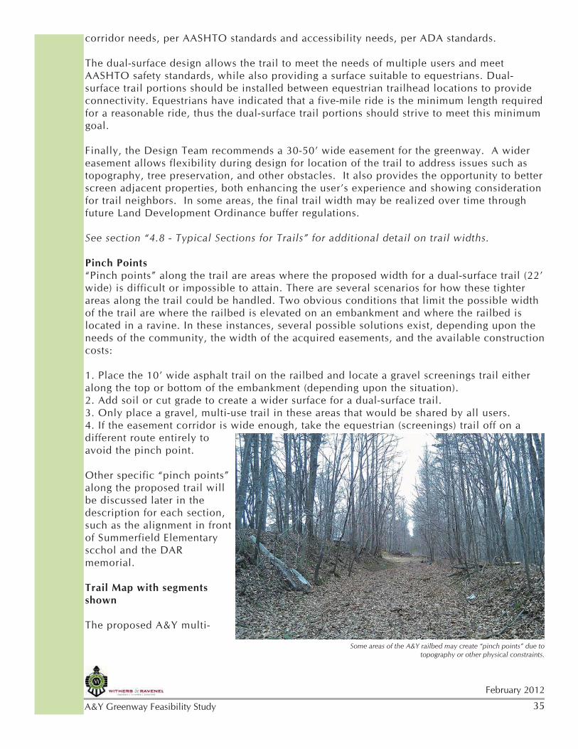
Pinch Points“Pinch points” along the trail are areas where the proposed width for a dual-surface trail (22’ wide) is difficult or impossible to attain. There are several scenarios for how these tighter areas along the trail could be handled. Two obvious conditions that limit the possible width of the trail are where the railbed is elevated on an embankment and where the railbed is located in a ravine. In these instances, several possible solutions exist, depending upon the needs of the community, the width of the acquired easements, and the available construction costs:
1. Place the 10’ wide asphalt trail on the railbed and locate a gravel screenings trail either along the top or bottom of the embankment (depending upon the situation). 2. Add soil or cut grade to create a wider surface for a dual-surface trail.3. Only place a gravel, multi-use trail in these areas that would be shared by all users.4. If the easement corridor is wide enough, take the equestrian (screenings) trail off on a different route entirely to avoid the pinch point.
Other specific “pinch points” along the proposed trail will be discussed later in the description for each section, such as the alignment in front of Summerfield Elementary scchol and the DAR memorial.
Trail Map with segments shown
The proposed A&Y multi-
Some areas of the A&Y railbed may create “pinch points” due to topography or other physical constraints.
36February 2012
A&Y Greenway Feasibility Study
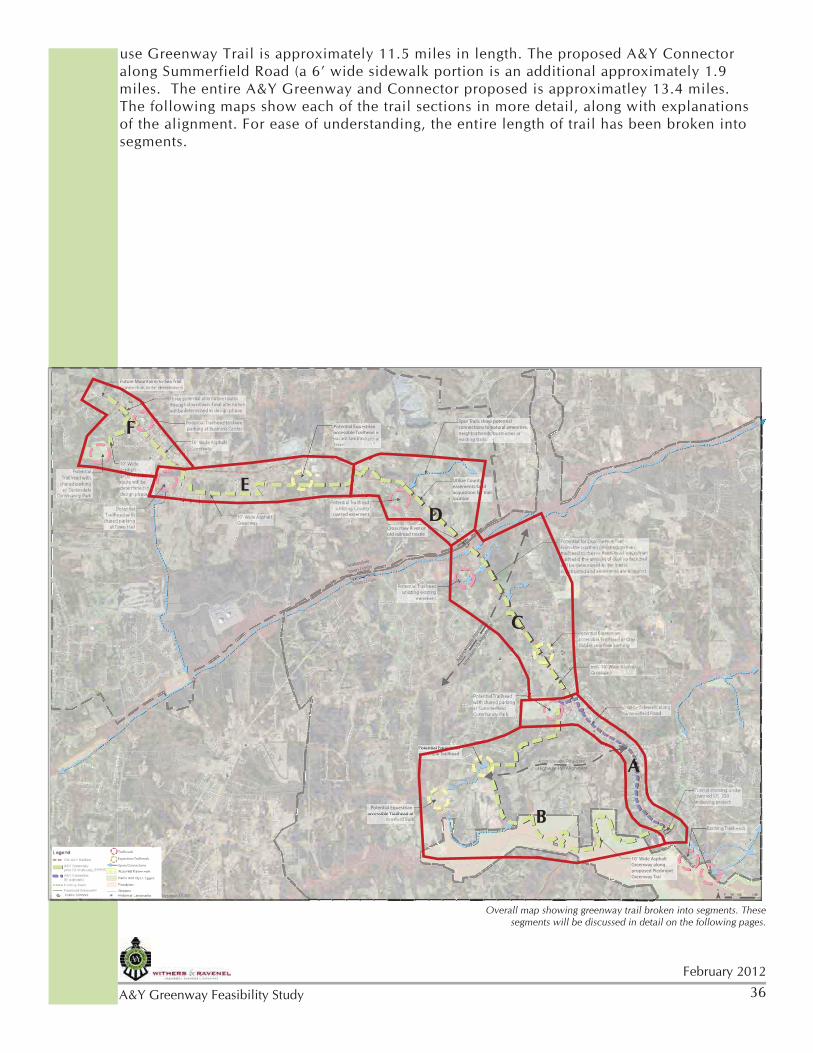
Overall map showing greenway trail broken into segments. These segments will be discussed in detail on the following pages.
use Greenway Trail is approximately 11.5 miles in length. The proposed A&Y Connector along Summerfield Road (a 6’ wide sidewalk portion is an additional approximately 1.9 miles. The entire A&Y Greenway and Connector proposed is approximatley 13.4 miles. The following maps show each of the trail sections in more detail, along with explanations of the alignment. For ease of understanding, the entire length of trail has been broken into segments.
[e
[e
[e
RD
ELL RD
FLA
SPOTS
B
RD
RO
GN
AS
ZACK
LEST
TINA LN
AY
LN
KHAKI PL
U
BR
LL DR
ements
pen Space
ndmarks
Spurs/Connections
Equestrian Trailheads
Trailheads
Potential Equestrian accessible Trailhead in
Potential Equestrian accessible Trailhead at
Potential Equestrian accessible Trailhead
Utilize County easements/land acquisition for trail location
Future Mountains-to-Sea Trail
10’ Wide Asphalt Greenway along proposed Piedmont Greenway Trail
Cross Haw River on old railroad trestle
Spur Trails show potential connections to natural amenities,
October 27, 2011
Approxim
ate P
ropos
ed
Inte
rstat
e 73 A
lignm
ent
Stokesdale
Town Limits
Summerfield
Highway 150 Alignment
EELLLL RRDD
LLNN
UU
ements
pen Space
ndmarks
Spurs/Connections
Equestrian Trailheads
Trailheads
e[[
RRDD
B
RRDD
RROO
GGNN
AAS
TTINNAA LLNN
AAYYAAA
KHAKHAKKI PPLL
BRBR
LLLL DDRR
e[[
FFLLAA
L
Potential Equestrianaaccessible Trailhead in
Potential Equestrian accessible Trailhead ataccessible Trailhead at
Utilize County easements/landacquisition for traillocation
LL
Future Mountains-to-Sea Trailta
LLEESSTTTT
10’ Wide AsphaltGreenway alongGreenway along proposed Piedmont Greenway Trail
Cross Haw River on old railroad trestleold railroad trestle
POOTTS
w potentialSpur Trails showwwSnatural amenities, raSSSPPPOOconnections to no n
October 27, 2011October 27, 01
opos
ed
ximat
e Pro
p
Approx
A
nmen
t
te 73
Alig
nm
Inte
rstat
e
Stokesdale S
LimitsTown Limits
SummerfieldS
fi ldummerfield
Summerfield
Highway 150 Alignment A
B
C
D
E
F
37
February 2012
A&Y Greenway Feasibility Study
Section A - From the existing trail at US 220 to Centerfield Rd.Approximately 1.9 milesSurface Type: Paved 6’ sidewalk along Summerfield RoadAnticipated Users: Walkers, joggersTrailheads: Existing trailheads to be used
The southern most portion of the proposed A&Y Greenway trail begins at the connection to the existing paved greenway trail. It is intended that this section of trail will be built concurrently with the US 220 road widening project which includes a grade-separated
[e
[e
[e
[e[e
SUM
ME
BU
W NC 0 HWY
DR
EI
RT
NA
S
STR
MAY
WATERTON RD
WEITZEL
DR
RD
BY D
R
OAK
N
RD
AIL LN
MA
RTIN
EMMACY
RD
SEMANTL
D
TANNE
IE D
R
SUM
MER
AUBURN RD
B-
LUB RD
D
AGLIANO TR
Y
EMP
VINSANTO WY
OW RD
ME
T
BIANC
e[[
e[[
eee[[[[[[
e[[ee[[[[
SSUUMM
MME
UBU
WW NNCC 0 HHWWYY
SSTTRR
MAAYYAAA
WWAAWWTTTTAAA ERRTTOONN RRDD
WWEITTZZELL
DDRR
RRDD
BYY
DDRR
OOOAKAK
NN
RRDD
AAILL LLNN
MMAA
RRTTINN
EMMACACYY
RRDD
SSEMMAAAAANNTTLL
DD
TTAATTT NNNNE
IEDDRR
SUUMM
MERR
AAUUBBUURRNN RRDD
D
AAGGLLIAA
YY
EMPP
VVINNSSAANNTTOO WWYYWW
OOWW RRDD
ME
TT
BIANCANC
DDR
EDD
RRE
ee[[[[[
6’ Wide Sidewalk along Summerfield Road
min. 10’ Wide Asphalt Greenway
10’ Wide Asphalt Greenway along proposed Piedmont Greenway Trail
LIAANNOO TTRRTunnel crossing under planned US 220 widening project
Existing Trailheads
Approximate Proposed Highway 150 Alignment
Section A - Connection to existing greenway trail; tunnel crossing at US 220; 6’ sidewalk along Summerfield Road.
38February 2012
A&Y Greenway Feasibility Study
A six-foot sidewalk could wind through existing trees in front of Summerfield Elementary School and the mobile home community on Summerfield Road.
crossing for the trail. The US 220 tunnel will provide a safe trail connection to Summerfield Road. The trail will then fork - providing a 6’ wide sidewalk along Summerfield Road and a 10’ wide multi-use trail along the proposed Piedmont Greenway through the Greensboro Watershed Buffer.
These trail options not only create a loop system in Summerfield, but also creates diverse opportunities for trail users - those who wish to walk through town to access businesses and residences and those who wish to bicycle, walk or run on a wider multi-use trail through natural scenery.
Section A shows the 6’ wide sidewalk along Summerfield Road starting on the west side of the underpass under US 220 and continuing along the west side of Summerfield Road. The existing mobile home community property has a lovely allee’ of red cedar trees on the road frontage. Careful design and construction of the 6’ sidewalk may allow its location between the trees, providing a shaded, protected, scenic walk through this area. The sidewalk continues along the west side of the road, passing by some existing residential properties.
Some residents have expressed concern over the location of the sidewalk on their properties along Summerfield Road. Although the six-foot wide sidewalk would cause minimal disturbance to individual properties, the exact location of the sidewalk will be carefully coordinated in this area due to resident preferences. For individual comments expressed at public meetings, see the notes in the Appendix.
The proposed route shows a mid-block crossing in front of the flea market where the sidewalk will continue along the east side of the road. Most homes in this area are located farther away from the road with the original railroad bed route visible and clear.
39
February 2012
A&Y Greenway Feasibility Study
The route will then cross Summerfield Road again at Myers Fork Road, traveling on the west side of the road to the Summerfield Elementary School property.
The sidewalk will meander as necessary to avoid and preserve the existing trees in the school’s road frontage. The sidewalk will also preserve, protect, and provide access to Bruce Park, home of the Guilford Battle Chapter DAR memorial to founder Charles Bruce, located between Summerfield Road and the school property. A sidewalk in this area will provide residents and visitors a better opportunity to view and appreciate this amenity. A fence should be included to separate the school, sidewalk and DAR tracts. A coordinated design and sidewalk connector implementation plan with representatives of Summerfield Elementary, DAR, and the Town will be necessary to assure that the goals of all groups are met.
The sidewalk will then cross Centerfield Road and turn left, providing access to both the Summerfield Community Park and the continuation of the A&Y Greenway.
There is an existing trailhead that can continue to be utilized at the southern end of this segment with a large parking area (Anna Long Marshall Wayside) along US 220 with direct trail access.
Spurs are suggested from the existing trail to provide greater access to residences and nearby horse farms.
Bruce Park with DAR memorial to founder Charles Bruce; existing conditions along Summerfield Road
40February 2012
A&Y Greenway Feasibility Study
Section B - From the tunnel at US 220 to the Summerfield Community ParkApproximately 4.3 milesSurface Type: Paved 10’ minimum multi-use trail; additional 8’ soft surface equestrian trail where possibleAnticipated Users: Walkers, joggers, bicyclists, equestriansTrailheads: Potential equestrian accessible trailheads in two locations: Armfield Park and vacant land near Brookbank Road. Potential trailhead at Summerfield Community Park.
This section of trail picks up on the west side of US 220 after travelling through the underpass. It follows the proposed route for the Piedmont Greenway through the Greensboro Watershed Buffer Open Space. The A&Y Greenway will cross Bunch Road and divert north, away from the Piedmont Greenway, following property lines and staying on the edge of usable land. The topography and existing streams in this area make portions of the parcels difficult to use for building or farming, but provide an opportunity for a trail to follow the streams along the top of the bank. This trail section takes an eastern turns and then wanders through pasture land terminating at Summerfield Community Park to the north.
The Design Team believes it is worthwhile to pursue the possibility of allowing horses in this area and providing a dual surface trail. In addition to local policies, the Department of Transportation’s Equestrian Design Guidebook for Trails, Trailheads and Campgrounds was also reviewed for specific equestrian needs.
The Greensboro Watershed Buffer policy typically does not allow paved surfaces nor horses.
[e
[e
BUNCH RD
HWYI
RT
NA
SA
HEN
SO
WYAT
RD
OOK DR
D
TRAIN
S
BASCOM DR
CT
OLEN LN
OW RD
BRIGADE TL
CT
A
e[[
e[[
UBUNNCCHH RRDD
HHWWYY
HHNEN
SSOO
WWYYWWW AAYY TTAAA
RRDD
OOOOKK DDRR
DD
TTRRAAINN
S
ABASSCCOOMM DDRR
CCCTT
OOLLENN LLNN
OOWW RRDD
RBRIGGAADDE TTLL
CCTT
AA
TT
6’ Wide Sidewalk along Summerfield Road
Potential Equestrian accessible Trailhead at
Armfield Park
Potential Equestrian accessible Trailhead
Potential Trailhead with shared parking at Summerfield Community Park
10’ Wide Asphalt Greenway along proposed Piedmont Greenway Trail
Approximate Proposed Highway 150 Alignment
Section B -Greenway trail through open space around Summerfield and alternate sidewalk plan through town along Summerfield Road
41
February 2012
A&Y Greenway Feasibility Study
However, the existing A&Y Greenway along and across Lake Brandt sets a precedent for paved surfaces in the watershed buffer. In addition, the proposed Piedmont Greenway is shown in the watershed buffer and the A&Y Greenway would simply follow the Piedmont Greenway in this area. The ruling on horses relates more to the distance from a water source and considering this is a tributary, not a primary water source, the rules may be more flexible. State rules typically dictate that a trail would need to be 30’ from the top of the stream bank of a primary water source. More stringent Jordan Lake Rules call for the trail to be 50’ from the top of the bank.
If it is determined that horses are not allowed in the watershed buffer, the opportunities to accommodate equestrians would be limited to a network of spur trails in the proposed equestrian trailhead area.
There are precedents allowing horses in the watershed buffer. In fact, some communities even provide access to the water for the horses to drink or allow equestrians to use buckets to water the horses. Texas Parks and Wildlife allow horses in state parks along rivers, but require that all equestrians carry a completed Animal Health Commission form stating that the horse has tested negative to an official Equine Infectious Anemia test within the previous 12 months. The New York Finger Lakes region allows horses on some trails and near streams, but requires the following: a negative Coggins test; no horses in camping areas; horses may not be tethered to live trees; no horse defecation on trails used by hikers or in or near streams. Numerous trails in California allow horses to access streams for water.
The NC Cooperative Extension states that water bodies should be protected from horse access by means of fencing. This is to limit erosion to the banks and limit manure deposits on the banks or in the water. Providing specific locations for water access for drinking or crossing only would limit disruption to the water body, while providing access to horses. Equestrians would be responsible for ensuring their horses do not deposit manure near the water and only access the stream in marked locations. Stream access points can be made of gravel or textured concrete to prevent erosion and reduce slippage for the horses.
The trail will follow the creek alignment as close as city regulations will allow for scenic views and public use of
otherwise unusable land.
42February 2012
A&Y Greenway Feasibility Study
The trailhead locations shown throughout the proposed A&Y Greenway are potential feasible locations. The map is not intended to suggest that all trailheads be constructed but rather general locations that are conducive to locating a trailhead. In this section, two potential trailhead locations are shown that could provide larger parking areas for equestrian access. The potential trailhead at Armfield Park would be connected to the A&Y Greenway with a spur trail. Vacant private property in the area adjacent to the trail provides a second option for development of an equestrian trailhead. Additionally, a potential trailhead is shown at the Summerfeld Community Park to capitalize upon existing parking and amenities. This trailhead would not provide equestrian parking and a parking study would need to be completed to ensure that shared parking for trail use could be accommodated. While ample parking is typically available during weekdays, congestion can occur during peak use times.
Summerfield Community Park has both paved and unpaved lots, providing opportunities for shared parking. During
events this parking can be congested.
43
February 2012
A&Y Greenway Feasibility Study
Section C - From Summerfield Community Park to the Haw River trestleApproximately 1.9 milesSurface Type: Paved 10’ minimum multi-use trail; additional 8’ soft surface equestrian trail where possibleAnticipated Users: Walkers, joggers, bicyclists, equestriansTrailheads: Potential equestrian accessible trailhead at Gray Gables overflow parking; potential small trailhead at Deboe Road easement.
This section of the greenway follows closely along the old A&Y railroad bed, traveling through open space and forests. Spurs are shown in blue leading to existing civic sites and natural amenities. Although the woods and brambles have grown up around the old railroad bed in this section, the bed appears to be mostly intact and there are few known obstacles, such as homes or businesses to circumvent. There is one residential neighborhood located on Whispering Pines Drive in Summerfield where the railroad bed crosses subdivided lots with existing homes. The trail would divert from the railbed, away from the homes and to the back edge of the properties or to the adjacent property to the west. Final alignment will be dependent upon negotiations with property owners.
Anecdotal stories of a waterfall to the east of the trail suggest a possible spur connection for the scenic opportunity. Another spur connection provides a loop around an existing pond
[e
[e[e [e
[e
[e
[e
[e
[e
[e
SCALES
DEB
OE R
D
JO
R
DR
DR
KO
OR
BLLIM
H
ON DR
RD
AMLE
RAS
HEN
SON
HAW VIEW CT
KHAKI PL
RD
DR
WHISPE
RO
M
AVEN DR
PE
Z
SY
ONK CT
RD
EMMAe[[
e[[e[[ e[[
e[[
e[[
e[[
ee[[[[eeee[[[[[
ee[[[[
e[[
SSCCAALLES
DDEB
OOOE
RRDD
JJOO
RR
DDRR
DDRR
KKOO
OORR
BLLLLIMM
HH
OONNDDRR
RRDD
AAMMLLE
RRAASS
HHAAWWAAVVIEWW CCTT
KHAKHAKKI PPLL
DRR
WWHHISPPE
RROO
MM
AAVVEAA NN DDRR
PPE
ZZ
SYSY
OONKNK CCTT
EMMMMAA
RRDD
6’ Wide Sidewalk alonSummerfield Road
DD
min. 10’ Wide Asphalt Greenway
RRDD
Potential for Dual Surface Trail - From the southern most equestrian trailhead to the northern most equestrian trailhead, the amount of dual surface trail will be determined as the trail is constructed and easements are acquired.
Potential Equestrian accessible Trailhead at Gray Gables overflow parking
Potential Trailhead utilizing existing
easement
HHENN
SOONN
Potential Trailhead with shared parking at Summerfield Community Park
Cross Haw River on old railroad trestle
Approxim
ate P
ropos
ed
Inte
rstat
e 73 A
lignm
ent
Section C -Greenway trail from Summerfield Community Park northwest through open space following the original A&Y railbed
44February 2012
A&Y Greenway Feasibility Study
The old A&Y Railroad bed has debris and overgrowth on it in this area, but appears to be largely intact.
close to the greenway trail. Spur connections to a possible trail along the Haw River would provide additional scenic and recreational opportunities, as well as connections to more residential neighborhoods, including Oak Ridge neighborhoods to the west.
Planning efforts should be initiated to create a greenway connection to the Town of Oak Ridge, further enhancing the regional trail system in this area of Guilford County. Survey data indicated that some Oak Ridge residents had participated in the survey and several Oak Ridge residents attended the public meetings to express their interest in the greenway trail and possible connections to their community.
Two potential trailheads are shown in this section, one using shared parking at a business overflow parking lot and one trailhead utilizing an existing easement.
Gray Gables, located at 4105 Oak Ridge Road, is a beautiful historic home that now functions as an event venue. The overflow parking lot is located adjacent to the trail and could be accessible to equestrians if the size requirements for trailers were met. There is a relatively steep slope accessing the site and upgrades would likely be necessary. The owners of Gray Gables have expressed a willingness to allow shared parking, but an agreement will need to be negotiated that both protects the business and provides adequate trail access.
The possible trailhead along Deboe Road utilizes an existing easement connecting to the greenway trail. Because this is a small, dead-end residential road, the trailhead should not be large, but rather a small access area with limited parking. This trailhead would be intended
45
February 2012
A&Y Greenway Feasibility Study
to be used mostly by nearby residences.
Spurs in this section show connections to scenic amenities and proposed trails along the Haw River. The proposed section of Interstate 73 that would cross the A&Y Greenway would allow for a grade separated crossing in this area.
The Summerfield Athletic Park is east of the A&Y Greenway and has the potential for a future connection to provide additional parking and a link to the park. However, the widening of US 220 makes this an unsafe connection without added amenities, such as a sidwalk along US 220 and a signalized crossing at NC150.
This portion of greenway could include dual-surface materials, allowing for equestrian usage. Equestrians could utilize the potential trailheads at Gray Gables, south of the Summerfield Community Park or on B&G Court, as shown in Section E.
This section of the A&Y Greenway trail culminates with the old railroad trestle spanning the Haw River. The trestle crossing is both culturally and historically significant as a resource and will be a focal point for the trail. Guilford County staff are negotiating trail access across the trestle. This access is critical to the connectivity of the A&Y Greenway and the entire regional trail system. An engineering structural integrity study needs to be performed and plans for upgrades such as new planking, guard rails, and approaches for safe access and use need to be developed and
Top: The existing railroad trestle over the Haw River Bottom: Improvements shown to a trestle along the American Tobacco Trail
46February 2012
A&Y Greenway Feasibility Study
implemented prior to incorporating the trestle as a part of the A&Y Greenway.
Section D - From the Haw River trestle to Ellison RoadApproximately 1.4 milesSurface Type: Paved 10’ minimum multi-use trail; additional 8’ soft surface equestrian trail where possibleAnticipated Users: Walkers, joggers, bicyclists, equestriansTrailheads: Potential trailhead at county owned easement.
Section D picks up on the north side of the Haw River, following along the old A&Y railroad bed through pasture land and forests. The railroad bed is intact in this area and mostly undisturbed with few known obstacles. There are some areas where the railroad bed is lower or higher than the surrounding land, which might necessitate guard rails or grading to ensure a continuous dual-surface trail.
A spur is shown connecting to existing horse farms and camps. This spur will allow equestrians and others to access the trail. As the old railroad bed turns west, the trail follows the railroad bed behind existing homes and then diverts away from the railbed in order to avoid a residential property.
The trail will follow the property line on the back of this property and come out on Ellison Road, where it will cross at the intersection with Shoeline Road. This home at the corner of Ellison Road and Shoeline Road has been identified as a “pinch point”, with a possible
[e
[e
[e
US
220N
ELLI
S
F SP
D
MO
MILL
R
PRO
VTH
DR
DR
YELLAV
PEED
OAK C
RD
RD
OD
NATA
EK CT
e[[
e[[
ELLLLI
S
FF
DD
MMILLLL
PPRROO
VV
OOAAKK CC
RRDD
EKK CCTT
e[[
MOO
TTHHDD
RR
Potential Equestrian accessible Trailhead in vacant land/industrial zone
RR
Potential Trailhead utilizing County
owned easement
Utilize County easements/land acquisition for trail location
Cross Haw River on old railroad trestle
SPP
DDR
YYE
Spur Trails show potential connections to natural amenities, neighborhoods, businesses or existing trails.
Section D- follows the old A&Y railroad bed closely through forests and pasture land, diverting at the end to avoid a residential parcel.
47
February 2012
A&Y Greenway Feasibility Study
alignment in the right-of-way along Shoeline Road at the front of the property. Poperty owner negotiations will determine the final alignment in this area.
The potential for a dual-surface trail which includes both a soft-surface 8’ wide trail and a 10’ wide paved trail in this area is high due to the integrity of the railroad bed, the availabilty of undeveloped land and the proximity to potential equestrian trailheads.
The potential trailhead shown in this section takes advantage of recently acquired land. Although the grade to access the trail is steep, with grading, this is a feasible trailhead location. However, because Shoeline Road is a dead-end, residential road, the trailhead should be kept smaller with the intention of primary use by nearby residents.
In Section D, the old A&Y railroad bed is clearly defined. Guilford County is purchasing land and easements in this area .
48February 2012
A&Y Greenway Feasibility Study
Section E - From Ellison Road to Stokesdale Town HallApproximately 2.2 milesSurface Type: Paved 10’ minimum multi-use trail; additional 8’ soft surface equestrian trail where possibleAnticipated Users: Walkers, joggers, bicyclists, equestriansTrailheads: Potential equestrian accessible trailhead in industrial area and trailhead at Stokesdale Town Hall.
In this section the greenway trail diverts from the original A&Y railroad bed. The railroad previously traveled along US 158, entering the town of Stokesdale. This section of the original railbed is visible but not optimal for the trail alignment due to the industrial uses and traffic speeds along US158. The trail turns to the south and travels through farmland and forests. While some property owners in this area have expressed willingness to allow trail access, property negotiations during implementation will dictate the specific alignment and connection across the farmlands south of US 158.
The A&Y Greenway is proposed to follow along property lines to Eversfield Road. Again, due to existing homeowners and businesses in this area, the exact route of the trail will need to be determined with landowners and the Town, but the suggestion is that the route turn south on Eversfield Road, then make a right into pasture land following along property lines.Upon reaching the existing subdivision off of Angel Pardue Road, the trail will likely be a 10’ wide trail at most in order to stay along the property line in this area. Again, conversations with adjacent land owners in this area could alter the exact alignment and width of the trail. The A&Y Greenway will then cross Angel Pardue Road, arriving at Stokesdale Town Hall.
[e
N RD
ATH
TREE
LINE
RD
AD
AN
O R
WNS
DR
RD
RD
RD
NEL
GYLL
OH
TRO
CLI
NT
OHT
TC
NE
EK CTNN
RRDD
AATTAAA HH
TTRREE
LLINNE
RRDD
AD
AN
AD
AN
OORR
WWNNS
DDRR
RRDD
TTRROO
CCLILI
NNTT
OOHHTT
CCNNE
EKK CCTT
TTCC
RRDD
e[[
Potential Equestrian accessible Trailhead in vacant land/industrial zone
RRDD
NNELL
GGYYLLYYY LL
OOHH
Potential Trailhead utilizing County
owned easementPotential
Trailhead with shared parking
at Town Hall
CC
10’ Wide Asphalt greenway. Final route will be determined in design phase.
10’ Wide Asphalt Greenway
10’ Wide Asphalt Greenway
Potential Trailhead to share parking at Business Center
Stokesdale
Town Limits
Summerfield
LimitsSection E -Greenway trail in open space around Stokesdale with
alternate sidewalk plan through town on US 158 and spurs to civic amenities.
49
February 2012
A&Y Greenway Feasibility Study
Stokesdale Town Hall and Park can serve as a trailhead by sharing parking and amenities. Another potential trailhead identified as a possibility for equestrian access is off of B&G Court. This industrial road off of US 158 has access to vacant land along the proposed trail. As part of an industrial area, horse trailers would not be as disruptive as in other more residential areas.
The greenway trail can come along the edges of properties, capturing some of the scenic beauty of the area. This photo is taken from the end of Pond Ridge Court.
50February 2012
A&Y Greenway Feasibility Study
Section F - From Stokesdale Town Hall to the US158/NC68 IntersectionApproximately 1.6 milesSurface Type: Paved 10’ multi-use trailAnticipated Users: Walkers, joggers, bicyclistsTrailheads: Potential trailhead at Stokesdale Community Park
This most northwestern portion of the A&Y Greenway trail begins at the Stokesdale Town Hall and travels along US 158 with connections to the Stokesdale Community Park, neighborhoods and downtown businesses.
The trail will travel north on Angel Pardue Road, turning west onto US 158. The trail will divert slightly around the water tower, coming out on the elementary school property and then following US 158 again. The trail will encounter a major road crossing at the intersection with NC 68 and will continue on the southern side of US 158. See Section 4.5 - Road Crossings for information on how to handle this highway crossing.
There are three potential alternatives through downtown Stokesdale that can be finalized in the design phase: travel in front of the fire station; travel behind the fire station; or cross US
[e
[e
[e[e
[eD
AD
AN
O
YN
OEP
E
D RD
UP
LE
T
UE R
D
Y RD
KEL
LY L
EE D
R
STPA
E
CO
RD
ERT
CLI
NTW
O
ME
SS
HOLT PARR
SPR
I
D
SPRW DR
LUTO
N RD
PON
RNET CV
LEG
NA
e[[
ee[[[[eeee[[[[[[[[[[eeeeeeee[[[[[[[[[[[[[[
e[[DD
AD
AN
AD
AN
OO
YYNN
OOEPP
E
DD RRDD
UUPP
LLE
TT
UU
YY RRDD
KKKELL
LLYYYYLLLLLE
EDD
RR
STTPPAAAA
E
D
ERRTT
CCLILI
NNTTWW
OO
MME
SS
HHOOLLTTLLL PPARRARRPP
SSPPRR
I
DD
SSPPRRWW DDRR
LLUUTTOO
NNRRRRDD
PPOONN
RRNNETT CCVV
LLEGG
NNAA
UUERRDD
Potential Trailhead with
shared parking at Stokesdale
Community Park
Potential Trailhead with
shared parking at Town Hall
CCOO
RD
RD
Future Mountains-to-Sea Trail Connection to be determined.
e[[
CC
10’ Wide Asphalt greenway. Final route will be determined in design phase.
Three potential alternative routes through downtown. Final alternative will be determined in design phase.
10’ Wide Asphalt Greenway
10’ Wide Asphalt Greenway
Potential Trailhead to share parking at Business Center
Section F -Greenway trail in open space around Stokesdale with alternate sidewalk plan through town on US 158 and spurs to civic
amenities.
51
February 2012
A&Y Greenway Feasibility Study
158 to the north side of the street and travel in front of the historic businesses.
Although a dual-surface trail is not proposed through downtown Stokesdale, the Town has shown an interest in possibly allowing equestrians, thus creating a link to the future Mountains-to-Sea-Trail connection at the northwestern terminus of the A&Y Greenway. The trail details will be determined at the time of trail design, but equestrians would likely need to share the asphalt or concrete trail with other users.
Some businesses in downtown Stokesdale have expressed a willingness to work with the Town on ways to incorporate the trail into downtown. One business owner located on Ellisboro Road has offered an area for trail users to park at the Business Center and other citizens have discussed opening a campground nearby to accommodate trail users.
A trailhead could also possibly share parking at the Stokesdale Community Park and allow an access point for trail-users at this end of the trail. As with some of the other shared parking locations, parking is ample at times, and other times such as during ballgames, parking is very limited. Some homeowners have expressed concern about additional congestion in this area and a parking study may need to be completed to determine the restrictions placed on parking.
For example, trail users could be asked to not park at the community park during certain hours and instead utilize the parking on Ellisboro Road. The Stokesdale Community Park is owned by the Parks and Recreation Association, a private, non-profit group. Therefore a parking agreement would need to be finalized and/or additional parking installed.
Spur trails are also shown here heading south toward Oak Ridge. The A&Y Greenway is considered to be a part of the Mountains-to-Sea Trail, a regional, cross-state trail. As such, at NC 68 on the western side of Stokesdale, the A&Y Greenway should plan to connect to the future Mountains-to-Sea Trail in this area. The exact location of the Mountains-to-Sea Trail in this area is not known at this time, but it is proposed to head northwest toward Hanging Rock State Park.
The old A&Y railbed is visible in downtown Stokesdale, along US 158. The planted island provides an ideal location for the greenway trail.
52February 2012
A&Y Greenway Feasibility Study
4.2 - Proposed Links & ConnectionsAs discussed in detail in Section 4.1, proposed spurs from the A&Y Greenway will connect existing and proposed trails, civic buildings such as schools and city buildings, neighborhoods, businesses, and natural amenities.
As a means of providing access to the downtown areas of Summerfield and Stokesdale, an alternate route will consist of a sidewalk plan through both towns that connects back to the greenway trail. This will allow a scenic, wider route for local and regional recreational opportunities with an alternate more urban sidewalk that connects Town businesses and residents.
Some of the proposed connections are to existing trails, such as frequently used equestrian trails located southwest of the proposed greenway. These equestrian trails wind through the countryside and along stream beds, providing off-road amenities to riders. Providing connections to these trails will allow an already active user group to ride farther and vary their rides.
Other proposed connections improve the existing and proposed network of local and regional trails already planned for this area by Guilford County. These future connections include possibilities for access to trails along the Haw River and other streams, access to possible natural amenities, such as ponds and waterfalls, and access to horse farms in the area that might provide their own access to the A&Y Greenway trail.
These spurs will create greater diversity along the trail, provide additional recreational and tourist opportunities, and provide access to more people who live near the trail. Sidewalks along the roads in Summerfield and Stokesdale will provide safe
connections among homes and businesses.
53
February 2012
A&Y Greenway Feasibility Study
4.3 - Trail Surfaces/TypesThere are many different types of trail surfaces. Concrete, asphalt, concrete or brick pavers, granite fines, dirt, and mulch have all been used in different applications. Some greenway trails may even incorporate borders of a different material, such as a stamped concrete border or an exposed aggregate border to differentiate them from a typical sidewalk or alert the users that they are near the edge of the path.
The type of material used is dependent upon many factors. A critical determining factor is the types of user expected on the trail, such as cyclists, joggers, individuals with strollers or wheelchairs, equestrians, or roller bladers. Cyclists, roller bladers and those with strollers or wheelchairs typically prefer a smooth surface, with limited joints. Joggers often prefer a softer surface, such as asphalt, that reduces knee strain and equestrians need a soft gravel or dirt surface to minimize the slipping of hooves on paved surfaces.
Another key element in considering the type of surface to use on a greenway is cost. Typically, concrete pavers are the most expensive, but can be very appropriate to differentiate a greenway trail in urban areas. Poured concrete is typically more expensive,
Comparison of surface mateirals for equestrian use.Source: USDOT, Federal Highway Administration
54February 2012
A&Y Greenway Feasibility Study
but more durable than asphalt.
A third critical consideration in choosing a greenway surface is the maintenance/longevity of the material. Concrete has a long lifespan and typically has less maintenance than asphalt because it cracks less. Concrete can also be repaired in segments more easily, making a repair less unsightly. Concrete pavers can be virtually maintenance free if applied with a sealant to repel stains and can be removed easily to access utilities under ground in urban settings. If installed properly asphalt can also have a long lifespan and has low repair costs. Asphalt usually requires routine maintenance to correct freeze/thaw issues resulting in potholes, sinks and cracks. Although mulch and screenings can be relatively low in cost to install, the costs to maintain these types of trails is high. The loose material can erode and become uneven from frequent use, and the mulch or screenings must be swept back onto the trail or replaced periodically.
Many greenway trails are made of asphalt due to the low cost, smooth surface and ease of installation. Asphalt is easier to install on rolling terrain and has an aesthetic most people are familiar with for multi-use greenway trails, as opposed to concrete sidewalks. As mentioned previously, joggers also usually prefer the softer surface of asphalt over concrete. Although asphalt often needs routine maintenance, the repair costs are typically low and has a long lifespan if installed properly on a compacted aggregate base course. After reviewing the different types of materials, it was determined that for the majority of the greenway trail, asphalt should be used. A hard-surface multi-use trail is also a requirement for Highway Transportation funding.
However, because equestrians are so prevalent in the area of the proposed A&Y Greenway, their needs must be considered as well. In fact, many people indicated their reason for moving to the Summerfield or Stokesdale area was to be closer to horse amenities. In order to reduce slipping and improve horse comfort, a non-paved surface should be used. (See Table 6-1 for a comparison of materials developed by the US Department of Transportation.) In comparing materials and talking with equestrians, it was determined that for areas that can accommodate horses, crushed rock with fines should be used. This material provides excellent traction for horses, is relatively dust free, is moderately low in cost, requires little maintenance and is not susceptible to displacement.
The A&Y Greenway should consist of a 10’ wide asphalt multi-use trail for the majority with a minimum 8’ wide single-rider crushed rock with fines equestrian trail running adjacent where possible. Generally, the dual-surface trail shall run between the potential equestrian trailheads at B&G Court in Stokesdale and at Grey Gables in Summerfield. The dual-surface treatment could be extended farther
Summerfield Athletic Park could be a trailhead with shared parking and water access opportunities for trail users.
55
February 2012
A&Y Greenway Feasibility Study
south to a potential equestrian trailhead off of Brookbank Road. In areas where the easement is too narrow to fit this “Dual-Surface” treatment, the equestrian trail may follow a slightly altered route, deviating from the greenway trail until it rejoins again.
4.4 - TrailheadsTrailheads should be located in areas that already have ample parking or space to expand existing parking facilities or created in new areas that provide desired access. Trailheads should include signage indicating the start of the trail and a map of the trail layout, as well as amenities such as litter receptacles, benches, and bicycle racks. If water connections are available, restrooms and drinking fountains should also be included. Designated trailheads should also consider providing appropriate facilities for equestrians, such as larger parking spaces for trailers (allow 80 feet x 30 feet per trailer to provide adequate space for loading and unloading); water for horses, and posts to tie up horses. Most of the suggested trailheads utilize existing park facilities, providing an opportunity for a less expensive upfit to meet the needs of the trail users rather than entirely new facilities.
Trailheads also offer an opportunity for educational signage, indicating such things as local fauna and flora, the history of the site and the former A&Y railroad, benefits of local water sources, and storm water requirements, such as the Jordan Lake Rules.
Specifically, potential trailheads are proposed at the following locations. Not all of these would necessarily need to be implemented, but each of these represent a potentially suitable location for a trailhead:
Utilize the existing trailhead • at the southern end of the trail. The new parking lot at US 220 (the Anna Long Marshall Wayside) is fairly large and provides clear access to the greenway trail. A trailhead at Armfield Park • could be a good location for equestrian access to the A&Y Greenway bypass around Summerfield. An alternative potential • trailhead for equestrian access along the Summerfield bypass
Trailheads can be simple or elaborate, but generally include a sign with a map indicating the path of the trail and simple amenities, such as a litter receptacle, bicycle racks and seating. The trailhead may also have restrooms and hitching
posts for equestrians.
56February 2012
A&Y Greenway Feasibility Study
trail is shown along Brookbank Road along undeveloped land. The Summerfield Community Park off of Summerfield Road has parking and amenities • that would appeal to trail users. Sharing these facilities would be a good use of resources, especially if used during park off-peak hours. A potential equestrian trailhead could possibly be located off of Medearis Street, if space allows and property owners are amenable.A potential equestrian trailhead could share parking at the Gray Gables overflow parking • lot.A proposed trailhead off of Deboe Road takes advantage of an existing easement through • a wooded area to the greenway trail. This portion of the greenway trail is equestrian friendly and there are many equestrian farms and facilities in the area, making equestrian access seem viable. This is a residential street, so parking would be limited and facilities kept to a minimum to reduce disruption.A potential trailhead could be located along Shoeline Road, utilizing a County-owned • easement in this area. Again, because this is a dead-end residential street, the trailhead should be small to not overload the street. A few parking spaces and access for neighbors who can walk to the trailhead would be ideal.A potential equestrian trailhead on the northern end of the trail could be located on • vacant land on an industrial commercial street off of US 158. The Stokesdale Town Hall has parking and an existing trail that could provide easy • access to the A&Y Greenway trail. The Stokesdale Community Park could be a good place for a trailhead to provide access • at one end of the A&Y Greenway, however there is limited parking available at this facility. Additional parking and restrictions on parking during games will need to be added in order to create a shared parking opportunity.A potential trailhead is proposed at the Stokesdale Business Center, located behind the • historic business core. The property owners here have expressed willingness to share parking, but a safe route from the parking to the trail would need to be designed.
A composting toliet along the American Tobacco Trail provides a necessary amenity to trail-users, while minimizing utility requirements.
57
February 2012
A&Y Greenway Feasibility Study
4.5 - Road Crossings
While grade-separated road crossings are optimal for greenways, at-grade crossings are typically unavoidable in some areas. Dealing with road crossings along a greenway in a safe, clear and effective manner for both pedestrians and vehicles is imperative. The proposed A&Y Greenway includes three types of at-grade street crossings:
The following measures should be considered when implementing the trail. While ensuring that all DOT and local standards are met, these are typical methods of handling various road crossings.
Mid-Block Crossings
Mid-block crossings should generally be avoided, but can provide pedestrian access by supplementing crossing options. Mid-block crossings may be used in areas where there are substantial pedestrian generators or where intersections along a roadway are spaced far apart. Mid-block crossings pose special problems for many state and local departments of transportation, since pedestrians will often choose to cross at the location that is the most convenient for them to do so, not necessarily where it is the safest. As a result, engineers and planners have developed guidelines for mid-block crossings.
Provide only on roads with a speed limit of less than 45 MPH.• Do not install within 300 feet from another • signalized crossing point.Base installation of a mid-block crossing on an • engineering study or pedestrian route placement.These crossings are recommended near schools, • pedestrian routes, retail areas, recreation, and residential areas.Require advance auto-warning signs and good • visibility for both the driver and the pedestrian.Providing a safe crossing point is necessary since • pedestrians tend to not walk far for a signalized intersection.Include a pedestrian refuge island on wide streets • that:
-Have fast vehicle speeds, or with large vehicle or pedestrian traffic volumes. -Where children, people with disabilities, or elderly people would cross. -Have complex vehicle movements.
Mid-Block crossing with warning signage.;Source: fhwa.dot.gov
Specific warning signage related to greenway crossings;Source: fhwa.dot.gov
58February 2012
A&Y Greenway Feasibility Study
The proposed A&Y Greenway has a mid-block crossing along Summerfield Road across from the flea market. The crossing is proposed to avoid homes that are close to the road in this area and to provide access from the west side of the road to the flea market and stores on the east side of Summerfield Road. A traffic study should ensure that a crosswalk is visible to drivers in this area.
A striped crosswalk with reflective or thermoplastic paint should be installed. Signage should warn drivers in advance to expect a pedestrian crossing. The crosswalk could also be raised to increase visibility of the crosswalk and slow cars down in anticipation of the crossing.
Typical Intersection Crossings
Most street crossings will occur at road intersections in order to take advantage of existing traffic signals and signage. Drivers are already slowing down and looking for traffic when approaching intersections, so including a pedestrian crossing is safer in these areas. To help drivers notice a pedestrian crossing, especially when one did not previously exist, crosswalks should be striped and pedestrian crossing signs added where possible. Signage should also be provided along the greenway trail to alert trail-users they are approaching
Busy Intersection Crossings at Highways or other Major Roads
By adoption of the alignment in this Feasibility Study, proposed highways and roads will need to accommodate the proposed trail in a safe manner. For example, in anticipation of the greenway crossing at US 220 near Summerfield Road, NCDOT has already made provisions to include a multi-use trail tunnel under the road during its road widening project. In the same manner, the route of proposed I-73 near Deboe Road will need to accommodate a safe, grade-separated crossing for the multi-use trail as the greenway is shown in this area.
However, existing roads and highways with no plans for improvements will not be required to alter their alignment or provide safe crossing amenities for the greenway trail. As such, a way for trail-users to safely cross the street is required when the trail is installed.
While other street intersection crossings exist along the trail (see above section), the busiest intersection that will need study is the crossing of NC 68 in Stokesdale. This highway has a high volume of traffic passing through Stokesdale at all times of the day, but particularly during rush hour commutes. The greenway is proposed to cross NC 68 at US 158 in order to have a safer intersection crossing with traffic lights. Upon implementation of the greenway, pedestrian signals should be installed. Audible and visible Pedestrian signalization or “Ped-Heads” should be installed at this intersection. The pedestrian signals could also include a push button device to trigger the light change
International symbol for a pedestrian crossing, along with a countdown signal.;
Source: ITE Pedestrian Bike Council
59
February 2012
A&Y Greenway Feasibility Study
more quickly in order to allow trail-users a more seamless crossing. These devices also encourage pedestrians to wait for the pedestrian signal to change rather than trying to risk crossing at an unsafe break in traffic. Countdown signals, such as the one shown in the photo at right, help make pedestrians aware of the time they have to cross a street.
Along with pedestrian signals, the intersections shall include highly visible pedestrian crosswalks to indicate to both drivers and pedestrians the proposed location for crossing the street safely. Other devices to alert drivers should also be utilized, such as flashing lights to indicate to drivers that they are approaching a pedestrian crossing and reduced speed limit signs. In addition, proper signage should be given for trail-users, warning them that they are approaching a busy intersection and should yield to cars and use caution when crossing. Pedestrian refuge islands are often required or desirable when crossing multiple traffic lanes.
A more detailed explanation of pedestrian crossings is included below.
Detailed Crosswalk Information
A marked crosswalk designates a pedestrian right-of-way across a street. It is often installed at controlled intersections or at key locations along the street (a.k.a. mid-block crossings). A study should be completed prior to placing crosswalks to determine the need and the best type and location of that crosswalk.
North Carolina state law permits crossing at all intersections whether the intersection is marked with a crosswalk or not. Every attempt should be made to install crossings in places where pedestrians are most likely to cross. A well-designed traffic calming location is not effective if pedestrians are using other unmodified and potentially dangerous locations to cross the street.
Marked pedestrian crosswalks may be used under the following conditions: 1) At locations with stop signs or traffic signals, 2) At non-signalized street crossing locations in designated school zones, and 3) At non-signalized locations where engineering judgment dictates that the use of specifically designated crosswalks are desirable.
There is a variety of form, pattern, and materials to choose from when creating a marked crosswalk. It is important however to provide crosswalks that are not slippery, are free of tripping hazards, or are otherwise not difficult to maneuver by any person including those with physical mobility or vision impairments. Although marked crosswalks provide strong visual clues to motorists that pedestrians are present, it is important to consider the use of these elements in conjunction with other traffic calming devices to fully recognize low
Advance stop bar at a crosswalk; Source: caactivecommunities.org
60February 2012
A&Y Greenway Feasibility Study
traffic speeds and enhance pedestrian safety.
Width of crosswalksMarked crosswalks should not be less than the width of the greenway or sidewalk. In downtown areas or other locations of high pedestrian traffic, a width of ten feet or greater should be considered. An engineering study may need to be performed to determine the appropriate width of a crosswalk at a given location.
Paint on crosswalksReflective paint is inexpensive but is considered more slippery than other devices such as inlay tape or thermoplastic. A variety of patterns may be employed as detailed in the figure above. Crosswalk markings should be white, per MUTCD. Crosswalk markings should extend the full length of the crossings. Crosswalk lines of 10-12 inches of width are the recommended minimum. Curb ramps and other sloped areas should be fully contained within the markings.
Pavement treatment of crosswalksA variety of colors or textures may be used to designate crossings. These materials should be smooth, skid-resistant, and visible. Although attractive materials such as inlaid stone or certain types of brick may provide character and aesthetic value, the crosswalk can become slippery. Also, as it degrades from use or if it is improperly installed, it may become a hazard for the mobility or vision impaired. Stamped and colored concrete or asphalt are also techniques that provide a more attractive and visible crossing. However, the paint on these techniques can wear off with use unless an integral colored concrete is used to ensure color throughout the concrete.
Raised CrosswalkIn areas with a high volume of pedestrian traffic, particularly at mid-block crossings, a crosswalk can be raised to create both a physical impediment for automobiles and a reinforced visual clue to the motorist. Raised crosswalks are typical on two-lane streets with a speed limit of less than 35 mph. In conjunction with raised crosswalks, it is necessary to use detectable truncated dome warnings at the curb lines. Visible pavement markings are necessary for the roadway approach slopes.
Advance Stop Bars
Vehicle and pedestrian visibility is increased by placing a vehicle advance stop bar 4 to 10 feet back from the pedestrian crosswalk at signalized crossings and mid-block crossings. In certain situations, a larger setback of the advance stop bar may be required. Advance stop bars are 1–2 feet wide and they extend across all approach lanes at intersections. The time and distance created allows a buffer in which the pedestrian and motorist can interpret each other’s intentions. Studies have shown that this distance translates directly Raiseed and stamped crosswalk;
Source: caactivecommunities.org
61
February 2012
A&Y Greenway Feasibility Study
into increased safety for both motorist and pedestrian. One study in particular claims that by simply adding a “Stop Here for Pedestrians” sign reduced pedestrian motorist conflict by 67%. When this was used in conjunction with advance stop lines, it increased to 90%.
Pedestrian Signals
Traffic signals assign the right of way to motorists and pedestrians and produce openings in traffic flow, allowing pedestrians time to cross the street. When used in conjunction with pedestrian friendly design, proper signalization should allow for an adequate amount of time for an individual to cross the street. The suggested amount of pedestrian travel speed recommended in the Manual on Uniform Traffic Control Devices (MUTCD) is 4ft/second. However, a longer crossing time may be necessary to accommodate the walking speed of the elderly or children. Therefore it is suggested that a lower speed of 3.5ft/second be used whenever there are adequate numbers of elderly and children using an area.
Engineering, as well as urban design judgment, must be used when determining the location of traffic signals and the accompanying timing intervals. Although warrants to fund pedestrian signal timing have been produced by the MUTCD, each site must be analyzed for factors including new facility and amenity construction (i.e. a popular new park or museum) to allow for potential future pedestrian traffic volume. In addition, creating better access to existing places may in fact generate a higher pedestrian volume.
Pedestrian Symbols
Countdown signals Countdown signals are pedestrian signals that show how many seconds the pedestrian has remaining to cross the street. The countdown can begin at the beginning of the WALK phase, perhaps flashing white or yellow, or at the beginning of the clearance, or DON’T WALK phase, flashing yellow as it counts down.
Audible signals Audible cues can be used to pulse along with a countdown signal. The signals are used for visually and audibly impaired individuals. Consideration should be paid to the noise impact on the surrounding neighborhoods when deciding to use audible signals.
Pedestrian signal timingsThe timing of these or other pedestrian signals needs to be adapted to a given situation. There are three types of signal timing generally used: concurrent (pedestrian Street crossing warning to trail-users
62February 2012
A&Y Greenway Feasibility Study
traffic flows with parallel vehicular traffic), exclusive (all vehicular traffic is stopped while pedestrians cross), and leading pedestrian interval (LPI) (pedestrians are given a few seconds head start before vehicular traffic). There are strengths and weaknesses to each system, which should be studied at the time of installation.
Cross Alert System
As an alternative or addition to a push button crossing system, the Cross Alert System of warning lights and signage provides an advance alert to approaching vehicles that greenway trail users are at or near the intersection. The system uses motion activation to sense trail users and can be hard wired into the electric grid or run off of solar power. A Cross Alert System has been used at greenway crossings elsewhere in Greensboro and has proved useful and effective.
4.6 - Trail Signage, Amenities & DetailsCreating a desirable greenway trail includes providing amenities along the trail and proper signage. At a minimum, amenities include benches and trash receptacles for users. Amenities should be durable to withstand frequent use and being outside in the elements. One “package” of amenities should be used throughout the trail to provide a consistent look and feel.
Signage should direct greenway trail users to trailheads and spurs, advise users of hazards, road crossings or scenic opportunities, and provide trail name recognition. Signs providing direction are an excellent opportunity to direct tourists to downtown Stokesdale and Summerfield who may be in the need of a break, a meal or a place to stay.
The A&Y Greenway sign shall be used along the trail and at all trailheads to provide consistency and cohesion along the greenway. Maintaining the same “look” of the sign by using the A&Y Greenway logo will let trail users know which trail they are on and will provide name recognition for fundraising activities. The greenway may be funded by organizations that require signage indicating the funding source, such as Rails-to-Trails or PARTF grants. In addition, this section of the A&Y Greenway will be a part of the Mountains-to-Sea Trail. To avoid confusion with all of the possible signs and logos, a consistent look to the signs should be maintained, additional sign posts should be minimized, and signs should be clustered at trailheads.
Trail signs also provide rules and regulations along a trail. Typical trail rules often posted along greenway trails include: 1. Horseback riders allow cyclists to pass.2. Horseback riders dismount to cross bridges and trestles.
Signage along the trail can provide directions, rules or warnings and can be made of various materials and sizes.
64February 2012
A&Y Greenway Feasibility Study
Top: GPS coordinates on trail markers provide users with an accurate location of where they are.Left: Traditional elements of trash bins and benches should be located along the trail.
Right: Restroom facilities can be simple pre-fabricated buildings with decorative wood or brick.
3. Non-motorized traffic only. (Personal Assistive Devices allowed)4. Stay on trail. 5. No hunting within 50 feet of trail or across trail.6. Trail closed at sundown.7. Camping allowed in designated areas only.
GPS markers are an additional site item that will be included along the trail to provide emergency personnel with a way of locating people in trouble. These markers provide coordinates that pinpoint a location, as well as allow users who may be traveling the entire Mountains-to-Sea trail with a means of locating themselves along the route. Long-distance hikers and bicyclists often create blogs and GPS coordinates help provide information describing their journeys.
There are additional amenities along a greenway trail that should be considered that help create a special place to visit and spend time and help to ensure the safety and comfort of users.
Scenic rest areas located in strategic spots with picturesque views. These rest areas should include benches, tables for picnicking, trash bins, and possibly restrooms or water fountains. Additionally, covered shelters can provide protection from the rain and the sun and vending machines with drinks or snacks can provide a trail-user with much appreciated nourishment.
Restrooms and water fountains are typically located at trail heads, but can also be located along long stretches of a trail to provide trail-users a break on their journey. Water fountains with accommodations for dogs are recommended. In order to avoid providing water and sewer lines, restrooms can include composting toilets and hand sanitizer. Electricity can
65
February 2012
A&Y Greenway Feasibility Study
also be avoided by designing buildings to include natural light.
Watering troughs are necessary elements along portions of the trail that are open to equestrians - to provide clean and ample water for horses along their journeys.
Pedestrian or decorative lights are an attractive feature to include along trails near urban areas or neighborhoods where people might use the trails in the evenings more for exercise or to run errands.
Exercise equipment is sometimes included along a trail when the trail is used more by local residents for exercise. This is another reason for providing a wider easement corridor in the beginning to allow for such additions as the trail gains in popularity.
Safety bollards should be included along the greenway trail as needed. Safety bollards are often included at trailheads to deter motor vehicle access.
Fencing can be installed to promote both safety and provide direction to users. Fencing may be installed along curves in the greenway trail to encourage users to stay on the trail, along sections of the trail with little buffer between adjacent properties or along portions of the trail with a steep drop-off.
There are economic opportunities along the trail for privately owned amenities to occur. For example, campgrounds may develop nearby as the trail becomes more popular for hikers traveling along the Mountains-to-Sea Trail. The NC Trails Program strives to have campgrounds located every10-15 miles along the Mountains-to-Sea Trail. Restaurants, bike rental shops, convenience stores and other business enterprises may also develop near the trail.
A restaurant near the Virgina Creeper Trail. Source: glasspilot.com
66February 2012
A&Y Greenway Feasibility Study
Site amenities, such as benches and bicycle racks, can be opportunities to involve local artists or incorporate “brand identification” of the trail. Sculptures are also wonderful amenities along a trail and can provide a “sense of place” to users.
Sources: From top - daveburdick.com; Cooltownstudios.com; NC Museum of Art
4.7 - Public Art
Unique educational or artistic elements are often implemented along trails. Public art, either integrated or stand-alone, can be included in many varied ways. The art can function as a site amenity, such as a bench or trash can or can be incorporated into elements along the trail such as fencing, walls, bridge abutments, paving, etc. Art can also be incorporated into the trail as stand-alone sculptures or as an element of signage or an educational element.
Including elements such as these and involving artists in the design of the trail provides an outlet for unique expression, a way to make the trail interesting and aesthetically pleasing and helps to create a theme or “sense of place” for trail-users.
Public art can be incorporated into the trail at a later time as funding or grants allow. Art elements are also great ways to involve the local community, for example, a local scout group, school group, environmental group, historic group, equestrians, or others can install, build or design elements or support competitions to gain the interest and excitement of the community.
Some of the art and educational elements along the trail that could utilize the efforts of volunteers include: providing labels for plant species along the trail; providing signage for historic sites or events that occurred on or near the trail; providing signage on the histories of the communities; providing signage on the historic railroad; providing sculptures or other art elements.
67
February 2012
A&Y Greenway Feasibility Study
4.8 - Accessibility GuidelinesThe Americans with Disabilities Act (ADA) requires that all public trails reasonably accommodate people with disabilities. Trail and greenway requirements will differ from ADA standards for sidewalks. Although the Department of Justice has released a Notice of Proposed Rule Making (NPRM) for greenways, these guidelines have not yet been issued. However, creating an accessible greenway should be a stated goal for the A&Y Greenway.
The U.S. Access Board develops guidelines to comply with the ADA and has included specific language as related to greenway trails (Section 1017 Trails) that exist primarily for pedestrian use as a recreational or alternative transportation amenity. Additionally, new ADA guidelines as they apply to parking and restrooms will apply. The 2010 ADA standards can be found online at www.ADA.gov.
Although the trail should comply with ADA guidelines to the maximum extent possible, there are exemptions to the guidelines that allow for flexibility in specific scenarios. The U.S. Access Board states that if compliance with the guidelines would “cause substantial harm to cultural, historic, religious, or significant natural features or characteristics” portions of the trail may be exempt from certain accessibility guidelines. However, these exceptions need ample justification and will be scrutinized by local and state officials.
The sections of the A&Y Greenway located on a former railroad bed are conducive toward meeting the required ADA slope guidelines because the railbed provides a relatively flat, wide surface for trail construction. An asphalt trail will meet ADA guidelines of a firm and stable surface and will provide a safe means of transportation for both bicycles and Personal Assistive Devices, such as wheelchairs and motorized scooters.
As the survey results demonstrated, a large population of older residents support the trail and ensuring their ability to use the trail as they age is an important consideration.
Providing a smooth, stable surface provides accessibility to many types of users. Source: Connswater Community Greenway, UK - Avec Photography
68February 2012
A&Y Greenway Feasibility Study
4.9 - Typical Sections for TrailsThe Design Team recommends three standard sections for the A&Y Greenway. In order to provide flexibility in design and adequate dimensions and surface types for multiple users, every effort should be made to attain these general dimensions. However, these are merely guidelines and actual on-ground conditions will determine actual widths and layouts. A 30 -50’ wide easement is recommended in order to provide enough room to construct the trail and avoid potential hazards. Striving for the widest easement possible will allow the trail designers the ability to design the trail as needed around difficult obstacles, topography or natural amenities.
Typical Section One shows a dual-surface trail through the woods with a 50’ easement corridor to allow flexibility in design. The trail is made up of a 10’ wide asphalt portion with an 8’ wide screenings trail adjacent. Standard 2’ shoulders on either side of the trail should be included in the dimensions for planning purposes. By acquiring a 30- 50’ wide easement wherever possible, the trail designers will have the flexibility to take the screenings trail away from the asphalt trail occasionally, in order to avoid obstacles or create a more varied user experience. A wider easement also provides the ability to create a buffer in some areas to benefit the adjacent land owners and to enhance the experience of the user.
30' CORRIDOR
50' CORRIDOR
TYPICAL SECTION 1DUAL SURFACE TRAIL OFF ROAD30-50’ CORRIDOR
69
February 2012
A&Y Greenway Feasibility Study
Typical Section Two shows an asphalt (or possibly concrete) trail adjacent to a roadway. This is a condition that would occur closer to towns or near residential neighborhoods. The section shows a 10’ wide trail to provide for multiple users. However, there are some areas, such as Summerfield Road, where a 10’ wide trail will not be possible. In this area, a 6’ wide sidewalk along the entire road is recommended, rather than varying widths to provide continuity. The easement corridor is more narrow along the roadway, as the need for flexibility is somewhat diminished. The trail will follow the road and will need to vary only when there are obstacles or conditions that require a subtle diversion.
Typical Section Three shows a condition of a 10’ wide multi-use asphalt trail off-road. This may be the initial condition for much of the trail, before additional funds are attained to create a dual-surface trail. The section shows the difference between acquiring a 50’ easement versus a 30’ easement.
20' CORRIDOR
30' CORRIDOR50' CORRIDOR
TYPICAL SECTION 2ASPHALT TRAIL NEXT TO ROAD20’ CORRIDOR
TYPICAL SECTION 3ASPHALT TRAIL OFF ROAD30-50’ CORRIDOR
70February 2012
A&Y Greenway Feasibility Study
5.1 - Phasing
The Design Team offers a list of phasing recommendations that can make implementation of the entire A&Y Greenway more manageable and practical. These recommendations are based upon existing land acquisition or funding and probable high-interest levels in certain segments of the trail. For example, sections of the trail near downtown or residences may be in greater demand than some of the sections in the countryside. However, the trail does not have to be phased in any particular order and some of the phases could occur concurrently. As public interest, funding opportunities and land acquisition occur, the trail should be implemented as practical.
The following criteria serve as a guide to be utilized in determining realistic phasing and installation of the trail:
1. Opportunity Land Acquisition
As properties and easements along the proposed trail become available either through fee simple or easement purchase, land bequests, or donations, these sections of trail could be allocated and constructed as a first phase. As an example, Guilford County staff members are currently obtaining easements and have indicated that funding is available to initially install a gravel surface in sections of the trail.
Highway ImprovementsHighway and Interstate projects, such as I-73, the NC 150 realignment, the widening of US 220, and the future realignment of US 158, are opportunities to install portions of the trail along with the highway project, potentially conserving funds and gaining improved access through the inclusion of road crossings, especially those that are grade-separated. Appropriate connections to crossings should be constructed concurrently or as soon as financially feasible.
Land DevelopmentAs vacant land is developed, easements should be acquired. Land development ordinances may need to be reviewed and modifications made to provide the mechanism for easement protection and dedication. Land development may influence the exact location of the final trail alignment. Consideration should be given for the land developer to actually build the trail and donate it as a fee-in-lieu option.
GrantsThe attainment of grants to provide funding for sections of the trail will likely be the major determinant for trail implementation. Since grant funding typically requires participation from the government agency in the form of a match, capital planning will be necessary to maximize the leveraging of funds. The type of grant funding will determine the section of trail to be constructed. For example, DOT grants will require paved sections of the trail to be built and logical termination points that can be used as transportation corridors. Other types of funding (see 5.4 - Funding Sources)
CHAPTER FIVE - IMPLEMENTATION
71
February 2012
A&Y Greenway Feasibility Study
would focus on specific issues or attributes, such as protecting natural resources, highlighting cultural resources, providing safe routes to schools, etc.
2. Proximity to ResidentsAnother criterion for trail installation is the service level for existing residents. A section of trail in close proximity to and accessible to residents will increase trail usage, providing a valued recreation and transportation amenity. Residents will be much more supportive of a trail that is easy to access and allows for a positive recreation experience.
3. ConnectivityAlthough sections of the trail can be built as property is acquired or grants approved, connectivity needs to be considered to maximize trail use and benefit. This includes connections to community facilities, businesses, scenic areas and other neighborhoods. Loops are also desirable. Short, disjointed trail segments should be avoided to the extent possible and proper signage should direct trail-users to the next section.
4. Logical or Accessible Termination PointsAn additional element to consider is where and how the trail segments terminate. While the provision of a connected network of trails remains important, the trail segments should also end and begin in logical locations, such as proposed trailheads or other points accessible to pedestrians and bicyclists. A safe entry point with clear signage and access from a sidewalk or roadway is needed to ensure trail-users can easily and safely access the trail.
Entrances to the Greenway should be clearly marked. Source: Raleighnc.gov
72February 2012
A&Y Greenway Feasibility Study
5.2 - Property AcquisitionProperty acquired for the A&Y Greenway will generally occur by voluntary landowner sales or gifts to local governments. Local governments may acquire land through fee simple purchase, easement purchase, or donations.
EasementGreenway easements provide the ability for a local government to construct and maintain a greenway in a corridor across a land owner’s property, while the property owner still officially owns the land. This is a common way to create greenways across multiple properties or provide public amenities as is customary with sewer and water lines.
PurchaseIn some instances, a fee simple land purchase may be the most reasonable alternative or a more desirable solution for a landowner. The local government can purchase the land out-right, making the land public property. Strategic acquisition of properties that add to existing public parks or preserve other community and natural resources warrants consideration by the local government.
Development OrdinanceLand for a greenway trail can also be acquired through the Town or County’s Land Development Ordinance. At the time land is developed into subdivisions or commercial properties, a portion of it could be required to be dedicated for public easements. Buffer regulations can help screen development from the greenway trail. The results of the approved A&Y Greenway Feasibility Study should be integrated into each community’s comprehensive land use plan. Regulation through Ordinance can be a successful way to acquire land for greenway development.
DonationsDonations or gifts of land may be accepted by government jurisdictions. Tax benefits may be available to landowners who donate land or easements for this type of public purpose. Land owner education about the benefits of land donation and conservation may encourage donations. Working with local land conservation groups can be a beneficial way to acquire land for greenways.
73
February 2012
A&Y Greenway Feasibility Study
5.3 - Cost Estimate
The A&Y Greenway Feasibility Study provides numerous recommendations for the integration and location of multi-use facilities and amenities. An estimation of probable costs based on the study options and recommendations are provided below. At the time of design, actual site conditions as well as decisions made related to materials, construction specifications, amenities, and other factors will impact the final cost estimate. The cost estimate chart is presented such that multiple implementation options and phasing plans can be evaluated by costs.
Land acquisition costs are not included in the cost estimate. An additional 7-10% should be added for design and construction administration. For comparison purposes, the 4.67 mile Chatham County section of the 26 mile American Tobacco Trail cost approximately $2.1 million in 2008 This dual-surface section of the ATT (a 10’ asphalt multi-use trail and an adjacent 6’ gravel screenings surface) included two railroad trestles with minimal road crossings and no trailhead facilities included in the trail construction phase. An additional $20,000 was budgeted for signage in this section. The entire trail was built on the actual railroad bed.
thll
ulo
ci0
as
Foof mimutwofac$2wa
General greenway costs include surface costs, possible
bridges or culverts in some wet areas, and amenities such
as benches, restrooms, and signage.
74
February 2012
A&Y Greenway Feasibility Study
Costs can be highly variable due to site factors and cost fluctuations. These costs are based on historical data and are meant to provide a general estimate of probable cost to assist in planning.
Actual costs will be determined after the greenway is designed using accurate field data.
Item Description Quantity Units Unit Price Total
1*
2" asphalt surface course on 10 ft wide Greenway - 11.5 miles (including grading, prep, sub-base, etc) 60,720 LF $110.00 $6,679,200.00
2 6 ft concrete sidewalk (1.9 mile) 10,032 LF $30.00 $300,960.003 Retaining Walls (0.05% x project length) 17,500 LF $32.00 $560,000.004 Existing Trestle Improvements (100 LF) 1 LS $100,000.00 $100,000.005 Small Bridges 500 LF $1,000.00 $500,000.00
6Street Crossings (crosswalks, handicap ramps, signs) 17 EA $7,500.00 $127,500.00
7 Misc storm drainage and culverts 1 LS $50,000.00 $50,000.008 Misc Utility adjustments 1 LS $10,000.00 $10,000.009 Erosion control 1 LS $75,000.00 $75,000.00
10Major Highway Pedestrian Signal Head Improvements 1 EA $35,000.00 $35,000.00
$8,437,660.00
Item Description Quantity Units Unit Price Total
11
Add Dual Surface for Equestrian Access (adding 8 ft gravel width to greenway where paved) 8.8 miles 46,464 LF $75.00 $3,484,800.00
12 Upgrade existing trailheads 2 LS $40,000.00 $80,000.00
13New Gravel Lot Trailhead for Equestrian Access 3 LS $115,000.00 $345,000.00
14 Add Restroom Building at Trailhead 1 EA $125,000.00 $125,000.00
15Amenities - benches, trash receptacles(1 set every two miles) 6 sets $1,000.00 $6,000.00
Item Description Quantity Units Unit Price Total1 6 ft concrete sidewalk 10,032 LF $30.00 $300,960.002 Retaining Walls 577.5 LF $32.00 $18,480.003 Small Bridges 16.5 LF $1,000.00 $16,500.00
4Street Crossings (crosswalks, handicap ramps, signs) 6 EA $7,500.00 $45,000.00
5 Misc storm drainage and culverts 1 LS $11,550.00 $11,550.006 Misc Utility adjustments 1 LS $2,310.00 $2,310.007 Erosion control 1 LS $10,500.00 $10,500.00
$405,300.00
Item Description Quantity Units Unit Price Total8 Upgrade existing trailhead 1 LS $40,000.00 $40,000.00
9Amenities - benches, trash receptacles(1 set every two miles) 1 sets $1,000.00 $1,000.00
17Right of Way Acquisition Costs (10% of total cost of project) $449,100 LS $0.10 $44,910.00
18Construction Administration (15% of total cost of project) $449,100 LS $0.15 $67,365.00
$561,375.00
Total Estimate for Section A =
Additional Costs
Section A - From US 220 to Centerfield Road/Community Park; approximately 1.9 milesSurface Type: Paved 6’ sidewalk
Total =
Trail Options and Amenities
Total =
Total Estimate with additional costs =
The following break-down of costs are based upon the sections shown in Chapter four of the report. These sections are not necessarily phases, but are meant to help the Towns and County budget and determine in what order to implement the greenway. Phasing should be implemented as indicated in Section 5.1, based upon opportunity and other factors. These lengths are approximate and are subject to change during the design stage of the A&Y Greenway.
*Totals for each section may not add up to the total A&Y Greenway estimate due to
rounding.
76
February 2012
A&Y Greenway Feasibility Study
Item Description Quantity Units Unit Price Total
1*
2" asphalt surface course on 10 ft wide Greenway - (including grading, prep, sub-base, etc) 22,704 LF $110.00 $2,497,440.00
4Street Crossings (crosswalks, handicap ramps, signs) 3 EA $7,500.00 $22,500.00
5 Misc storm drainage and culverts 1 LS $8,550.00 $8,550.006 Misc Utility adjustments 1 LS $1,710.00 $1,710.007 Erosion control 1 LS $24,000.00 $24,000.00
$3,097,980.00
Item Description Quantity Units Unit Price Total
8
Add Dual Surface for Equestrian Access (adding 8 ft gravel width to greenway where paved) 8.8 miles 22,704 LF $75.00 $1,702,800.00
9New Gravel Lot Trailhead for Equestrian Access 1 LS $115,000.00 $115,000.00
10 Add Restroom Building at Trailhead 1 EA $125,000.00 $125,000.00
11Amenities - benches, trash receptacles(1 set every two miles) 2 sets $1,000.00 $2,000.00
17Right of Way Acquisition Costs (10% of total cost of project) $5,049,180 LS $0.10 $504,918.00
18Construction Administration (15% of total cost of project) $5,049,180 LS $0.15 $757,377.00
$6,311,475.00
*Optional Gravel Greenway
10 ft wide Stone Greenway - 11.5 miles (including everything in Item 1 other than asphalt.) 22,704 LF $100.00 $2,270,400.00
Total Estimate with additional costs =
Total Estimate for Section B =
Total =
Trail Options and Amenities
Total =
Section B - From US 220 to the Summerfield Community Park; approximately 4.3 milesSurface Type: 10' Asphalt Trail with additional soft surface where possible
Additional Costs
77February 2012
A&Y Greenway Feasibility Study
Item Description Quantity Units Unit Price Total
1*
2" asphalt surface course on 10 ft wide Greenway (including grading, prep, sub-base, etc) 17,424 LF $110.00 $1,916,640.00
2 Retaining Walls 6,772.5 LF $32.00 $216,720.003 Existing Trestle Improvements (100 LF) 1 LS $100,000.00 $100,000.004 Small Bridges 193.5 LF $1,000.00 $193,500.005 Misc storm drainage and culverts 1 LS $6,450.00 $6,450.006 Misc Utility adjustments 1 LS $1,290.00 $1,290.007 Erosion control 1 LS $18,750.00 $18,750.00
$2,453,350.00
Item Description Quantity Units Unit Price Total
8
Add Dual Surface for Equestrian Access (adding 8 ft gravel width to greenway where paved) 8.8 miles 17,424 LF $75.00 $1,306,800.00
9 Upgrade existing trailheads 1 LS $40,000.00 $40,000.00
10New Gravel Lot Trailhead for Equestrian Access 1 LS $115,000.00 $115,000.00
11Amenities - benches, trash receptacles(1 set every two miles) 1 sets $1,000.00 $1,000.00
17Right of Way Acquisition Costs (10% of total cost of project) $3,921,150 LS $0.10 $392,115.00
18Construction Administration (15% of total cost of project) $3,921,150 LS $0.15 $588,172.50
$4,901,437.50
*Optional Gravel Greenway
10 ft wide Stone Greenway - 11.5 miles (including everything in Item 1 other than asphalt.) 17,424 LF $100.00 $1,742,400.00
Total Estimate for Sections C and D=
Additional Costs
Total =
Trail Options and Amenities
Total =
Sections C and D - From Summerfield Community Park to Ellison Road; approximately 3.3 milesSurface Type: 10' Asphalt Trail with additional soft surface where possible
Total Estimate with additional costs =
78
February 2012
A&Y Greenway Feasibility Study
Item Description Quantity Units Unit Price Total
1*
2" asphalt surface course on 10 ft wide Greenway (including grading, prep, sub-base, etc) 11,616 LF $110.00 $1,277,760.00
4Street Crossings (crosswalks, handicap ramps, signs) 3 EA $7,500.00 $22,500.00
5 Misc storm drainage and culverts 1 LS $13,650.00 $13,650.006 Misc Utility adjustments 1 LS $2,730.00 $2,730.007 Erosion control 1 LS $12,000.00 $12,000.00
$1,369,980.00
Item Description Quantity Units Unit Price Total
8
Add Dual Surface for Equestrian Access (adding 8 ft gravel width to greenway where paved) 8.8 miles 11,616 LF $75.00 $871,200.00
9New Gravel Lot Trailhead for Equestrian Access 1 LS $115,000.00 $115,000.00
10Amenities - benches, trash receptacles(1 set every two miles) 1 sets $1,000.00 $1,000.00
17Right of Way Acquisition Costs (10% of total cost of project) $2,360,380 LS $0.10 $236,038.00
18Construction Administration (15% of total cost of project) $2,360,380 LS $0.15 $354,057.00
$2,950,475.00
*Optional Gravel Greenway
10 ft wide Stone Greenway - 11.5 miles (including everything in Item 1 other than asphalt.) 11,616 LF $100.00 $1,161,600.00
Total Estimate for Section E =
Additional Costs
Total =
Trail Options and Amenities
Total =
Section E - From Ellison Road to Stokesdale Town Hall; approximately 2.2 milesSurface Type: 10' Asphalt Trail with additional soft surface where possible
Total Estimate with additional costs =
79February 2012
A&Y Greenway Feasibility Study
Item Description Quantity Units Unit Price Total
1*
2" asphalt surface course on 10 ft wide Greenway (including grading, prep, sub-base, etc) 8,448 LF $110.00 $929,280.00
4Street Crossings (crosswalks, handicap ramps, signs) 5 EA $7,500.00 $37,500.00
5 Misc storm drainage and culverts 1 LS $9,800.00 $9,800.006 Misc Utility adjustments 1 LS $1,960.00 $1,960.007 Erosion control 1 LS $9,000.00 $9,000.00
8Major Highway Pedestrian Signal Head Improvements 1 EA $35,000.00 $35,000.00
$1,052,220.00
Item Description Quantity Units Unit Price Total9 Upgrade existing trailheads 2 LS $40,000.00 $80,000.00
10Amenities - benches, trash receptacles(1 set every two miles) 1 sets $1,000.00 $1,000.00
17Right of Way Acquisition Costs (10% of total cost of project) $1,135,620 LS $0.10 $113,562.00
18Construction Administration (15% of total cost of project) $1,135,620 LS $0.15 $170,343.00
$1,419,525.00
*Optional Gravel Greenway
10 ft wide Stone Greenway - 11.5 miles (including everything in Item 1 other than asphalt.) 8,448 LF $100.00 $844,800.00
Total Estimate for Section F =
Additional Costs
Total =
Trail Options and Amenities
Total =
Section F - From Stokesdale Town Hall to US158/NC68 intersection; approximately 1.6 milesSurface Type: 10' Asphalt Trail
Total Estimate with additional costs =
80
February 2012
A&Y Greenway Feasibility Study
The following list provides suggestions to mitigate and direct municipal and county budget impacts for trail development:
• Collect Impact Fees from developers to help pay for improvements and necessary facilities to serve new growth. These fees are charged to all new development and alleviate the burden on existing residents to pay for new growth. These fees can be used for greenways and obtaining the land necessary to serve a growing community.
• In-Lieu-Of Fees allow a developer to pay up front the cost of greenways rather than construct the section within their development. This allows a municipality to use the funds for the appropriation of optimum land for conservation and greenway as well as park development rather than accepting less than optimum parcels that meet the minimum standards for greenways.
• Land for a greenway trail can also be acquired by writing standards into the Development Ordinance. When land is developed into subdivisions or commercial properties, a portion of it can be deeded for public easements. As long as these portions of land are connected and follow the guidelines and locations determined in the Feasibility Study, this can be a successful way to acquire land for greenway development.
• Volunteers have the potential to significantly contribute to the maintenance and development of greenways. Local Parks and Recreation Committees or a specific Greenway Committee can organize a volunteer work day for participants, as well as encourage other groups such as scouts, churches, and schools to contribute to fund-raising and maintenance. This not only alleviates the burden of maintenance and fund-raising, it can also increase awareness of the greenway system and bring the community together.
tae f ec
Vhen
ca
• stditodac
• thanca
Costs related to sidewalks through towns may include surface costs, crosswalks,
handicap ramps, pedestrian signals and other features to create a safe pedestrian
environment.
81February 2012
A&Y Greenway Feasibility Study
5.4 - Maintenance & OperationsA well-thought-out maintenance and operations plan provides a safe and enjoyable experience for trail users, protects the community’s investment, and aids in the reduction of long-term maintenance costs. As a multi-use trail traversing multiple jurisdictions, it will be important that officials from Summerfield, Stokesdale, and Guilford County work collaboratively to develop and implement a plan. Staff from each jurisdiction can provide the expertise to assure a comprehensive management approach. A final written document, or manual, will establish goals, standards, responsibilities, costs, and a process for review and updating.
Below are suggested areas of consideration to be included in the maintenance and operations plan.
Clearly articulated goals1. Communications plan2. Emergency plan (access and location identification for police, fire, and medical 3. personnel and vehicles)Safety inspection frequency, documentation, and follow-up4. Feedback system for trail users with follow-up5. Routine maintenance tasks, frequency, and responsibility (trash pick-up, shoulder 6. mowing, tree trimming, debris removal, restroom cleaning etc).Amenity repair and replacement plan (signs, benches, water fountains, etc.)7. Drainage and surfacing repairs and improvements8. Event policies and support9. Volunteers10. Long term major renovation and maintenance plan11. Multi-year funding plan12. Process for review and update13.
Volunteers help pull weeds and resurface the gravel Virginia Creeper trail Source:vacreepertrail.us
82
February 2012
A&Y Greenway Feasibility Study
Since the decisions that will be made during trail design will have major logistical and cost implications for future maintenance and operations, the appropriate staff, trail volunteers, and others with specific expertise should be involved in not only the operations plan development, but also the actual trail design process.
Many regional trails systems are also supported by volunteer trail advocates. Established “Friends” groups often organize and conduct trail events to create awareness and raise funds for trail maintenance as well as perform certain trail maintenance activities, reducing the public cost of trail maintenance. Special interest groups, such as equestrians, should be mobilized to help establish rules and regulations, and provide volunteer maintenance specific to their use. Regularly scheduled “Trail Days” provides an opportunity to engage local organizations in community service projects. Boy Scouts, Girl Scouts, and civic groups, and high school organizations are typically looking for projects to meet their program goals.
Typical Maintenance Tasks
The following are typical activities that should be completed on a regular basis to maintain a functional greenway. Standard work schedules should be considered when developing a Maintenance Budget.
Mowing - on either side of the greenway, where applicable. • Leaf/debris Removal - maintain a safe and clearly defined trail as needed • Pruning - (Annually) Prune woody vegetation 4-feet back from sides of trail – 12-feet • vertical clearance – remove invasive vines. Removal of Trees/Limbs - (Annually) Evaluation/ removal of unhealthy or dead trees • and limbs. Fallen trees may remain as access control and to minimize disturbance.Signage Repair- (periodically as required) Maintain directional and informational signs • and Permanent signs.Trailhead/amenity repair - (periodically as required) Replace damaged facilities and • amenities as needed. Trail Surface repair - (periodically as required) Resurface asphalt damage from freeze/• thaw, repair or maintain gravel surface from wear and erosion.Drainage Structures - (Minimum - Annually) Clean inlets, keep swales clear of debris.• Litter Pick Up - (Weekly or as required) Trailside litter pickup as needed. Encourage • users to abide by “carry-in, carry-out” policy. Trash Collection - (Weekly) Removal of trash from receptacles at access areas • (typically trailheads and areas with other amenities). Bridge Inspection - (Every 2 years) Maintenance of bridges to ensure structural • integrity. Bridges associated with public roads are already on a regular inspection schedule annually by state DOT, Municipal or County Engineer.Law Enforcement and Safety - Periodic patrols on bicycle, horse or on-foot promote • safety and discourage vandalism. Trail-users should be encouraged to report misuse of the trail or other issues of concern.
83February 2012
A&Y Greenway Feasibility Study
Typical Maintenance Costs
Maintenance costs of a greenway trail are a significant budgetary item to consider. Maintenance costs differ depending upon the type of material chosen and the installation methods used. Gravel and screenings will have higher maintenance costs, whereas if installed correctly, asphalt will have a lower maintenance cost. General facilities management, such as emptying trash containers and providing necessary repairs on amenities carries a labor cost and asphalt or gravel repair carries an additional materials cost.
For planning purposes, an estimated cost of approximately $5,000 - 7,000 per mile per year should be considered for a 10’ wide paved greenway. Some municipalities budget significantly more, based on community standards. For example, Wake County, North Carolina, estimates $11,000 annually per mile for the American Tobacco Trail with a gravel screenings surface. Whereas, Greenville, South Carolina, estimated approximately $9,000 annually per mile for an asphalt greenway trail in their 2007 Greenway MasterPlan. Asphalt trails have a typical life span of 15 to 20 years while the non-asphalt trail life is approximately half that of an asphalt trail. For the A&Y Greenway, the County and Towns should budget for these maintenance costs with the understanding that partnerships with local volunteer groups, grants, and private endowment funds may help supplement the required maintenance costs.
Top: Maintenance staff help to prune and take care of vegetation along a greenway and park. Source: RoseKennedygreenway.com; Bottom: Volunteers help spread mulch along a trail in Cary, NC.
84
February 2012
A&Y Greenway Feasibility Study
5.5 - Funding Sources
Multi-use trail projects like the A&Y Greenway are eligible for funding from many of the major Federal-aid highway, transit, safety, state, and private programs. This section will focus on potential funding sources for the implementation of the A&Y Greenway.
Local, state, federal, and private funding is available to support the planning, construction, right of way acquisition and maintenance of bicycle and pedestrian facilities. Available funding sources are related to a variety of purposes including transportation, water quality, hazard mitigation, recreation, air quality, wildlife protection, community health, and economic development. This chapter identifies a list of some of the bicycle and pedestrian facility funding opportunities available through federal, state, nonprofit and corporate sources. An important key to obtaining funding is for local governments to have adopted plans for greenway, bicycle, pedestrian or trail systems in place prior to making an application for funding.
The following descriptions of funding resources were taken directly from each fund’s marketing materials. Additional information can be gained from the contact or web site listed. Legislation affecting these funding resources continually change.
Federal Transportation FundingFederal transportation dollars are a significant source of funding for greenway, bicycle and pedestrian projects. The federal government provides money to the states and the states manage the money. Local MPO’s establish project priorities through a process resulting in a Long Range Transportation Plan. Multi-use trails are in this plan. As the local MPO, federal transportation funding for local projects will be allocated through GUAMPO.
For more information, visit: http://www.guampo.org
Some of the current applicable federal programs are listed here.
STP-DASurface Transportation Program/Direct Attributable funds may be used for bicycle/pedestrian projects, transit projects, or road projects. STP-DA funds are administered through the MPO. Local governments should work with the MPO to pursue funding.
frobeth
FeFegrprLoin
ffbt
FFgpLi
The Greensboro Urban Area Metropolitan Planning Organization (GUAMPO) establishes local project
priorities for federal transportation funding.
85February 2012
A&Y Greenway Feasibility Study
CMAQCongestion Mitigation and Air Quality funds may be used for projects that improve transportation systems managements and operations that mitigate congestion and improve air quality. CMAQ funds are administered through the MPO. Local governments should work with the MPO to pursue funding.
Transportation Enhancement ProgramThe Federal Transportation Enhancement funding is administered by the NCDOT Enhancement Unit. Transportation enhancement activities are awarded through the NC Call for Projects process and must benefit the travelling public and help communities increase transportation choices and access, enhance the built or natural environment and create a sense of place. Projects must have a relationship to surface transportation and fit into one of the following twelve qualifying activities:
1. Bicycle and Pedestrian Facilities 2. Bicycle and Pedestrian Safety3. Acquisition of Scenic Easements, Scenic or Historic Sites4. Scenic or Historic Highway Programs (including tourist or welcome centers)5. Landscaping and other Scenic Beautification6. Historic Preservation7. Rehabilitation of Historic Transportation Facilities8. Preservation of Abandoned Rail Corridors9. Control of Outdoor Advertising10. Archaeological Planning and Research11. Environmental Mitigation 12. Transportation Museums
Funds are allocated based on an equity formula approved by the Board of Transportation. The formula is applied at the county level and aggregated to the regional level. The available fund amount varies. In previous Calls, the funds available ranged from $10 million to $22 million. The Call process usually takes place on even numbered years or as specified by the Secretary of Transportation.
NCDOT has not had a Call in years and does not intend on having any in the near future. This is a potential future funding source. Local governments should work through the MPO to try to secure funds when they become available.
For more information, visit: www.ncdot.org/financial/fiscal/Enhancement/
All proposed projects must relate to increasing walking
or biking to and from an elementary or middle school for the Safe Routes to School
Program.
86
February 2012
A&Y Greenway Feasibility Study
Safe Routes to School Program The NCDOT Safe Routes to School Program (SFTS) is a federally funded program that was initiated by the passing of the Safe, Accountable, Flexible, Efficient Transportation Equity Act: A Legacy for Users (SAFETEA-LU) in 2005, which establishes a national SRTS program to distribute funding and institutional support to implement SRTS programs in states and communities across the country. SRTS programs facilitate the planning, development, and implementation of projects and activities that will improve safety and reduce traffic, fuel consumption, and air pollution in the vicinity of schools. The Division of Bicycle and Pedestrian Transportation at NCDOT is charged with disseminating SRTS funding. The amount of money available for funding this program is unclear at this time.
All proposed projects must relate to increasing walking or biking to and from an elementary or middle school. An example of a non-infrastructure project is an education or encouragement program to improve rates of walking and biking to school. An example of an infrastructure project is construction of sidewalks around a school. Infrastructure improvements under this program must be made within 2 miles of an elementary or middle school. The state requires the completion of a competitive application to apply for funding.
For more information, visit http://www.ncdot.org/doh/preconstruct/traffic/congestion/cm/msta/docs/SRTS.pdfor contact Ed Johnson, Safe Routes to School Coordinator for the NCDOT Division of Transportation Mobility and Safety Program (919)-662-4344.
State Trails Program (NC Division of Parks and Recreation)The NC Division of Parks and Recreation and its State Trails Program offers two grant programs:
Adopt-A-Trail (state money)•Recreational Trails Program (federal money)•
Governmental agencies and non-profits are encouraged to apply for grants for trail construction and maintenance projects and for land acquisition projects.
The grant application and instruction handbook are available through the State Trails Program website at http://www.ncparks.gov/About/trails_grants.php
frithe
or afr c
NC(91
infInfwithe
Fotraor NC
The NC State Trails Program manages two trail specific
grant programs: Adopt-A-Trail and the Recreational Trails
Program.
87February 2012
A&Y Greenway Feasibility Study
NCDOT Division Small ProjectsDivision 7 typically has funding for small projects that could potentially pay for portions of the greenway. These projects could include sidewalk, intersection improvements or other items approved by the Division.
For more information, visit: http://www.ncdot.gov
North Carolina Parks and Recreation Trust Fund (Parks and Recreation Authority)The North Carolina Parks and Recreation Trust Fund (PARTF) was established in 1994 by the North Carolina General Assembly and is administered by the Parks and Recreation Authority. Through this program, several million dollars each year are typically available to local governments to fund the acquisition, development and renovation of recreational areas. Applicable projects require a 50/50 match from the local government. Grants for a maximum of $500,000 are usually awarded annually to county governments or incorporated municipalities. Funding available through PARTF varies from year to year, based upon decisions in the state budget.
The trust fund is allocated three ways:
- 65 percent to the state parks through the N.C. Division of Parks and Recreation.- 30 percent as dollar-for dollar matching grants to local governments for park and recreation purposes. - 5 percent for the Coastal and Estuarine Water Access Program.
For information on how to apply, visit: http://www.ncparks.gov/About/grants/partf_main.php
The North Carolina Conservation Tax Credit (NCDENR)This program, managed by the North Carolina Department of Environment and Natural Resources (NCDENR), provides an incentive (in the form of an income tax credit) for landowners that donate interests in real property for conservation purposes. Property donations can be fee simple or in the form of conservation easements or bargain sale. The goal of this program is to manage stormwater, protect water supply watersheds, retain working farms and forests, and set-aside greenways for ecological communities, public trails, and wildlife corridors.
For more information, visit: www.enr.state.nc.us/conservationtaxcredit/ and www.onencnaturally.org/pages/conservationtaxcredit.htm
coom
e
5c0
r p p
For
incincfro
Th
- 6Re- 3for- 5
To receive a PARTF grant, applicable projects require a 50/50 match from the local government. Grants for a maximum of $500,000 are usually awarded annually to county governments or
incorporated municipalities.
88
February 2012
A&Y Greenway Feasibility Study
Powell Bill Program (NCDOT)Annually, State street-aid (Powell Bill) allocations are made to incorporated municipalities which establish their eligibility and qualify as provided by statute. This program is a state grant to municipalities for the purposes of maintaining, repairing, constructing, reconstructing or widening of local streets that are the responsibility of the municipalities or for planning, construction, and maintenance of bikeways or sidewalks along public streets and highways. Amount of funds are based on population and mileage of town-maintained streets.
For more information, visit http://www.ncdot.gov/programs/Powell_Bill/
Governor’s Highway Safety Program (NCDOT) The mission of the Governor’s Highway Safety Program (GHSP) is to promote highway safety awareness and reduce the number of traffic crashes in the state of North Carolina through the planning and execution of safety programs. The GHSP launched a new web-based grant system on April 1, 2011.
Due to the number of state roads that the A&Y Greenway runs near or crosses, this funding source could be pursued.
For information on applying for GHSP funding, visit: www.ncdot.org/programs/ghsp/default/html
This trail in Pittsboro, NC, utlilized Adopt-A-Trail money to help fund two artisan benches along the trail. Source: pboparks
89February 2012
A&Y Greenway Feasibility Study
Clean Water Management Trust FundThe Clean Water Management Trust Fund (CWMTF) was established in 1996 and has become one of the largest sources of money in North Carolina for land and water protection. The CWMTF receives a direct appropriation from the NC General Assembly in order to issue grants to local governments, state agencies and conservation non-profits to help finance projects that specifically address water pollution problems.
CWMTF funds may be used to establish a network of riparian buffers and greenways for environmental, educational, and recreational benefits. The fund has provided funding for land acquisition of numerous greenway projects featuring trails, both paved and unpaved.
For a history of awarded grants in North Carolina and more information about this fund and applications, visit www.cwmtf.net/
Natural Heritage Trust Fund The Natural Heritage Trust Fund (NHTF), managed by the NC Natural Heritage Program, has contributed more than $328 million through 518 grants to support the conservation of North Carolina’s most significant natural areas and cultural heritage sites. The NHTF is used to acquire and protect land that has significant habitat value. Some large wetland areas may also qualify, depending on their biological integrity and characteristics. Only certain state agencies are eligible to apply for this fund, including the Department of Environment and Natural Resources, the Wildlife Resources Commission, the Department of Cultural Resources and the Department of Agriculture and Consumer Services. As such, municipalities must work with State level partners to access this fund. Additional information is available from the NC Natural Heritage Program.
For more information and grant application information, visit www.ncnhtf.org/
North Carolina Health and Wellness Trust FundThe NC Health and Wellness Trust Fund was created by the General Assembly as one of 3 entities to invest North Carolina’s portion of the Tobacco Master Settlement Agreement. HWTF receives one-fourth of the state’s tobacco settlement funds, which are paid in annual installments over a 25-year period.
Fit Together, a partnership of the NC Health and Wellness Trust Fund (HWTF) and Blue Cross and Blue Shield of North Carolina
ate
atroosuslu t
ateepsod
such
NaNaThNathrmois uvalon staDeReand
Fit Community grants are designed to support
innovative strategies that help a community meet its goal
for policy and environmental change in addressing physical activity and/or healthy eating behaviors (e.g. designate and promote safe walking routes).
90
February 2012
A&Y Greenway Feasibility Study
(BCBSNC) announced the establishment of Fit Community, a designation and grant program that recognizes and rewards North Carolina communities’ efforts to support physical activity and healthy eating initiatives, as well as tobacco-free school environments.
All North Carolina municipalities and counties are eligible to apply for a Fit Community designation, which will be awarded to those that have excelled in supporting the following:
• physical activity in the community, schools, and workplaces• healthy eating in the community, schools, and workplaces• tobacco use prevention efforts in schoolsDesignations will be valid for two years, and designated communities may have the opportunity to reapply for subsequent two-year extensions. The benefits of being a Fit Community include:• heightened statewide attention that can help bolster local community development and/or economic investment initiatives (highway signage and a plaque for the Mayor’s or County Commission Chair’s office will be provided)• reinvigoration of a community’s sense of civic pride (each Fit Community will serve as a model for other communities that are trying to achieve similar goals)• use of the Fit Community designation logo for promotional and communication purposes.
Fit Community grants are designed to support innovative strategies that help a community meet its goal to becoming a Fit Community. Eight, two-year grants of up to $60,000 annually are usually awarded to applicants that have a demonstrated need, proven capacity, and opportunity for policy and environmental change in addressing physical activity and/or healthy eating behaviors (e.g. designate and promote safe walking routes). The grant component of Fit Community is on hold at this time
For more information and an application, visit: http://www.fitcommunitync.com/
Land and Water Conservation Fund (NCDENR) The Land and Water Conservation Fund (LWCF) program is a reimbursable, 50/50 matching grant program to states for conservation and recreation purposes, and through the states to local governments to address “close to home” outdoor recreation needs. This is a federal program managed by the state. Grants for a maximum of $250,000 in LWCF assistance are awarded yearly to county governments, incorporated municipalities, public authorities and federally recognized Indian tribes.
91February 2012
A&Y Greenway Feasibility Study
The Land and Water Conservation Fund (LWCF) has historically been a primary funding source of the US Department of the Interior for outdoor recreation development and land acquisition by local governments and state agencies. In North Carolina, the program is administered by NCDENR. Since 1965, the LWCF program has built a permanent park legacy for present and future generations. In North Carolina alone, the LWCF program has provided more than $75 million in matching grants to protect land and support more than 875 state and local park projects. More than 38,500 acres have been acquired with LWCF assistance to establish a park legacy in our state. At this time, the level of funding available for the federal LWCF has not been determined.
For more information, visit: http://www.ncparks.gov/About/grants/lwcf_main.php
Ecosystem Enhancement Program (NCDENR)Developed in 2003 as a new mechanism to facilitate improved mitigation projects for NC highways, the Ecosystem Enhancement Program (EEP) offers funding for restoration projects and for protection projects that serve to enhance water quality and wildlife habitat in NC. The EEP helps to preserve open space and sensitive wetlands and water bodies.
For more information, visit www.nceep.net
Water Resources Development Grant ProgramThe NC Division of Water Resources offers cost-sharing grants to local governments on projects related to water resources. Of the seven project application categories available, the category which relates to the establishment of greenways is “Land Acquisition and Facility Development for Water-Based Recreation Projects.” Applicants may apply for funding for a greenway as long as the greenway is in close proximity to a water body.
For more information, visit: www.ncwater.org/Financial_Assistance.
State Administered Community Development Block GrantsState-level Community Development Block Grants (CDBG) are allocated through the NC Department of Commerce, Division of Community Assistance, to be used to promote economic development and to serve low-income and moderate-income neighborhoods. Greenways and sidewalks that are part of a community’s economic development plans may qualify for assistance under this program. Recreational areas that serve to
viggte
bitl
m
Wat
DevDevmitProprohabwet
For
Wa
Greenways and sidewalks that are part of a community’s
economic development plans may qualify for assistance
through Community Development Block Grants.
92
February 2012
A&Y Greenway Feasibility Study
improve the quality of life in lower income areas may also qualify. Planning activities, demolition, street construction and property acquisition are also qualifying activities.
For more information, visit www.hud.gov/offices/cpd/communitydevelopment/programs/stateadmin/.
US Department of Agriculture’s Natural Resource Conservation Service (USDA-NRCS) NRCS offers various easement programs to landowners who want to maintain or enhance their land in a way beneficial to agriculture and/or the environment. All NRCS easement programs are voluntary. They provide technical help and financial assistance, but local landowners and organizations are needed to make NRCS easement programs successful.
The easement programs include the following:
1. The Farm and Ranch Land Protection Program (FRPP) helps purchase development rights to keep productive farm and ranchland in agricultural uses. 2. The Grasslands Reserve Program (GRP) protects, restores, and enhances grassland, including rangeland, pastureland, shrubland, and certain other lands. 3. The Healthy Forests Reserve Program (HFRP) assists landowners in restoring, enhancing and protecting forestland resources on private lands 4. The Wetlands Reserve Program (WRP) protects, restores, and enhances wetlands. Achieving the greatest wetland functions and optimum wildlife habitat on every acre enrolled in WRP is the
NRCS Grants can help preserve open space and farmland. Source: nrcs_usda.gov
93February 2012
A&Y Greenway Feasibility Study
goal. These programs can help to preserve prime land for greenway easements and protect natural corridors and farmland from development.
For more information, visit http://www.nrcs.usda.gov/wps/portal/nrcs/main/national/programs/easements.
USDA Rural Business Enterprise GrantsPublic and private nonprofit groups in communities with populations under 50,000 are eligible to apply for grant assistance to help their local small business environment. Grants may be used for a number of projects, including acquisition of land, easements and constructions projects (such as sidewalks and other community facilities) that benefit small and emerging private businesses in rural areas. Small projects are given priority and grants usually range from $10,000-$500,000.
For more information from the local USDA Service Center, visit: http://www.rurdev.usda.gov/rbs/busp/rbeg.htm
Rivers Trails and Conservation Assistance Program (NPS)The Rivers, Trails, and Conservation Assistance Program (RTCA), is the community assistance arm of the National Park Service. RTCA supports community-led natural resource conservation and outdoor recreation projects. On average, RTCA helps project partners protect more than 700 miles of rivers, create over 1,400 miles of trails, and conserve more than 63,700 acres of open space annually.
The RTCA program does not provide funding for projects. The RTCA program provides technical assistance to its project partners by: building partner relationships; helping partners define goals through consensus; developing conceptual, strategic, and workable project plans; helping the public participate in defining community goals; identifying potential sources of funding for project implementation; and teaching “hands-on” conservation and other technical skills necessary to successfully realize conservation and outdoor recreation projects. Assistance is provided for one year and may be renewed for a second year, if warranted. Communities must apply for assistance.
For more information, visit: www.nps.gov/ncrc/programs/rtca/.
lias0,
mp:
ee
the c
conf ifaciarea$10
For http
RiveThethe
Through technical assistance, RTCA helps project partners
protect more than 700 miles of rivers, create over 1,400 miles of trails, and conserve more than 63,700 acres of open
space annually.
94
February 2012
A&Y Greenway Feasibility Study
LOCAL FUNDING SOURCES
Capital Improvement ProgramsMunicipalities often plan for the funding of pedestrian facilities or improvements through development of Capital Improvement Programs (CIP). In Raleigh, for example, the greenways system has been developed over many years through a dedicated source of annual funding that has ranged from $100,000 to $500,000, administered through the Recreation and Parks Department. CIPs should include all types of capital improvements (water, sewer, buildings, streets, etc.) versus programs for single purposes. This allows municipal decision-makers to balance all capital needs. Typical capital funding mechanisms include the following: capital reserve fund, capital protection ordinances, municipal service district, tax increment financing, taxes, fees, and bonds. Each of these categories are described below.
Capital Reserve FundMunicipalities have statutory authority to create capital reserve funds for any capital purpose, including pedestrian facilities. The reserve fund must be created through ordinance or resolution that states the purpose of the fund, the duration of the fund, the approximate amount of the fund, and the source of revenue for the fund. Sources of revenue can include general fund allocations, fund balance allocations, grants and donations for the specified use.
Capital Project OrdinancesMunicipalities can pass Capital Project Ordinances that are project specific. The ordinance identifies and makes appropriations for the project.
Municipal Service DistrictMunicipalities have statutory authority to establish municipal service districts, to levy a property tax in the district additional to the citywide property tax, and to use the proceeds to provide services in the district. Downtown revitalization projects are one of the eligible uses of service districts.
Tax increment financingTax increment financing is a tool to use future gains in taxes to finance the current improvements that will create those gains. When a public project, such as the construction of a greenway, is carried out, there is an increase in the value of surrounding real estate. Oftentimes, new investment in the area follows such a project. This increase in value and investment creates more taxable property, which increases tax revenues. These
CMfurethafoath
C
Typical capital funding mechanisms include the
following: capital reserve fund, capital protection ordinances, municipal service district, tax increment financing, taxes,
fees, and bonds.
95February 2012
A&Y Greenway Feasibility Study
increased revenues can be referred to as the “tax increment.” Tax Increment Financing dedicates that increased revenue to finance debt issued to pay for the project. TIF is designed to channel funding toward improvements in distressed or underdeveloped areas where development would not otherwise occur. TIF creates funding for public projects that may otherwise be unaffordable to localities. The large majority of states have enabling legislation for tax increment financing.
Installment Purchase FinancingAs an alternative to debt financing of capital improvements, communities can execute installment/ lease purchase contracts for improvements. This type of financing is typically used for relatively small projects that the seller or a financial institution is willing to finance or when up-front funds are unavailable. In a lease purchase contract the community leases the property or improvement from the seller or financial institution. The lease is paid in installments that include principal, interest, and associated costs. Upon completion of the lease period, the community owns the property or improvement. While lease purchase contracts are similar to a bond, this arrangement allows the community to acquire the property or improvement without issuing debt. These instruments, however, are more costly than issuing debt.
TaxesMany communities have raised money through self-imposed increases in taxes and bonds. For example, Pinellas County residents in Florida voted to adopt a one-cent sales tax increase, which provided an additional $5 million for the development of the overwhelmingly popular Pinellas Trail. Sales taxes have also been used in Allegheny County, Pennsylvania, and in Boulder, Colorado to fund open space projects. A gas tax is another method used by some municipalities to fund public improvements. A number of taxes provide direct or indirect funding for the operations of local governments. Some of them are:
Sales TaxIn North Carolina, the state has authorized a sales tax at the state and county levels. Local governments that choose to exercise the local option sales tax (all counties currently do), use the tax revenues to provide funding for a wide variety of projects and activities. Any increase in the sales tax, even if applying to a single county, must gain approval of the state legislature. In 1998, Mecklenburg County was granted authority to institute a one-half cent sales tax increase for
96
February 2012
A&Y Greenway Feasibility Study
mass transit.
Property TaxProperty taxes generally support a significant portion of a municipality’s activities. However, the revenues from property taxes can also be used to pay debt service on general obligation bonds issued to finance greenway system acquisitions. Because of limits imposed on tax rates, use of property taxes to fund greenways could limit the municipality’s ability to raise funds for other activities. Property taxes can provide a steady stream of financing while broadly distributing the tax burden. In other parts of the country, this mechanism has been popular with voters as long as the increase is restricted to parks and open space. Note, other public agencies compete vigorously for these funds, and taxpayers are generally concerned about high property tax rates.
Excise TaxesExcise taxes are taxes on specific goods and services. These taxes require special legislation and the use of the funds generated through the tax are limited to specific uses. Examples include lodging, food, and beverage taxes that generate funds for promotion of tourism, and the gas tax that generates revenues for transportation related activities.
Occupancy TaxThe NC General Assembly may grant towns the authority to levy occupancy tax on hotel and motel rooms. The act granting the taxing authority limits the use of the proceeds, usually for tourism-promotion purposes.
FeesThree fee options that have been used by local governments to assist in funding pedestrian and bicycle facilities are listed here:
Stormwater Utility FeesGreenway sections may be purchased with stormwater fees, if the property in question is used to mitigate floodwater or filter pollutants.
Stormwater charges are typically based on an estimate of the amount of impervious surface on a user’s property. Impervious surfaces (such as rooftops and paved areas) increase both the amount and rate of stormwater runoff compared to natural conditions. Such surfaces cause runoff that directly or indirectly discharge into public
97February 2012
A&Y Greenway Feasibility Study
storm drainage facilities and creates a need for stormwater management services. Thus, users with more impervious surface are charged more for stormwater service than users with less impervious surface. The rates, fees, and charges collected for stormwater management services may not exceed the costs incurred to provide these services. The costs that may be recovered through the stormwater rates, fees, and charges includes any costs necessary to assure that all aspects of stormwater quality and quantity are managed in accordance with federal and state laws, regulations, and rules.
Streetscape Utility FeesStreetscape Utility Fees could help support streetscape maintenance of the area between the curb and the property line through a flat monthly fee per residential dwelling unit. Discounts would be available for senior and disabled citizens. Non-residential customers would be charged a per foot fee based on the length of frontage on streetscape improvements. This amount could be capped for non-residential customers with extremely large amounts of street frontage. The revenues raised from Streetscape Utility fees would be limited by ordinance to maintenance (or construction and maintenance) activities in support of the streetscape.
Impact FeesDevelopers can be required to provide greenway impact fees through local enabling legislation. Impact fees, which are also known as capital contributions, facilities fees, or system development charges, are typically collected from developers or property owners at the time of building permit issuance to pay for capital improvements that provide capacity to serve new growth. The intent of these fees is to avoid burdening existing customers with the costs of providing capacity to serve new growth (“growth pays its own way”). Greenway impact fees are designed to reflect the costs incurred to provide sufficient capacity in the system to meet the additional needs of a growing community. These charges are set in a fee schedule applied uniformly to all new development. Communities that institute impact fees must develop a sound financial model that enables policy makers to justify fee levels for different user groups, and to ensure that revenues generated meet (but do not exceed) the needs of development. Factors used to determine an appropriate impact fee amount can include: lot size, number of occupants, and types of subdivision improvements.
98
February 2012
A&Y Greenway Feasibility Study
ExactionsExactions are similar to impact fees in that they both provide facilities to growing communities. The difference is that exactions can make it the responsibility of the developer to actually build the greenway or pedestrian facility that crosses through the property, or adjacent to the property being developed.
In-Lieu-Of FeesAs an alternative to requiring developers to dedicate on-site greenway sections that would serve their development, some communities provide a choice of paying a front-end charge for off-site protection of pieces of the larger system. Payment is generally a condition of development approval and recovers the cost of the off-site land acquisition or the development’s proportionate share of the cost of a regional facility serving a larger area. Some communities prefer in-lieu-of fees. This alternative allows community staff to purchase land worthy of protection rather than accept marginal land that meets the quantitative requirements of a developer dedication but falls a bit short of qualitative interests. Staff can also ensure the acquired land fits into the overall greenway system - providing better connectivity within the community.
Bonds and LoansBonds have been a very popular way for communities across the country to finance their pedestrian and greenway projects. A number of bond options are listed below. Contracting with a private consultant to assist with this program may be advisable. Since bonds rely on the support of the voting population, an education and awareness program should be implemented prior to any vote. Billings, Montana used the issuance of a bond in the amount of $599,000 to provide the matching funds for several of their TEA-21 enhancement dollars. Austin, Texas has also used bond issues to fund a portion of their bicycle and trail system. Raleigh, NC, passed an $88 million bond issue for parks and greenway projects in 2007. Wake County, NC, passed a $50 million bond for open space in 2007 in an effort to preserve land along stream corridors to protect drinking water supplies.
Revenue BondsRevenue bonds are bonds that are secured by a pledge of the revenues from a certain local government activity. The entity issuing bonds, pledges to generate sufficient revenue annually to cover the program’s operating costs, plus meet the annual debt service requirements (principal and interest
99February 2012
A&Y Greenway Feasibility Study
payment). Revenue bonds are not constrained by the debt ceilings of general obligation bonds, but they are generally more expensive than general obligation bonds.
General Obligation BondsCities, counties, and service districts generally are able to issue general obligation (G.O.) bonds that are secured by the full faith and credit of the entity. In this case, the local government issuing the bonds pledges to raise its property taxes, or use any other sources of revenue, to generate sufficient revenues to make the debt service payments on the bonds. A general obligation pledge is stronger than a revenue pledge, and thus may carry a lower interest rate than a revenue bond. Frequently, when local governments issue G.O. bonds for public enterprise improvements, the public enterprise will make the debt service payments on the G.O. bonds with revenues generated through the public entity’s rates and charges. However, if those rate revenues are insufficient to make the debt payment, the local government is obligated to raise taxes or use other sources of revenue to make the payments. G.O. bonds distribute the costs of land acquisition and greenway development and make funds available for immediate purchases and projects. Voter approval is required.
Special Assessment BondsSpecial assessment bonds are secured by a lien on the property that benefits by the improvements funded with the special assessment bond proceeds. Debt service payments on these bonds are funded through annual assessments to the property owners in the assessment area.
State Revolving Fund LoansInitially funded with federal and state money, and continued by funds generated by repayment of earlier loans, State Revolving Funds (SRFs) provide low interest loans for local governments to fund water pollution control and water supply related projects including many watershed management activities. These loans typically require a revenue pledge, like a revenue bond, but carry a below market interest rate and limited term for debt repayment (20 years).
State Revolving Funds (SRFs) provide low interest loans for
local governments to fund water pollution control and
water supply related projects including many watershed
management activities.
100
February 2012
A&Y Greenway Feasibility Study
Facility Maintenance DistrictsFacility Maintenance Districts (FMDs) can be created to pay for the costs of on-going maintenance of public facilities and landscaping within the areas of the Town where improvements have been concentrated and where their benefits most directly benefit business and institutional property owners. An FMD is needed in order to assure a sustainable maintenance program. Fees may be based upon the length of lot frontage along streets where improvements have been installed, or upon other factors such as the size of the parcel. The program supported by the FMD should include regular maintenance of streetscape or off road trail improvements.
The municipality can initiate public outreach efforts to merchants, the Chamber of Commerce, and property owners. In these meetings, Town staff will discuss the proposed apportionment and allocation methodology and will explore implementation strategies. The municipality can manage maintenance responsibilities either through its own staff or through private contractors.
ADDITIONAL FUNDING SOURCES
EndowmentsCreating a third-party organization that raises donations for the greenway trail can be a successful and instrumental funding source. The Community Foundation of Greater Greensboro helped fund the Piedmont Greenway master plan.
PartnershipsAnother method of funding pedestrian systems and greenways is to partner with public agencies and private companies and organizations. Partnerships engender a spirit of cooperation, civic pride and community participation. The key to the involvement of private partners is to make a compelling argument for their participation. Major employers and developers should be identified and provided with a “Benefits of Walking”-type handout for themselves and their employees. Very specific routes that make critical connections to place of business would be targeted for private partners’ monetary support following a successful master planning effort. Potential partners include major employers which are located along or accessible to pedestrian facilities such as multi-use paths or greenways. Name recognition for corporate partnerships would be accomplished through signage trail heads or interpretive signage along greenway systems. Utilities often make good partners and many trails now share corridors with them. Money raised from providing an easement to utilities can help defray the costs of maintenance. It is important to have a lawyer
DD
ndreee
heed
thr
AD
EnCrgreThPie
A way for a municipality to lessen the cost of funding a
greenway system is to partner with other public agencies or
private organizations.
101February 2012
A&Y Greenway Feasibility Study
review the legal agreement and verify ownership of the subsurface, surface or air rights in order to enter into an agreement.
Local Trail SponsorsA sponsorship program for trail amenities allows smaller donations to be received from both individuals and businesses. Cash donations could be placed into a trust fund to be accessed for certain construction or acquisition projects associated with the greenways and open space system. Some recognition of the donors is appropriate and can be accomplished through the placement of a plaque, the naming of a trail segment, and/or special recognition at an opening ceremony. Types of gifts other than cash could include donations of services, equipment, labor, or reduced costs for supplies.
Volunteer WorkIt is expected that many citizens will be excited about the development of a greenway corridor. Individual volunteers from the community can be brought together with groups of volunteers form church groups, civic groups, scout troops and environmental groups to work on greenway development on special community work days. Volunteers can also work on fund-raising, maintenance, and programming needs.
PRIVATE FOUNDATIONS AND ORGANIZATIONS
Many communities have solicited greenway funding assistance from private foundations and other conservation-minded benefactors. Below are a few examples of private funding opportunities available in North Carolina.
Land for Tomorrow CampaignLand for Tomorrow is a diverse partnership of businesses, citizens, interest groups and local governments committed to securing support from the NC General Assembly for the state’s conservation trust funds. Land for Tomorrow will enable North Carolina to reach a goal of ensuring that working farms and forests, sanctuaries for wildlife, land bordering streams, parks and greenways, land that helps strengthen communities and promotes job growth, and historic downtowns and neighborhoods will exist to enhance the quality of life for generations to come.
For more information, visit http://www.landfortomorrow.org/
t decochtodapr
PR
IIdcctdp
P
Some private foundations and organizations provide
additional funding opportunities worth
considering.
102
February 2012
A&Y Greenway Feasibility Study
The Trust for Public LandLand conservation is central to the mission of the Trust for Public Land (TPL). Founded in 1972, the Trust for Public Land is the only national nonprofit working exclusively to protect land for human enjoyment and well being. TPL helps conserve land for recreation and spiritual nourishment and to improve the health and quality of life of American communities. TPL’s legal and real estate specialists work with landowners, government agencies, and community groups to:
• Create urban parks, gardens, greenways, and riverways.• Build livable communities by setting aside open space in the path of growth.• Conserve land for watershed protection, scenic beauty, and close-to- home recreation, and to safeguard the character of communities by preserving historic landmarks and landscapes.
The following are TPL’s Conservation Services:• Conservation Vision: TPL helps agencies and communities define conservation priorities, identify lands to be protected, and plan networks of conserved land that meet public need. • Conservation Finance: TPL helps agencies and communities identify and raise funds for conservation from federal, state, local, and philanthropic sources. • Conservation Transactions: TPL helps structure, negotiate, and complete land transactions that create parks, playgrounds, and protected natural areas. • Research & Education: TPL acquires and shares knowledge of conservation issues and techniques to improve the practice of conservation and promote its public benefits.
Since 1972, TPL has worked with willing landowners, community groups, and national, state, and local agencies to complete more than 4,250 land conservation projects nationwide, protecting more than 3 million acres. Since 1994, TPL has helped states and communities craft and pass over 380 ballot measures, generating almost $34 billion in new conservation-related funding.
For more information, visit http://www.tpl.org/
Z. Smith Reynolds FoundationThis Winston-Salem based Foundation has been assisting with environmental projects of local governments and non-profits in North Carolina for many years. The foundation has two grant cycles per year and looks for innovative community-based projects within its prescribed focus areas reaching low-resource and/or rural regions in the state. The foundation has a focus area dealing with
103February 2012
A&Y Greenway Feasibility Study
The American Hiking Society funds trail improvments, sponsors National Trail Day and promotes volunteerism and advocay.
Source: americanhiking.org
environmental issues that may relate to greenway, open space and pedestrian projects.
For more information, visit http://www.zsr.org
North Carolina Community FoundationThe North Carolina Community Foundation, established in 1988, is a statewide foundation seeking gifts from individuals, corporations, and other foundations to build endowments and ensure financial security for nonprofit organizations and institutions throughout the state. Based in Raleigh, North Carolina, the foundation also manages a number of community affiliates throughout North Carolina that make grants in the areas of human services, education, health, arts, religion, civic affairs, and the conservation and preservation of historical, cultural, and environmental resources. In addition, the foundation manages various scholarship programs statewide.
For more information, visit: http://www.nccommunityfoundation.org/
National Trails FundIn 1998, the American Hiking Society created the National Trails Fund, the only privately supported national grants program providing funding to grassroots organizations working toward establishing, protecting and maintaining foot trails in America. National Trails Fund grants give local organizations the resources they need to secure access, volunteers, tools and materials to protect America’s cherished public trails. Awards typically range from $500 - $5,000 per project.
For more information, visit: http://www.americanhiking.org/our-work/national-trails-fund/
104February 2012
A&Y Greenway Feasibility Study
6.1 - Action PlanFollowing adoption of this plan, the towns of Summerfield and Stokesdale, Guilford County and GUAMPO can utilize this study as a guide and tool for trail corridor protection and access to funding. The following action plan denotes specific steps that will best position the government entities to implement the A&Y Greenway in its entirety.
1. Create an A&Y Greenway development committee, similar to the study Steering Committee comprised of representatives of the jurisdictions and trail partners, for the purpose of coordinating efforts to advance the project.
2. Review plans and timelines for future NCDOT Highway projects impacting the trail corridor to align planning efforts and funding. Cost savings can be realized by the joint development of road and trail projects. Missed opportunities could significantly delay or even make certain trail segments prohibitively costly to implement.
3. Evaluate existing Land Development Ordinances and make modifications as appropriate to protect and obtain trail corridor properties prior to residential and commercial property development.
4. Develop plans and coordinate efforts for the design and construction of trail segments with existing funding committed by Guilford County. Establish maintenance and management standards, roles, and responsibilities.
5. Using the proposed trail alignment map as a guide, engage trail corridor property owners in negotiations to obtain easements or property deeds by purchase or donation. Educate property owners about opportunities for tax savings.
6. As a critical step, focus on attaining access across the Haw River railroad Trestle. Identify funding and complete a structural engineering study and plan for safety improvement requirements.
7. Using the list of funding sources in Chapter 5, create a strategy and timeline for seeking financial assistance from various agencies and private foundations.
8. Increase public awareness and actively develop a volunteer citizen base to support trail development, host trail-related events, conduct fundraising activities, and aid in the management and operation of the trail.
CHAPTER SIX - CONCLUSION
105
February 2012
A&Y Greenway Feasibility Study
6.2 - Final Recommended RouteThe final recommended A&Y Greenway alignment travels for over 13 miles from the northern terminus of the existing A&Y Greenway to the northwest side of Stokesdale. The proposed greenway follows the original A&Y railroad bed as closely as possible, with a diverting scenic greenway around Summerfield and a sidewalk connector route along Summerfield Road connecting the greenway to downtown. The greenway travels through forests, meadows, farmland, stream buffers, and historic downtown cores. The final segment travels along the road through downtown Stokesdale with an ultimate connection for the eventual continuation of the Mountains-to-Sea Trail. The greenway is a recommended minimum 10’ wide asphalt trail in its entirety, with a possibility for a dual-surface trail in portions that will be accessible to equestrians.
Potential Equestrian accessible Trailhead in vacant land/industrial zone
min. 10’ Wide Asphalt Greenway
Potential for Dual Surface Trail - From the southern most equestrian trailhead to the northern most equestrian trailhead, the amount of dual surface trail will be determined as the trail is constructed and easements are acquired.
Potential Equestrian accessible Trailhead at Gray Gables overflow parking
Potential Equestrian accessible Trailhead at
Armfield Park
Potential Equestrian accessible Trailhead
Potential Trailhead utilizing existing
easement
Potential Trailhead utilizing County
owned easement
Potential Trailhead with
shared parking at Stokesdale
Community Park
Potential Trailhead with
shared parking at Town Hall
Potential Trailhead with shared parking at Summerfield Community Park
Utilize County easements/land acquisition for trail location
LLESFuture Mountains-to-Sea Trail Connection to be determined.
10’ Wide Asphalt greenway. Final route will be determined in design phase.
Three potential alternative routes through downtown. Final alternative will be determined in design phase.
10’ Wide Asphalt Greenway along proposed Piedmont Greenway Trail
Tunnel crossing under planned US 220 widening project
Cross Haw River on old railroad trestle
Spur Trails show potential connections to natural amenities, neighborhoods, businesses or existing trails.
Existing Trailheads
10’ Wide Asphalt Greenway
10’ Wide Asphalt Greenway
Potential Trailhead to share parking at Business Center
October 27, 2011
Approxim
ate P
ropos
ed
Inte
rstat
e 73 A
lignm
ent
Stokesdale
Town Limits
Summerfield
Town Limits
Approximate Proposed Highway 150 Alignment
106February 2012
A&Y Greenway Feasibility Study 101066FeFeeeeeeeeebrbrbbbbb uauaryry 2 2010122
AAA&AAAA&Y YYY GrGrG eenwwwwwayayyyyy FFeaeasisibibililityty S Stutudydy
A cyclist enjoys a paved trail through the woods.Source: Sanantoniotourist.files.wordpress.com
6.3 - Conclusion/SummaryThe old A&Y railroad was of both cultural and historical significance for the area, providing a regional connection for passengers and goods to travel. Studies and planning initiatives over the years have shown intentions to develop this corridor as a greenway, creating a new cultural amenity for local residents and the entire region. The benefits of greenway trails are well documented, providing health and wellness benefits, environmental protection and conservation, and positive economic impacts for the local community. As a connected regional trail system, the A&Y Greenway will have a major impact, both as a transportation and recreation corridor, providing access to local businesses, natural amenities, residences, and connections to downtown Greensboro and beyond.
The site analysis revealed that it is not feasible for the greenway to stay on the rail corridor the entire way due to physical constraints, lack of right-of-way, and safety and ambience reasons. However, the recommended A&Y Greenway alignment meets the Vision and Goals listed in Chapter one by creating a diverse experience for different types of users, access to trailheads and amenities, connectivity to community assets, routing to reduce cost implications, and the report will serve as a tool for the county and municipalities for future planning and funding.
107
February 2012
A&Y Greenway Feasibility Study
A.1 - Public Meetings and Exhibits
Atlantic & Yadkin GreenwayAll Aboard for the A&Y Greenway Community “Walk-In”
During these two highly-informative sessions, ask questions and give your input on the future trail in Stokesdale and Summerfield. Meet trail planners and discuss what type of trail you want - walking, biking, equestrian - or all three!
Part of NC Mountains-to-Sea Trail
April 2611 am - 7 pm (drop in any time)
Stokesdale Town Hall
For more information, call Carolyn Joyner,Stokesdale Town Clerk, at 643-4011
April 2711 am - 7 pm (drop in any time)
Field HouseSummerfield Athletic Park
For more information, call Michael Brandt,Summerfield Town Manager, at 643-8655
OR
The proposed trail followsthe historic Atlantic & YadkinRailroad route from southern
Summerfield throughStokesdale
A joint planning effort by theTown of Summerfield and
Stokesdale, Guilford County,and the Greensboro Urban
Area MPO
11x17 maps of the entire old A&Y rail corridor with existing site photos were were provided at the first public meeting
Flyers advertising the first public meeting ran in the local newspaper and were on display at both Summerfield and Stokesdale Town Halls.
Public Meeting #1 - April 26 & April 27, 2011
APPENDIX
108February 2012
A&Y Greenway Feasibility Study
A&Y GreenwayWhat do you think???
Locate destinations on the map that you would like the trail to connect, such as schools, businesses, urban centers, parks, other trails, shopping centers, etc.
Are there any locations on the map where you would like to see parking areas for trail access (trail heads)?
Are there any areas on the map where you would like to see particular trail types (i.e., equestrian vs walking/running)?
Are there any locations on the map where you socialize, gather with friends or relatives, or interact with neighbors?
Are there locations on the map that have historic or cultural significance to you?
Are there any places on the map that evoke warm childhood memories?
Are there any areas on the map that you feel are unsafe?
Are there any areas on the map that appear unclean or unsightly?
Are there any areas on the map that are of environmental or natural significance?
Are there any locations on the map where you feel particularly connected to nature?
Are there any places on the map where there is special artistic or cultural expression such as public art, wall murals, sculpture, museums, performance areas, music halls, etc?
Targeted questions helped generate comments and input.