TENDER NO: 21 /2016 A. Name of the Bidder- Genesys International Corporation Limited SL. NO SEC. NO. PAGE NO. Excerpt of TENDER Clause QUERY REPLY 1 1.2 5 Map digitization, attribute data entry and Map preparation of ayacuts. Please provide AOI in the form of shape file or in KML format. Map details are listed in section. Tender document page‐7, section 1.4, sample maps enclosed 2 1.2 5 GIS database generation Please provide scale for digitization, name of features to be captured and attribute list for GIS database generation. Major and medium Irrigation ayacut maps and cadastral level check dam/ lift irrigation maps with irrigation infrastructure assets. 3 1.3 7 The development work to be undertaken in ORSAC premises. The vendor has to place developer to work at ORSAC (mandatory) from the date of acceptance of work order till completion within a month in consultation with project coordinator and incharge. Is ORSAC will provide all hardware and licensed software required for the development work to the bidder? Yes 4 1.4 8 ORSAC will provide working space (with power/AC), computer system and software. ORSAC will provide working space for scanning maps/ Images purpose or for entire GIS work. Scanned maps and images will be provided. GIS database and web‐portal development to be done at ORSAC in consultation and direction of ORSAC. 5 2.3.2 13 The Organisation should have their registered office in Odisha This clause may be considered; An undertaking shall be submitted regarding opening an office in Odisha within a month from the date of issuance of work order. Should have a office at Odisha. 6 4.3 28 Training is to be imparted to the selected officials. If possible please provide no. of staffs and total no. of days for training. 3 days training to Govt. officials in 3 batches of 20‐25 participants. Please specify Project duration if any. GIS database within 4 months. Accuracy required if any? As per tender document. B. Name of the Bidder- GEO INFOTECH 1 Clause A.1/General Eligibility Criteria / Sl. No.A.1 Page No.12 The prime bidder should be at least valid ISO 9001:2008 certification for IT/CT/Software Development/GIS related activities Relaxation of ISO certificate As per tender document 2 Clause 2.3.2/General Bid Criteria/ Sl. No.6 Page No.13 The Bidder should be a profitable vendor and should have an annual financial turnover of at least INR 2 (two) crore in each of the last 3 financial years. Turnover of at least INR 50 lakhs in each of the last 3 (three) financial years (2015‐16, 2014‐15 and 2013‐ 14) INR 1(one) crore in each of the last 3 financial years 3 Bid Security/EMD/ Sl. No.c/2.3.5 Page No.14 The selected bidder will submit Bank guarantee of 20% of the bidding amount The selected bidder will submit Bank guarantee of 10% of the bidding amount No change 4 6.1.4/GF‐5: PERFORMANCE BANK GUARANTEE Page No.14 This Guarantee shall come into effect immediately upon execution and shall remain in force for a period of 12 months from the date of its execution. However, the Guarantee shall, not less than 30 days, prior to its expiry, be extended by the Bank for a further period of 12 months. The Bank shall extend the Guarantee annually in the manner herein before provided for a period of five years from the date of issue of this Guarantee. PBG for one year for AMC. In case the AMC is extended then additional one year PBG No change C. Name of the Bidder- Infinium Solutionz Pvt Ltd 1 Technical Evaluation Criteria ‐ A3 For the point concerning to the demonstration of two live online portals, what if the portals are having restriction to have the visualisation publicly for the projects completed by us? How the demonstration shall be conducted? work order, completion certificates, payment receipts and address of contact person of the organisation for which work is executed alongwith certified note on project components executed to be enclosed. D. Name of the Bidder- Avineon India Pvt. Ltd. SL. NO SEC. NO. PAGE NO. Excerpt of TENDER Clause QUERY REPLY 1 Section 2.3.2 Page 12 PRE‐QUALIFICATION (PQ) CRITERIA: The Organisation should be registered under Indian Companies Registration Act, 1956 and Should have their registered office in Odisha. We request you to kindly amend the Clause as below “The Organisation should be registered under Indian Companies Registration Act, 1956 and Should have office in Odisha”. Refer A‐5
Transcript
TENDER NO: 21 /2016
A. Name of the Bidder- Genesys International Corporation Limited SL. NO
SEC. NO. PAGE NO. Excerpt of TENDER Clause QUERY REPLY
1 1.2 5 Map digitization, attribute data entry and Map preparation of ayacuts. Please provide AOI in the form of shape file or in KML format.
Map details are listed in section. Tender document page‐7, section 1.4, sample maps enclosed
2 1.2 5 GIS database generation Please provide scale for digitization, name of features to be captured and attribute list for GIS database generation.
Major and medium Irrigation ayacut maps and cadastral level check dam/ lift irrigation maps with irrigation infrastructure assets.
3 1.3 7 The development work to be undertaken in ORSAC premises. The vendor has to place developer to work at ORSAC (mandatory) from the date of acceptance of work order till completion within a month in consultation with project coordinator and incharge.
Is ORSAC will provide all hardware and licensed software required for the development work to the bidder?
Yes
4 1.4 8 ORSAC will provide working space (with power/AC), computer system and software. ORSAC will provide working space for scanning maps/ Images purpose or for entire GIS work.
Scanned maps and images will be provided. GIS database and web‐portal development to be done at ORSAC in consultation and direction of ORSAC.
5 2.3.2 13 The Organisation should have their registered office in Odisha This clause may be considered; An undertaking shall be submitted regarding opening an office in Odisha within a month from the date of issuance of work order.
Should have a office at Odisha.
6 4.3 28 Training is to be imparted to the selected officials. If possible please provide no. of staffs and total no. of days for training.
3 days training to Govt. officials in 3 batches of 20‐25 participants.
Please specify Project duration if any. GIS database within 4 months. Accuracy required if any? As per tender document.
B. Name of the Bidder- GEO INFOTECH 1 Clause A.1/General
Eligibility Criteria / Sl. No.A.1
Page No.12 The prime bidder should be at least valid ISO 9001:2008 certification for IT/CT/Software Development/GIS related activities
Relaxation of ISO certificate As per tender document
2 Clause 2.3.2/General Bid Criteria/ Sl. No.6
Page No.13 The Bidder should be a profitable vendor and should have an annual financial turnover of at least INR 2 (two) crore in each of the last 3 financial years.
Turnover of at least INR 50 lakhs in each of the last 3 (three) financial years (2015‐16, 2014‐15 and 2013‐14)
INR 1(one) crore in each of the last 3 financial years
3 Bid Security/EMD/ Sl. No.c/2.3.5
Page No.14 The selected bidder will submit Bank guarantee of 20% of the bidding amount The selected bidder will submit Bank guarantee of 10% of the bidding amount
No change
4 6.1.4/GF‐5: PERFORMANCE BANK GUARANTEE
Page No.14 This Guarantee shall come into effect immediately upon execution and shall remain in force for a period of 12 months from the date of its execution. However, the Guarantee shall, not less than 30 days, prior to its expiry, be extended by the Bank for a further period of 12 months. The Bank shall extend the Guarantee annually in the manner herein before provided for a period of five years from the date of issue of this Guarantee.
PBG for one year for AMC. In case the AMC is extended then additional one year PBG
No change
C. Name of the Bidder- Infinium Solutionz Pvt Ltd
1 Technical Evaluation Criteria ‐ A3 For the point concerning to the demonstration of two live online portals, what if the portals are having restriction to have the visualisation publicly for the projects completed by us? How the demonstration shall be conducted?
work order, completion certificates, payment receipts and address of contact person of the organisation for which work is executed alongwith certified note on project components executed to be enclosed.
D. Name of the Bidder- Avineon India Pvt. Ltd. SL. NO
SEC. NO. PAGE NO. Excerpt of TENDER Clause QUERY REPLY
1 Section 2.3.2 Page 12 PRE‐QUALIFICATION (PQ) CRITERIA: The Organisation should be registered under Indian Companies Registration Act, 1956 and Should have their registered office in Odisha.
We request you to kindly amend the Clause as below “The Organisation should be registered under Indian Companies Registration Act, 1956 and Should have office in Odisha”.
Refer A‐5
2 Section 1.2 Page 5 Map digitization, attribute data entry and Map preparation of ayacuts. (refer section 1.4) ∙ Geo‐referencing/ dataset generation
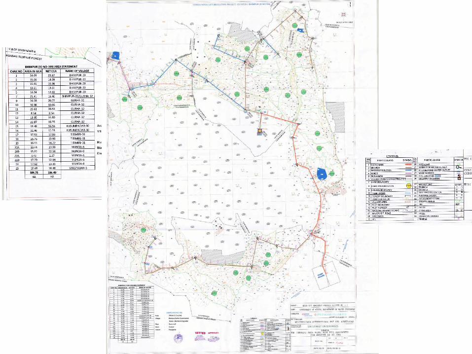
We request you to kindly provide a sample of an A0 size map file which will help us in estimating the SOW.
Enclosed
3 Section 1.4 Page 7 Details of map digitization, map preparation and data entry Ayacut maps with cultural details (approx.) a. A0 and A1 size maps‐‐‐‐ 107 ayacuts 1400 Th. Ha
We understand that there are 107 A0 and A1 size maps & total 107 ayacut maps total covering 1400 Th. Ha. Please confirm
As per tender document Section 1.4
4 Section 1.4 Page 7 Scanned files for ’a’ and ‘b’ above will be provided for digitization. For “c” A4 size plot maps will be provided with demarcation of small ayacuts and source of irrigation. The corresponding mouza maps (scanned files/shape files) will be provided.
Kindly provide the no. of mouza maps that are available in Shape format.
Refer tender document Page‐7, Section 1.4
5 Section 1.4 Page 7 Scanned files for ’a’ and ‘b’ above will be provided for digitization. For “c” A4 size plot maps will be provided with demarcation of small ayacuts and source of irrigation. The corresponding mouza maps (scanned files/shape files) will be provided.
Kindly confirm whether we need to digitize mouza maps in scanned files. If Yes, In what format are they currently available and what is the scale of these maps?
No digitisation of mouza maps
6 Section 1.4 Page 8 ORSAC will provide working space (with power/AC), computer system and software. Kindly confirm whether entire digitization to be done at ORSAC Premises
Yes
7 Section 1.2 Page 5 Land use/Land utilization mapping inside ayacuts using HR satellite data Worldview, Cadastral maps/ RoR and departmental data—(inputs will be provided by ORSAC)
Kindly confirm on, what all inputs will be provided by ORSAC.
As mentioned in section 1.2 of tender document
8 Section 1.2 Page 5 Land use/Land utilization mapping inside ayacuts using HR satellite data Worldview, Cadastral maps/ RoR and departmental data—(inputs will be provided by ORSAC)
∙ Kindly clarify whether the Land use/Land utilization mapping is only for the area of ayacuts. ∙ We assume that georeferenced Scanned cadastral maps will be provided. Please confirm.
In Ayacuts yes
9 Section 1.2 Page 5 Land use/Land utilization mapping inside ayacuts using HR satellite data Worldview, Cadastral maps/ RoR and departmental data—(inputs will be provided by ORSAC)
Kindly clarify on what are the layers that needs to be captured from HR satellite data Worldview.
Standard level‐III LU/LC classification system of NRSC/TCPO.
10 Section 1.2 Page 5 Land use/Land utilization mapping inside ayacuts using HR satellite data Worldview, Cadastral maps/ RoR and departmental data—(inputs will be provided by ORSAC)
Kindly confirm on what departmental data will be provided by ORSAC. Should we need to link any data as attributes to the spatial features captured (digitized)?
As mentioned in section 1.2 of tender document YES
11 Section 1.2 Page 5 Development of Web based GIS System Components of Web‐GIS portal Development of thematic Maps
Kindly confirm on what kind of thematic Maps to be prepared and How many such thematic Maps needs to be prepared as a part of this project?
ORSAC will provide base maps, administrative maps and general infrastructure thematic maps. Vendor has to create Thematic maps relating to LU/LC maps of ayacut and maps to be digitisedby vendor.
12 Section 1.2 Page 6 Components of Web‐GIS portal Interactive Queries Reporting ∙ Kindly confirm on what type of Interactive Queries that are being expected by ORSAC. ∙ Please confirm on how many such reports needs to be developed. ∙ Please provide the sample report for our reference.
As per GoiPLUS gis.investodisha.org
13 Section 5.0 Page 30 SPECIFICATIONS FOR PLATFORM SOFTWARE & APPLICATION SOFTWARE Kindly provide the details of the server configuration and also give the details of other applications hosted on this server.
ESRI ArcGIS Standard Server ver.10.3 or Intergraph geospatial server available with ORSAC with existing application running • Database (RDBMS) Server: Oracle standard (latest version)
14 Section 4.4 Page 28 WARRANTY AND ON‐SITE SUPPORT The IP shall facilitate on‐site deployment of 2 (two) senior professionals during development and for maintenance support for a period of 1 (one) years from the date of commissioning to be on call.
Kindly provide the details of the activities that need to be done during the WARRANTY AND ON‐SITE SUPPORT period for 1 year by 2 senior professionals at ORSAC premises.
Time to time data updating/ integration and changes in query development.
15 Section 5.0 Page 30 SPECIFICATIONS FOR PLATFORM SOFTWARE & APPLICATION SOFTWARE We understand that vendor is not required to procure / commission any hardware or any COTS software as a part of the project during WARRANTY AND ON‐SITE SUPPORT period
Yes
16 General General Kindly provide the below mentioned sample maps which helps in estimating the scope of work.a. A0 and A1 size mapsb. A2 size mapsc. A3/A4 size maps
Enclosed
17 General General Kindly provide the details of acceptance criteria for the digitized data.
As per tender document.
E. Name of the Bidder- Cyient Limited SL. NO
SEC. NO. PAGE NO. Excerpt of TENDER Clause QUERY REPLY
1 RFP Section 1.2, Project Back ground, Point no 3
5 Site maps with image on background 1. Which image do we need to use as a background for the site maps?
Available in public domain
2. Is ORSAC expecting Worldview ortho to be populated with site maps? If yes, the bidder need to perform ortho generation? Please confirm.
NO
2 RFP Section 1.2, Project Back ground, Point no 5
5 Infrastructure datasets 1. Can you please elaborate what are the features cover under Infrastructure datasets?
irrigation infrastructure/ canal assets, datasets, RoR and benificiary etc.
3 RFP Section 1.4, Details of map digitization, map preparation and data entry
5 Details of map digitization, map preparation and data entry 1. We assume Ayacut maps contains details of Landuse, Site, Infrastructure, Canals, irrigated/Cultivated lands and these features need to be captured from Geo‐referenced Ayacut maps. Please confirm.
Ayacut maps does not include landuse.
4 RFP Section 1.2, Work Component of Vendor, Point no A
5 Map digitization, attribute data entry and Map preparation of ayacuts.(refer section 1.4) 1. Does ORSAC provide the GIS database schema/ Data model or expecting the Bidder to develop the data model?
Model to be developed as per ORSAC suggestion.
2. What are the features/map layers and type of geometry that need to capture?
As per tender document.
3. How many attributes will be there for ayacut maps?
Refer D 2
5 RFP Section 1.2, Work Component of Vendor, Point no B
5 Land use/Land utilisation mapping inside ayacuts using HR satellite data Worldview, Cadastral maps/ RoR and departmental data—(inputs will be provided by ORSAC)
1. We assume HR Worldview images are acquired and supplied by ORSAC, please confirm.
Yes
2. How many HR Worldview Scenes will cover total Ayacut area and what would be the total area of imagery need to be processed?
Odisha state Ayacut area details as per tender document.
3. What is the type of scenes (PAN/MSS) and resolution of the images?
0.5 m
4. What is the product type for input Worldview data (Basic/OR2A)?
WV‐MX data
5. Is the Worldview data supplied in Stereo/Mono? Both 6. What is the processing involved? Is the bidder required to perform Triangulation, Pan sharpening, ortho generation etc.?
No orthogeneration.
7. If the Triangulation is required, does it required to use GCPs? If yes, what is the source of GCPS?
No triangulation
8. Is ortho processing required, if yes, what is the source of DEM?
No orthogeneration.
9. What is the level of information that is expected to capture under Land use/ Land utilization mapping?
Standard level – III LU/LC classification
6 RFP Section 1.2, Work Component of Vendor, Point no C
5 Development of Web based GIS System Components of Web‐GIS portal Development of thematic Maps
1. What are the themes ORSAC is expecting to generate?
As explained in section A,B,C above
7 RFP Section 1.3, Project Requirements
6 Preparation of ayacut and other resorce/infrastructure maps (as mentioned in 1.2 above) to be developed using ORSAC inputs
1. Is it possible to list the proposed inputs to be supplied by ORSAC including the existing infrastructure?
Spatial and attribute data will be provided Refer to enclosed maps
8 RFP Section 1.4, Details of map digitization, map preparation and data entry
7 a. A0 and A1 size maps‐‐‐‐ 107 ayacuts 1. It is mentioned that there are a total of 20,259 Ayacuts comprising of A0, A1 , A2, A3 and A4 size maps. We assume that the absolute number of maps are equivalent to the number of Ayacuts i.e, 20259. In other words, 1 Ayacut will cover in 1 map sheet of various sizes, Please confirm.
Refer to page 7, section 1.4 of tender document, It is approximate number of ayacuts as per info of WR Dept, Odisha. Ayacuts are covered under one sheet. A single map containing one ayacut will be provided
b. A2 size maps‐‐‐‐ 4152 ayacuts 2. What is the scale of information plotted in the Ayacut maps.
20 3.3.1 PAYMENT MILESTONES 1. Request you to consider batch wise delivery and acceptance of database (digitization & geo‐referencing) monthwise and pro‐rata payment release @ 10% for each batch.
As per tender document.
2. Request you to consider batch wise delivery and acceptance of development of GIS database
As per tender document.
monthwise and pro‐rata payment release @ 10% for each batch.
3. OR Can Payment milestones for stage 1 (40%) and 2 (20%) be considered as one activity as mentioned in the project timeline as Development of GIS database (4 months after SRS).
As per tender document.
4. From the given payment milestones, it looks like 60% of the total project cost has been considered for GIS database development and rest 40% for application development. May we request for separate payment stages for GIS Database development and Web Portal development. In that case, 40% of the project cost towards application development can be released at the following stages ‐
As per tender document.
a. 10% on submission and acceptance of SRS As per tender document. b. 20% on UAT and submission of test reports to ORSAC
As per tender document.
c. 4c. 10% on Installation & commission in the State Data Center
As per tender document.
10 RFP Section 1.2, Work Component of Vendor, Point no C
5 Development of Web based GIS System Components of Web‐GIS portal 1. Does Web interface need Spatial editing option as well or its limited to Viewing, Querying and basic GIS functionalities (Zoom, Pan, measure, print etc.,)
Refer to C‐12
2. Please elaborate on Data attachment. Is this related to file attachments to the GIS feature?
Yes
3. Please share no of reports. Refer to C‐12 4. How many interactive queries are expected and what is the level of complexity.
Refer to C‐12
11 RFP Section 2.2.3, 14 Commercial Proposal In third point total price of software is requested and in other areas it was mentioned that ORSAC will provide necessary software, hardware. Can we consider this point as software development cost?
Total cost including all activities as per tender documents
12 General How many concurrent users are expected to access this application?
25‐30
13 General Cyient assume that the base map data will be provided by ORSAC, Please confirm.
Yes
14 General Cyient assume that the domain registration will be taken care by department, Please confirm.
Vendor responsibility
15 General Cyient assume that the department will bear the cost of SSL certification, Please confirm.
No
16 General Can vendor propose an alternate schedule or need to adhere with the schedule proposed by ORSAC.
As per tender document.
17 General It appears that the time given for SRS is not sufficient and is it possible for ORSAC to increase this by another 15 Days at least?
As per tender document.
18 General Cyient assume that there is no survey component involved, Please confirm.
No survey
19 General Can vendor propose additional software if required. We assume department will bear the cost for these additional software, please confirm.
Yes
20 General Can you please share sample Ayacut maps? Enclosed
F. Name of the Bidder- IEISL SL. NO
SEC. NO. PAGE NO. Excerpt of TENDER Clause QUERY REPLY
1. 1.2, Point B 1 Land use/Land utilisation mapping inside ayacuts using HR satellite data Worldview, Cadastral maps/ RoR and departmental data—(inputs will be provided by ORSAC)
I. We assume that all the Satellite images will have Referencing System/ Coordinates or Ortho rectified which will be necessary for Georeferencing for other input maps.
Yes
ii. In case, Geo‐referencing of satellite images also to be performed, we request ORSAC to provide GCPs or reference source images for the same. Request to kindly provide clarity and confirm.
GCP collection not required
2. 1.2 2 Land use/Land utilisation mapping inside ayacuts using HR satellite data Worldview, Cadastral maps/ RoR and departmental data—(inputs will be provided by ORSAC)
Kindly provide the following details about the deliverables or output map:
Cadastral scale
1. Resolution Cadastral scale 2. Data Layers in Landuse Land Cover Cadastral scale 3. Accuracy Cadastral scale 4. Scale Cadastral scale Also, kindly confirm that the RoR linking is whether in bidder’s scope.
Digital cadastral data and RoR will be provided.
Kindly specify the departmental data and its usage in Geo‐database.
Refer D‐2
3. 1.2 C 5 Development of thematic Maps We request to kindly provide the list of thematic maps which needs to be prepared.
Refer C ‐11
We understand that the thematic maps will be displayed in web portal for visualization purpose. Please confirm whether the thematic maps need to be delivered as output in particular format.
outputs are not for visualisation and can be used in integration and interactive queries.
4. 1.2 C 5 Data in Layers, Asset/ Database of ayacut/canal infrastructure Request to confirm these assets Database of ayacut/canal infrastructure will be captured from the Ayacut maps as it is or needs to be updated from the provided Satellite Image.
Assets datasets will be provided. All canal networks to be mapped.
5. 1.3 6 Data search by integrating irrigation and agricultural activity data We request to kindly elaborate this requirement. Example‐ agricultural area under irrigation or plots under water supply by primary/ secondary canal distributory system.
6. 1.2 5 Dataset generation Kindly elaborate your requirement of GIS Database Generation, i.e. the layers required to be prepared along with its attributes.
Refer to A‐2
7. 1.2 5 HR satellite data Worldview Kindly clarify: ∙ Satellite Imagery to be provided will be WorldView 2, WorldView 3 or WorldView 4.
World view II, cartosat 2 etc.
∙ Type of Satellite Imagery i.e. Panchromatic or Multispectral.
MX data
8. 1.3 6 Data search by integrating irrigation and agricultural activity data We understand that for irrigation and agricultural activity data analysis socio‐economic data is also required. If yes, we request ORSAC provide the same for better analysis. Kindly confirm
inputs will be provided
9. 3.2 Development of GIS database 4 months We understand that the 4‐month duration shall start after completion of milestone of Award of Contract and Team mobilization and System Requirement Specification.
Yes
10. 4.1 27 USER ACCEPTANCE TEST Digitisation, georeferencing and GIS database will be developed as per ORSAC quality standard and acceptance.
We request to kindly to specify the ORSAC quality standard and acceptance criteria for database deliverables.
As per tender document.
11. 1.2, C 5 PROJECT BACKGROUND Development of Web‐GIS Database structure/WEB GIS Interface
Please provide information of expected data size/data load on the envisaged system.
As per tender document.
12. 1.2, C 6 PROJECT BACKGROUND Data Storage
Please provide information of any archival policy of the data. Please specify in terms of time duration of data storage.
As per tender document.
13. 1.2, C 6 PROJECT BACKGROUND Reporting
Please provide information on number of reports and their formats.
Refer C‐12
14. 1.2 6 The web‐portal structure and components will be in line of GOiPLUS developed by the centre and can be accessed at gis.investodisha.org
The web‐portal design structure is understood from GOiPLUS. Please specify the modules/components of the envisaged system. Request to provide detailed functional requirements and Non‐Functional Requirements respective to each module/component of the envisaged system.
As discussed in Pre bid meeting. Modules like GoiPLUS.
15. 1.3 (a) 6 PROJECT REQUIREMENTSApplication Development: Rapid loading of the online system/website and easy navigation between pages is imperative. Pages and features should be compatible with potentially limited bandwidth available with the users.
Please specify the type of users (internal/external) who will be accessing the envisaged system. Also, what will be the average number of users of the system?Please provide information.
Refer to E‐12 above
16 1.3 (b) 6 PROJECT REQUIREMENTS Application Development: Rapid loading of the online system/website and easy navigation between pages is imperative. Pages and features should be compatible with potentially limited bandwidth available with the users.
Please specify expected response time of the web pages.
As per GoiPLUS
17. 1.3 (c) 7 PROJECT REQUIREMENTS The online system should be flexible to accommodate new/additional pages and should allow for changing the interface template as and when required by the Authority.
Please provide information on the frequency of update of the web portal.
after development and operationalisation, once in a month.
18. 1.3 (f) 7 PROJECT REQUIREMENTS The Developer to undertake uploading, updating and maintaining the content/ information on the online system. The interaction and integration of the proposed online system and the other systems shall be ensured.
Please specify the integrating systems with the envisaged system.
with OSDI
19. 4.1 27 PROJECT REQUIREMENTS UAT: After completion of development, final testing will be carried out by the Developer’s Quality Assurance team. The detailed QA report to be shared with for final testing of the system.
It is understood that the system testing will be done by developer’s QA team. Please provide information if there is a requirement of resource (person) for helping out in UAT with ORSAC team other than the documents provided by successful bidder. Kindly Confirm.
As per NIC standard
20. 4.3 TRAINING 28 Training is to be imparted to the selected officials. The training venue, projector & other required equipment will be provided by the ORSAC.
Kindly share the detailed training plan in terms of scope, number of officials, training sessions and duration.
Refer A‐6
21. 1.3 6 Project Requirements The system should be designed and developed in such a way that it will be foundational for future enhancements.
RFP is silent about accommodating the additional requirement (if any) comes during the requirement phase considering the overall project perspective. Hence, it is recommended to keep the provision to accommodate additional requirement (if any) as per change request mechanism.
As per tender document.
22 1.3 7 Project Requirements Service Support and Maintenance This support can be extendable by additional 2 years, subject to satisfactory performance of the Developer and mutually agreed terms & conditions.
It is recommended to release separate Purchase Order for Additional 2 years Solution Implementation Maintenance Schedule as it will involve additional resource man‐month rate.
As per tender document.
23. 1.3, point m 7 The development work to be undertaken in ORSAC premises. The vendor has to place developer to work at ORSAC (mandatory) from the date of acceptance of work order till completion within a month in consultation with project coordinator and incharge
We understand that the entire Web Application Development activities will be performed at ORSAC premises only, however, GIS Database Development and Digitization work can be done at backend office. We request ORSAC to kindly confirm the expected number of developers needs to be deployed onsite.
As per tender document.
24 3.2 20 Project Schedule It is understood from RFP that the Application Development and Data Development activities are to be carried out in 8 months’ duration. Looking at the scope of integration, we request you to kindly extend it to 12 months.
As per tender document.
25 1.4 7 Details of map digitization, map preparation and data entry Scanned files for ’a’ and ‘b’ above will be provided for digitization. For “c” A4 size plot maps will be provided with demarcation of small ayacuts and source of irrigation. The corresponding mouza maps (scanned files/shape files) will be provided
Request you to provide the following details about the Static/Secondary maps provided by ORSAC. 1. Total Volume of mouza maps. 2. Resolution and Scale of Maps
Mouza maps will be provided in digital format
26 2.5.1 16 EVALUATION OF TECHNICAL PROPOSALS Evaluation of the technical proposal shall be conducted by the evaluation committee and shall be based on the past experience, technical capabilities, suggested approach & methodology for proposed assignment.
The parameter of evaluation of the technical proposal in the marking system is contradictory. As, there is no marking for approach & methodology. Request to kindly include the approach & methodology parameter in the Evaluation Criteria.
As per tender document.
27 6.1.2 GF‐2 32 BIDDER’S UNDERTAKING STATEMENT 2. –Ditto‐ digital word/excel format – Total Pages ………………… 3. Technical Proposal consisting of the following documents in digital pdf format a. …………… Total pages ……………….
Kindly specify if the bidder needs to put total pages of each section of the proposal in the gaps provided in the format of Undertaking Statement. Also, specify the required information expected in response to the term ditto.
Yes, Total pages enclosed
28 General Please clarify the SLA, Escalation and approval mechanism.
29 3.3.3 PENALTIES 21 Due to the negligence/ inabilities on part of the vendor, a penalty of 0.5% will be charged for each week of delay from the payment associated
We request modify the clause as below:In the event of the vendor is unable to meet the specified delivery milestones due to the negligence/ inabilities on part of the vendor, a penalty of 0.25% will be charged for each week of delay from the payment associated
As per tender document.
30 3.6.2 Performance Bank Guarantee
Within 15 (fifteen) days of Notification of “Award of the Work”, the selected bidder shall furnish Performance Security to ORSAC @ 20% of the total value of quoted bid
We request modify the clause as below: Within 15 (fifteen) days of Notification of “Award of the Work”, the selected bidder shall furnish Performance Security to ORSAC @ 10% of the total value of quoted bid
As per tender document.
G. Name of the Bidder- Stesalit Systems Limited 1 2.3.2 (PQ) 13 The bidder should be a profitable vendor
and should have an annual financial turnover of at least INR 2 (two) crore in each of the last 3 (three) financial years (2015‐16, 2014‐15 and 2013‐14)
Please revise as below ‐ The bidder should be a profitable vendor and should have an average annual financial turnover of at least INR 2 (two) crore in each of the last 3 (three) financial years (2015‐16, 2014‐15 and 2013‐14)
Refer to B‐2
2 2.5.1 (A3) 16 Experience in completion of GIS/ Web GIS based Application Development projects for Govt. Departments, Public Sector Undertakings and Large Corporates. Marking will be given on the basis of work done and experience as mentioned in 2.3.2. MAX SCORE: 70
Please clarify scoring. What is the distribution of 70 marks? How many marks per project?
Experience in completion of GIS/ Web GIS based Application Development projects for Govt. Departments, Public Sector Undertakings and Large Corporates. Two webportal developed‐‐its content, data volume, landing page, data structure, portal paging, sequencing, query options, visibility, graphics, cosmetics etc.
3 1.4 7 Scanned files for ’a’ and ‘b’ above will be provided for digitization. For “c” A4 size plot maps will be provided with demarcation of small ayacuts and source of irrigation. The corresponding mouza maps (scanned files/shape files) will be provided.
Will the vendor be required to bear the cost of scanning? Also how soon will all the maps be handed over to project team (A3/A4) ?
NO. All scanned files of ayacuts (major, medium,minor) will be handled over immediately after tender selection finalised.
4 3.3 20 The payment will be based on the delivery milestones. On successful completion of the milestone the vendor shall submit the deliverables to ORSAC for verification. ORSAC shall verify the deliverables submitted by the bidder within 10 days of receipt of the same and shall issue acceptance. On successful acceptance of the deliverables, the vendor shall raise invoice to ORSAC along with copy of the acceptance letter of the deliverables issued by ORSAC.
As the existing clause of payment of any part refers to the sucessful completion follwed by approval, this may create a fund crisis for day to day activity. Can the billing be done on the basis of approved data month wise or maybe the completion & acceptance of 50% data of each part?
As per tender document.
5 1.2 5 & 6 Development of Web based GIS System Components of Web‐GIS portal
Will this web application be accesible publicly or will it be accessible through only intranet enviornemnt? Will there be a need to implemet any spatial editing feature on the web?
Both for official use and public view.
6 5 30 Specification for Platform Software The Application is to be designed As the application needs to be in line with existing GOiPlus, which is developed in ESRI so in that case the web portal also should be developed with ESRI platform. Please confirm this.
As per tender document.
H. Name of the Bidder- Spatial Planning & Analysis Research Center, Bhubaneswar SL. NO
SEC. NO. PAGE NO. Excerpt of TENDER Clause QUERY REPLY
1 2.3.2 (B.1)‐Technical Eligibility Criteria
13 "Past experience in development of GIS Work of > 1 crore and Web GIS based Portal Development of value not less than Rs.15 lakhs in last 5 (five) years
Request for modification i.e. "Past experience in development of GIS work of > 50 lakhs and Web GIS based Portal/Application Development of value not less than 15 lakhs in last 5 years"
As per tender document.
2 2.3.2 (B.2)‐Technical Eligibility Criteria
13 "Minimum two operational Web GIS based Portal Development Projects" Can we demonstrate"Web GIS based Portal/Application Devlopment projects" with respective work order/relevant documents
As per tender document.
I. Name of the Bidder- Egis India Consulting Engineers Pvt Ltd SL. NO
SEC. NO. PAGE NO. Excerpt of TENDER Clause QUERY REPLY
12 & 14 Page 12: Demand Draft from any Nationalized Bank Page 14: All proposals submitted in response to the Tender notice must be accompanied by an Earnest Money Deposit (EMD) of Rs.200000/‐(Rupee two lakh only) in the form of a Bank Demand Draft drawn in favor of Odisha Space Applications Centre, payable at Bhubaneswar, Odisha from any scheduled commercial bank and payable at Bhubaneswar, Odisha.
Please clarify, should the EMD be submitted as a DD from a nationalized bank or a scheduled commercial bank?
EMD in DD from a nationalised bank
2 2.3.2 Prequalification Criteria
13 Past experience in development of GIS work of > 1 crore and Web GIS based Portal Development of value not less than Rs.15 lakhs in last 5 (five) years.
We understand that any GIS work worth more than and experience of web portal development worth at least 15 lacs can be shown as maximum of two separate experiences and be considered. Please confirm.
As per tender document.
3 2.3.2 Prequalification Criteria
12 The bidder should have made a payment of Rs.2,000/‐ (Rupees five thousand only) for the cost of the tender document
Please clarify, tender fee is Rs. 2000/‐ or 5000/‐? The bidder should have made a payment of Rs.2,000/‐ (Rupees two thousand only) for the cost of the tender document
4 5.0 Specifications fr platform software and application software
30 The Application is to be designed and developed for the following operating environment We understand that the software will be provided to the selected bidder and the price to be quoted must be excluding the software costs. Please confirm.
No Software procurement by bidder
5 4.3 Training Regarding training The details provided regarding training are not clear. Please clarify, what are the aspects in which training is to be provided?
Refer A‐6
6 General Should the system have facility for concurrent spatial data updations/additions?
Spatial updation module to be added later
7 1.2 PROJECT BACKGROUND
5 Components of Web‐GIS portal ‐ Data Attachment
What is meant by Data attachment? Is it the media (image, video, pdf) that may be attached to a location? Please clarify.
Yes also RoR and other tabular data
J. Name of the Bidder- PIXEL SOFTEK PVT. LTD., BENGALURU
1 2.3.2 Pre‐Qualification Criteria
13 4) The Organisation should be registered under Indian Companies Registration Act, 1956 and should have their registered office in Odisha
With reference to having registered office in Odisha, we request you to make it flexible by Accepting declaration by Bidder indicating setting up of an office in Odisha within 30 days of Contract award
Refer A‐5
2 6.3.2 CF‐2 Format for Commercial Bid
50 Digitisation, georeferencing, database creation and webportal creation as per the tender specification Provision of support (as per tender) for a period of 1 year from the date of installation and commissioning of the application at ORSAC/SDC)
Kindly clarify, whether quote for support to be mentioned separately or to be combined with development cost
NO
K. Name of the Bidder- CyberSWIFT SL. NO
SEC. NO. PAGE NO. Excerpt of TENDER Clause QUERY REPLY
1 Sl no. 4‐ Local Office 13 The Organisation should be registered under Indian Companies Registration Act, 1956 and should have their registered office in Odisha
You are looking only local company or who have registered office in odisha but as per your work nature some other company also qualified. So we would request to you for more comparative bidding process please allow out side of odisha company for bidding the tender. Some how we are getting the project we are also giving a declaration of setting up Local office in Odisha.
Refer A‐5
L. Name of the Bidder- Global Business Solution SL. NO
SEC. NO. PAGE NO. Excerpt of TENDER Clause QUERY REPLY
1 Page No.22 Performance security to ORSAC @ 20% of the total value of quoted bid Is It possible to reduce change to 5% PBG of total value of the project as 20% PBG of total value is very high value?
As per tender document
2
Page No.07 A0 (107 ayacuts), A2 (4152 ayacuts), A3 ‐ A4 (16000 ayacuts). Total map : 20259 Please clarify the following points: 1. Boundary co ordinates are available on ayacuts map for Geo referencing?
Yes
2. How many layers to be digitized from ayacuts map?
Around 6‐7
3 Page No.30 ESRI Arc GIS standard server ver. 10.3 or intergraph geospatial server available with ORSAC with existing application running.
It means vendor can develop the web application in any platform as per their expertise lavel. Please clarify.
ESRI ArcGIS Standard Server ver.10.3 or Intergraph geospatial server available