23
East Hampshire District Council CORE STRATEGY ISSUES & OPTIONS Background paper for settlement hierarchy Spring 2008 (Updated May 2012)

East Hampshire District Council
CORE STRATEGY ISSUES & OPTIONS
Background paper for settlement hierarchy
Spring 2008 (Updated May 2012)

1
EAST HAMPSHIRE DISTRICT
Core Strategy “Issues and Options” Background Paper Settlement Hierarchy
1. Introduction 1.1 One of the key issues for the Council’s Core Strategy will be to identify
broad locations for future development. Options for such a spatial strategy are set out in the main Issues and Options Consultation Paper. They are based on a settlement hierarchy in order to promote a sustainable development pattern by encouraging close links between housing, jobs and services thereby reducing the need to travel especially by car.
1.2 This background paper has been published to accompany the main Issues
and Options Consultation Paper. It will be updated as progress on the Core Strategy continues and will provide the “evidence base” for supporting and justifying the spatial strategy for the location of new development in East Hampshire.
1.3 The traditional approach towards establishing a settlement hierarchy has
been to examine the extent to which key services and facilities are available within each town and village and using this to rank the settlement’s sustainability to accommodate further development. It is now appreciated that whilst this approach has been helpful it fails to recognise the function that towns and villages may have in relation to other settlements. For example, a larger village may act as a local service centre for nearby smaller villages and this might warrant further growth.
1.3 The paper briefly reviews Government guidance and other relevant
literature to set the policy context. It continues with an explanation of the methodology used to establish a settlement hierarchy. The data used to establish the hierarchy is presented in the form of a matrix (Appendix 1) which allows the easy comparison between settlements. Finally, the settlements are ranked based on the level of access to services and facilities, including higher level services and facilities by public transport, and function (Appendix 2). The hierarchy of settlements will guide the broad location of new development. Additionally, it may identify what extra facilities are required in a specific location especially in a rural area.
EAST HAMPSHIRE SETTLEMENT ANALYSIS AND HIERARCHY BACKGROUND PAPER

2
1.4 Comments are invited on the contents of this document and should be sent to:
The Planning Policy Team East Hampshire District Council Council Offices Penns Place Petersfield, GU4 31EX
Or emailed to: ldf@ easthants.gov.uk by Monday 31 March 2008 2. National and Regional Guidance
National Guidance 2.1 The principle of sustainability is now well established in Government
guidance. Its Planning Policy Statements notably PPS1: Delivering Sustainable Development, PPS3: Housing and PPS7: Sustainable Development in Rural Areas and PPS13: Transport require new development to be in accordance with sustainable options.
2.2 In particular, new development should be focused in towns to maximise
accessibility to facilities and services by means other than by the car. In rural areas, most new development should be focused in or near local service centres which should be identified in the development plan. Some limited development should be allowed for at other rural settlements to meet local business and community needs and to maintain the vitality of these communities especially when remote from, or have poor public transport links with service centres.
2.3 The settlement analysis and the establishment of a hierarchy are important if the Government’s guidance on sustainable development is to be implemented. Regional Guidance
2.4 The most up to date Regional guidance is set out in the draft South East
Plan 2006-2026, published in March 2006 and likely to be adopted in 2008. The Panel’s recommendations were published in August 2007 following an Examination in Public during the winter of 2006/7.
EAST HAMPSHIRE SETTLEMENT ANALYSIS AND HIERARCHY BACKGROUND PAPER

3
2.5 Sustainable development is a central theme of the Plan. It reinforces
previous Regional guidance by focusing future development in and around urban areas to make the best use of land and to develop more sustainable patterns of development and lifestyles. The concept of hubs as centres of economic activity and transport services is considered applicable at all levels from regional to local service provision in rural areas.
2.6 Small rural or ‘market’ towns therefore have a key part to play in the
economic and social functioning of the region. The Regional guidance recognises that they often act as a focal point for trade and services for a rural hinterland. Under the strategy of the South East Plan they will not be the main focus for development but will still need to foster economic vitality and appropriate development including the provision of affordable housing. Their local character and identity should be reinforced and enhanced.
2.7 The Panel considered that council’s Local Development Frameworks
(LDFs) should take account of both the function and the size of the market town which would generally be up to about 20,000 population.
2.8 The guidance recognises that villages form an important part of the
network of settlements in the Region and are often the subject of development pressures or stagnation, in some cases resulting in the loss of services or changing community structure. Limited small-scale development can help meet specific local housing, business and service needs of individual rural settlements. In some cases, development may serve a group of villages.
2.9 The Panel endorsed the requirement to plan positively for villages, but
recognised that not all villages are necessarily suitable for growth. It recommends that Policy BE6 (Village Management) should include criteria that would assist in identifying those villages where additional development would be appropriate. This may mean defining a settlement hierarchy. The criteria suggested are the functions performed by the village (especially in serving an adjoining or cluster of villages), its accessibility, and the need to protect or extend key local services.
3. Methodology for the production of the East Hampshire Settlement
Hierarchy 3.1 The methodology used to establish the settlement hierarchy builds upon
that previously used in the preparation of the District Local Plan: Second Review (adopted March 2006). The Local Plan emphasises the need for sustainable development and the location of new development to 2011 is
EAST HAMPSHIRE SETTLEMENT ANALYSIS AND HIERARCHY BACKGROUND PAPER
4
guided by the hierarchy of settlements in East Hampshire reflecting their access to services and facilities.
3.2 A previous settlement analysis and hierarchy were considered at the Local
Plan Inquiry held during the winter of 2003/4. Concerns were expressed by objectors that the accessibility matrix was too simplistic and omitted some important services and facilities. It also elevated satellite settlements to a higher level than they deserved and paid too little regard to landscape constraints such as the AONB.
3.3 The Inspector accepted that the matrix could have been refined and made
more comprehensive. Nevertheless, it did clearly indicate the most accessible settlements as a starting point for the distribution process. This background paper and the settlement analysis it contains seeks to address the issues raised at the Inquiry, notably the weighting of key facilities and the accessibility/proximity of satellite settlements to the main settlement. It also identifies the function of each settlement in relation to others which was considered important by the Panel reporting on the South East Plan.
3.4 In undertaking the East Hampshire settlement analysis and constructing
the accessibility/land use matrix, account has been taken of the Government and Regional guidance summarised above. Also the methodology used by other local planning authorities particularly those analyses that have been accepted following independent examination.
3.5 It is considered that the methodology used is sound and an appropriate
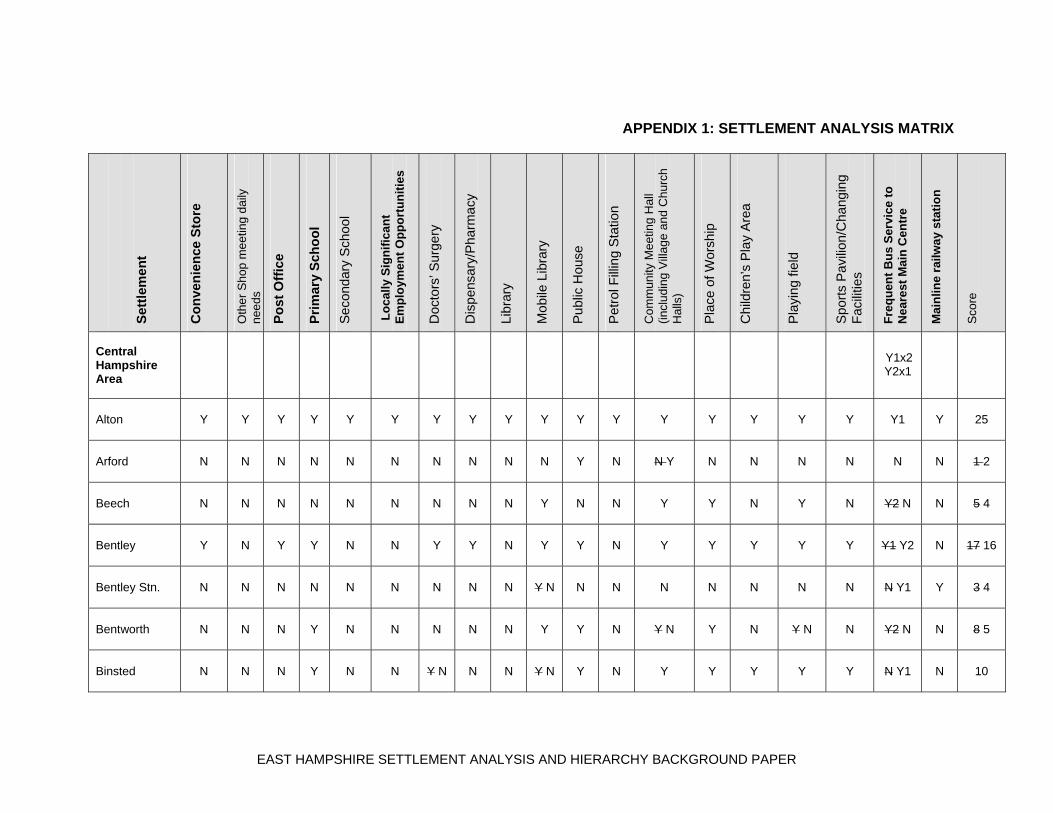
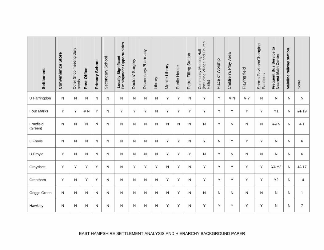
basis upon which to derive a settlement hierarchy. 3.6 The matrix of services and facilities set out in Appendix 1 was compiled
largely in September 2007 with the help of Parish Councils, together with site surveys. It is recognised that over time some services and facilities may inevitably be lost whilst others may be created. It is considered that access to a post office is important to the sustainability of a settlement. The assessment has therefore taken into account the closure of some rural post offices.
4. Settlement Analysis 4.1 Fundamental to the creation of a settlement hierarchy is the identification
of local service centres where development should be focused outside larger urban areas (PPS7: Sustainable Development in Rural Area para. 3). There is no guidance as to what constitutes a local service centre but PPS7 suggests they could be a country town, a large single village or a group of villages. This means that the settlement analysis should not only
EAST HAMPSHIRE SETTLEMENT ANALYSIS AND HIERARCHY BACKGROUND PAPER

5
identify access to local services and facilities but also the function of towns and villages.
4.2 Individual settlements have been analysed based on the range of services
and facilities they contain and their accessibility. To ensure a comprehensive analysis all readily identifiable settlements have been analysed, including those previously considered unsustainable and without a settlement policy boundary.
4.3 The services and facilities chosen are those considered necessary to
meet the day-to-day requirements of local residents. PPS1 provides guidance on this matter and states that development should support existing communities and contribute towards mixed communities ‘with good access to jobs and key services for all members of the community’ (para 5). These key services are set out later as being: ‘jobs, health, housing, education, shops, leisure and community facilities, open space, sport and recreation’ (paras 16 and 27 (v)).
4.4 The key services and facilities set out in PPS1 have been expanded for
the purpose of the East Hampshire settlement analysis. The matrix that forms Appendix 1 shows the extent to which the chosen services and facilities are available in each settlement. To overcome previous concerns a weighting has been applied to those which generally will need to be accessed daily and which otherwise could generate significant numbers of journeys by car. These are:
• convenience store • post office • primary school • local jobs • frequent bus service to nearest main centre • mainline railway station
The other facilities, such as a doctors’ surgery, will usually be used less frequently by local residents.
4.5 The scoring system used to allow the comparison of the settlements in
East Hampshire awards double points for the existence of a service/facility likely to be used on a daily basis as set out above, and a single point for the remainder.
5 Proposed Settlement Hierarchy 5.1 There are over 60 settlements in East Hampshire ranging from self-
contained towns of several thousand people to villages and small hamlets. The level of facilities and services in each settlement also varies from a
EAST HAMPSHIRE SETTLEMENT ANALYSIS AND HIERARCHY BACKGROUND PAPER

6
wide range of shops and other uses to individual shops and in some cases just a church. Generally, the more provision there is, especially of key services and facilities, the more sustainable the settlement is with less reliance on the use of private cars.
5.2 The settlement analysis matrix in Appendix 1 allows for a comparison to
be made between individual settlements and provides the basis for the identification of local service centres. Appendix 2 provides a ranking of settlements according to their current access to services and facilities. However, whilst the level of services and facilities within a settlement gives an indication of its sustainability it does not mean that additional growth is necessarily appropriate. To make such a judgement other factors need to be considered notably any landscape or environmental constraints.
5.3 The role the settlements have is further expanded and developed in the
draft Spatial Strategy set out in the Issues and Options Paper. This seeks to identify the strengths, weaknesses and constraints in relation to new development for each of the settlements in the hierarchy ranking. The Consultation Paper continues by seeking comments on the options for locating sustainable development and the most suitable strategy to achieve it. Market towns and local service centres
5.4 PPS7 seeks the identification of local service centres in rural areas where
development should be focused outside larger urban areas. They are not defined in the Government’s guidance but for the purpose of this assessment they are regarded as settlements that have a wide range of services and facilities to provide for the needs of the town or village and its rural area. The analysis indicates that there are three main groupings of local service centres in terms of access to services and facilities and the function the settlements perform:
• ‘market towns’ • large local service centres • small local service centres
Market towns
5.5 The criteria for ‘market towns’ is derived from the settlement analysis and
a judgement on the function and character of the settlements and their relationship with the rural areas they serve. To qualify as a market town it is considered that the settlement should provide all the key services and facilities and at least have:
EAST HAMPSHIRE SETTLEMENT ANALYSIS AND HIERARCHY BACKGROUND PAPER

7
• a population of more than 10,000 • a recognisable town centre • a wide range of shops including a large supermarket • significant designated employment areas • at least one secondary school • a sports centre and playing fields for organised games • high level medical facilities • a good variety of community facilities • good public transport links to higher level services
The market towns in East Hampshire are:
Alton Petersfield
The analysis confirms that Alton and Petersfield remain the most sustainable settlements in East Hampshire. They are easily recognisable as country market towns set in a rural landscape and have attractive historic centres. Both demonstrate a high degree of self-containment. They have a wide range of shops and other uses including schools, jobs and community facilities and have good public transport links to London. They act as ‘hubs’ providing commercial and community uses for their rural hinterlands. Large local service centres The large local service centres are high in the settlement ranking and are considered to be those that have a significant number of key services and facilities and at least have:
• a parish population of more than 5,000 • a good range of shops including a supermarket • significant local employment • a secondary school • public open space/playing fields • community facilities • a medical centre
The large local service centres are:
Horndean Liphook
Whitehill/Bordon Horndean has a population putting it in the market town category, but it lacks a country town character being a significant urban area on the District boundary
EAST HAMPSHIRE SETTLEMENT ANALYSIS AND HIERARCHY BACKGROUND PAPER

8
adjoining Waterlooville. The retail centre is separated from a large part of the residential area by the A3(M) and it has no mainline railway station, although bus services to Portsmouth and Havant are good. Liphook is a self-contained settlement which has all the key services and facilities. It has a good range of shops and a recognisable town centre. The mainline railway station provides access to London, Guildford and Portsmouth. Whitehill/Bordon is a largely self-contained military town with a good range of services although these are generally spread throughout the settlement. The future release of MoD land for development will provide the opportunity to consolidate and enhance the town’s role as a large local service centre. Small local service centres The criteria for identifying small local service centres include both a smaller population threshold and a lower provision of services and facilities. To be classified as a small local service centre the settlement should have a high number of key services and facilities and have at least:
• a population of 2,000 • a convenience store, post office and other shops • a primary school • some local employment • playing field/children’s play area • a pub • a community hall • a GP surgery
The small local service centres are:
Clanfield Liss Four Marks Rowlands Castle Grayshott
Clanfield is a large village with a good range of services and facilities and is close to the A3. It lacks a mainline railway station and secondary school. Four Marks is one of the larger villages and lies on either side of the A31 with a good bus service to Alton and Winchester. The settlement has a good range of services and facilities including a significant amount of local employment. Grayshott is a large village on the border of the District close to Farnham. It has a good range of services and facilities including most key services.
EAST HAMPSHIRE SETTLEMENT ANALYSIS AND HIERARCHY BACKGROUND PAPER

9
Liss includes the satellite settlements of West Liss and Liss Forest. It has a declining retail base but still retains most of the key services. A mainline railway station allows for services to London, Guildford and Portsmouth. Rowlands Castle is a well defined large settlement with an attractive village centre. It has a good range of local services and facilities including a mainline railway station. The villages The settlements listed above are considered to be the most sustainable in East Hampshire and warrant market town or local service centre status. The District contains a large number of smaller settlements especially in the rural area, which lack services and facilities and look towards the towns and larger villages to supplement their service provision. In the absence of good public transport their residents are largely dependent on private cars for trips to meet day-to-day needs. Some of these settlements may benefit from further growth to meet local needs or help to retain vulnerable services.
EAST HAMPSHIRE SETTLEMENT ANALYSIS AND HIERARCHY BACKGROUND PAPER
APPENDIX 1: SETTLEMENT ANALYSIS MATRIX
Set
tlem
ent
Co
nve
nie
nce
Sto
re
Oth
er S
hop
me
etin
g d
aily
ne
eds
Po
st O
ffic
e
Pri
mar
y S
cho
ol
Sec
onda
ry S
choo
l
Lo
cally
Sig
nif
ican
t E
mp
loym
ent
Op
po
rtu
nit
ies
Doc
tors
’ Sur
gery
Dis
pens
ary/
Pha
rmac
y
Libr
ary
Mob
ile L
ibra
ry
Pub
lic H
ouse
Pet
rol F
illin
g S
tatio
n
Com
mun
ity M
eet
ing
Hal
l (in
clu
ding
Vill
age
an
d C
hur
ch
Hal
ls)
Pla
ce o
f Wor
ship
Chi
ldre
n’s
Pla
y A
rea
Pla
ying
fiel
d
Spo
rts
Pav
ilion
/Cha
ngin
g F
acili
ties
Fre
qu
ent
Bu
s S
ervi
ce t
o
Nea
rest
Mai
n C
entr
e
Mai
nlin
e ra
ilway
sta
tio
n
Sco
re
Central Hampshire Area
Y1x2 Y2x1
Alton
Y
Y
Y
Y
Y
Y
Y
Y
Y
Y
Y
Y
Y
Y
Y
Y
Y
Y1
Y
25
Arford
N
N
N
N
N
N
N
N
N
N
Y
N
N Y
N
N
N
N
N
N
1 2
Beech
N
N
N
N
N
N
N
N
N
Y
N
N
Y
Y
N
Y
N
Y2 N
N
5 4
Bentley
Y
N
Y
Y
N
N
Y
Y
N
Y
Y
N
Y
Y
Y
Y
Y
Y1 Y2
N
17 16
Bentley Stn.
N
N
N
N
N
N
N
N
N
Y N
N
N
N
N
N
N
N
N Y1
Y
3 4
Bentworth
N
N
N
Y
N
N
N
N
N
Y
Y
N
Y N
Y
N
Y N
N
Y2 N
N
8 5
Binsted
N
N
N
Y
N
N
Y N
N
N
Y N
Y
N
Y
Y
Y
Y
Y
N Y1
N
10
EAST HAMPSHIRE SETTLEMENT ANALYSIS AND HIERARCHY BACKGROUND PAPER

Set
tlem
ent
Co
nve
nie
nce
Sto
re
Oth
er S
hop
me
etin
g d
aily
ne
eds
Po
st O
ffic
e
Pri
mar
y S
cho
ol
Sec
onda
ry S
choo
l
Lo
cally
Sig
nif
ican
t E
mp
loym
ent
Op
po
rtu
nit
ies
Doc
tors
’ Sur
gery
Dis
pens
ary/
Pha
rmac
y
Libr
ary
Mob
ile L
ibra
ry
Pub
lic H
ouse
Pet
rol F
illin
g S
tatio
n
Com
mun
ity M
eet
ing
Hal
l (in
clu
ding
Vill
age
an
d C
hur
ch
Hal
ls)
Pla
ce o
f Wor
ship
Chi
ldre
n’s
Pla
y A
rea
Pla
ying
fiel
d
Spo
rts
Pav
ilion
/Cha
ngin
g F
acili
ties
Fre
qu
ent
Bu
s S
ervi
ce t
o
Nea
rest
Mai
n C
entr
e
Mai
nlin
e ra
ilway
sta
tio
n
Sco
re
Blackmoor
N
Y N
N
Y
N
Y
N
N
N
Y
N
N
Y
Y
Y
N
N
N
N
9 8
Blacknest
N
N
N
N
N
Y
N
N
N
N
Y
N
N
N
N
N
N
N Y1
N
3 5
Bramshott
N
N
N
N
N
N
N
N
N
Y
N
N
N
Y
N
N
N
N
N
2
Bucks Horn Oak
N
N Y
N
N
N
N
N
N
N
Y N
Y
Y
N
N
N
N
N
Y1
N
4 5
Buriton
N
N
N Y
Y
N
N
N
N
N
Y
Y
N
Y N
Y
Y
Y
Y
Y2
N
10 11
Chawton
N
N
N
Y
N
Y
N
N
N
Y
Y
N
Y
Y
Y
Y
Y
Y2
N
12
East Meon
Y
N
Y
Y
N
N
N
N
N
Y
Y
N
Y
Y
Y
Y
Y
Y2
N
14
Empshott
N
N
N
N
N
N
N
N
N
N
N
N
Y
Y
N
N
N
N
N
2
L Farringdon
N
N
N
N
N
Y
N
N
N
Y N
Y
N
N
N
N* Y
N* Y
N
N
N
4 5
EAST HAMPSHIRE SETTLEMENT ANALYSIS AND HIERARCHY BACKGROUND PAPER
Set
tlem
ent
Co
nve
nie
nce
Sto
re
Oth
er S
hop
me
etin
g d
aily
ne
eds
Po
st O
ffic
e
Pri
mar
y S
cho
ol
Sec
onda
ry S
choo
l
Lo
cally
Sig
nif
ican
t E
mp
loym
ent
Op
po
rtu
nit
ies
Doc
tors
’ Sur
gery
Dis
pens
ary/
Pha
rmac
y
Libr
ary
Mob
ile L
ibra
ry
Pub
lic H
ouse
Pet
rol F
illin
g S
tatio
n
Com
mun
ity M
eet
ing
Hal
l (in
clu
ding
Vill
age
an
d C
hur
ch
Hal
ls)
Pla
ce o
f Wor
ship
Chi
ldre
n’s
Pla
y A
rea
Pla
ying
fiel
d
Spo
rts
Pav
ilion
/Cha
ngin
g F
acili
ties
Fre
qu
ent
Bu
s S
ervi
ce t
o
Nea
rest
Mai
n C
entr
e
Mai
nlin
e ra
ilway
sta
tio
n
Sco
re
U Farringdon
N
N
N
N
N
N
N
N
N
Y
Y
N
Y
Y
Y N
N Y
N
N
N
5
Four Marks
Y
Y
Y N
Y
N
Y
Y
Y
N
Y
Y
Y
Y
Y
Y
Y
Y
Y1
N
21 19
Froxfield (Green)
N
N
N
N
N
N
N
N
N
N
N
N
N
Y
N
N
N
Y2 N
N
4 1
L Froyle
N
N
N
N
N
N
N
N
N
Y
Y
N
Y
N
Y
Y
Y
N
N
6
U Froyle
Y
N
N
N
N
N
N
N
N
Y
Y
Y
N
Y
N
N
N
N
N
6
Grayshott
Y
Y
Y
Y
N
N
Y
Y
Y
N
Y
N
Y
Y
Y
Y
Y
Y1 Y2
N
18 17
Greatham
Y
N
Y
Y
N
N
N
N
N
Y
Y
N
Y
Y
Y
Y
Y
Y2
N
14
Griggs Green
N
N
N
N
N
N
N
N
N
N
Y
N
N
N
N
N
N
N
N
1
Hawkley
N
N
N
N
N
N
N
N
N
Y
Y
N
Y
Y
Y
Y
Y
N
N
7
EAST HAMPSHIRE SETTLEMENT ANALYSIS AND HIERARCHY BACKGROUND PAPER

Set
tlem
ent
Co
nve
nie
nce
Sto
re
Oth
er S
hop
me
etin
g d
aily
ne
eds
Po
st O
ffic
e
Pri
mar
y S
cho
ol
Sec
onda
ry S
choo
l
Lo
cally
Sig
nif
ican
t E
mp
loym
ent
Op
po
rtu
nit
ies
Doc
tors
’ Sur
gery
Dis
pens
ary/
Pha
rmac
y
Libr
ary
Mob
ile L
ibra
ry
Pub
lic H
ouse
Pet
rol F
illin
g S
tatio
n
Com
mun
ity M
eet
ing
Hal
l (in
clu
ding
Vill
age
an
d C
hur
ch
Hal
ls)
Pla
ce o
f Wor
ship
Chi
ldre
n’s
Pla
y A
rea
Pla
ying
fiel
d
Spo
rts
Pav
ilion
/Cha
ngin
g F
acili
ties
Fre
qu
ent
Bu
s S
ervi
ce t
o
Nea
rest
Mai
n C
entr
e
Mai
nlin
e ra
ilway
sta
tio
n
Sco
re
Headley
Y N
Y N
N
Y
N
N
Y
Y
N
Y
Y
N
Y
Y
Y
Y
Y
Y1 N
N
16 11
Headley Down
Y
Y
Y
N
N
N
N
N
N
Y
N
N
Y
Y
Y
Y
N
Y1 N
N
12 10
High Cross
Y
N
Y
Y
N
N
N
N
N
Y
N
N
Y
Y
Y
Y
Y
N
N
12
Hill Brow
N
N
N
N
N
Y
N
N
N
N
Y
Y N
N
Y
disus-ed
N
N
Y1
N
7 6
Holt Pound
N
N
N
N
N
N
N
N
N
Y N
Y
N
N
N
Y N
Y
N
Y1
N
6 4
Holybourne
Y
N
Y
Y
N
N
N
N
N
Y
Y
N
Y
Y
Y
Y
Y
Y1
N
15
Kingsley
N Y
N
Y
N
N
Y
N
N
N
Y
Y
N Y
Y
Y
Y
N
N Y
Y2
N
10 14
Langrish
N
N
N
N
N
N
N
N
N
Y
N
N
N
Y
N
Y
N
Y2
N
4
Lasham
N
N
N
N
N
Y
N
N
N
Y
Y
N
N
Y
N
N
N
Y2
N
6 7
EAST HAMPSHIRE SETTLEMENT ANALYSIS AND HIERARCHY BACKGROUND PAPER

Set
tlem
ent
Co
nve
nie
nce
Sto
re
Oth
er S
hop
me
etin
g d
aily
ne
eds
Po
st O
ffic
e
Pri
mar
y S
cho
ol
Sec
onda
ry S
choo
l
Lo
cally
Sig
nif
ican
t E
mp
loym
ent
Op
po
rtu
nit
ies
Doc
tors
’ Sur
gery
Dis
pens
ary/
Pha
rmac
y
Libr
ary
Mob
ile L
ibra
ry
Pub
lic H
ouse
Pet
rol F
illin
g S
tatio
n
Com
mun
ity M
eet
ing
Hal
l (in
clu
ding
Vill
age
an
d C
hur
ch
Hal
ls)
Pla
ce o
f Wor
ship
Chi
ldre
n’s
Pla
y A
rea
Pla
ying
fiel
d
Spo
rts
Pav
ilion
/Cha
ngin
g F
acili
ties
Fre
qu
ent
Bu
s S
ervi
ce t
o
Nea
rest
Mai
n C
entr
e
Mai
nlin
e ra
ilway
sta
tio
n
Sco
re
Lindford
Y
N
Y
N
N
N
N
N
N
Y
Y
N
Y
Y
Y
N
N
Y1 N
N
10 9
Liphook
Y
Y
Y
Y
Y
Y
Y
Y
Y
Y
Y
Y
Y
Y
Y
Y
Y
Y1
Y
25
Liss
Y
Y
Y
Y
N
Y
Y
Y
N
Y
Y
N
Y
Y
Y
Y
Y
Y1
Y
22
Liss Forest
N
Y
Y
N
N
N
N
N
N
Y
Y
N
Y N
Y
Y
Y
N
Y1
N
11 10
West Liss
N
N
N
N
N
Y
Y N
N
N
N
Y
N
Y
Y
Y
Y
Y
N
N
9 8
Medstead
Y
Y
Y
Y
N
N
N Y
N
N
Y
Y
N
Y
Y
Y
Y
Y
Y2 Y1
N
15 17
Newton Valence
N
N
N
N
N
N
N
N
N
Y
N
N
N Y
Y
N
N
N
N
N
2 3
Passfield Common
Y
N
Y* N
N
N
Y
N
N
N
Y
N
N
N
N
Y
N
N
Y1
N
8
EAST HAMPSHIRE SETTLEMENT ANALYSIS AND HIERARCHY BACKGROUND PAPER

Set
tlem
ent
Co
nve
nie
nce
Sto
re
Oth
er S
hop
me
etin
g d
aily
ne
eds
Po
st O
ffic
e
Pri
mar
y S
cho
ol
Sec
onda
ry S
choo
l
Lo
cally
Sig
nif
ican
t E
mp
loym
ent
Op
po
rtu
nit
ies
Doc
tors
’ Sur
gery
Dis
pens
ary/
Pha
rmac
y
Libr
ary
Mob
ile L
ibra
ry
Pub
lic H
ouse
Pet
rol F
illin
g S
tatio
n
Com
mun
ity M
eet
ing
Hal
l (in
clu
ding
Vill
age
an
d C
hur
ch
Hal
ls)
Pla
ce o
f Wor
ship
Chi
ldre
n’s
Pla
y A
rea
Pla
ying
fiel
d
Spo
rts
Pav
ilion
/Cha
ngin
g F
acili
ties
Fre
qu
ent
Bu
s S
ervi
ce t
o
Nea
rest
Mai
n C
entr
e
Mai
nlin
e ra
ilway
sta
tio
n
Sco
re
Petersfield
Y
Y
Y
Y
Y
Y
Y
Y
Y
Y
Y
Y
Y
Y
Y
Y
Y
Y1
Y
25
Privett
N
N
N
N
N
N
N
N
N
Y
N
N
Y
N
N
N
N
N
N
2
Ramsdean
N
N
N
N
N
N
N
N
N
Y
N
N
N
N
N
N
N
N
N
1
Ropley
Y
N
Y
Y
N
N
N
N
N
Y
N
N
Y
Y
Y
Y
Y
N
N
12
Ropley Dean
Y
N Y
N
N
N
N
Y N
Y N
N
Y N
Y
Y
N
N
N
N
N
Y1
N
8 7
Selborne
Y
N
Y
Y
N
N
N
N
N
Y
Y
N
Y
Y
N
Y
Y
Y2
N
13
Shalden
N
N
N
N
N
N
N
N
N
Y
Y
N
Y
Y
N
Y
N
N
N
5
Sheet
N
N
N
Y
N
N
N
N
N
Y
Y
N
Y
Y
Y
Y
N
N
N
8
EAST HAMPSHIRE SETTLEMENT ANALYSIS AND HIERARCHY BACKGROUND PAPER

Set
tlem
ent
Co
nve
nie
nce
Sto
re
Oth
er S
hop
me
etin
g d
aily
ne
eds
Po
st O
ffic
e
Pri
mar
y S
cho
ol
Sec
onda
ry S
choo
l
Lo
cally
Sig
nif
ican
t E
mp
loym
ent
Op
po
rtu
nit
ies
Doc
tors
’ Sur
gery
Dis
pens
ary/
Pha
rmac
y
Libr
ary
Mob
ile L
ibra
ry
Pub
lic H
ouse
Pet
rol F
illin
g S
tatio
n
Com
mun
ity M
eet
ing
Hal
l (in
clu
ding
Vill
age
an
d C
hur
ch
Hal
ls)
Pla
ce o
f Wor
ship
Chi
ldre
n’s
Pla
y A
rea
Pla
ying
fiel
d
Spo
rts
Pav
ilion
/Cha
ngin
g F
acili
ties
Fre
qu
ent
Bu
s S
ervi
ce t
o
Nea
rest
Mai
n C
entr
e
Mai
nlin
e ra
ilway
sta
tio
n
Sco
re
Steep
N
N
N
Y
N
Y
N
N
N
Y
Y
N
Y
Y
N
Planned Y
N
N
Y2
N
9 10
Stroud
N
N
N
Y
N
Y
N
N
N
Y
Y
N
Y
Y
Y
Y
N
Y2
N
11
East Tisted
Y
N
Y
N
N
N
N
N
N
Y
N
N
Y
Y
Y
Y
Y
N
N
9 10
West Tisted
N
N
Y
N
N
N
N
N
N
N
N
N
Y
Y
N
N
N
N
N
4
L Wield
N
N
N
N
N
N
N
N
N
N Y
Y
N
N
N
N
N
Y
N
N
2 3
U Wield
Y N
N Y
Y* N
N
N
N
N
N
N
Y
N
N
Y
Y
Y
Y N
N
N
N
7 5
East Worldham
N
N
N
N
N
N
N
N
N
Y
Y
N
Y
Y
Y
N
N
Y2
N
6
Whitehill/ Bordon
Y
Y
Y
Y
Y
Y
Y
Y
Y
Y
Y
Y
Y
Y
Y
Y
Y
Y1
N
23
EAST HAMPSHIRE SETTLEMENT ANALYSIS AND HIERARCHY BACKGROUND PAPER

Set
tlem
ent
Co
nve
nie
nce
Sto
re
Oth
er S
hop
me
etin
g d
aily
ne
eds
Po
st O
ffic
e
Pri
mar
y S
cho
ol
Sec
onda
ry S
choo
l
Lo
cally
Sig
nif
ican
t E
mp
loym
ent
Op
po
rtu
nit
ies
Doc
tors
’ Sur
gery
Dis
pens
ary/
Pha
rmac
y
Libr
ary
Mob
ile L
ibra
ry
Pub
lic H
ouse
Pet
rol F
illin
g S
tatio
n
Com
mun
ity M
eet
ing
Hal
l (in
clu
ding
Vill
age
an
d C
hur
ch
Hal
ls)
Pla
ce o
f Wor
ship
Chi
ldre
n’s
Pla
y A
rea
Pla
ying
fiel
d
Spo
rts
Pav
ilion
/Cha
ngin
g F
acili
ties
Fre
qu
ent
Bu
s S
ervi
ce t
o
Nea
rest
Mai
n C
entr
e
Mai
nlin
e ra
ilway
sta
tio
n
Sco
re
PUSH Area
Blendworth
N
N
N
N
N
N
N
N
N
N
N
N
N
Y
N
N
N
N
N
1
Catherington
N
N
N
Y infant
N
N
N
N
N
Y
Y
N
Y
Y
N
N
N
N
N
5
Chalton
N
N
N
N
N
N
N
N
N
Y
Y
N
N
Y
N
N
N
N
N
3
Clanfield
Y
Y
Y
Y
junior
N
N
Y
Y
N
Y
Y
N
Y
Y
Y
Y
Y
Y1 Y2
N
17
Finchdean
N
N
N
N
N
N
N
N
N
Y
Y
N
N
Y
N
N
N
N
N
3
Horndean
Y
Y
Y
Y
Y
Y
Y
Y
Y
Y
Y
Y
Y
Y
Y
Y
N
Y1
N
22
Lovedean
N
N
N
N
N
N
N
N
N
N
Y
N
Y
Y
Y
N
N
N
N
4
EAST HAMPSHIRE SETTLEMENT ANALYSIS AND HIERARCHY BACKGROUND PAPER

Set
tlem
ent
Co
nve
nie
nce
Sto
re
Oth
er S
hop
me
etin
g d
aily
ne
eds
Po
st O
ffic
e
Pri
mar
y S
cho
ol
Sec
onda
ry S
choo
l
Lo
cally
Sig
nif
ican
t E
mp
loym
ent
Op
po
rtu
nit
ies
Doc
tors
’ Sur
gery
Dis
pens
ary/
Pha
rmac
y
Libr
ary
Mob
ile L
ibra
ry
Pub
lic H
ouse
Pet
rol F
illin
g S
tatio
n
Com
mun
ity M
eet
ing
Hal
l (in
clu
ding
Vill
age
an
d C
hur
ch
Hal
ls)
Pla
ce o
f Wor
ship
Chi
ldre
n’s
Pla
y A
rea
Pla
ying
fiel
d
Spo
rts
Pav
ilion
/Cha
ngin
g F
acili
ties
Fre
qu
ent
Bu
s S
ervi
ce t
o
Nea
rest
Mai
n C
entr
e
Mai
nlin
e ra
ilway
sta
tio
n
Sco
re
Rowlands Castle
Y
Y
Y
Y
N
N
Y
Y
N
Y
Y
Y
Y
Y
Y
Y
Y
Y1
Y
21
Notes: facilities in bold = key facilities which score 2 Post office closures: Clare Gardens, Petersfield, *Wield, *Passfield Outreach post office provision: East Meon, East Tisted, Froxfield Public transport bus services: 1 = service at least 1 bus per hour up to 7 days a week daytime 2 = service with at least 3 buses per day up to 7 days a week
Source: Hantsweb updated by EHDC Jan 2008
EAST HAMPSHIRE SETTLEMENT ANALYSIS AND HIERARCHY BACKGROUND PAPER

APPENDIX 2: HIERARCHY OF SETTLEMENTS (RANKED BY SCORE) Central Hampshire Settlement Score No. key Type of settlement Parish population Facilities 2009 estimate Alton 25 6 market town – wide range of facilities some high level, 17,5321 rail service to London, rural catchment area Petersfield 25 6 market town – wide range of facilities some high level, 14,3092 main line rail service to London, Guildford and Portsmouth Liphook 25 6 large village – local service centre, good range of facilities and 8,5633 main line rail service to London, Guildford and Portsmouth Whitehill/Bordon 23 5 major settlement – local service centre, good range of facilities 13,715 Liss 22 6 large village – local service centre but with declining retail base, 6,242
main line rail service to London, Guildford and Portsmouth. A number of satellite settlements
Four Marks 21 19 5 4 large village – local service centre with good range of facilities, 4,015 rural catchment area Grayshott 18 17 4 large village – local service centre with good range of facilities 2,268 Bentley 17 16 4 medium size village – good range of local facilities 1,098 Headley 16 11 3 1 large village – local facilities (see also Headley Down and Arford) 5,4104 Holybourne 15 4 large village – local facilities, satellite settlement to Alton see Alton Medstead 15 17 3 4 large village – local facilities some in built up area of Four Marks 1,988 Greatham 14 3 4 medium size village – local facilities, close to Liss and Whitehill 857 East Meon 14 2 4 large village – local facilities 1,197 Selborne 13 3 4 large village – local facilities 1,3465
1 Population figure for Alton Town includes Holybourne 2 Population figure for Petersfield Parish includes Sheet 3 Population figure for Liphook Parish includes Bramshott, Passfield and Passfield Common 4 Population figure for Headley Parish includes Arford and Headley Down 5 Population figure for Selborne Parish includes Blackmoor
EAST HAMPSHIRE SETTLEMENT ANALYSIS AND HIERARCHY BACKGROUND PAPER

Settlement Score No. key Type of settlement Parish population Facilities 2009 estimate Headley Down 12 10 3 2 large village – local facilities (see also Headley and Arford) see Headley High Cross 12 3 small village – local facilities also serving Froxfield Green and Privett 9036 Ropley 12 3 medium size village – mainly local facilities, some scattered housing 1,5437 Chawton 12 2 small village – local facilities, satellite settlement to Alton 392 Liss Forest 11 10 2 medium size village – local facilities, satellite settlement of Liss see Liss Stroud 11 2 3 small village – local facilities also serving Langrish and Ramsdean 377 Lindford 10 9 3 2 large village – local facilities, satellite settlement to Whitehill/Bordon 2,252 Kingsley 10 14 2 4 medium sized village – local facilities 597 Binsted 10 1 2 medium size village – local facilities 1,6978 Buriton 10 11 1 3 medium size village – local facilities 700 Blackmoor 9 8 2 small village – local facilities, close to Whitehill/Bordon see Selborne
Steep 9 10 2 3 medium sized village – mainly local facilities, close to Petersfield 1,354 East Tisted 9 10 2 small village – adjacent to A31, local facilities 232 West Liss 9 8 1 small village – local facilities and close to Liss see Liss
Passfield Common 8 3 small village – mainly local facilities, post office is to close see Liphook Ropley Dean 8 7 2 small village – on A31, mainly local facilities see Ropley
Bentworth 8 5 1 small village – local facilities 464 Sheet 8 1 medium size village – local facilities, close to Petersfield see Petersfield Upper Wield 7 5 1 0 small village – limited local facilities, post office to close see Lower Wield
Hawkley 7 0 small village – local facilities 455 Hill Brow 7 6 0 2 small village – local facilities see Liss
Upper Froyle 6 1 small village – partly on A31, mainly local facilities see Upper Froyle
Holt Pound 6 4 1 small village – on A325, mainly local facilities, close to Farnham see Binsted Lasham 6 7 1 2 small village – local facilities, employment at Lasham airfield 189 East Worldham 6 0 1 small village – local facilities 350 Lower Froyle 6 0 small village – local facilities 7689 Beech 5 4 0 small village – local facilities, close to Alton 545
6 Population figure for High Cross includes Froxfield and Privett 7 Population figure for Ropley Parish includes Ropley Dean 8 Population figure for Binsted Parish includes Bentley Station, Blacknest, Bucks Horn Oak and Holt Pound 9 Population figure for Froyle Parish includes Lower and Upper Froyle
EAST HAMPSHIRE SETTLEMENT ANALYSIS AND HIERARCHY BACKGROUND PAPER

Settlement Score No. key Type of settlement Parish population Facilities 2009 estimate Upper Farringdon 5 0 small village – local facilities 56910 Shalden 5 0 small village – limited local facilities, close to Alton 418 Lower Farringdon 4 5 1 small village – on A31 with employment areas, close to Alton see U. Farringdon West Tisted 4 1 hamlet – has post office otherwise very limited local facilities 163 Bucks Horn Oak 4 5 0 1 small village – partly on A325, very limited local facilities see Binstead Froxfield Green 4 1 0 small village – very limited local facilities, bus service to Petersfield see High Cross
Langrish 4 0 1 small village – limited local facilities, bus service to Petersfield 29911 Bentley Stn 3 4 1 2 hamlet – rail service to London and Alton, close to Bentley see Binsted
Blacknest 3 5 1 2 hamlet – employment area otherwise very limited local facilities see Binsted
Bramshott 2 0 small village – very limited facilities, close to Liphook see Liphook
Empshott 2 0 hamlet – very limited local facilities see Hawkley
Privett 2 0 hamlet – very limited local facilities see High Cross
Lower Wield 2 3 0 hamlet – very limited local facilities see U. Wield
Newton Valance 2 3 0 h2amlet – very limited local facilities 183 Arford 1 2 0 hamlet – very limited local facilities, close to Headley and Grayshott see Headley
Ramsdean 1 0 hamlet – no local facilities except for mobile library see Langrish
Griggs Green 1 0 hamlet – no local facilities except for public house see Liphook
10 Population figure for Farringdon Parish includes Lower and Upper Farringdon 11 Population figure for Langrish Parish includes Ramsdean
EAST HAMPSHIRE SETTLEMENT ANALYSIS AND HIERARCHY BACKGROUND PAPER

PUSH Area Settlement Score No. key Type of settlement Parish population Facilities 2009 estimate Horndean 22 5 large village – good range of local services close to Petersfield, 12,44912 Portsmouth and A3 Rowlands Castle 21 4 5 large village – good range of local facilities, mainline rail 2,73713 service to London, Guildford and Portsmouth Clanfield 17 3 4 large village – large village with good range of facilities close to A3 4,42414 Catherington 5 0 1 small village – limited range of facilities see Horndean Lovedean 4 0 small village – limited range of facilities, close to Horndean and see Horndean
Cowplain/Waterlooville Finchdean 3 0 small village – limited range of facilities see Rowlands Castle
Chalton 3 0 small village – limited range of facilities see Clanfield
Blendworth 1 0 small hamlet – very limited facilities but close to Horndean centre see Horndean
12 Population figure for Horndean Parish incldes Lovedean, Catherington and Blendworth 13 Population figure for Rowlands Castle Parish includes Finchdean 14 Population figure for Clanfield Parish includes Chalton
EAST HAMPSHIRE SETTLEMENT ANALYSIS AND HIERARCHY BACKGROUND PAPER


