PRINCE WILLIAM SOUND SCP: Background July 1997 Change 2, October 2005 PRINCE WILLIAM SOUND SUBAREA CONTINGENCY PLAN BACKGROUND SECTION BACKGROUND: PART ONE – SUPPORT INFORMATION ........................................................ E-1 A. Subarea Plan ......................................................................................... E-1 B. Subarea Description .............................................................................. E-1 C. Area of Responsibility ........................................................................ E-11 D. Regional Stakeholder Committee ....................................................... E-11 E. Regional Citizens Advisory Council .................................................. E-13 F. Subarea Committee ............................................................................. E-13 BACKGROUND: PART TWO – RESPONSE POLICY AND STRATEGIES ............................. E-17 A. Federal Response Action Priorities/Strategies .................................... E-17 B. State of Alaska Response Priorities .................................................... E-18 BACKGROUND: PART THREE – AREA SPILL HISTORY ....................................................... E-19 A. Navigable Waters (Spills Greater Than or Equal to 1,000 Gallons)............................................................................................... E-20 B. Inland Spill History (Spills Greater Than or Equal to 1,000 Gallons)............................................................................................... E-22 C. HAZMAT Release History ................................................................. E-24 D. Closer Look at Some Noteworthy Spills ............................................ E-25 E. PWS Risk Assessment Maps .............................................................. E-27 BACKGROUND: PART FOUR – ABBREVIATIONS and ACRONYMS................................ E-3737 FIGURES E-1: Prince William Sound Subarea ............................................................. E-3 E-2: PWS Detailed Subarea Map ................................................................. E-4 E-3: PWS USGS Topo Map Index ............................................................... E-5 E-4: PWS Nautical Chart Map Index ........................................................... E-6 E-5: Net Surface Currents – Gulf of Alaska ................................................. E-8 E-6: Kayak Island - Eddies ........................................................................... E-9 E-7: Alaska Current Patterns ...................................................................... E-10 E-8: PWS Regional Stakeholder Committee ICS Organizational Position and Membership ................................................................... E-12 E-9: Planning Organization, Prince William Sound Subarea Contingency Plan ................................................................................ E-16 E-10: Locations of Bulk Fuel Storage ............................................................ E-28 E-11: Primary Traffic Routes of State Ferries and Cruise Ships .................... E-29 E-12: Primary Traffic Routes for Crude Oil Tankers ..................................... E-30 E-13: Locations of Frequent Fishing Vessel/Tramper Offload Activities ...... E-31 E-14: Locations of Key Nearshore Fishing Grounds, Hatcheries and Remote Release Sites ............................................................................ E-32 E-15 Locations of Previous Major Marine Spill Events 1989-2004 ............. E-33 E-16 Locations of Lingering Oil from the Exxon Valdez Oil Spill of 1989.E-34 E-17 Locations of Spill Response Hubs and Equipment Depots .................. E-35 E-18 Potential Places of Refuge and All Risk Factors Combined................. E-36
Transcript
PRINCE WILLIAM SOUND SCP: Background July 1997 Change 2, October 2005
PRINCE WILLIAM SOUND SUBAREA CONTINGENCY PLAN
BACKGROUNDSECTION
BACKGROUND: PART ONE – SUPPORT INFORMATION ........................................................ E-1 A. Subarea Plan ......................................................................................... E-1 B. Subarea Description.............................................................................. E-1 C. Area of Responsibility ........................................................................ E-11 D. Regional Stakeholder Committee ....................................................... E-11 E. Regional Citizens Advisory Council .................................................. E-13 F. Subarea Committee............................................................................. E-13
BACKGROUND: PART TWO – RESPONSE POLICY AND STRATEGIES............................. E-17 A. Federal Response Action Priorities/Strategies.................................... E-17 B. State of Alaska Response Priorities .................................................... E-18
BACKGROUND: PART THREE – AREA SPILL HISTORY ....................................................... E-19 A. Navigable Waters (Spills Greater Than or Equal to 1,000
Gallons)............................................................................................... E-20 B. Inland Spill History (Spills Greater Than or Equal to 1,000
Gallons)............................................................................................... E-22 C. HAZMAT Release History ................................................................. E-24 D. Closer Look at Some Noteworthy Spills ............................................ E-25 E. PWS Risk Assessment Maps .............................................................. E-27
BACKGROUND: PART FOUR – ABBREVIATIONS and ACRONYMS................................ E-3737 FIGURES E-1: Prince William Sound Subarea ............................................................. E-3 E-2: PWS Detailed Subarea Map ................................................................. E-4 E-3: PWS USGS Topo Map Index ............................................................... E-5 E-4: PWS Nautical Chart Map Index ........................................................... E-6 E-5: Net Surface Currents – Gulf of Alaska ................................................. E-8 E-6: Kayak Island - Eddies ........................................................................... E-9 E-7: Alaska Current Patterns ...................................................................... E-10 E-8: PWS Regional Stakeholder Committee ICS Organizational
Position and Membership ................................................................... E-12 E-9: Planning Organization, Prince William Sound Subarea
Contingency Plan................................................................................ E-16 E-10: Locations of Bulk Fuel Storage ............................................................E-28 E-11: Primary Traffic Routes of State Ferries and Cruise Ships ....................E-29 E-12: Primary Traffic Routes for Crude Oil Tankers .....................................E-30 E-13: Locations of Frequent Fishing Vessel/Tramper Offload Activities......E-31 E-14: Locations of Key Nearshore Fishing Grounds, Hatcheries and Remote Release Sites............................................................................E-32 E-15 Locations of Previous Major Marine Spill Events 1989-2004 .............E-33 E-16 Locations of Lingering Oil from the Exxon Valdez Oil Spill of 1989 .E-34 E-17 Locations of Spill Response Hubs and Equipment Depots ..................E-35 E-18 Potential Places of Refuge and All Risk Factors Combined.................E-36
PRINCE WILLIAM SOUND SCP: Background July 1997 Change 2, October 2005
(This Page Intentionally Blank)
BACKGROUND: PART ONE – SUPPORT INFORMATION A. SUBAREA PLAN This Subarea Contingency Plan (SCP) supplements the Alaska Federal/State Preparedness Plan for Response to Oil and Hazardous Substance Discharges/Releases (the Unified Plan). The SCP in conjunction with the Unified Plan describes the strategy for a coordinated federal, state and local response to a discharge or substantial threat of discharge of oil or a release of a hazardous substance from a vessel, offshore facility, or onshore facility operating within the boundaries of the Prince William Sound Subarea. For its planning process, the federal government has designated the entire state of Alaska as a planning “region” and the western half of the state as a planning “area.” The State of Alaska has divided the state into ten planning regions of which one is the “Prince William Sound Region.” As part of the Unified Plan, this SCP addresses this Prince William Sound Region or, to avoid confusion with federal terms, Subarea. The SCP shall be used as a framework for response mechanisms and as a pre-incident guide to identify weaknesses and to evaluate shortfalls in the response structure before an incident. The plan also offers parameters for vessel and facility response plans under OPA 90. Any review for consistency between government and industry plans should address the recognition of economically and environmentally sensitive areas and the related protection strategies, as well as a look at the response personnel and equipment (quantity and type) available within the area (including federal, state, and local government and industry) in comparison to probable need during a response. As defined by Alaska regulations, the Prince William Sound Subarea is the area of the state south of 63E 30' North latitude, west of 142E West longitude, and east of the Cook Inlet Subarea (which is that area encompassed by the boundaries of the Kenai Peninsula Borough, the Municipality of Anchorage, and the Matanuska-Susitna Borough) including adjacent shorelines and state waters, and having as its seaward boundary a line drawn in such a manner that each point on it is 200 nautical miles from which the territorial sea is measured. (18 AAC 75.495) B. SUBAREA DESCRIPTION Prince William Sound is an extensive body of water with an area of about 2,500 square miles and 3,500 miles of shoreline. The entrance to the Sound is 58 miles across and extends from Cape Puget to Point Whitshed. The entrance is also protected by a series of islands: Montague (which experienced as much as 35 feet of uplift during the 1964 earthquake), Hinchinbrook, and Hawkins Islands. Most of the islands and peninsulas are tree-covered with rocky and sometimes precipitous shorelines. Located next to the entrance on the eastern part of the Sound is the Copper River Delta which has extensive tidal flats that support a variety of wildlife. The Prince William Sound region is characterized by isolated coastal and inland communities. Valdez, Whittier and Cordova are the major communities along the coastline. The Glenn, Richardson, and Edgerton Highways transect the region. Several inland communities plus Valdez are connected to this interior highway network which provides transportation routes to the larger communities of Fairbanks and Anchorage. The town of Valdez is located at the northeastern end of Port Valdez, a body of water approximately 12 miles long and 2.5 miles wide, located in northeast Prince William Sound. The port is a natural deep water fjord, virtually surrounded by mountains, and the most northerly ice-free port in Alaska. From Port Valdez the water route proceeds southwest through Valdez Narrows to Valdez Arm and into Prince
PRINCE WILLIAM SOUND SCP: Background, part one July 1997 Change 2, October 2005 E-1
William Sound. The shoreline is dominated by steeply inclined rock walls with occasional sloping, rocky beaches and gravel deltas. Extensive sand-silt-rock tidal flats are found east of Valdez at the mouths of the Lowe River and Mineral Creek. The Port itself has a maximum depth of 810 feet, a shallow sill of 390 feet, and an average depth of 675 feet. Tidal currents within the port are not strong, generally less than .75 knots. Wind-driven currents dominate surface movement during high wind periods but waves rarely exceed 3 feet. The city of Cordova sits on the east side of Orca Inlet which is located in southeast Prince William Sound. The two most prominent features are Mount Eyak and Mount Eccles which are directly above the town. Due to the 1964 earthquake, as much as 6.3 feet of uplift was experienced in Orca Inlet. The average flood tide is approximately 1.8 knots and the average ebbtide is approximately 1.0 knot. The town of Whittier is located at the end of Passage Canal, a fjord on the northwestern side of Prince William Sound, and has rail connection to Anchorage and the highway system. This port serves as one of the major ocean vessel-railroad transfer points for the State of Alaska. Industrial facilities within the subarea include the Trans Alaska Pipeline system (TAPS) and Valdez Marine Terminal located in Valdez, and a number of seafood processing facilities, the majority in Cordova and Valdez.
PRINCE WILLIAM SOUND SCP: Background, part one July 1997 Change 2, October 2005 E-2
PRINCE WILLIAM SOUND SCP: Background, part one July 1997 Change 2, October 2005 E-3
Figure E-2: PWS Detailed Subarea Map
PRINCE WILLIAM SOUND SCP: Background, part one July 1997 Change 2, October 2005 E-4
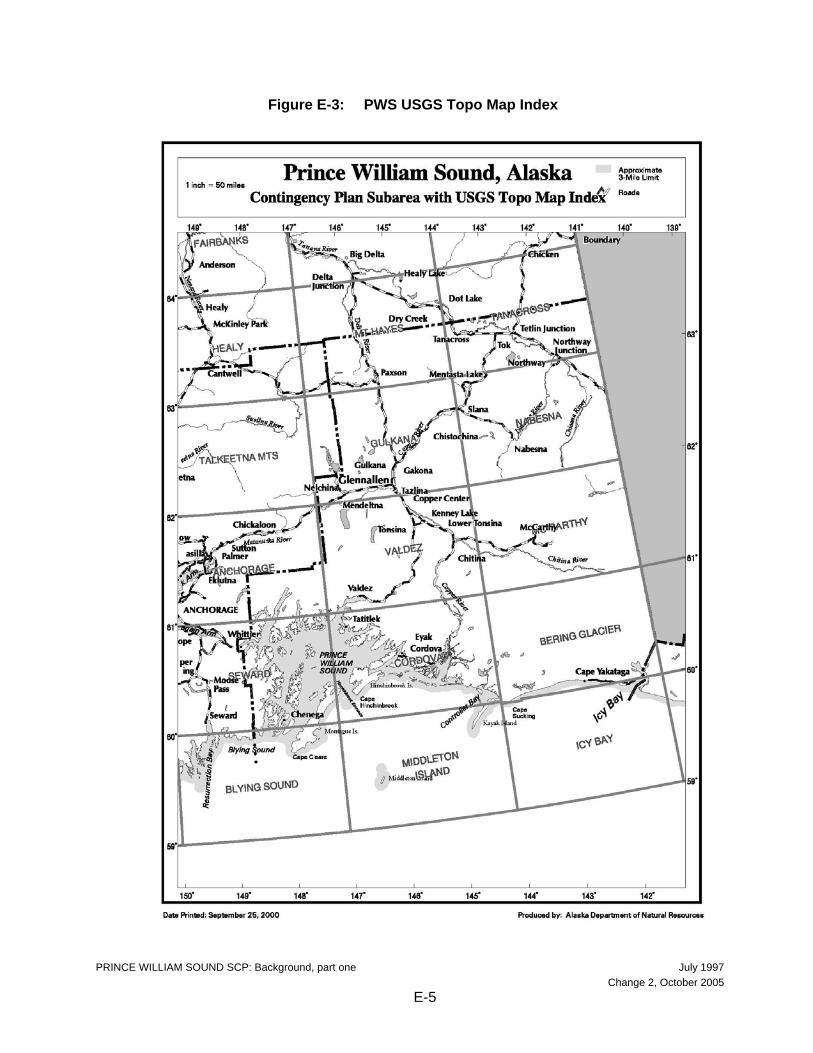
Figure E-3: PWS USGS Topo Map Index
PRINCE WILLIAM SOUND SCP: Background, part one July 1997 Change 2, October 2005 E-5
Figure E-4: PWS Nautical Chart Map Index
PRINCE WILLIAM SOUND SCP: Background, part one July 1997 Change 2, October 2005 E-6
The NOAA charts immediately after this page are also available at the following website: http://www.asgdc.state.ak.us/maps/cplans/base/AK-Circ.pdf
PRINCE WILLIAM SOUND SCP: Background, part one July 1997 Change 2, October 2005 E-7
PRINCE WILLIAM SOUND SCP: Background, part one July 1997 Change 2, October 2005 E-8
Figure E-6: Kayak Island - Eddies
PRINCE WILLIAM SOUND SCP: Background, part one July 1997 Change 2, October 2005 E-9
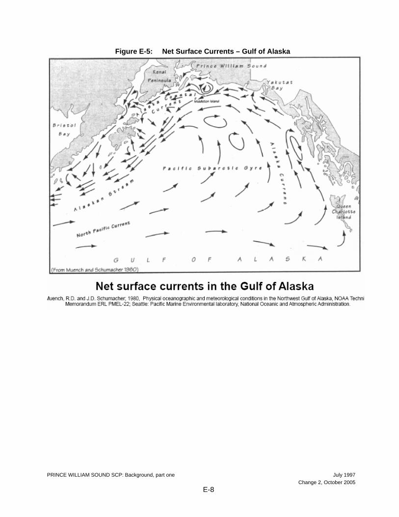
Figure E-7: Alaska Current Patterns
PRINCE WILLIAM SOUND SCP: Background, part one July 1997 Change 2, October 2005 E-10
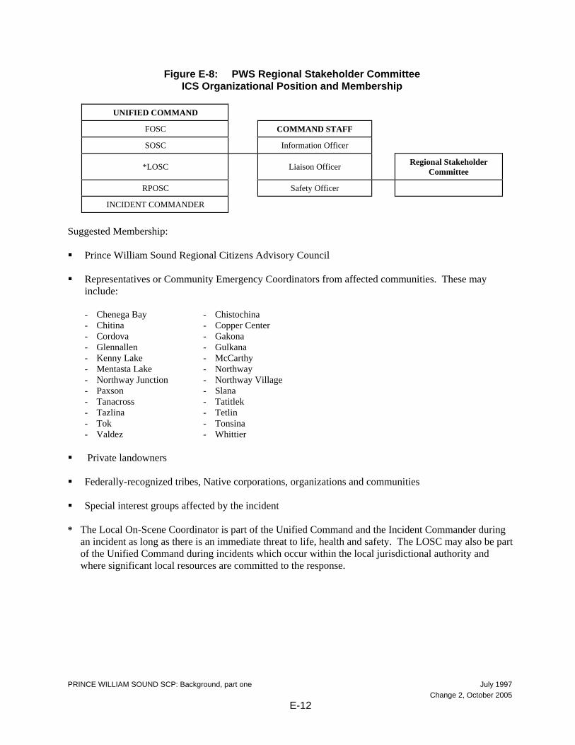
C. AREA OF RESPONSIBILITY The Prince William Sound Subarea is that area described earlier in part B. The Prince William Sound Captain of the Port (COTP) Zone for the U.S. Coast Guard is included in this subarea. The PWS COTP Zone comprises the area within the boundary which starts at Cape Puget at 148E 26' W. longitude, 59E 56.06' N. latitude, and proceeds northerly to 61E 30' N. latitude; thence easterly to the International Boundary between the United States and Canada; thence southerly along the International Boundary to 60E 18.7' N. latitude; thence southwesterly to the sea at 60E 01.3' N. latitude 142E W. longitude; thence southerly along 142E W. longitude to the outermost boundary of the EEZ; thence along the outermost boundary of the EEZ to 148E 26' W. longitude to the place of origin at Cape Puget at 59E 56.06' N. latitude. The Prince William Sound Subarea is divided into Coastal and Inland Zones to determine federal agency responsibility. In accordance with current Memoranda of Understanding, the Coast Guard is the predesignated FOSC for the Coastal Zone which encompasses all navigable waters seaward of the mean high tide line and an area of shoreline 1,000 yards inland of the coastline. The Environmental Protection Agency is the predesignated FOSC for the Inland Zone which encompasses all lands, rivers, streams, and drainages inward of the 1000-yard wide band which parallels the Alaskan coastline. The State of Alaska places jurisdiction of spill response for the Prince William Sound Subarea under the Central Alaska Response Team (CART) of the Department of Environmental Conservation. The SOSC for the CART is the predesignated SOSC for the entire Prince William Sound Subarea. D. REGIONAL STAKEHOLDER COMMITTEE A Regional Stakeholder Committee (RSC) will normally be activated for significant incidents that involve resources under the jurisdiction of several agencies. The RSC was previously referred to as the Multi-Agency Coordination Committee (MAC). Unlike the MAC defined in the ICS of the National Interagency Incident Management System, the RSC for a spill response does not play a direct role in setting incident priorities or allocating resources. The RSC can advise the Unified Command (under the guidance of the Community Liaison Officer) and provide comments and recommendations on incident priorities, objectives and action plans. Figure 3 provides the general location of the regional RSC in relation to the Unified Command organizational structure. Additionally, the suggested/potential membership of the RSC is provided in Figure 3. Membership on the RSC is dependent upon the location of the incident and the interests or jurisdiction of the affected communities, landowners, and special interest groups. During incidents where there is no FOSC, federal agencies with jurisdictional responsibilities for resources at risk could participate as a member of the RSC, thus retaining their input on containment, oversight, and cleanup. As indicated above, the RSC is not directly involved in tactical operations, though some of its members may be. The RSC’s role is to convey to the Unified Command information relating to the authority, concerns and expertise of its members. RSC members recommend to the Unified Command overall objectives and priorities and review the Incident Action Plans. RSC activities will be coordinated by the Community Liaison Officer. RSC discussions will be documented and recommendations and dissenting opinions occurring outside of RSC meeting with the Unified Command will be communicated to the Unified Command through the Liaison Officer. The RSC will be chaired initially by the Community Liaison Officer. After convening, the RSC will then elect its own chair.
PRINCE WILLIAM SOUND SCP: Background, part one July 1997 Change 2, October 2005 E-11
Figure E-8: PWS Regional Stakeholder Committee ICS Organizational Position and Membership
Suggested Membership: Prince William Sound Regional Citizens Advisory Council
Representatives or Community Emergency Coordinators from affected communities. These may
include:
- Chenega Bay - Chistochina - Chitina - Copper Center - Cordova - Gakona - Glennallen - Gulkana - Kenny Lake - McCarthy - Mentasta Lake - Northway - Northway Junction - Northway Village - Paxson - Slana - Tanacross - Tatitlek - Tazlina - Tetlin - Tok - Tonsina - Valdez - Whittier
Private landowners
Federally-recognized tribes, Native corporations, organizations and communities
Special interest groups affected by the incident
* The Local On-Scene Coordinator is part of the Unified Command and the Incident Commander during
an incident as long as there is an immediate threat to life, health and safety. The LOSC may also be part of the Unified Command during incidents which occur within the local jurisdictional authority and where significant local resources are committed to the response.
PRINCE WILLIAM SOUND SCP: Background, part one July 1997 Change 2, October 2005 E-12
E. REGIONAL CITIZENS ADVISORY COUNCIL The Prince William Sound Regional Citizens Advisory Council (RCAC) is a local citizens group with an Oil Pollution Act of 1990-mandated role in PWS spill response activities. In this role, the RCAC participates with the incident management team at the emergency operations center and monitors on-water activities during a spill. The RCAC has four primary tasks to perform during a spill: observe, verify, inform, and advise. By observing and verifying emergency spill response and cleanup efforts, the RCAC is able to properly inform local residents, communities and concerned groups. The RCAC also provides information on local knowledge and concerns to incident commanders that can prove valuable to operational decisions. The RCAC is a resource for the Unified Command and participates in the Regional Stakeholder Committee when it is established and functioning for a spill response. Specific responsibilities of the RCAC include: Providing a voice for local communities and citizens in the policies and decisions that affect them.
Advising the oil industry and the public on oil spill prevention and response, and ways to mitigate the
environmental impact of terminal, offshore oil facilities, and tanker operations. Monitoring terminal, tanker, and offshore oil facilities operations and implementation of spill
prevention and response plans. Increasing public awareness of private oil industry's current capabilities in spill prevention and
response, and the environmental impacts of oil transportation. Fostering long term partnership between industry, government and local communities.
Conducting independent research.
Participating in, monitoring, and critiquing actual spill responses, spill drills, deployment exercises, and
spill simulations conducted by industry. The RCACs also assist industry and regulatory agencies in drill planning and post-drill evaluations.
Participating in the Regional Stakeholder Committee.
Preparing and maintaining an RCAC Emergency Response Plan outlining the Council's role and
operating procedures in the event of a major spill. F. SUBAREA COMMITTEE The primary role of the Subarea Committee is to act as a preparedness and planning body for the subarea. The Subarea Committee consists of the predesignated FOSCs and SOSC for the subarea and, depending upon the event or the issues to be addressed, local government representatives. Each member is empowered by their own agency to make decisions on behalf of the agency and to commit the agency to carrying out roles and responsibilities as described in this plan and the Unified Plan. The predesignated Federal On-Scene Coordinators for the area (EPA & USCG) will serve as chairpersons of the committee.
PRINCE WILLIAM SOUND SCP: Background, part one July 1997 Change 2, October 2005 E-13
The Subarea Committee is encouraged to solicit advice, guidance or expertise from all appropriate sources and establish work groups as necessary to accomplish the preparedness and planning tasks. Work group participants may include facility owners/operators, shipping company representatives, cleanup contractors, emergency response officials, marine pilot associations, academia, environmental groups, consultants, response organizations and representatives from regional citizens’ advisory councils. Subarea Committee Members The Prince William Sound Subarea Committee is comprised of the following:
U.S. Coast Guard, COTP Prince William Sound U.S. Environmental Protection Agency Alaska Department of Environmental Conservation and local government where applicable
Subarea Work Groups The Prince William Sound Subarea Committee relies on the input from the three work groups listed below. The Subarea Committee welcomes interested participants to serve on work groups in accordance with each individual’s area of expertise and the particular needs of the work groups. The Sensitive Areas Work Group is chaired by a representative from the Department of Interior. The
primary purpose of the Sensitive Areas Work Group is to develop and maintain the Sensitive Areas section of the plan.
The Logistics Work Group is chaired by a representative from the ADEC. The primary purpose of the
Logistics Work Group is to develop and maintain the Resources Section of the plan. The Operations Work Group is chaired by a representative from the U.S. Coast Guard. The primary
purpose of the Operations Work Group is to develop and maintain the Response Section, the Hazmat Section, and the Scenarios Section of the plan.
Membership on the work groups can vary and fluctuate but the list below provides some of the regular participants: PWS Regional Citizens Advisory Council
City of Cordova
City of Valdez
Village of Tatitlek
Village of Chenega
representatives from LEPCs and other local governments
Alyeska Pipeline Service Company
Alyeska Ship Escort Response Vessel System (SERVS)
PRINCE WILLIAM SOUND SCP: Background, part one July 1997 Change 2, October 2005 E-14
British Petroleum Oil Shipping Company
ConocoPhillips Alaska Inc.
representatives from other industry and commercial concerns
Alaska Department of Environmental Conservation
Alaska Department of Fish and Game
Alaska Department of Natural Resources
U.S. Coast Guard, COTP, MSO Valdez
USCG 17th District
U.S. Department of Interior, Office of Environmental Policy and Compliance
U.S. Department of Interior, Fish and Wildlife Service
U.S. Forest Service
National Oceanic and Atmospheric Administration
National Marine Fisheries Service
Each of the above work groups are also involved in reviewing and providing comments on the other sections of the plan (including the Geographic Response Strategies section.)
PRINCE WILLIAM SOUND SCP: Background, part one July 1997 Change 2, October 2005 E-15
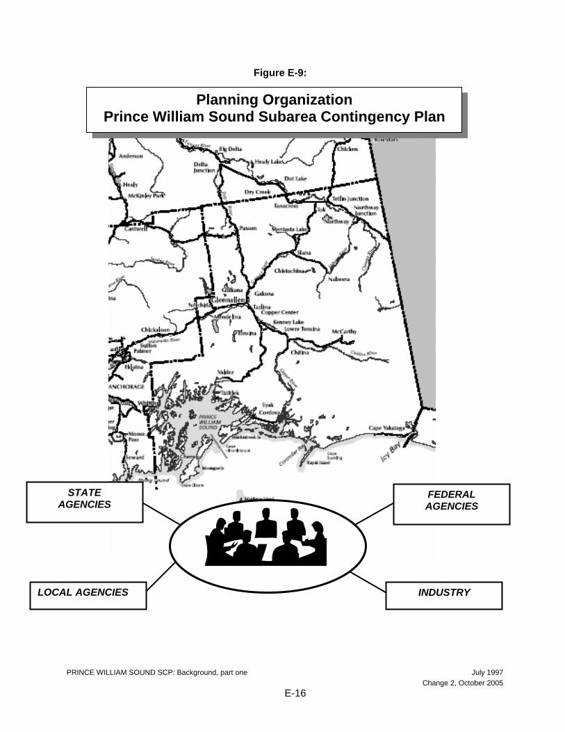
Figure E-9:
Planning Organization, Prince William Sound Subarea Contingency Plan
Planning Organization Prince William Sound Subarea Contingency Plan
LOCAL AGENCIES
STATE AGENCIES
FEDERAL AGENCIES
INDUSTRY
PRINCE WILLIAM SOUND SCP: Background, part one July 1997 Change 2, October 2005 E-16
BACKGROUND: PART TWO – RESPONSE POLICY AND STRATEGIES The strategy for responding to a specific spill or hazmat incident depends upon numerous factors. The strategy can change as the situation changes. As a general rule, the strategies listed below should be used as a guide in developing an effective response. Consider all factors that may affect the particular situation and revise/modify/expand these priorities as the situation dictates. The strategies are further delineated in the procedures contained in the Response Section. Additional information can be found in the Unified Plan. A. FEDERAL RESPONSE ACTION PRIORITIES/STRATEGIES The following priorities are general guidelines for response to a pollution incident within the COTP Prince William Sound zone. They are based on the premise that the safety of life is of paramount importance in any pollution incident, with the protection of property and the environment, although important, being secondary. Nothing in this part is meant to indicate that higher priority items must be completed before performing a lower priority task. They may be carried out simultaneously or in the most logical sequence for each individual incident. Priority One - Safety of Life - for all incidents which may occur, the safety of personnel, including
response personnel, must be given absolute priority. No personnel are to be sent into an affected area without first determining the hazards involved and that adequate precautions have been taken to protect personnel.
Priority Two - Safety of Vessel/Facility and Cargo - the facility and/or vessel and its cargo shall
become the second priority. Priority Three - Protection of the Environment by elimination of the pollution source - containment and
recovery of oil in the open water must be effected expeditiously to preclude involvement of the beaches and shorelines. Due to remote locations and restricted accessibility, it is extremely difficult to protect the majority of the coastline by diversion or exclusion methods. Therefore, securing the source and open water containment and recovery is especially critical and should normally be the first line of defense to protect the environment. Likewise, spills which occur on land or in upland water courses will be dammed, boomed, diked, etc., as feasible to prevent the spread of the pollutant downstream. NOTE: In situ burning (Unified Plan, Annex F for checklist) of a vessel and its pollutant may be an alternative considered by the OSCs; this strategy places environmental protection priorities above saving the vessel and its cargo.
Priority Four - Protection of the Environment by diversion/exclusion, dispersion, or in-situ burning. In
the event that the location of a spill or the weather conditions do not permit open water recovery, protection of the shoreline becomes paramount, especially areas of greatest sensitivity. It is not possible to protect some areas entirely or even in part. It may be necessary to sacrifice some areas in order to achieve the best overall protection of the environment. The OSC may consider in situ burning as a response option. Refer to the Unified Plan for an in situ burning checklist. The use of dispersants must be considered early in the response phase while the oil is in the open water. Subpart J of the NCP and the Unified Plan (Annex F) address in detail the responsibilities of the OSC in the use of chemicals.
Priority Five - Protection of the Environment by beach cleanup and the use of Sacrificial Areas. It may
not be possible to protect the entire shoreline from oil. In fact, it may be allowed purposely to come ashore in some areas as an alternative to damaging others. Selection of the proper shoreline cleanup technique depends on many different factors including the following:
PRINCE WILLIAM SOUND SCP: Background, part two July 1997 Change 2, October 2005 E-17
- Type of substrate - Amount of oil on the shoreline - Depth of oil in the sediment - Type of oil (tar balls, pooled oil, viscous coating, etc.) - Trafficability of equipment on the shoreline - Environmental or cultural sensitivity of the oil shoreline - Prevailing oceanographic and meteorological conditions
The best way to minimize debate over the most appropriate response is to involve all interested government and private agencies. The shoreline assessment groups shall attempt to agree on the amount and character of the oil that is on the shorelines, anticipate interactions between the stranded oil and the environment, and the geological and ecological environment of the involved shorelines. Once a consensus is met, a process is necessary to determine the proper treatment required. Shoreline cleanup options may include the use of physical and/or chemical processes. Chemical shoreline cleanup products may increase the efficiency of water-washing during the cleanup of contaminated shorelines. However, the product must be listed on the EPA National Contingency Plan Product Schedule and authorization must be obtained from the ARRT and the government on-scene coordinator at the spill. Physical shoreline cleaning methods include techniques such as: natural recovery, manual sorbent application, manual removal of oiled materials, low pressure flushing (ambient temperature), vacuum trucks, warm water washing, high pressure flushing, manual scraping, mechanical removal using heavy equipment. Bioremediation is also considered as a shoreline cleaning method. Bioremediation is the application of nutrients to the shoreline to accelerate the natural biodegradation of oil. The OSC shall request site-specific guidelines for source protection measures required during shoreline cleanup operations. B. STATE OF ALASKA RESPONSE PRIORITIES 1. Safety: Ensure the safety of persons involved, responding, or exposed to the immediate effects of
the incident. 2. Public Health: Ensure protection of public health and welfare from the direct or indirect effects of
contamination of drinking water, air, and food. 3. Environment: Ensure protection of the environment, natural and cultural resources, and biota
from the direct or indirect effects of contamination. 4. Cleanup: Ensure adequate containment, control, cleanup and disposal by the responsible party or
supplement or take over when cleanup is inadequate. 5. Restoration: Ensure assessment of contamination and damage and restoration of property, natural
resources and the environment. 6. Cost Recovery: Ensure recovery of costs and penalties to the Response Fund for response,
containment, removal, remedial actions, or damage.
PRINCE WILLIAM SOUND SCP: Background, part two July 1997 Change 2, October 2005 E-18
COOK INLET SCP: Background, part three July 1997
Change 2, October 2005 E-19
BACKGROUND: PART THREE – AREA SPILL HISTORY The following spill history was obtained from the Alaska Department of Environmental Conservation and U.S. Coast Guard records. This partial listing includes only the more significant spills or hazardous material releases. This abbreviated spill history is provided to give an overall view of the vast array of facility and transportation-related accidents that can occur. Prince William Sound supports a wide variety of marine vessel traffic including everything from the smallest pleasure craft to the crude oil supertankers calling on the Alyeska Marine Terminal in Port Valdez. The cities of Valdez, Cordova, Glennallen, Mentasta and many other small villages are not immune to oil discharges or hazardous material releases. The number of fuel transfers that take place in these towns is staggering, thus the opportunity for a spill is greatly increased. The most notable spill in Prince William Sound was the Exxon Valdez incident. This led to the passing of the Oil Pollution Act of 1990 which greatly improved oil spill response capabilities in the United States.
COOK INLET SCP: Background, part three July 1997
Change 2, October 2005 E-20
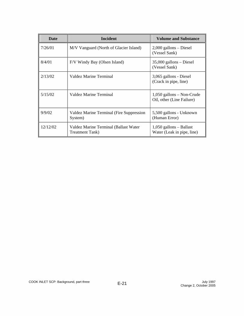
A. NAVIGABLE WATERS (SPILLS GREATER THAN OR EQUAL TO 1,000 GALLONS)
Date Incident Volume and Substance
01/03/89 T/V Thompson Pass, Berth 4, Valdez
60,000 to 75,000 gallons - North Slope Crude
01/16/89 T/V Cove Leader, Berth 3, Valdez
2,500 to 3,000 gallons - North Slope Crude
03/24/89 T/V Exxon Valdez, Bligh Reef
10,800,000 gallons - North Slope Crude
03/04/90 PWS Aquaculture, Cannery Creek Hatchery 2,200 gallons - Diesel
06/01/91 F/V Kristine, Montague Island 1,800 gallons - Diesel
02/29/92 F/V Granny Rosa, Galena Bay 1,500 gallons - Diesel
02/94 Tesoro Fuel Dock 1,000 gallons - Diesel
05/21/94 T/V Eastern Lion 8,400 gallons - North Slope Crude
11/07/95 TransAlaska Pipeline System (Pump Station 10)
5,800 pounds - Halon
1/08/95 TransAlaska Pipeline System (Pump Station 10)
5,800 pounds - Halon
COOK INLET SCP: Background, part three July 1997
Change 2, October 2005 E-23
Date Incident
04/20/96 TransAlaska Pipeline System (Check Valve 92)
34,073 gallons - North Slope Crude Oil
08/26/96 TransAlaska Pipeline System (Pump Station 10)
2,300 pounds - Halon
10/09/96 Gakona Junction Village Roadhouse
7,000 gallons - Diesel
01/26/97 Petro Star Refinery (Valdez)
4,200 gallons - Crude Oil
02/17/99 Valdez Petroleum Terminal Tank #18
8,400 gallons – Diesel
8/16/99 TransAlaska Pipeline System (Pump Station 10)
4,400 pounds – Halon
10/19/99 Cordova - Eyak Lake - Waste Oil Release
1,000 gallons – Waste Oil (containment overflow)
7/28/00 Richardson Highway South – Mile 19 Gravel Pit
2,000 gallons – Asphalt (Cause unknown)
8/3/01 Cordova - Orca Power Generation Plant
1,500 gallons – Diesel (Tank Overfill)
12/31/01 Chitina Electric Power Plant
1,000 gallons – Diesel (Valve failure)
COOK INLET SCP: Background, part three July 1997
Change 2, October 2005 E-24
C. HAZMAT RELEASE HISTORY Listed below is a brief synopsis of significant releases of hazardous substances in the region. This information was collected from the ADEC spill database; a complete list is available through ADEC.
D. CLOSER LOOK AT SOME NOTEWORTHY SPILLS January 3, 1989 T/V Thompson Pass Location: Berth 4, Valdez Marine Terminal Product: 60,000 to 75,000 gallons of ANS crude oil An oily sheen was initially observed in while the vessel was offloading at a southern port. During on-loading operations at the Valdez Marine Terminal, crude oil was released through a crack in the hull. March 24, 1989 T/V Exxon Valdez Location: Near the mouth of the Valdez Arm, off Bligh I. in Prince William Sound Product: Nearly 11 million gallons of ANS crude oil Just after midnight, the supertanker Exxon Valdez, containing more than 53 million gallons of oil, ran aground on the charted rocks of Bligh Reef after exiting the prescribed tanker navigation lanes in an effort to avoid icebergs from nearby Columbia Glacier. The impact ruptured eight of the eleven cargo tanks. Oil spewed out of the tanker in such quantities that, for a while, the slick stood at over two feet thick in places. Within 36 hours after the grounding, and with the weather holding calm, air reconnaissance reported the oil slick to be 10 miles long and 3 to 7 mile wide. Despite calm weather for the first three days, spill response efforts were stymied by confusion, lack of equipment, and misunderstandings over proper response and control. A major storm, boasting winds up to 73mph, blasted through the Sound on Sunday night, March 26, spreading oil in all directions and coating the first of many miles of shoreline. Eventually, over 1200 miles of coastline would be impacted by oil, including the outer Kenai coast and islands, reaching the mouth of Kachemak Bay, and out to Kodiak Island and the Alaskan Peninsula. Exxon mounted a major shoreline cleanup effort during the summer of 1989, and similar but much reduced cleanup activities during the summers of 1990 and 1991. Recent studies report various parts of the coastal ecosystem still exhibiting negative effects from the oil spill. April 20, 1996 TAPS Check Valve 92 Location: Alyeska Pipeline MP 593.7, at check valve 92, about 7 miles south of Pump Station 10. Product: 34,073 gallons of ANS Crude Oil The leak was caused by a leak in the by-pass valve threadlet. Alyeska discovered crude oil in two metal culvert access pipes about 60 feet north of check valve 92. About 16 inches of crude (about 100 gallons) was pumped from the pipes. Oil seeped into the pipes at a rate of about 6 - 8 gallons per hour. Alyeska reduced the pipeline throughput from 1.5 million barrels per day to 700,000 barrels per day, and pumped crude oil from the storage tanks at PS 10 to make storage available in case the line needs to be evacuated for repairs. An Incident Management Team was activated and based at Pump Station 10. Four task forces were organized to address the spill. Task force 1 excavated in the area around check valve 92. Task force 2 excavated near the metal culvert pipes and located the leading edge of the spill. Task force 3 established a contaminated soil stockpile and Task Force 4 provided decon. DEC and Joint Pipeline Office staff responded and monitored initial and follow-on response actions and reviewed cleanup plans. August 4, 2001 F/V Windy Bay Location: Olsen Rock, east of Olsen Island, northern Prince William Sound Product: 35,000 gallons of diesel The F/V Windy Bay ran aground at 10:45 am and sank at 1:56 pm in about 1000 feet of water. The vessel contained 35,000 gallons of diesel fuel at the time of sinking. The vessel also carried 100 gallons lube oil and 300-500 gallons hydraulic fluid. An on scene responder estimated the daily release rate at about 60 gallons fuel a day. Because of the great depth for the boom anchoring systems, oversized
COOK INLET SCP: Background, part three July 1997
Change 2, October 2005 E-26
anchors and buoys were mobilized. The Coast Guard, Dec, Alaska Chadux and SERVS responded to the incident. Containment boom was deployed to protect identified sensitive areas. The open-water recovery operations applied two Current Buster systems. Wildlife in the area included numerous seabirds, bald eagles, sea otters, sea lions, and humpback whales. Seven dead oiled birds were recovered (6 Marbled Murrelets and 1 Scoter). USF&WS otter specialists demobilized after observing that sixty otters in the area exhibited normal behavior and did not appear to have suffered any impacts. One SCAT team assessed shorelines for oil-impacts. Approximately 5.7 miles of shoreline were surveyed. Beach cleanup crews worked on Little Fairmont and Little Olsen Island. Natural flushing supplemented with low-pressure water spray was used on the oiled shoreline at these locations.
COOK INLET SCP: Background, part three July 1997
Change 2, October 2005 E-27
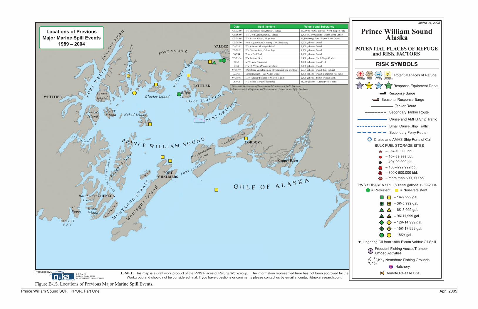
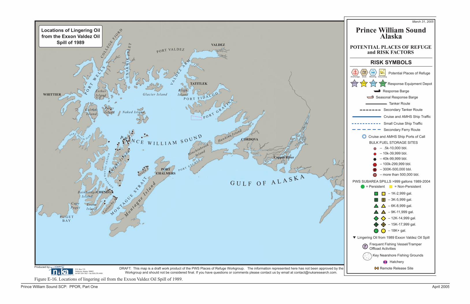
E. PWS Risk Assessment Maps: The maps on the following pages were prepared as part of the risk assessment process during the development of the potential places of refuge section (Section H) of this plan.
Prince William Sound SCP: PPOR, Part One April 2005
DRAFT: This map is a draft work product of the PWS Places of Refuge Workgroup. The information represented here has not been approved by the Workgroup and should not be considered final. If you have questions or comments please contact us by email at [email protected].
Produced by:P.O. Box 175Seldovia, Alaska 99663tel 907.234.7821 • fax 509.278.4406
Prince William Sound SCP: PPOR, Part One April 2005
Figure E-11. Primary Traffi c Routes for State Ferries and Cruise Ships.
Port # of Cruise Ship Visits������������� ���
������� �
������ ���
������
��������
��������
�������
��
# of Ferry Vessel Visits
���
���
��
��
��
���������� ��� ���
Primary Traffic Routes for State Ferries & Cruise Ships
Reference – Alaska Department of Transportation, Alaska Marine Highway 2003-2004 Schedule, Database online http://www1.dot.state.ak.us/amhs/schedres/scheds/index.html
Reference – Northwest Cruiseship Association Database online, http://www.alaskacruises.org/ports/scheduleintro.cfm, 2003 Port Schedule.xls
Reference – Southwest Alaska Pilots Association
��������������������������
������������������������������������������
March 31, 2005
CO
LL
EG
E F
J OR
D
���
��
�� �
� ��
��
�
��
��
� ��
��
�
WHITTIEREsther Is land
Perry Is land
Culross Is land Naked Is land
Glacier Is land
� � � � � � � � � � � � � � � � � � � � � �
VA
LD
EZ
AR
M
P O RT VA L D E ZVALDEZ
TATITLEK
Bligh Is land
� � � � � � � � � � � �
G U L F O F A L A S K A� � � � � � � � �
� �
Hinchinbrook
Is land
���������� ����
� � ��
��
��
��
� ��
��
� �
CHENEGA
PORTCHALMERS
P U G E TB AY
�� � � �
� � � � �� � �
� �
�� � �
� � �� �
� �� �
Latouch
e I .
Green I .
Cape Puget
Evans Is land
Bainbridge Is land
CORDOVA
DRAFT: This map is a draft work product of the PWS Places of Refuge Workgroup. The information represented here has not been approved by the Workgroup and should not be considered final. If you have questions or comments please contact us by email at [email protected].
Produced by:P.O. Box 175Seldovia, Alaska 99663tel 907.234.7821 • fax 509.278.4406
Prince William Sound SCP: PPOR, Part One April 2005
Figure E-12. Primary Traffi c Routes for Crude Oil Tankers.
Primary Traffic Routesfor Crude Oil Tankers
��������������������������
������������������������������������������
March 31, 2005
CO
LL
EG
E F
J OR
D
���
��
�� �
� ��
��
�
��
��
� ��
��
�
WHITTIEREsther Is land
Perry Is land
Culross Is land Naked Is land
Glacier Is land
� � � � � � � � � � � � � � � � � � � � � �
VA
LD
EZ
AR
M
P O RT VA L D E ZVALDEZ
TATITLEK
Bligh Is land
� � � � � � � � � � � �
G U L F O F A L A S K A� � � � � � � � �
� �
Hinchinbrook
Is land
���������� ����
� � ��
��
��
��
� ��
��
� �
CHENEGA
PORTCHALMERS
P U G E TB AY
�� � � �
� � � � �� � �
� �
�� � �
� � �� �
� �� �
Latouch
e I .
Green I .
Cape Puget
Evans Is land
Bainbridge Is land
CORDOVA
DRAFT: This map is a draft work product of the PWS Places of Refuge Workgroup. The information represented here has not been approved by the Workgroup and should not be considered final. If you have questions or comments please contact us by email at [email protected].
Produced by:P.O. Box 175Seldovia, Alaska 99663tel 907.234.7821 • fax 509.278.4406
Prince William Sound SCP: PPOR, Part One April 2005
Figure E-13. Locations of Frequent Fishing Vessel/Tramper Offl oad Activities.
T T
T
T
T
T
T
T
T
Locations of Frequent Fishing Vessel/Tramper
Offload ActivitiesResources: Southwest Alaska Pilots Assn.
��������������������������
������������������������������������������
March 31, 2005
CO
LL
EG
E F
J OR
D
���
��
�� �
� ��
��
�
��
��
� ��
��
�
WHITTIEREsther Is land
Perry Is land
Culross Is land Naked Is land
Glacier Is land
� � � � � � � � � � � � � � � � � � � � � �
VA
LD
EZ
AR
M
P O RT VA L D E ZVALDEZ
TATITLEK
Bligh Is land
� � � � � � � � � � � �
G U L F O F A L A S K A� � � � � � � � �
� �
Hinchinbrook
Is land
���������� ����
� � ��
��
��
��
� ��
��
� �
CHENEGA
PORTCHALMERS
P U G E TB AY
�� � � �
� � � � �� � �
� �
�� � �
� � �� �
� �� �
Latouch
e I .
Green I .
Cape Puget
Evans Is land
Bainbridge Is land
CORDOVA
DRAFT: This map is a draft work product of the PWS Places of Refuge Workgroup. The information represented here has not been approved by the Workgroup and should not be considered final. If you have questions or comments please contact us by email at [email protected].
Produced by:P.O. Box 175Seldovia, Alaska 99663tel 907.234.7821 • fax 509.278.4406
Prince William Sound SCP: PPOR, Part One April 2005
Figure E-14. Locations of Key Nearshore Fishing Grounds, Hatcheries, and Remote Releast Sites.
Locations of Key Nearshore Fishing Grounds,
Hatcheries, and Remote Release Sites
Resources: Mark Fink/ADF&G
Closed to commercial salmon fishing.
��������������������������
������������������������������������������
March 31, 2005
CO
LL
EG
E F
J OR
D
���
��
�� �
� ��
��
�
��
��
� ��
��
�
WHITTIEREsther Is land
Perry Is land
Culross Is land Naked Is land
Glacier Is land
� � � � � � � � � � � � � � � � � � � � � �
VA
LD
EZ
AR
M
P O RT VA L D E ZVALDEZ
TATITLEK
Bligh Is land
� � � � � � � � � � � �
G U L F O F A L A S K A� � � � � � � � �
� �
Hinchinbrook
Is land
���������� ����
� � ��
��
��
��
� ��
��
� �
CHENEGA
PORTCHALMERS
P U G E TB AY
�� � � �
� � � � �� � �
� �
�� � �
� � �� �
� �� �
Latouch
e I .
Green I .
Cape Puget
Evans Is land
Bainbridge Is land
CORDOVA
DRAFT: This map is a draft work product of the PWS Places of Refuge Workgroup. The information represented here has not been approved by the Workgroup and should not be considered final. If you have questions or comments please contact us by email at [email protected].
Produced by:P.O. Box 175Seldovia, Alaska 99663tel 907.234.7821 • fax 509.278.4406
Prince William Sound SCP: PPOR, Part One April 2005
Locations of Lingering Oil from the Exxon Valdez Oil
Spill of 1989
��������������������������
������������������������������������������
March 31, 2005
CO
LL
EG
E F
J OR
D
���
��
�� �
� ��
��
�
��
��
� ��
��
�
WHITTIEREsther Is land
Perry Is land
Culross Is land Naked Is land
Glacier Is land
� � � � � � � � � � � � � � � � � � � � � �
VA
LD
EZ
AR
M
P O RT VA L D E ZVALDEZ
TATITLEK
Bligh Is land
� � � � � � � � � � � �
G U L F O F A L A S K A� � � � � � � � �
� �
Hinchinbrook
Is land
���������� ����
� � ��
��
��
��
� ��
��
� �
CHENEGA
PORTCHALMERS
P U G E TB AY
�� � � �
� � � � �� � �
� �
�� � �
� � �� �
� �� �
Latouch
e I .
Green I .
Cape Puget
Evans Is land
Bainbridge Is land
CORDOVA
DRAFT: This map is a draft work product of the PWS Places of Refuge Workgroup. The information represented here has not been approved by the Workgroup and should not be considered final. If you have questions or comments please contact us by email at [email protected].
Produced by:P.O. Box 175Seldovia, Alaska 99663tel 907.234.7821 • fax 509.278.4406
OrganizationLocations of Spill Response Hubs &Equipment Depots
��������������������������
������������������������������������������
March 31, 2005
CO
LL
EG
E F
J OR
D
���
��
�� �
� ��
��
�
��
��
� ��
��
�
WHITTIEREsther Is land
Perry Is land
Culross Is land Naked Is land
Glacier Is land
� � � � � � � � � � � � � � � � � � � � � �
VA
LD
EZ
AR
M
P O RT VA L D E ZVALDEZ
TATITLEK
Bligh Is land
� � � � � � � � � � � �
G U L F O F A L A S K A� � � � � � � � �
� �
Hinchinbrook
Is land
���������� ����
� � ��
��
��
��
� ��
��
� �
CHENEGA
PORTCHALMERS
P U G E TB AY
�� � � �
� � � � �� � �
� �
�� � �
� � �� �
� �� �
Latouch
e I .
Green I .
Cape Puget
Evans Is land
Bainbridge Is land
CORDOVA
DRAFT: This map is a draft work product of the PWS Places of Refuge Workgroup. The information represented here has not been approved by the Workgroup and should not be considered final. If you have questions or comments please contact us by email at [email protected].
Produced by:P.O. Box 175Seldovia, Alaska 99663tel 907.234.7821 • fax 509.278.4406
Prince William Sound SCP: PPOR, Part One April 2005
Figure E-18. Potential Places of Refuge and all Risk Factors Combined.
T T
T
T
T
T
T
T
T
6
A-03
A-13
A-14
A-15
A-16
A-17
A-20
A-19
A-21 A-22
A-28
A-29
A-31
A-32
A-33
A-35
A-36
A-57
A-56
A-58
A-37
A-41A-40
A-42
A-46A-48
A-47
A-49
A-50A-51
A-53
A-54
A-38
A-23
A-02 A-01
D-04 D-06
D-34
D-07
D-08D-11
D-10
D-09
D-18
D-25
M-12
M-30
M-39
D-43D-45
D-44
D-05
G-58
G-55
G-57
G-59
G-60
G-61
G-62
G-65
G-66
G-66
G-63
G-56
A-24 D-27
D-26
��������������������������
������������������������������������������
March 31, 2005
CO
LL
EG
E F
J OR
D
���
��
�� �
� ��
��
�
��
��
� ��
��
�
WHITTIEREsther Is land
Perry Is land
Culross Is land Naked Is land
Glacier Is land
� � � � � � � � � � � � � � � � � � � � � �
VA
LD
EZ
AR
M
P O RT VA L D E ZVALDEZ
TATITLEK
Bligh Is land
� � � � � � � � � � � �
G U L F O F A L A S K A� � � � � � � � �
� �
Hinchinbrook
Is land
���������� ����
� � ��
��
��
��
� ��
��
� �
CHENEGA
PORTCHALMERS
P U G E TB AY
�� � � �
� � � � �� � �
� �
�� � �
� � �� �
� �� �
Latouch
e I .
Green I .
Cape Puget
Evans Is land
Bainbridge Is land
CORDOVA
DRAFT: This map is a draft work product of the PWS Places of Refuge Workgroup. The information represented here has not been approved by the Workgroup and should not be considered final. If you have questions or comments please contact us by email at [email protected].
Produced by:P.O. Box 175Seldovia, Alaska 99663tel 907.234.7821 • fax 509.278.4406
BACKGROUND: PART FOUR – ABBREVIATIONS AND ACRONYMS ACP Area Contingency Plan ACS Alaska Clean Seas (North Slope industry cooperative) ADEC Alaska Department of Environmental Conservation ADF&G Alaska Department of Fish and Game, also as ADFG ADNR Alaska Department of Natural Resources ADOT&PF Alaska Department of Transportation and Public Facilities; also as ADOTPF AFB Air Force Base ANS or ANSC Alaska North Slope crude oil APSC Alyeska Pipeline Service Company ARRT Alaska Regional Response Team; also as AKRRT BBLS Barrels BLM US Bureau of Land Management BOA Basic Ordering Agreement (for federal contractors) CART Central Alaska Response Team (ADEC) CCGD 17 Commander, Coast Guard District 17 CISPRI Cook Inlet Spill Prevention and Response Inc. (industry cooperative) COTP Captain of the Port (USCG) CTAG Cultural Technical Advisory Group DOA US Department of Agriculture DOC US Department of Commerce DOD US Department of Defense DOI US Department of the Interior DRAT District Response Advisory Team (USCG) DRG District Response Group (USCG) EPA Environmental Protection Agency; also as USEPA ESI (Alaskan) Environmental Sensitivity Index F/V Fishing Vessel FAA Federal Aviation Administration FOSC Federal On-Scene Coordinator GIS Geographic Information System GRS Geographic Response Strategies GSA General Services Administration HAZMAT Hazardous Materials; also as hazmat HAZWOPER Hazardous Waste Operations and Emergency Response ICS Incident Command System IDLH Immediate Danger to Life and Health INMARSAT International Maritime Satellite Organization JPO Joint Pipeline Office (gov’t agencies involved with managing/regulating TAPS) LEPC Local Emergency Planning Committee LEPD Local Emergency Planning District LNG Liquefied Natural Gas M/V Motor Vessel MLT Municipal Lands Trustee Program MOA Memoranda of Agreement, or Municipality of Anchorage MOU Memoranda of Understanding MSO Marine Safety Office (USCG) MSRC Marine Spill Response Corp. (national industry cooperative) M/V Motor Vessel
PRINCE WILLIAM SOUND SCP: Background, part four July 1997 Change 2, October 2005 E-37
NART Northern Alaska Response Team (ADEC) NCP National Contingency Plan NIMS National Incident Management System NIST National Institute of Standards and Technology NMFS National Marine Fisheries Service NOAA National Oceanic and Atmospheric Administration NOTAMS Notice to All Mariners; also, Notice to Airmen NPDES National Pollution Discharge Elimination System NPFC National Pollution Fund Center NRC National Response Center NRP National Response Plan NRT National Response Team NRDA (Federal/State) Natural Resource Damage Assessment NSF National Strike Force NSFCC National Strike Force Coordinating Center NWR NOAA Weather Radio OHMSETT Oil and Hazardous Material Simulated Environment Test Tank OPA 90 Oil Pollution Act of 1990 OPCEN Operations Center OSC On-Scene Coordinator OSRO Oil Spill Response Office PIAT Public Information Assist Team PIO Public Information Officer POLREP Pollution Report (USCG) PPOR Potential Places of Refuge PWS Prince William Sound RCAC Regional Citizens Advisory Council RCRA Resource Conservation and Recovery Act of 1978 RP Responsible Party RRT Regional Response Team RSC Regional Stakeholder Committee RV Recreational Vehicle SART Southeast Alaska Response Team (ADEC) SCBA Self-Contained Breathing Apparatus SCP Subarea Contingency Plan SERVS Ship Escort Response Vessel Service (for Alyeska terminal in Valdez) SHPO State Historic Preservation Officer (ADNR) SITREP Situation Report (ADEC) SONS Spill of National Significance SOSC State-On Scene Coordinator SSC Scientific Support Coordinator (NOAA) SUPSALV U.S. Navy Supervisor of Salvage, also as NAVSUPSALV TAPS Trans Alaska Pipeline System T/V Tank Vessel USCG United States Coast Guard VIRS Visual Information Response System VMT Valdez Marine Terminal (APSC) VTS Vessel Traffic Separation System/Scheme
PRINCE WILLIAM SOUND SCP: Background, part four July 1997 Change 2, October 2005 E-38


![Sizing of a spar-type floating support structure for DeepWindFigure 2.2.1 The floating offshore windmill, from Statoil web site [3] SIZING OF A SPAR -TYPE FLOATING SUPPORT STRUCTURE](https://static.documents.pub/doc/80x56/5e892fa55dc2e623ca1d2c43/sizing-of-a-spar-type-floating-support-structure-for-deepwind-figure-221-the-floating.jpg)


