l 42I14SW0002 2 16433 CARROLL Basic Gypsum Resource Calculation and Geotechnical Report for Moose River Crossing Property Carrol and Canfield Townships Porcupine Mining Division Ontario 010 O "A" Submitted To: James Bay Lowlands Development Group January 12, 1995 Kevin Cool RECEIVED .v ^F.R 2 O 1998 MINING LANDS BRANCH
Transcript
l42I14SW0002 2 16433 CARROLL
Basic Gypsum Resource Calculation and Geotechnical Report for Moose River Crossing Property
Carrol and Canfield TownshipsPorcupine Mining Division
Ontario
010
O "A"
Submitted To:James Bay Lowlands Development Group January 12, 1995
Kevin Cool
RECEIVED
.v ^F.R 2 O 1998
MINING LANDS BRANCH
Table of Contents42I14SW0002 2 16433 CARROLL
!01OC
Introduction
Property
Location and Access
Topography and Vegetation
Exploration History
Regional Geology
1995 Work
General Notes on Establishing Camp and the Topographic Survey
Recommendations and Conclusion
References
Appendix I: Moose River Gypsum Exploration Expenses
.1
.2
.2
.2
.4
.5
.7
.10
.10
.11
.12
List of Illustrations:
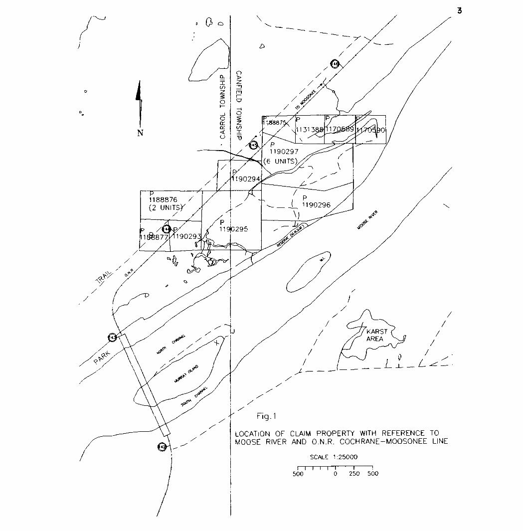
Fig l. Location of Qaim Property with Reference to Moose River and O.N.R. Cochrane-Moosonee Line
In 1994 two diamond drill holes were drilled on the Moose River Crossing Gypsum property. The conclusions of this work, based mainly on the thicknesses intercepted supported by geochemical analysis, were as follows:
The Moose River Crossing property contains a substantial, near surface deposit of high purity gypsum".
These two holes however, are not the only evidence of this vast deposit.
In 1993, our development group utilized a CAT EL200 excavator to dig test pits on the Moose River property. Four test pits up to 220m apart and 850m inland from the river outcrops, exposed the massive high purity gypsum deposit.
In 1955, a geological survey, reported by R.E. Parkes in assessment file T-634, found white and brown gypsum up to 15 ft. thick and up to 1600 ft. inland from the Moose River outcrops.
In 1925 Geo. E. Cole quotes an earlier description by J. Mackintosh Bell as follows:
"There are two beds, the upper extending along one side of the river for 2 1/2 miles and along the other side for 2 3/4 miles."
These outcrops provide an excellent cross section of the gypsum where the Moose River has cut through the deposit. The 10 metre high outcrops of massive gypsum found here further demonstrate the thicknesses that are found 850m inland. These outcrops undoubtedly provide information naturally on a large scale that cannot be outdone by the most intensive drill program. The relatively low number of inland drill holes and test pit exposures are made more relevant thanks to the presence of these outcrops.
Armed with test pit, drill hole, and some topographic data, we felt that we were close to having an estimate of available gypsum resource. Obtaining more topographic information and tying existing pit, drill hole, and topographic data into a common survey, as well as tying the river outcrops into this system has enabled us to finally calculate basic gypsum resource quantities as well as approximate overburden quantities. The survey also met our desire to be sensitive to local concerns by carrying out assessment work with a minimum of additional disturbance to the area. This report outlines the above survey work and includes the basic gypsum resource estimate that the survey made possible.
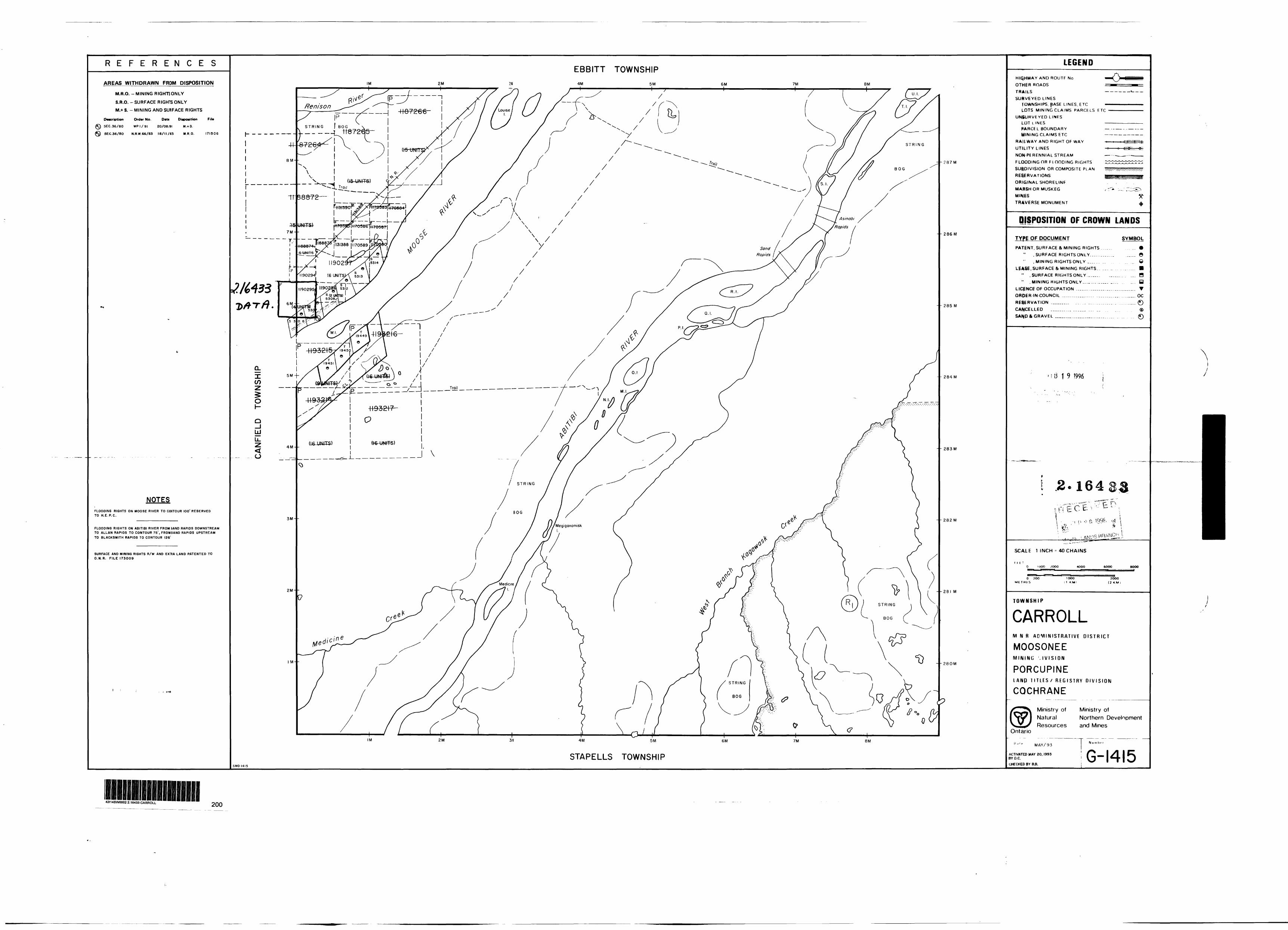
Property
The Moose River Crossing Gypsum property consists of 11 contiguous claims containing 21 units, all within Carroll and Canfield Townships, Porcupine Mining Division. The property is owned wholly by the James Bay Lowlands Gypsum Development Group. The 11 claims are divided as follows;
P 1131388 l unitP 11705 89 l unitP 1170590 l unitP 1188875 l unitP 1188877 l unitP 1188876 2 unitsP 1190293 l unitP 1190294 l unitP 1190295 4 unitsP 1190296 2 unitsP 1190297 6 units
Location and Access
The property is located in Carroll and Canfield Townships, Porcupine Mining Division, Cochrane District.
The U.T.M. for the property is approximately E480 000 N 5 631 800.
The Latitude/Longitude is approximately N50-50-20.48 and W 81-16-58.22
Figure l shows the property location with reference to the Moose River and the Ontario Northland Railway Cochrane - Moosonee Line.
Access was obtained along the O.N.R. line by snowmachine from Moosonee. A small trail was used to gain access to a cleared, semi-permanent camp site near railway milepost 144. The camp site was used for the duration of the survey work.
Topography and Vegetation
In general, the property is flat and low lying except for local topography, including old clay river levees up to 20 metres thick and 50 to over 200 metres wide. The old
\--N
CA
RR
OL
TOW
NS
HIP
dIH
SN
MO
l Q
13IJ
NV
O
m\
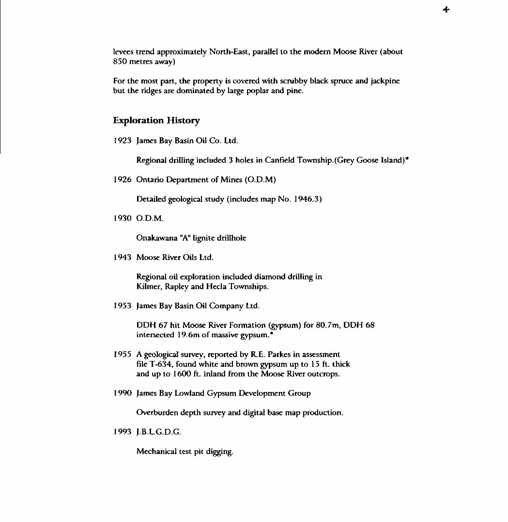
levees trend approximately North-East, parallel to the modern Moose River (about 850 metres away)
For the most part, the property is covered with scrubby black spruce and jackpine but the ridges are dominated by large poplar and pine.
Exploration History
1923 James Bay Basin Oil Co. Ltd.
Regional drilling included 3 holes in Canfield Township.(Grey Goose Island)*
1926 Ontario Department of Mines (O.D.M)
Detailed geological study (includes map No. 1946.3)
1930 O.D.M.
Onakawana "A" lignite drillhole
1943 Moose River Oils Ltd.
Regional oil exploration included diamond drilling in Kilmer, Rapley and Hecla Townships.
1953 James Bay Basin Oil Company Ltd.
DDH 67 hit Moose River Formation (gypsum) for 80.7m, DDH 68 intersected 19.6m of massive gypsum.*
1955 A geological survey, reported by R. E. Parkes in assessmentfile T-634, found white and brown gypsum up to 15 ft. thick and up to 1600 ft. inland from the Moose River outcrops.
1990 James Bay Lowland Gypsum Development Group
Overburden depth survey and digital base map production.
1993 J.B.L.G.D.G.
Mechanical test pit digging.
1994 J.B.L.G.D.G.
Diamond drilling'geology
1995 J.B.L.G.D.G.
Topographic/geological survey and basic gypsum resource calculation.
* These cores are stored, along with many other James Bay Lowland drill cores, at the Ministry of Northern Development and Mines Core Library in Timmins, On.
Regional Geology
Regional geology consists of a Precambrian basement complex covered by proterozoic-Mesozoic, basinal carbonate rocks. The Moose River Formation represents a middle Devonian sequence of bedded, basinal carbonates and evaporites, including significant gypsum. The Moose River Formation is underlain by the fossiliferous limestones of the Kwataboahegan formation, and overlain by fossiliferous dolostones and argillaceous carbonates of the Murray Island Formation. The Moose River Formation Itself Displays a distinct scarcity of fossils.
The gypsum of the Moose River Formation is best developed along the North-West trending Moose River Arch. Gypsum outcrops over an elliptical area 70km by 17km., trending North-West. Three main surface exposures include the Moose River site, and the Gypsum Mountain site. (Fig. 2)
3SOOH
N
1995 Work
A topographic survey was carried out from January 3, 1996 to January 9, 1996 at the Moose River Gypsum property. The intent of this work was both to include, in one survey, all of the locations of the 1993 and 1994 test pits and drill holes, and to tie these sites into one common elevation datum (metres above Mean Sea Level). Once completed, this survey was tied to new topographic data (also obtained during this project) and tied to the Moose River outcrop locations with newly obtained outcrop elevations.
The completed survey was utilized to further calculate the basic gypsum resource available. Overburden volumes were also obtained by using this survey data. Diagram 3 shows the Basic Gypsum Resource Plan, Contour Map, and Section Locations.
A specific area was chosen for the gypsum resource model, (see dia #3) The choice of location and area of this gypsum block was guided by the following :
The North boundary of the gypsum block is formed by a clay ridge. This old clay river levee would make it difficult to continue removeing gypsum northward because it is a thick cover. It may also be desireable to leave this ridge undisturbed for the purpose of building a spur line for railway access.
The West boundary is formed by drawing a line of shortest possible distance from test pit #9, to the gypsum outcrops along the Moose River. Test pit #9 was the Westernmost pit that produced high purity gypsum.
The East boundary is formed by drawing a line of shortest possible distance from drill hole MRC94-02, to the gypsum outcrops along the Moose River. This drill hole intercepted about 13m of gypsum, but ended there without ever leaving the gypsum.
The South boundary is formed by our property or claim boundary. It is not practical to include the ground outside of the property.
As can be seen on Fig. 3, the area of this resource block is 274, 278 sq. m. To our surprise, in every exposure the top of the gypsum deposit elevation was similar. Over the distances involved, they are basically the same. These elevations ( above sea level) are as follows:
MRC94-01 31.86m MRC 94-02 31.90m Moose River Outcrop
Exposures 32.11m
The top of the gypsum deposit within our resource block can therefore basically be called 31.75m. The elevation of the Moose River, at section line B, is approximately 26.75m. This leaves 5m of gypsum above the elevation of the Moose River over the area of the resource block. This represents l ,371,390 cubic metres of gypsum. If mining were to proceed below the Moose River water elevation, to 15 m total thickness, as found in drill hole MRC 94-01, over the total area of the resource block, this would represent 4,114,170 cubic metres of gypsum.
Using Quicksurf surface modelling software, the volume of overburden over the area of the resource block was obtained down to elevation 31.75. (top of gypsum) The contoured surface shown in diagram #3 was used for this purpose. The volume obtained was 334,993 cubic metres. This equals almost exactly 1/4 of the volume of gypsum resource as calculated down to the Moose River elevation.
Maps were created using Autocad 12 with Quicksurf surface modelling software. Results are also summarized at the end of the report.
02/83/1995 23:47 7852646718 GEN. SURVEYS S, EXPL. PAGE 81
General Notes on Establishing Camp and the Topographic Survey
Camp was established at a semi-permanent campsite cleared during October of 1994, and accessed using snowmobiles from Moosonee. As a result of the cold, the unusually laige snow accumulation, and the limited hours of daylight, travelling to the site and setting up camp required over one and a half days.
Because of a desire to minimize the ongoing impact of our assessment work, the survey was carried out without establishing cut lines on the property. This necessitated the use of snowshoe* for the January field work, as snowmobiles were incapable of navigating the bush,
A two-person crew carried elevation along lines perpendicular to the railway, heading South-East to the Moose River. The lines followed a pre-planned azimuth, but skirted natural obstacles such as sinkholes.
The work was slowed only by the obstacles inherent to winter surveying and camping: cold weather during the field work, working hours limited by short winter days, and the fact that a significant portion of available daylight hours were spent on maintaining the camp.
Recommendations and Conclusions
A bask gypsum resource calculation, and overburden volume has been obtained for an area of land within the Moose River Crossing Gypsum Property. The ratio of overburden to gypsum is about l part overburden to four parts gypsum. This ratio becomes more favourable if gypsum is extracted below the Moose River elevation. This resource block represents only a portion of the property, the remainder of which is known to be similar geologically and topographically.
Future work could include a resource calculation for the remaining area within the property. This calculation would require similar groundwork such as diamond drilling, test pit digging and topographic survey. An engineering study could also be carried out to determine the feasibility of mining below the Moose River elevation.
li
References
Cole, E., Geo. "Gypsum in Ontario"Thirty Fourth Annual Report of the Ontario Dept. of Mines Vol. XXXIV, Part II, 1925 pp. 1-34.
Gypsum in Northern Ontario; Resources and Market PotentialIndustrial Minerals Background Paper 12, 1990 M.N.D.M.
•Z.
Appendix I
Moose River Gypsum Exploration Expense
Direct Cost:
Wages: ConsultantsMapping (by GeograFix, P): 2 person crew including survey instruments
-2 days travel (Jan. 3 St Jan. 9) @ S6507day S1300-5 days field work (Jan. 4-8) @S8007day S4000
Equipment Rental-2 snowmobiles @ S50 ea/day for 5 days-tent, heater, camp equipment - flat rate from GeograFix
S500 S150
Total Direct Cost S8450
Indirect Cost:
Transportation-rail (2 people, Cochrane to Moosonee, return)-snowmobile supplies
(fuel, oil, maintenance supplies)
MobTDemob-equipment freight (rail)-transport equipment/people in Moosonee
Food - 2 people @ S307day ea for 7 days
Lodging - 2 people, 2 nights in Moosonee @S40.007night
Total Indirect Cost
S154.08
S300.00
Si 13.70 S125.00
S210.00
S80.00
S982.78
Ministry ofNorthern Developmentand Mines
Ontario
Report of Work Conducted After Recording Claim
Mining Act
Personal Information collected on this form Is obtained under the authority of the Mining Act. This information wtfl be used for correspondence. Questions about this coiectton should be directed to the Provincial Manager. Mining Lands. Ministry of Northern Development and Mines. Fourth Floor. 159 Cedar Street. Sudbury. Ontario. P3E 6A5. telephone (705) 670-7264.
Instructions: - Please type or print and submit in duplicate.- Refer to the Mining Act and Regulations for r
Recorder.- A separate copy of this form must be comple- Technical reports and maps must accompany- A sketch, showing the claims the work is ass
2*164 33
42I14SW0002 2 16433 CARROLLl
900rdedHoUerfi
GO M*XRKP*, fio* 2.lo,
CBertf No.T* PC 30 151090Telephone No.
-nve,~ FT/PI *TKT
MMngDMeton
rOr- C, IA pin C.
Township/Area M or Plan No.
l
Work From: To: \-i,Work Performed (Check One Work Group Only)
WorkGroup
V
\
'Geotechnical Survey
Physical Work. Inducing DflMng
Rehabilitation
Other Authorized Work
Assays
Assignment from Reserve
Type,— f t\ ^** S jj f*. f f^6^^ O*^^^2fcf*V4^*'V r^^*X^to*l ^? ' ^f f^ff^f^ksCf @^\. f
?f ~ i r^e*.)7
RECEIVED
FEB 20 1996
MINING LANDS BRANCH
sTotal Assessment Work Claimed on the Attached Statement of Costs ^ V "S "Z .
Note: The Minister may reject for assessment work credit all or part of the assessment work submitted if the recorded holder cannot verify expenditures claimed in the statement of costs within 30 days of a request for verification.
'ersons and Survey Company Who Performed the Work (Give Name and Address of Author of Report)Name Address
~ ™ ^r: -'.H Be* 1726 t ZJr\ M*{*\ t
J " l OAl
attach a schedule H necessary)
"ertlftcation of Beneficial Interest * See Note No. 1 on reverse side
l certify that at the time the work was performed, the claims covered in this work report were recorded hi the current holder's name or held under a beneficial interest by ttie current recorded holder.
tz/Sfe
Recorded Holder or Agent (Signature)
:ertfficatton of Work Reportl certify that l have a personal knowledge of the facts set forth In this Work report, having performed the work or witnessed same during and/or after its completion and annexed report Is true.
Jama and Address of Person Certifying
19O ON P4-M 4-u~7Certffled By (Signature)
or Office Use Onlyrow Value Cr. Recorded Date Recorded
PORCUFtNF fcWMG DM6IOH41fOM1)
* - kj 4, i
r*-a-si
QN-s*-fc
H
o*
M -b
it
M
IIt
01 Nl
-li-C
K)
o O
HIA)
JO si
Credits you are claiming in this report may be cut back. In order to minimize the adverse effects of such deletions, please indicate from which claims you wish to priorize the deletion of credits. Please mark (*x) one of the following:
1. D Credits are to be cut back starting with the claim listed last, working backwards.
2. D Credits are to be cut back equally over all claims contained in this report of work.
3. B" Credits are to be cut back as priorized on the attached appendix.
In the event that you have not specified your choice of priority, option one will be implemented.
Note 1: Examples of beneficial Interest are unrecorded transfers, option agreements, memorandum of agreements, etc., with respect to the mining claims.
Note 2: H work has been performed on patented or leased land, please complete the following:
l certify that the recorded holder had a beneficial Interest in the patented or leased land at the time the work was performed.
Signature Date
Ontario
Ministry o*Northern Developmentand Mines
Ministeredu Devetoppement du Nord at des mines
Statement of Costs for Assessment Credit
Etat des coOts aux fins du credit devaluation
Mining Act/Lot sur les mines
Transaction NoJN* da transaction
2.164
Personal infonnation collected on this form Is obtained under the authority of the Mining Act. This information win be used to maintain a record and ongoing status of the mining daim(s). Questions about this collection should be directed to the Provincial Manager. Minings Lands. Ministry of Northern Development and Mines. 4th Floor, 159 Cedar Street, Sudbury. Ontario P3E 6AS. telephone (705) 670-7264.
Les renseignements personnels contenus dans la presente formute sont recueilKs en vertu de ta Lot *ur tea mines et serviront 4 ter* a jour un registre des concessions minieres. Adresser toute questton sur la cottece de ces renseignements au chef provincial des terrains minters. ministere du Devetoppement du Nord et des Mines. 159. rue Cedar. 4* Mage. Sudbury (Ontario) P3E 6A5. telephone (705) 670-7264.
1. Direct Costs/CoQts directs
Type
Wages SttWres
Contractor's and Consultant's Fees OroHade I'MitraprMiMir ......
Description
Labour Main-d'oeuvreField Supervision Supervision sur le terrain
et del-expert- f ' deon~" Rtox^ Vs,t^iSupplies Used Foumttures utmseas
Equipment Rental Location da nwtvfttf
Type *J
Type
•SnotOviioOi/p^
*Ai*lfi ifi^*'piw**0r
Amount Montant
*5\OO~
*22*9D."~
SCO*'
* So, j."i /a~o.
Total Direct Costs Total de* couts directs
Totals Total global
Sea).'
*fi^B.'k*S2l""
2. Indirect Costs/CoQts IndlrecU* * Note: When claiming RehabrTrlarJon work Indirect costs are not
allowable as assessment work.Pour le remboursement des travaux de rehabilitation, tes coOts indwects ne sont pas admisstotes en tant qua travaux d'evaluation.
Type
Transportation Transport
Food andLodging Nourrlture et hebergernentMobilization and DemobHtzaUonMovHIsatlon et demoMllaatlon
Description
Type
RECEIVE:
FEB 2 0 1996
LANDS BRA
Amount Montant
Set?--
2.1 ^JCH
60."
l IS-70
Sub Total of Indirect Cost* Total parUel de* couts Indirect*
Amount ABowabte (not greater than 20H of Direct Costa) Montant admteaWe (n'excedant pea 20 H des coots directs)
Total Value of Assessment CredM (Total of Direct and Aftowabte Indbvct coflts)
Vateur totate du cnMHd'evahiatten(T"ell
Totab Total global
2*8.0
Note: The recorded holder will be required to verify expenditures daimed in this statement of costs within 30 days of a request for verification. If verification is not made, the Minister may reject for assessment work ail or part of the assessment work submitted.
Note : Le trtulaire enregtstre sera tenu de verifier tesdepi ; de dees dansle present etat des coOts dans tes 30 jours suivanl une demande a cet effet. Si la verification n'est pas effectuee. le ministre paul rejeter tout oo une partie des travaux d'evaluation presentes.
Filing Discounts Remises pour depot
1. Work filed within two years of completion is daimed at 10CWfc of the above Total Value of Assessment Credit.
l. Les travaux deposes dans tes deux arts suivanl tour achevement sont rernboursesa100^*tevateurtotatesusrr*Mitionn*e ducre^
2. Work filed three, four or five years after completion is daimed at 50H of the above Total Value of Assessment Credit. See calculations below:
Total Value of Assessment CredF Total Assessment Claimed
x 0.50
Certification Verifyino-Statement of Costs
l hereby certify:that the amounts SRowh are as accurate as possible and these costs were incurred while conducting assessment work on the lands shown on the accompanying Report of Work form.
thatHoMeOAger*. Position m Company)
to make this certification
2. Les travaux deposes trois. quatre ou cinq arts apres tour achevement sont rembourses a 50 Sb de la vateur totate du credit d'evaluation susmentionne. Voir tes calculs ti-dessous.
Vateur totate du credit d'frvatuatJorT
x 0.50
Attestation de I'etat des coOts
J'atteste par la presente :que tes montants indiques sont le . -.-vr^wn.ncrniinirajTMVJ depenses ont ete engagees pour eft " *"~r *~* * *"*in ftMlut/L^. sur les terrains indiques dans la formule de rapport de travai ct-joint.
JAN 12 IWi
. l am authorized Et qu'a, litre del. paste occupe dan* la
je suis autorise
a faire cette attestation.
Signature Date
J***.0212(04^1) Nota : Dans cette formule. torsqu'H dasigne des personnes. to mascufin est utilise au sens neutre.
Mining RecorderMinistry of Northern Development 6 Mines60 Wilson Avenue, 1st FloorTimmins, OntarioP4N 2S7
Dear Sir:
Subject: APPROVAL OF ASSESSMENT WORK CREDITS ON MINING CLAIM P.1190295 IN CARROL t CANFIELD TOWNSHIPS
Assessment work credits have been approved as outlined on the original submission. The credits have been approved under Section 18 (9) Data, Mining Act Regulations.
The approval date is April 04, 1996.
If you have any questions regarding this correspondence, please contact Lucille Jerome at (705) 670-5858.
Yours Sincerely, ORIGINAL SIGNED BY:
Ron C. GashinskiSenior Manager, Mining Lands Section Mining and Land Management Branch Mines and Minerals Division