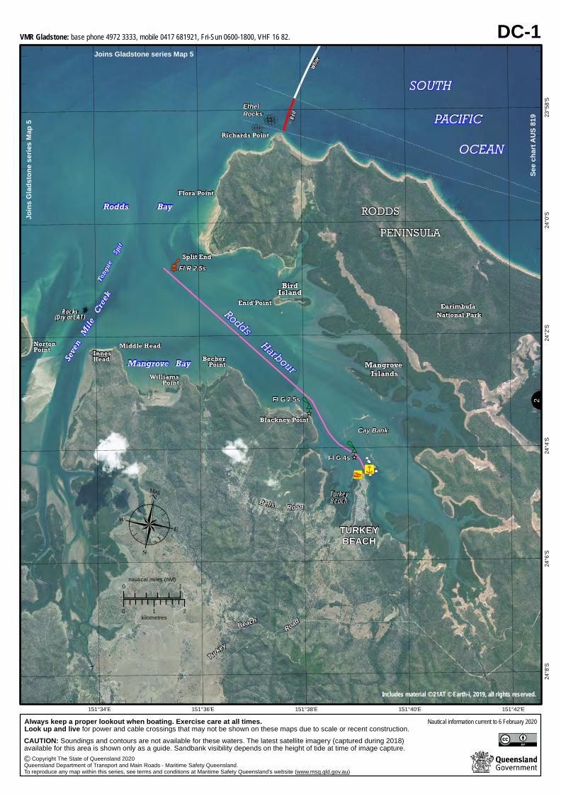
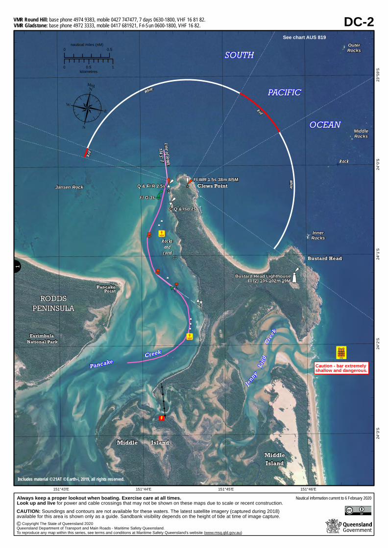
Always keep a proper lookout when boating. Exercise care at all times.Look up and live for power and cable crossings that may not be shown on these maps due to scale or recent construction.
Copyright The State of Queensland 2020Queensland Department of Transport and Main Roads - Maritime Safety Queensland.To reproduce any map within this series, see terms and conditions at Maritime Safety Queensland's website (www.msq.qld.gov.au)
CAUTION: Soundings and contours are not available for these waters. The latest satellite imagery (captured during 2018) available for this area is shown only as a guide. Sandbank visibility depends on the height of tide at time of image capture.
VMR Gladstone: base phone 4972 3333, mobile 0417 681921, Fri-Sun 0600-1800, VHF 16 82.
VMR Gladstone: base phone 4972 3333, mobile 0417 681921, Fri-Sun 0600-1800, VHF 16 82.VMR Round Hill: base phone 4974 9383, mobile 0427 747477, 7 days 0630-1800, VHF 16 81 82.
See chart AUS 819
¶Mag
AP
P
P
PPP
PP
PP
PP
PP
PP
PP
PP
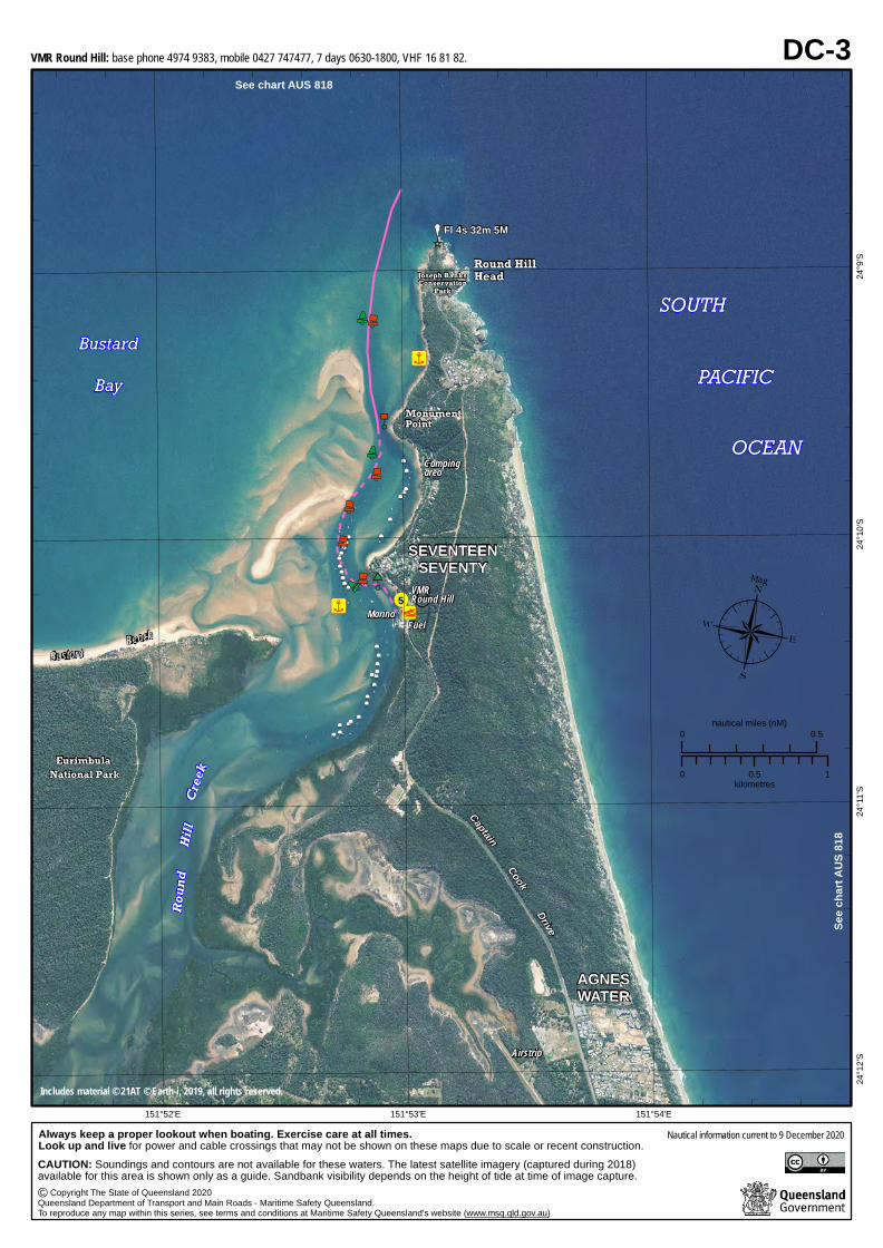
Always keep a proper lookout when boating. Exercise care at all times.Look up and live for power and cable crossings that may not be shown on these maps due to scale or recent construction.CAUTION: Soundings and contours are not available for these waters. The latest satellite imagery (captured during 2018) available for this area is shown only as a guide. Sandbank visibility depends on the height of tide at time of image capture.
VMR Round Hill: base phone 4974 9383, mobile 0427 747477, 7 days 0630-1800, VHF 16 81 82.See chart AUS 818
See c
hart
AUS 8
18
¶Mag
AP
P
P
P
PP
PP
PP
PP
PP
PP
PP
PP
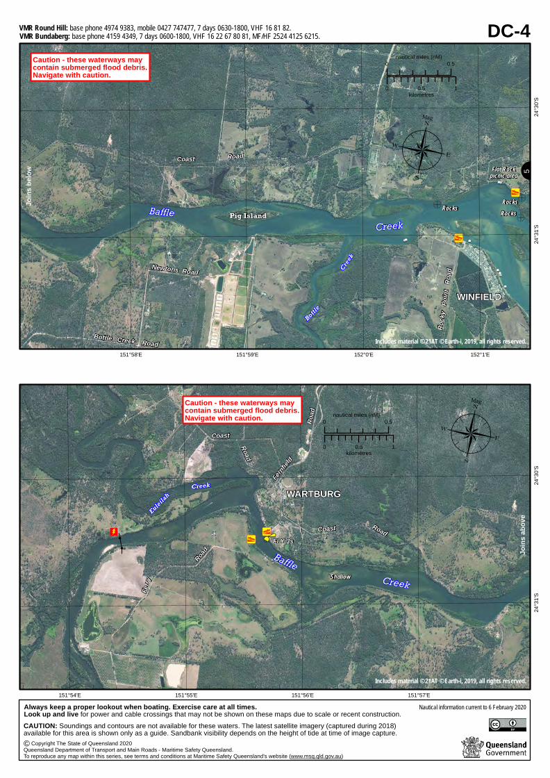
Always keep a proper lookout when boating. Exercise care at all times.Look up and live for power and cable crossings that may not be shown on these maps due to scale or recent construction.CAUTION: Soundings and contours are not available for these waters. The latest satellite imagery (captured during 2018) available for this area is shown only as a guide. Sandbank visibility depends on the height of tide at time of image capture.
Copyright The State of Queensland 2020Queensland Department of Transport and Main Roads - Maritime Safety Queensland.To reproduce any map within this series, see terms and conditions at Maritime Safety Queensland's website (www.msq.qld.gov.au)
VMR Bundaberg: base phone 4159 4349, 7 days 0600-1800, VHF 16 22 67 80 81, MF/HF 2524 4125 6215.VMR Round Hill: base phone 4974 9383, mobile 0427 747477, 7 days 0630-1800, VHF 16 81 82.
¶Mag
AP
P
P
P
PP
PP
PP
PP
PP
PP
PP
PP
¶Mag
AP
P
P
P
PP
PP
PP
PP
PP
PP
PP
PP
Joins
abov
e
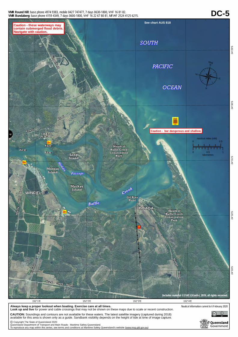
Always keep a proper lookout when boating. Exercise care at all times.Look up and live for power and cable crossings that may not be shown on these maps due to scale or recent construction.CAUTION: Soundings and contours are not available for these waters. The latest satellite imagery (captured during 2018) available for this area is shown only as a guide. Sandbank visibility depends on the height of tide at time of image capture.
Copyright The State of Queensland 2020Queensland Department of Transport and Main Roads - Maritime Safety Queensland.To reproduce any map within this series, see terms and conditions at Maritime Safety Queensland's website (www.msq.qld.gov.au)
VMR Bundaberg: base phone 4159 4349, 7 days 0600-1800, VHF 16 22 67 80 81, MF/HF 2524 4125 6215.VMR Round Hill: base phone 4974 9383, mobile 0427 747477, 7 days 0630-1800, VHF 16 81 82.
¶Mag
AP
P
P
P
PP
PP
PP
PP
PP
PP
PP
PP
See chart AUS 818
Always keep a proper lookout when boating. Exercise care at all times.Look up and live for power and cable crossings that may not be shown on these maps due to scale or recent construction.CAUTION: Soundings and contours are not available for these waters. The latest satellite imagery (captured during 2018) available for this area is shown only as a guide. Sandbank visibility depends on the height of tide at time of image capture.
Copyright The State of Queensland 2020Queensland Department of Transport and Main Roads - Maritime Safety Queensland.To reproduce any map within this series, see terms and conditions at Maritime Safety Queensland's website (www.msq.qld.gov.au)
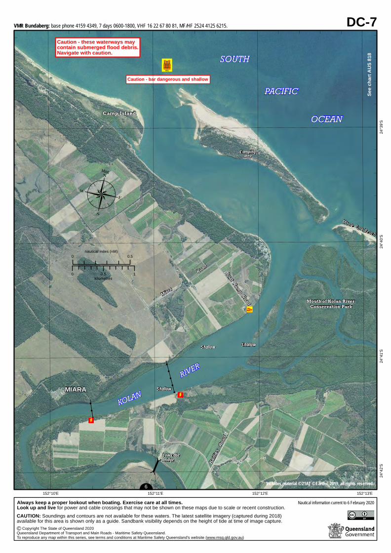
VMR Bundaberg: base phone 4159 4349, 7 days 0600-1800, VHF 16 22 67 80 81, MF/HF 2524 4125 6215.
¶Mag
AP
P
P
P
PP
PP
PP
PP
PP
PP
PP
PP
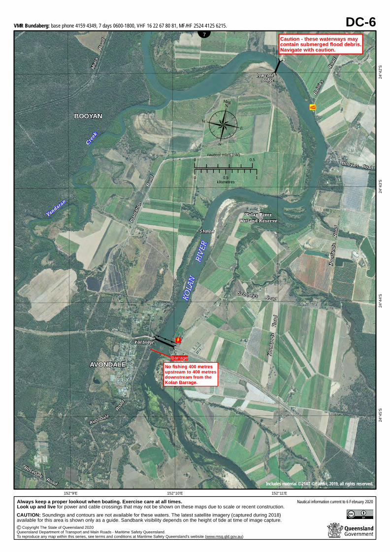
Always keep a proper lookout when boating. Exercise care at all times.Look up and live for power and cable crossings that may not be shown on these maps due to scale or recent construction.CAUTION: Soundings and contours are not available for these waters. The latest satellite imagery (captured during 2018) available for this area is shown only as a guide. Sandbank visibility depends on the height of tide at time of image capture.
Copyright The State of Queensland 2020Queensland Department of Transport and Main Roads - Maritime Safety Queensland.To reproduce any map within this series, see terms and conditions at Maritime Safety Queensland's website (www.msq.qld.gov.au)
VMR Bundaberg: base phone 4159 4349, 7 days 0600-1800, VHF 16 22 67 80 81, MF/HF 2524 4125 6215.
Always keep a proper lookout when boating. Exercise care at all times.Look up and live for power and cable crossings that may not be shown on these maps due to scale or recent construction.CAUTION: Soundings and contours are not available for these waters. The latest satellite imagery (captured during 2018) available for this area is shown only as a guide. Sandbank visibility depends on the height of tide at time of image capture.