BROOKFIELDS / KENSINGTON SWAN Level 9 79 Boulcott Street PO Box 25-306 Featherston Street Wellington Ph +64 4 499 9824 Fax +64 4 499 9822 Solicitors acting: A F D Cameron / F R Wedde / M K Ward Contact: F R Wedde DDI: +64 4 498 0847 Email: [email protected]Before a Board of Inquiry Basin Bridge Proposal Under the Resource Management Act 1991 (the Act) In the matter of a Board of Inquiry appointed under section 149J of the Act to consider the New Zealand Transport Agency's notice of requirement and five resource consent applications for the Basin Bridge Proposal. Fourth Statement of Supplementary Evidence of David James Dunlop for the New Zealand Transport Agency (Transportation) 22 May 2014
Travel Time Benefits Congestion Relief Vehicle OperatingCosts
Co2 Benefits Trip Reliability PT Pedestrian and CycleBenefits
Safety Benefits
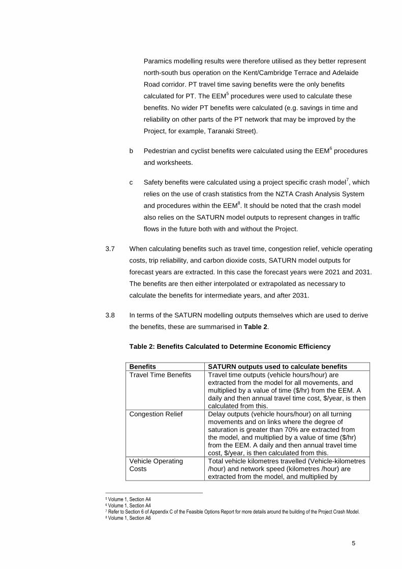
3.6 Benefits that are calculated by other means for this Project (that is, without using
SATURN outputs), are summarised as follows:
a PT benefits do not rely on SATURN outputs. Using SATURN outputs for this
purpose is not appropriate as SATURN does not model the bus network
operation in enough detail to extract such benefits (e.g. bus pre-signals and
other operational characteristics can’t be accurately modelled in SATURN).
4 Selwyn Blackmore, evidence in chief, from paragraph 2.11.
5
Paramics modelling results were therefore utilised as they better represent
north-south bus operation on the Kent/Cambridge Terrace and Adelaide
Road corridor. PT travel time saving benefits were the only benefits
calculated for PT. The EEM5
procedures were used to calculate these
benefits. No wider PT benefits were calculated (e.g. savings in time and
reliability on other parts of the PT network that may be improved by the
Project, for example, Taranaki Street).
b Pedestrian and cyclist benefits were calculated using the EEM6
procedures
and worksheets.
c Safety benefits were calculated using a project specific crash model7, which
relies on the use of crash statistics from the NZTA Crash Analysis System
and procedures within the EEM8. It should be noted that the crash model
also relies on the SATURN model outputs to represent changes in traffic
flows in the future both with and without the Project.
3.7 When calculating benefits such as travel time, congestion relief, vehicle operating
costs, trip reliability, and carbon dioxide costs, SATURN model outputs for
forecast years are extracted. In this case the forecast years were 2021 and 2031.
The benefits are then either interpolated or extrapolated as necessary to
calculate the benefits for intermediate years, and after 2031.
3.8 In terms of the SATURN modelling outputs themselves which are used to derive
the benefits, these are summarised in Table 2.
Table 2: Benefits Calculated to Determine Economic Efficiency
Benefits SATURN outputs used to calculate benefitsTravel Time Benefits Travel time outputs (vehicle hours/hour) are
extracted from the model for all movements, andmultiplied by a value of time ($/hr) from the EEM. Adaily and then annual travel time cost, $/year, is thencalculated from this.
Congestion Relief Delay outputs (vehicle hours/hour) on all turningmovements and on links where the degree ofsaturation is greater than 70% are extracted fromthe model, and multiplied by a value of time ($/hr)from the EEM. A daily and then annual travel timecost, $/year, is then calculated from this.
Vehicle OperatingCosts
Total vehicle kilometres travelled (Vehicle-kilometres/hour) and network speed (kilometres /hour) areextracted from the model, and multiplied by
5 Volume 1, Section A46 Volume 1, Section A47 Refer to Section 6 of Appendix C of the Feasible Options Report for more details around the building of the Project Crash Model.8 Volume 1, Section A6
6
corresponding values (cents per kilometre, and $ perlitre) from the EEM. A daily and then annual traveltime cost, $/year, is then calculated from this
Co2 Benefits The Co2 benefits are calculated based on 4% of thecalculated vehicle operating costs
Trip Reliability Based on the transport model matrix, the benefitsare calculated using traffic volumes, V/C link ratios,intersection types, and use of the EEM
9defined
procedures. The outputs (vehicle hours/hour) aremultiplied by a value of time ($/hr) from the EEM. Adaily and then annual travel time cost, $/year, is thencalculated from this.
3.9 When calculating the benefits the latest version of EEM update factors were
used.
3.10 No wider economic benefits were calculated for the Project in isolation, however,
these benefits were assessed in the Wellington Northern Corridor RoNS
Business Case which increased the BCR from 1.6 to 1.8 for the total package.
4 BCR Calculations presented in my evidence to the Board10
4.1 I can confirm that all of the BCR calculations undertaken and presented in my
Evidence in Chief, Rebuttal Evidence and subsequent supplemental evidence are
based on bespoke network specific SATURN models prepared for the precise
scenario for which a BCR calculation was requested. In other words the SATURN
model network was changed to reflect precisely what improvements were to be
included or excluded (for example, Taranaki Street intersection improvements, 3-
laning of Buckle Street, or 3-laning of Vivian Street, etc).
4.2 In other words BCRs for the disaggregated Project were not calculated by means
of addition and/or subtraction. To do so would be misleading as each network will
behave differently when different elements are added or subtracted from the
model. Accordingly, in transportation economics terms it is entirely reasonable
and expected that the correlation benefits between separate components are
sometimes higher or lower than the combined benefits of those separate
components.
4.3 As has been documented in my EIC11
and Rebuttal12
, the transport models have
also been updated and refined to better reflect current and forecast land use and
associated transport patterns (e.g. 2011 SATURN model revalidation and the
creation of a weekend model). During this time other changes have also occurred
9 Volume 1, Section A4.510 Presented in David Dunlop’s Supplementary Evidence Dated 9 March 2014 and 29 March 201411 Paragraph 6.1712 Paragraph 4.2
7
such as shifts in the Wellington Northern Corridor RoNS programme and changes
to the EEM.
David James Dunlop22 May 2014
8
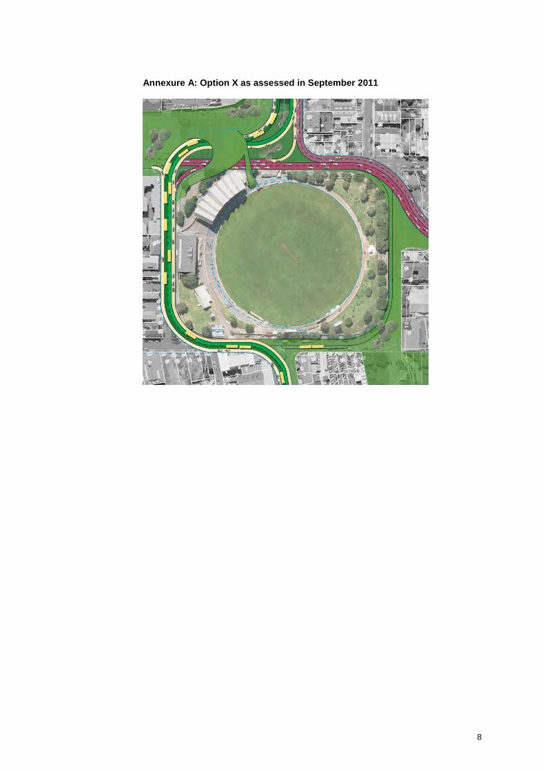
Annexure A: Option X as assessed in September 2011
Annexure B: Opus’s Interpretation of Option X for Architecture Centre Comment in January 2013
9
10
11
12
13
14
15
Annexure C: Option X as assessed in February 2013
16
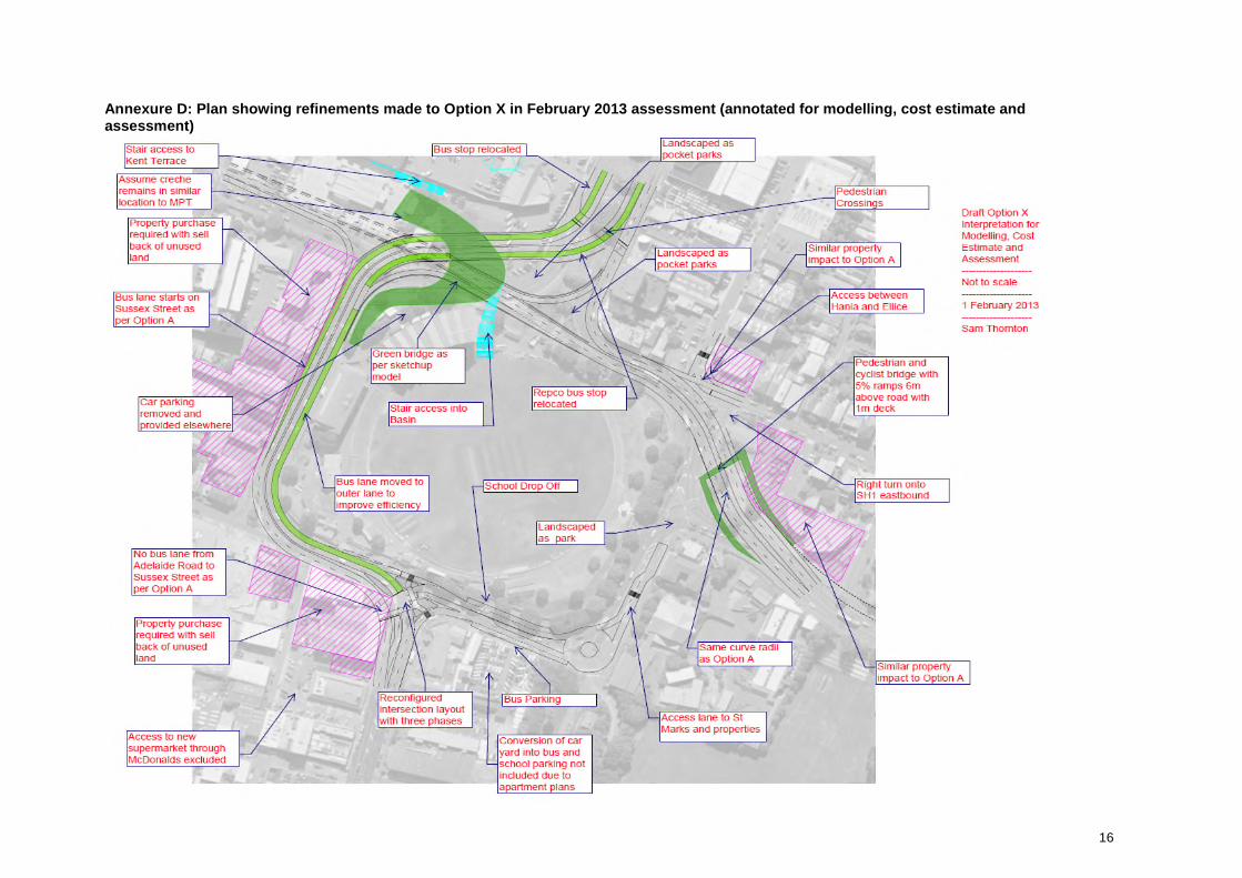
Annexure D: Plan showing refinements made to Option X in February 2013 assessment (annotated for modelling, cost estimate andassessment)