BELLCOMM, INC. GEOLOGIC CHARACTERISTICS OF THE NINE LUNAR LANDING MISSION SITES RECOMMENDED BY THE GROUP FOR LUNAR EXPLORATION PLANNING May 31, 1968 TR-68-340-1 Farouk EI-Baz Work performed for Office of Manned Space Flight, National Aeronautics and Space Administration under Contract NASW-417.
Transcript
BELLCOMM, INC.
GEOLOGIC CHARACTERISTICS OF
THE NINE LUNAR LANDING MISSION
SITES RECOMMENDED BY THE GROUP
FOR LUNAR EXPLORATION PLANNING
May 31, 1968
TR-68-340-1
Farouk EI-Baz
Work performed for Office of Manned Space Flight, NationalAeronautics and Space Administration under Contract NASW-417.
ii
TABLE OF CONTENTS
1
· v
· i v
· vi
...iiiLIST OF ILLUSTRATIONS. .
LIST OF TABLES . . . . . .
ABSTRACT . . . .
SUMMARY. . . .
I. INTRODUCTION. . .
II. CHARACTERISTICS OF THE NINE SITES
1. CRATER CENSORINUS. . . . . . . . 4
2. LITTROW AREA. . . . . 9
3. ABULFEDA (CRATER CHAIN). . 13
4. HYGINUS CRATER AND RILLE. . . . . . . .. . 17
5. APENNINES-RIMA HADLEY. . . .. . 22
6. RIM OF CRATER TYCHO. . . . . . . . . . .. 28
7. CRATER COPERNICUS. . . . . . . . . 32
8. SCHROETER r S VALLEY . . . . .. .... . 40
9. MARIUS HILLS . . . . . 44
III. THE PLAN IN PERSPECTIVE
A.
B.
C.
D.
REFERENCES .
APPENDIX A . .
APPENDIX B .
Summary of the Characteristics .
Mobility Requirements .
Expected Achievements .
Conclusions. .
50
· 51
· 52
· 54
· 59
. . . 60
. . . 61
iii
LIST OF ILLUSTRATIONS
Page
.16
.20
. .21
Hyginus Crater and Rille . · . · .
Proposed Landing Site for Hyginus Craterand Rille. . . . . . .
Proposed Landing Site in the Littrow Area 12
Abulfeda (Crater Chain). . 15Proposed Landing Site for Abulfeda(Crater Chain) . . . . . .
Index Map (The Nine GLEP Sites). . . . .. 3
Crater Censorinus. . . . . . . . . . '7
Proposed Landing Site for Crater Censorinus.. 8Littrow Area. . . . . . . .11
Figure 1.
Figure 2a.
Figure 2b.
Figure 3a.
Figure 3b.
Figure 4a.
Figure 4b.
Figure Sa.
Figure Sb.
Figure 6a.
Figure 6b.
Figure 6c.
Figure 7a.
Figure 7b.
Figure Sa.
Figure 8b.
Figure Sc.
Figure 9a.
Figure 9b.
Figure lOa.
Figure lOb.
Figure lOco
Apennines-Rima Hadley. ... .....25
Proposed Landing Sites for the Apennines-Rima Hadley. . . . . . . .26
Four Possible ULRV 500 km Traverses. . .27
Rim of Crater Tycho. . . .30
Proposed Landing Site on the Rim of CraterTy ch o , . . . . . . . .. . 31
Crater Copernicus. . . . . . .36
Proposed Landing Site for the Central Peak ofCrater Copernicus 37
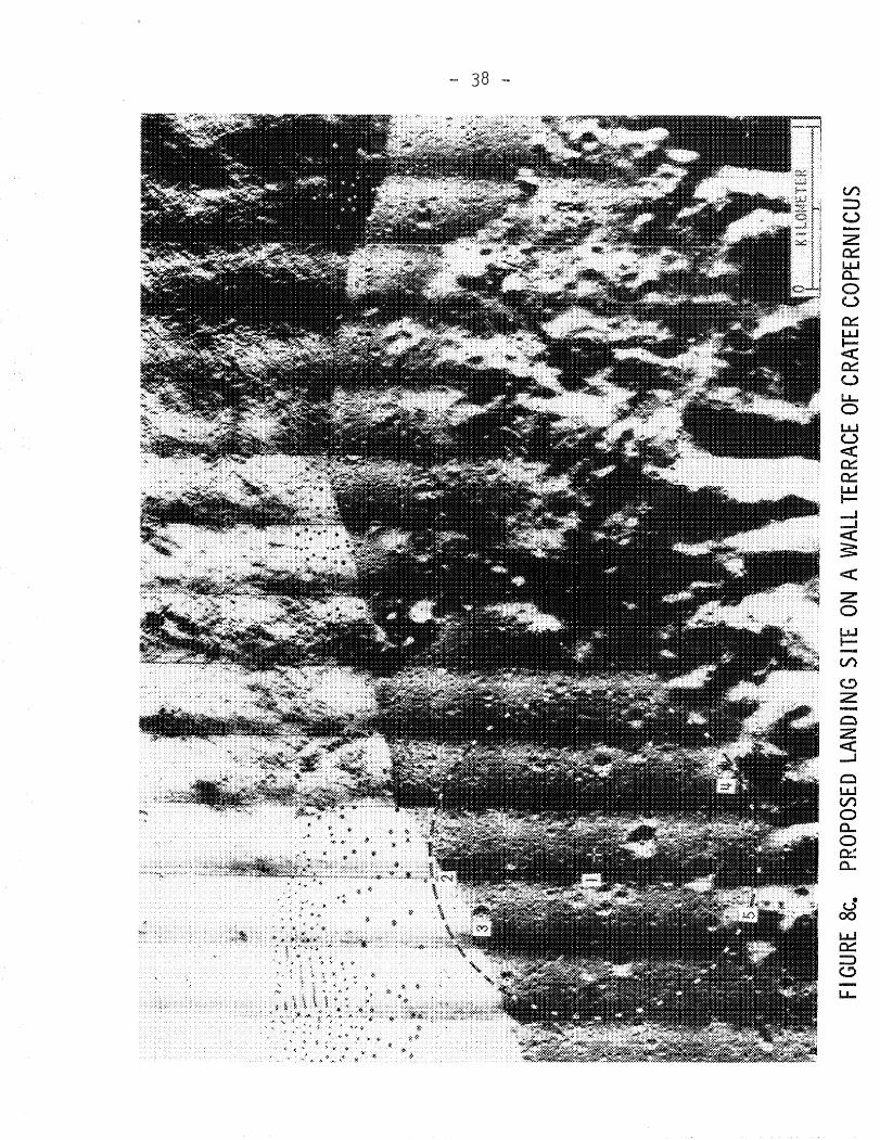
Proposed Landing Site on a Wall Terrace ofCrater Copernicus. . . . . . . . . .38
Figure 8d. Proposed Landing Site for the Walland Floorof Crater Copernicus. . . . . .39
Schroeter's Valley. .. . 42
Proposed Landing Sites for Schroeter's Valley.43
Marius Hills. . . . . . . . . . .47
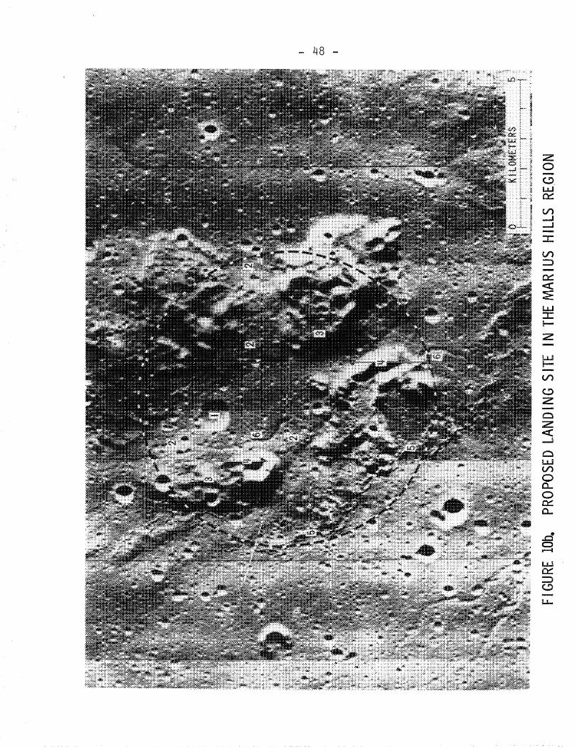
Proposed Landing Site in the Marius HillsRegion . . . . . . . .. .........48
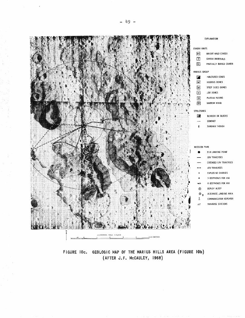
Geologic Map of the Marius Hills Area(Figure lOb), after J. F. McCauley, 1968. .49
iv
LIST OF TABLES
Table I. Cumulative Graph of the Characteristicsand Structural Features of the Areas toto be Explored in the Nine Sites .. .55
Table II. Preference of Mobility Aids for the Nine(GLEP) Sites. . ...
Table III. Phases of the Lunar Exploration Plan.
. .56
.57
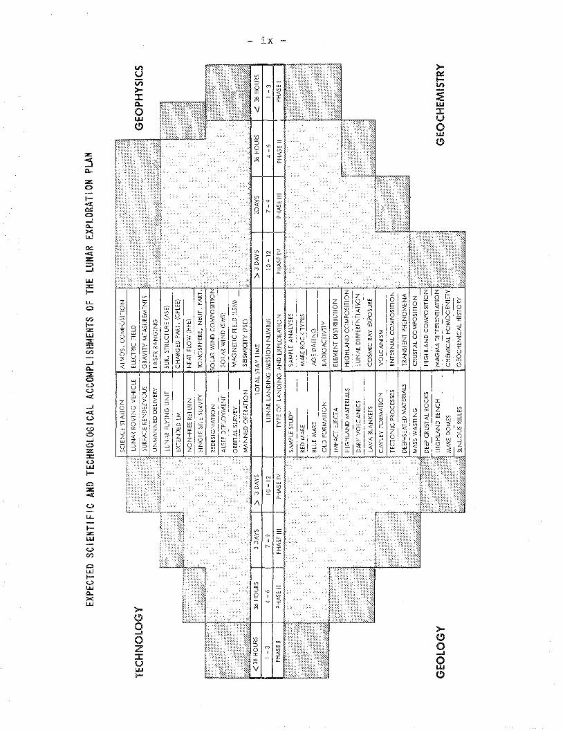
Table IV. Expected Scientific and TechnologicalAccomplishments of the Lunar ExplorationPlan 58
v
ABSTRACT
The Group for Lunar Exploration Planning (GLEP)selected nine sites for manned surface exploration missions;Crater Censorinus, Littrow Area, Abulfeda (Crater Chain),Hyginus Crater and Rille, Apennines-Rima Hadley, Rim of CraterTycho, Crater Copernicus, Schroeter's Valley, and Marius Hills.These nine sites are analyzed in this report. Emphasis is putlargely on the geologic setting of the areas in question.However, some technological problems are considered. A summaryof this analysis is given on the following pages.
The report provides a base for future discussionsof the Lunar Exploration Plan in general. The data and information provided in Chapter II, which deals with the characteristics of the individual sites, will be of value in the firststages of future mission planning.
vi
SUMMARY
Nine areas on the Moon's earthside were recommendedby the Group for Lunar Exploration Planning (GLEP) for mannedsurface exploration missions, with the un~erstanding that theywould be preceded by three missions- to two different mare anda site in the Fra Mauro Formation. These nine sites and theirsalient features are:
1. Crater Censorinus: A small, fresh (impact) crater inhighland terrain, on the projected outer rim of MareNectaris, or the southern rim of Mare Tranquillitatis.
2. Littrow Area: Very dark (volcanic) blanket materialwhich mantles both Serenitatis Bench rocks and afresh mare ridge.
3. Abulfeda (Crater Chain): (Deep-seated) material in andaround a (volcanic) crater chain in the SouthernHighlands and its associated "cinder cones".
4. Hyginus Crater and Rille: The floor of crater Hyginus,the walls of its linear rille, and the surroundingplains which include the Cayley Formation.
5. Apennines - Rima Hadley: The Apennine mountain front,its contact with the mare and relationship to a youngsinuous rille, and the controversial crater Hadley C.
6. Rim of Crater Tycho: Textures and structures of partof the rim of a large rayed crater in highland terrain.
7. Crater Copernicus: The (deep-seated) rocks at the centralpeaks, the floor, and the flow, mass wasting featuresand ponds along the walls.
8. Schroeter's Valley: A large lunar valley, its mediansinuous rille, and their genetic relationships to the"Cobra Head", and the latter's transient phenomena.
9. Marius Hills: A complex of (volcanic) domes, cones,mare ridges and sinuous rilles in Oceanus Procellarum.
Chapter II of this report includes discussions of thenine sites, namely: descriptions of the general and geo10gicsettings of the areas in question; listings of the major objectivesand the scientific merits of the sites; and a proposal of alanding point and consequent surface operations for each site.Many of the discussions are based on scientific-geologic considerations; reference is made, however, to some engineering andtechnological problems involved.
vii
Three of the nine sites, Crater Censorinus, LittrowArea, and Abulfeda (Crater Chain), were previously consideredas candidates for "wa Lkl ng missions", .i • e., no mobili ty aidsto be used in the 1.5 km radius of operations, with the Littrowsite being a borderline case. Preliminary photo-geologic studiesindicate that both Censorinus and Littrow sites may be consideredfor "walking missions". The Abulfeda site, however, requiresthe extension of the mobility range to at least 5 km in orderto achieve all of the mission objectives. It was also foundthat a "walking mission" to the rim of crater Tycho, and in thevicinity of the Surveyor VII spacecraft, would achieve almostall of the objectives of studying this crater. Explorationplans for the rest of the sites, however, require one or moreof the mobility aids now under consideration (Lunar FlyingUnits, Field Assistants, Manned and Unmanned Lunar RovingVehicles) .
In Chapter III of the report, an analysis of theGLEP plan in toto is given. This analysis includes a summaryof the characteristics of the nine sites and the nature of theareas to be explored (as given on p. viii), a. summary of themobility requirements based on the objectives of a given missionand the nature of the t~rrain to be explored, and an array of theexpected achievements in the fields of technology, geology,geophysics and geochemistry, as shown on p. ix.
It is concluded that the GLEP plan, including thefirst thre~ Apollo missions, constitutes a well balanced selection of scientifically important areas. It is also concludedthat the exploration of the selected sites should broaden ourknowledge of the Earth-Moon system and give clues to majorquestions concerning the Moon including: 1) The chemicalheterogeniety of lunar rocks, 2) The differentiation of the Moonas a whole and that of lunar magmas, 3) Extra~lunar processesand cratering events and their frequency 4) Geophysical prop~
erties of the Moon, and 5) The ge8chemical (organic and inorganic)history of the near lunar environment.
GEOLOGIC· CHARACTERISTICS OFTHE NINE LUNAR LANDING MISSIONSITES RECOMMENDED BY THE GROUPFOR LUNAR EXPLORATION PLANNING
I. INTRODUCTION
In August, 1967, at Santa Cruz, California, NASAsponsored a Summer Study of Lunar Science and Exploration.During that conference, it became obvious to the participantsthat the selection of many lunar scientific experiments andthe establishment of operational requirements (lunar stay time,mobility aids, etc9) were site-dependent. It was necessary,therefore, that before commencing detailed planning, one shouldspecify the sites. In response to this need, a Site SelectionSubgroup (Appendix A) of the Group for Lunar Exploration Plan-ning (GLEP)* met on December 9, 1967 to select targets ofsalient value in the quest for understanding many of the majorlunar surface units and features, their origin, evolution, andmodifying processes. Nine areas on the lunar earthside wereselected and are shown on the index map of Figure 1. The numbers assigned to these nine sites are neither indicative ofpriorities, nor do they correspond to a time sequence, althoughthe first three (Censorinus, Littrow, Abulfeda) were considered as sites where no mobility aids would be available. Furtherstudy is required before establishing priority and sequence.
It was understood that manned missions to the ninesites would follow three Apollo flights to mare regions orother smooth terrain units, thus, making a total of 12 missionsin this exploration plan. Sites for the first three missions,dictated primarily by engineering considerations, are notdiscussed here other than to say that it would be scientificallyadvantageous to land one each in an eastern mare, a westernmare, and an "o I d " surface uni t, preferably the Fra MauroFormation.
*The GLEP, composed of representatives of the disciplinaryworking groups at Santa Cruz, is a continuing advisory bodyreporting to Dr. W. N. Hess, Director of Science and Applicationsat the Manned Spacecraft Center.
BELLCOMM, INC. - 2 -
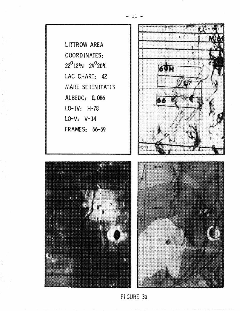
In the following section of this report, the nineGLEP sites are described separately. Descriptions of theindividual sites are supplemented by explanatory figures.In all cases, one part of a given figure (part "al!) is devotedto basic data pertaining to the site, including:
1. Data relevant to the location of the site (coordinatesof LO-V camera axis intercepts on the lunar surface),the corresponding LAC chart number and designation,average albedo of the area, LO-IV frame number, andLO-V site and frame numbers.
2. A reproduction of the footprint of LO-V photographiccoverage keyed to the corresponding LAC chart.
3. A medium resolution photograph depicting the siteand its relationships to the surrounding terrain.
4. A reproduction of the available USGS geologic mapof the area. This part is lacking in the case ofTycho where no geologic maps are available yet.*
Part 11a" of any given figure is followed by one ormore parts where the landing point and area of surface operations are specified. Targets of specific interest are alsoenumerated, making the figures useful for future detailedstudies and drafting of mission plans.
*See Appendix B for explanation of the lunar stratigraphicsystems and the origin of the geologic symbols.
APENNINES-RIMA HADLEYRIM OF CRATER TYCHOCRATER COPERNICUSSCHROETER is VALLEYMARl US sius
BELLCOMM, INC. - 4 -
II. CHARACTERISTICS OF THE NINE SITES
1. CRATER CENSORINUS
A. Description and Setting*
The crater Censorinus is a small (3.5 km in diameter)but very bright and young crater, with a high thermal anomaly,named after the Latin grammarian and mathematician. It lieson the northwestern edge of a highland plateau between MareTranquillitatis and Mare Nectaris, being closer to the former.
The plateau itself appears to be part of a raisedring concentric with the Nectaris Basin, N-NE of a continuationof the Altai Scarp. This plateau is probably made of either1) primitive lunar material which has undergone little or nochemical change since the formation of the Moon; or 2) Nectarisejecta which mayor may not be covered by younger materials.
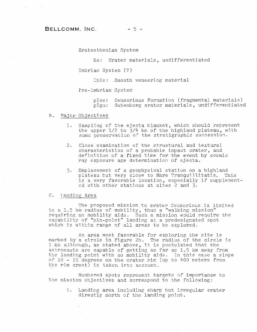
The morphology of the crater Censorinus and itsconspicuous effects on and modifications of the surroundingterrain suggest that it is most probably an impact feature.As illustrated in Figure 2a (lower left), the crater is characterized by a round, sharp rim crest and a very distinct patternof ejecta. As will be discussed later, it is also characterizedby a great abundance of fresh large blocks in th~ vicinity ofits rai~)ed riB which account for the high thermal anomalydisplayed by the crater. Many of these ejected blocks haveimpacted on the mantled wall of the neighboring crater CensorinusA, leaving marked imprints.
The geologic units represented in the area of the
crater Censorinus (Figure 2a: lower right) are as follow: l
*This section includes information which is contributed byMessrs. John W. Dietrich and Harrison H. Schmitt of MSC; memQersof the GLEP Site Selection Subgroup (Appendix A).
1. Sampling of the ejecta blanket, which should representthe upper 1/2 to 3/4 km of the highland plateau, withsome preservation of the stratigraphic succession.
2. Close examination of the structural and texturalcharacteristics of a probable impact crater, anddefinition of a fixed time for the event by cosmicray exposure age determination of ejecta.
3. Emplacement of a geophysical station on a highlandplateau but very close to Mare Tranquillitatis. Thisis a very favorable location, especially if supplemented with other stations at sites 2 and 3.
c. Landing Area
The proposed mission to crater Censorinus is limitedto a 1.5 km radius of mobility, thus a llwalking mission tl
requiring no mobility aids. Such a mission would require thecapability of f1pin-point" landing at a predesignated spotwhich is within range of all areas to be explored.
An area most favorable for exploring the site ismarked by a circle in Figure 2b. The radius of the circle is1 km although~ as stated above, it is postulated that theastronauts are capable of getting as far as 1.5 km away fromthe landing point with no mobility aids. In this case a slopeof 10 - 15 degrees on the crater rim (up to 400 meters fromthe rim crest) is taken into account.
Numbered spots represent targets of importance tothe mission objectives and correspond to the following:
1. Landing area including sharp but irregular craterdirectly north of the landing point.
BELLCOMM, INC. - 6 -
2. Blocks of rock, on the ejecta blanket, and their surroundings.
3. The sharp rim crest of the crater itself and theview of the inside wall and its characteristics.
4. Patterns of the ejecta blanket as far as possiblefrom the rim crest, including a small, sharp, raised,dark-haloed and round crater.
An alternative landing point lies west of the craterCensorinus and is marked X in Figure 2b. However, in this case,Censorinus would be an obstacle from the engineering (approachpath) viewpoint.
CRAT
ERC
ENSO
RIN
US
COO
RDIN
ATES
:0°
361
532
°43I
E
LAC
CHAR
T:79
COLO
MBO
ALBE
DO:
0"19
8LO
-IV:
H-7
3
lO-V
:v~
12FR
AME:
63
FIGU
RE2a
8
V)
:::>z-~
oV')
ZLLJU
~UJ
<e::::uc::::oI.J...,
LLJI--V'l
~
:zo:z«......J
cI..LJV')
oa...o0:::c,
BELLCOMM, INC.
2. LITTROW AREA
- 9 -
A. Description and Setting
Rimae Littrow constitute one part of a series ofrille networks around the margin of Mare Serenitatis and lieclose to its eastern edge. Associated with the rille systemsare low albedo blanketing materials which, in the vicinity ofLittrow, include some of the darkest material on the lunarsurface.
The dark materials occur mostly on a level crateredplateau, here called the Serenitatis Bench, between typicalmare to the west and rugged uplands to the east. However,part of the mare and uplands in the immediate vicinity of theplateau are anomalously dark.
The Littrow area is also characterized by an abundanceof fresh looking wrinkle ridges in the mare. Mare Serenitatisin this area is also characterized by a number of minute cracksforming systems subparallel to the ridges, and thus, appears tobe a stage in wrinkle ridge formation. In one spot, the darkblanketing material conspicuously covers part of a fresh ridge,which suggests that the dark material is relatively young andmay be of volcanic origin.
The geologic units represented in the Littrow area
(Figure 3a; lower right) include the following: 2
Copernican System
Cc: Crater material, undifferentiatedCs: Slope material (freshly generated talUS)
Eratosthenian System
Ec:Emd:
Crater materials, undifferentiatedMare material, dark
Imbrian System (Archimedian Series)
Ipm3 :Ipm4:
B. Major Objectives
Mare material (volcanic); albedo 0.061-0.062Mare material (volcanic); albedo 0.060-0.061
1. Study and sampling of the dark mantling materialassociated with Rimae Littrow. The low albedo of
BELLCOMM, INC. - 10 -
these rocks may be due to a distinctive chemicalcomposition, a form of alteration, or a thinveneer of dark material such as carbon.
2. Sampling of the lighter materials of the bench,mare, and mare ridge, and the study of their relationships to the dark mantling material.
3. Study of the structural characteristics of the mare(wrinkle) ridge which is one of the freshest in allthe proposed sites including those suggested for thefirst three Apollo missions.
4. Study and sampling of the variably subduedcraters on the mare surface, on the bench and thedark mantling material. This should yield significantinformation on the origin of craters and theirgeometric characteristics.
5. Geophysical investigations of the subsurface structurebeneath the Maria of Serenitatis and Tranquillitatisand their adjacent highlands.
c. Landing Area
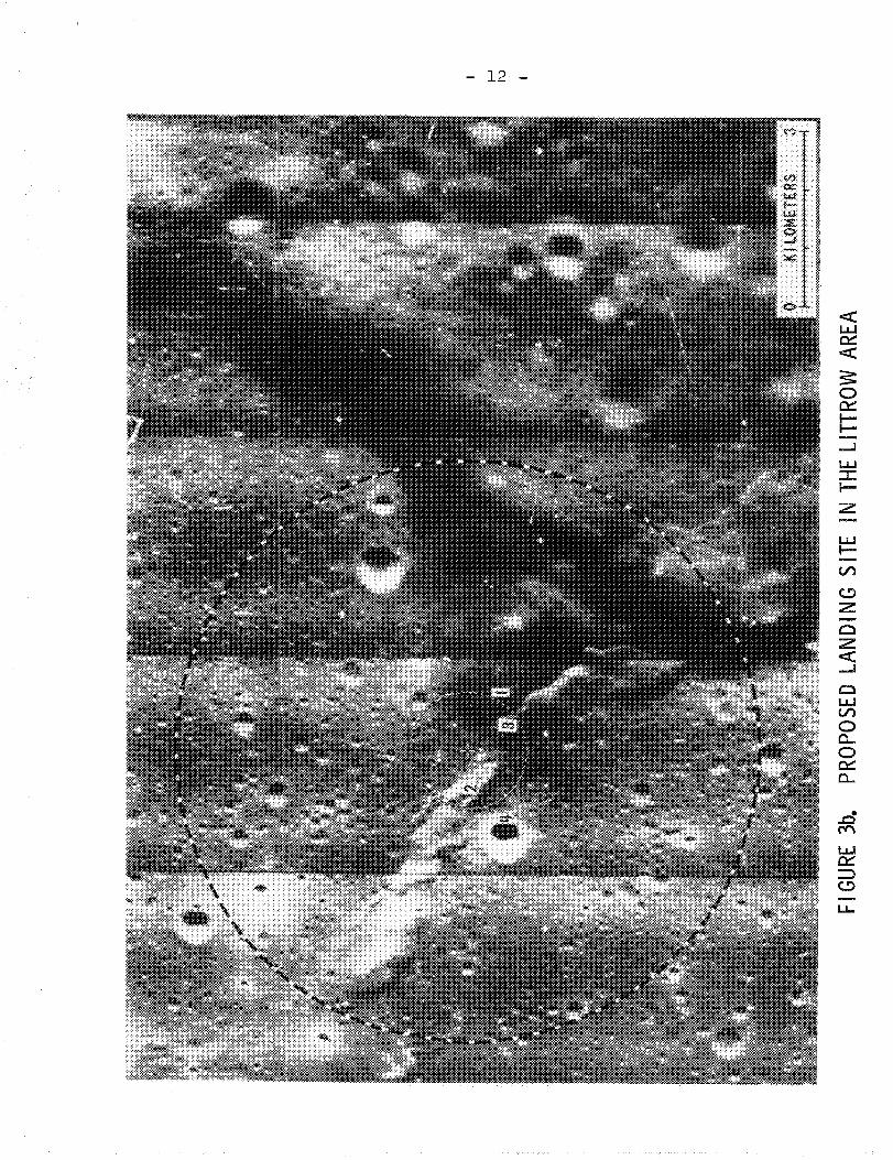
As illustrated in Figure 3b, there are two alternativesfor exploring the Littrow area, one without the use of mobilityaids and the other utilizing such aids to expand the explorationlimit from 1.5 km to 5 ~m from the landing point.
From the illustration, it is obvious that most targetsof interest could be reached in a "walking mission" to this area.The only dubious matter would be encountering Serenitatis Benchmaterial. However, it should be possible to do that by shallowdrilling 1.5 km E-SE of the designated landing point. It shouldbe kept in mind that the smaller circle in the figure is 2 kmand not 3 km in diameter, and the larger circle is 10 km indiameter.
The numbered targets in Figure 3b correspond to:
1. Dark mantling material underlain by bench material
2. Fresh wrinkle ridge in mare
3. Mare ridge covered by the dark mantling material
4. A relatively large, fresh crater in mare.
LITTROW AREA
COORDINATES:
22012'N 29°20IE
LAC CHART: 42
MARE SERENJTATIS
ALBEDO: 00086
LO"'IV: H·78
LO....V: V·14
FRAMES: 66-69
- 11 -
FI GURE 3a
FIGU
RE3b
.PR
OPO
SED
LAN
DIN
GSI
TEIN
THE
LITT
ROW
AREA
f-'
f\)
BELLCOMM, INC. - 13 -
3. ABULFEDA (CRATER CHAIN)
A. Description and Setting
The crater Abulfeda is situated in southern highlandterrain and is surrounded by presumably old terra in alldirections, with the nearest mare being over 200 km away. Thecrater is about 50 km in diameter and displays a circular terraced wall which rises up to 3 km above its floor.
A remarkable crater chain, the longest on the Moon'searthside, runs tangentially to Abulfeda's southern rim, whereAbulfeda T and Abulfeda X form part of the chain. The chaincan be traced for more than 150 km to the southeast where itcuts across the Altai Scarp.
The geometric relationships between the crater chainand crater Abulfeda do not reveal their genetic relationships,if any. However, the chain itself bears similarities to certain volcanic crater chains on earth, and by analogy, it ispossible that one may encounter deep-seated rocks at this site.
A preliminary geologic map of the area is provided 3in Figure 4a where the geologic units are classified as follows:
Copernican System
Ccr:Cs :
Crater rim material, undifferentiatedSlope material (freshly generated talus)
Imbrian System
Ifm?: Fra Mauro FormationIn: Plains-forming materialInt: Thin plains-forming material
B. Major Objectives
1. From the geologic and geochemical viewpoints, it ismost important to examine and sample Iftypical"southern highland material, an unclassified and littleunderstood unit covering more than 30% of the Moon'searthside. The coarsely-patterned ground at this siteis typical of a good portion of the southern highlands.The comparison of this with "freshlyf' exposed terra,such as that in the Censorinus and Tycho sites, wouldprovide valuable data on the composition of the terrae,
BELLCOMM, INC. - 14 -
their aging processes and the nature of the lunarnear-surface environment.
2. The origin of the Abulfeda crater chain most probablyinvolved deep-seated volcanic-tectonic processes.One would expect that the study of returned samplesfrom this site would give some answers to major questions concerning the differentiation of lunar materialsat depth. Furthermore, close examination of thecharacteristics of the area may shed light on lunarvolcanism and the formation of volcanic crater chainsin general.
3. Emplacement of a geophysical station. The simultaneousoperation of observatory-type geophysical stations atLittrow area and the craters Censorinus and Abulfeda(and possibly also at Tycho) would result in a welldistributed network.
c. Landing Area
The Abulfeda (crater chain) site was originallyproposed by the Site Selection Subgroup for a "walking mission",i.e., maximum mobility radius of 1.5 km. From Figure 4b it isclear that such a mission would allow the astronauts to studythe landing area, its textural patterns and the various smallcraters peppered on the surface (numbers 1 through 3), up tothe edge of the duct connecting Abulfeda T and Abulfeda X(number 4).
A very important feature in this area is the abundanceof dark "cinder cones" inside the chain. The floors of, andthe connecting rille between, Abulfeda T and Abulfeda X displayseveral of those crater cones. At A (to the lower right), onemajor cone with a round sharp summit crater is surrounded byseveral secondary cones, most of which display a well developed summit crater. At A' (to the lower left) two distinct coneswith summit craters are also conspicuous. These "cinder cones"constitute a major feature of interest and a mission to thiscrater chain should be extended to 5 km mobility, e.g., utilizing Lunar Flying Units, to reach, sample and study the clustermarked A in Figure 4b.
ABUL
FEDA
(CRA
TER
CH
AIN
)
COO
RDIN
ATES
:14
°50.
514
000'
E
LAC
CHAR
T:78
THEO
PHIL
US
ALBE
DO:
D.14
8LO
-IV:
'H-8
9
LO"'V
:V.
..19
FRAM
E:84
FIGU
RE4a
- 16
-Z<C::cu0:::
~0:::U-
u...
BELLCOMM, INC. - 17 -
4. HYGINUS CRATER AND RILLE
A. Description and Setting
Named after the Spanish astronomer, the crater Hyginusis some 10 km in diameter with a very low rim and numerous smalldomal masses on its floor. A great cleft, Rima Hyginus, branchesfrom the crater at two points, trending toward the northwestand east-southeast. The cleft, a well developed linear rille,is characterized by an abundance of crater chains. The latterare composed of low-rimmed craters closely associated with therille and, thus, appear to have been a result of endogeniclunar processes rather than an external (meteroid impact)origin. The morphology of the craters suggests that they arevolcanic craters of a type (maar) that on Earth commonlyproduces erupted materials from deep within the crust or mantle.Similar, but not identical situations, exist at the Abulfedasite, as well as at the Davy G crater chain.
Near the rim of the crater Hyginus is a contactbetween two units (one dark, one light) of smooth plains-formingmaterials which surround the.crater. Although both units havenumerous rimless depressions of possible collapse origin, thelow total density of craters indicates a relatively young age.The smooth, light material, designated the Cayley Formation(Icy in Figure 5a, lower right), may be: 1) an old regionalunit of unknown origin in which the crater Hyginus and itsassociated rille system were formed; or 2) a deposit of materials which originated from the crater and rille. The smoothdark material appears to overlie the Cayley Formation. Itcould have originated from the elor:gate crater on the northernrim of crater Hyginus through volcanic processes.
The stratigraphic units represented in the area
include: 4
Copernican System
Cc: Crater material, undifferentiatedCs: Slope material
Copernican-Eratosthenian
CEc: Crater material, indeterminate stratigraphic position
Eratosthenian System
Ec: Crater material, undifferentiated
BELLCOMM, INC.
Imbrian System
- 18 ..,.
Archimedian Series
Ipd? :Icy:
Dome materialCayley Formation
Apenninian Series
Ifm: Fra Mauro Formation
B. Major Objectives
1. Examination of the physical and chemical heterogenietyof materials that constitute two important units ofthe lunar crust. These two units (the Cayley Formationand the dark overlying rock) are probably different,compositionally, from both typical mare and typicalhighlands.
2. Sampling of what may prove to be deep-seated lunarrocks in and around the crater chains associated withRima Hyginus.
3. Examination and sampling of the wall and floor ofthe crater Hyginus itself to unravel its origin andthe nature of the domal structures on its floor aswell as the abundant rock ledges on its wall.
4. Examination of the structural characteristics of awell-developed linear rille and its role in thetectonic history of the area.
5. The spatio-temporal relationships of the many volcanic features and materials in this site would shedsome light on the presence or effects of lunar effluents and the local evolution of volcanic processesin the lunar environment.
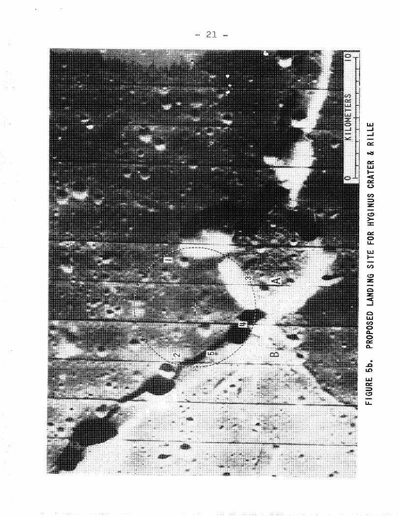
c. Landing Area
A 5 km mobility radius of surface operations wastentatively set for the mission to the Hyginus site as well asall the following sites. The circle in Figure 5b representsthe limit of mobility in all directions from a favorable landing point from both the scientific and engineering viewpoints.
BELLCOMM, INC. - 19 -
Numbers within the circle in Figure 5b denote thefollowing:
1. Dark mantling material of probable volcanic origin
4. Rimless (maar) crater, a part of a discontinuouscrater chain
5. Walls and floor of a straight linear rille (RimaHyginus)
If feasible from the engineering viewpoint, twoalternative landing points are: A) on the floor of craterHyginus itself, and closer to its western rim; B) due westfrom the center of crater Hyginus, and on typical terrain ofthe high-albedo, plains-forming unit tentatively called theCayley Formation. The terrain south of the crater Hyginusappears to be very favorable because of its smoothness.However, it would be rather difficult to land there and stillreach the targets of scientific interest within the presentmobility range limitations.
HYG
INU
SCR
ATER
&R
ILLE
CO
OR
DIN
ATES
:g0
031
N600
Q'E
LAC
CHAR
T:59
MAR
EV
APO
RU
M
ALBE
DO:
0011
7LO
-IV
:H
-I02
LO-V
:V
-23.
.2FR
AMES
:94
-97
FIGU
RESa
f\) o
FIGU
RE5b
aPR
OPOS
EDLA
NDJN
GSI
TEFO
RHY
GINU
SCR
ATER
&RI
LLE
f\)
!--I
BELLCOMM, INC.
5. APENNINES-RIMA HADLEY
- 22 -
Ccr:Cs :Cs c:Cscl:
A. Description and Setting
The Apennine Mountains constitute by far the mostimposing of the lunar mountain ranges, and form the southeastern boundary of Mare Imbrium. They form the base of atriangle-shaped elevated highland region between Mare Imbrium,Mare Serenitatis and Mare Vaporum. At the area of the proposedsite, the mountain front rises 1,280 meters above the adjacentmare level to the west, i.e., the southeastern portion of PalusPutredinis.
Rima Hadley is a V-shaped sinuous rille which terminates to the south at an elongate depression (lower leftcorner in the LO-IV photograph in Figure 6a) and runs in anortheasterly direction, parallel with the Apennine front,for over 50 km until it merges with Rima Fresnel II to thenorth. Fresh exposures, possibly of stratified mare beds,occur along the top of the rille walls from which numerousblocks have rolled down the walls to settle on the floorof the rille.
In the area of the site, a small (5.5 km in diameter)but conspicuously sharp and round crater appears to have partlycovered the rille. This crater, Hadley C, is characterized bya raised rim and an ejecta blanket which covers the mare cratersand Autolycus secondaries in the vicinity. The origin of HadleyC is a matter of controversy, although its morphologic characteristics suggest that it is probably a maar.
The geologic map of the area (Figure 6a, lower right)
displays the following stratigraphic units: 5
Copernican System
Crater rim materialSlope materialSatellite craterSatellite crater secondary to Autolycus
Eratosthenian System
Ecr: Crater rim material
ImbrianSystem (Apenninian Series)
Ifhl: Fra Mauro Formation
BELLCOMM, iNC. - 23 -
B. Major Objectives
1. The Apennine front constitutes a major physicalanomaly of the lunar crust. It provides an excellentopportunity to study and sample an extensive verticalsection of a primary physical feature of continentalscale. Study of the samples from the nearly 1,300meter highland scarp will bear directly on the problems of the physical and chemical heterogeniety ofthe Moon.
2. The less rugged parts of the Apennines are partlycovered by the Fra Mauro Formation. The study oftextural and compositional characteristics of thistype of terrain should allow a refined understandingof the distribution and origin of this regional unit.
3. Rima Hadley is geologically interpreted either as asurface flow channel or a collapsed lava tube.Examination of the rille will shed light on its originas well as on the genesis of other sinuous rilleswhich display simi~ar characteristics. Furthermore,if the exposures in the rille are indeed bedded, theywould afford an unmatched opportunity to sample aconsiderable Imbrian stratigraphic section and, therefore, a historical record of one of the major lunarmare.
4. Close examination and sampling of the crater HadleyC and its ejecta are fundamental in unraveling itsorigin and its interrelationships with Rima Hadley.
5. The location of the site is extremely favorable forregional and/or local geophysical surveys to be aimedat the spatio-temporal relationships of the Apenninefront and the Imbrium Basin. Some of the more important ALSEP experiments at this site include: 1) Observations of seismic surface wave to unravel the subsurface structure be~eath the Apennine Mountains andMare Imbrium, 2) Testing of the concept of isostasy atthe base of the escarpment, and 3) Measurements of heatflow to detect possible variations caused by largecontinental mass.
C. Landing Area
In Figure 6b, two landing points, one south-southeastand the othernurthwest of the crater Hadley C, are suggested.B?th points are within 5 km of all important features in theslte; however, high resolution photography is available onlyof the first (point A).
BELLCOMM, INC. - 24 -
Numbers in the figure refer to: 1) Apennine materials;2) Rima Hadley; 3) Crater Hadley C. In the 5 km radius circlesurrounding landing point B two additional features of interestare within reach: the area of Rima Hadley most disturbed bythe Hadley C event (number 4); and an interesting linear featurecharacterized by small troughs, discontinuous crater chainsand small domal structures (number 5).
From the engineering viewpoint and approach pathconsiderations the two landing points are equally difficult,due to the height of the Apennine Scarp. Therefore, it wouldbe logical to give higher priority to landing area B. However,as mentioned above, no high resolution photography at LO-Vscale is available for this area. Further photography of thisarea would be most desirable before the establishment of alanding point.
An Unmanned Lunar Roving Vehicle is a suggesteddevelopment in the GLEP Plan. It is postulated that the ULRVwould be landed some 500 km away from the point of rendevouzwith an Extended LM Mission. The Apennines-Rima Hadley sitewas chosen for an exercise, the outcome of which was thedevelopment of four alternative traverses all leading to thearea of Hadley C. As illustrated in Figure 6c, the traversesstart at 1) the Sulpicius Gallus region, 2) Plains-formingmaterial south of the crater Alexander, 3) Center of MareImbrium; and 4) Southeastern Mare Imbrium.
The utility of an ULRV has not been established.However, if such an instrument is to be developed, it wouldespecially payoff from the geophysical viewpoint. A mainlygeophysical traverse similar to that marked 4 in Figure 6cwould produce valuable information concerning the subsurfacestructure of Mare Imbrium.
APENNINES-RIMA HADLEY
COORDINATES:
26oS2 8N 3°00IE
LAC CHART: 41
MONTES APENNINU5
ALBEDO: O. 115
LO-I V: H-I02
LO-V: V-26
FRAMES: 104... 107 (5)
- 25 -
Fl GURE 6a
>~o«'
:r:«
'~c:::Itil
UJ
Z......ZZt.L
Io
,«t.L
I:J:.I-
et::o!U
-
ti')U
JI--V
')
~zoz«.....I
oL.LlV
')
oa
o0::'.:0...
ro -...:J
FIGU
REec
,FO
URPO
SSIB
LEUL
RV50
0km
TRAV
ERSE
S
BELLCOMM, INC.
6. RIM OF CRATER TYCHO
- 28 -
A. Description and Setting
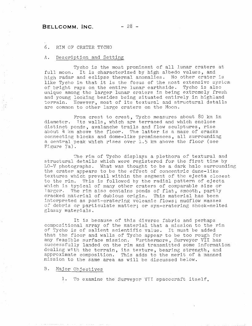
Tycho is the most prominent of all lunar craters atfull moon. It is characterized by high albedo values~ andhigh radar and eclipse thermal anomalies. No other crater islike Tycho in that it is the focus of the most extensive systemof bright rays on the entire lunar earthside. Tycho is alsounique among the larger lunar craters in being extremely freshand young looking besides being situated entirely in highlandterrain. However, most of its textural and structural detailsare common to other large craters on the Moon.
From crest to crest, Tycho measures about 80 km indiameter. Its walls, which are terraced and which enclosedistinct ponds, avalanche trails and flow sculptures, riseabout 4 km above the floor. The latter is a maze of cracksconnecting blocks and dome-like prominences, all surroundinga central peak which rises over 1.5 km above the floor (seeFigure 7a).
The rim of Tycho displays a plethora of textural andstructural details which were registered for the first time byLO-V photographs. What was thought to be a dark halo surroundingthe crater appears to be the effect of concentric dune-liketextures which prevail within the segment of the ejecta closestto the rim. This is followed by the radial pattern of ejectawhich is typical of many other craters of comparable size orlarger. The rim also contains ponds of flat, smooth, partlycracked material of dubious origin. This material has beeninterpreted as post-cratering volcanic flows; mudflow massesof debris or particulate matter; or syn-cratering shock-meltedglassy materials.
It is because of this diverse fabric and perhapscompositional array of the material that a mission to the rimof Tycho is of salient scientific value. It must be addedthat the floor and walls of Tycho appear to be too rough forany feasible surface mission. Furthermore, Surveyor VIr hassuccessfully landed on the rim and transmitted some informationdealing with the terrain, its texture, bearing strength, andapproximate composition. This adds to the merit of a mannedmission to the same area as will be discussed below.
B. Major Objectives
1. To examine the Surveyor VII spacecraft itself.
BELLCOMM, INC. - 29 -
2. To collect information and samples from the immediatevicinity of the spacecraft to further evaluate thetechnological efficiency and the scientific accuracyof the Surveyor-type instruments in future lunarand/or planetary missions.
3. To extend the area of exploration beyond what wastested by the Surveyor VII spacecraft. This wouldinclude such important features as: blocks of rockwhich were ejected from Tycho itself; the manyflow-like surface blankets on the rim; the dune-likeconcentric bands of hummocky material; ray materialsradial to Tycho; and at least one of the "poolsltwhich are commonly observed on the rim of Tycho aswell as craters of comparable or larger size.
4. Emplacement of a geophysical station in the southernhighlands.
C. Landing Area
As mentioned above, the mission to Tycho is proposedfor a 5 km mobility~type mission. However, it appears feasibleto achieve the aforementioned objectives without utilizingmobility aids. Figure 7b illustrates a one km radius circlewhich enclosEs most targets of salient scientific and technological interest on the rim of crater Tycho, where the numberswithin the circle correspond to the following:
1. Location of Surveyor VII spacecraft
2. A field of large blocks, which may have been derivedfrom within Tycho
3. An area where several flow blankets could be recognized,studied and sampled
4. Dune-shaped terraces of hummocky terrain similar tothat along the rim crest of the crater Tycho andpossible ray materials
5. A large pool (of post-cratering volcanic rocks; orsyn-cratering particulate or shock-melted material)which displays well developed shrinkage cracks aswell as small collapse, crater-like features.
From the above discussion, it is concluded that avery profitable "walking mission" could be planned to the rimof crater Tycho. Mobility aids do not seem essential at themoment, although the use of LFU's would enhance the value ofthe mission.
RIM OF CRATER TYCHO
COORD INATES:
41°4585 11030·W
LAC CHART: 112
TYCHO
ALBEDO: 00 155
lO-IV: H·119
LO-V: V-3D
fRAMES: 125-128
- 30 ~
FiGURE 7a
- 31 -
FIGURE 7be PROPOSED LAND ING SITE ON THE R1M OF CRATER TYCHO
8ELLCOMM, iNC.
7. CRATER COPERNICUS
- 32 -
A. Description and Setting
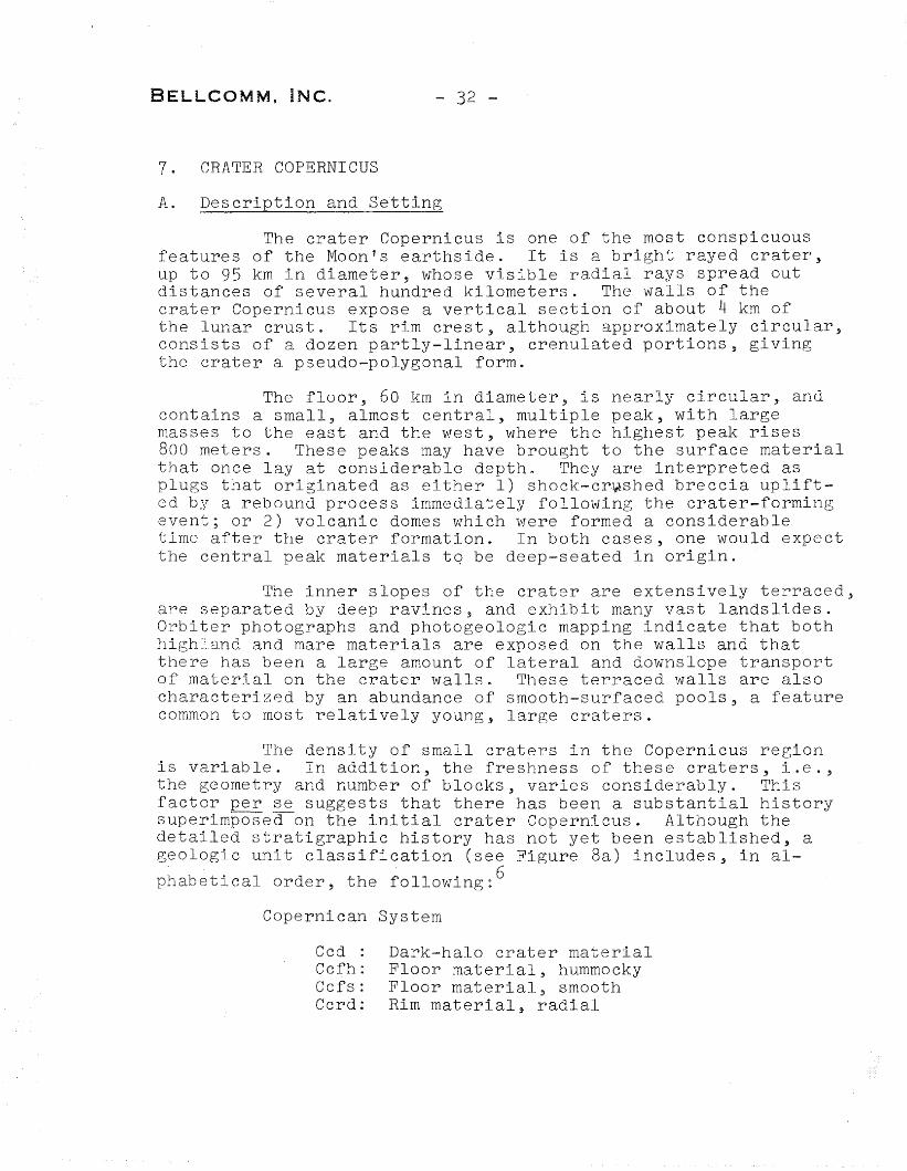
The crater Copernicus is one of the most conspicuousfeatures of the Moon's earthside. It is a bright rayed crater,up to 95 km in diameter, whose visible radial rays spread outdistances of several hundred kilometers. The walls of thecrater Copernicus expose a vertical section of about 4 km ofthe lunar crust. Its rim crest, although approximately circular,consists of a dozen partly-linear, crenulated portions, givingthe crater a pseudo-polygonal form.
The floor, 60 km in diameter, is nearly circular, andcontains a small, almost central, multiple peak, with largemasses to the east and the west, where the highest peak rises800 meters. These peaks may have brought to the surface materialthat once lay at considerable depth. They are interpreted asplugs that originated as either 1) shock-cr~shed breccia uplifted by a rebound process immediately following the crater-formingevent; or 2) volcanic domes which were formed a considerabletime after the crater formation. In both cases, one would expectthe central peak materials tq be deep-seated in origin.
The inner slopes of the crater are extensively terraced,are separated by deep ravines, and exhibit many vast landslides.Orbiter photographs and photogeologic mapping indicate that bothhighl.and and mare materials are exposed on the walls and thatthere has been a large amount of lateral and downslope transportof material on the crater walls. These terraced walls are alsocharacterized by an abundance of smooth-surfaced pools, a featurecommon to most relatively young, large craters.
The density of small craters in the Copernicus regionis variable. In addition, the freshness of these craters, i.e.,the geometry and number of blocks, varies considerably. Thisfactor per se suggests that there has been a substantial historysuperimposea-on the initial crater Copernicus. Although thedetailed stratigraphic history has not yet been established, ageologic unit classification (see Figure 8a) includes, in al-
Peak materialSlope material (freshly exposed bedrock and freshly generated talus).
1. To sample the floor material, the central peaks,the wall materials and the pools superposed onthem. The extent of compositional variations willgive clues as to the differentiation of the Moon.
2. The study of structural patterns of the centralmountains and the walls, where both have undergoneconsiderable mass wasting as shown by the apron ofdebris near the base of the peaks and the Ildeltas"of flow-like materials at the base of the walls.The middle of the three prominent central peaks alsodisplays a dark stripe running down its side. Thisstripe may be a tilted resistant bed or a dike ofdeep-seated origin. The structural interrelationships of these major features will shed light ontheir origin, and the origin of the crater itself.
3. Determination of cosmic ray exposure age of the largeblocks around the peaks, the layered wall materials,and the ejecta surrounding small craters on the floor.This will allow deductions concerning the time elementof the crater history based on actual measurements.
4. Observations of geophysical parameters at Copernicuswill not only extend the regional coverage but willprovide local data for the interpretation of thislarge crater. It will be valuable to examine thedifferences between craters in mare and those in thehighlands and to see whether or not they exhibitsubsurface differences. Local geophysical measurements, such as seismic and gravity profiles, shouldbe useful in elucidating the origin of the centralpeaks. Also, the question of whether large cratersare in isostatic balance could be examined on thebasis of data on the local gravitational field.
C. Landing Areas
The above mentioned objectives could be accomplishedbest by two missions to the crater Copernicus, one to thecentral peaks and the other to the walls; or by a dual missionthat wquld cover both. If two single missions were to beplanned, it is feasible, although restrictive, to achieve theobjectives without the use of mobility aids.
BELLCOMM. INC. - 34 -
A mission to the central peaks would be mainly asampling mission, with some emphasis on structural relationships.As illustrated in Figure 8b, it is possible to cover (withinless than 1 km from the designated landing point) the following:
1. Floor material exhibiting small low domes and avariety of craters
2. A field of blocks originating from the top of thepeak
3. A possible extension of the resistant bed (or dike)
4. A sharp contact between the floor and a small mound
A similar type of mission could be planned for theexploration of a portion of the crater wall and one of thenumerous pools on the wall terraces. An example is illustratedhere as Figure 8c where the numbers within the 1 km radiuscircle correspond to:
1. The cratered surface of a major pool
2. Contact between the pool, a large vertical sectionof the wall (where some bedding may be observed),and a field of blocks
3. A crater displaying a well-developed central mound,which may have been formed by a fallen rock from thewall
4. An irregular multi-ring crater which is geometricallysimilar to these formed in a thin fragmental layer.
5. A bright-halo crater situated on a mound which mayallow a good viewing area of the crater Copernicus.
Logistically, it may not be feasible to plan theabove mentioned missions to the crater Copernicus. However,in any case, both the central peak and the wall remain as theessential areas to be explored. The information to be gainedfrom both areas are complementary and the value of exploringonly one of the two is dubious. For this reason, a dualmission or any other type of mission to this crater must utilizethose mobility aids and enough stay time which would allowcovering both areas.
BELLCOMM, INC. - 35 -
As far as the central peaks area is concerned, theobjectives as well as the surface operations would not varymuch in a different type of mission. The one factor that mayenhance the value of this part of the mission would be the useof Lunar Flying Units which would allow the investigation of theupper parts of the peaks.
The part of the mission devoted to the study of thewall, however, may differ considerably, where only the basalparts of the wall would be available for surface exploration.An example is illustrated in Figure 8d where the numbers withinthe 5 km radius circle refer to the following:
1. Cracked floor material
2. Fronts of down-slope flow
3. A block of wall material (in situ/or slump block)
4. Mounds attaining circular dome configurations
5. Craters and other depressions
6. Small valleys produced by relatively large cracksand fractures.
One of the major lunar valleys is named after therenowned German selenographer J. H. Schroeter. It lies within the Aristarchus Plateau and forms a sinuous depression ofup to 1300 meters from the floor to the rim. Schroeter'sValley terminates on one end in what early selenographerswere inspired to call the Cobra Head, a large deep depressionwhich is interpreted as its sour~ From the Cobra Head alsosprings a smaller sinuous rille that meanders along the wholelength of the valley floor. This median rille is common toother, similar, valleys on the Moon's earthside, such asthose in the Harbinge~ Mnuntain Region and the Alpine Valley.In addition to this, it is characterized by its high thermalanomaly and the repeated occurrence of transient phenom-ena.
Lunar Orbiter photographs revealed significantdetails of the walls and floor of Schroeter's Valley, itsmedian sinuous rille and of the adjacent smooth dark deposits.Some of the latter appear to be of volcanic origin and youngerthan the Aristarchus secondary craters. The morphology ofthe numerous cones and domes, if they are indeed analogous toterrestrial examples, suggests that these rocks are intermediate in composition, i.e., more silicic than the materialof the mare.
The geologic interpretations of the various unitsin and around the valley (Figure 9a, lower right) include
the fOllowing: 7
Copernican System
Ccrd:Csc
Ch
Csv
Crater rim materialCopernican satellite craters (secondary impact craters)Cobra Head formation (Ejecta-flowblanket)Sinuous rille material
Ipm Mare material (Archimedian Series)If Fra Mauro Formation (Apenninean Series)
B. Major Objectives
1. Investigation and sampling of the varied rock typesin the vicinity of the valley, preferably close tothe Cobra Head.
2. Exploring the possibility of finding primordialvolatile substances (unmodified by an atmosphereor hydrosphere) which may have been connected withthe repeatedly observed transient color phenomena.
3. Study of the structural relationships between thevalley and its median rille to decipher their genesis.
4. Emplacement of a geophysical observatory stationin one of the suspected tectonically active areason the Moon's earthside.
C. Landing Area
As illustrated in Figure 9b, a desirable landingarea (A) lies northeast of the Cobra Head on the easternflanks of Schroeter's Valley. The terrain in this area israther rugged, but it is also rough all along the valley dueto the structural setting of the valley and its proximityto the crater Aristarchus. Landing in this area would allowthe achievement of all the major objectives listed above.Two alternative landing areas are marked Band C where themajor targets would be a gigantic landslide along the valley'swall, and a conspicuous cut-off channel of the median rille,respectively. However, in both cases, the Cobra Head, whichis a very important feature, would be inaccessibl-e-.--
42 -
SCHROETER 8S VALLEY
COORDINATES:
2So09 1N 49030~W
SELEUCUS - ARiSTARCHUS
ALBEDO: O. 103
LO- IV: H.... 150
38-39
202-205
V-49
FRAMES:
LAC CHARTS:
LO-V:
FI GURE 9a
FIG
URE
9b.
PRO
POSE
DLA
ND
ING
SITE
SFO
RSC
HRO
ETER
'SVA
LLEY
BELLCOMM, INC.
9. MARIUS HILLS
- 44 -
A. Description atid S~~~ing*
The Marius Hills is a group of domes and conesnear the center of Oceanus Procellarum, and west, northwestof the crater Marius, where isolated hills and clustersof hills rise above the mare surface and form part of a majornorth-south median ridge system that stretches irregularlysome 1900 km through Oceanus Procellarum. Many of the hillsexhibit the convex upward shapes suggestive of terrestriallaccolithic intrusions; and some resemble terrestrial shieldvolcanos. Generally, these hills are pocked with numerouslarge craters and are conspicuously rougher than the adjacentmare surface. Other hills have irregular outlines, low steepsides, and flat or slightly concave tops with a crater densitysimilar to the nearby mare surface. The variety of thesefeatures and their similarity to terrestrial volcanic structuresstrongly suggests that the area has been subjected to intensiveand prolonged volcanic activities.
The expression of the local median ridge is complex,consisting of a broad, prominent ridge system up to 10 km wide,bounded by sharp slopes at the margins. The generally convexupper surface of the ridge is locally broken by narrow ropeyridges and irregular linear depressions that deviate as muchas 30 degrees from the trend of the main ridge. Narrow ropeyridges subparallel to the main ridge locally interrupt the~urrounding mare s~rface.
Two sinuous rilles cross the main ridge from eastto west. The larger rille, more than one km wide near itscircular head, crosses the ridge approximately at right angles.The rille is V-shaped where it crosses the ridge, whereasits segments east and west of the ridge exhib~t a flat floor.Craters with diameters comparable to the rille's width havedeformed the rille near the east side and middle of the ridge,and ejecta from a 2-1/4 km crater at the western margin of theridge has partially filled the rille. The smaller sinuous rille(300-500 meters wide) has an elongated head and the rille makesan abnormally abrupt turn within the ridge. Younger cratershave modified this rille at the eastern margin, as well as west,of the ridge.
*Based on descriptions by J. F. McCauley of the U. S.Geological Survey.
8ELLCOMM, INC. - 45 -
As illustrated in Figure lOa the area is divided
into the following stratigraphic units: 8
Copernican System
Cs: Slope material; poorly sorted rockfragments
Eratosthenian System
Ecr: Crater rim material
Marius Group
Eml:Em2:Em3 :
B. Major Obj~~tives
Smooth undulating materialMaterial of low domesMaterial of steep domes
1. The position of Marius Hills in a probable volcanicprovince that straddles the median ridge of OceanusProcellarum provides an excellent opportunity tostudy materials, processes and structures associatedwith the formation of a major planetary ridge whichis comparable in extent to the mid-oceanic ridges onearth. These ridges may be surface expressions offundamental processes connected with the differentiation and/or convection in the planetary body.
2. As a volcanic province, the Marius Hills region alsoprovides an opportunity to sample a nearly continuoussequence of material which originated from within andwas then subjected for varying lengths of time tolunar and extra-lunar processes. The rock in the areashould provide data relating to: the nature of theprimitive lunar materials, the extent of magmaticdifferentiation on the Moon, time dependency of surfacealteration processes such as cratering or mass wasting,cosmic ray exposure times and solar wind fluxes, etc.
3. Geophysical investigation of the region to allow abasis for the three-dimensional interpretation of thelocal features, as well as for comparison with otherand similar physiographic provinces~
8ELLCOMM. INC. - 46 -
C. Landing Ar.ea
Due to the large areal extent of the Marius plateauplains, identical features may occur at several places in theregion. Hence, there are a great number of possible landingareas for manned surface exploration. The area shown in FigurelOb offers a good choice. The numbers within the 5 km radiuscircle refer to the following:
1. A rimless circular depression, which may be acollapse feature, in mare material of the Mariusplateau plains.
2. Smooth textured low domes which rise up to 100meters above the surrounding plains.
3. Rugged, pock-surface, steep-sided domes whichare generally llperched" upon the low domes.
4. Elongate, steep sided, relatively smooth conicalstructures with one or several linear depressions.
5. A steep-sided, relatively narrow and sharpwrinkle ridge in mare material of the plateauplains.
6. A partly sinuous, partly linear subdued trough.
These and many other features such as bulbousdomes, exposures of bedrock or blocks, bright halo craters,etc.~ are well defined in a preliminary large scale geologicmap of the area (Figure 10c) recently prepared by J. F.McCauley. The map also includes graphical delineations of apreliminary mission plan which is described at length in a
U. S. Geological Survey report. 9
- 47 -
....--------...fIII,------1IIJIl
MARIUS HILLS
COORDINATES:
13°45 BN 56000 1W
LAC CHART: 56
HEVELI US
ALBEDO: Oe 077
lO- IV: H-157
LO-V: V-51
FRAMES: 210-217
FIGURE lOa
48
UJi--
(/)
~
zoZ<C....J
oLJ.J(/')
oC-O~a..
u...
FIGURE IOc.
- 49 -
EXPLANATI ON
CRATER UNITS
[§] BRIGHT HALO CRATER
II] CRATER MATERIALS
~ PARTIALLY BURIED CRATER
MARlUS GROUP
[il PUNCTURED CONES
~ BULBOUS DOMES
~ STEEP SIDED DOMES
lliJ LOW DOMES
~ PLATEAU PLAI NS
·mlJ NARROW RIDGE
STRUCTURES
~ BEDROCK OR BLOCKS
CONTACT
+- SUBDUED TROUGH
MISSION PLAN
• ELM LANDING POINT
LRV TRAVERSES
EXTENDED lRV TRAVERSES
LFU TRAVERSES
* EXPLOSiVE CHARGES
<I' 3 GEOPHONES FOR ASE
I#M 8 GEOPHONES FOR ASE
® DEPLOY AlSEP
®B ALTERNATE LAND ING AREA
! COMMUNI CATOR REPEATER
62 TRAVERSE STATIONS
...rr-'rH)XIMATE SCALE I 25,000
2
GEOLOGIC MAP OF THE MARIUS HILLS AREA (FIGURE lOb)(AFTER J. F. McCAULEY, 1968)
BELLCOMM, INC. - 50 -
III. THE PLAN IN PERSPECTIVE
A. Summary of the Characteristics
The nine sites proposed by the Group for Lunar Exploration Planning (GLEP), for manned exploration of the Moon'searthside, constitute a well-balanced selection of scientificallyimportant areas. This is demonstrated in Table I which liststhe geologic characteristics of the individual sites and showsa histogram of the textural and structural features of the areasto be explored at these sites.
It is clear, from Table I, that there is emphasis oncertain features (for example, single, circular craters inmare), but this is largely due to the relative abundance of thefeatures themselves. The apparent lack of representation ofsome features (such as domes in highlands and ghost craters) isdue to their localization so far away from other importantfeatures such that: 1) they could not be reached in anyone ofthe proposed missions, and 2) they are not so important themselves to be considered, alone, for a manned exploration mission.
Prior to reviewing -t h e exploration plan in toto, weshall summarize the salient features of the nine siteS:--
1. Crater Censorinus: A small, fresh (impact) craterin highland terrain, at the rim of a large mare basin.
2. Littrow Area: Very dark (volcanic) blanket materialwhich mantles both Serenitatis Bench rocks and avery fresh mare ridge.
3. Abulfeda (Crater Chain): Possible deep-seated materialin and around a (volcanic) crater chain, and theassociated ll c i n de r cones", in the Southern Highlands.
4. Hyginus Crater and Rille: The floor of crater Hyginus,the walls of the linear rille and the surroundingplains (Cayley Formation).
5. Apennines - Rima Hadley: The Apennine mountain front,its contact with the mare and relationship to a youngsinuous rille.
BELLCOMM, INC. - 51 -
6. Rim of Crater Tycho: Composition, textures andstructures of part of the rim of a large rayed craterin highland terrain.
7. Crater Copernicus: Potential deep-seated rocks atthe central peaks and the flow and mass wastingstructures along the walls.
8. Schroeter's Valley: A large lunar valley, its mediansinuous rille, and their genetic relationships to the"Cobra Head".
9. Martus Hills: A complex of (volcanic) domes, cones,mare ridges and sinuous rilles in Oceanus Procellarum.
As previously stated in the introduction, it isassumed that manned missions to these nine sites would followthree missions to less complex areas on mare surface and relatively smoother terrains. These would include one mission to aneastern mare, a western mare and an old terrain, preferably theFra Mauro Formation.
B. Mobility Requirements
No mobility aids are envisioned for the first threeApollo missions to the mare and other relatively smooth terrains.Furthermore, the nine sites described in this report were selected with the assumption that three of them (Censorinus, Littrowand Abulfeda) would also be "walking missions", i.e., no mobilityaids. For the remaining six missions, some form of mobility isrequired beyond the walking range of the astronauts, whose limitis presently set at 1.5 km. The means of mobility under consideration include:
1. Lunar Flying Unit (LFU)
2. Lunar Roving Vehicle (LRV) and/or Field Assistant (FA)
3. Unmanned Lunar Roving Vehicle (ULRV)*
The minimum radius-of-operations of all manned mobility aids is set tentatively at 5 km, and that of the ULRV isthought of as being about 500 km. The concept of the latter has
*Vehicles 2 and 3 may be combined in a dual mode vehicle
BELLCOMM. INC. - 52 -
not been fully developed yet, and, therefore, will not beconsidered here (see example given in Figure 6c). The useof manned mobility aids is naturally site-dependent. Aflying vehicle would be preferred if one's aim is to reacha feature which is several kilometers away, and if the traverse is to cross great differences in elevation. The rovingvehicle would be preferred if it is important to make severalstops along a traverse, especially if the terrain is relatively flat, and when there is need to conduct extensive geophysicaltraverses.
With the aforementioned considerations in mind, itseems that the LFU is preferred in many more sites than the LRV.Table II is a listing of mobility aid preferences in the nine(GLEP) sites. The choice of ODe type of vehicle as a mobilityaid for a given site is based mainly on the geologic characterof the area to be explored. It represents the author's ownviewpoint and further investigations are necessary, especiallyof geophysical requirements, before the final selection ofmobility aids for each of the sites.
C. Expected Achievements
Considering our limited knowledge of the lunar surface,it is a difficult task to visualize the extent and the value ofall scientific and technological accomplishments of lunar surfaceexploration. A modest attempt is made here to demark some ofthe more obvious expectations.
Naturally, the exploration plan in question does notinclude alI features of scientific interest, but it representsa well balanced selection of them. The plan could be dividedinto four phases (see Table III); each phase includes a groupof three sites with some common characteristics. Following arebrief descriptions of these phases:
Phase I includes two landing sites in mare regions(one red and one blue) as well as one site in an old formationsuch as the Fra Mauro Formation or the Cayley Formation, preferablythe former. Common to all three are the following:
1. Location in the Apollo Zone
2. Relative smoothness of the surface to be explored
3. Accessibility of features within walking range (1.5 km)
4. A limited stay time of less than 36 hours.
BELLCOMM, INC. - 53 -
Phase II embraces two (impact) craters of differentsizes, Censorinus (3.5 km) and Tycho (80 km) where one expectsto sample deep-seated hummocky ejecta. It also includes the'Littrow area where some of the darkest, and probably youngest,(volcanic) mantling material on the lunar surface occurs.Among the parameters common to these three sites are:
1. Non-free return and a limited stay time (about 36 hours)
2. Abundance of blocks and/or in situ bedrock
3. Accessibility of features within walking range (1.5 km)
4. Possibility of establishment of a seismic net.
Phase III includes three sites where tectonism andvolcanism are thought to be responsible for the features inquestion. We expect to encounter endogenous, deep-seated lunarmaterials at both the Hyginus and Abulfeda sites and to examinethe physical expressions of transient phenomena at Schroeter'sValley. Common to these three sites are the following:
1. Non-free return and a stay time of about 3 days
2. Need of mobility aids (LFU's) in surface exploration.
Phase IV includes three sites (crater Copernicus,Apennines-Rima Hadley and Marius Hills) which entail a much moreelaborate means of exploration. Their study relates to majorquestions concerning the Moon mainly because of the anticipatedencounter of large stratigraphic sections, both vertical andhorizontal. In themselves, they are among the most importantsites, and among the parameters common to them are:
1. A stay time of more than 3 days
2. Expected unmanned payload delivery and surface rendezvous
3. Need of mobility aids (LFU and/or LRV)
Table IV illustrates some of the expected scientificand technological accomplishments of the four phases of the plan.The three examples of scientific fields (geology, geochemistryand geophysics) are not the only ones to be considered, andmuch the same could be said for other fields of endeavour. Thedashed blocks in Table IV correspond to the four phases and theirexpected achievements in a given field. It is clear from thetable that the knowledge to be gained from one phase of the planis fundamental to the success of the following phase.
BELLCOMM. INC.
D. Conclusions
- 54 -
The proposed exploration plan, which includes the 12sites listed in Table III, constitutes a well-balanced selectionof scientifically important areas on the Moon's earthside.From the scientific point-of-view, results of the program wouldyield significant data on:
1. The chemical heterogeneity of lunar surface rocksand the differentiation of the Moon as a whole
2. The differentiation of lunar magmas and the surfacemanifestations of endogenic tectonism and volcanism
3. Extra-lunar processes, impact bodies, cratering eventsand their modifications to the surface
4. Geophysical processes such as isostasy, magnetism,seismicity, and Earth-Moon interaction
5. The geochemical (organic and inorganic) historyof the lunar surface and its environment.
20l5-FEB-kse
zp
~
_L-_
~g'"
,.OJ:,.g co~
-o25~
g OJ:
~-cco
~ i3~zz~
s: co8
0;;i,. ~
~zco
'"OJ:coco
~~
'>rv~ 0
'"co;;;'" vi-c
~'"gr;iii~co~
<'"~~z
o-z~
GO
~2i
~zr;;coo-
""~::; co
-<~OJ:OJ:
'"co
~ 0
~~OJ:,.
<z
LIGHTLIGHT; DARKDARK0s:~;;;
SMOOTHcoso
ROUGHI'"
»cROUGH,.n
EVEN"
EVEN--~IOJ: co;;
PITTEDPITTED'"OJ::;;:;
RUGGEDg,6
--.~t-r-f-~
SINGLE
~,."(")
PAIRi"PAIRITlc:~:l>3:
CLUSTER~:-iC:::c::..
CHAINxxCHAINAI> 1Tl--lCIRCULARxxxxxxxCIRCULAR
(I)-x<: ---coorri ELONGATExxELONGATE
~.. o·."
POLYGO:'AL~:G)
-I:::0::11:> IRREGULARrn..,.,
:r.INMARE~>-
;;i;::00INHIGHLANDcoJTI."
'",.>- ~
-1BRIGHTOJ:~en-i ,.:::a:::
DARKIIIIxIIDARK::;-IITI0-l
STEPPED(")::> com::t:3'm
EJECTArri»• ;::0ITIPEAK~rri» -«><(") co
-0-i RIDGEcoco~
..ITI co0;::0
HUMMOCKS;:lCI-
fRESHITIenO-i
,.-~i-+H++~
xfiLLED~-(")zen
GHOST,IGHOST-1>-
BEDDING:::a:::ZITl0
xl><lxlIxIICONTACT~
~co:z:en .>
--i EROSION
"ZAI
DEPOSITIONITIc::(")
~++-m-++S_CARPen--I-c:::
SLUMPxxSLUMP
~I-i;::0ITl>- ---en. DISPLACE.
--LINEAR---SINUOUS'"
~
~
'" INM~RE~coco~co
INHIGHlANDco
'" BRIGHT~so
DARK'"
~
INMARE~
INHIGHLAND
fLOW'"'"
WRINKLEa~INMARE'"0
INHIGHLAND~,.
COLORCOLORe:0s:
THERMALxTHERMAL/?-c
££
- 56 -
TABLE IIPREFERENCE OF MOBILITY AIDS FOR THE NINE (GLEP) SlTES
TYPE OF MOBILITYNOG SITE DES~GNATION
NONE LFU LRV
I CRATER CENSORINUS X
2 LITTROW AREA X (?)
3 ABULFEDA (CRATER CHAIN) (1) X
4- HYGINUS CRATER &RILLE X (1)
5 APENNINES-RIMA HADLEY X (?)
6 RIM OF CRATER TYCHO X (1)
7 CRATER COPERNICUS X (1)
8 SCHROETER'S VALLEY X
9 MARIUS HilLS X X
- 57 -
TABLE II J
PHASES OF THE LUNAR EXPLORATION PLAN
{EASTERN MARE
PHASE I WESTERN MARE
FRA MAURO FORMATION
{CRATER CENSORINUS
PHASE II LITTROW AREA
RiM OF CRATER TYCHO
{ HYGINUS CRATER &RILLE
PHASE III . ABULFEDA (CRATER CHAIN)
SCHROETER'S VALLEY
{CRATER COPERNICUS
PHASE IV APENNINES-RIMA HADLEY
MARIUS HILLS
TABL
EIV
EXPE
CTED
SCIE
NTIF
ICAN
DTE
CHNO
LOGI
CAL
ACCO
MPL
ISHM
ENTS
OFTH
ELU
NAR
EXPL
ORAT
ION
PLAN
TO
TA
LST
AY
TIM
E
LUN
AR
LA
ND
ING
MIS
SIO
NN
UM
BER
xn CO
GE
OC
HE
MIS
TRY
ELEM
ENT
DIS
TRIB
UTI
ON
CO
SMIC
RAY
EXPO
SUR
E
ION
OSP
HE
RE
,N
EU
T.
PAR
T.
HEA
TFL
OW
(HFE
)
SUR
.ST
RU
CTU
RE
(ASE
)
CH
AR
GE
DPA
RT.
(CPL
EE)
SOLA
RW
IND
CO
MPO
SIT
ION
SOL
AR
WIN
D(S
WS)
MA
GN
ET
ICFI
ELD
(LSM
)_
.------
---------
SEIS
MIC
ITY
(PSE
)
__
_t-
AG
ED
AT
ING----I
RA
DIO
AC
TIV
ITY
RILL
ES
MA
NN
ED
OPE
RA
TIO
N
UN
MA
NN
ED
DEL
IVER
Y
LUN
AR
FLY
ING
UN
IT
TYPE
OF
LA
ND
ING
AN
DE
XPL
OR
AT
ION
SCIE
NC
EST
AT
ION
LUN
AR
RO
VIN
GV
EHIC
LE
SUR
FAC
ER
EN
DE
ZV
OU
S
1N
ON
-FR
EE
RET
UR
N
iSIN
GL
ESI
TESU
RV
EY
!RED
ESI
GN
AT
ION
~~._-,-----
iA
LSEP
DEP
LOY
MEN
T
SAM
PLE
AN
ALY
SES
}---_
._------+
MA
RER
OC
KTY
PES
----
-------~-.-----1
-- C
RU
STA
LC
OM
POSI
TIO
N:'->.>.''',t--------+--~---
HIG
HL
AN
DC
OM
POSI
TIO
N---J-------
---_
.M
AG
MA
DIF
FER
EN
TIA
TIO
N-----
-----
CH
EM
ICA
LH
OM
OG
EN
IET
Y
GE
OC
HE
MIC
AL
HIS
TOR
Y
GE
OL
OG
Y
TEC
HN
OLO
GY
BELLCOMM. INC.
REFERENCES
- 59 -
1. Unpublished geologic map of the Region of the Moon byDonald P. Elston (1965), u.S. Geological Survey.
2. Geologic map of the Mare Serenitatis Region of the Moon byM. H. Carr (1966), U.S. Geological Survey, Map 1-489(LAC-42).
3. Unpublished preliminary geologic map of the TheophilusRegion of the Moon; Map by D. J. Milton is in preparation(1968), U.S. Geological Survey.
4. Unpublished preliminary geologic map of the Mare VaporumRegion of the Moon; Map by D. E. Wilhelms is in preparation (1968), u.S. Geological Survey.
5. Geologic map of the Montes Apenninus Region of the Moonby R. H. Hackman (1966), U.S. Geological Survey, Map 1-463(LAC-41).
6. Geologic map of the Copernicus Region of the Moon byH. H. Schmitt, N. J. Trask and E. M. Shoemaker (1967),U.s. Geological Survey, Map 1-515 (LAC-58).
7. Geologic map of the Aristarchus Region of the Moon byH. J. Moore (1965), U.S. Geological Survey, Map 1-465(LAC-39).
8. Geologic map of the Hevelius Region of the Moon byJ. F. McCauly (1967), U.S. Geological Survey, Map 1-491(LAC-56).
9. Preliminary Lunar Exploration Plan of the Marius HillsRegion of the Moon, by T. N. V. Karlstrom, J. R. McCaulyand G. A. Swann (1968), U.S. Geological Survey.
- 60 -
APPENDIX A
Members of the Site Selection Subgroup of the Group for LunarExploration Planning who participated in the Site Selection
Meeting of December 8-9, 1967
John Adams
Donald A. Beattie
John Dietrich
Farouk EI-Baz
Paul Gast
Wilmot N. Hess
Noel W. Hinners
Charles Lundquist
Harold Masursky
Harrison H. Schmitt
Eugene Simmons
Donald E. Wilhelms
Jet Propulsion Laboratory
NASA Headquarters
Manned Spacecraft Center
Bellcomm, Incorporated
Lamont Geological Observatory
Manned Spacecraft Center
Bellcomrn, Incorporated
Smithsonian Astrophysical Observatory
U.S. Geological Survey
Manned Spacecraft Center
Massachusetts Institute of Technology
U.S. Geological Survey
- 61 -
APPENDIX B
STRATIGRAPHY OF THE LUNAR SURFACE*
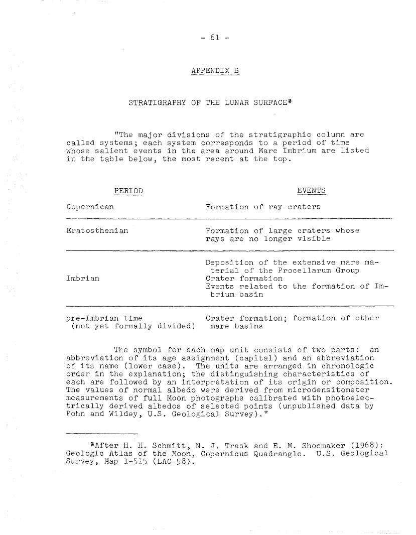
"The major divisions of the stratigraphic column arecalled systems; each system corresponds to a period of timewhose salient events in the area around Mare Imbrium are listedin the table below, the most recent at the top.
PERIOD
Copernican
Eratosthenian
Imbrian
pre-Imbrian time(not yet formally divided)
EVENTS
Formation of ray craters
Formation of large craters whoserays are no longer visible
Deposition of the extensive mare material of the Procellarum Group
Crater formationEvents related to the formation of Im
brium basin
Crater formation; formation of othermare basins
The symbol for each map unit consists of two parts: anabbreviation of its age assignment (capital) and an abbreviationof its name (lower case). The units are arranged in chronologieorder in the explanation; the distinguishing characteristics ofeach are followed by an interpretation of its origin or composition.The values of normal albedo were derived from microdensitometermeasurements of full Moon photographs calibrated with photoelectrically derived albedos of selected points (unpublished data byPohn and Wildey, U.S. Geological Survey)."
*After H. H. Sohmitt, N. J. Trask and E. M. Shoemaker (1968):Geologic Atlas of the Moon, Copernicus Quadrangle. U.S. GeologicalSurvey, Map 1-515 (LAC-58).
ACKNOWLEDGMENT
The author is indebted to Dr. N. W. Hinners for
critically reading the material of the report and for offering
valuable suggestions for its organization.
BELLCOMM. INC.
DISTRIBUTION LIST
TR-68-34o-l
NASA Headquarters
Messrs. R. J. Allenby/MALD. A. Beattie/MALR. P. Bryson/SLE. M. Davin/MALL. E. Day/MATJ. M. Goldberg/MALR. J. Green/MALG. H. Hage/MAJ. B. Hanley/MALJ. K. Holcomb/MAOR. W. Johnson/MTLT. A. Keegan/MA-2D. R. Lord/MTDB. Milwitzky/SLM. W. Molloy/MALW. T. OiBryant/MALL. Reiffel/MA-6L. R. Scherer/MALJ. B. Skaggs/MAPA. T. Strickland/MALJ. H. Turnock/MA-4G. C. White, Jr./MARV. R. Wilmarth/MAL
NASA Hqs. Library - USS-IO (2)
Ames Research Center
Messrs. D. E. Gault/SSPW. L. Quaide/SSPL. Roberts/M
Goddard Space Flight Center
Dr. P. D. Lowman, Jr./644
Manned Spacecraft Center
Messrs. P. R. Bell/THA.. J. Calio/TAJ. w. Dietrich/TH2T. H. Foss/TH2J. W. Harris/TAJ. D. Hodge/FCW. N. Hess/TAE. A. King/TH2D. S. McKay/TH2
Manned Spacecraft Center
Messrs. A. J. Meyer, Jr./ETJ. H. Sasser/TH3H. H. Schmitt/CBJ. R. Sevier/PDl2J. W. Small/TD
Jet Propulsion Laboratory
Messrs. J. B. Adams/183-501J. D. Burke/lll-lIOL. D. Jaffe/169-335A. R. Hibbs/180-301
University of Arizona
Messrs. D. P. ElstonE. M. Whitaker
Southwest Center for AdvancedStudies
Dr. F. Johnson
University of California
Messrs. J. Arnold/San DiegoA. L. Burlingame/Berkeley
University of Virginia
Dr. L. W. Fredrick
Stanford University
Dr. R. Jahns
Mass. Institute of Technology
Drs. F. PressE. Simmons
BELLCOMM, INC.
DISTRIBUTION LIST
TR-68-340-1
Franklin and Marshall College
Dr. D. Wise
Lamont Geological Observatory
Dr. P. Gast
Smithsonian AstrophysicalObservatory
Dr. C. Lundquist
U.S. Geological Survey/Flagstaff
Messrs. A. H. ChidesterT. N. V. KarlstromJ. F. McCauleyH. PohnL. C. RowanE. M. ShoemakerG. A. Swann
U.s. Geological Survey/Menlo Park
Messrs. M. H. CarrH. MasurskyD. E. Wilhelms
Bellcomm, Inc.
Messrs. F. G. AllenG. M. AndersonD. R. AnselmoA. P. Boysen, Jr.D. A. ChisholmJ. P. DownsJ. GillepsieD. R. HagnerP. L. HavensteinF. HeapJ. J. HibbertN. W. HinnersB. T. HowardD. B. JamesJ. KrantonK. E. MartersteckR. K. McFarlandJ. Z. MenardV. S. MummertG. T. OrrokJ. W. PowersT. L. PowersI. M. RossP. S. SchaenmanR. L. SeldenJ. W. TimkoJ. M. TschirgiR. L. WagnerJ. E. Waldo
All Members Department 2015Division 101 SupervisionDivision 102 SupervisionDivision 201 SupervisionDepartment l023~'~~~Mm»