20
Bells Line of Road Corridor study SUMMARY NOVEMBER 2005

Bells Line of RoadCorridor study
SUMMARY
NOVEMBER 2005

Foreword
The NSW and Australian governments have committed funding to investigate the feasibility of upgrading the Bells Line of Road to become a major freight routebetween Lithgow and north-western Sydney.
The existing crossings of the Blue Mountains include the Great Western
Highway (primary route), Bells Line of Road (secondary route) and the Main
Western Rail Line.All have major limitations to their use as significant transport
corridors across the Blue Mountains.
The two road options are limited by very steep grades, tight curves and limited
overtaking opportunities. Rail use is also constrained by freight and passenger
rail having to share the same track.This, along with the steep grades, tight track
curvature and limited opportunities for commuter trains to overtake freight
trains, constrains rail in substantially increasing the amount of freight it is able to
transport across the Blue Mountains.
The Bells Line of Road Corridor Study concluded that:
The Main Western Rail Line over the Blue Mountains could be upgraded but
any upgrade would be unlikely to deliver significant benefits without major
upgrades east of Penrith and west of Lithgow.
All of the road upgrade options examined are feasible from an engineering
perspective.
None of the four-lane, B-Double road upgrade options examined appear feasible
from an economic or financial perspective for a range of growth assumptions.
All of the four-lane B-Double capable upgrade options would require the
full regional and economic development growth potential of the Central
West region to be realised over the next 30 years for the project to
progress towards being justified economically.
It is highly unlikely that private investment would be forthcoming to progress
this project without significant government funding.
All of the four-lane, B-Double road upgrade options, including the preferred
option would have significant environmental and social impacts.
Reserving a road corridor to enable future upgrade works along the Bells
Line of Road is complex and is likely to result in the need for detailed and
comprehensive environmental assessment and approval from the
Commonwealth and State governments. It is also likely to require funding
for property acquisition of approximately $230 million in 2004 dollars.
This Summary provides an overview of the Bells Line of Road Corridor Study.
INTRODUCTION 03
STRATEGIC CONTEXT 04
OPTIONS CONSIDERED 07
KEY CONSTRAINTS 09
SELECTION OF THE PREFERRED OPTION 13
NEED AND JUSTIFICATION 15
Contents
ADDENDUM: A typographical error was corrected in June
2008 in the table at the bottom of page 12. The dollar
value estimates for the Eastern to Richmond Road and
Western precincts had been inadvertently transposed.
NOTE: This version of the summary has been amended
to incorporate changes to the Environmental Planning &
Assessment Act 1979 that became active in August 2005.

Bells Line of Road corridor study Summary 3
Sydney
Newcastle
Wollongong
GoulburnYass
Denman
Dubbo
Parkes
Cowra
Bathurst
Lithgow
West Wyalong
Young
Cootamundra
Orange
0 25
Kilometres
50
LEGEND
B-Double Route
After a number of strategic studies during the 1990s,
the NSW Government committed $360 million to the
upgrade of the Great Western Highway and the Mitchell
Highway between Penrith and Orange over a 12-year period.
The Australian Government also contributed $100 million to
enable works in the Blue Mountains to be accelerated.These
works are expected to result in significant improvements to
the primary Blue Mountains crossing.
Some stakeholders in NSW’s Central West are of the opinion
that the lack of an efficient freight route across the Blue
Mountains is constraining regional growth. They are also
concerned that there is B-Double vehicle access to the Sydney
area from the north and south but not from the west.They are
of the view that this represents inequitable access to regional
markets and a major constraint to growth.
Introduction
The NSW and Australian governments have committed funding to investigate the feasibility of upgrading the Bells Line of Road, between Lithgow and north-western Sydney, to B-Double (greater than 19m long) standard.The NSW Roads and Traffic Authority (RTA), in partnership withthe Federal Department of Transport and Regional Services (DOTARS), is managing the study.
B-Double (greater than 19m long) approved routes
As a result, the RTA has engaged Sinclair Knight Merz to
undertake a Corridor Study to:
Review existing options to provide a link
between Lithgow and the Westlink M7
(formerly known as the Western Sydney Orbital).
Identify the option that best meets the needs
of heavy vehicle access between Sydney and
the Central West of NSW.
Assess the feasibility of a high standard road
across the Blue Mountains along the Bells Line
of Road corridor.
Develop a concept design for the best of
the four-lane options, to meet B-Double
standards.
N

Bells Line of Road corridor study Summary
HISTORY OF THE ROUTE
Bells Line of Road is rich in history reaching back to the early
days of British settlement of the then young colony of New
South Wales. At that time, the Blue Mountains constituted a
visible and real boundary to the pioneers who were confined
to the relatively narrow coastal plain.
A route to the south of the Grose River, clinging to the ridges,
was finally established with the aid of Aboriginal people in
1813.The current alignment of the Great Western Highway
essentially follows this route.A separate route to the north of
the Grose River did not reach the Bathurst Plains until 1823
when Archibald Bell (Junior) established its viability in a series
of three journeys in that year.
Despite some initial enthusiasm for Bell's more direct route,
the Great Western Highway remained the dominant route.
As a result very little public money was expended on
improving the dangerous pinches on the Bells Line of Road,
which remained primarily a stock route until well into the
twentieth century.
EXISTING ROLE
Bells Line of Road provides a secondary crossing of the Blue
Mountains supporting the Great Western Highway.This role
is clear when looking at the comparison of the daily traffic
volumes in the diagram opposite on p5.
In addition to its supplementary role
Bells Line of Road also provides:
Access to properties along the route.
Local access for Bilpin and Kurrajong areas.
Recreation and tourism access.
Firebreak and emergency access.
EXISTING CONDITION
Adjacent land uses
The major land uses in the vicinity of Bells Line of Road
are conservation and recreation, and rural production.
In terms of land use, the study area can essentially be divided
into four sections:
The eastern section, east of the Blue Mountains
escarpment at Kurrajong Heights, which includes the
Cumberland Plain, was a mix of urban and village areas,
urban fringe areas and rural production, and scattered,
generally isolated conservation areas.
The mid-eastern section, from Kurrajong Heights to
Mt Tomah, which includes generally rural uses following
the ridgeline adjacent to the road.
The mid-western section, which includes predominantly
conservation related land uses within National Parks,
World Heritage Areas and Wilderness Areas between
Mt Tomah and Newnes Junction.
The western section, between Newnes Junction and
Lithgow, which includes a mix of forestry and open
grazing land, resource mining and the city of Lithgow.
Strategic context
Bells Line of Road has been investigated as a freight route across the Blue Mountains since the earliest days of European settlement.With the competing local and through-traffic demands along the Great Western Highway some stakeholders in NSW’s Central West have been promoting an upgraded Bells Line of Road as a strategic regional development link between that region and the Sydney metropolitan area.
4
St Davids Anglican church on Bells Line of Road at Kurrajong Heights.

Bells Line of Road corridor study Summary5
The listing of the Blue Mountains World Heritage Area, the
identification of Bilpin as an ecological gateway and the high
biodiversity value adjacent to much of the route limit the
range of land uses able to be pursued and also place
constraints on existing land uses.
Traffic flows
As can be seen in the diagram on the right, traffic volumes
vary significantly along the route. Traffic flows increase
significantly at either end of the route with approximately
8,000 vehicles per day (vpd) in the west (influenced by
Lithgow) and approximately 12,000 vpd in the east (influenced
by Richmond). This compares with about 3,000 vpd in the
central area.
Weekend traffic along Bells Line of Road is approximately 60%
higher than weekday traffic indicating its tourist value.
Traffic volumes have remained similar since the mid 1970s for
much of the route.The exception to this is the eastern section
where Sydney’s growth to the west and north-west has seen
a steady increase in traffic using Bells Line of Road.
Travel times
Travel over the Blue Mountains along the existing Bells Line of
Road is generally faster, from end to end (as seen in the table
below), than the slightly longer journey via the Great Western
Highway.
Travel speeds are lower on weekends when weekend tourist
traffic increases. The sections of Bells Line of Road around
Bellbird Hill and Mt Tomah that are steep and winding slow
travels speeds significantly in these areas.The travel speed in
the vicinity of North Richmond is also slow due to intersection
performance and additional traffic.
Road safety
Bells Line of Road has a high accident rate, particularly in
the areas around Lithgow and towards Kurrajong, where
features of the existing road have contributed to accidents
in a number of cases.The accident rate is higher on Bells
Line of Road than the State average and higher than the
Great Western Highway.
Over 120 serious injury accidents occur each year on
Bells Line of Road. Investigation of the accident data
indicated that:
There were 564 accidents recorded between 1994-1998
and 545 between 1998-2002 indicating that the accident
rate has remained fairly constant, but nevertheless
is too high.
In more remote areas along the route most accidents
involved vehicles leaving the road.
The highest proportion of accidents involving heavy-goods
vehicles was between Kurrajong Heights and Newnes
Junction, many of these were vehicles leaving the road
and steep grades were attributable in a number of cases.
Eleven of the 13 fatal accidents recorded occurred
between Kurrajong Heights and Newnes Junction.
8000
3000
Bells Line Road
SECTION 1
Lithgow
Katoomba Glenbrook
RichmondSECTION 2SECTION 3
12,000
34,00022,000
14,000
Existing traffic volumes of Blue Mountains crossings
AVERAGE TRAVEL TIMES BETWEEN LITHGOW AND THE M7
ROUTE DISTANCE (KM FROM LITHGOW TO M7) AVERAGE TRAVEL TIME (TO NEAREST 5 MINUTES)
WESTBOUND EASTBOUND
TRUCKS CARS TRUCKS CARS
BELLS LINE OF ROAD 81 90 65 85 70
GREAT WESTERN HIGHWAY 89 100 85 95 85
Bells Line of Road corridor study Summary6
Travel patterns
The results from a truck origin /destination survey for both
Bells Line of Road and the Great Western Highway are
described below.The predominant trip end region is Western
NSW, which accounts for the majority of origins and
destinations for westbound trips.The main points to note from
the survey are that:
Bathurst, Orange and Oberon account for almost 80%
of origins and destinations in that region.
Orange produces a significant amount of manufactured
goods and receives a large amount petroleum to support
these industries.
Bathurst attracts a high proportion of building material
freight to the region due to its continuing residential
growth.
Approximately 50% of eastbound truck traffic travelling
to Sydney is destined east of the Westlink M7.
Almost all building materials and consumables are carried
on the Great Western Highway. One-third of trucks on
Bells Line of Road travel empty.The route also carries a
significant amount of farming and forestry cargo.
The typical journey length is between three and five hours
which corresponds to the approximate time taken for the
journey between Sydney and Lithgow/Bathurst.
Road design
Due to the mountainous terrain, the road has a high degree
of curvature resulting in at least 35% of the 81km from
Richmond to Lithgow is subject to advisory speeds of less than
100km/hr.
Steep gradients are common. Six percent of the route has
grades in excess of 10% (13% maximum) and 34% has grades
between 4% and 10%.With most fully-laden trucks travelling
at speeds of less than 50km/hr when sustained uphill grades
exceed 4% to 6%, Bells Line of Road, in its current condition,
would not be suitable as a designated truck route and would
not be able to cater for B-Double vehicles.
A further limitation to B-Doubles using Bells Line of Road is
that the tight curves result in the swept path of long vehicles
exceeding existing lane widths.This means that long vehicles
are sometimes forced to cross the centreline or have wheels
running outside the edge of the pavement which are both
unsatisfactory from a road safety perspective.
OTHER INVESTIGATIONS
A number of strategic studies and policies have been
developed that are relevant to this investigation.These include:
Central West Transport Study, 1996 by SMEC on behalf of
Central Regional Organisation of Councils (CENTROC),
the former NSW Department of Transport, the RTA and
other State agencies.
NSW Regional Study (The Central West),
1997 by NRMA.
Action for Transport 2010, 1998
by the NSW Government.
Penrith to Orange Transport Corridor Study,
1998 by Sinclair Knight Merz on behalf of the RTA.
The Regional Economics Research Unit Study (RERU),
1999 by Charles Sturt University on behalf of CENTROC.
The Bells Line of Road Development Study, 2000 by
Maunsell McIntyre on behalf of the RTA.
The Great Western Highway was the focus of the first four
studies while Bells Line of Road was the focus of the last two.
The Charles Sturt University study identified a number of
economic and regional benefits of upgrading Bells Line of Road
to a four-lane motorway standard. However, the study also
noted that the costs were likely to outweigh the proposed
benefits.
The study by Maunsell McIntyre concluded that:
Medium to long-term traffic demand across the Blue
Mountains justified the development of only one primary
route and a supplementary route.
The Great Western Highway is already the more
developed route and is designated as part of the
Australian Government’s AusLink National Network.
Bells Line of Road would be very expensive to
develop to a significantly higher standard because
of the severe terrain.
Continued investment in the Great Western Highway
should remain the priority, with periodic but limited
improvements to Bells Line of Road as the
supplementary route.

Bells Line of Road corridor study Summary 7
RAIL
No major rail improvements are currently planned for
the Main Western Rail Line.There are unlikely to be service
improvements needed over the next 15 years or so for the
rail passenger demand expected west of Penrith.
Currently, rail has a 64% share of the total freight tonnes
moved across the mountains and a 74% share of interstate
freight tonnage. Most of this rail traffic is coal to Port Kembla.
Growth in freight rail volumes in the corridor is expected to
be largely accommodated by the existing rail infrastructure and
services. However, after about 2011, without major track
capacity improvements and improved access and train paths
to the Sydney rail network, rail is likely to begin to lose market
share to road, especially for general freight.
Enhancement of the Main Western Rail Line would be difficult,
but feasible, from an engineering perspective but is unlikely to
deliver the significant transport and access benefits desired
without further capacity enhancements east of Penrith and
west of Lithgow.
ROAD OPTIONS
Five possible improvement options were developed as part of
The Bells Line of Road Development Study.A brief description
of the options investigated is as follows:
OPTION 1 High standard 100-110 km/hr design speed route
with four lanes and gradient generally less than 7%.Would be
suitable for all vehicles including B-Doubles.
OPTION 2 Medium standard 70 – 100km/hr design speed,
four-lane road on existing alignment as far as practical, with
improvements for truck use and easing of tight curves.Would
be suitable for all vehicles including B-Doubles.
OPTION 3 Upgrade two-lane road for truck use by adding
passing/climbing lanes from Newnes Junction via Bell to Mt
Victoria, and new bypass road around Lithgow between
Marangaroo and Newnes Junction. There would be no
substantial road works east of Bell.Would be suitable for all
vehicles including B-Doubles.
OPTION 4 Upgrade existing Bells Line of Road between
Richmond and Bell, add passing/climbing lanes and other
incremental improvements where feasible on the current
alignment. Not suitable for B-Doubles over 19m.
OPTION 5 Maintenance and progressive local safety
improvements. Not suitable for B-Doubles over 19m.
These options did not include connections into the Sydney
road network and specifically to the Westlink M7.
The potential transport solutions were assessed against
the project objectives developed for this corridor study,
which were:
Review the options for upgrading the Bells Line of
Road corridor investigated in The Bells Line of Road
Development Study (2000) to identify the option that
best meets the needs of heavy vehicle access between
Sydney and NSW’s Central West.
Develop the design and fully assess the best of
the four-lane B Double capable options.
The five options described above were assessed against the
project objectives. Only two of the options satisfied the project
objectives.The other three were not pursued in detail, even
though some had merit when combined with other transport
enhancements along the Great Western Highway corridor.
For the purposes of options assessment the route was divided
into three precincts and the options re-named. The three
precincts can be seen on the adjacent map along with the
options:
Western Precinct.
Central Precinct.
Eastern Precinct.
The options in each of the precincts are described in the table
opposite and illustrated in the map on page 13.
Options considered
Five road upgrade options were developed in The Bells Line of Road Development Study (2000).These were further assessed and refined as part of this corridor study.The potential to addressfreight issues through the enhancement of the Main Western Rail Line was also considered.

OPTION DESCRIPTION
Western Precinct
Option WPNth1 High standard 100-110 kph design speed northern Lithgow bypass route with four lanes and
gradient generally less than 7%.This would be a new road between Marangaroo and Bell.Would
be suitable for all vehicles including B-Doubles.
Option WPSth1 High standard 100-110 kph design speed southern Lithgow bypass route with four lanes and
gradient generally less than 7%.This would be a new road between Marangaroo and Bell.Would
be suitable for all vehicles including B-Doubles.
Option WPNth2 Medium standard 70 – 100 kph design speed northern Lithgow bypass route with four lanes.
Would be suitable for all vehicles including B-Doubles but at lower standard to reduce footprint.
Option WPSth2 Medium standard 70 – 100 kph design speed southern Lithgow bypass route with four lanes.
Would be suitable for all vehicles including B-Doubles but at lower standard to reduce footprint.
Option WP3 Medium standard 70 – 100 kph design speed to upgrade two- lane road for truck use adding
passing/climbing lanes from Newnes Junction via Bell to Mt Victoria, and new bypass road north
of Lithgow (the southern bypass) between Marangaroo and Newnes Junction.There would be
no substantial road works east of Bell.Would be suitable for all vehicles including B-Doubles.
Central Precinct
Option CP1 High standard 100-110 kph design speed with four lanes and gradient generally less than 7%
between Bell and Kurrajong Heights.Would involve the straightening of numerous curves
and a tunnel under Mt Tomah.Would be suitable for all vehicles including B-Doubles.There
would be prohibitions on vehicles carrying dangerous goods using the tunnel.
Option CP2 Medium standard 70 – 100 kph design speed with four lanes. Many tight curves would remain
and would remain at-grade at Mt Tomah.Would be suitable for all vehicles including B-Doubles
but at lower standard to reduce footprint.
Option CP1A Exactly the same as CP1 except that the upgrade would remain at-grade at Mt Tomah.
Eastern Precinct
Option EPNth1 High standard 100-110 kph design speed with four lanes and gradient generally less than 7%.
This would involve a bypass of Bellbird Hill. It would also require a bypass of Richmond.
Would be suitable for all vehicles including B-Doubles.
Option EPSth1 High standard 100-110 kph design speed with four lanes and gradient generally less than 7%.
This would involve a new road bypassing Kurrajong Heights to Agnes Banks. It would also
require an extension of the M2 corridor to Blacktown.Would be suitable for all vehicles
including B-Doubles.
Option EPNth2 Medium standard 70 – 100 kph design speed with four lanes.This would stay as close as
possible to the existing alignment. It would also require a bypass of Richmond.Would be
suitable for all vehicles including B-Doubles.
Bells Line of Road corridor study Summary8

Bells Line of Road corridor study Summary 9
CONSTRAINTS CONSIDERED
A wide range of constraints were considered in the
investigations carried out for this corridor study including:
Land use and statutory planning.
Biological.
Indigenous heritage.
Non-Indigenous heritage.
Noise and vibration.
Hydrology and hydraulics.
Air quality.
Engineering feasibility.
Cost/Affordability.
Many of these issues provide constraints to the project either
along its length or in one or more of the three precincts.
Information in this booklet focuses on the key constraints that
either assist in differentiating options or have the potential to
significantly affect the viability of the project.
NON-INDIGENOUS HERITAGE
Items of Non-indigenous heritage would be impacted by
the options in all precincts. However, items of State heritage
significance are able to be avoided.
INDIGENOUS HERITAGE
A number of indigenous heritage items occur in the vicinity of
the existing road, mainly in the central and western precincts.
This assessment is based on known archaeological sites. A
major issue is that there is little known for this area because of
the lack of field survey data, resulting in an increase in risk that
unknown sites and artefacts are likely to be discovered during
detailed investigations.
NOISE AND VIBRATION
Noise and vibration will be an important issue for the amenity
of communities along Bells Line of Road.There is already a high
proportion of heavy vehicle traffic using the road. This will
increase substantially with an upgraded four-lane designated
freight route.
Many of the houses directly adjacent to the existing road
would be within the footprint of the new road and would
therefore require acquisition. While this would negate the
noise issue for those residences, the properties with partial
acquisition would be the most significantly impacted.
There are a number of schools along Bells Line of Road that
would require specific noise treatment. Solutions to bypass
centres along the route would assist in alleviating potentially
severe noise amenity impacts for areas such as Bilpin, Kurmond
and Kurrajong.
HYDROLOGY AND HYDRAULICS
Flooding is only a major issue in the Eastern Precinct. It
is unlikely that flood-free bridges would be warranted
across this flood plain for the Probable Maximum Flood
(PMF) level, but design may be possible for medium to large
flood events.
Both the northern and southern options face significant
problems in crossing the Hawkesbury/Nepean River
floodplain.
AIR QUALITY
The key air quality issue is the effect of introducing a major
new traffic/emissions source in north-western Sydney (the
Sydney airshed) and the Lithgow airshed.This is an issue for
the project as a whole rather than any particular option.This
would need to be addressed during Environmental Impact
Statement (EIS) investigations.
Generally, options that result in less steep grades will be better
from an air quality perspective.Additionally, towns that can be
bypassed along the route would have an air quality advantage.
The other key air quality issue was associated with Option
CP1 which includes a 1.3km tunnel under Mt Tomah that
would require ventilation.The tunnel would result in exposure
to less emissions than with a surface road option, but a
ventilation stack, if needed, in a largely undisturbed area
bounded by National Park and a World Heritage area is
likely to attract significant community and environmental
stakeholder opposition.The tunnel option is also significantly
more expensive than the surface road option.
Key constraints
There are a range of environmental, engineering and economic constraints that have the potentialto affect the proposed route options. Effects range from issues that should be avoided if practica-ble to constraints that could prevent from the project proceeding.

Bells Line of Road corridor study Summary10
Lithgow
Western Precinct Central Precinct Eastern Precinct
BLUE MOUNTAINS NATIONAL PARK
BLUE MOUNTAINS NATIONAL PARK
Bell
Berambing
Bilpin
Windsor
Hazelbrook
Hartley
Marrangaroo
Mount Tomah
Blaxland
Richmond
Penrith
Kurrajong
Katoomba
Blackheath
Kurrajong Heights
Kurmond
Agnes Banks
Marsden Park
Dean Park
Bowen Mountain
Grose Vale
Springwood
Newnes Junction
Wentworth Falls
WOLLEMI NATIONAL PARK
Mount Victoria
0 5
Kilometres
10
The remaining constraints have the potential to prevent the
project from proceeding.
LAND USE AND STATUTORY PLANNING
Land affected by the proposed Bells Line of Road upgrade
options has statutory planning controls at Commonwealth and
State.This is the case irrespective of the option considered.This
will result in a complex statutory approval process at both
levels of government.
Approval of the proposal would be required under the
recently introduced Part 3A of the Environmental Planning &
Assessment Act, 1979 (EP&A Act).The proposal would be the
subject of an environmental assessment which would examine
the potential impacts of the preferred route. If a decision was
made to proceed with the proposal, the refined design and
assessment would be displayed for community comment prior
to assessment of the proposal by the Department of Planning
and consideration by the Minister for Planning.
In most areas, the National Park boundaries mirror those of
the Blue Mountains World Heritage area.These are significant
statutory constraints. As can be seen by the possible cross
sections on the following page, the encroachment into these
valuable ecological areas will be significant.
To impact on the National Parks, legislation would need to
be changed to amend Park boundaries.This would require
the concurrence of National Parks and Wildlife Service
(now Depar tment of Environment and Conservation
[DEC]), which will require strong justification for the
project and assurance that there are no feasible
alternatives
Under the Commonwealth Environment Protection and
Biodiversity Conservation Act, 1999 (EPBC Act), actions which
may have a significant impact on matters of ‘national
environmental significance’ are taken to be ‘controlled actions’.
This means that they come under the control of the EPBC
Act, and are subject to the assessment and approval processes
it establishes.
The matters of national environmental significance, as stated in
the EPBC Act are:
World Heritage properties.
Ramsar wetlands.
Nationally threatened species and communities.
Migratory species protected under
international agreements.
The Commonwealth marine environment.
Nuclear actions.
LEGEND
NPWS Estate Boundary
M7 West Link (WSO)
Network Connection
Road
Rail
DESIGN OPTIONS
EP Nth 1
CP 2
CP 1
EP Nth 2
EP Sth 1
WP Sth
WP Nth1
WP 3
N
Options for Bells Line of Road

Bells Line of Road corridor study Summary 11
Due to the impact of options on the Blue Mountains World
Heritage area, the project would trigger the EPBC Act
provisions. It may also trigger those applicable to nationally
threatened species and communities and migratory species
protected under international agreements.
Western Precinct
WPNth and WPSth options avoid all National Parks,World
Heritage areas and wilderness areas. WP3 encroaches on a
small area of Blue Mountains National Park and the associated
World Heritage area.There is potential for this to be avoided
with the steepening of batters.
Central Precinct
Both CP1 and CP2 would have significant incursions into Blue
Mountains National Park and minor incursions into Wollemi
National Park. CP2 would have marginally less effect.
Eastern Precinct
EPNth1 would impact on a small area of National Park as part
of the Bellbird Hill deviation. EPNth2 would impact on a small
area of National Park and World Heritage area to the north-
west of Kurrajong Heights.This impacts likely to be negated in the
refinement of the concept design. EPSth1 would have significant
incursions into National Park and World Heritage area.
BIOLOGICAL
Options in all precincts would result in extensive clearing of
native vegetation. It is likely that threatened flora and fauna
species would be impacted, requiring the need for a SIS.
Western Precinct
The WPNth options would result in greater clearing of native
vegetation and greater risk of discovering threatened flora and
fauna species that were not known to occur, simply because of
the historic lack of field investigations in the area. It should be
noted that WPSth options will also have a significant impact on
the clearing of native vegetation.
Central Precinct
CP2 would result in marginally less native vegetation clearing
than CP1. Both would be in areas of National Park and World
Heritage.
Eastern Precinct
WPSth1 has the potential to impact on significant areas of
core habitat and support for core habitat as seen on the
adjacent map. It would result in extensive clearing of native
vegetation, including portions of four endangered ecological
communities.This represents a significant constraint for EPSth1.
ENGINEERING FEASIBILITY
From an engineering feasibility perspective, the two key areas
of engineering risk are the Mt Tomah Tunnel as part of option
CP1 and the route of EPSth1 at Bowen Mountain.The tunnel
presents a range of geotechnical uncertainties that all have the
potential to significantly increase the project costs.
While the EPNth options intersect with the Kurrajong Fault,
seismic events would not be damaging, but could cause
rockfalls in vulnerable locations, such as deep cuttings.
Traffic Lane 3.50 Traffic Lane 3.50Traffic Lane 3.50 Traffic Lane 3.50Shoulder 2.00 Shoulder 2.00Median 5.00
Shou
lder
1.0
0
Shou
lder
1.0
0
Traffic Lane 3.50 Traffic Lane 3.50Traffic Lane 3.50 Traffic Lane 3.50Shoulder 2.00 Shoulder 2.00Median 11.00
Shou
lder
1.0
0
Shou
lder
1.0
0
Possible cross sections

Bells Line of Road corridor study Summary12
EPSth1 would involve the construction of 17km of new road,
traversing an area of the greatest geological complexity along
the Bells Line of Road corridor.At least three major bridges –
across the Hawkesbury, Grose River and Devils Hole Creek –
would be required, plus many creek-spanning structures.
Several deep cuttings (30-60m) would be needed to achieve
satisfactory grades as the road ascends the Lapstone
Monocline escarpment north of Bowen Mountain.
It is expected that the geotechnical conditions will be as severe
as any previously encountered in the Sydney region, and would
add greatly to construction costs.
COST/AFFORDABILITY
Based on preliminary cost estimates the construction costs of
the project between Marangaroo and the Westlink M7 at
Dean Park would be $3.015 billion.
Due to the geotechnical issues in some parts of the route and
the likelihood of the need for substantial structures across the
Hawkesbury/Nepean floodplain, this cost estimate could
increase.
The issue of cost and affordability is a major constraint for
Government.The amount of money required for this project
is very large, with benefits that fall short of breaking even with
costs. It would be difficult to justify such expenditure on a
marginal project.
Grose Vale
Kurrajong
Kurmond
Agnes Banks
Londonderry
Marsden Park
Quakers Hill
Richmond
Cornwallis
Windsor
Vineyard
Riverstone
Pitt Town
Cattai
Glossodia
Wilberforce
Dean Park
Kurrajong Heights
Bowen Mountain
BLUE MOUNTAINS
0 2
Kilometres
4
N
LEGEND
Flora
Fauna
M7 West Link (WSO)
Network Connection
NPWS CORE HABITAT
Core Habitat
Support to Core Habitat
DESIGN OPTIONS
EP Nth 1
CP 2
CP 1
EP Nth 2
EP Sth 1
Effects of Eastern Precinct options on core habitat.
PRELIMINARY ESTIMATED PROJECT COSTS
PRECINCT ESTIMATED PROJECT COSTS – $M
EASTERN TO RICHMOND ROAD 727*
CENTRAL 1,174
WESTERN 1,114*
TOTAL COSTS 3,015
Note: Tunnel costs would make up approximately $170 to 200 million of the central precinct concept.*A typographical error had the dollar value estimates for the Eastern to Richmond Road and Western precincts transposed.This was corrected in June 2008.

Bells Line of Road corridor study Summary 13
ROUTE SELECTION PROCESS
After the constraints were identified, assessment of the four-
lane options required a consistent set of criteria against which
each option could be evaluated. These criteria needed to
ensure the major issues associated with the routes and their
impacts were adequately addressed.The criteria used were:
Environmental and social impacts.
Engineering factors, such as constructability.
Transport issues, such as corridor requirements.
Construction issues.
Regional development and economic
returns to the community.
Financial returns to a private developer.
Options were considered against the criteria and additional
sub-criteria, under a Multi-Criteria Analysis (MCA) framework
to assist in deciding on a preferred option.The MCA approach
allowed a systematic comparison of a range of options with a
view to selecting a preferred option. The MCA process,
combined with specialist investigations, enabled more objective
assessment of options and a more robust process.
To enable the process to be more robust, sets of weights
(the importance of one criteria in comparison with another)
were developed. Weighting sets were developed to reflect
emphasis on:
Environmental issues.
Transport efficiency.
Regional development.
The break-up of the weight scenarios can be seen in the table
at the bottom of the page.
PREFERRED OPTION
The preferred option can be seen in the map over the page.
Western Precinct
In the Western Precinct, the preferred option involves a high-
speed road link bypassing Lithgow to the north (Option
WPNth1).
WPNth1 was the preferred option under all three
weighting scenarios.
This option had less steep grades, only minor creek
crossings and would integrate more effectively with
any proposals for an airport at Newnes Plateau.
However, there will be significant impacts on native
vegetation with a likely follow-on impact on habitat
of threatened species.These issues would need to
be addressed through the EIS process.
Selection of the preferred option
The options were considered against the project objectives, taking into account the key constraintsand benefits. A structured approach was used to assist in the decision making process.This and otheranalyses resulted in the identification of a preferred four-lane upgrade option.
WEIGHT SCENARIOS
TRANSPORT/TECHNICAL ENVIRONMENTAL REGIONAL DEVELOPMENTCATEGORY / CRITERIA WEIGHTS WEIGHTS WEIGHTS
ENGINEERING AND TECHNICAL 25 10 10
TRANSPORT ISSUES 20 20 40
ENVIRONMENT AND SOCIAL IMPACTS 20 30 5
CONSTRUCTION ISSUES 20 15 30
REGIONAL DEVELOPMENT AND ECONOMIC RETURNS TO COMMUNITY 10 20 30
FINANCIAL RETURNS TO DEVELOPER 5 5 5

Bells Line of Road corridor study Summary14
Lithgow
Western Precinct Central Precinct Eastern Precinct
BLUE MOUNTAINS NATIONAL PARK
WOLLEMI NATIONAL PARK
Bell
Mount Victoria
Bilpin
Windsor
Hazelbrook
HartleyMount Tomah
Blaxland
Richmond
Penrith
Kurrajong
Katoomba
Kurrajong Heights
Kurmond
Agnes Banks
Marsden Park
Bowen Mountain
Grose Vale
Springwood
Wentworth Falls
BLUE MOUNTAINS NATIONAL PARK
Berambing
Marrangaroo
Blackheath
Dean Park
Newnes Junction
0 5
Kilometres
10
Central Precinct
In the Central Precinct, the preferred option involves a high-
speed road link with lower speed sections including Mt Tomah
(Option CP1A).
Much of the Central Precinct has an existing alignment
that enables 100km/hr travel.There are some key areas
and communities that require a much lower travel speed.
For this precinct, it was preferred to adopt the design
principle of designing the upgrade to the high-speed
standard for as much of the route as practicable
and adopting a lower standard where there are
significant constraints.
A cost benefit analysis was done on the provision
of a tunnel at Mt Tomah.As similar diversion of traffic
from Great Western Highway would be achieved
with or without the tunnel and there was the risk
of cost over-run associated with the tunnel, the cost
benefit analysis indicated that it was not worth pursuing
this option.This would result in a steep section of
four-lane road at Mt Tomah but this was not expected
to significantly affect the attractiveness of the road.
It should also be noted that the environmental impacts
in this precinct might present an insurmountable blockage
to the approval of this significant upgrade. Both CP1
and CP2 would require substantial incursion into
National Parks and World Heritage areas.With marginal
project justification, it will be difficult to demonstrate
that the regional development benefits of the project
outweigh the environmental costs.
The preferred option includes bypasses of towns
such as Berambing and Bilpin.
Eastern Precinct
In the Eastern Precinct, the lower-speed option (EPNth2)
generally along the existing alignment would be preferred.
This enables better servicing of existing local traffic needs
and enables effective integration with the likely future
expansion of residential development in the area.
A bypass of Richmond and North Richmond is required
and this would connect with any Richmond Road upgrade.
LEGEND
NPWS Estate Boundary
M7 West Link (WSO)
Network Connection
Road
Rail
DESIGN OPTIONS
CP 1
EP Nth 2
WP Nth1N
Preferred option

Bells Line of Road corridor study Summary 15
REGIONAL GROWTH ISSUES
Transport demand is linked to changes in economic activity in
a region. One of the key perceived needs for this project is
that the Central West region (and beyond) is constrained in
reaching its growth potential by the lack of suitable freight
transport access across the Blue Mountains.
Traditional road user cost benefit analysis focuses on the
transport user costs and benefits (i.e what time savings,
operating cost savings and accident savings are gained from the
project development relative to the baseline scenario (i.e
comparing the project and the ‘do nothing’ scenarios). This
approach is designed for choosing between options or routes
once the level of demand has been determined.
Under this approach benefits from regional development are
usually analysed in two ways:
Shifting existing traffic flows onto the improved access
corridor to generate user benefits.
Adding a component for ‘induced’ demand (that is trips
that currently do not take place).
Many transport projects either urban, or regional / rural often
have wider strategic reasons as part of their justification. In
regard to regional development, the level of demand may be
currently constrained significantly by the lack of transport
access.
Addressing the constraint can improve the overall economic
activity (e.g. the lowering of transport costs could lead to the
export/import of products in a region for which trade is
currently not cost effective).
From a regional development perspective, this needs to be
assessed ‘up front’ in the economic assessment. Consideration
of these wider impacts then leads to an improved two-stage
process of assessment:
Determination of the overall level of demand at the macro
level, including inclusion of regional development.
Use of cost benefit analysis to select between route
options at this determined level of demand.
Determining the wider impacts, such as regional economic
development effects, may be important in determining the
overall level of demand for a transport corridor. Evidence from
the development of regional areas in the USA, involving
transport access across the Rockies, indicates that improved
transport access was a important common factor in facilitating
these regions’ growth.
On this basis, adequate transport access is a necessary
condition for improved regional development but other
conditions also need to be present for improved regional
growth to occur and be sustained once a transport constraint
is overcome. Key factors include resource endowment,
diversification of the regional economy, labour costs and
availability and the size of markets.
GROWTH SCENARIOS
The regional benefits to the Central West of providing an
upgraded four-lane road across the Blue Mountains along the
Bells Line of Road alignment has been taken into account by
the consideration of a range of potential regional growth:
Based on current growth trends.
Assuming higher levels of regional development could
take place as a result of improved transport provision.
Need and justification
Due to the high cost of constructing a four-lane Bells Line of Road upgrade and the existing lowtravel demand for that route, communities in the Central West are of the opinion that traditionaleconomic analysis carried out on major transport infrastructure does not provide an accurateassessment of the perceived regional development needs for the project. As part of this study,the regional development benefits were considered in a wider economic assessment.
Existing Bells Line of Road

Bells Line of Road corridor study Summary16
The assumed growth in the region was based on a review
of development by region and sub-region and by industry
sector. The growth in car trips was related to population and
employment increases and growth in road freight to GDP
growth using historical data.
The key growth and traffic assumptions for the two scenarios
are shown in the following two tables.
The trend growth scenario is based upon emerging trends for
the Central West noting that:
There is evidence that provision of adequate road
infrastructure allows trend growth to improve.
Department of Planning forecasts do not allow for the
effects in infrastructure developments on growth.
The high growth scenario requires that the Central West
becomes a significant centre of economic growth
amongst the regions in NSW.This could occur for
the following reasons:
– Overspill economic impacts from the Sydney Basin.
As the Sydney Basin becomes more congested and the
cost of land use for development purposes rises further,
adjacent regions, such as the Central West take up a
share of this development.This has occurred on the
Central Coast and Hunter regions in particular, and
under this scenario the Central West benefits as it is
another ‘adjacent region’ given the existence of suitable
conditions for increased growth.
– Overspill impacts would first occur in the eastern part
of the Central West region (Orange-Bathurst-Blayney-
Oberon-Lithgow) as this sub region is closest to the
Sydney basin.
– Initial overspill effects would be one of the initial catalysts
in creating internally generated regional growth as
employment and resident population increase above
‘critical mass’ levels.
– Other industries such as tourism are assumed to play
a key role in the region’s economic development under
this scenario.
It should be emphasised that the high growth scenario would
be very difficult to achieve even with an upgraded transport
link. It would require a doubling of the region’s population
over the next 30 years, in contrast to the existing levels of
economic and population growth.
‘TREND’ GROWTH SCENARIO ASSUMPTIONS
PERCENT PER ANNUM AVERAGE POPULATION REGIONAL GDP GROWTH PER ANNUM GROWTH1 PER ANNUM CROSS MOUNTAIN TRIPS GROWTH
CARS TRUCK RAIL
2003-11 1% 2% 3% 3% 3%
2011-21 1% 2% 2% 4% 2%
2021-31 1% 1.5% 2% 4% 1%
2031-41 0.5% 1% 1% 3% 0%(1) Growth for Central West Region including adjustment for Sydney Basin growth impacts 2. It is assumed that no major investment will take place on the Main Western Rail Line over the study period. Rail freightwould continue, assisted by minor capacity improvements. Rail freight growth after 2020 will fall and road will increase its mode share as a result, particularly for general freight
HIGH GROWTH SCENARIO ASSUMPTIONS
PERCENT PER ANNUM AVERAGE POPULATION REGIONAL GDP CROSS MOUNTAIN TRIPS GROWTHGROWTH PER ANNUM GROWTH2 PER ANNUM
CARS TRUCK RAIL
2003-11 1% 2% 3% 3% 3%
2011-21 3% 5% 8% 7% 2%
2021-31 3% 4% 6% 7% 1%
2031-41 1% 2% 3% 6% 0%(2) Growth for Central West Region including adjustment for Sydney Basin growth impacts
Bells Line of Road corridor study Summary 17
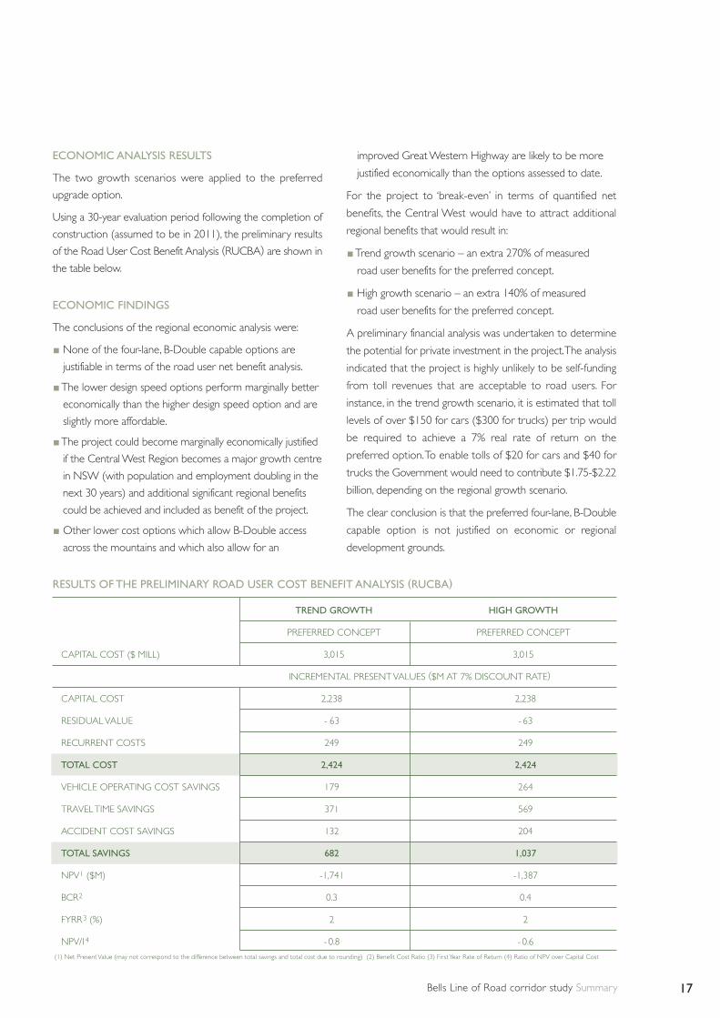
ECONOMIC ANALYSIS RESULTS
The two growth scenarios were applied to the preferred
upgrade option.
Using a 30-year evaluation period following the completion of
construction (assumed to be in 2011), the preliminary results
of the Road User Cost Benefit Analysis (RUCBA) are shown in
the table below.
ECONOMIC FINDINGS
The conclusions of the regional economic analysis were:
None of the four-lane, B-Double capable options are
justifiable in terms of the road user net benefit analysis.
The lower design speed options perform marginally better
economically than the higher design speed option and are
slightly more affordable.
The project could become marginally economically justified
if the Central West Region becomes a major growth centre
in NSW (with population and employment doubling in the
next 30 years) and additional significant regional benefits
could be achieved and included as benefit of the project.
Other lower cost options which allow B-Double access
across the mountains and which also allow for an
improved Great Western Highway are likely to be more
justified economically than the options assessed to date.
For the project to ‘break-even’ in terms of quantified net
benefits, the Central West would have to attract additional
regional benefits that would result in:
Trend growth scenario – an extra 270% of measured
road user benefits for the preferred concept.
High growth scenario – an extra 140% of measured
road user benefits for the preferred concept.
A preliminary financial analysis was undertaken to determine
the potential for private investment in the project.The analysis
indicated that the project is highly unlikely to be self-funding
from toll revenues that are acceptable to road users. For
instance, in the trend growth scenario, it is estimated that toll
levels of over $150 for cars ($300 for trucks) per trip would
be required to achieve a 7% real rate of return on the
preferred option.To enable tolls of $20 for cars and $40 for
trucks the Government would need to contribute $1.75-$2.22
billion, depending on the regional growth scenario.
The clear conclusion is that the preferred four-lane, B-Double
capable option is not justified on economic or regional
development grounds.
RESULTS OF THE PRELIMINARY ROAD USER COST BENEFIT ANALYSIS (RUCBA)
TREND GROWTH HIGH GROWTH
PREFERRED CONCEPT PREFERRED CONCEPT
CAPITAL COST ($ MILL) 3,015 3,015
INCREMENTAL PRESENT VALUES ($M AT 7% DISCOUNT RATE)
CAPITAL COST 2,238 2,238
RESIDUAL VALUE - 63 - 63
RECURRENT COSTS 249 249
TOTAL COST 2,424 2,424
VEHICLE OPERATING COST SAVINGS 179 264
TRAVEL TIME SAVINGS 371 569
ACCIDENT COST SAVINGS 132 204
TOTAL SAVINGS 682 1,037
NPV1 ($M) -1,741 -1,387
BCR2 0.3 0.4
FYRR3 (%) 2 2
NPV/I4 - 0.8 - 0.6
(1) Net Present Value (may not correspond to the difference between total savings and total cost due to rounding) (2) Benefit Cost Ratio (3) First Year Rate of Return (4) Ratio of NPV over Capital Cost

Bells Line of Road corridor study Summary18
The Bells Line of Road corridor study concluded that:
The Main Western Rail Line over the Blue Mountains
could be upgraded but any upgrade would be unlikely
to deliver significant benefits without major upgrades
east of Penrith and west of Lithgow.
All of the road upgrade options examined are feasible
from an engineering perspective.
None of the four-lane, B-Double road upgrade options
examined appear feasible from an economic or financial
perspective for a range of growth assumptions.
All of the four-lane B-Double capable upgrade options
would require the full regional and economic
development growth potential of the Central West
region to be realised over the next 30 years for the
project to progress towards being justified economically.
It is highly unlikely that private investment would be
forthcoming to progress this project without significant
government funding.
All of the four-lane, B-Double road upgrade options,
including the preferred option would have significant
environmental, social impacts.
Reserving a road corridor to enable future upgrade
works along BloR is complex and is likely to result in
the need for detailed and comprehensive environmental
assessment and approval from the Commonwealth and
State governments. It is also likely to required funding
for property acquisition of approximately $230 million
in 2004 dollars.
Conclusions


RTA/Pub. 05.283 ISBN 1920-907556


