Bengalla Mining Company Pty Limited Rehabilitation Management Plan Revision Date Description Author Reviewer Approved 0 16/07/07 Original Document M Walker Hansen Bailey D Munro Hansen Bailey J Torkington Bengalla Mine 1 25/10/07 Revision incorporating comments from DPI M Walker Hansen Bailey D Munro Hansen Bailey J Torkington Bengalla Mine 2 31/01/13 Revision for DA 211/94 (M4) GSS Environmental D Munro Hansen Bailey C. White Bengalla Mine 3 18/04/13 Final Rehabilitation Management Plan GSS Environmental D Munro Hansen Bailey A. Harburg Bengalla Mine
Transcript
Bengalla Mining Company Pty Limited
Rehabilitation Management Plan
Revision Date Description Author Reviewer Approved
0 16/07/07 Original Document M Walker Hansen Bailey
D Munro Hansen Bailey
J Torkington Bengalla Mine
1 25/10/07 Revision incorporating comments from DPI
M Walker Hansen Bailey
D Munro Hansen Bailey
J Torkington Bengalla Mine
2 31/01/13 Revision for DA 211/94 (M4)
GSS Environmental
D Munro Hansen Bailey
C. White Bengalla Mine
3 18/04/13 Final Rehabilitation Management Plan
GSS Environmental
D Munro Hansen Bailey
A. Harburg Bengalla Mine
Rehabilitation Management Plan
Ref: 130418 bengalla rehabilitation management plan.doc Page ii
Bengalla Mine (Bengalla) is located approximately 4 km west of Muswellbrook in the Upper Hunter Valley of NSW. Bengalla Mining Company (BMC) was granted development consent (DA 211/93) in 1996, in accordance with the supporting document Bengalla Coal Mine Environmental Impact Statement 1993 (Bengalla EIS). This approval allowed Bengalla to produce up to 8.7 Million tonnes per annum (Mtpa) of Run-of-Mine (ROM) coal for 21 years, and conduct other associated mining activities.
BMC was granted a consent modification to DA 211/93 (DA 211/93 (M1)) under Section 96(2) of the Environmental Planning and Assessment Act 1979 (EP&A Act) in November 2006 in accordance with the supporting document Statement of Environmental Effects – Modifications to Mining Operations 2006 (Bengalla SEE). This approval permits BMC to:
Increase the final landform height by up to 30 metres to 270 RL;
Relocate the overland conveyor and ROM Coal Hopper;
Upgrade the Coal Handling & Preparation Plant (CHPP) to allow two-stage washing;
Construct temporary tailings drying areas; and
Increase maximum allowable ROM coal production levels to 10.7 Mtpa.
In December 2007, BMC was granted a further modification to DA 211/93 (DA 211/93 (M2)) in accordance with the supporting Bengalla Mining Company Wantana Extension Statement of Environmental Effects 2007 (Wantana SEE). The Wantana SEE allows for the following:
Extension of mining operations into the 32 hectare Wantana Extension, entirely within the existing Mining Leases and Development Application Boundary;
Minor infrastructure modifications and revised maintenance manning strategy; and
Consolidation of in-pit facilities.
A modification to DA 211/93 (DA 211/93 (M3)) was granted under Section 75W of the EP&A Act in July 2008. This approval is supported by the Bengalla Mining Company Development Consent Modification Environmental Assessment 2008 (Bengalla Link Road EA) (Bengalla EA, 2008) and allows the construction of the Bengalla Link Road Stage 2 on the preferred alignment and for a delay in a component approved in DA 211/93 (M1).
A fourth modification to DA 211/93 (DA 211/93 (M4)) under Section 75W of the EP&A Act was approved in October 2011. This approval is supported by the Bengalla Mining Company Development Consent Modification Environmental Assessment 2010 (Bengalla Modification EA) (Bengalla EA, 2010).
Acceleration of mining operations within the Wantana Extension Area to align it with existing mining operations;
Extending the footprint and associated landform of the existing Overburden Emplacement Area (OEA) to the south-east;
Relocation of the already approved temporary OEA to the west of the current operations; and
Delaying the finalisation and rehabilitation of the northern face of the existing Overburden Emplacement Area.
1.2 Objectives
This Rehabilitation Management Plan (RMP) has been prepared to manage project specific and rehabilitation objectives associated with BMC’s mining operations. The objectives of this RMP are to:
Ensure that all relevant statutory requirements (specifically Schedule 3, Condition 41 of DA 211/93 (as modified)) and BMC policies and standards relating to rehabilitation are met;
Ensure that rehabilitation activities are applied consistently with the Mining Operations Plan (MOP) (BMC, 2012)
Develop an undulating, free-draining landform with an optimum land capability which supports agricultural land for predominately cattle grazing and native habitat;
The final landform will be undulating, with slopes generally to 10°, and up to a maximum of 18° on the low wall with effective erosion and sediment control measures; and
Describe the objectives for the final landform.
This RMP is implemented within active mining areas of the Bengalla DA Boundary (see Figure 1) and is applicable to the management of all rehabilitation activities at the site.
This RMP been developed in accordance with the requirements of Schedule 3, Condition 41 of DA 211/93 which are listed in Table 1.
Table 1 also presents additional conditions relevant to rehabilitation presented in DA 211/93 and indicates where each requirement has been addressed in this RMP.
Table 1 DA 211/93 RMP Conditions
Schedule 3 Environmental Performance Conditions
Number Condition Section
39
Rehabilitation Objectives
The Applicant shall rehabilitate the site to the satisfaction of the Executive Director, Mineral Resources in DRE. This rehabilitation must be generally consistent with the proposed rehabilitation strategy described in the EIS and EA, and comply with the objectives in Table 14.
Table 14: Rehabilitation Objectives
Feature Objective
Mine site (as a whole)
Safe, stable and non-polluting
Surface infrastructure
To be decommissioned and removed, unless the Director-General agrees otherwise
Overburden Dump
Rehabilitate, as soon as practicable, the working face of the overburden dump exposed to the Muswellbrook township and Denman Road. Where reasonable, rehabilitation will include high density tree planting
Eastern Overburden Dump
Contoured to no more than a 10 degree slope.
Other land affected by the development
Restore ecosystem function, including maintaining or establishing self-sustaining eco-systems comprised of:
Local native plant species;
Extensive areas of Class 3 Agricultural Capability Land; and
A landform consistent with the surrounding environment.
Final Void Safe, stable and non-polluting
Community Minimise the adverse socio-economic effects associated with mine closure
The Applicant shall carry out the rehabilitation of the site progressively, that is, as soon as practicable following disturbance
3.0
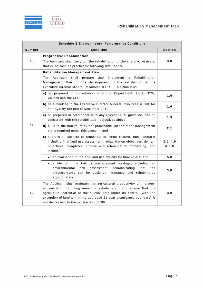
41
Rehabilitation Management Plan
The Applicant shall prepare and implement a Rehabilitation Management Plan for the development to the satisfaction of the Executive Director Mineral Resources in DRE. This plan must:
a) be prepared in consultation with the Department, OEH, NOW, Council and the CCC;
1.6
b) be submitted to the Executive Director Mineral Resources in DRE for approval by the end of December 2012;
1.6
c) be prepared in accordance with any relevant DRE guideline, and be consistent with the rehabilitation objectives above;
1.5
d) build to the maximum extent practicable, on the other management plans required under this consent; and
2.1
e) address all aspects of rehabilitation, mine closure, final landform including final land use assessment, rehabilitation objectives, domain objectives, completion criteria and rehabilitation monitoring, and include:
3.0, 4.0 & 5.0
an evaluation of the end land use options for final void/s; and 5.0
a life of mine tailings management strategy, including an environmental risk assessment demonstrating that the emplacements can be designed, managed and rehabilitated appropriately.
3.8
42
The Applicant shall maintain the agricultural productivity of the non-alluvial land not being mined or rehabilitated, and ensure that the agricultural potential of the alluvial flats under its control (with the exception of land within the approved 21 year disturbance boundary) is not decreased, to the satisfaction of DPI.
In addition to the above research program the Bengalla Modification EA indicated that an area of Class III Land Capability will be recreated on the OEA using material obtained from the Southern OEA Extension Area. This requirement is designed to mitigate the impacts that the Bengalla Modification EA had on the 9.6 ha of Class II land associated with the Southern OEA Extension. Additional detail into the status of these works is described in Section 3.2.
Current rehabilitation management practices described in the Bengalla Modification EA are currently and will continue to be implemented onsite and are described in Section 3.0 and Section 4.0.
1.5 Relevant Standards and Guidelines
This RMP has been compiled generally in accordance with the following guidelines and standards:
EDG03 – Guidelines to the Mining, Rehabilitation & Environmental Management Process (DTIRIS, 2012);
Strategic Framework for Mine Closure (ANZMEC & MCA, 2000);
Mine Closure and Completion – Leading Practice Sustainable Development Program for the Mining Industry (DITR, 2006a);
Mine Rehabilitation – Leading Practice Sustainable Development Program for the Mining Industry (DITR, 2006b); and
A Rehabilitation Manual for Australian Streams (Vol 2) (Rutherfurd et al., 2000).
1.6 Bengalla Mining Operations Plan
BMC conducts rehabilitation in accordance with DA 211/93 (and supporting documentation) and the MOP (BMC MOP, 2012). The current approved MOP outlines the proposed operational and environmental activities planned for Bengalla from 1 January 2013 until 26 June 2015.
1.7 Regulatory Consultation
This RMP has been prepared to the satisfaction of the Department of Trade & Investment, Regional Infrastructure and Services (DTIRIS) Division of Resources and Energy (DRE) and in consultation with the Department of Planning and Infrastructure (DP&I).
Schedule 3, Condition 41 (b) of DA 211/93 states that the RMP must be submitted to the Executive Director Mineral Resources in the DRE for approval by the end of December 2012. On 17 December 2012, DP&I granted BMC an extension of one month to allow the submission of the RMP by 31 January 2013. The draft RMP was submitted to DRE and DP&I on 31 January 2013. A copy of this correspondence is provided in Appendix A.
In accordance with DA 211/93, Schedule 3, Condition 41 (a) a copy of this RMP was provided to the Office of Environment and Heritage (OEH), DP&I, NSW Office of Water (NOW), Muswellbrook Shire Council (MSC) and the Bengalla CCC for consultation during its preparation. A copy of this correspondence included in Appendix A.
DRE provided a response to the draft RMP on 25 March 2013 and indicated that they were satisfied with the content of the RMP and a final RMP should be issued for approval.
DP&I indicated that that they would leave comment on the RMP to DRE as they are the approval body for this plan.
EPA and NOW indicated they had no comment on the RMP. No correspondence in relation to the RMP was provided by MSC.
All correspondence received is included in Appendix A.
BMC has a comprehensive and well-developed ISO14001-certified Environmental Management System (EMS) in place to fulfil its commitment to achieving high standards of environmental management and community engagement. The EMS is comprised of environmental procedures and standards for particular aspects and impacts of its operations.
Procedures and standards are regularly reviewed and audited as part of the continuous improvements of BMC’s EMS to adopt relevant industry best practice and technology. The promotion of successful rehabilitation will ensure the long term sustainability of the final landform.
The primary objective of rehabilitation at Bengalla is to develop a free-draining landform compatible with surrounding land uses. The rehabilitation measures described in this updated RMP will continue to be implemented over the life of mining at Bengalla.
The final landform will contain slopes generally to 10°, and up to a maximum of 18° on the low wall. Erosion and sediment control and water management structures will be incorporated into the landform as rehabilitation progresses. The landform will be predominately revegetated to improved pastures and trees.
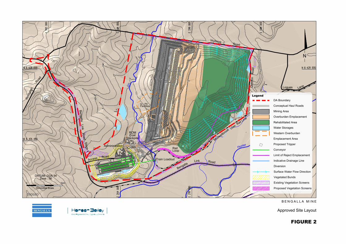
Figure 2 illustrates the approved final landform as at 2017, incorporating the activities associated with the Southern OEA. Land capability associated with the active mining and rehabilitation areas as presented in the MOP (BMC MOP, 2012) for Bengalla is shown on Figure 3. Stormwater runoff and drainage from the landform will continue to be managed in accordance with the approved Bengalla Water Management Plan (BMC WMP, 2012).
The Bengalla Modification EA noted that a portion of the OEA would be rehabilitated to comply with the requirements of Land Capability Class III land (where slopes are <3% slope).
BMC has established an area of approximately 5.7 ha to Class III Land Capability where slopes are <3% (see Figure 3). Black Vertosol soils applied to a depth of at least 200 mm gained from the Southern OEA Extension were utilised to assist in the re-creation of Class III land.
This area was seeded with pasture vegetation in late 2012 and will be monitored as part of the annual rehabilitation audit with results presented in the Annual Review.
Prior to disturbing any new areas, a site inspection and Ground Disturbance Permit (GDP) is completed by the Environmental Specialist (or delegate) to identify any environmental or Aboriginal archaeological issues associated with the disturbance of the area in accordance with EP 5.1 Rehabilitation.
There is limited existing remnant native tree cover within the approved disturbance area at Bengalla. However, prior to undertaking any disturbance, all habitat trees or seed trees will be identified. Prior to, and during clearing, where available, seed is collected and any fauna present is relocated by an appropriately qualified person in accordance with EP 10.2.
No disturbance of any area occurs until the respective area has been approved via the Environmental Specialist (or delegate) in the GDP. Vegetation is then cleared and windrowed then placed on rehabilitation for habitat enhancement. Other material is placed in-pit.
Topsoil (approximately 100 mm – 150 mm) is stripped in accordance with the MOP (BMC, 2012) and EP 5.1 and either directly placed on shaped spoil areas for rehabilitation or in circumstances where this is not possible, it is stockpiled for later use in rehabilitation (see Section 3.3).
3.2.3 Southern OEA Extension Area Topsoil Stripping
As described in the Bengalla Modification EA suitable topsoil (and subsoil) from each of the soil types within the Southern OEA Extension was stripped prior to overburden emplacement. To ensure that the better quality topsoil is not mixed with the inferior subsoil, selective soil stripping practices enabled BMC to utilise this higher quality material more effectively on its rehabilitation.
This soil needs to be separated from other soils in order to maintain its integrity, as it is planned to be used in rehabilitation to create Class III Agricultural Suitability land as per Modification 4 of the Development Consent.
Selective soil stripping practices involved BMC mapping out each of the various soil types within the Southern OEA Extension Area and then using suitable machinery to extract each of the various topsoil units. All soil material was extracted whilst in a slightly moist condition.
Only subsoils from the Black Vertosol soils were extracted for use on rehabilitation as the remaining soil type subsoils were deemed unsuitable. By accurately mapping and extracting suitable topsoil from the Southern OEA Extension Area, an estimated 70,900 m3 of topsoil and 24,500 m3 of subsoil was obtained for use in rehabilitation.
Black Vertosol soils topsoil and subsoil resources were stored separately from all other topsoil resource to ensure mixing did not occur of the best quality material.
Topsoil gained from the Southern OEA Extension Area has been used to assist BMC in establishing areas of Class III Land Capability on its OEA as discussed in Section 3.2.3.
3.3 Topsoil Stockpiling
Stripped topsoil is generally placed directly onto reshaped overburden, however it may be necessary to stockpile topsoil for use in rehabilitation at a later date. In accordance with EP 5.1, all topsoil stockpiles are located in designated areas and constructed to a shape and depth as specified in the MOP (BMC, 2012). Each topsoil stockpile is pegged, marked with signage and the topsoil stockpile surveyed for its volume. The topsoil stockpiles will be:
Located as close as practicable and readily accessible to re-spreading areas;
Located where they will not interfere with present and future mining and ancillary operations;
At least 10 m from trees or watercourses; and
In areas that will allow free drainage and minimal soil erosion.
Topsoil stockpiles that will not be used for longer than three months will be shaped, fertilised and revegetated with a cover crop specified by the Environmental Specialist to provide initial stability, maintain soil viability and minimise erosion. When removing soil from stockpiles to place on shaped areas, all practical measures (including spraying and/or removing the top 20 mm as proven to be effective through trials) will be taken to remove weed seed banks prior to re-spreading.
3.4 Shaping & Topsoiling
Once mining activities in an area have ceased, the overburden is shaped according to the final landform design (see Figure 2). Topsoil is then re-spread on the shaped areas to a minimum depth of 100 mm, in accordance with EP 5.1. Contour banks are constructed at regular intervals down the slope of the rehabilitation area. The area is then rock-raked to generally remove large rocks. Areas are then scarified along the contour to assist in seed germination and water infiltration.
Revegetation is undertaken progressively and as soon as practicable after the completion of surface preparation. Inert capping material and topsoil is usually spread over areas to be rehabilitated as soon as possible, to maintain topsoil quality and take advantage of native seed-banks if present. This minimises the areas of disturbed land, reduces future rehabilitation liabilities, minimises visual impacts and helps suppress the potential for wind-blown dust and erosion. Progressive rehabilitation is undertaken at Bengalla as per EP 5.1 Rehabilitation.
Seeding of a rehabilitation area commences as soon as practical after raking using either a tractor mounted seed spreader or direct hand seeding. Generally, pasture areas and trees and shrub areas will be sown separately. Where utilised, tube stock may be planted in rip lines at approximately 5 m spacing and in an irregular pattern along the contour to achieve as natural a result as possible. The typical pasture and tree species mixture used for revegetation include local endemic species and are shown in Appendix B.
3.6 Overburden Emplacement Area
3.6.1 Southern Overburden Emplacement Area
The Southern OEA Extension involves the development of the existing OEA further towards the south-east and will generate approximately 10 Mlcm of additional overburden emplacement capacity at Bengalla. BMC commenced emplacing material in the Southern OEA Extension area in fourth quarter 2012 and is scheduled to be completed by 2013. Rehabilitation of the Southern OEA Extension will be conducted in accordance with the MOP (BMC, 2012) and this RMP.
Topsoil from the Southern OEA Extension Area was collected for ultimate reuse on rehabilitation (see Section 3.2.2).
3.6.2 Western Overburden Emplacement Area
The temporary Western OEA described in the Bengalla Modification EA has not yet been constructed in its currently approved location (see Figure 2).
BMC plans to utilise the Western OEA only if absolutely required. Should the Western OEA be required, it is planned to be constructed in stages. Prior to use, suitable topsoil from the proposed Western OEA location will be extracted for use on rehabilitation.
3.6.3 Northern Overburden Emplacement Area
As described in the Bengalla Modification EA, the northern face of the existing OEA has been steepened to accommodate additional overburden capacity and to maximise coal recovery.
BMC will continue to emplace overburden and temporarily rehabilitate this area until it will be reshaped and topsoiled for permanent rehabilitation.
3.7 Completion Criteria
Initial completion criteria for the short-term (annual), medium-term (< 5 yrs) and long- term (life of mine) have been developed to achieve the site rehabilitation objectives and are shown in Table 2. Rehabilitation that achieves the completion criteria will be considered to be sustainable without ongoing management and therefore suitable for mining lease relinquishment.
The completion criteria include success indicators and monitoring requirements to monitor the successful establishment of rehabilitation and trigger remedial action, where necessary. This will ensure that rehabilitation achieves the completion criteria in a suitable timeframe.
Completion criteria for Bengalla continue to be guided by concepts and criteria presented in Hannan (2003) and Nichols (2004) and refinement of on-site practices (for example seeding mixes and species selection).
measures as necessary Note: The preliminary and conceptual completion criteria will be revised through monitoring. ^ Monitoring regime will be annually or as otherwise indicated. * Conceptual completion criteria as presented in Hannan (2003). ** Conceptual completion criteria as provided by the Australian Coal Association Research Program (ACARP) (Nichols, 2004).
Bengalla does not have any tailings dams to store reject material and hence DA 211/93 Condition 41 (e) is not applicable to current operations.
Consistent with existing practices, the two waste streams from the CHPP process, tailings and coarse reject are combined and stored in a reject bin before being hauled back to be co-disposed in the Main OEA where it is dried in cells, buried within the Main OEA and capped with a minimum of 5 m of inert overburden material. Final landform shaping and rehabilitation is then undertaken.
3.9 Agricultural Productivity of BMC Land
BMC has a long history of maintaining the agricultural productivity on its agricultural lands. Between 1995 and 2004, Bengalla Agricultural Company was operated to manage the agricultural land acquired by BMC that was not being used for active mining. During this period, Bengalla Agricultural Company became one of the largest milk producers in the Hunter Valley operating three dairies with milk production peaking at over 5.3 ML in 2002 compared to the 3.3 ML produced in 1992 from the same area. In addition to the dairies, Bengalla Agricultural Company also operated a thoroughbred stud, standing three stallions as well as broodmares and weanling and yearling preparation along with dryland beef grazing. Irrigated cropping was also carried out.
In 2004 the Bengalla Agricultural Company was restructured which permitted the management of all BMC owned agricultural enterprises to be transferred to individual licensees. This practice continues today with productive agricultural land operated under seven individual licensing agreements. The private licensing arrangements have ensured the ongoing success of the dairy operations, a thoroughbred stud and brood mare farm, beef cattle breeding, lucerne hay production and industrial hemp production.
Current (2012) agricultural operations leased under private licensing arrangements include:
Dairying, calving approximately 900 cows pa on the Hunter River Alluvials producing 4.7 million litres of milk;
Operate a thoroughbred stud and brood mare farm, standing 3 stallions and agisting 38 mares and 26 young horses permanently, increasing in the season;
Over 1,500 t of hay (mainly Lucerne) for sale as well as producing hay for on farm use;
Harvest 100 t of industrial hemp as an experimental crop for the embryonic Hunter Valley hemp fibre industry; and
Beef breeding cows selling over 900 fat and store stock pa.
BMC will continue to implement private licensing arrangements to ensure that the agricultural productivity of the BMC land (not required for mining) is maintained.
BMC will continue to undertake regular rehabilitation inspection to assess its ongoing success.
This regular inspection consists of a reconnaissance level/on site walk through assessment, which includes observations of rehabilitation and some design recommendations for remediation of existing and future rehabilitation. The regular inspection also includes the review of BMC’s initial rehabilitation completion criteria and other relevant statutory rehabilitation obligations including:
Should BMC not be granted the relevant approvals to enable mining operations to continue beyond the extent of the approved Bengalla mine which is currently being sought, (see Figure 2) then the following will be implemented in relation to mine closure.
The key objective of site rehabilitation is to achieve an optimum post-mining land capability suitable for supporting a combination of grazing and native habitat land use. Detailed rehabilitation objectives and completion criteria, consistent with these post-mining land use objectives are listed in Table 2.
5.2 Rehabilitation Domains
Primary domains can be defined as land management units within a mine site, usually with unique operational and functional purpose and therefore similar geophysical characteristics. Secondary domains are land management units characterised by a similar post mining land use objective (BMC MOP, 2012).
It is likely that most domains will require a different rehabilitation methodology to achieve the intended post-mining land use. Domains for Bengalla have been determined in consideration of the specific requirements of the mining location and local environment. The two key domains for Bengalla are outlined below:
Final Void Final voids will be used for water storage post-mining. The objective is for the final voids to be safe, stable and non-polluting.
Infrastructure Areas
Mining infrastructure within the identified disturbance area will be removed if no longer required; and the affected lands rehabilitated or retained if an alternate industrial/mining use is determined to be the final land use in the future.
Overburden Emplacements, including reject emplacement
Undulating, stable, free draining landform. The final landform will incorporate the existing rehabilitated landforms to ultimately be consistent with the surrounding landscape features.
Secondary Domain
Water Management Areas
The drainage pattern of the final landform will be designed to integrate with the surrounding catchments and will be revegetated to achieve long term stability and erosion control and also to harmonise with more general rehabilitation and revegetation strategies.
Rehabilitation Area - Class III Pastures with Class III Land capability
Rehabilitation Area – Class IV and V (Pasture)
Approximately 70% of mined land re-established as stable pasture areas
Rehabilitation Area – Class IV and V (Native Vegetation)
Approximately 30% of mined land re-established as stable native vegetation, with the majority of the eastern OEA face as native vegetation
Source BMC MOP 2012
5.3 Post-Mining Land Use
Investigations for the Bengalla Modification EA were undertaken to determine feasible land uses on rehabilitated land considering land slope, class, water requirements and soil types.
Cattle grazing was found to satisfy corporate and regulatory requirements as a final land use at Bengalla and would be fully compatible with the historical land use (prior to mining) surrounding land use and landforms in regards to visual amenity. Cattle grazing was also found to have a high level of acceptance from the local community and would maximise the likelihood of long-term landform stability.
A combination of grazing and limited native bushland regeneration has therefore been adopted as the preferred post-mining land use in suitable areas of the site, with a focus on linking remnant vegetation with rehabilitation.
Ongoing monitoring and management of environmental performance will continue to be undertaken for five years after mine closure or until such time as monitoring results demonstrate that the site meets the closure criteria. Detailed closure criteria and associated monitoring and maintenance programs will be included in the Final Void Management Plan (see Section 5.6). Mine closure monitoring will include at least the following:
Rehabilitation and closure completion criteria/success indicators;
Groundwater;
Surface water; and
Air quality.
5.5 Performance Measurement
The performance of the rehabilitation at Bengalla at mine closure will be monitored in accordance with the monitoring programs specified in Table 2. The assessment of the monitoring results will enable the confirmation of achievement of the success indicators and associated completion criteria.
5.6 Final Void
A detailed Final Void Management Plan will be developed included in a further revision of this RMP within two years of mine closure, however, preliminary final void justification, design criteria and control measures are provided below utilising available information. These will be subject to change when Bengalla pursues mining approvals beyond the currently approved limit.
Should BMC not be granted the relevant approvals to enable mining operations to continue beyond the extent of the approved Bengalla mine then a Final Void Management Plan will be completed within two years prior to the completion of mining in consultation with the relevant authorities and to the satisfaction of DP&I.
Based on the currently approved mine plan at Bengalla, a final void will be created as shown on Figure 2. The void will be aligned generally north-south and will be retained as an open water body.
The currently approved location of the final void is at the economic limit of approved open cut mining at this stage and thus, has no alternative location.
The currently approved void will remain as an open water body as all available overburden will be used to create undulating and a free-draining overburden emplacement. On this basis, is not environmentally or economically feasible to alter the use or location of the final void at this stage.
The Groundwater Impact Assessment for the Bengalla 2010 EA confirmed that an equilibrium void lake water level will be reached after more than 200 years. At this level the inflows to the void from groundwater and surface water runoff are balanced by evaporation from the surface of the void water storage.
The equilibrium void water level is approximately 150 m below the crest of the void and there is therefore a very low risk that the void would overtop even during an extreme rainfall event. The equilibrium void water level is also well below (in the order of 75 – 105 m) the pre-mining groundwater levels. Hence the open void will act as a groundwater sink and no contamination of groundwater will occur (AGE, 2006).
The location and use of the final void will not result in any adverse environmental impacts and is situated well above the 1:100 Hunter River flood level. The location and use of the final void will continue to be investigated during detailed mine closure planning.
5.7 Design Criteria
The final void will be managed and designed such that the low wall is at a slope of no greater than 18° and will be rehabilitated with pasture species suitable for surface stability. Benches will be incorporated at regular intervals along the low wall where practical (Hannan, 2003).
The steep slope of the high wall will be designed to a stable gradient, based on assessments of geotechnical stability and risk. Fencing will be constructed across the high wall to restrict cattle and pedestrian access. A steep ditch and bund wall may also be constructed at a short distance back from the high wall, so as to prevent inadvertent vehicular access.
Water management structures will be utilised to divert as much of the surrounding surface water catchment away from the void. Diversion banks with a capacity to convey a relevant level of peak runoff storm events will be constructed above the low wall to convey and redirect runoff.
5.8 Community Issues Associated with Mine Closure
In the unlikely event that a future approval will not be granted, then BMC would cease operations in 2017. The significance of these cessation impacts would depend on the degree to which any displaced workers and their families remain within the region, even if they remain unemployed. If there are other as-yet-unconstructed or unknown projects operating at that time, then the impacts of the gradual decrease of the Project workforce will be lessened as other projects absorb the excess labour.
As discussed in Section 5.1 BMC has submitted an application to the DP&I to facilitate the continuation of mining for a further 24 years. As discussed in Section 5.6 BMC will develop a Final Void Management Plan within two years of mine closure which will address any community and social issues associated with the cessation of mining.
This RMP will be reviewed and revised (in consultation with relevant government agencies) each 5 years, or sooner in accordance with Schedule 5, Condition 4 of DA 211/93 if any of the following occur:
Within 3 months of the submission of an:
o Annual review in accordance with Schedule 5, Condition 3 of DA 211/93;
o An incident report under Schedule 5, Condition 7 of DA 211/93;
o An audit under Schedule 5, Condition 9 of DA 211/93; and
o Any Modification to DA 211/93.
6.2 Reporting an Incident
Schedule 5, Conditions 2 and 7 of DA 211/93 requires BMC to report any incident that has caused, or has the potential to cause, significant risk of material harm to either human health or the environment, at the earliest opportunity.
Incidents will be reported to DP&I and any other relevant regulatory agencies required under the EPL, within seven days, and will comprise a detailed report on the incident.
6.3 Public Access to Information
In accordance with Schedule 5, Condition 3 and Condition 11 of DA 211/93 (M4), BMC will regularly (in the form of the Annual Review) prepare a summary of monitoring results required by DA 211/93 and make these publicly available on the Bengalla website.
7.0 CONTINUOUS IMPROVEMENT
BMC continually strives to improve Bengalla’s environmental performance by applying the principles of best practice through the continued implementation of its ISO14001-certified EMS.
Reasonable and feasible new best practice technologies will be investigated and adopted where relevant and progress will continue to be monitored using the performance indicators detailed in Section 2.1.
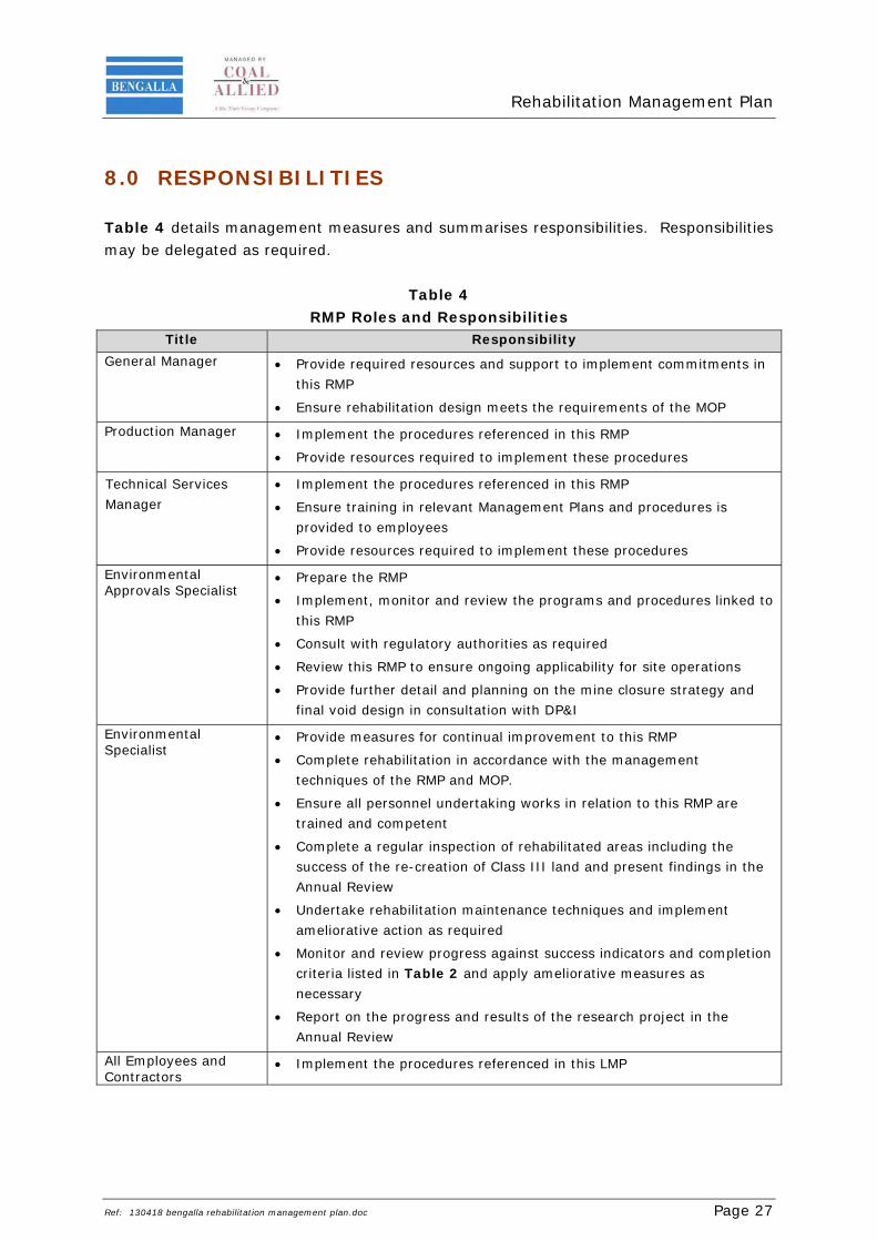
8.0 RESPONSIBILITIES Table 4 details management measures and summarises responsibilities. Responsibilities may be delegated as required.
Table 4 RMP Roles and Responsibilities
Title Responsibility General Manager Provide required resources and support to implement commitments in
this RMP
Ensure rehabilitation design meets the requirements of the MOP
Production Manager Implement the procedures referenced in this RMP
Provide resources required to implement these procedures
Technical Services Manager
Implement the procedures referenced in this RMP
Ensure training in relevant Management Plans and procedures is provided to employees
Provide resources required to implement these procedures
Environmental Approvals Specialist
Prepare the RMP
Implement, monitor and review the programs and procedures linked to this RMP
Consult with regulatory authorities as required
Review this RMP to ensure ongoing applicability for site operations
Provide further detail and planning on the mine closure strategy and final void design in consultation with DP&I
Environmental Specialist
Provide measures for continual improvement to this RMP
Complete rehabilitation in accordance with the management techniques of the RMP and MOP.
Ensure all personnel undertaking works in relation to this RMP are trained and competent
Complete a regular inspection of rehabilitated areas including the success of the re-creation of Class III land and present findings in the Annual Review
Undertake rehabilitation maintenance techniques and implement ameliorative action as required
Monitor and review progress against success indicators and completion criteria listed in Table 2 and apply ameliorative measures as necessary
Report on the progress and results of the research project in the Annual Review
Bengalla Mine (2010) BMC Development Consent Modification: Environmental Assessment.
Charman P.E. and Murphy B.W. (Eds) (2000) Soils: Their Properties and Management. 2nd Edition (Oxford University Press, Australia).
Cummingham G.M., Higginson F.R, Riddler A.M.H and Emery K.A. (1988) Rural Land Capability Mapping, Soil Conservation Service of NSW. Sydney, NSW.
Department of Industry, Tourism and Resources (DITR) (2006a). Mine Closure and Completion – Leading Practice Sustainable Development Program for the Mining Industry.
Department of Industry, Tourism and Resources (DITR) (2006b). Mine Rehabilitation – Leading Practice Sustainable Development Program for the Mining Industry.
Department of Mineral Resources (1999) Synoptic Plan: Integrated Landscapes for Coal Mine Rehabilitation in the Hunter Valley of New South Wales.
Department of Planning (2009) Consolidated Modifications to Development Consent – Bengalla Coal Mine (DA 211/93 (M1, M2, M3)).
Department of Primary Industries – Mineral Resources Division (2006) Guidelines to the Mining, Rehabilitation and Environmental Management Process.
Department of Trade and Investment Regional Infrastructure and Services (DTIRIS) (2012) EDG03 – Guidelines to the Mining, Rehabilitation & Environmental Management Process.
Elliot, G.L. and Veness, R.A. (1981). Selection of Topdressing Material for Rehabilitation of Disturbed Areas in the Hunter Valley, J. Soils Cons. NSW 37 37-40.
GSS Environmental (2004) Post Mining Land Use Options Report.
Gunn, R.H., Beattie, J.A., Reid, R.E., and van de Graff, R. H. M. (1998) Australian Soil and Land Survey Handbook – Guidelines for conducting Surveys (Inkata Press, Australia).
Hannan Environmental Management (2003) Bengalla Mine Closure Strategy and Plan.
Hansen Bailey (2010) Bengalla Mine Development Consent Modification Environmental Assessment.
Hazelton P.A and Murphy B.W. (2007) Interpreting Soil Test Results (CSIRO Publication, Australia).
HLA Envirosciences (1993) Environmental Impact Statement for Bengalla Open Cut Coal Mine.
Klingebiel, A.A. and Montgomery, P.H. (1961) Land Capability Classification, Agriculture Handbook No. 210. United States Department of Agriculture (Washington, D.C., U.S.A).
Kovac M. and Lawrie J.L. 1991 Soil landscapes of the Singleton 1:250,000 Sheet. Soil Conservation Service of NSW, Sydney.
Nichols, O.G (2004) Development of rehabilitation criteria for native ecosystem establishment on coal mine in the Hunter Valley. Australian Coal Association Research Program Project C13048.
Rutherfurd I., Jerie K. and Marsh N. (2000) A Rehabilitation Manual for Australian Streams Volume 1. Cooperative Research Centre for Catchment Hydrology and Land and Water Resources Research and Development Corporation, Canberra, ACT.
BCM Bank cubic metres - a measure of volumes mined, equal to the weight of material divided by its specific gravity
BMC Bengalla Mining Company Pty Limited
BMP Blast Management Plan
BoM Australian Bureau of Meteorology
DA Development Application
DP&I NSW Department of Planning and Infrastructure
EIS Environmental Impact Statement
EMS Environmental Management System
EMP Environmental Management Program
EPL Environmental Protection Licence
Mlcm Million loose cubic meters
MOP Mining Operations Plan
MSC Muswellbrook Shire Council
Mtpa Mega tonnes per annum
OEA Overburden Emplacement Area
OEH NSW Office of Environment and Heritage
OGM Organic Growth Medium
RMP Rehabilitation Management Plan
ROM Run of Mine
APPENDIX A REGULATORY CORRESPONDENCE
1
Jason Martin
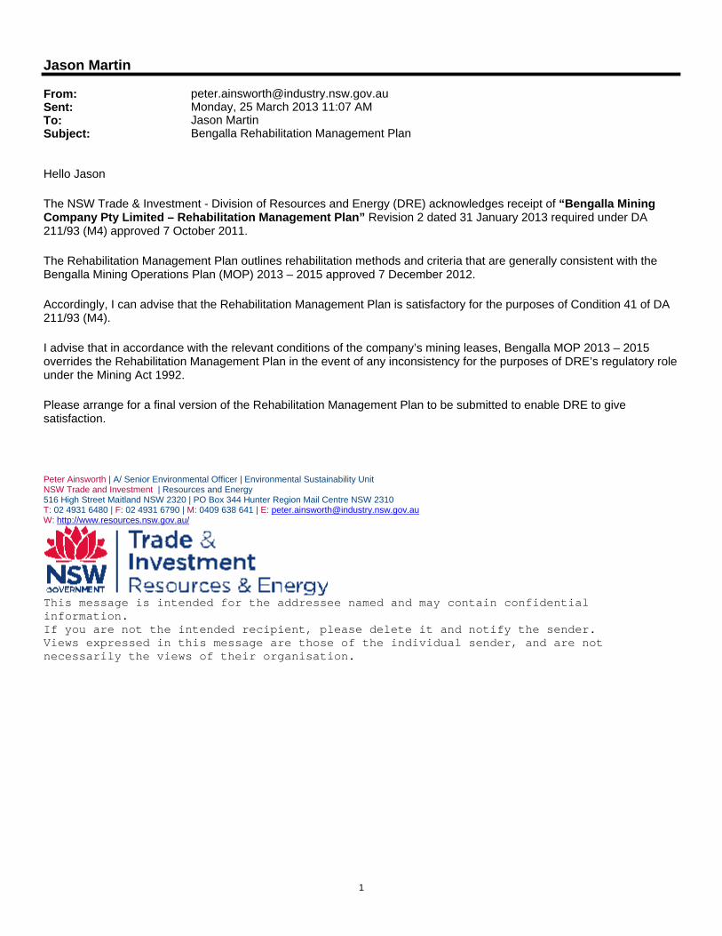
From: [email protected]: Monday, 25 March 2013 11:07 AMTo: Jason MartinSubject: Bengalla Rehabilitation Management Plan
Hello Jason The NSW Trade & Investment - Division of Resources and Energy (DRE) acknowledges receipt of “Bengalla Mining Company Pty Limited – Rehabilitation Management Plan” Revision 2 dated 31 January 2013 required under DA 211/93 (M4) approved 7 October 2011. The Rehabilitation Management Plan outlines rehabilitation methods and criteria that are generally consistent with the Bengalla Mining Operations Plan (MOP) 2013 – 2015 approved 7 December 2012. Accordingly, I can advise that the Rehabilitation Management Plan is satisfactory for the purposes of Condition 41 of DA 211/93 (M4). I advise that in accordance with the relevant conditions of the company’s mining leases, Bengalla MOP 2013 – 2015 overrides the Rehabilitation Management Plan in the event of any inconsistency for the purposes of DRE’s regulatory role under the Mining Act 1992. Please arrange for a final version of the Rehabilitation Management Plan to be submitted to enable DRE to give satisfaction. Peter Ainsworth | A/ Senior Environmental Officer | Environmental Sustainability Unit NSW Trade and Investment | Resources and Energy 516 High Street Maitland NSW 2320 | PO Box 344 Hunter Region Mail Centre NSW 2310 T: 02 4931 6480 | F: 02 4931 6790 | M: 0409 638 641 | E: [email protected] W: http://www.resources.nsw.gov.au/
This message is intended for the addressee named and may contain confidential information. If you are not the intended recipient, please delete it and notify the sender. Views expressed in this message are those of the individual sender, and are not necessarily the views of their organisation.
1
Jason Martin
From: Scott Brooks [[email protected]]Sent: Monday, 17 December 2012 2:01 PMTo: Jason MartinCc: Benjamin Harrison; [email protected]: Re: Bengalla Management Plans
Jason, Ben and I discussed this matter last Friday. We agreed that we could delay their due date to the 31st January 2013. I confirm that the due date of the Bengalla management plans as outlined below is now the 31st January 2013. Scott Scott Brooks Team Leader Compliance (Mining) Mining & Industry Projects Department of Planning & Infrastructure Suite 14, Level 1, 1 Civic Av PO Box 3145 Singleton NSW 2330 http://www.planning.nsw.gov.au E: [email protected] P: 02 6575 3401 | | M: 0419 970924 F: 02 65753415
Please consider the environment before deciding to print this e-mail. >>> "Jason Martin" <[email protected]> 12/17/2012 1:43 pm >>> Hi Scott and Ben, With reference to your phone discussion with Craig White from Bengalla last week I would just like to confirm that you have granted an extension of time, to the 31 January 2013, for the submission of the remaining management plans associated with DA 211/93 (as modified). The remaining management plans include:
Schedule 3, Condition 41 ‐ Rehabilitation Management Plan; and
Schedule 5, Condition 1 ‐ Environmental Management Strategy. If you could please confirm that the abovementioned management plans are now due to be submitted to DP&I by the 31 January 2013 that would be appreciated. Please call to discuss as required. Regards, Jason. Jason Martin Environmental Scientist HANSEN BAILEY Tel: (02) 6575 2010 Fax: (02) 6575 2001
APPENDIX B
REHABILITATION SPECIES PLANTINGS
Plant Species Directly Seeded at Bengalla (AEMR, 2010)
Pastures Mix / Tree Varieties Seeding Rate (kg / ha) Japanese millet or Shirrohie millet 15 (summer crop)


![CITATION: Karen Alison Power v HSE Mining Pty Ltd · CITATION: Karen Alison Power v HSE Mining Pty Ltd [2007] NTMC 002 PARTIES: Karen Alison Power -v- HSE Mining Pty Ltd TITLE OF](https://static.documents.pub/doc/80x56/60b2c7f6b521634e584fcf16/citation-karen-alison-power-v-hse-mining-pty-ltd-citation-karen-alison-power-v.jpg)


