58
CLIENT: Department of Transport STATUS: E REPORT No.: R190211 ISSUE DATE: 09 Dec 2019 Benthic Communities and Habitat Port Hedland Spoilbank Marina
CLIENT: Department of Transport
STATUS: E REPORT No.: R190211
ISSUE DATE: 09 Dec 2019
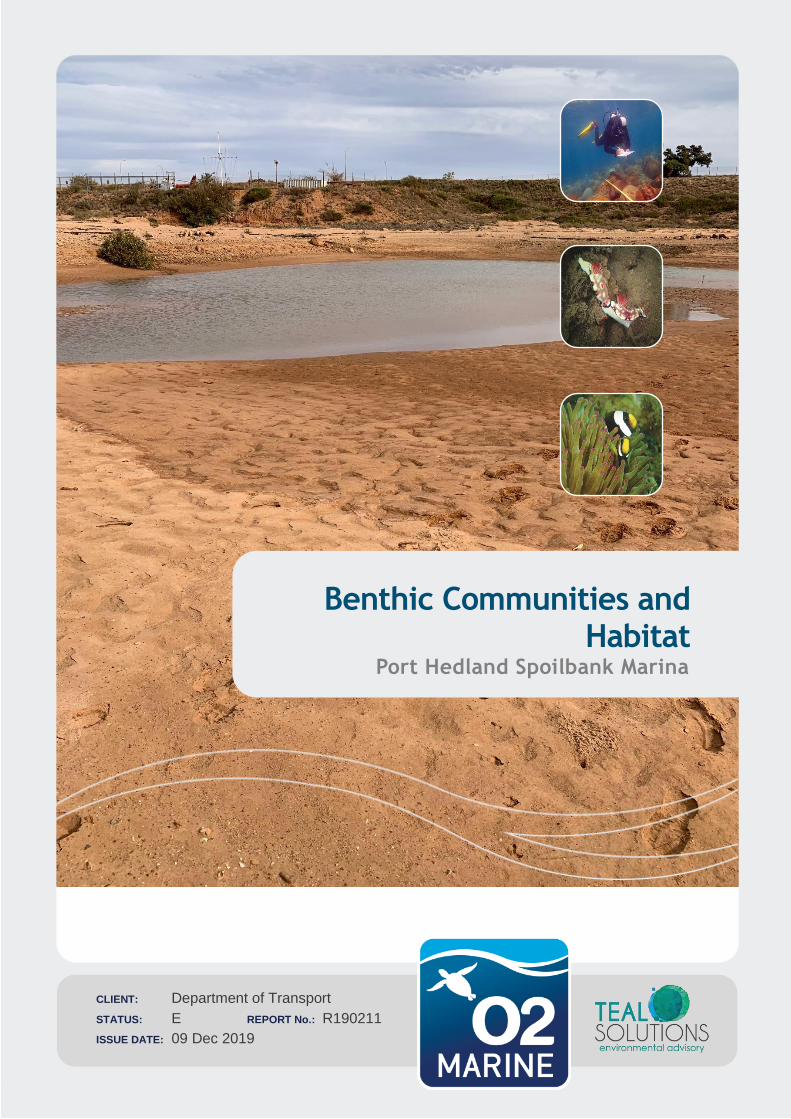
Benthic Communities and Habitat
Port Hedland Spoilbank Marina
1 Client Name Department of Transport
Project Name: Benthic Community and Habitat Report
Project WAU-0020 Doc: R190211
Important Note
This report and all its components (including images, audio, video, text) is copyright. Apart from fair
dealing for the purposes of private study, research, criticism or review as permitted under the Copyright
Act 1968, no part may be reproduced, copied, transmitted in any form or by any means (electronic,
mechanical or graphic) without the prior written permission of O2 Marine and Teal Solutions.
This report has been prepared by O2 Marine in collaboration with Teal Solutions for the sole use of the
Department of Transport (herein, ‘the client’), for a specific site (herein ‘the site’, the specific purpose
specified in Section 1 of this report (herein ‘the purpose’). This report is strictly limited for use by the
client, to the purpose and site and may not be used for any other purposes.
Third parties, excluding regulatory agencies assessing an application in relation to the purpose, may
not rely on this report. O2 Marine and Teal Solutions waives all liability to any third-party loss, damage,
liability or claim arising out of or incidental to a third-party publishing, using or relying on the facts,
content, opinions or subject matter contained in this report.
O2 Marine and Teal Solution waives all responsibility for loss or damage where the accuracy and
effectiveness of information provided by the Client or other third parties was inaccurate or not up to date
and was relied upon, wholly or in part in reporting.
1 Client Name Department of Transport
Project Name: Benthic Community and Habitat Report
Project WAU-0020 Doc: R190211
WA Marine Pty Ltd t/as O2 Marine ACN 168 014 819
Originating Office – Southwest
Suite 5, 18 Griffin Drive, Dunsborough WA 6281
T 1300 739 447 | [email protected]
Version Register
Version Status Author Reviewer Change from
Previous Version
Authorised for Release
(signed and dated)
Draft A C Del Deo B Hegge C Lane
Rev B B C Del Deo B Hegge
Rev C C C Del Deo B Hegge
Rev D D C Del Deo M Spencer B Hegge
Rev E E C Del Deo M Spencer B Hegge
Transmission Register
Controlled copies of this document are issued to the persons/companies listed below. Any copy of this
report held by persons not listed in this register is deemed uncontrolled. Updated versions of this report
if issued will be released to all parties listed below via the email address listed.
Name Email Address
Bradford Jason [email protected]
Matthew Spence [email protected]
1 Client Name Department of Transport
Project Name: Benthic Community and Habitat Report
Project WAU-0020 Doc: R190211
Acronyms and Abbreviations
Acronyms/Abbreviation Description
BCH Benthic Communities and Habitats
CALM Conservation and Land Management
DSN Dredging Science Node
EIA Environmental Impact Assessment
EPA Environmental Protection Authority
GIS Geographic information system
ha Hectares
km kilometres
LAT Lowest Astronomical Tide
LAU Local assessment unit
m Meter
m3 Cubic Meter
Pty Ltd Proprietary Limited
WA Western Australia
WAMSI Western Australian Marine Science Institution
Table of Contents
1. Introduction 6
Background 6
Project Description 7
Scope and Objectives 2
Legislation and Guidelines 2
2. Existing Environment 4
Overview 4
Climate and Oceanography 4
Geomorphology 4
Marine Water Quality 5
Benthic Communities and Habitats 5
3. Methods 1
Study Area 1
Field Survey 4
Data Analysis 5
4. Results 6
1 Client Name Department of Transport
Project Name: Benthic Community and Habitat Report
Project WAU-0020 Doc: R190211
Benthic Communities Habitat Classification 6
Habitat Mapping 10
5. Functional Ecological Value 14
Bare Sand 14
Mixed Assemblage 14
Mixed assemblage with seagrass 14
6. Conservation and Social Value 15
7. Conclusions 16
8. References 17
Figures
Figure 1-1 Spoilbank Marina concept design 1
Figure 2-1 Benthic communities and habitats adjacent to the Spoilbank (Source: BHP 2011) 6
Figure 2-2 Port Hedland intertidal benthic habitat map (Source RPS 2014) 7
Figure 2-3 Intertidal and subtidal benthic habitats in proximity of the project area (Source RPS 2014) 8
Figure 2-4 Intertidal habitat on Finucane Island platform (Source SKM 2011) 9
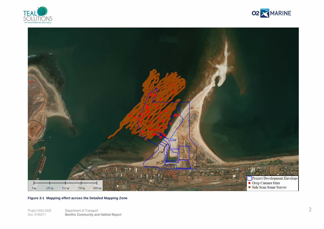
Figure 3-1 Mapping effort across the Detailed Mapping Zone 2
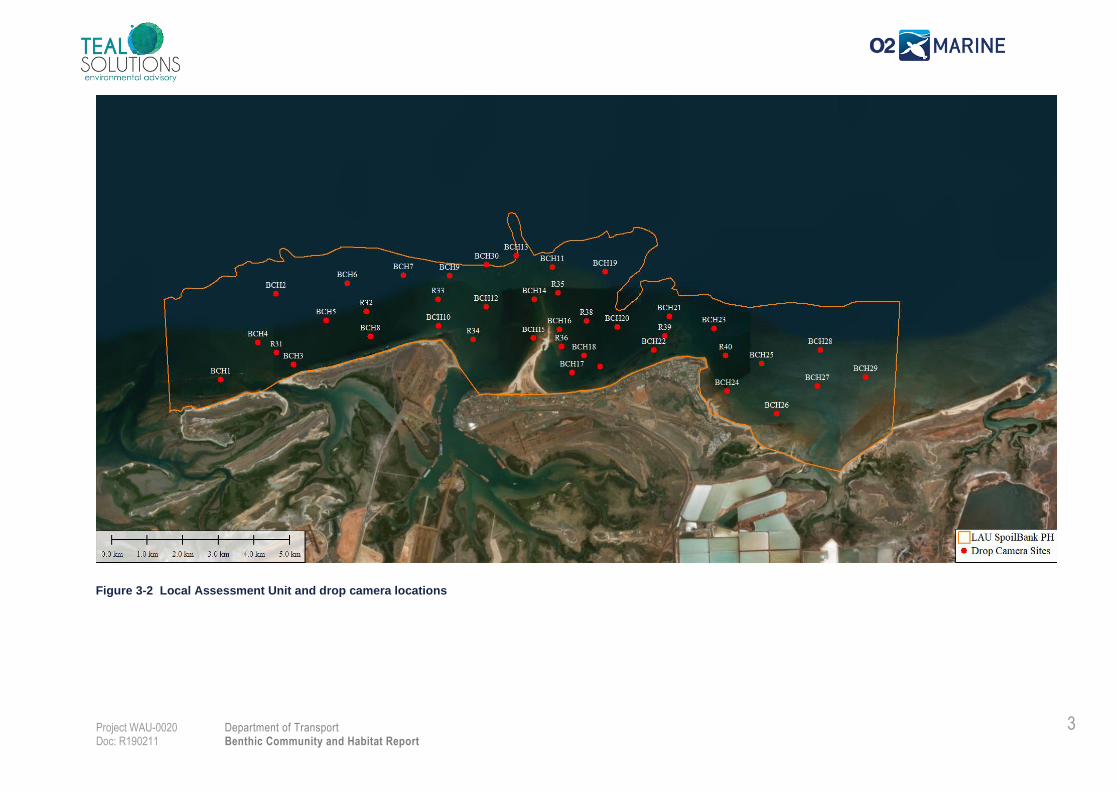
Figure 3-2 Local Assessment Unit and drop camera locations 3
Figure 3-3 Survey Equipment a) Spot X drop camera b) Starfish 450 Khz side scan sonar 5
Figure 4-1 BCH classified from drop camera within the Detailed Mapping Zone 8
Figure 4-2 BCH classified from drop camera within the LAU 9
Figure 4-3 Benthic habitats within the Detailed Mapping Zone 11
Figure 4-4 Benthic habitats across the LAU 12
Tables
Table 1-1 Summary of the Proposal 7
Table 4-1 BCH Classifications 6
Table 4-2 BCH Mapping Assumptions 10
Table 4-3 BCH coverage across the LAU 13
Appendices
Appendix A Benthic Communities and Habitat Survey Plan (O2M/Teal 2019) 19

1 Client Name Department of Transport
Project Name: Benthic Community and Habitat Report
Project WAU-0020 Doc: R190211
1. Introduction
Background
The Town of Port Hedland, together with LandCorp and the Pilbara Development Commission, are
planning for the development of a marina in Port Hedland. The Spoilbank Marina (the Marina) will be
located on the western side of the Spoilbank, adjacent to the Port Hedland Yacht Club and will include
a four-lane boat ramp, up to 80 boat pens and a ~1 km channel to provide access to the Port Hedland
Outer Channel (Figure 1-1).
The Department of Transport (DoT) are coordinating the design and environmental referral for the
proposed marina. Teal Solutions, together with O2 Marine (Teal/O2), have been engaged to undertake
the following work elements:
1. Sediment Quality Investigation;
2. Benthic Communities & Habitat (BCH) Survey (including cumulative loss assessment);
3. Prepare a Dredge and Disposal Management Plan; and
4. Develop a Marine Environmental Quality Plan.
These work elements will be used to assist the DoT prepare an environmental impact assessment and
project referral to the Environmental Protection Authority (EPA).
This document presents the results of the Benthic Communities and Habitat Survey.
1 Client Name Department of Transport
Project Name: Benthic Community and Habitat Report
Project WAU-0020 Doc: R190211
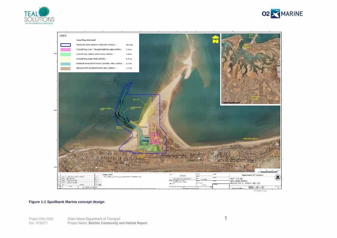
Project Description
The Port Hedland Spoilbank Marina development (the Marina) is located on Lot 5751 and Lot 5550 on
a site commonly known as the ‘Spoilbank’ (Town of Port Hedland 2019). The Spoilbank is an artificial
coastal landform created in the late-1960s/early-1970s from the disposal of material dredged from Port
Hedland’s inner harbour and shipping channel. The Project will replace the existing Richardson Street
boat ramp (which will be closed) and redirect boating activities away from the commercial operations of
Port Hedland’s inner harbour and navigation channel.
The Marina will include a four lane boat ramps, 80 boat pens, 208 trailers parking, 86 parking bays, dry
dock area for commercial vessels, public and pen holder amenities, public open space, and recreation
and event space (Town of Port Hedland 2019). The concept design is presented in Table 1-1 and
Figure 1-1.
Table 1-1 Summary of the Proposal
Port Hedland Spoilbank Marina
Proponent
Name
Department of Transport (WA)
Short
Description
Construction of the Port Hedland Spoilbank Marina includes the following works1:
• Dry-land excavation (332,000 m3) of the marina basin (5.7 ha) to a design depth -2 m CD (Chart
Datum)
• Dredging (108,500 m3) of access channel (2.75 ha) to a design depth of -2 m CD
• Dredging (217,000 m3) to -2 m CD to enable placement of footings for breakwaters and revetment wall
(4.5 ha) structures
• Excavation of sand trap (6.9 ha; 100,000 m3) to the north of the Marina entrance
• Construction of breakwaters and revetment walls (sourced from local quarries)
• Disposal of all dredge material to land adjacent to the Marina as fill material to raise the finished ground
level to +10 m CD prior to landscaping
Ongoing management and maintenance of the Marina will also be required.
1 The concept design for the Marina is still under development and these quantities are subject to change
1 Client Name Department of Transport
Project Name: Benthic Community and Habitat Report
Project WAU-0020 Doc: R190211
Figure 1-1 Spoilbank Marina concept design
1 Client Name Department of Transport
Project Name: Benthic Community and Habitat Report
Project WAU-0020 Doc: R190211
Scope and Objectives
This report presents a description of the subtidal Benthic Habitat Communities (BCH) of the project
area based on a desktop review and targeted site survey. The Report provides a basis for the BCH
cumulative loss assessment and includes:
Definition of the Local Assessment Unit (LAU)
Summary of field methods used for validation and ground truthing;
Characterisation of the subtidal BCH across the LAU;
Detailed BCH map of the area immediately adjacent to the proposed Marina; and
Review of any relevant tenure, conservation, ecological or social values relating to the BCH of
the project area.
Legislation and Guidelines
This study has been aligned with relevant state and federal legislation and technical guidance relevant
to BCH in the Project area, including:
Commonwealth Environmental Protection and Biodiversity Act 1999;
Western Australian Environmental Protection Act 1986 (EP Act);
Western Australian Biodiversity Conservation Act 2016; and
Western Australian Conservation and Land Management Act 1982.
The EPA provides guidance regarding the Environmental Impact Assessment process which includes
the definition of environmental principles, factors and associated objectives (Statement of
Environmental Principles, Factors and Objectives EPA 2018) as the basis for assessing whether a
proposal’s impact on the environment will be considered acceptable.
1.4.1. Environmental Principles
The object of the EP Act is to protect the environment of the State and identifies five environmental
Principles. The third Principle notes that ‘the conservation of biological diversity and ecological integrity
should be a fundamental consideration’ and this is directly relevant for the assessment of subtidal BCH
impacts.
1.4.2. Environmental Factors and Objectives
The EPA has defined 13 environmental factors which are separated into five themes: Sea, Land, Water,
Air and People. The environmental factors define those parts of the environment that may be impacted
by a proposal. For each environmental factor, the EPA defines an environmental objective and will
provide advice on whether these objectives may or may not be met for each factor when considering
the impacts of a proposal. The environmental factor for ‘benthic communities and habitats’ is a key
factor for the Marina proposal and the EPA’s objective for this factor is ‘to protect benthic communities
and habitats so that biological diversity and ecological integrity are maintained’. The EPA have issued
a number of guidelines relating to the consideration of BCH impacts, including:
1 Client Name Department of Transport
Project Name: Benthic Community and Habitat Report
Project WAU-0020 Doc: R190211
Technical Guidance – Protection of Benthic Communities and Habitats (EPA 2016a);
Environmental Factor Guideline – Benthic Communities and Habitats (EPA 2016b); and
Technical Guidance – Environmental Impact Assessment of Marine Dredging Proposals (EPA
2016c).
1.4.3. Local Assessment Unit (LAU)
The Local Assessment Unit (LAU) is the area within which to cumulative losses of Benthic Habitat
Communities are calculate in accordance with the EPA’s guidelines (EPA 2016b). The size and
dimensions of the LAU are determined on a case-by-case basis and should take into account aspects
of the local marine environment (EPA 2016a). A Project specific LAU was defined in accordance with
EPA guidance to assess the loss of BCH as part of the Benthic Communities and Habitat Survey Plan
(O2M/Teal 2019) provided in Appendix A.
1 Client Name Department of Transport
Project Name: Benthic Community and Habitat Report
Project WAU-0020 Doc: R190211
2. Existing Environment
Overview
Port Hedland is located on the Northwest Shelf of Australia approximately 190 km east-northeast of
Karratha and 460 km Southwest of Broome. Port Hedland is in the North-West Shelf marine region
and around the midpoint of the Pilbara coast (BHP 2011). The marine environment is connected to the
wider Indo-Pacific biogeographic region through the Leeuwin and Holloway Currents (BHP 2011). The
nearshore and inshore environments are characterised by low relief, medium to coarse-grained shell
fragments, strong tidal currents and turbid waters. Exposed limestone outcrops have resulted in the
development of protected embayments, wide salt flats and several offshore islands with associated reef
communities. The closest marine conservation areas are the Rowley Shoals Marine Park (300 km
offshore to the north) and Eighty Mile Beach Marine Park (100 km east).
Climate and Oceanography
The Wet Season (October to April) very hot, with average monthly maximum temperature of 36.1°C
(Bureau of Meteorology, 2019). During the Dry Season (May to September) the average monthly
maximum temperature is 28.8°C. North-westerly winds prevail during the Wet Season and a strong
south-easterly wind regime dominates during the Dry Season. The mean annual rainfall is 318 mm of
which 79% falls during the Wet Season and is typically associated with scattered thunderstorms
frequent cyclone events, including moderate to severe events every 5 to 10 years which cause extreme
event winds, waves, water levels, currents and sediment transport that can be significantly higher than
during ambient conditions (Baird 2019).
The passage of thunderstorms can also result in water level surges and localised flooding. The Pilbara
coastline is also the most cyclone-prone area within Australia. Since 1910, Port Hedland has been
impacted by 49 cyclones which are often associated with elevated water levels, high wave energy and
widespread flooding (BOM 2019a). The nearshore waters of Port Hedland range in temperature from
~30.1°C (in March) to ~23.2°C (in August) and generally have a low nutrient level (Seatemperature.org
2019).
Port Hedland experiences large, semi-diurnal tides with a Spring tide range of 7.9 m and a Neap tide
range of 1.5 m. Flood tide currents have a maximum speed of 1.5 kn and flow in an easterly direction,
ebb tides are directed to the north-west (PPA 2019).
Geomorphology
The Pilbara coast has a relatively wide continental shelf with a low relief slope between the shoreline
and the edge of the shelf approximately 200 km offshore which has a water depth of ~150 m (RPS 2014
and Jones 1973). Across the coastal platform shallow sandbars, platforms, reefs and ridges are
common. Occasional flooding causes the erosion and the dispersal of terrestrial sediment across the
nearshore and the development of silty tidal flats (RPS Cooke Point Prelim Assessment).
1 Client Name Department of Transport
Project Name: Benthic Community and Habitat Report
Project WAU-0020 Doc: R190211
Marine Water Quality
Waters within Port Hedland harbour and nearshore are typically well mixed (Halpern Glick Maunsell
1997). Substantial variation in water quality within the Harbour can occur following rainfall events and
inflow from five shallow creek systems which discharge into the harbour (BHP 2011).
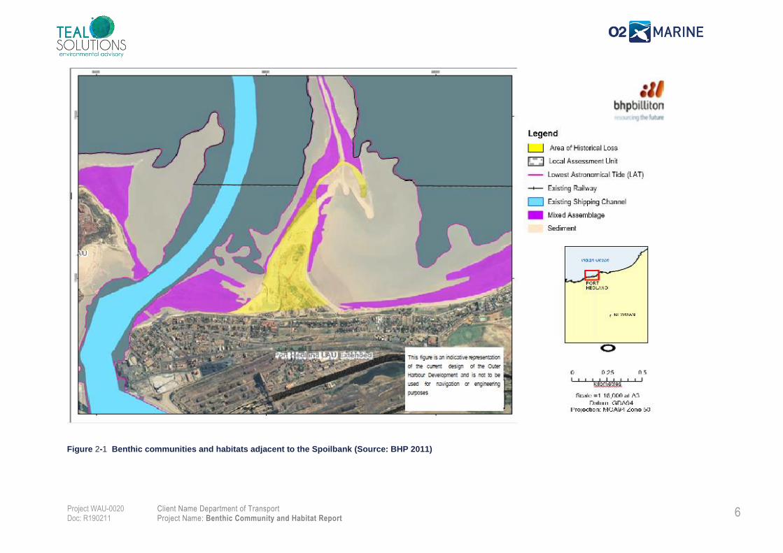
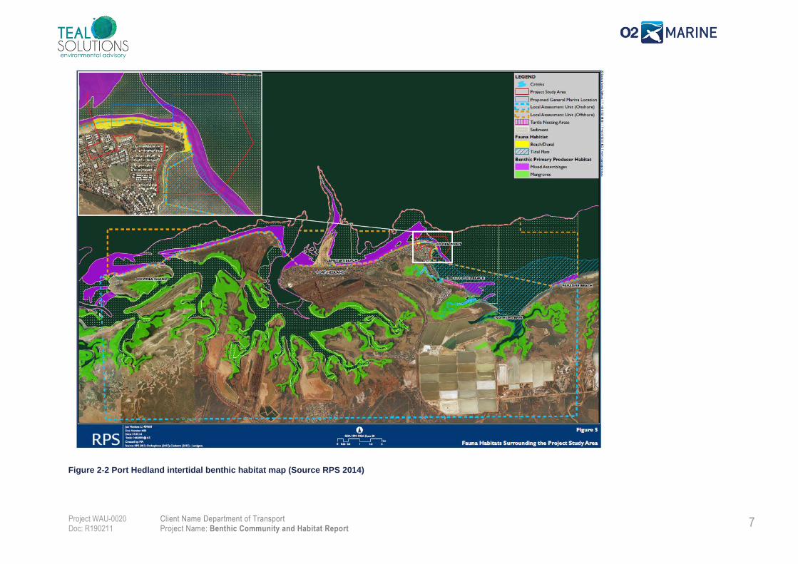
Benthic Communities and Habitats
Subtidal reef areas occur along the Port Hedland shoreline and are typically associated with low rocky
cliffs and sandy beaches with rocky intertidal platforms. The low-profile reef areas support a mixed
benthic community including hard corals, macroalgae, soft corals and other sessile filter feeding
organisms classified in previous habitat mapping studies as mixed assemblage habitats (Figure 2-1
and Figure 2-2). The diversity and abundance of biota in these habitats is highly variable as these areas
are occasional covered by sand due to seasonal changes in the metocean conditions and intermittent
storm and cyclone events (BHP 2011).
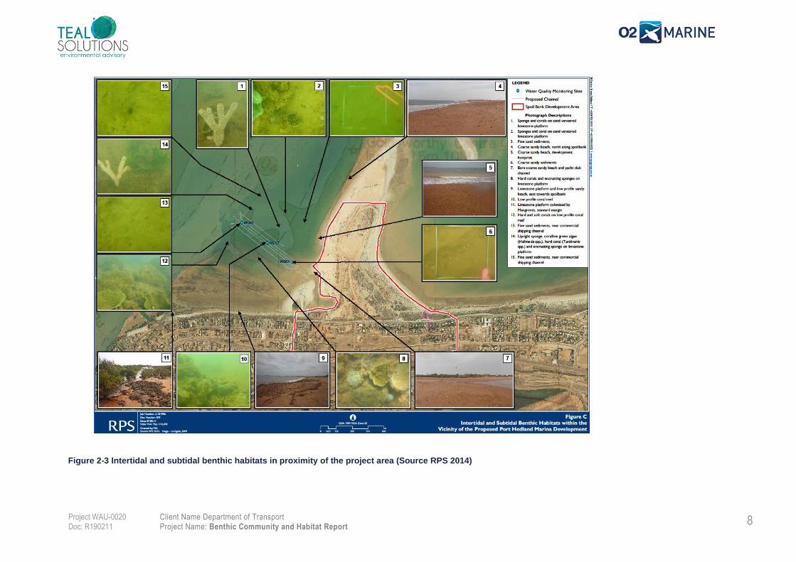
The areas surrounding the Spoilbank is characterised by low profile reefs supporting hard coral,
macroalgae and sponges, patches of very sparse sponges are also found on bare sediment substrate
within the subtidal zone whereas the intertidal zone is manly composed of bare sediment or bare
limestone (Figure 2-3).
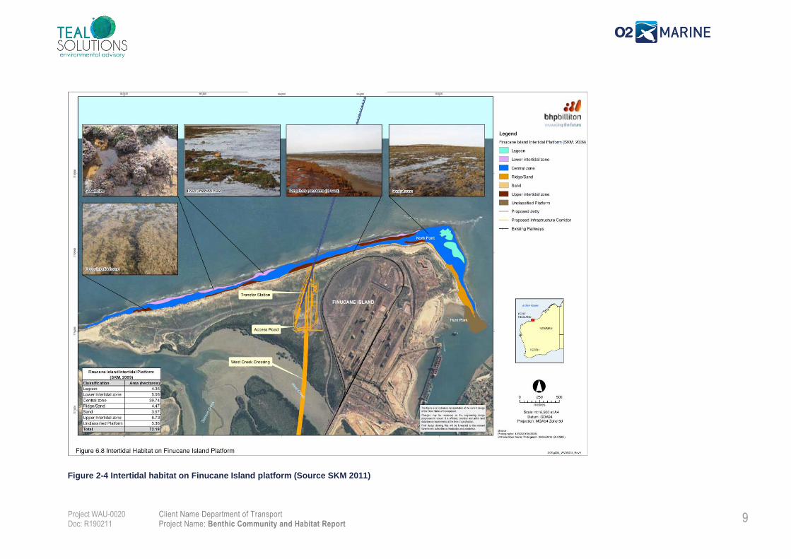
The intertidal communities adjacent to Finucane Island predominantly composed of macroalgae and
corals, with coral cover ~10% typically dominated by large bombies of Porites spp. with surrounding
smaller colonies Dendrophyllidae and Faviidae corals (URS 2005, SKM 2011) (Figure 2-4). These
shore-attached platforms are common in the nearshore area and support a range of biotic assemblages
with different species distributions depending on the water depth across the intertidal zone (BHP 2011):
• Lower Intertidal — Mixed benthic primary producers (mainly macroalgae and hard corals) and
other benthic invertebrates including echinoderms, molluscs and polychaetes. Serpulid worm casings
are often prominent.
• Central Zone — Macroalgae (Caulerpa, Halimeda, Neomeris & Sargassam spp.) in submerged
rock pools.
• Upper Intertidal— Predominantly turf algae on the flats and macroalgae in rivulets running
perpendicular to the shoreline.
Seagrass patches from the nearshore have been recorded east of Cooke Point and north of Finucane
Island. Seagrass in these areas are very sparse and comprised of only one species: Halodule uninervis
(Worley Parsons 2012).
.
6 Client Name Department of Transport Project Name: Benthic Community and Habitat Report
Project WAU-0020 Doc: R190211
Figure 2-1 Benthic communities and habitats adjacent to the Spoilbank (Source: BHP 2011)
7 Client Name Department of Transport Project Name: Benthic Community and Habitat Report
Project WAU-0020 Doc: R190211
Figure 2-2 Port Hedland intertidal benthic habitat map (Source RPS 2014)
8 Client Name Department of Transport Project Name: Benthic Community and Habitat Report
Project WAU-0020 Doc: R190211
Figure 2-3 Intertidal and subtidal benthic habitats in proximity of the project area (Source RPS 2014)
9 Client Name Department of Transport Project Name: Benthic Community and Habitat Report
Project WAU-0020 Doc: R190211
Figure 2-4 Intertidal habitat on Finucane Island platform (Source SKM 2011)
8 Client Name Department of Transport
Project Name: Benthic Community and Habitat Report
Project WAU-0020 Doc: R190211
3. Methods
Study Area
The benthic habitat mapping survey was undertaken across two areas: 1) Detailed Mapping Zone
immediately adjacent to the proposed Spoilbank Marina (Figure 3-1); and 2) Local Assessment Unit
(LAU) where broadscale groundtruthing was undertaken to validate the existing mapping (Figure 3-2).
The Detailed Mapping Zone is located immediately adjacent to the site of the proposed Marina and
entrance channel and has an area of 115 ha (Figure 3-1). Mapping in this area was undertaken using
a combination of side scan sonar and drop camera. This was supplemented with diver observations
obtained during the sediment sampling survey2.
Mapping across the Local Assessment Unite was based on a desktop review of previous habitat
mapping which was groundtruthed with drop camera footage at 40 locations: 30 chosen to confirm the
existing BCH classes, and 10 chosen at random locations across the LAU (these sites are labelled with
‘R’) (Figure 3-2).
2 The sediment sampling survey is documented in a separate report
2 Department of Transport
Benthic Community and Habitat Report
Project WAU-0020 Doc: R190211
Figure 3-1 Mapping effort across the Detailed Mapping Zone
3 Department of Transport
Benthic Community and Habitat Report
Project WAU-0020 Doc: R190211
Figure 3-2 Local Assessment Unit and drop camera locations
4
Client Name Department of Transport Project Name: Benthic Community and Habitat Report
Project WAU-0020 Doc: R190211
Field Survey
The field survey was conducted from 23 to 30 September 2019 by qualified and experienced
marine scientists from O2 Marine.
3.2.1. Drop Camera Survey
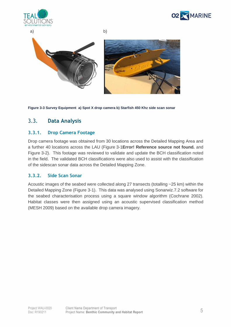
A Spot X Pro Squid camera system with real-time video streaming was used to record the
drop camera footage(Figure 3-3a). At each location the seabed was surveyed until the benthic
habitat could be determined with confidence. All footage was recorded to a mini SD card that
was backed-up to a computer daily. At each drop camera location, the following data was
manually recorded: coordinates (using Garmin GPSMAP 60CSx Handheld GPS Navigator
time, water depth and any incidental observations.
Two primary benthic habitat types (mixed assemblage and bare sand) were defined for the
classification of the drop camera footage to enable comparison to previous studies in the area
(BHP 2011 and RPS 2014d). The mixed assemblage habitat included macroalgae, sponges
and hard and soft corals. However, during the field survey several areas with ephemeral
seagrass were observed and a new category of ‘mixed assemblage with seagrass’ was
defined. The benthic habitat classifications for each drop camera site were entered directly
into the Global Mapper V12 GIS in the field.
3.2.2. Side Scan Sonar Survey
The side scan sonar survey was undertaken using a dual channel 450 kHz Tritech Starfish
452F system (Figure 3-3b). This unit was operated through a topside control unit coupled to
Scanline V2.1 acquisition software. Geographic positioning of the side scan sonar data was
acquired using a Starfish GPS with an accuracy of ±2 m (GPS/NAVISTAR 2008). The side
scan sonar was towed behind the vessel at a speed of ~4 kn and captured a swath width of
four to five times the water depth. Coverage of the Detailed Mapping Zone was completed
using series of parallel transects spaced ~40 m apart (Figure 3-1). The side scan sonar
enables the capture of backscatter data which was groundtruthed using drop camera footing
to validate the benthic features identified.
5
Client Name Department of Transport Project Name: Benthic Community and Habitat Report
Project WAU-0020 Doc: R190211
a)
b)
Figure 3-3 Survey Equipment a) Spot X drop camera b) Starfish 450 Khz side scan sonar
Data Analysis
3.3.1. Drop Camera Footage
Drop camera footage was obtained from 30 locations across the Detailed Mapping Area and
a further 40 locations across the LAU (Figure 3-1Error! Reference source not found. and
Figure 3-2). This footage was reviewed to validate and update the BCH classification noted
in the field. The validated BCH classifications were also used to assist with the classification
of the sidescan sonar data across the Detailed Mapping Zone.
3.3.2. Side Scan Sonar
Acoustic images of the seabed were collected along 27 transects (totalling ~25 km) within the
Detailed Mapping Zone (Figure 3-1). This data was analysed using Sonarwiz.7.2 software for
the seabed characterisation process using a square window algorithm (Cochrane 2002).
Habitat classes were then assigned using an acoustic supervised classification method
(MESH 2009) based on the available drop camera imagery.
6
Client Name Department of Transport Project Name: Benthic Community and Habitat Report
Project WAU-0020 Doc: R190211
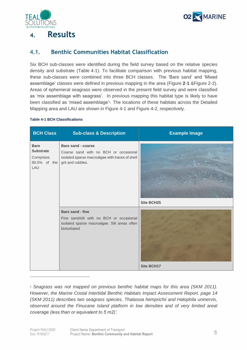
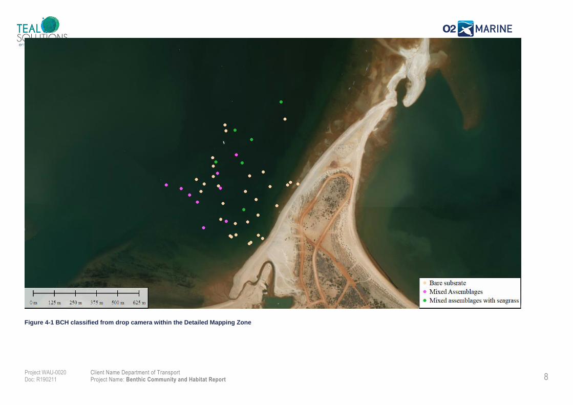
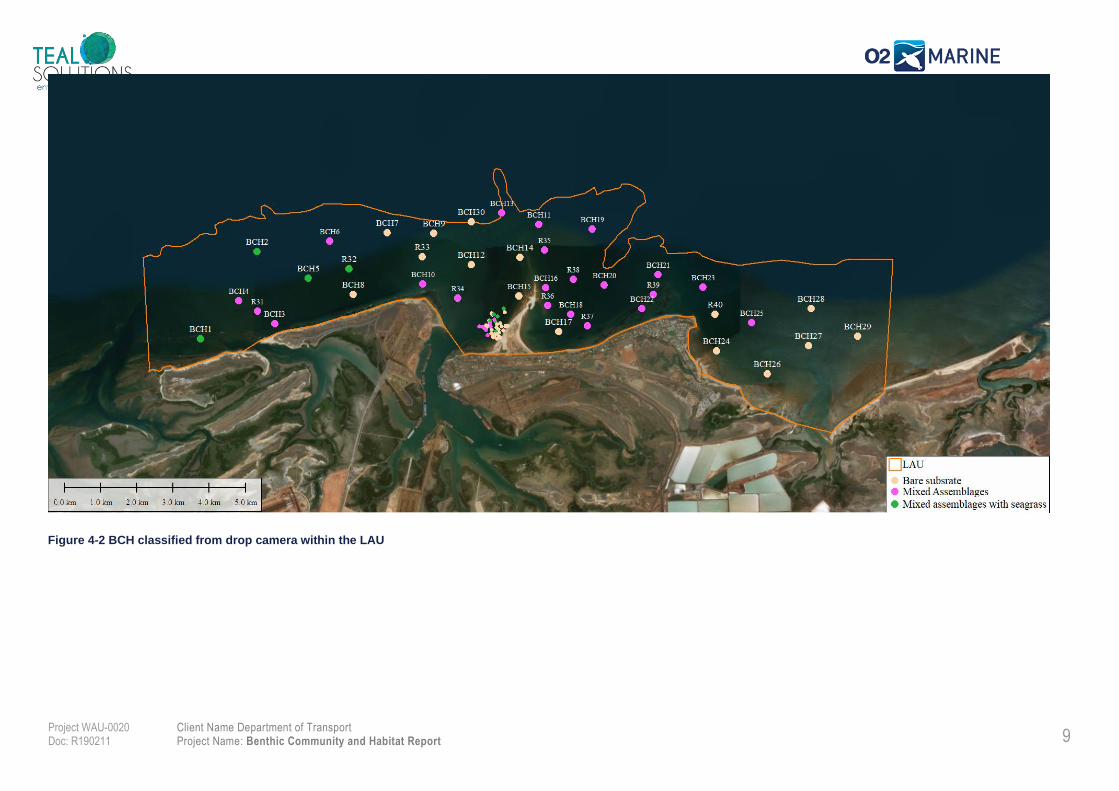
4. Results
Benthic Communities Habitat Classification
Six BCH sub-classes were identified during the field survey based on the relative species
density and substrate (Table 4-1). To facilitate comparison with previous habitat mapping,
these sub-classes were combined into three BCH classes. The ‘Bare sand’ and ‘Mixed
assemblage’ classes were defined in previous mapping in the area (Figure 2-1 &Figure 2-2).
Areas of ephemeral seagrass were observed in the present field survey and were classified
as ‘mix assemblage with seagrass’. In previous mapping this habitat type is likely to have
been classified as ‘mixed assemblage’3. The locations of these habitats across the Detailed
Mapping area and LAU are shown in Figure 4-1 and Figure 4-2, respectively.
Table 4-1 BCH Classifications
BCH Class Sub-class & Description Example Image
Bare
Substrate
Comprises
90.5% of the
LAU
Bare sand - coarse
Coarse sand with no BCH or occasional
isolated sparse macroalgae with traces of shell
grit and rubbles.
Site BCH25
Bare sand - fine
Fine sand/silt with no BCH or occasional
isolated sparse macroalgae. Silt areas often
bioturbated
Site BCH17
3 Seagrass was not mapped on previous benthic habitat maps for this area (SKM 2011).
However, the Marine Costal Intertidal Benthic Habitats Impact Assessment Report, page 14
(SKM 2011) describes two seagrass species, Thalassia hemprichii and Halophila uninervis,
observed around the Finucane Island platform in low densities and of very limited areal
coverage (less than or equivalent to 5 m2)’.
7
Client Name Department of Transport Project Name: Benthic Community and Habitat Report
Project WAU-0020 Doc: R190211
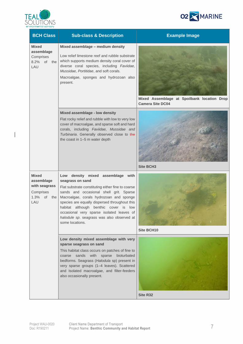
BCH Class Sub-class & Description Example Image
Mixed
assemblage
Comprises
8.2% of the
LAU
Mixed assemblage – medium density
Low relief limestone reef and rubble substrate
which supports medium density coral cover of
diverse coral species, including Faviidae,
Mussidae, Portitidae, and soft corals.
Macroalgae, sponges and hydrozoan also
present.
Mixed Assemblage at Spoilbank location Drop
Camera Site DC04
Mixed assemblage - low density
Flat rocky relief and rubble with low to very low
cover of macroalgae, and sparse soft and hard
corals, including Faviidae, Mussidae and
Turbinaria. Generally observed close to the
the coast in 1–5 m water depth
Site BCH3
Mixed
assemblage
with seagrass
Comprises
1.3% of the
LAU
Low density mixed assemblage with
seagrass on sand
Flat substrate constituting either fine to coarse
sands and occasional shell grit. Sparse
Macroalgae, corals hydrozoan and sponge
species are equally dispersed throughout this
habitat although benthic cover is low
occasional very sparse isolated leaves of
halodule sp. seagrass was also observed at
some locations.
Site BCH10
Low density mixed assemblage with very
sparse seagrass on sand
This habitat class occurs on patches of fine to
coarse sands with sparse bioturbated
bedforms. Seagrass (Halodula sp) present in
very sparse groups (1–4 leaves). Scattered
and Isolated macroalgae, and filter-feeders
also occasionally present.
Site R32
8
Client Name Department of Transport Project Name: Benthic Community and Habitat Report
Project WAU-0020 Doc: R190211
Figure 4-1 BCH classified from drop camera within the Detailed Mapping Zone
9
Client Name Department of Transport Project Name: Benthic Community and Habitat Report
Project WAU-0020 Doc: R190211
Figure 4-2 BCH classified from drop camera within the LAU
10
Client Name Department of Transport Project Name: Benthic Community and Habitat Report
Project WAU-0020 Doc: R190211
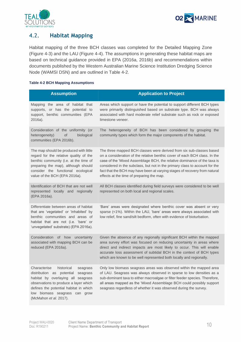
Habitat Mapping
Habitat mapping of the three BCH classes was completed for the Detailed Mapping Zone
(Figure 4-3) and the LAU (Figure 4-4). The assumptions in generating these habitat maps are
based on technical guidance provided in EPA (2016a, 2016b) and recommendations within
documents published by the Western Australian Marine Science Institution Dredging Science
Node (WAMSI DSN) and are outlined in Table 4-2.
Table 4-2 BCH Mapping Assumptions
Assumption Application to Project
Mapping the area of habitat that
supports, or has the potential to
support, benthic communities (EPA
2016a).
Areas which support or have the potential to support different BCH types
were primarily distinguished based on substrate type. BCH was always
associated with hard moderate relief substrate such as rock or exposed
limestone veneer.
Consideration of the uniformity (or
heterogeneity) of biological
communities (EPA 2016b).
The heterogeneity of BCH has been considered by grouping the
community types which form the major components of the habitat.
The map should be produced with little
regard for the relative quality of the
benthic community (i.e. at the time of
preparing the map), although should
consider the functional ecological
value of the BCH (EPA 2016a).
The three mapped BCH classes were derived from six sub-classes based
on a consideration of the relative benthic cover of each BCH class. In the
case of the ‘Mixed Assemblage BCH, the relative dominance of the taxa is
considered in the subclass, but not in the primary class to account for the
fact that the BCH may have been at varying stages of recovery from natural
effects at the time of preparing the map.
Identification of BCH that are not well
represented locally and regionally
(EPA 2016a).
All BCH classes identified during field surveys were considered to be well
represented on both local and regional scales.
Differentiate between areas of habitat
that are ‘vegetated’ or ‘inhabited’ by
benthic communities and areas of
habitat that are not (i.e. ‘bare’ or
‘unvegetated’ substrate) (EPA 2016a).
‘Bare’ areas were designated where benthic cover was absent or very
sparse (<1%). Within the LAU, ‘bare’ areas were always associated with
low relief, fine sand/silt bedform, often with evidence of bioturbation.
Consideration of how uncertainty
associated with mapping BCH can be
reduced (EPA 2016a).
Given the absence of any regionally significant BCH within the mapped
area survey effort was focused on reducing uncertainty in areas where
direct and indirect impacts are most likely to occur. This will enable
accurate loss assessment of subtidal BCH in the context of BCH types
which are known to be well represented both locally and regionally.
Characterise historical seagrass
distribution as potential seagrass
habitat by overlaying all seagrass
observations to produce a layer which
defines the potential habitat in which
low biomass seagrass can grow
(McMahon et al. 2017).
Only low biomass seagrass areas was observed within the mapped area
of LAU. Seagrass was always observed in sparse to low densities as a
sub-dominant taxa to either macroalgae or filter feeder species. Therefore,
all areas mapped as the ‘Mixed Assemblage BCH could possibly support
seagrass regardless of whether it was observed during the survey.
11
Client Name Department of Transport Project Name: Benthic Community and Habitat Report
Project WAU-0020 Doc: R190211
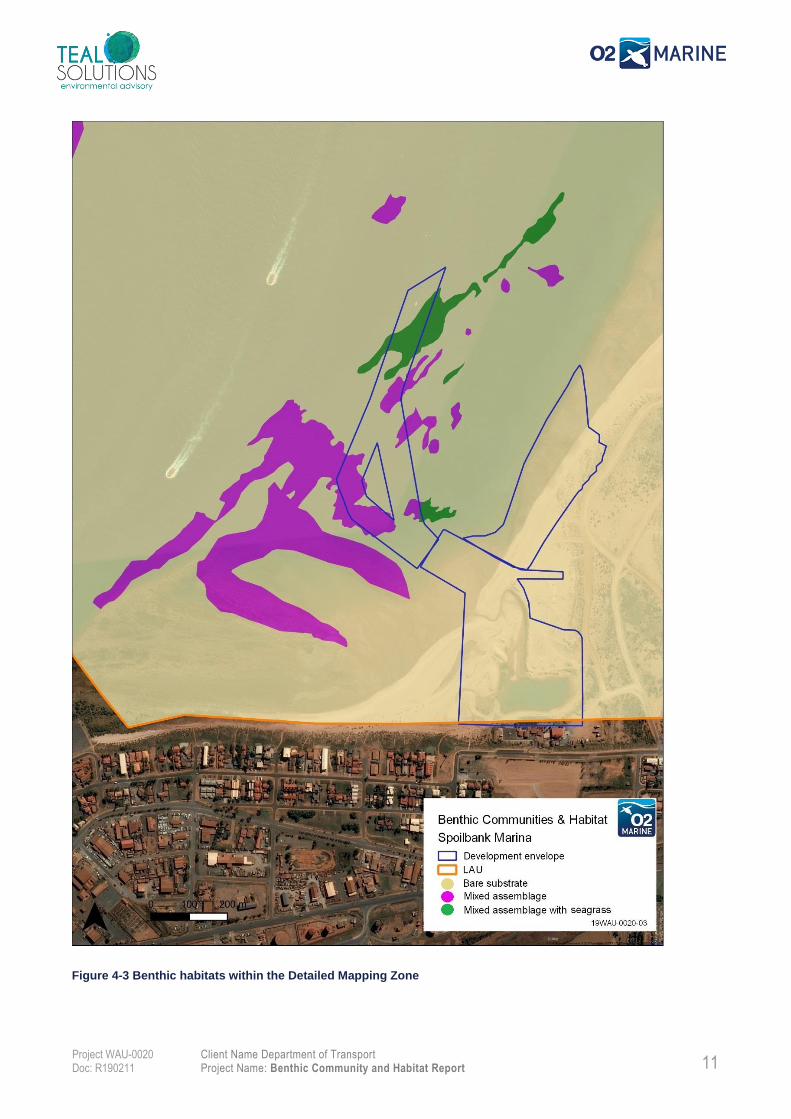
Figure 4-3 Benthic habitats within the Detailed Mapping Zone
12
Client Name Department of Transport Project Name: Benthic Community and Habitat Report
Project WAU-0020 Doc: R190211
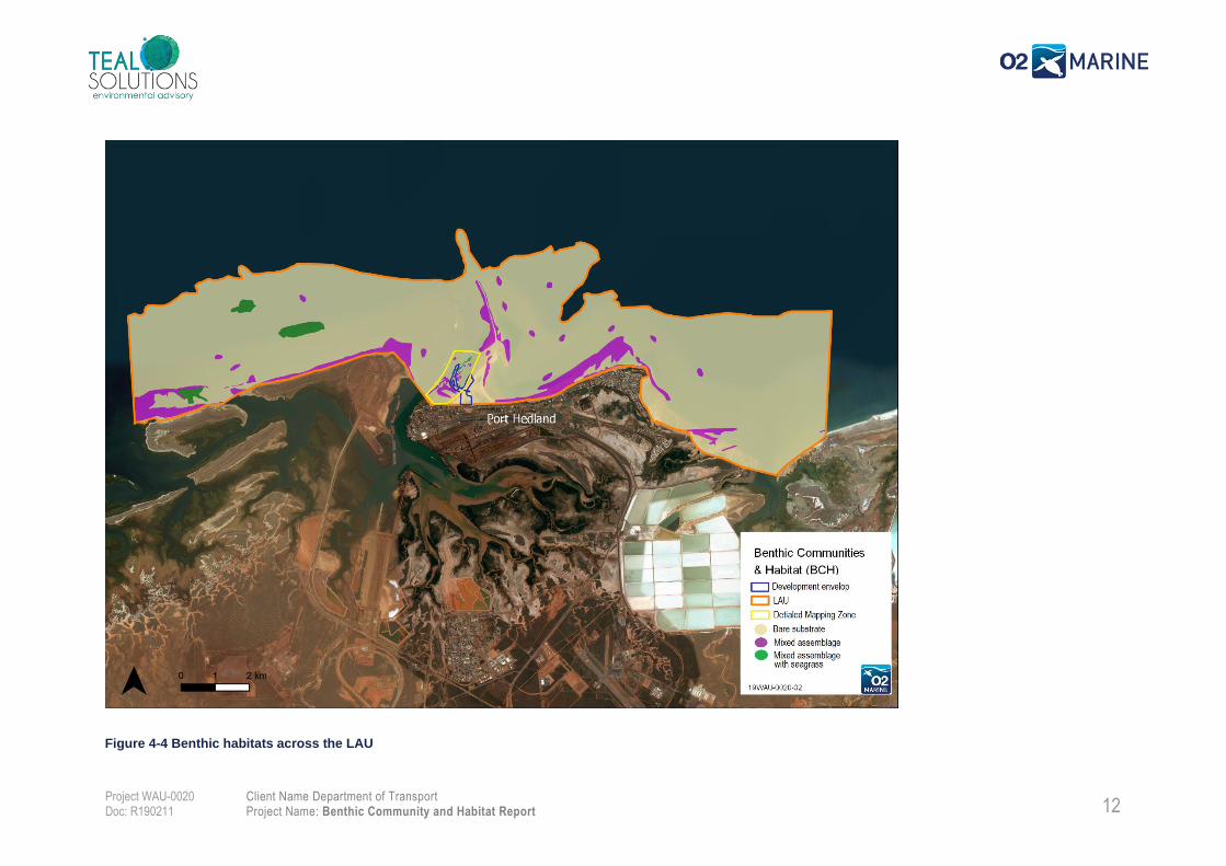
Figure 4-4 Benthic habitats across the LAU
35 Client Name Department of Transport Project Name: Benthic Community and Habitat Report
Project WAU-0020 Doc: R190211
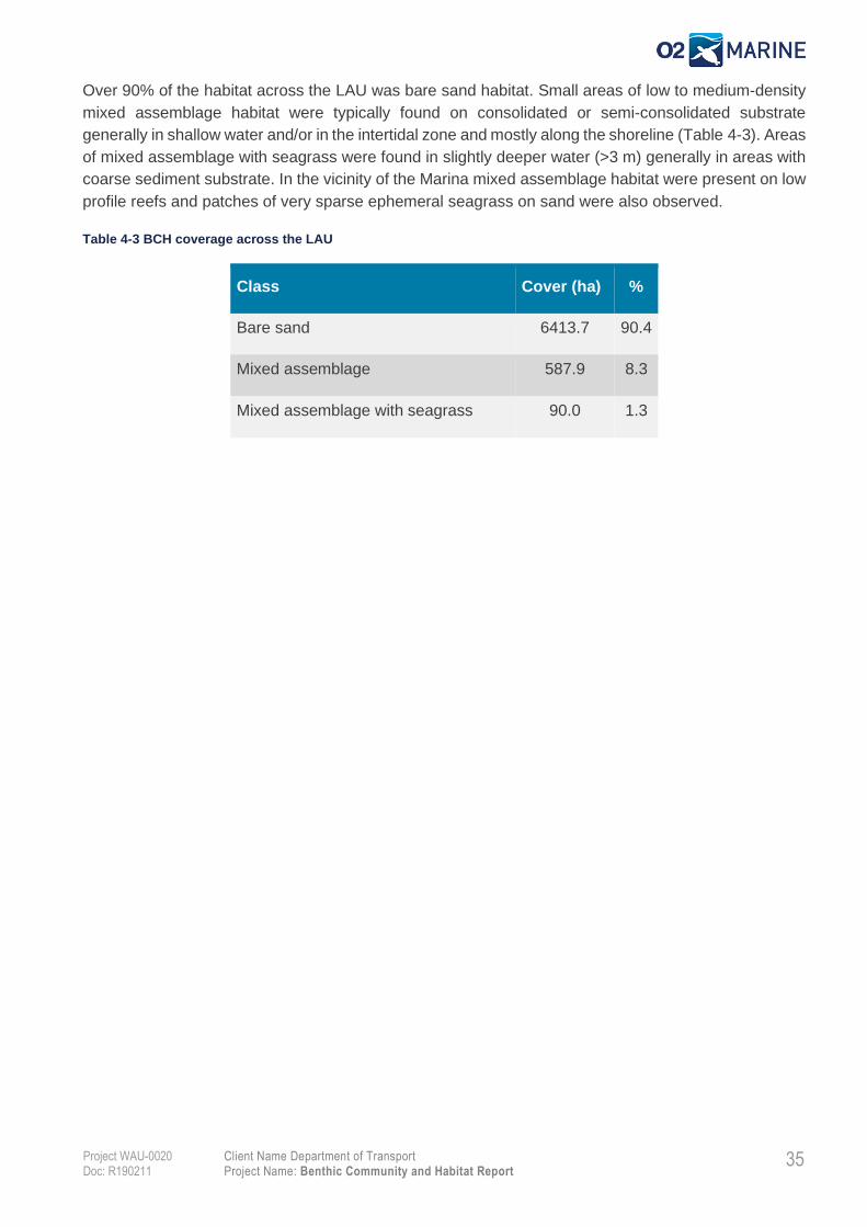
Over 90% of the habitat across the LAU was bare sand habitat. Small areas of low to medium-density
mixed assemblage habitat were typically found on consolidated or semi-consolidated substrate
generally in shallow water and/or in the intertidal zone and mostly along the shoreline (Table 4-3). Areas
of mixed assemblage with seagrass were found in slightly deeper water (>3 m) generally in areas with
coarse sediment substrate. In the vicinity of the Marina mixed assemblage habitat were present on low
profile reefs and patches of very sparse ephemeral seagrass on sand were also observed.
Table 4-3 BCH coverage across the LAU
Class Cover (ha) %
Bare sand 6413.7 90.4
Mixed assemblage 587.9 8.3
Mixed assemblage with seagrass 90.0 1.3
35 Client Name Department of Transport Project Name: Benthic Community and Habitat Report
Project WAU-0020 Doc: R190211
5. Functional Ecological Value
The functional ecological value of the three benthic habitats are described below.
Bare Sand
The bare sand habitat can support microphytobenthic algal communities and benthic infauna. It is also
likely that some areas of bare or unvegetated substrate will support more complex ephemeral BCH at
different times, particularly in shallow water areas where the benthos is constantly changing in response
to physical disturbance from wave mobilisation of sediments, storm events and sedimentation following
large runoff events.
Mixed Assemblage
The mixed assemblage benthic habitat includes corals, macroalgae, sponges and other species of filter-
feeders present with different percentage coverage. Corals are particularly important as benthic primary
producer, providing habitat and a food source for a wide variety of marine species (Moberg and Folke
1999), moreover corals perform an important role as nutrient recycler. The associated macroalgae are
also an important component of tropical reef ecosystems as they contribute to the productivity of a
system as a food source, provide habitat for a range of economically and ecologically important species,
contribute to local sediments and play an important role in the nutrient cycle from decomposition
(Kendrick & Olsen 2017). The mixed assemblage habitat were found predominantly on hard substrate
along the shoreline and represented less than 9% of the LAU and generally had a low level of
biodiversity. Therefore the likely contribution of these coral communities to local and regional
ecosystem is considered to be limited.
Mixed assemblage with seagrass
The mixed assemblage with seagrass benthic habitat includes mixed communities with sparse
seagrass mixed at corals, macroalgae and other filter feeders, as well as sparse to very sparse
seagrass on bare sand substrate. Seagrasses are known to provide an important role within the marine
ecosystem providing carbon storage, filtering nutrients and particles from the water column, stabilising
sediments and providing high primary productivity (McKenzie et al. 2006). Seagrass can also provide
an important source of foraging habitat for dugong, turtles and commercially fisheries, such as prawns.
However, the limited distribution and low cover of seagrasses observed within the LAU suggests that
their contribution to ecosystem services in a regional context is limited.
35 Client Name Department of Transport Project Name: Benthic Community and Habitat Report
Project WAU-0020 Doc: R190211
6. Conservation and Social Value
The proposed Marina will be located in State Waters within the harbour limits of the Port Hedland port.
The conservation of ecologically significant marine, estuarine or terrestrial ecosystems is managed
through the Conservation and Land Management Act. The subtidal habitats within the Project area have
not been identified as containing significant ecological communities requiring protection through the
introduction of marine conservation reserves. The nearest Marine Park is the Eighty Mile Beach Marine
Park, which is located ~ 100 km east of Port Hedland. No Listed Threatened Ecological Communities
are known to occur within the LAU.
35 Client Name Department of Transport Project Name: Benthic Community and Habitat Report
Project WAU-0020 Doc: R190211
7. Conclusions
Three benthic habitats were observed in the vicinity of the Project area:
• Bare Sand;
• Mixed assemblage; and
• Mixed assemblage with seagrass.
The benthic cover was generally sparse to low across more than 95% of the study area. All habitats
identified within LAU are considered to be widespread across the turbid nearshore environments of the
Pilbara region and as such do not represent habitats of particular regional or conservation significance.
Sparse seagrass communities were observed in the vicinity of the Project area, and in the LAU to the
west. Corals were also observed in proximity of the project area.
35 Client Name Department of Transport Project Name: Benthic Community and Habitat Report
Project WAU-0020 Doc: R190211
8. References
BHP Billiton. 2011. Proposed Outer Harbour Development, Port Hedland: Public Environmental Review
/ Draft Environmental Impact Statement. Perth: Western Australia.
Bureau of Meterology (BOM). 2019. Climate Statistics for Port Hedland. Accessed on 10th of October
2019. http://www.bom.gov.au/climate/averages/tables/cw_004032.shtml
Bureau of Meterology (BOM). 2019a. Tropical Cyclones Affecting Port Hedland. Accessed on 10th of
October 2019. http://www.bom.gov.au/cyclone/history/wa/pthed.shtml
Cardno. 2011. Port Hedland Coastal Vulnerability Study. Perth: Western Australia.
Cochrane, G.R., & Lafferty, K.D., 2002. Use of acoustic classification of sidescan sonar data for
mapping benthic habitat in the Northern Channel Islands, California. Continental Shelf Research 22,
683-690.
Department of Environment 2006. Pilbara Coastal Water Quality Consultation Outcomes —
Environmental Values and Environmental Quality Objectives, Department of Environment, Government
of Western Australia, Marine Series Report No. 1.
Eliot I, Gozzard B, Eliot M, Stul T and McCormack G. 2013. Geology, Geomorphology & Vulnerability
of the Pilbara Coast, In the Shires of Ashburton, East Pilbara and Roebourne, and the Town of Port
Hedland, Western Australia. Damara WA Pty Ltd and Geological Survey of Western Australia, Innaloo,
Western Australia.
EPA 2009. Environmental Assessment Guidelines No. 3: Protection of Environmental Factors Benthic
Primary Producer Habitats in Western Australia’s Marine Environment. Environmental Protection
Authority, Perth, Western Australia.
Global Positioning System (GPS) 2008. Global Positioning System Standard Positioning Service
Performance Standard , 4th Edition September 2008
Jones, H.A., 1973. Marine geology of the northwest Australian continental shelf. Bur. Min.Res. Geol.
Geophys., Bull., 136, 102pp.
Kendrick, G and Olsen, Y. 2017. Characterising macroalgal communities of the Pilbara. Macrophyte
interactions. CSIRO.
McKenzie, L.J., Erftemeijer, P and Coles, R. 2006. Seagrass ecosystems of Papua.The Ecology of
Papua (Volume I & II), Chapter:5.3 (Voll II). Periplus Editions (Singapore), pp. 800-823. Research Gate,
https://www. reaserchgate.net/publication/283043957
Moberg, F and Folke, F. 1999. Ecological goods and services of coral reef ecosystems. Ecological
Economics 29: 215-233.
O2 Marine/Teal 2019. Port Hedland Spoilbank Marina: Benthic Communities and Habitat Survey Plan.
Report prepared for Department of Transport.
35 Client Name Department of Transport Project Name: Benthic Community and Habitat Report
Project WAU-0020 Doc: R190211
Pilbara Ports Authority. 2019. Weather and Tides. Accessed 10th of October 2019.
https://www.pilbaraports.com.au/Port-of-Port-Hedland/Port-operations/Weather-and-tides
RPS. 2014. Preliminary Environmental Assessment Report. Cooke Point Marina, Port Hedland. RPS
Environment and Planning
Seatemperature.org, 2019. Port Hedland average sea temperature
https://www.seatemperature.org/australia-pacific/australia/port-hedland.htm
SKM. 2011. Port Hedland Outer Harbour Development: Marine Costal Intertidal Benthic Habitats Impact
Assessment. Report prepared for BHP Billiton Iron Ore by Sinclair Knight Merz, Perth Western
Australia, April 2011.
SKM 2009. Port Hedland Outer Harbour Development: Spoil Ground Selection Study. Report prepared
for BHP Billiton Iron Ore by Sinclair Knight Merz, Perth Western Australia, July 2009.
Town of Port Hedland 2019. Draft Port Hedland Marina and Waterfront Masterplan. Town of Port
Hedland 1 November 2019.
URS 2005. Maintenance Dredging Campaign: Environmental Monitoring 2004. Prepared for Port
Hedland Port Authority
35 Client Name Department of Transport Project Name: Benthic Community and Habitat Report
Project WAU-0020 Doc: R190211
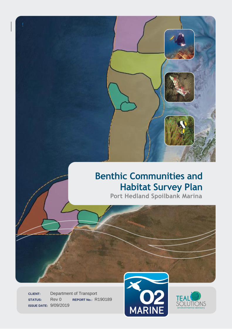
Appendix A Benthic Communities and Habitat Survey Plan (O2M/Teal 2019)
f
CLIENT: Department of Transport
STATUS: Rev 0 REPORT No.: R190189
ISSUE DATE: 9/09/2019
Benthic Communities and Habitat Survey Plan
Port Hedland Spoilbank Marina
ii Department of Transport
Benthic Communities and Habitat Survey Plan: Port Hedland Spoil Bank Marina
19WAU - 0020 / R190192
Important Note
This report and all its components (including images, audio, video, text) is copyright. Apart from fair
dealing for the purposes of private study, research, criticism or review as permitted under the Copyright
Act 1968, no part may be reproduced, copied, transmitted in any form or by any means (electronic,
mechanical or graphic) without the prior written permission of O2 Marine and Teal Solutions.
This report has been prepared for the sole use of the Department of Transport (herein, ‘the client’),
for a specific site (herein ‘the site’, the specific purpose specified in Section 1 of this report (herein ‘the
purpose’). This report is strictly limited for use by the client, to the purpose and site and may not be
used for any other purposes.
Third parties, excluding regulatory agencies assessing an application in relation to the purpose, may
not rely on this report. O2 Marine and Teal Solutions waive all liability to any third-party loss, damage,
liability or claim arising out of or incidental to a third-party publishing, using or relying on the facts,
content, opinions or subject matter contained in this report.
O2 Marine and Teal Solutions waive all responsibility for loss or damage where the accuracy and
effectiveness of information provided by the Client or other third parties was inaccurate or not up to date
and was relied upon, wholly or in part in reporting.
Report prepared on behalf of the Department of Transport by O2 Marine in
collaboration with Teal Solutions
iii Department of Transport
Benthic Communities and Habitat Survey Plan: Port Hedland Spoil Bank Marina
19WAU - 0020 / R190192
WA Marine Pty Ltd t/as O2 Marine ACN 168 014 819
Originating Office – Fremantle
11 Mews Road Fremantle WA 6160
T 1300 739 447 | [email protected]
Version Register
Version Status Author Reviewer Change from
Previous Version
Authorised for Release
(signed and dated)
Draft A J.Abbott C.Del Deo Minor Edits
Final 0 C.Del Deo
Bruce Hegge Bruce Hegge
Chris Lane
Transmission Register
Controlled copies of this document are issued to the persons/companies listed below. Any copy of this
report held by persons not listed in this register is deemed uncontrolled. Updated versions of this report
if issued will be released to all parties listed below via the email address listed.
Name Email Address
Bradford Jason [email protected]
Matthew Spence [email protected]

iv Department of Transport
Benthic Communities and Habitat Survey Plan: Port Hedland Spoil Bank Marina
19WAU - 0020 / R190192
Table of Contents
1. Introduction 5
Project Background 5
Objectives 6
2. Existing BCH Environment 7
Local Assessment Unit (LAU) 9
3. Survey Locations 14
4. Methods 15
Data Collection 15
Data Processing 18
5. Deliverables 19
6. Reference List 20
Figures
Figure 1-1 Proposed Spoilbank Marina Development in Port Hedland 5
Figure 2-1 Benthic habitats mapped as part of the Outer Harbour investigations (BHP 2011) 7
Figure 2-2 Benthic habitats mapped as part of the Port Hedland Marina investigations (SKM 2014d) 8
Figure 2-3 Distribution of subtidal and intertidal BPPH in the inner harbour of Port Hedland (Worley Parsons 2012b) 9
Figure 2-4 Local assessment unit (LAU) for the Port Hedland inner harbour specified in EPA guidelines (EPA, 2016)10
Figure 2-5 Local assessment unit used for the Outer Harbour Development (BHP 2011) 11
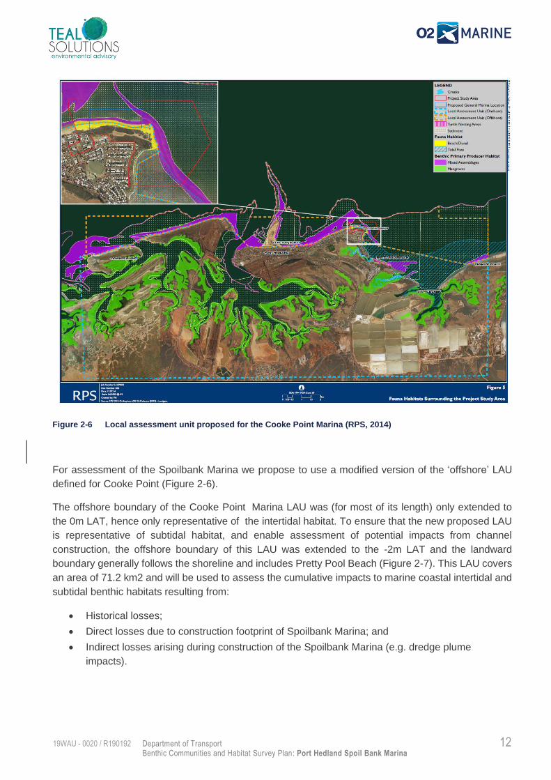
Figure 2-6 Local assessment unit proposed for the Cooke Point Marina (RPS, 2014) 12
Figure 2-7 Proposed Local Assessment Unit for the Spoilbank Marina 13
Figure 3-1 Notional boundary of detailed BCH mapping zone 14
Figure 4-1 Survey Equipment a) StarFish 450F b) Spot X drop camera 15
Figure 4-2 Proposed drop camera survey locations 17
Figure 4-3 Example of side scan data processing: (A) backscatter image of seabed B) classified acoustic image C) validation of target via drop camera) 18
Appendices
Appendix A Technical Specification - Starfish 452 Side Scan Sonar A
5 Department of Transport
Benthic Communities and Habitat Survey Plan: Port Hedland Spoil Bank Marina
19WAU - 0020 / R190192
1. Introduction
Project Background
The Town of Port Hedland, together with LandCorp and the Pilbara Development Commission, are
planning for the development of a marina in Port Hedland. A concept design has been developed for
the Spoilbank Marina, to be located on the western side of the Spoilbank, adjacent to the Port Hedland
Yacht Club (Figure 1-1). The Spoilbank Marina will include a four-lane boat ramp, up to 80 boat pens
and a ~1 km channel to provide access to the Port Hedland Outer Channel (Figure 1-1). The Project
will require dredging and onshore disposal of approximately 850,000 m3 of material.
Figure 1-1 Proposed Spoilbank Marina Development in Port Hedland
The Department of Transport (DoT) are coordinating the design and environmental approvals
application for the proposed marina. Teal Solutions, together with O2 Marine (Teal/O2), have been
engaged to undertake the following work elements:
1. Sediment Quality Investigation;
2. Benthic Communities & Habitat (BCH) Survey (including cumulative loss assessment);
3. Development of a Dredge and Disposal Management Plan; and
6 Department of Transport
Benthic Communities and Habitat Survey Plan: Port Hedland Spoil Bank Marina
19WAU - 0020 / R190192
4. Develop a Marine Environmental Quality Plan.
These work elements will be used to assist the DoT prepare an environmental impact assessment and
project referral to the Environmental Protection Authority (EPA).
The present document outlines the methods to be used to undertake the Benthic Communities and
Habitat Survey (including cumulative loss assessment).
Objectives
The objective of the Benthic Communities and Habitat Survey plan is to:
• Define the survey area that sufficiently represent the zone of potential impact for the
development;
• Characterise the Local Assessment Unit (LAU) via desktop review studies;
• Outline the methods and equipment used to undertake the field surveys to validate the BCH in
the LAU; and
• Outline the project deliverables for the BCH surveys.
7 Department of Transport
Benthic Communities and Habitat Survey Plan: Port Hedland Spoil Bank Marina
19WAU - 0020 / R190192
2. Existing BCH Environment
Benthic communities are biological communities that inhabit the seabed and are important for primary
or secondary production. Benthic habitats are areas of seabed that do or ‘can’ support these
communities. The term ‘seabed’, when used in the context of the definition for BCH above, includes
seabed substrates in the intertidal and subtidal zones of WA’s coastal waters.
Several previous studies have been undertaken for both the marine and terrestrial environments
associated with the proposed Port Hedland Marina which was to be located at the same site as the
Spoilbank Marina, including: acid sulfate soils (RPS, 2014a), soil and sediment contamination
assessment (RPS, 2014b), marine water quality (RPS, 2014c). Previous benthic habitat mapping
investigations show that the area adjacent to the proposed Spoilbank Marina consists of mixed
assemblage and bare sand (RPS, 2014d and BHP, 2011). The mixed assemblage included
macroalgae, sponges and hard and soft corals (Figure 2-1 and Figure 2-2). It should be noted that
while bare sand areas are relatively inconspicuous and lack three dimensional structure, they can be
significant contributors to overall benthic primary productivity, and can provide habitat for short range
endemic fauna (EPA 2016).
Figure 2-1 Benthic habitats mapped as part of the Outer Harbour investigations (BHP 2011)
8 Department of Transport
Benthic Communities and Habitat Survey Plan: Port Hedland Spoil Bank Marina
19WAU - 0020 / R190192
Figure 2-2 Benthic habitats mapped as part of the Port Hedland Marina investigations (SKM 2014d)
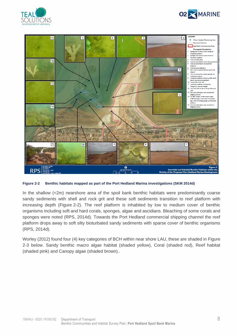
In the shallow (<2m) nearshore area of the spoil bank benthic habitats were predominantly coarse
sandy sediments with shell and rock grit and these soft sediments transition to reef platform with
increasing depth (Figure 2-2). The reef platform is inhabited by low to medium cover of benthic
organisms including soft and hard corals, sponges, algae and ascidians. Bleaching of some corals and
sponges were noted (RPS, 2014d). Towards the Port Hedland commercial shipping channel the reef
platform drops away to soft silty bioturbated sandy sediments with sparse cover of benthic organisms
(RPS, 2014d).
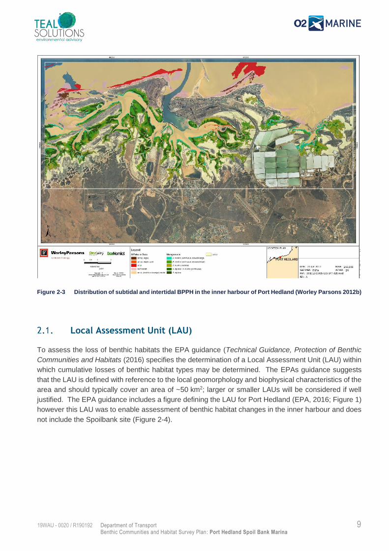
Worley (2012) found four (4) key categories of BCH within near shore LAU, these are shaded in Figure
2-3 below. Sandy benthic macro algae habitat (shaded yellow), Coral (shaded red), Reef habitat
(shaded pink) and Canopy algae (shaded brown)..
9 Department of Transport
Benthic Communities and Habitat Survey Plan: Port Hedland Spoil Bank Marina
19WAU - 0020 / R190192
Figure 2-3 Distribution of subtidal and intertidal BPPH in the inner harbour of Port Hedland (Worley Parsons 2012b)
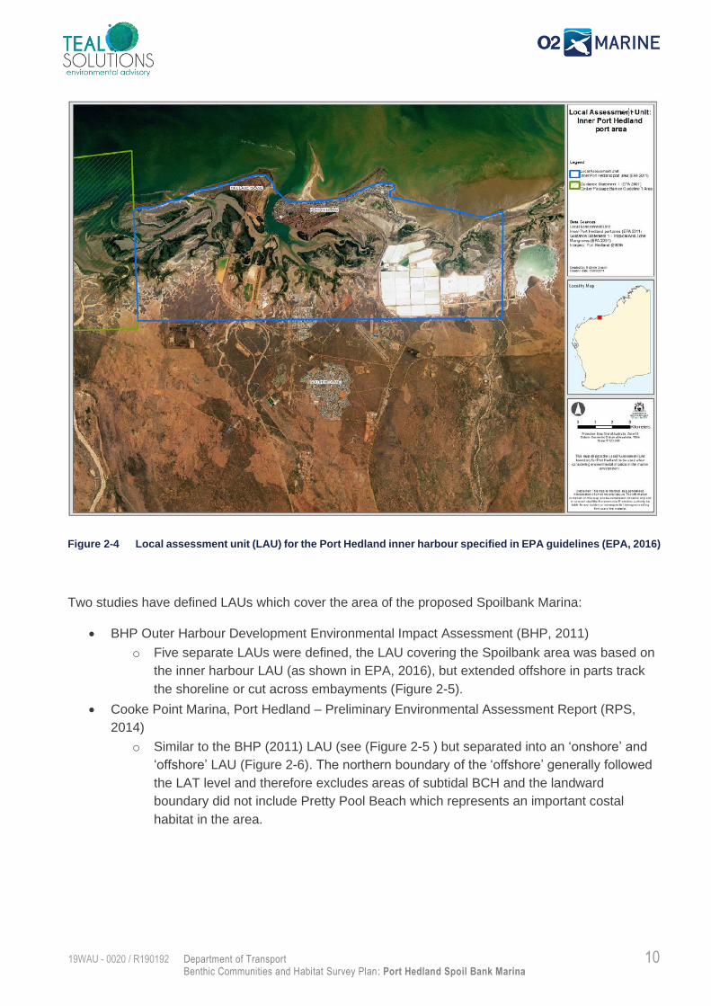
Local Assessment Unit (LAU)
To assess the loss of benthic habitats the EPA guidance (Technical Guidance, Protection of Benthic
Communities and Habitats (2016) specifies the determination of a Local Assessment Unit (LAU) within
which cumulative losses of benthic habitat types may be determined. The EPAs guidance suggests
that the LAU is defined with reference to the local geomorphology and biophysical characteristics of the
area and should typically cover an area of ~50 km2; larger or smaller LAUs will be considered if well
justified. The EPA guidance includes a figure defining the LAU for Port Hedland (EPA, 2016; Figure 1)
however this LAU was to enable assessment of benthic habitat changes in the inner harbour and does
not include the Spoilbank site (Figure 2-4).
10 Department of Transport
Benthic Communities and Habitat Survey Plan: Port Hedland Spoil Bank Marina
19WAU - 0020 / R190192
Figure 2-4 Local assessment unit (LAU) for the Port Hedland inner harbour specified in EPA guidelines (EPA, 2016)
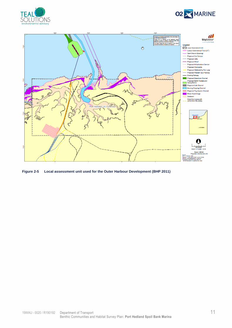
Two studies have defined LAUs which cover the area of the proposed Spoilbank Marina:
• BHP Outer Harbour Development Environmental Impact Assessment (BHP, 2011)
o Five separate LAUs were defined, the LAU covering the Spoilbank area was based on
the inner harbour LAU (as shown in EPA, 2016), but extended offshore in parts track
the shoreline or cut across embayments (Figure 2-5).
• Cooke Point Marina, Port Hedland – Preliminary Environmental Assessment Report (RPS,
2014)
o Similar to the BHP (2011) LAU (see (Figure 2-5 ) but separated into an ‘onshore’ and
‘offshore’ LAU (Figure 2-6). The northern boundary of the ‘offshore’ generally followed
the LAT level and therefore excludes areas of subtidal BCH and the landward
boundary did not include Pretty Pool Beach which represents an important costal
habitat in the area.
11 Department of Transport
Benthic Communities and Habitat Survey Plan: Port Hedland Spoil Bank Marina
19WAU - 0020 / R190192
Figure 2-5 Local assessment unit used for the Outer Harbour Development (BHP 2011)
12 Department of Transport
Benthic Communities and Habitat Survey Plan: Port Hedland Spoil Bank Marina
19WAU - 0020 / R190192
Figure 2-6 Local assessment unit proposed for the Cooke Point Marina (RPS, 2014)
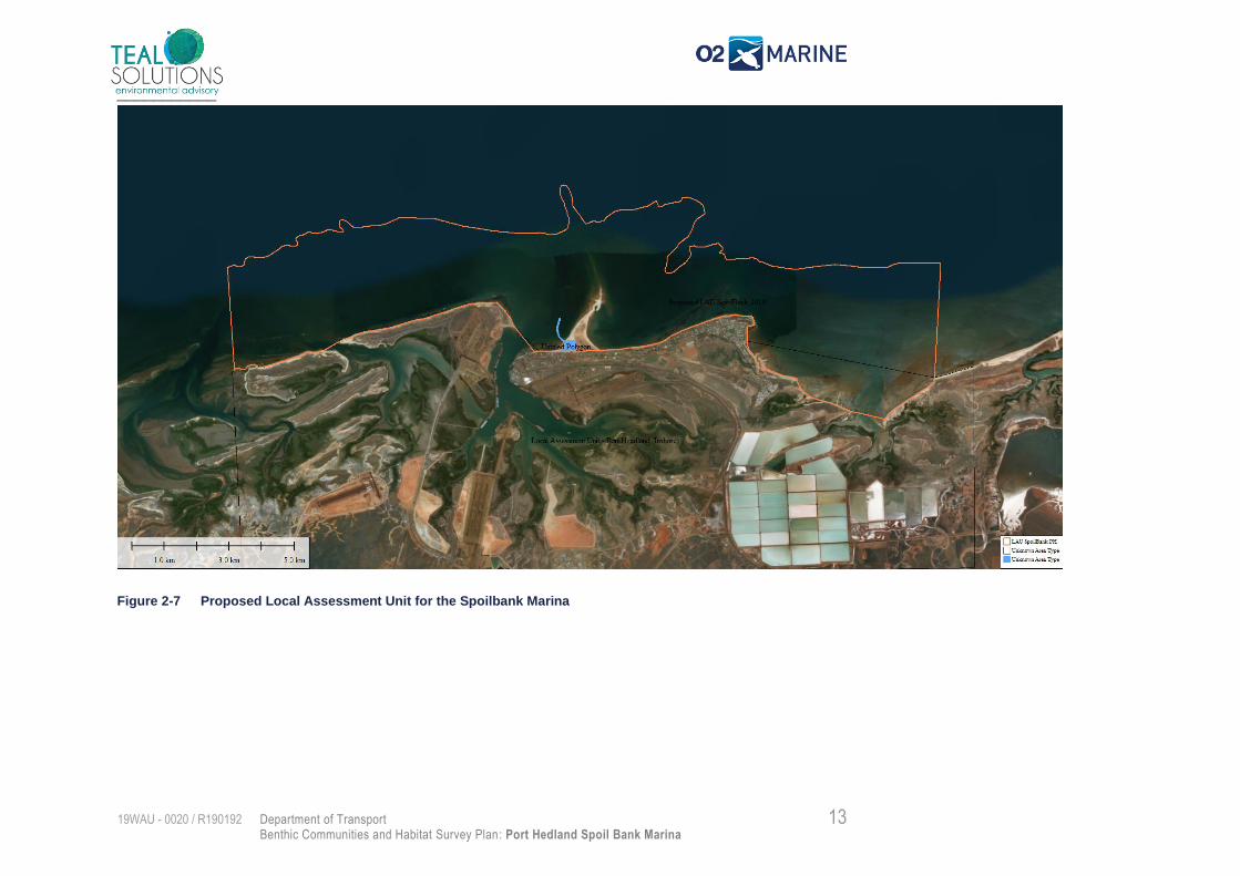
For assessment of the Spoilbank Marina we propose to use a modified version of the ‘offshore’ LAU
defined for Cooke Point (Figure 2-6).
The offshore boundary of the Cooke Point Marina LAU was (for most of its length) only extended to
the 0m LAT, hence only representative of the intertidal habitat. To ensure that the new proposed LAU
is representative of subtidal habitat, and enable assessment of potential impacts from channel
construction, the offshore boundary of this LAU was extended to the -2m LAT and the landward
boundary generally follows the shoreline and includes Pretty Pool Beach (Figure 2-7). This LAU covers
an area of 71.2 km2 and will be used to assess the cumulative impacts to marine coastal intertidal and
subtidal benthic habitats resulting from:
• Historical losses;
• Direct losses due to construction footprint of Spoilbank Marina; and
• Indirect losses arising during construction of the Spoilbank Marina (e.g. dredge plume
impacts).
13 Department of Transport
Benthic Communities and Habitat Survey Plan: Port Hedland Spoil Bank Marina
19WAU - 0020 / R190192
___________
Figure 2-7 Proposed Local Assessment Unit for the Spoilbank Marina
14 Department of Transport
Benthic Communities and Habitat Survey Plan: Port Hedland Spoil Bank Marina
19WAU - 0020 / R190192
3. Survey Locations
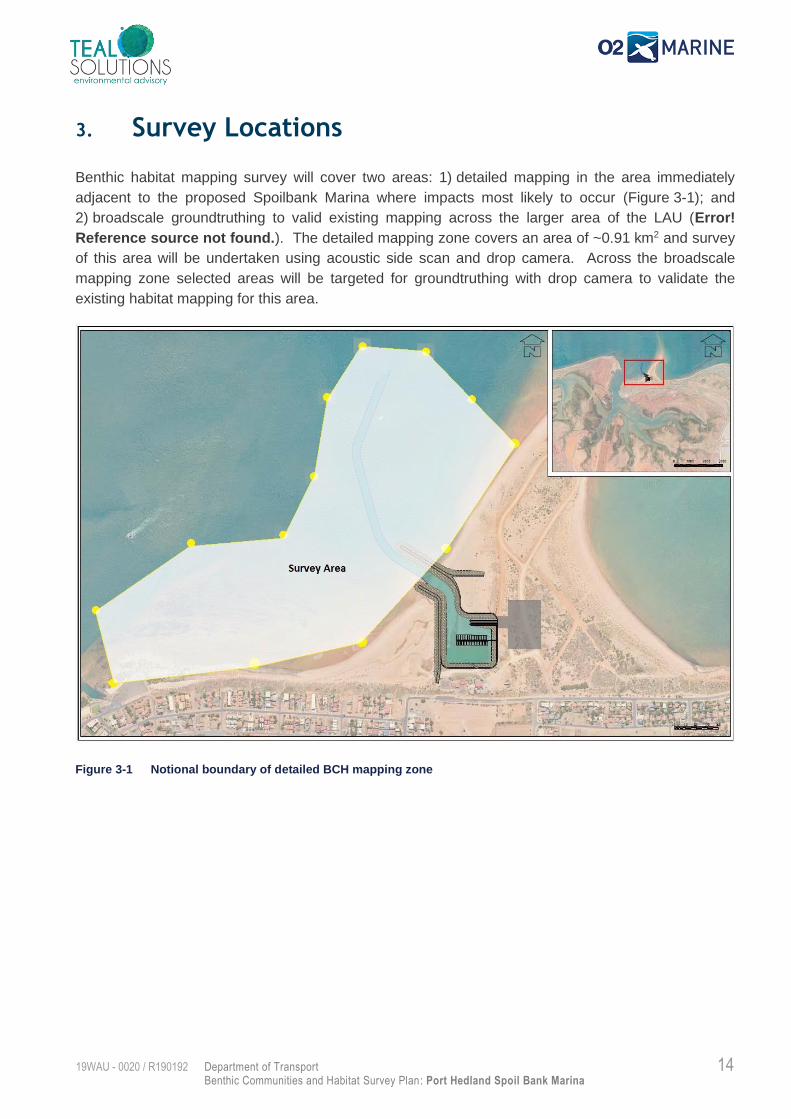
Benthic habitat mapping survey will cover two areas: 1) detailed mapping in the area immediately
adjacent to the proposed Spoilbank Marina where impacts most likely to occur (Figure 3-1); and
2) broadscale groundtruthing to valid existing mapping across the larger area of the LAU (Error!
Reference source not found.). The detailed mapping zone covers an area of ~0.91 km2 and survey
of this area will be undertaken using acoustic side scan and drop camera. Across the broadscale
mapping zone selected areas will be targeted for groundtruthing with drop camera to validate the
existing habitat mapping for this area.
Figure 3-1 Notional boundary of detailed BCH mapping zone
15 Department of Transport
Benthic Communities and Habitat Survey Plan: Port Hedland Spoil Bank Marina
19WAU - 0020 / R190192
4. Methods
Data Collection
The vessel ‘Freedom 2’ (owned and operated by O2 Marine; see Appendix A for specifications) will be
used to undertake the BCH surveys and shall be launched from the Port Hedland Boat Ramp (~1.2 km
from the project site). Three days have been allowed to undertake the field survey: one day to cover
the detailed mapping zone and two days to complete the broadscale mapping zone. Relatively
quiescent sea conditions are required to collect accurate side scan data so the specific timing of this
survey method will be governed by weather conditions. Prior to mobilisation, predicted weather and
tides conditions for Port Hedland will be monitored to ensure suitability for the proposed field operations.
Two suitably qualified O2 Marine scientists (at least one holding a Coxswain Grade 2 certificate) will
undertake the surveys within daylight hours.
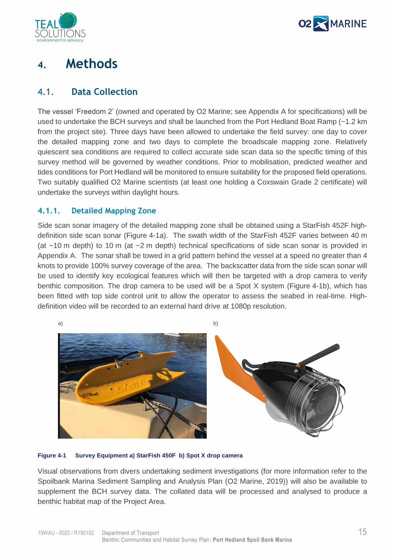
4.1.1. Detailed Mapping Zone
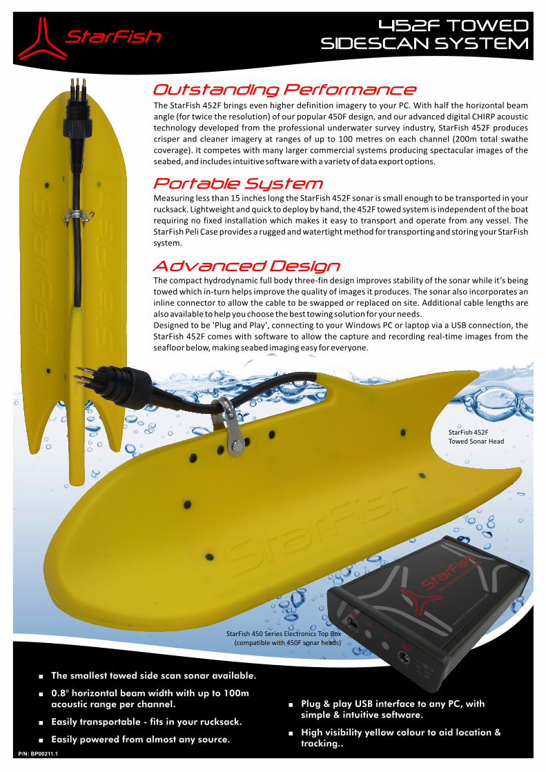
Side scan sonar imagery of the detailed mapping zone shall be obtained using a StarFish 452F high-
definition side scan sonar (Figure 4-1a). The swath width of the StarFish 452F varies between 40 m
(at ~10 m depth) to 10 m (at ~2 m depth) technical specifications of side scan sonar is provided in
Appendix A. The sonar shall be towed in a grid pattern behind the vessel at a speed no greater than 4
knots to provide 100% survey coverage of the area. The backscatter data from the side scan sonar will
be used to identify key ecological features which will then be targeted with a drop camera to verify
benthic composition. The drop camera to be used will be a Spot X system (Figure 4-1b), which has
been fitted with top side control unit to allow the operator to assess the seabed in real-time. High-
definition video will be recorded to an external hard drive at 1080p resolution.
Figure 4-1 Survey Equipment a) StarFish 450F b) Spot X drop camera
Visual observations from divers undertaking sediment investigations (for more information refer to the
Spoilbank Marina Sediment Sampling and Analysis Plan (O2 Marine, 2019)) will also be available to
supplement the BCH survey data. The collated data will be processed and analysed to produce a
benthic habitat map of the Project Area.
a)
b)
16 Department of Transport
Benthic Communities and Habitat Survey Plan: Port Hedland Spoil Bank Marina
19WAU - 0020 / R190192
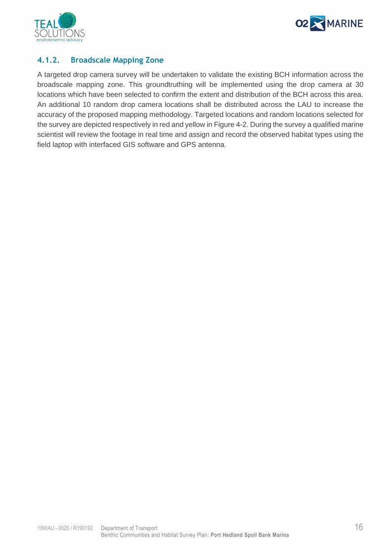
4.1.2. Broadscale Mapping Zone
A targeted drop camera survey will be undertaken to validate the existing BCH information across the
broadscale mapping zone. This groundtruthing will be implemented using the drop camera at 30
locations which have been selected to confirm the extent and distribution of the BCH across this area.
An additional 10 random drop camera locations shall be distributed across the LAU to increase the
accuracy of the proposed mapping methodology. Targeted locations and random locations selected for
the survey are depicted respectively in red and yellow in Figure 4-2. During the survey a qualified marine
scientist will review the footage in real time and assign and record the observed habitat types using the
field laptop with interfaced GIS software and GPS antenna.
17 Department of Transport
Benthic Communities and Habitat Survey Plan: Port Hedland Spoil Bank Marina
19WAU - 0020 / R190192
Figure 4-2 Proposed drop camera survey locations
18 Department of Transport
Benthic Communities and Habitat Survey Plan: Port Hedland Spoil Bank Marina
19WAU - 0020 / R190192
Data Processing
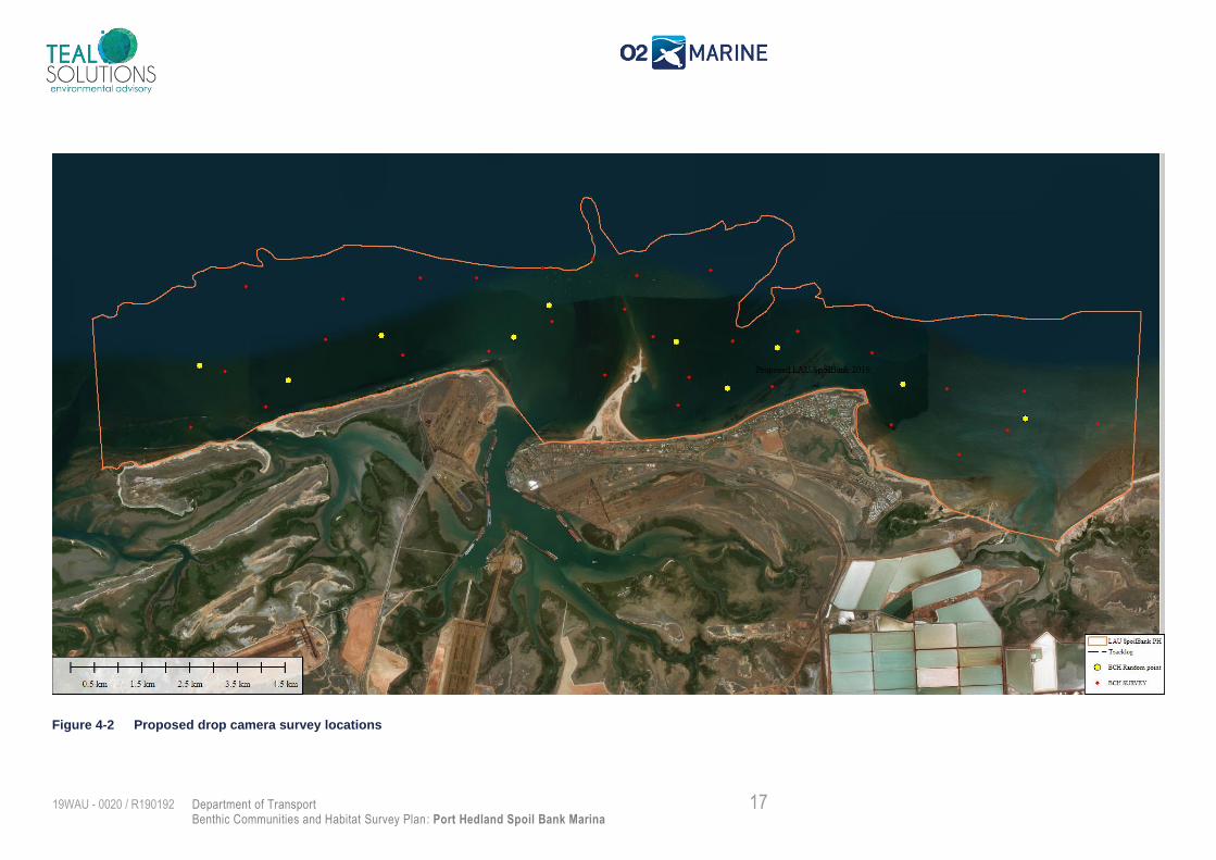
Following collection, the drop camera footage will be analysed by an experienced marine scientist to
review and confirm the benthic classification for each survey location. This information will be reviewed
together with the existing BCH mapping to produce an updated BCH across the LAU. The side scan
sonar backscatter data shall be analysed (using Sonarwiz.5 software) to determine a series of seabed
classes which will be assigned to a habitat classification using ‘acoustic supervised classification’ with
reference to the drop camera footage (Figure 4-3).
Figure 4-3 Example of side scan data processing: (A) backscatter image of seabed B) classified acoustic image C)
validation of target via drop camera)
19 Department of Transport
Benthic Communities and Habitat Survey Plan: Port Hedland Spoil Bank Marina
19WAU - 0020 / R190192
5. Deliverables
Following completion of the BCH surveys, Teal/O2 Marine will produce a Benthic Communities &
Habitat Analysis Report which will include:
1. Literature review
2. Description of methods used
3. BCH map of the detailed mapping area;
4. BCH map of the LAU;
5. Descriptions of substrate, bedforms, habitat and species observed;
20 Department of Transport
Benthic Communities and Habitat Survey Plan: Port Hedland Spoil Bank Marina
19WAU - 0020 / R190192
6. Reference List
EPA (2016). Technical Guidance. Protection of Benthic Communities and Habitats. Environmental
Protection Authority. Western Australia.
O2 Marine (2019). Port Hedland Spoilbank Marina, Sediment Sampling and Analysis Plan. O2 Marine
Report Number R190188. Perth, Western Australia
RPS (2014). Water Quality Report. Proposed Port Hedland Marina Development. RPS Environment
and Planning Pty Ltd. Report Number L1314906. Perth, Western Australia.
RPS (2014b). Preliminary Environmental Assessment Report. Cooke Point Marine, Port Hedland.
Western Australia.
BHP (2011). Outer Harbour Development, Public Environmental Review/Draft Environmental Impact
Statement, Section 10, Marine Impacts and Management. Western Australia.
Worley Parsons (2012). South West Creek Dredging and Reclamation Project. Benthic Primary
Producer Habitat Survey and Cumulative Loss Assessment: Port Hedland Local Assessment Unit.

A Department of Transport
Benthic Communities and Habitat Survey Plan: Port Hedland Spoil Bank Marina
19WAU - 0020 / R190192
Appendix A Technical Specification - Starfish 452 Side Scan Sonar
452F TOWED SIDESCAN SYSTEM
P/N: BP00211.1
The compact hydrodynamic full body three-fin design improves stability of the sonar while it’s being towed which in-turn helps improve the quality of images it produces. The sonar also incorporates an inline connector to allow the cable to be swapped or replaced on site. Additional cable lengths are also available to help you choose the best towing solution for your needs.Designed to be 'Plug and Play', connecting to your Windows PC or laptop via a USB connection, the StarFish 452F comes with software to allow the capture and recording real-time images from the seafloor below, making seabed imaging easy for everyone.
The StarFish 452F brings even higher definition imagery to your PC. With half the horizontal beam angle (for twice the resolution) of our and our advanced digital CHIRP acoustic technology developed from the professional underwater survey industry, StarFish 452F produces crisper and cleaner imagery at ranges of up to 100 metres on each channel (200m total swathe coverage). It competes with many larger commercial systems producing spectacular images of the seabed, and includes intuitive software with a variety of data export options.
popular 450F design,
Measuring less than 15 inches long the StarFish 452F sonar is small enough to be transported in your rucksack. Lightweight and quick to deploy by hand, the 452F towed system is independent of the boat requiring no fixed installation which makes it easy to transport and operate from any vessel. The StarFish Peli Case provides a rugged and watertight method for transporting and storing your StarFish system.
Portable System
Outstanding Performance
Advanced Design
StarFish 450 Series Electronics Top Box(compatible with 450F sonar heads)
StarFish 452FTowed Sonar Head
+Plug & play USB interface to any PC, with simple & intuitive software.
+High visibility yellow colour to aid location & tracking..
+The smallest towed side scan sonar available.
+0.8° horizontal beam width with up to 100m acoustic range per channel.
+Easily transportable - fits in your rucksack.
+Easily powered from almost any source.
452F TOWED SIDESCAN SYSTEM
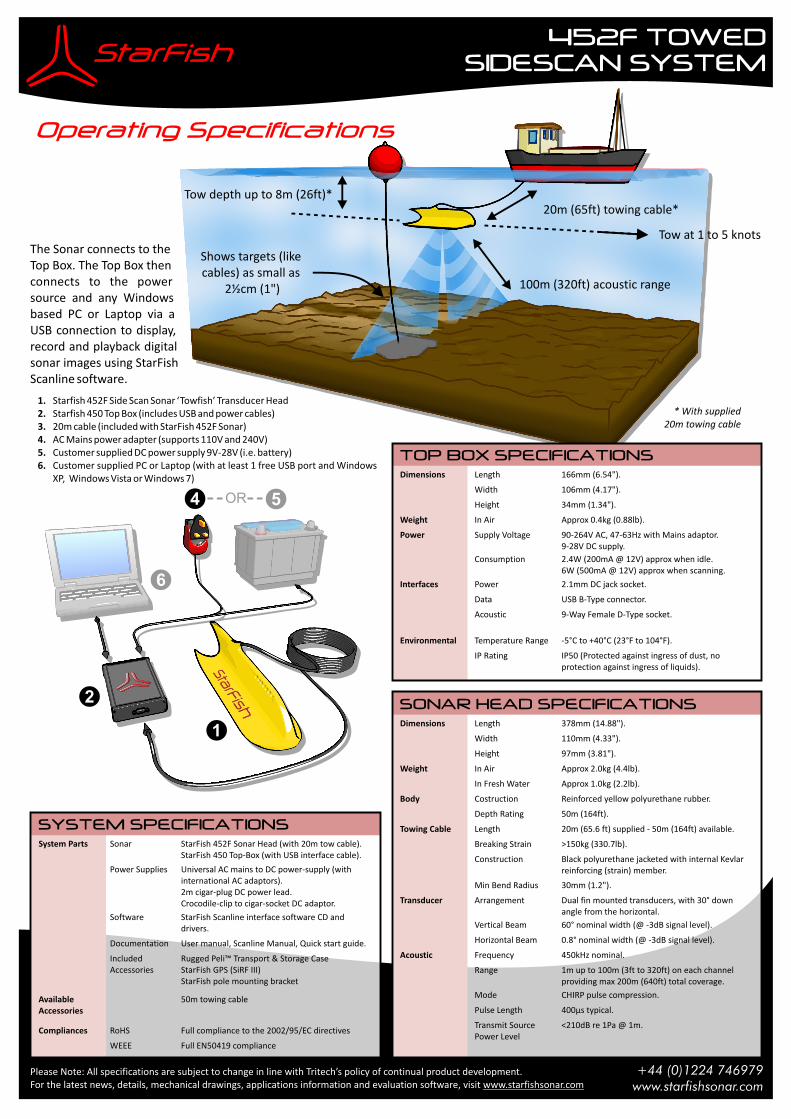
Tow at 1 to 5 knots
Tow depth up to 8m (26ft)*20m (65ft) towing cable*
100m (320ft) acoustic range
Shows targets (likecables) as small as
2½cm (1")
Operating Specifications
Please Note: All specifications are subject to change in line with Tritech’s policy of continual product development.For the latest news, details, mechanical drawings, applications information and evaluation software, visit www.starfishsonar.com
The Sonar connects to the Top Box. The Top Box then connects to the power source and any Windows based PC or Laptop via a USB connection to display, record and playback digital sonar images using StarFish Scanline software.
1. Starfish 452F Side Scan Sonar ‘Towfish’ Transducer Head2. Starfish 450 Top Box (includes USB and power cables) 3. 20m cable (included with StarFish 452F Sonar) 4. AC Mains power adapter (supports 110V and 240V) 5. Customer supplied DC power supply 9V-28V (i.e. battery) 6. Customer supplied PC or Laptop (with at least 1 free USB port and Windows
XP, Windows Vista or Windows 7)
+44 (0)1224 746979www.starfishsonar.com
6
1
2
4 5OR
TOP BOX SPECIFICATIONS
Dimensions Length 166mm (6.54").
Width 106mm (4.17").
Height 34mm (1.34").
Weight In Air Approx 0.4kg (0.88lb).
Power Supply Voltage 90-264V AC, 47-63Hz with Mains adaptor.9-28V DC supply.
Consumption 2.4W (200mA @ 12V) approx when idle.6W (500mA @ 12V) approx when scanning.
Interfaces Power 2.1mm DC jack socket.
Data USB B-Type connector.
Acoustic 9-Way Female D-Type socket.
Environmental Temperature Range -5°C to +40°C (23°F to 104°F).
IP Rating IP50 (Protected against ingress of dust, no protection against ingress of liquids).
System Parts Sonar StarFish 452F Sonar Head (with 20m tow cable).StarFish 450 Top-Box (with USB interface cable).
Power Supplies Universal AC mains to DC power-supply (with international AC adaptors).2m cigar-plug DC power lead.Crocodile-clip to cigar-socket DC adaptor.
Software StarFish Scanline interface software CD and drivers.
Documentation User manual, Scanline Manual, Quick start guide.
Included Accessories
Rugged Peli™ Transport & Storage CaseStarFish GPS (SiRF III)StarFish pole mounting bracket
Available Accessories
50m towing cable
Compliances RoHS Full compliance to the 2002/95/EC directives
WEEE Full EN50419 compliance
SYSTEM SPECIFICATIONS
SONAR HEAD SPECIFICATIONS
Dimensions Length 378mm (14.88").
Width 110mm (4.33").
Height 97mm (3.81").
Weight In Air Approx 2.0kg (4.4lb).
In Fresh Water Approx 1.0kg (2.2lb).
Body Costruction Reinforced yellow polyurethane rubber.
Depth Rating 50m (164ft).
Towing Cable Length 20m (65.6 ft) supplied - 50m (164ft) available.
Breaking Strain >150kg (330.7lb).
Construction Black polyurethane jacketed with internal Kevlar reinforcing (strain) member.
Min Bend Radius 30mm (1.2").
Transducer Arrangement Dual fin mounted transducers, with 30° down angle from the horizontal.
Vertical Beam 60° nominal width (@ -3dB signal level).
Horizontal Beam 0.8° nominal width (@ -3dB signal level).
Acoustic Frequency 450kHz nominal.
Range 1m up to 100m (3ft to 320ft) on each channel providing max 200m (640ft) total coverage.
Mode CHIRP pulse compression.
Pulse Length 400µs typical.
Transmit Source Power Level
<210dB re 1Pa @ 1m.
* With supplied20m towing cable


