Thunder Rock Exploration, Inc. P.O. Box 769 Fulshear, Texas 77441-0769 (281) 533-9440 Office (281) 685-3047 Mobile [email protected][email protected]James G. Kane Certified Petroleum Geologist #4273 Certified Petroleum Geophysicist #06 SIPES #2331 Berclair Field, East Prospect Goliad County, Texas 16 Stacked Oil and Gas Pays Vicksburg, Frio and Miocene
Transcript
Thunder Rock Exploration, Inc. P.O. Box 769 Fulshear, Texas 77441-0769 (281) 533-9440 Office (281) 685-3047 Mobile [email protected][email protected] James G. Kane Certified Petroleum Geologist #4273 Certified Petroleum Geophysicist #06 SIPES #2331
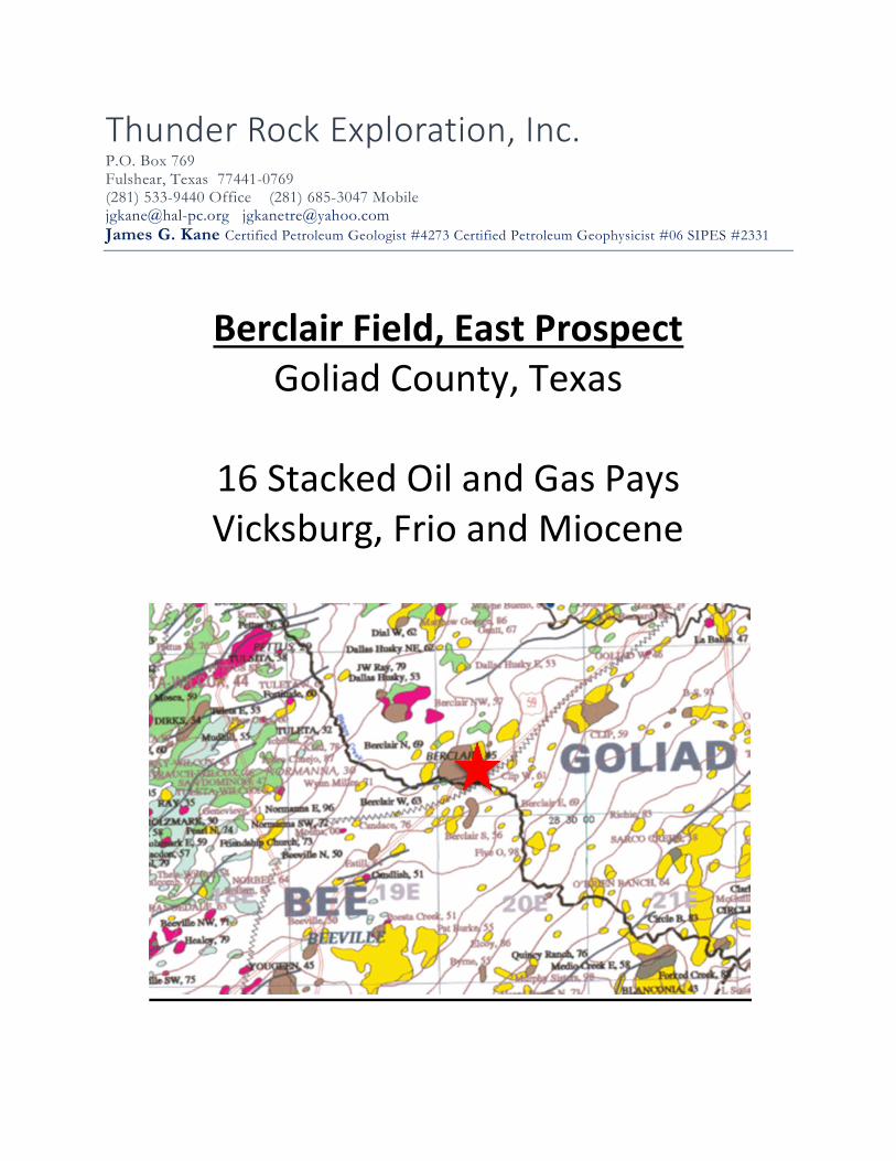
Berclair Field, East Prospect Goliad County, Texas
16 Stacked Oil and Gas Pays Vicksburg, Frio and Miocene
EXECUTIVE SUMMARY
The Berclair Field, East Prospect is located in the prolific Berclair Field in Goliad County, Texas. The Berclair Field has produced in excess of 12,800,000 barrels of oil and 2.8 billion cubic feet of gas from the Vicksburg formation at a depth of 3,300’ since the early 1950’s. The field has also made in excess of 3,100,000 barrels of oil and .74 billion cubic feet of gas from the Frio formation at depths between 2,200’ and 2,800’. Detailed subsurface mapping has revealed an untested upthrown fault closure within the confines of the original Field along with significant channel sand development in the Frio formation that is not present in the main body of the field. These channel sands trap both oil and gas in the immediate area. A test well was drilled in November of 2018. After open hole logging and sidewall core analysis, the well was determined to have 7 oil pays with associated gas and 10 gas pays with associated liquids in the Vicksburg, Frio and Miocene formations. The well was drilled to a depth of 3,315’. Oil was found in the Vicksburg formation and a completion attempt was made. It was soon discovered that the original cement job was done incorrectly. Two remedial squeeze jobs were attempted, both failing. This oil zone was abandoned due to the failed cement job and squeezes. Three other zones were perforated (2 with no sidewall core information and 1 with 10’ oil cores). The zone produced about 40 Bw/d with a skim of oil. The well was then shut-in for over a year with water over the oil sand perforations. It was determined that the water was coming from the two lower perforations, not the 10’ thick oil sand at 2,700’. A bridge plug was set to seal off the water sands. The oil zone at 2,700’ appeared to be significantly damaged from the water that had sat over the perforations for over a year. A gas gun was set off to try to stimulate the oil zone. The well started flowing imulsived oil. It appeared once again, that the unconsolidated sands in the oil zone at 2,700’ were damaged by the gas gun and the downhole pump has trash in it and the well was shut-in and remains so today. 80 acres offsetting this well has been leased. In the 2,700’ oil sand, it appears that you can get about 37’ high structurally to this shut-in and damaged well and possibly double the sand thickness to 20’ or greater of oil pay. The other stacked pays should be present in the area also. A total depth of about 3,300’ would be necessary to test the top of the Vicksburg formation and the stacked Frio and Miocene pays in the offsetting well.
Berclair Field, East Prospect Objectives and Potential Reserves – 6.7 Bcfg and 151,000 Bo 1. Miocene 1,370’ Sand .4 Bcfg and Associated liquids 2. Miocene 1,400’ Sand .4 Bcfg and Associated liquids 3. Miocene 1,450’ Sand .4 Bcfg and Associated liquids 4. Miocene 1,500’ Sand .4 Bcfg and Associated liquids 5. Miocene 1,550’ Sand .4 Bcfg and Associated liquids 6. Frio 1,700’ Sand .4 Bcfg and Associated liquids
7. Frio 2,300’ “A” Sand .4 Bcfg and 9,000 Bo 8. Frio 2,300’ “B” Sand .4 Bcfg and 9,000 Bo 9. Frio 2,300’ “C” Sand .2 Bcfg and 4,500 Bo 10. Frio 2,300’ “D” Sand .2 Bcfg and 4,500 Bo 11. Frio 2,400’ “B” Sand 9,000 Bo and Associated Gas 12. Frio 2,500’ “A” Sand .9 Bcfg and Associated liquids 13. Frio 2,500’ “B” Sand .9 Bcfg and Associated liquids 14. Frio 2,500’ “C” Sand .9 Bcfg and Associated liquids 15. Frio 2,600’ “A” Sand .4 Bcfg and Associated liquids 16. Frio 2,700’ “A” Sand 115,000 Bo and Associated Gas 17. Vicksburg “A” Sand Possibly Low Structurally