224


1

2

3

4

5

6
Problem, objectives and constraints
Problem- Farmers’ technical knowledge of installing sand barrier is insufficient. - Inadequate financial support. - Serious land sandification and pasture degradation. - Drift dune harms farmland, pasture, traffics and houses, thus leading to emergence of ecological refugees.
Objectives- Restrain dune movement and improve ecological quality. - Form steady project financing source. - Raise awareness of communities in the field of ecological protection. - Raise the capability of community in sand control and prevention.
Constraints addressed
Major Specification Treatment
Economic Heavy workload and need of plenty of manpower, material and Increase government inputs on ecological improvement for financial resources. The project area is featured by poor economy sandy area. and communication conditions, and local people’s life is hard.
Minor Specification Treatment
Social Sandy area management is concerned with various sectors, Establish coordination mechanism of equal participation including agriculture, animal husbandry as well as local residents, of stakeholders. so unified organization and coordination are necessary.
Participation and decision making
Targetgroups
Decision maker Land user Designer SWC expert
Decisions on choice of the technology: Banner government. Decisions on method of implementing the technology: Banner forestry bureau. Approach designed by: Technicians of the Banner forestry bureau.
Communityinvolvement
Phase Involvement Activities
Initiation Interaction Convene mobilization meeting of villagers to discuss and make decision.
Planning Interaction Organize discussions on the spot to identify solution, and technicians make site check, measure and prepare work plans.
Implementation Active Conduct site training courses on operational technology for the local people, and organize them establishing sand barrier and forest.
Monitoring/evaluation Passive Set fixed spot for monitoring to check sand barrier (sampling method), vegetation growth and sand fixation. Villagers may offer some observation data.
Research No No participation.
Differences in participation of men and women: Due to the heavy labour requirement, there is less female participation.
Approach costs met by
Farmer 7%
Government 93%
TOTAL 100%

7
Extension and promotion Training:Training content: basic knowledge of sand barrier installation, e.g. specifications, burial depth, material and required quan-tity; Training method: explanation and demonstration in the field; The training results are good for trainees that actually execute the operations.
Extension: Professionals of Banner Forestry Bureau go to villages to conduct training on the main topics.
Research: Work stations of the Banner Forestry Bureau conduct studies on the protection benefits generated by mechanical sand barrier.
Importanceoflanduserights:The desertified land is barren having no direct economic income, nevertheless all the land owners accept the technology. The land use right and ownership rights do not affect the technology application.
Incentive mechanismLabour:The labour is not paid.
Inputs:Costs of seedling, crop straw, vehicles, maintenance are covered by central and banner government while labor force by lo-cal villagers.
Credit: The bank offers micro-loans.
Supportoflocalinstitutions:The implementation gained reputation of forestry department among local people, increased attention of autonomous region government and central government to the banner forestry bureau; technical ability of Banner forestry Bureau is improved.
Long-term impact of incentives: This is an ecological project, with little economic benefits. The current incentive policy does not facilitate the sustainable use of the technology from long-term point of view.
Organogram The financial and work plan of the Three-North Shelterbelt Programme is issued by the State Forestry Administration and deliv-ered at lower level forestry sectors.
State Forestry Administration
Banner Forestry Bureau Banner Government
Three-North ShelterbeltConstruction Bureau
Township Government
Autonormous Region Forestry Department
Farmer or herdsmanhouseholds
1. FIXATIO
N O
F SHIFTIN
G SA
ND
S

8
Monitoringandevaluation
Monitored aspects Methods and indicatorsBio-physical Measure vegetation coverage, areas of drift/fixed/semi-fixed dunes, study by comparison changes before and after the operation.
Technical Sand barrier specifications, burial depth and material quality.
Socio-cultural Survey by questionnaire the awareness of local residents of sandification prevention and views on this technology.
Economic/production Vegetation restoration, economic benefits of the farming and animal husbandry after project implemented.
Area treated Survey of treated area, and its error should not exceed 10% compared with planned area.
No. of land users involved Survey the number of land users and changes of land user structure.
Management of approach Autonomous region and city authorities are responsible for the survey and interview with local residents. Questionnaire will be made with banner governments, township governments and forestry sector.
Impacts of the approach
Changesasresultofmonitoringandevaluation:This technology is executed under leadership of banner government and assis-tance of Three-North Shelterbelts Programme. The intensity of management and villager participation has increased, and the effect is better compared with the past practices.
Improved soil and water management: Shift sand gets is fixed and vegetation is restored.
Adoptionoftheapproachbyotherprojects/landusers:This method has been accepted by adjacent areas.
Sustainability:Those with long-term land use right would adopt the technology without long term support. Other types of land us-ers feel hard to keep sustainable application of the technology without government support.
Concludingstatements
Strengthens and →howtosustain/improve
Strong willingness of villagers to participate in project has solved problem of labour supply → Improve the economic subsidy mechanism.
Easy technological extension and good results of sand control → Combination with development to strengthen effect.
Weaknesses and → how to overcome
Land use right has impact on farmers enthusiasm → Implement long-term land contracting system.
No direct economic benefit of technology → Research on measures on reasonable resource use.
Key reference(s) [1] State Forestry Administration. Forestry ecological improvements and management models in Western China. Beijing: China
Forestry Publication House, 2000[2] Forestry Department of Inner Mongolia Autonomous Region. Collection of the Achievements of Science and Technology of For-
estry in Inner Mongolia. 2001
Contact person(s) Tian Lü, Inner Mongolia Forestry Survey and Design Institute. Tel: 0471-5953487. Email: [email protected]

9
Left: High vertical living sand barrier. Photo by Yang ZihuiRight: Sand accumulation function of high vertical living sand barrier. Photo by Yang Zi-hui
Location: Jiuquan city, Gansu ProvinceTechnologyarea: 25km2
SWCmeasure: Vegetation measureLanduse: OthersClimate: Arid WOCATdatabasereference:QTRelated approach: Researcher-Enterprise Cooperation to Control Desert Harm to Rail-way by Using Living Barriers Compiled by: Yang Zihui, and Zhao Ming, Gansu Desert Control Research Institute Date: August, 2007
Editors’ comments: This technology of high vertical living barrier, featuring satisfactory results, helps to gather sand to form big sand pileups. Accordingly it slows down the drift of sand. As an economical and practical technol-ogy of protecting main road, oasis farmland, it deserves extension in similar areas of the world.
High Vertical Living Sand Barriers Jiuquan City of Gansu Province, China
High vertical living barrier is a protective barrier set in the wind and sand stricken areas. The barrier with certain height and penetrability is made up of growing plants suitable for dry and sandy conditions to alleviate the wind and sand drifting speed through the rows of plants, and finally piling up the drifting sand. It is an effective sand fixation approach to protect infrastructure from being ravaged.
Vast deserts are distributed in north China where soil is seriously desertified. The rail-way service has experienced frequent suspensions in Qingshui section of Lanzhou-Xinjiang railway line suffering immense economic losses. In 1980s, the railway de-partment raised funds to construct high vertical living barrier with technical support provided by Gansu Desert Control Research Institute. Since its operation, the project has played an important role in intercepting sand encroachment and protection of nor-mal operation of railway service.
The high vertical living barrier is set in a strip formation in the areas where wind and desert hazard is severe. 2-4 belts of windbreak are proper for the seriously affected areas and 1-2 belts are suitable for lightly affected places. Specifically, the first belt of windbreak should be planted perpendicular to the wind direction about 200m to the rail tracks to be protected at the windward side. Further, windbreaks should be planted in 20m intervals to total 2-4 belts in parallel with the first one. Calligonum klementzii, Haloxylon ammodendron, Salix psammophila, etc. may be planted. 25cm or longer cuttings, or one year old seedlings in 30cm are proper for the plantation of Calligonum and Salix psammophila; one year old seedlings of 30cm in length suits planting of Haloxylon ammodendron. Initial density should be kept in 10-12 trees/m. After tree planted, drip irrigation or other types of irrigation shall be applied in low moisture dunes to facilitate survival of the plants.
High vertical living barrier per hectare cost are: Seedling US$150; Labour US$450; Irrigation equipment US$160, and totally US$760.
Wind and drift sand speed is reduced gradually while passing through belts of wind-breaks to retain in the proximity of the barrier and gradually retard the encroachment of desert and the drift sand movement along with growth of the plants. These types of barrier is able to anchor local drift sand and retain the sands blown in from other sources to convert scattered movable little dunes or drift sand into big dunes or form “barrier dam” and sand hill to mitigate dune movement speed and serve the purpose of gathering drift sand.
In the areas with annual rainfall over 150mm, high vertical living barrier may have continuous sand retaining function. This technology is broadly used in desert control for railway and highway and regarded as a sand capture and fixation technology featuring less investment and long-term benefit. Supplementary planting and main-tenance should be timely conducted in case of dead trees found. When trees grow up, thinning and trimming should be conducted to maintain 20% penetrability. In dry seasons, water the trees to keep proper moisture. Annual maintenance cost is esti-mated at US$175 per hm2.
1. FIXATIO
N O
F SHIFTIN
G SA
ND
S

10
Landuserights:collectiveLand ownership: state Market orientation: mixedLeveloftechnicalknowledgerequired:moderate for extensionists but low for land usersImportance of off-farm income: 10%-50% of the total income
Humanenvironment
Mixedlandperhousehold(hm2)
<1 1–2 2–5 5–15 15–50 50–100 100–500 500–1000 1000–10000 >10000
secondary: - add vegetation cover
very steep (>60)steep (30–60)hilly (16–30)rolling (8–16)moderate (5–8)gentle (2–5)flat (0–2)
Growing season: 185 days in succession, from April to October Soil fertility: lowSoiltexture:coarse sandySurfacestoniness: moderate, with intense sand grain Topsoilorganicmatter:low (<1%) Soil drainage: goodSoil erodibility: very high
>4000 >4000 3000–4000 3500–4000 2000–3000 3000–3500 1500–2000 2500–3000 1000–1500 2000–2500 750–1000 1500–2000 500–750 1000–1500 250–500 1000–500 <250 <500
Soil depth (cm)
0–20 20–50 50–80 80–120 >120
Classification
LanduseproblemsThe drifting sand buries the railway.
Landuse Climate Degradation SWCmeasure
Calligonum Arid Wind erosion Vegetation mongolicum, measureHaloxylonammodendron etc
Technicalfunction/impactmain: - gather the sand and prevent it from moving - lowing the wind speed
Environment
NaturalEnvironment
Averageannualrainfall(mm) Altitude(ma.s.l.) Landform Slope(%)
ridges
ridgeshill slopes
foot slopesvalley floors
mountain slopes
plains/plateaus

11
Technicaldrawing
Select suitable plant species and de-termine row spacing and specifica-tions according to drift sand condition, espe-cially drift intensity, and to form a high vertical barrier.
Drawing by Guo Shujiang
prevailing wind
belt
dune facial line
high living barrier
fourth cyclethird cycle
second cyclefirst cycle
Profileofhighverticalbarrierplantedonline-shapedsandaccumulatingdunes
Implementationactivities,inputsandcosts
Establishmentinputsandcostsperhm2
Inputs Costs(US$) %metbylanduser
Labour 450 100
Equipment
- mainly for irrigation: bucket, 160 100 spade, water vehicle, dripping irrigation equipment etc.
Materials
- Seedlings and clonal cuttings etc. 150 100 Agricultural
TOTAL 660 100
Establishment activities1. High vertical live sand barrier is built in spring. 2. Laying out. On drift sand site, draw straight line perpen-dicular to the prevailing wind direction for afforestation, at the span of about 20m. 3. Afforestation. Select cuttings of C. klementzii (more than 20cm in length and over 0.8 cm in diameter, one year growth branch) and one year seedlings of Haloxylon ammodendron for planting, with plant space 10 cm or more. The propotion between C. klementzii and Haloxylon ammodendron is 10:1. 4. Watering. Watering of one time is necessary when the soil moisture is low at the planting time.
Establishment time: 2 years.
Remarks: none.
Maintenance/recurrentactivities1. Check the plant survival condition in the spring following the establishment of the plant barrier, conduct replanting to the unplanted or dead. When replanting the high quality one year old big seedling should be adopted and the dead one should be removed. Seedlings should be used for C. kle-mentzii.2. The live sand barrier built should be looked after by spe-cialized people to avoid damages of domestic animals.3. At the planting year and in the following years, irrigate the plants when the sandy soil moisture content is low.
Maintenance/recurrentinputsandcostsperhm2 per year
Inputs Costs(US$) %metbylanduser
Labour 100 100
Equipment
- mainly for irrigation: bucket, spade, 60 100 water vehicle, dripping irrigation equipment etc.
Materials
- seedlings 15 100
Agricultural
TOTAL 175 100
1. FIXATIO
N O
F SHIFTIN
G SA
ND
S

12
Assessment
Acceptance/adoption- If economic incentive is available, more householders would accept the technology. - Without economic subsidy, less people adopt the technology, and those that accept are the households directly suffered from drift sand. - The future tendency is that the technology is to be adopted for sand dust storm treatment of the main road, oasis in which the lo-
cal government and the transportation sector shall cofinance with householder participation.
Benefits/costsaccordingtolanduser Benefitscomparedwithcosts Short-term Long-term
Benefit the land users both ecologically and economically. establishment very positive very positive
maintenance/recurrent very positive very positive
Impacts of the technology
Productionandsocio-economicbenefits Productionandsocio-economicdisadvantages
+ + + Prevent sand burying road and other facilities None
+ + Improve local industrial and agricultural production conditions
Socio-culturalbenefits Socio-culturaldisadvantages
+ + Raise farmers’ awareness of sand fixation None
Ecologicalbenefits Ecologicaldisadvantages
+ + + Fix drift sand – None
+ + + Reduce ground wind speed
+ + Add vegetation cover of the sand area
Off-sitebenefits Off-sitedisadvantages
+ + + Fix drift sand, reduce wind speed, protect farmland and None other facilities
Concludingstatements
Key reference(s) [1] Dong Zhi, Li Hongli, Hu Chunyuan, Zuo Hejun. Benefit and cost comparative study of wind breaking and sand fixation benefits
to the desert highway by different measures, the Journal of Soil and Water Conservation, 2006[2] Cao Bo, Sun Baoping, Gao Yong, etc. Wind breaking benefit of High vertical Salix psammophlla barriers. Chinese Soil and Wa-
ter Conservation Science, 2007[3] Gansu Minqin Desert Control Experimental Station. Gansu Desert and the Control. LanZhou: Gansu People’s Press, 1974
Contact person(s)Yang Zihui, Gansu Desert Control Research Institute. Tel: 13993539746. Email: [email protected]
Strengthens and →howtosustain/improve
Control drift sand burying road and facilities → Combine with mechanical measure.
Reduce wind speed and improve production condition → Com-bine with shelterbelt forest construction.
Raise vegetation cover and improve ecological condition → Continue to extend application of this technology.
Weaknesses and → how to overcome
Consume dune moisture → Use reasonable plant density and manage-ment measures.

13
Left: Sand fixation by high vertical sand bar-rier. Photo by Yang ZihuiRight: Newly established high vertical living barriers. Photo by Yang Zihui
Location: Jiuquan city, Gansu ProvinceLanduse: OthersClimate: Arid WOCATdatabasereference: QARelated technology: High Vertical Living Sand BarriersCompiled by: Yang zihui, and Zhao Ming, Gansu Desert Control Research Institute Date: August, 2007
Editors’ comments: Financed by the en-terprise and technically supported by the research institute, and encouraged by cash payment, the local farmers are mobilized to install high vertical living barriers, to stabilize drift sand by gathering plenty of sand forming tall big dunes. Consequently, sand drifting slows down, and the project can play impor-tant role in protecting main roads, oasis farm-land and the facilities.
Researcher-Enterprise Cooperation to Control Desert Harm to Railway by Using Living Barriers Jiuquan City of Gansu Province, China
Enterprise (railway service) and scientific research institutions are in cooperation to use the research result “High Vertical Living Barrier Technology”. The research insti-tute and the railway enterprise have established a technology dissemination team to organize farmers to join the railway desert control program to maintain smooth run-ning of railway service.
The railway service has experienced frequent suspensions in the Qingshui section of Jiuquan City of Lanzhou-Xinjiang railway line, due to trans-boundary drift sand intru-sion, the railway service department has to spend substantial manpower and money to remove the sand each year. In 1990s, the railway service department raised funds to construct high vertical living barriers with technical support provided by Gansu Desert Control Research Institute. Since its operation, the project has played an im-portant role in interception of sand encroachment and protection of normal operation of railway service.
In early 1991, Qingshui section of Lanzhou-Xinjiang railway line suffered substan-tial sand disaster. Lanzhou Railway Bureau asked Gansu Sand Control Research Institute for technical support to bring sand hazard in control. After negotiation, it was decided the Bureau would raise funds and the Institute provided technical ser-vice to jointly control the disaster. Desert control leadership group was set up by the Maintenance Department of Lanzhou Railway Bureau and Gansu Desert Control Re-search Institute, and “Qingshui Rail Section Desert Control Group” was established to involve technical personnel from Qingshui desert control work department and the Institute. The group has worked under the leadership group to carry out survey, design and planning for the desert control tasks and high vertical living sand bar-riers was employed for control of the sand harm. By the end of March, 1991, they got seedlings and equipment in place and conducted field training to some farmers, while technicians were explaining the technology alongside demonstrative operation. Thereafter, the farmer trainees became the trainers to more farmers to add to the skilled workers involved in the project, so that the project was rapidly completed.
Cash compensation for labour was adopted as the incentive to encourage farmers to participate. And the compensation was 760 US dollars per hectare of barriers and annual maintenance came to 175 US dollars.
High vertical living barrier has been proven of important function in anchoring local drift sand and retaining sand blown in from other locations to integrate small movable dunes into big ones or form “sand dam” and to diminish dune movement speed and gather sands. This is an effective approach to protect farmland, road and ecosystem.
1. FIXATIO
N O
F SHIFTIN
G SA
ND
S

14
Problem, objectives and constraints
Problem- Lack of effective organization, capital fund, and the community in need of technology of high vertical live sand barrier. - Without direct economic benefits the community’s enthusiasm to participate is low. - Drift sand goes with wind endangering farmland, village, road and channel. - Sand dust cause environmental pollution.
Objectives- Form a technical extension mechanism by integrating researchers and extensionists. - Raise community participation. - Raise community’s capability in ecological protection. - Protect farmland, road and other facilities from harms of sand storms. - Guarantee traffic operation, increase income, improve environment condition, raise people’s living standard.
Constraints addressed
Major Specification Treatment
Economic Project site is located in desert are with backward economy, Form the state-locality-farmer co-financing mechanism: and farmer’s input level is limited. the state offers funds, the locality offers materials such as production tools etc, and the farmers offer paid labor.
Technical Farmer in lack of technology to build high vertical living barrier. By site demonstrations, training courses etc, to let the farmers learn this technology.
Minor Specification Treatment
Social Farmer’s enthusiasm is low due to no direct economic outcome. Conduct training to improve farmers’ awareness on ecological protection, and offer incentives.
Participation and decision making
Targetgroups
SWC expert Land user Decision maker
Decisions on choice of the technology: This is by joint efforts of desert control experts, the railway management department, and with local farmer participation. Decisions on method of implementing the technology: Technical route for the technology enforcement is decided by SWC ex-perts and railway management department. Approach designed by: Methods are designed by desert control experts along with technology extensionists.
Communityinvolvement
Phase Involvement Activities
Initiation Interaction
Planning Interaction
Implementation Payment/incentive
Monitoring/evaluation
Research
Differences in participation of men and women: Done mainly by male labor.
The farmers familiar with local conditions participate in surveying dust storm affected area, deter-mining project scope, convening community meeting with aim at mobilizing villagers.
Sand control experts with technological extensionists design operational plan, while the railway department should raise capital funds and the community farmers should participate by offering labor force.
Farmers work to build and maintain the high vertical sand barriers.
Approach costs met by
Railway management sector 100%
TOTAL 100%

15
Extension and promotion
Training: By lectures and site demos, the training covers the operational procedures; trainees are the staff of railway department and the farmers. Training result is good.
Extension: Railway department offers funds, the research unit offers technology, farmers offer labor. The railway department and the research unit form a unified Technological Extension Group. The extension result is satisfactory.
Research: The organization of the research is the Sand Control Experimental Station, and the research on installation technology improvement and method optimization.
Importanceoflanduserights:Land use right and ownership of land are all in collective forms (railway department). Due to the fact that no direct economic benefits are available to farmers, the extension performance is affected. With cash incentives, the farmers will actively participate.
Incentives
Labour:Labor is paid, at US$ 5 per work day.
Inputs:This method needs inputs of tractor, watering utilities, spade etc., transport fuel should be subsidized, simple tools can be supplied by farmers.
Credit: Loan is not necessary.
Supportoflocalinstitutions:The project brings to local government projects to combat desertification and central government or international community may provide inputs. It will promote capacity building of local forestry sectors (through training and project management etc.).
Long-term impact of incentives: From a long period viewpoint, the function of incentive mechanism is positive, by encouraging more householders’ participation. In case of no incentive mechanism, land users may continue this technology, because drift sand endangers farmland and facilities.
Organogram
The railway department and research unit set up together the railway sand harm project leadership group, with subgroups of Qing-shui railway project group of sand control for railway comprising technicians of railway and sand control experts from the research insti-tute. The Qingshui project group will mobilize farmers by technical training and to organize the farmers for installation of high vertical living sand barrier. Upon completion, the rail-way department will be responsible for main-tenance of project area.
Lanzhou Railway Bureau Gansu Desert Control Research Institute
Project Leadership Group of Railway Sand Harm Control
Qingshui Project Management Group
Rail Workers, Local Farmers etc.
Site Maintained by Railway Worker
1. FIXATIO
N O
F SHIFTIN
G SA
ND
S

16
Monitoringandevaluation
Monitored aspects Methods and indicators
Bio-physical Site measure dune moisture after the fixation, survival and growth of the plants etc.
Technical Observe conditions of drift sand fixation.
Socio-cultural Site visit to farmers to understand their thoughts regarding fixing drift sand.
Economic/production No direct benefits.
Area treated Measure the area of forest, road etc that adopted this technology.
No. of land users involved
Management of approach Periodic monitoring and evaluation of the treatment benefits.
Impacts of the approach
Changesasresultofmonitoringandevaluation:No change.
Improved soil and water management: Drift sand accumulates and becomes stable.
Adoptionof theapproachbyotherprojects/landusers:Very windy sites adopt this technology to build shelter belt forest to guarantee normal traffic operation; the technology helps improve ecological environment of oasis and prevent wind harms at oasis.
Sustainability:With support of departments of railway and high way, the technology can be used sustainably.
Concludingstatements
Strengthens and →howtosustain/improve
Railway department and researchers work together, to transfer research accomplishment into productivity → To further raise the performance of cooperative technical extension.
Easy operation and low technical requirement to workers → Rein-force farmers’ recognition of drift sand fixation.
Weaknesses and → how to overcome
Low farmer participation level → Reinforce the education of farmers in pro-tecting environment.
Collective land use right affects the technical application → Education to farmers regarding caring of public welfare.
Underdeveloped technical extension system → Reinforce organizational capability construction, and improve the transformation performance of technological achievement.
Key reference(s) Gansu Minqin Desert Control Experimental Station. Gansu desert and the control. Lanzhou: Gansu People’s Press, 1974
Contact person(s) Yang Zihui, Gansu Desert Control Research Institute. Tel: 19993539746. Email: [email protected]

17
Vegetation Establishment by Aerial SeedingDalate Banner of Inner Mongolia,China
Airplanes loaded with tree/herbage seeds fly over the planting site for aerial seeding in the sandlot relying on natural wind to have the seeds covered and precipitation to water the seeds for germination, rooting and growth to restore vegetation.
The project site is located in Kubuqi Desert in the western part of Dalate Banner, south of Hetao Irrigated Plain and north of Mu Us Desert. Mobile and semi-mobile dunes dominate the region in linear and crescent dunes as main types. The site has 300mm annual rainfall, continental climate, aeolian soil, saline meadow soil and light saline soil, etc. Artemisia ordosica, Hedysarum mongolicum, Artemisia desterorum Spreng, Caragana korshinskii Kom, Calligonum mongolicum, most of which are of drought and saline soil tolerant plants.
Aerial seeding features rapid, highly efficient, low cost and large area planting to allow vegetation restoration so that it is the leading technological method adopted by Dalate Banner in the National forest Protection Project. This technology aims at increasing forest and herbage vegetation, retarding wind and sand harm, improving local and surrounding ecological conditions.
Technology implementation procedures: (1) Selection of seeding area – hard-accessed desert sites in continuum with wide inter-dune slopes suitable for foresta-tion. The site should be at least 330 hm2, with the area suitable for aerial seeding representing at least 70% of the total site, relative altitude < 15m being < 10% of the seeding area, vegetation cover 5%-10%, groundwater depth 3-5m, annual mean precipitation about 300mm and dune density below 0.6. (2) Seed selection – Psam-mophilous plants featuring natural surface coverage, high degree of rooting and stability, strong water absorption, fast sprouting, rapid rooting, and high utilization. Main species include Artemisia sphaerocephala Krasch, Astragalus huangheensis, Hedysarum mongolicum, Hedysarum scoparium Eisch.et Mey, Melilotus suaveolens Ledeb, etc. (3) Seeding operation – manned signal navigation or GPS navigation should be adopted in accordance with local conditions and crew technical skills. (4) Sowing volume, width and flight altitude – the seeding direction should be identical to prevailing wind and west-east course should be avoided to the maximal practical extent. The seeding length should be determined per the number of belts completed under max seed capacity of the plane and the seeding width shall not be less than 70% of the specification designed. Seeding width should be kept in 50-100m ac-cording to flight altitude. Unit area seed quantity should not be less than 50% of the design and the position accuracy should be greater than 85%. To maintain uniform seeding and diminish missing out, there should be 15% overlapping areas in be-tween two belts. (5) Site maintenance tending – after seeding, fence should be built to ban the entry of unrelated persons and animals.
This project features good ecological and economic benefits. As shown in observation, the site vegetation coverage is increased by 20% on average and dunes are basically anchored and ecosystem in gradually recovery. Seven years after the aerial seeding, coppicing harvest can be made and pasture may resume to proper utilization.
Left: Young forest formed on sandyland through aerial seeding. Photo by Ding Rong Right: Vegetation restored through aerial seedling. Photo by LÜ Wei
Location: Dalate Banner, Inner MongoliaTechnologyarea: 2660 hm2. SWCmeasure: Vegetation measureLanduse: Sandy landClimate: Semi-aridWOCATdatabasereference: QTRelated approach: Aerial Seeding Afforesta-tion Supported by Natural Forest Protection Programme Compiled by: Liu Zhanhai, Dalate Banner Forestry Bureau of Inner Mongolia; Tian LÜ, Inner Mongolia Forestry Survey and Design InstituteDate: September, 2007
Editors’ comments: In the ecological fragile semi-arid sandy dust areas, aerial seeding afforestation and vegetation regeneration is a quick and cost effective vegetation restoration technology suitable for large area operation. This technology is suitable for sandy areas with annual precipitation over 300 mm, and has now been extended in areas with suitable conditions in China.
1. FIXATIO
N O
F SHIFTIN
G SA
ND
S

18
secondary: - improve soil fertility - reduce wind velocity
very steep (>60)steep (30–60)hilly (16–30)rolling (8–16)moderate (5–8)gentle (2–5)flat (0–2)
Classification
LanduseproblemsSevere wind erosion and sandification; low vegetation cover and in degradation. barren soil.
Landuse Climate Degradation SWCmeasure
Forest Grazing Semi-arid Wind erosion Biological measureTechnicalfunction/impactmain: - restore vegetation quickly - fix drift sand - add vegetation cover
Environment
NaturalEnvironment
Averageannualrainfall(mm) Altitude(ma.s.l.) Landform Slope(%)
Growing season: 150 days in succession, from April to SeptemberSoil fertility: lowSoiltexture:coarse sandySurfacestoniness: moderateTopsoilorganicmatter:low Soil drainage: moderateSoil erodibility: high
>4000 >4000 3000–4000 3500–4000 2000–3000 3000–3500 1500–2000 2500–3000 1000–1500 2000–2500 750–1000 1500–2000 500–750 1000–1500 250–500 1000–500 <250 <500
Soil depth (cm)
0–20 20–50 50–80 80–120 >120
Landuserights:collectives or individualsLand ownership: the state or collectivesMarket orientation: mixedLeveloftechnicalknowledgerequired:high to the technical extensionists and moderate to land user Importance of off-farm income: 10%-50% of total income
Humanenvironment
Mixedlandperhousehold(hm2)
<1 1–2 2–5 5–15 15–50 50–100 100–500 500–1000 1000–10000 >10000
ridges
ridgeshill slopes
foot slopesvalley floors
mountain slopes
plains/plateaus

19
Technicaldrawing
Flight height: 70-80m;
Flight width: 50-100m;
Dune density of the sowing area: <0.6;
The sowing direction complies with the local dominant wind direction.
Drawing by Guo Huimei
Implementationactivities,inputsandcosts
Establishmentinputsandcostsperhm2
Inputs Costs(US$) %metbylanduser
Labour 18.3 0
Equipment
- airplane rental, field vehicles 36.7 0
Materials
- coated seeds 36.7 0
Agricultural
TOTAL 91.7 0
Establishment activities1. Planning design. Finalize the seed sowing area location and determine the seed ratio.2. Seed preparation. Seeds of Hedysarum mongolicum, Hedysarum scoparium , Astragalus adsurgens , and Artemisia sphaerocephala, 1500g/hm2 for each species; Caragana kor-shinskii 7500g/hm2, mixing with multi-effect compound dose to repel pests and retain moisture. 3. Airplane operations. Plan the flight route on topography map of the scale 10000:1, marking geographical locations. When fly-ing, route signs and sample plots should be installed, for airplane to follow course accurately and examine sowing uniformity. 4. Flight time. From end May to early June. 5. Man assisted seed covering.
Establishment time: 1 year.
Maintenance/recurrentactivities1. Reseeding. 2. Site closure for protection. After seed broadcasting, the sowed area should be enclosed for 5 years, and special peo-ple be arranged to carry out tending, planting, transplanting the dense growth to the sparse growth to guarantee afforesta-tion survival rate.
Establishment time: 4 years.
Maintenance/recurrentinputsandcostsperhm2 per year
Inputs Costs(US$) %metbylanduser
Labour 6.1 0
Equipment 9.1 0
Materials 9.1 0
Agricultural
TOTAL 24.3 0
Remarks: labor price at US$3.7/person day, exchange rate at establishment: US$1= RMB8.2yuan.
Aerial seeding vegetation establishment on sandy land
3000~5000m
50~60m
1. FIXATIO
N O
F SHIFTIN
G SA
ND
S

20
Key reference(s) [1] Desertification Prevention and Control Management Center of the State Forestry Administration. Practical Technologies and
Pattern for Sand Control in China. Beijing: China Environment Science Press, 2001[2] China National Standard of Aerial Afforestation Technical Standard. By China National Administration of Quality Supervision
and Inspection, and China National Standard Management Committee, 2005
Contact person(s) Tian LÜ, Inner Mongolia Forestry Survey and Design Institute. Tel: 0471-5953487. Email: [email protected]
Strengthens and →howtosustain/improve
Larger operational coverage and high work efficiency → Further extension to suitable areas.
The effect of vegetation recovery is notable → Rein-forced artificial supplementary measures.
Add biodiversity → Research on forest-herbage mixed planting to establish steady vegetation community.
Weaknesses and → how to overcome
Easy germination above the ground after seed sowing → After broadcast put sheep flock to the operational area to bury seed by sheep stepping; or make seed into pellet.
Sowed seeds and seedlings vulnerable to damages by birds, rats, and rabbits → Mix seed with animal repellent to avoid these damages.
Airplane flight easy to be affected by weather conditions → Communication with meteorological stations to select scientifically the flight and broadcast dates.
Assessment
Acceptance/adoption- This technology is implemented by professionals, with little farmer/herdsman participation. - The project area is located at remote sandyland with low population, so they hold neutral attitude to the technology.
Benefits/costsaccordingtolanduser Benefitscomparedwithcosts Short-term Long-term
establishment neutral very positive
maintenance/recurrent neutral very positve
Impacts of the technology
Productionandsocio-economicbenefits Productionandsocio-economicdisadvantages
+ + Improve pasture quality and production – Some negative impact on livestock grazing in short-term
+ + Protect farmland and pasture
+ + Improve farmer and herdsman’s production and living environment
Socio-culturalbenefits Socio-culturaldisadvantages
+ + Improve local people’s recognition and activity to airplane None assisted afforestation for sand control
Ecologicalbenefits Ecologicaldisadvantages
+ + + Sandland vegetation recovered and vegetation cover added None
+ + + Control shift sand and reduce wind and sand disasters
Off-sitebenefits Off-sitedisadvantages
+ + Protection and shelter role to the neighboring farmland, None pasture, and houses from the sand disasters
Concludingstatements

21
Left: A camp for the aerial seed-sowing affor-estation. Photo by Ding Rong Right: Aerial seeding afforestation in opera-tions. Photo by Liu Zhanhai
Location: Dalate Banner, Inner MongoliaLanduse: Sandy landClimate: Semi-arid WOCATdatabasereference:QARelated technology: Vegetation Establish-ment by Aerial SeedingCompiled by: Tian LÜ, Inner Mongolia For-estry Survey and Design Institute; Liu Zhan-hai, Dalate Banner Forestry Bureau of Inner MongoliaDate: September, 2007
Editors’ comments: Based on the National Natural Forest Protection Program, the aerial seed broadcast afforestation technology has been effectively and steadily extended. The farmers and herdsmen are satisfactory with the technology, and the capability of forestry department has been improved. This is a technology effective in restoring vegetation on large scale in the sandland areas and it de-serves application with similar conditions and demands.
Aerial Seeding Afforestation Supported by Natu-ral Forest Protection Programme Dalate Banner, Inner Mongolia, China
Professional aerial seeding team is hired for afforestation operation to quicken the forest vegetation recovery and ecological improvement based on the National Natu-ral Forest Protection Project implementation.
As one of the aerial seeding project sites, the western part of Kubuqi Desert has vast desertified land, severe wind erosion and inconvenient traffic conditions so that large scale artificial afforestation is hard to implement. Aerial seeding operation is the most effective way for afforestation in this region. The aerial seeding in this project site started in 1950s and has obtained satisfactory results. The operation has been continuously improved. The implementation of the National Natural Forest Protection Project has provided a great space for aerial seeding technology utilization and pro-moted the improvement of aerial seeding organization management and advance-ment of seeding technology.
Natural Forest Projection Project is one of national key forestry projects for restora-tion of natural forest vegetation by means of reducing site disturbance and using artificial measures. The state funded the project for natural forest maintenance and created employment for redundant workers. RMB750 per hectare was invested from the national treasury for project site, while aerial seeding afforestation is the main task under the project.
Operation procedures: (1) The State Administration of Forestry assigned aerial seed-ing tasks to the region and the tasks were broken down to banner/county forestry de-partments. (2) Banner forestry departments are responsible for planning and imple-mentation of seeding site and technical steps. (3) Town governments sign contract with farmers and provide funds for aerial seeding and the farmers are responsible for maintenance tending. The ecological compensation and income from coppicing harvest will accrue to the farmers; (4) Banner forestry departments organize profes-sionals and rent planes to carry out aerial seeding operation. (5) Banner forestry de-partments organize experts to assess the seeding results.
Based on the national project implementation, aerial seeding technology is scaled up and remarkable advantage and effect have been achieved. In recent years, aerial seeding afforestation areas are equivalent to the sums of the previous decades. The current state investment of RMB750 yuan per hectare is several times as much as that in the past. The ecological benefit and compensation policy have greatly encour-aged local farmers, and the ecological compensation policy of public-purpose forest will further improve and advance this technology implementation.
In the technology dissemination there are some problems. At present, there are fewer regions in favorable conditions for aerial seeding, so that we should advance the project in more remote and large deserts, and the technological extension shall require additional investment and cost.
1. FIXATIO
N O
F SHIFTIN
G SA
ND
S

22
Approach costs met by:
State 100%
TOTAL 100%
Problem, objectives and constraints
Problem- Project area is far away from residential area, with inconvenient traffic making artificial afforestation very difficult. - Lack of funds for technical extension. - Lack of effective organization.
Objectives- Form effective technology extension mechanism. - Raise householder participation. - Establish steady channel of technology financing.
Constraints addressed
Major Specification Treatment
Technical Households in lack of SWC knowledge and Forestry department and technicians offer support. technology, including using airplane for afforestation.
Economic Land users short of fund for treating degraded land. Increase state financing, make efforts to obtain financing form all sources including international donors.
Minor Specification Treatment
Orgnizaional management Inadequate publicity. Forestry department organize training sessions by site demonstrations.
Participation and decision making
Targetgroups
Planner Decision maker Land user
Decisions on choice of the technology: Datlate Banner Forestry Department. Decisions on method of implementing the technology: Dalate Banner Forestry Department. Approach designed by: Forestry experts of Erdos Municipal Aerial Seeding Afforestation Station.
Communityinvolvement
Phase Involvement Activities
Initiation Interactive Town government informs householders of the aerial seeding afforestation policies, has consultation with them by signing implementation and maintenance agreement.
Planning Interactive Householders identify their land plots in the project area.
Implementation Not involved
Monitoring/evaluation Not involved
Research Not involved
Differences in participation of men and women: Both men and women participate in the project, but mainly by men.

23
Extension and promotion
Training:By experiment and demonstration as well as holding training courses, the farmers and herdsmen are informed of the im-portance of aerial seeding afforestation and maintenance tending. The training effect is good.
Extension: Technology extension is done by forestry departments, in forms of establishing demonstration areas, site teaching etc. The related topics are technology of coated seed, tree and herbage mixing ratio, and planning of flight direction and speed, etc.
Research: Undertaken by Erdos Municipal Aerial Seeding Afforestation Station and Dalate Forestry Work Station, on topics of air-plane flight altitude for afforestation seed broadcasting, flight speed impact on afforestation effect, etc..
Importanceof landuserights:The project areas land use rights belong to farmers and herdsmen. Usually these areas are far away from residential sites and the land is barren with low utilization value, thus farmers and herdsmen hold positive attitude to state investment to improve land situation. The land rights have little impact on the technological extension.
Incentive mechanism
Labour:The implementation mainly involves participation of Banner Forestry Work Station technicians that are on the payroll of the government.
Inputs:Seeds, seed coating materials, and airplane rental; all costs are covered by the state.
Credit: No loan is used.
Supportoflocalinstitutions:Technical application raised local farmer and herdsmen’s recognition to the forestry department, and promoted the technical capability of the forestry departments and staff.
Long-term impact of incentives: The long-term impact of the project incentive mechanism is negligible, because the technology application is mainly driven by policies and laws.
Organogram
The financial and work plan of the Three-North Shelterbelt Programme is issued by the State Forestry Administration and deliv-ered at lower level forestry sectors. State Forestry Administration
Banner Forestry Bureau
Municipal Aerial Seeding Afforestation Station
Inner Mongolian Forestry Department
Banner Forestry Stations
Municipal Forestry Bureau
1. FIXATIO
N O
F SHIFTIN
G SA
ND
S

24
Monitoringandevaluation
Key reference(s) [1] Desertification Prevention and Control Management Center of the State Forestry Administration. Practical Technologies and
Pattern for Sand Control in China. Beijing: China Environment Science Press, 2001[2] China national standard of aerial seedling afforestation. By China National Administration of Quality Supervision and Inspec-
tion, and China National Standard Management Committee, 2005
Contact person(s) Tian LÜ, Inner Mongolia Forestry Survey and Design Institute. Tel: 0471-5953487. Email: [email protected]
Methods and indicators
Improvement of grass quality and production, increase of vegetation cover. Calculated based on site measurement.
Aerial seeding afforestation technology, sowing width, flight height, seed use quantity.
Improvement of local farmer and herdsman’s knowledge of desertification treatment. By questionnaire.
No economic profit in short-term.
Satellite remote sensing to help with monitoring acreage of the treated area and its vegetation condition.
Inventory based on investigation to understand land user quantity and its structural changes.
Directly managed by the regional and municipal forestry bureaus.
Monitored aspects
Bio-physical
Technical
Socio-cultural
Economic/production
Area treated
No. of land users involved
Management of approach
Strengthens and →howtosustain/improve
Top-down extension mechanism is highly efficient → To continue to adopt policy and administrative means to emphasize adoption of this technology wherever the conditions are suitable.
Economical use of labor and the efficiency is high → To further improve the technology by studying the disposition of tree spe-cies and optimal ratio of seed sowing.
Weaknesses and → how to overcome
Community participation level is low → Application of participatory ap-proach for involving more farmers.
Impacts of the approach
Changesasresultofmonitoringandevaluation:The implementation of key national programs attracted attention of the gov-ernment and the society to the project technology. The previous unitary participation of forestry department alone changed gradu-ally into multiple participation with governmental mobilization plus participation of the meteorological, agricultural sectors.
Improved soil and water management: The enforcement of the technology helps fixing drift sand, increasing vegetation cover and raise land productivity.
Adoptionoftheapproachbyotherprojects/landusers:This technology has been adopted in areas suitable for aerial seedling afforestation.
Sustainability:With project policy and finance support for long-term, the sustainability is guaranteed. Otherwise it would be dif-ficult.
Concludingstatements

25
Sandy Land Management for Protecting RailwayShapotou of Ningxia, China
In accordance with principle “anchoring-centered and anchoring and impedance combined”, railway desert control technical system is established with combination of mechanic and biological measures.
The demonstration zone is situated in Shapotou of Zhouwei City, Ningxia Autono-mous Region. There are 186.2mm in rainfall, wind erosion and sand encroachment to the land resulting in soil degradation, and no groundwater available for irrigating vegetations. Baotou-Lanzhou railway line crosses the zone, where are densely distributed high dunes to constitute serious threat to the safety of railway operation. Therefore, it is a vital for the railway desert control project to fix quicksand, ensure the track from being buried and smooth operation of railway service. This technol-ogy was implemented as early as in 1955 in Shapotou, and has henceforth extended along the sides of the railway line and become a stable “anchoring-centered and an-choring and impedance combined” railway desert control technical system through a long time evolution.
The sand barrier system consists of two fundamental belts: (1) the foremost barrier made of high fence in windward side; and (2) semi-hidden wheat straw grid (1mx1m) barrier and drought-tolerant shrubs planted inside the grids to make up artificial veg-etation barrier zone. Impedance belt and anchor belt are arranged in prevailing wind direction to form protective area in both sides of the rail as a railway desert control system.
This system has successfully solved the key technical constraint of vegetation plan-tation in drought area with less than 200mm annual precipitation by proving the ecological recovery feasibility. It is indicated that drought tolerant shrub-based veg-etation restoration system is the best model for ecosystem recovery in desertified steppe. At initial stage of vegetation establishment, the shrubs and barrier can ef-fectively reduce intense wind erosion in the surface to enable more stability of sand physical system and deposition of atmospheric dust and nutrition in top of the dunes to create favourable niche for vegetation inhabiting and growth and colonization of cryptogamous plants to allow more stability of vegetation system.
For 50 years of evolution, cryptogamous plants have developed to more than 40 species. In addition, there are 16 species of herbages, 28 species of birds, 50 spe-cies of insects and 23 species of large animals healthily growing and living in the project site. Biological diversity restoration has enabled relatively singular sand fixa-tion vegetation into a desert ecosystem in complex structure and functions. Through consecutive research and monitoring over the past half century, it is scientifically proven that regional ecosystem and biological diversity recovery through ecological engineering method is viable in drought regions of China.
Left: Sand control system built alongside the railway by following the principle of “sand fixa-tion with sand control measures”. Photo by George Casey (USA)’Right: Semi-hidden wheat straw grid barrier sized 1m×1m at drifting dune site, with plant-ed drought-tolerant bushes planted at inside. Photo by Li Xiaobao.
Location: Shapotou of Zhongwei city, Ningxia Technologyarea:40 km2
SWCmeasure: Vegetation, engineeringLanduse:Shifting dunes Climate: Arid WOCATdatabasereference:QTRelated approach: Biological and Engineer-ing Integrated Control of Drifting Sand Harm Along Railway Compiled by: Li Xinrong, the Shapotou Experimental Station, Cold and Arid Region Institute, Chinese Academy of Sciences Date: August, 2007
Editors’ comments: Via the practice of more than 50 years this technology has become a successful pattern to be adopted at arid areas with annual precipitation less than 200 mm for combating drifting sand. It is of low cost, effect rapid, broad suitability, low maintenance cost, therefore now has been applied extensively in cultural heritage protection, beach drifting sand management, highway and railway construc-tion etc, such as Dunhuang Grotto Protection, Taklimakan Oilfield highway construction in Xinjiang, and the Qinghai-Tibet railway etc.
2. SAN
D PREV
ENTIO
N A
ND
CO
NTRO
L ALO
NG
THE RA
ILWAYS A
ND
HIG
HW
AYS

26
Landuserights:state ownedLand ownership: state owned Market orientation: self useLeveloftechnicalknowledgerequired:moderate for the technical extensionists and land users Importance of off-farm income: <10%
Humanenvironment
Mixedlandperhousehold(hm2)
<1 1–2 2–5 5–15 15–50 50–100 100–500 500–1000 1000–10000 >10000
secondary: - improve soil fertility - add biodiversity and bio-production
very steep (>60)steep (30–60)hilly (16–30)rolling (8–16)moderate (5–8)gentle (2–5)flat (0–2)
Growing season: 220 days in succession, from April to October Soil fertility: very low. Light alkaline, with some capability of nitrogen fixing Soiltexture:sand grain mainly, small amount of clay particle whose content will grow with sand fixation Surfacestoniness: none Topsoilorganicmatter:very low in general, but shall grow obviously with the sand fixation workSoil drainage: relatively goodSoil erodibility: from moderate to high
>4000 >4000 3000–4000 3500–4000 2000–3000 3000–3500 1500–2000 2500–3000 1000–1500 2000–2500 750–1000 1500–2000 500–750 1000–1500 250–500 1000–500 <250 <500
Soil depth (cm)
0–20 20–50 50–80 80–120 >120
Classification
LanduseproblemsMobility of the dune is strong and the surface is instable, leading to incidence of wind erosion and sand burials; Soil earth evolves slowly, with mechanical component of sand grain mainly, and the silt sand and clay particle content is very low; Soil fertility is low; lack of surface water, underground water too deep to be used by plants, extremely arid soil.
Landuse Climate Degradation SWCmeasure
Arid Wind erosion
Technicalfunction/impactmain: - fix drift sand - add vegetation cover - promote soil formation process
Environment
NaturalEnvironment
Averageannualrainfall(mm) Altitude(ma.s.l.) Landform Slope(%)
Grassland and forest: Compositae, Caragana, Eragrostis etc.
Mechanical measures
Vegetationmeasures
ridges
ridgeshill slopes
foot slopesvalley floors
mountain slopes
plains/plateaus

27
Remarks: none.
Implementationactivities,inputsandcosts
Establishmentinputsandcostsperhm2
Inputs Costs(US$) %metbylanduser
Labour 600 100
Equipment
- spade 100 100
Materials
- wheat straw 460 100
Agricultural
- seedlings 260 100
TOTAL 1420 100
Establishment activities1. The high-rise sand barrier is installed at the wind-facing frontier part of the drifting sand dunes to curb the sand.2. The grass grid sized 1m×1m is established on the dunes between the above sand barrier and the railway.3. Without irrigation, drought-tolerant bushes are planted at proper density inside the grass grid.
Establishment process: started in 1955, and completed within 5 years.
Maintenance/recurrentactivities1. Rebuild the grass grid at the sections with initial traces of wind erosion.
Maintenance/recurrentinputsandcostsperhm2 per year
Inputs Costs(US$) %metbylanduser
Labour 13 100
Equipment
- spade 2 100
Materials
- wheat straw 10 100
Agricultural
- seedlings 10 100
TOTAL 35 100
Technicaldrawing
The sand control project of the Shapotou section of Baotou-Lanzhou railway line consists of two major parts. The first part is the sand barrier located at the wind-facing frontier part of the drifting sand; The other part is semi-hidden grid bar-rier sized 1m×1m at drifting dune site, with planted drought-tolerant bush belt planted at proper density inside.
Drawing by Li Xinrong
South bush grass
sand barrir
railway base
1956 1956 1973 1982 1991 Shifting dune
straw + drought resistant bush
North
prevailing wind
2. SAN
D PREV
ENTIO
N A
ND
CO
NTRO
L ALO
NG
THE RA
ILWAYS A
ND
HIG
HW
AYS

28
Assessment
Acceptance/adoption
Benefits/costsaccordingtolanduser Benefitscomparedwithcosts Short-term Long-term
establishment positive very positive
maintenance/recurrent positive very positive
Impacts of the technology
Productionandsocio-economicbenefits Productionandsocio-economicdisadvantages
+ + + Control drifting sand harms, ensure railway normal operation None
+ + Speed up eco-tourism industry of the sandy areas
Socio-culturalbenefits Socio-culturaldisadvantages
+ + + Extension of the desert management and sand control knowledge None
Ecologicalbenefits Ecologicaldisadvantages
+ + + Fix drifting sand None
+ + + Add vegetation cover and improve climate condition
+ + + Promote soil formation process and add soil fertility
+ + + Improve soil moisture and soil structure
+ + + Add biodiversity and bio production
Off-sitebenefits Off-sitedisadvantages
+ + + Reduce sand and dust storm of the adjacent areas None
Concludingstatements
Key reference(s) [1] Li Minggang, Liu Yingxin. Sand-fixing forestation study at Zhongwei section of the Tengger Desert of the Baotou-Lanzhou railway
line. Research report collection of forest soil institute. Chinese Academy of Forestry Science. Beijing: Science Press, 1960[2] Shapotou Experimental Station, Cold and Arid Region Institute, Chinese Academy of Sciences. Studies of drifting sand treat-
ment at Shapotou area of Tengger Desert. Yin Chuan: Ningxia People’s Press,1980[3] Li X.R.. Influence of variation of soil spatial heterogeneity on vegetation restoration. Science in China Ser. D Earth Sciences
2005, 48(11): 2020-2031[4] Li X.R., Xiao H.L., He M.Z. Grass grid barrier for habitant restoration in extremely arid desert regions. Ecological Engineering
2006, 28:149-157
Contact person(s) Li Xinrong, the Shapotou Experimental Station, Cold and Arid Region Institute, Chinese Academy of Sciences. Tel: 0931-8277921. Email: [email protected]
Strengthens and →howtosustain/improve
Control effectively drift sand → Combine vegetation measure with other measures.
Easy maintenance → Strengthen training and technical extension and mobilize activity of the local people.
Weaknesses and → how to overcome
Easily affected by human factors → Close the treated areas for rehabilitation.
Ecological benefit hard to be transformed into practical economic benefit, so local people do not actively participate in → Adopt ecological benefit compensation mechanism.

29
Biological and Engineering Integrated Control of Drifting Sand Harm Along RailwayShapotou of Ningxia, China
This project was funded by national government and implemented by research in-stitute that was in charge of setting pilot program, solving technical problems arisen from implementation and the project design. Railway and forestry departments, and Chinese Academy of Sciences mobilized human resources and equipment for project construction, and railway forest farms were responsible for post-construction mainte-nance.
In the early days after new China’s founding (1949), the central government decided to construct railway connecting the two industrial cities Baotou and Lanzhou in order to speed up development of national economy in northwest China. This project was included in national capital construction program under 1st Five-year Plan. The rail line crosses Tengger Desert for six times and along the line there are shifting dunes, in which the tallest and most fluctuating square shaped dunes are distributed in the section between Mengjiawan and Yingshuiqiao in Zhongwei County. In 1955 the Ministry of Railway commissioned the Chinese Academy of Sciences to undertake the research to tackle this problem. In 1956, the Scientific Research Institute under the Ministry of Railway and the design institute No.1 and forest and soil institute of Chinese Academy of Sciences jointly established Zhongwei Railway Desert Control Workstation (former organization of Chinese Academy of Sciences (CAS) Shapotou Desert Experiment and Research Station), to carry out desert fixation research.
The project team also decided to adopt high-rise barrier and semi-hidden grass grid techniques. The establishment of the sandbreak belts along the rail line in southeast edge of Tengger Desert started in 1956 and furthered in 1964, 1973, 1982 and 1991 respectively to form present railway sand fixation system of 1km in width, 40km in length and 40km2 in area. This achievement won the top prize of technology ad-vancement issued by CAS and special prize of national science and technology ad-vancement.
This technology has been broadly applied to desert road and railway constructions, cultural heritage protection, and so forth, including Mogao Grottoes in Dunhuang City, road construction in Taklimakan Oilfield, desert control system for Qinghai- Tibet Railway, Green Corridor project in Mali Republic, etc. The overall technical objective is to protect the facilities in the desert region and reduce drifting sand detriment.
This project has maintained railway operation safe and improved regional ecologi-cal environment, and significant economic benefit has been generated in the project sites. Meanwhile, the awareness of the community on ecosystem protection has been strengthened and sand prevention and control knowledge and technologies have scaled up.
Left: Semi-hidden wheat straw grid sand bar-rier sized 1m×1m at drifting dune site. Photo by Li XinrongRight: Planted drought-tolerant shrubs at proper density inside the wheat straw grid. Photo by Li Xiaojun
Location: Shapotou of Zhongwei City, Ningxia Landuse:Shifting dunes, fixed sandyland after treatmentClimate: Arid WOCATdatabasereference:QARelated technology: Sandy Land Manage-ment for Protecting RailwayCompiled by: Li Xinrong, the Shapotou Ex-perimental Station, Cold and Arid Region Insti-tute, Chinese Academy of Sciences Date: August, 2007
Editors’ comments: This technology has been applied extensively in cultural heritage protection, beach drifting sand management, highway and railway construction etc., such as Mogao Grottoes in Dunhuang City, Takli-makan oilfield highway construction in Xinji-ang, and the Qinghai-Tibet railway etc.
2. SAN
D PREV
ENTIO
N A
ND
CO
NTRO
L ALO
NG
THE RA
ILWAYS A
ND
HIG
HW
AYS

30
Problem, objectives and constraints
Problem- Community in lack of the technology of biological control of drifting sand along railway in desert area.- No direct economic benefit, so the community has low enthusiasm of participation.
Objectives- Control harm of drifting sand to guarantee unblocked railway operation.- Raise production and restore biodiversity.- Form railway drifting sand control method and technical system by integrated measures.- Raise community’s enthusiasm of participation.- Raising communities’ ability to control drifting sand along railway and its ecological protection awareness.
Major Specification
Technical Lack of the technology of integrated control of drifting sand along railway.
Minor Specification
Fanancial Community incapable of the needed investment.
Social No direct economic benefit, so the community’s en thusiasm of participation is low.
Treatment
Training and extension to activate the local villagers. Strengthened cooperation among departments of railway, meteorology, geography, soil, forestry etc.
Treatment
State financing.
Adopt incentive mechanism, promote eco-tourism development.
Constraints addressed
Approach costs met by
Now wholly financed by government 100%
TOTAL 100%
Differences in participation of men and women: Done mainly by male labor.
Participation and decision making
Targetgroups
SWC experts Decision makers Planning Land department
Decisions on choice of the technology: Sand control experts, ecologists. Decisions on method of implementing the technology: Sand control experts and ecologists mainly. Approach designed by: Sand control experts, ecologists.
Communityinvolvement
Phase Involvement Activities
Initiation Not involved
Planning Not involved
Implementation Payment Civil works and vegetation building activities of the railway protection project area.
Monitoring/evaluation Not involved
Research Not involved

31
Extension and promotion
Training: Training topics include: sand barrier establishment technology; semi-hidden wheat straw grid establishment technology; Irrigation-free vegetation establishment technology. Training forms include: site visiting, technology explanation; Trainees are com-munity residents and local technicians. Regarding the training effect, the better effects for the technical persons such as those from forestry department, forest farm etc than farmers in general.
Extension: Railway based protection system successfully established. Through integrated formation of complete ecological restora-tion model to control drifting sand and the theoretical model, the related experts and technicians popularize the technology to similar areas.
Research: This is mainly on: (1) dust storm harm investigation along the railway line after the project; (2) performance and mecha-nism of the sand barrier to control drifting sand; (3) vegetation evolution features after project is completed; (4) soil formation process and mechanism; (5) technology of artificial vegetation based on free irrigation; (6) impact of artificial vegetation on ecosystem hydro-logical feature and the mechanism; (7) vegetation stability artificial maintenance mechanism at arid sites. Comprehensive studies on atmosphere, biology, soil and moisture. The research is conducted by SDRES, and the research results raised operability and the scientific quality of the method.
Importanceoflanduserights:The land is state owned, which is helpful for the construction and maintenance of the project that is in public welfare nature.
Incentives
Labour:With compensation payment, local people participated actively.
Inputs:the state government.
Credit: No loan is available. Direct investment form government is adopted.
Supportoflocalinstitutions:The technology guaranteed normal operation of railway, so produced direct economic benefits. At the same time, it promoted the input of government to both railway and forestry departments, and promoted the institutional capacity of the work staff.
Long-term impact of incentives: It is negative.
Organogram
To guarantee Baotou-Lanzhou railway line unharmed from the drifting sand, in 1955, the Ministry of Railway entrusted the Chinese Academy of Sciences (CAS) to undertake this task. In 1956 spring, a work team was established based on the CAS Forest Soil Research Institute to use plant to control drifting sand along railway, thus a permanent research started. In 1957, the Zhongwei sand fixing forest farm was set up, and in 1959 CAS set up the Shapotou sand control experiment station to make further studies and solve sand harms to railway. In 1978, Shapotou Sand Experiment Station was administrated by the CAS Lanzhou Desert Research Institute.
Project Authority
Ministry of Railway
Lanzhou Railway Bureau
Zhongwei Railway Sandfixing Forest Farm
Chinese Academy of Science
Cold and Arid Regions Environmental and Engineering Institute
Shapotou Desert Research ExperimentStation
2. SAN
D PREV
ENTIO
N A
ND
CO
NTRO
L ALO
NG
THE RA
ILWAYS A
ND
HIG
HW
AYS

32
Monitoringandevaluation
Key reference(s) [1] Li Minggang, Liu Yingxin. Sand-fixing forestation study at Zhongwei section of the Tengger Desert of the Baotou-Lanzhou railway
line. Research report collection of forest soil institute. Chinese Academy of Forestry Science. Beijing: Science Press, 1960[2] Shapotou Experimental Station, Cold and Arid Region Institute, Chinese Academy of Sciences. Studies of drifting sand treat-
ment at Shapotou area of Tengger Desert. Yin Chuan: Ningxia People’s Press,1980[3] Li X.R.. Influence of variation of soil spatial heterogeneity on vegetation restoration. Science in China Ser. D Earth Sciences
2005, 48(11): 2020-2031[4] Li X.R., Xiao H.L., He M.Z. Grass grid barrier for habitant restoration in extremely arid desert regions. Ecological Engineering,
2006, 28:149-157
Contact person(s) Li Xinrong, the Shapotou Experimental Station, Cold and Arid Region Institute, Chinese Academy of Sciences. Tel: 0931-8277921. Email: [email protected]
Methods and indicators
Long-term site positioned monitoring on related indicators of biology, soil, moisture and atmosphere etc.
Long-term site positioned monitoring integrated technical system on drifting sand.
Questionnaire survey of the dissemination level of sand control technology and related knowledge.
Actual calculation of ensuring unblocked railway to create economic benefit over 10 billion RMB Yuan roughly.
Actual calculation concludes that compared with the control area, the treated area has obvious ecological, eco-nomic and social benefits.
Actual calculation: apart from application in Baotou-Lanzhou railway line, the technology has been used in Dun-huang Grotto Protection, Taklimakan oilfield highway construction in Xinjiang, and the Qinghai-Tibet railway etc.
Technical training and extension.
Monitored aspects
Bio-physical
Technical
Socio-cultural
Economic/production
Area treated
No. of land users involved
Management of approach
Strengthens and →howtosustain/improve
Research, demonstration and application in close combination → Explore long term extension mechanism.
Notable social benefit → The continuous support to the project.
Weaknesses and → how to overcome
High financial input → Set up cofinancing mechanism.
Hard transformation of ecological result into economic benefit, so participa-tion enthusiasm of the locality is affected → Establishment of compensa-tion mechanism to ecological benefit and conduct eco-tourism.
Impacts of the approach
Changesasresultofmonitoringandevaluation:No obvious change identified.
Improved soil and water management: The technology promotes gathering of the atmospheric dust in the surface drifting sand. At the same time the cryptogamic plants and soil microorganism promote soil formation process, to have the site earth evolve from aeolian sandy soil to normal calcisols-Aridisoles soil, which will be good foundation for the biological soil crusting and higher plant settling invasion. In this trend, the former floating dune may change gradually into steady steppe desert ecosystem.
Adoptionof theapproachbyotherprojects/landusers:This technology has been applied extensively in cultural heritage protection, beach drifting sand management, highway and railway construction etc, such as China Dunhuang Grotto Protection in Gansu, Taklimakan oilfield highway construction in Xinjiang, and the Qinghai-Tibet railway etc.
Sustainability:Without long-term government support, the land users may find it hard to apply this technology.
Concludingstatements

33
Bio-protection System for Desert Highway Taklamakan Desert of Xinjiang, China
This technology is used to establish a drip irrigation system in order to utilize highly mineralized groundwater in the shifting sand affected region. Desert tolerant plant spe-cies, such as Haloxylon ammodendron, Tamarix chinensis and Calligonum mongoli-cum are planted to form a shelterbelt system to intercept shifting sand.
By the technology highly mineralized groundwater resource and resistant plant spe-cies are used to form a biological desert control system to ensure long-term and safe operation of highway. According to salinity of groundwater, high tolerant species are introduced. According to regional wind and sand environmental characteristics and plant biological property, the project layout design should form a proper biological desert tretment system. Before shelter is established, mechanic barriers (fence bar-rier or grass grids barrier) are employed to fix shifting sand, reduce harm to seedlings and raise plant survival rate. According to unit well water flow yield (determined by hydrologic condition), shelterbelt width and water requirement of seedling, well spac-ing is determined to allow even distribution in the project site and well location shall be designed at higher elevation and in the centre of irrigation area. Drip irrigation system should be independent with well unit as system centre. Each system consists of head, pipeline net and accessories.
Technique application process: (1) Survey available water resource, its quality and volume, and identify plant adaptability; (2) Study wind and sand harms and determine species and structure of shelterbelt; (3) Determine scope of well irrigation based on single well water flow; (4) conduct project design; (5) Start establishment process; and (6) follow up maintenance with focuses on regular inspection and maintenance of irriga-tion system. Selection of plant species, saline water irrigation regime and salt contents adjustment are the core technique of this technolog. This technology may be applied for desert roads or biological control of sand harm in farming and industrial region.
The genera of Haloxylon, Tamarix and Calligonum are more suitable to desert environ-ment. Several species for Tamarix genus can be adopted including Tamarix hispida Willd, Tamarix chinensis Lour etc. There are options for Calligonum including the arbor calligonum. Mixed forest by lines is often adopted as a typical pattern of shelterbelt. The width of shelterbelt at windward side is larger than that of shelterbelt at leeward. The shelterbelt at windward side is consists of 2 belts for sand break plus 1 belt for sand fixation; and shelterbelt at leeward is consists of 1 belt for sandbreak and 1 belt for sand fixation. The planting spacing is 1mx1m. There is no need for land preparation due to drip irrigation.
The drip irrigation system adopts imbedded emitter in 1m spacing (depending on tree spacing) with subsidiary pipe spacing usually at 2m (depending on row spacing). Salt ion mainly consists of Na+ and Cl- in 2-30g/L mineralization. Irrigation water quota is set at 20L/tree-time and irrigation periods last 15 days in March, April and May; 10 days in June, July and August; 15 days in September and October, and one time in November.
Left: Bio-protection system for desert high-way. Photo By Xu XinwenRight: Water source of drip irrigation. Photo by Xu Xinwen
Location: Inner part of the Taklamakan Desert Technologyarea: 31.8km long,72-78m wide,3km2
SWCmeasure: Planted bush vegetationLanduse: Drift dune before treatment, fixed sandy land after treatmentClimate: Extremely arid WOCATdatabasereference:QTRelated approach: Integrated Pilot Project of Shifting Sand Control for Highway Compiled by: Lei Jiaqiang, Xu Xinwen, Xin-jiang Ecological and Geographic Institute, Chinese Academy of SciencesDate: September, 2008
Editors’ comments: Widely used in Tarim Des-ert highway, the technology has helped establish successfully a highway shelterbelt of 436 km. The technology is featured by the technology of using highly mineralized water for irrigation and drifting sand control bio-system disposition technology. This technology can be applied at all sand control areas with site underground water source or nearby water source. It is effective in sand harm prevention, desertified land develop-ment, and sand industrial development.
2. SAN
D PREV
ENTIO
N A
ND
CO
NTRO
L ALO
NG
THE RA
ILWAYS A
ND
HIG
HW
AYS

34
secondary: - add soil fertility
very steep (>60)steep (30–60)hilly (16–30)rolling (8–16)moderate (5–8)gentle (2–5)flat (0–2)
Growing season: 240 days, from April to September Soil fertility: very low, strong alkali Soiltexture:mainly fine or extra fine sand Surfacestoniness: no Topsoilorganicmatter:very low(<1%)Soil drainage: very goodSoil erodibility: high
>4000 >4000 3000–4000 3500–4000 2000–3000 3000–3500 1500–2000 2500–3000 1000–1500 2000–2500 750–1000 1500–2000 500–750 1000–1500 250–500 1000–500 <250 <500
Soil depth (cm)
0–20 20–50 50–80 80–120 >120
Classification
LanduseproblemsThe shifting sands of this desert move fast that the surface of sands is not stable, which results in wind erosion and burial. The soil skeleton is strong, and soil formation development is weak. Regarding its mechanical formation the sand granule is fine or extra fine. The content of silt and clay is low. The soil features high porosity, low organic matter and low fertility. There are little surface water with associated low air humidity and high temperature in air and soil surface.
Landuse Climate Degradation SWCmeasure
Arid Wind erosion
Technicalfunction/impactmain: - fix drifting sand - reduce wind force - add coarseness of the earth surface - lower the temperature and add moisture
Environment
NaturalEnvironmentAverageannualrainfall(mm) Altitude(ma.s.l.) Landform Slope(%)
Forestation: Tamarix chin-ensis,Haloxylon am-modendron, Calligonum mongolicum
Mechanicalmeasures
Landuserights:enterpriseLand ownership: state owned Market orientation: mixedLeveloftechnicalknowledgerequired:moderate to technical extensionists and land users Importance of off-farm income: over 50% of the total income
HumanenvironmentMixedlandperhousehold(hm2)
<1 1–2 2–5 5–15 15–50 50–100 100–500 500–1000 1000–10000 >10000
ridges
ridgeshill slopes
foot slopesvalley floors
mountain slopes
plains/plateaus

35
Implementationactivities,inputsandcosts
Establishmentinputsandcostsperhm2
Inputs Costs(US$) %metbylanduser
Labour 2953 59
Equipment
- cranes, clamshell car, desert 489 59 bulldozer, well drilling machine, generator, water transport vehicle, mixer and spade etc.
Materials
- electricity system (diesel generator, 2734 59 power lines for electricity transmission), pinelines of irrigation
Agricultural
- seedlings 187 59
TOTAL 6363 59
Establishment activities1. Establishment of dripping irrigation system.2. Infrastructure and facilities, including construction of elec-tricity transmission network, well drilling, wellhouse, road construction of residential zone, valve well and drainage well. 3. Auxiliary facilities, including diesel generator set and grass grid sand barrier (to promote survival) 4. Planting of the seedlings.5. Maintenance of forest land, including irrigation, plant pest and disease control, supplementary planting. Most wells adopt diesel set to generate electricity and some adopt power line transmission. The equipment for construction includes transportation vehicles, well drilling equipment, electricity transmission facilities, dripping irrigation system as well as planting tools.
Establishment period: 1-2 years.
Remarks: none.
Maintenance/recurrentactivities1. Irrigation system maintenance.2. Forest land fertilization.3. Technical maintenance of power supply system. Most electricity generators use diesel oil, while some adopt power line transmission. During growth season, the diesel oil generator works for 8 hours every day in average, and the diesel oil and worker’s life necessarities are transported every half month.
Maintenance/recurrentinputsandcostsperhahm2 year(Land user: Xinjiang Tarim Oilfield Company)
Inputs Costs(US$) %metbylanduser
Labour 229 100
Equipment
- depriciation of diesel electricity 118 100 generator, diesel, vehicle for trans- porting life necessarities of hte workers
Materials
- diesel, dripping irrigation repair, 161 100 life necessarities of hte workers
Agricultural
- fertilizer 47 100
TOTAL 555 100
Technicaldrawing
The drawing reflects the disposition of the dripping irrigation network and shel-terbelt structure.
Structureofforestbelt
Irrigation system
31m 3m 3m 43m
2m
2m 2m2m 2m2m 2m 2m 2m7m 7m
3m3m10m10m
1m 1m2m 2m1m 1m1m
2. SAN
D PREV
ENTIO
N A
ND
CO
NTRO
L ALO
NG
THE RA
ILWAYS A
ND
HIG
HW
AYS

36
Key reference(s) Xiang jianmin, Li Shengyu, Mai guangrong et al. Establishment and Maintenance of Tarim desert highway ecological shelterbelt project. Soil and Water Conservation Newsletter, 2006, 26 (5): 39-42
Contact person(s) Lei Jiaqiang, Xinjiang Research Institute of Geography and Ecology, Chinese Academy of Science. Tel 0991-7885345. Email: [email protected]
Strengthens and →howtosustain/improve
Efficiently control drifting sand → Improve shelterbelt system, strengthen maintenance and promote sustainable development.
Reduce wind speed – Undertake optimization of shelterbelt and strengthen its research and extension.
Use inferior water resource → Strengthen management of irrigation system and further improve use of inferior water resource.
Obvious ecological benefit → Increase economic outcome by devel-oping ecological industries within the project.
Weaknesses and → how to overcome
Single species in shelterbelt → Introduce other superior sand-fixation species.
High cost of pumping irrigation → Use solar energy system.
High maintenance cost → To support project by using funds, generated by developing ecological industries within the project.
Assessment
Acceptance/adoption- Now all production bases of the Tarim Oilfield Company adopt this technology to establish shelterbelt system.- It is reported, that the second desert highway in Xinjiang (i.e. Hetan-Alaer highway) will also adopt this technology to establish system.
Benefits/costsaccordingtolanduser Benefitscomparedwithcosts Short-term Long-term
establishment positive very positive
maintenance/recurrent positive very positive
Impacts of the technology
Productionandsocio-economicbenefits Productionandsocio-economicdisadvantages
+ + Ensure desert highway normal operation None
+ + Produce plant seed and scions
+ + Promote ecological industrial development
Socio-culturalbenefits Socio-culturaldisadvantages
+ + + Improve desert highway sand control knowledge None
+ + + Strengthen institutional building for sand control organizations
Ecologicalbenefits Ecologicaldisadvantages
+ + + Enrich landscape diversity of project area None
+ + + Lower temperature and increase moisture, reduce sand harms to improve human living environment in desert area
+ + Promote soil formation and improve soil fertility
+ + Improve niche and biodiversity
Off-sitebenefits Off-sitedisadvantages
Ensure natural resource development, traffic development, + + and regional economic development. Provide a sand control None and ecological improvement model to both home and abroad
Concludingstatements
It is contributive to regional economic development. It has good ecological benefit. The establishment and maintenance costs are high, but its func-tion lasts long.

37
Integrated Pilot Project of Shifting Sand Control for Highway Taklimakan Desert of Xinjiang, China
This project is powered by joint investment of government and enterprise, implement-ed and organized by enterprise with a pilot project conducted by research institutes to solve technical problems and make project designs. Various firms are contracted to supply labours and machineries for construction. Post-completion maintenance is performed by special greening work team.
In 2002, PetroChina Tarim Subsidiary Company Limited and the Xinjiang Institute of Ecology and Geography (XIEG) of Chinese Academy of Sciences (CAS) made a project proposal. In 2003, XIEG of CAS in cooperation with Daqing Oilfield Construc-tion Institute and Cold and Arid Regions Environmental and Engineering Research Institute worked out a master planning, including preliminary design and implementa-tion design. Meanwhile, a consultation with relevant experts was conducted for opti-mization of these designs.
Tarim desert highway shelterbelt ecological project with a total length of 436 km and width of 72-78m crosses the Taklimakan Desert from north to south. The shelterbelt has 144 wells dug to water 20 million trees and covers 3128hm2. It is the longest artificial green corridor in the world. In January 2007, this project was appraised and ranked fifth of the top ten scientific and technologic news in China in 2006.
Tarim desert highway shelterbelt ecological project commenced on June 17, 2003. Layout of well drilling and irrigation system was completed at the end of the year. The target of planting for Phase I was completed in spring of 2004; the target of planting for Phase II completed in spring of 2005.
This technology has been widely used in other oil fields of the Tarim Oilfield Base. The overall objective of this project is to protect facilities in the desert and reduce sand threats. The main outcome of the project is environmental improvement; there-fore, dissemination of its technology requires joint inputs and efforts by government and enterprises.
In addition to protect safe operation of the desert highway, the project can improve the quality of ecological environment and produce ecological benefits. Moreover, certain economic benefit can be generated based on ecological industrial develop-ment. The implementation of the project can also enhance the local residents’ aware-ness of ecological improvement and knowledge of desertification control. Project implementation needs a great deal of manpower, so that large number of job op-portunities is created. Tarim desert highway shelterbelt ecological project is invested by National Development and Reform Commission and PetroChina Company and implemented by Tarim Oil Field of PetroChina.
Left: Forestation at the Tazhong Oilfield Base. Photo by Xu Xinwen.Right: Forestation at the Hade Oilfield Base. Photo by Xu Xinwen.
Location: Inland part of the Taklimakan Desert Landuse:Drifting sandy landClimate: Extremely arid WOCATdatabasereference:QARelated technology: Bio-protection System for Desert Highways Compiled by: Lei Jiaqiang, Xu Xinwen, Xin-jiang Research Institute of Geography and Ecology, Chinese Academy of ScienceDate: September, 2008
Editors’ comments: The technology now is successfully used in the Tarim Desert highway project by establishing 436 km long shelter-belt. The main features of this technology are the use of highly mineralized water for fores-tation and the technique of bio-control system of drifting sand. This technology can be ap-plied to all desert areas where underground water resource or other water resources are available.
2. SAN
D PREV
ENTIO
N A
ND
CO
NTRO
L ALO
NG
THE RA
ILWAYS A
ND
HIG
HW
AYS

38
Problem, objectives and constraints
Problem- Lack of technology of drift sand biological control for desert highway. - High cost and input for drift sand biological control, but grass-roots level has no financial resources. - Drift sand harms highway traffic, thus impacting exploration of oil and gas resource for a long period.
Objectives- Fix the drift sand, prevent and delay the movement of dunes to guarantee smooth highway traffic. - Reinforce sand control capacity of desert highway to combat sand harms to highway. - Develop highly mineralized underground water resource of desert area for irrigating forestation. - Select, identify and introduce plant species with high tolerance, explore the related technologies of breeding, planting, irrigation
and tending maintenance.
Major Specification
Technical Lack of drift sand biological control technology and mineralized water irrigation technology for shelerbelt of highway.
Economic The costs of establishment and maintenance of shelterbelts are very high.
Lack of overall Community has no overall participation, because thecommunity participation project requires huge investment and generates very limited economic benefits.
Treatment
Carry out underground hydrological survey and comparison of ir-rigation options; select species with high resistance from known non-native species for gradient test of tolerance resistance of species to highly mineralized water.
Without this project the enterprises should spend a huge invest-ment for sand control for a long period. With the project enterprise can reduce the total investment and can also generate economic benefits to some extent by developing ecological industry, thus the generated benefits can be used for the project expenditure.
Add the economic benefit of the technology and attract commu-nity participation.
Constraints addressed
Approach costs met by
Government 44%
Enterprise 56%
TOTAL 100%
Differences in participation of men and women: No difference.
Participation and decision making
Targetgroups
Decision maker Design staff SWC experts Land users
Decisions on choice of the technology: Experts of PetroChina Tarim Subsidiary Company and CAS Xinjiang Institute of Ecol-ogy and Geography. Decisions on method of implementing the technology: Experts of PetroChina Tarim Subsidery Company, CAS Institute of Ecology and Geography, Lanzhou Cold and Arid Regions Research Institute. Approach designed by: Jointly by expert of CAS Xinjiang Institute of Ecology and Geography, Lanzhou Cold and Arid Region Research Institute, and Daqing Oilfield Design Academy.
Communityinvolvement
Phase Involvement Activities
Initiation No
Planning No
Implementation Active Local community farmers are recruited to attend project implementation by growing and transporting seedlings, planting, establishing the irrigation system etc.
Monitoring/evaluation No
Research No

39
Extension and promotion
Training: Training topics are: forestation technology with using salty water, inoculation of Herba Cistanches. The forms of training include site visit and technical explanation. Excellent results for research institutes, good results for enterprises, and moderate for farmers (due to their limited knowledge).
Extension: Method, key steps, organization, and capability for further extension.
Research: The following items are under research: (1) environmental survey on sand harm to the project area and sand threats to highway; (2) forestation site type classification of project area ; (3) test and studies of forestation by using salty water and experi-ments of seedlings breeding and cultivation; (4) test of seedling tolerance to highly mineralized water; (5) optimized design of shel-terbelt structure and irrigation system; (6) analysis of regional underground water carrying capacity and analysis of project impact on underground water; (7) research of Herba Cistanches inoculation and processing technology, related to desert highway. These stud-ies/research are organized by Tarim Oilfield Company, and undertaken by the CAS Xinjiang Institute of Ecology and Geography, and Cold and Arid Region Environment Institute. The research will enable the technology to have more scientific nature and operability.
Importanceoflanduserights:Land is owned by state, and land use right can be owned by institutions/collectives or individuals. Therefore, the state ownership is in favor of project implementation, especially the project has strong public welfare nature.
Incentives
Labour:The labor is paid.
Inputs:The inputs include well construction equipment with the vehicles and materials; pumps, diesel engine and diesel oil; dripping irrigation facilities; reeds, hand-operated hay cutter, plain-edge spade etc., which are used for mechanical sand barrier; tree seed-lings and planting spade. Of the above, the costs for water pumping engine and fuels, seedlings, drip irrigation facility and materials are jointly covered by the state and the enterprises while the project maintenance cost - by oilfield company alone.
Credit: No loan, because it is a direct investment by state.
Supportoflocalinstitutions:The technology has reduced highway maintenance cost, thus produced indirect economic benefits. At the same time Herba Cistanches inoculation promotes local ecological industry with direct economic benefit. The project demonstra-tion and technical consultancy improves the capacity of the SWC and agricultural organizations.
Long-term impact of incentives: Negative impact.
Organogram
NDRC offers capital funds, PetroChina offers counterpart funds, and the project is orga-nized for implementation by Tarim Oilfield Company (TOC). The TOC Highway Man-agement Office takes the responsibility for actual organization of project design, imple-mentation and post-completion maintenance. NDRC and PetroChina will accept and check project implementation.
? ?
Tarim Oilfield
Highway Mgt Division
Implementation Unit
Completion
NDRC PetroChina
Invest
Organize
Acceptance
Supervise
Implement
2. SAN
D PREV
ENTIO
N A
ND
CO
NTRO
L ALO
NG
THE RA
ILWAYS A
ND
HIG
HW
AYS

40
Monitoringandevaluation
Key reference(s) Xiang jianmin, Li Shengyu, Mai guangrong et al. Establishment and Maintenance of Tarim desert highway ecological shelterbelt project. Soil and Water Conservation Newsletter, 2006, 26 (5): 39-42
Contact person(s)Lei Jiaqiang, Xinjiang Research Institute of Geography and Ecology, Chinese Academy of Science. Tel: 0991-7885345. Email: [email protected]
Methods and indicators
Method: instrument measuration plus site survey.Indicator: wind velocity reduciton rate, sand shift reduction rate, sand face erosion intensity, sand harm incidence rate on road.
Method: sampling survey, questionaire of the management workers.Indicator: single well daily output in average and time of irrigation, survival rate of seedlings in shelterbelt, seedling growth potential, normal operation rate of the irrigaiotn system.
Method: sampling survey of the residential areas, questionaire of the management workers.Indicator: degree of recognizing importance of shelterbelt and implementation rate of environmental proteciton actions.
None.
Method: site measurement.Indicator: expected environmental improvement rate of the project area.
Method: sampling survey, questionaire of the management workers.Indicator: qualification rate of management method.
Monitored aspects
Bio-physical
Technical
Socio-cultural
Economic/production
Area treated
No. of land users involved
Management of approach
Strengthens and →howtosustain/improve
Research, demonstration and application is in integration → Explore more effective extension mechanism.
Notable social benefit → The continuous support from project be maintained.
Weaknesses and → how to overcome
High cost of establishment → Continuous investment by enterprise while seeking international financing.
Top-down demonstration and extension, no community participation → En-courage community to participate.
Impacts of the approach
Changesasresultofmonitoringandevaluation:No major change is identified.
Improved soil and water management: After the desert highway shelterbelts are established, the sand in the shelterbelts is stabilizes, the drifting sand is intercepted by the belts, so the highway sand harm is minimized and the land management level is raised; in addition, utilization possibility of highly mineralized water is explored.
Adoptionoftheapproachbyotherprojects/landusers:Due to the high project cost and low economic benefits, farmers are not willing to accept it; apart from the Tarim Desert Highway project, this bio-protection system has not be popularized in nonproj-ect areas. But No.1 Tazhong highway and Hetan-Alaer desert highway have the intention to adopt this technology. At the same time, Libya expressed its cooperation intention to use it.
Sustainability:As long as the Tarim oil/gas production continues its operation, the traffic lifeline of Tarim desert highway should be guaranteed. The oilfield company will continue developing shelterbelts using the existing technology. Moreover, Tarim desert highway is of great significance for economic development and traffic in southern Xinjiang, and the local government pays atten-tion to the sustainable development of the highway. Considering huge investment for establishment of shelterbelts, the technology can not be adopted without adequate funds.
Concludingstatements

41
Left: a. Harvesting forage; b. Silage process; c. Artificial grassland; d. Hay preparation. Photo by Yu Qiang, Tu GaRight: Forage planting; processing facilities.Photo by Cong Zijie
Location: Zhenglanqi Banner of Xilin Gol League, Inner-Mongolia Technologyarea: 467km2 (among them re-settlement: 0.2km2)SWCmeasure:Agronomy/ vegetation/engi-neering/management etc. Landuse: Pasture/others Climate: Semi-arid WOCATdatabasereference: QTRelated approach: Barn Feeding in CaptivityCompiled by: Liu Aijun etc. Rangeland Sur-vey and Design Institute, Inner-Mongolia Agri-cultural and pastoral Academy of SciencesDate: September, 2007
Editors’ comments: Economic compensa-tion is favourable to herdsmen and change of production pattern. This technique promotes production, economic benefit and sustanable development in grassland area.
Barn Feeding in Captive of Livestock Zhenglanqi Banner of Inner Mongolia, China
The ecological conservation measures are taken in the seriously degraded pastoral area. The banned grazing promotes decentralized population and livestock, thus reduces presure on rangeland and gives the natural pastureland an opportunity to resume its vitality.
Project area is located in seriously sandificated region of Zhenglanqi Banner, Inner-Mongolia with an area of 467km2 in 5 townships. Owing to overgrazing the pasture-land degrades seriously. Main technical measures taken are as follows: (1) Arrange reset-tlement to move herdsmen to an area with good conditions of water source. (2) Develop artificial grassland, basic pastureland, forage grass and feeds base with available water supply; (3) Strengthen infrastructure construction such as water source; (4) Establish small water source facilities; (5) Develop downstream industry of milk cow and mutton sheep and turn traditional free grazing and extensive man-agement into intensive feeding.
Now the project has resettled 2077 persons of 540 households. Total of residence area 19440m2 have been constructed. New development includes: warm shed - 21600m2, transmission line - 10km, milk cow – 1000 heads, maize for silage use - 360hm2, dig wells - 540. Total project investment is 25.5 million Yuan, among them resettlement funds 1.35 milliom Yuan, credit 4.8 million Yuan, funds raised by them-selves 7.2 million Yuan. (for purchasing milk cow).
Through implementation of project famers and herdsmen have got net income of over 2000 Yuan per capita, thus they have a sustainable way of being rich. The ex-perience can be summed up as “enclosure and resettlement arrangement”, “industri-lization of livestock”, “urbanization”, “rehabilitation of vegetation”etc.
The above-mentioned measures has promoted restoration of ecological environment and improved the production and living conditions of herdsmen.
a
c d
b
3. IMPRO
VEM
ENT O
F DEG
RAD
ED G
RASSLA
ND

42
very steep (>60)steep (30–60)hilly (16–30)rolling (8–16)moderate (5–8)gentle (2–5)flat (0–2)
Growing season: continuously last 150days, April to August Soil fertility: low Soiltexture:coarse (sandy) Surfacestoniness: no Topsoilorganicmatter:lowSoil drainage: goodSoil erodibility: high
>4000 >4000 3000–4000 3500–4000 2000–3000 3000–3500 1500–2000 2500–3000 1000–1500 2000–2500 750–1000 1500–2000 500–750 1000–1500 250–500 1000–500 <250 <500
Soil depth (cm)
0–20 20–50 50–80 80–120 >120
Classification
LanduseproblemsGrassland degradation, sandification, imbalance of grassland and livestock; out-dated production pattern; poor situation of community.
Landuse Climate Degradation SWCmeasure
Semi-arid Degradation of grassland vegetation
Technicalfunction/impactmain: - enclosure of degraded rangeland for vegetation restoration - barn feeding in captivity during enclosure period
Environment
NaturalEnvironment
Averageannualrainfall(mm) Altitude(ma.s.l.) Landform Slope(%)
Artifitial grass-land and maize for silage
Wind erosion Management measures
Landuserights:individual Land ownership: collective Market orientation: mixed Leveloftechnicalknowledgerequired:medium for both extensions workers and land users Importance of off-farm income: < 10% of the total income
Humanenvironment
Mixedlandperhousehold(hm2)
<1 1–2 2–5 5–15 15–50 50–100 100–500 500–1000 1000–10000 >10000
ridges
ridgeshill slopes
foot slopesvalley floors
mountain slopes
plains/plateaus

43
Note
Barn feeding is a complicate system. After banned grazing herdsmen leave homeland and arrive to resettled village. The production pattern is changed. They will raise milk cow. Therefore it is neces-sary to train herdsmen. In the same time they will plant forage and process it. Intensive breeding with optimized feeds is an only way for herdsmen for develop-ing animal husbandry.
Photo by Liu Aijun etc.
Implementationactivities,inputsandcosts
Establishmentinputsandcostsperhm2
Inputs Costs(US$) %metbylanduser
Labor (Cost calculation is not 1.5 0applicable)
Equipment
- forage processing, dig wells, land 37.0 0 reparation, irrigation etc.
Material
- homeland 34.0 100
Agriculture
- cultivation, fertilization etc. 1.0 100
TOTAL 73.5 46
Establishment activities1. Establish artificial grassland (high yield maize for silage, including land preparation, fertilizer application, sowing, ir-rigation etc.). 2. Build stall barn.3. Establish silage.4. Dig wells.5. Management.
Construction period: 1 year.
Remarks: labor: 500,000 Yuan (RMB), Infrastructure: 13 million Yuan, milk cow (raised by themselves):12 million Yuan; demonstration area: 47,000 hm2.1milk cow needs 5400 kg of forage; 0.3Yuan/kg. Cost for establishment of 1 mu forage base:100 Yuan/mu; disease control: 100 Yuan /cow. Year. (1 hm2 = 15 mu)
Maintenance/recurrentactivities1. Processing maize for silage and put it into storage, and feeding milk cow according to the feed formula in late August. 2. Livestock farming activities include everyday feeding and milking.3. Disease control: It includes regular vaccination, expelling worms, disinfection and quarantine etc.
Maintenance/recurrentinputsandcostsperhm2 per year
Inputs Costs(US$) %metbylanduser
labor(do not calculate)
Equipment
Material
- forage cost, feeding etc. 4.8 100
Agriculture
- disease control 0.3 0
TOTAL 5.1 100
3. IMPRO
VEM
ENT O
F DEG
RAD
ED G
RASSLA
ND

44
Strengthens and →howtosustain/improve
Improve ecology → Continue extension of technique
Change of animal husbundary production from traditional grazing to barn feeding → Must control herdsman population and arrange re-settlement
Vegetation restoration has good results → After vegetation restored it is necessary to make planning and divide rangeland into rotational plots and implement rotational grazing
Weaknesses and → how to overcome
Herdsmen accept higher technique slowly → Should establish long term training mechanism
It is difficult to change traditional grazing practice of herdsmen → Enhance publicity, increase capital and technical investment and establish morden animal husbandry industry based on the science
Assessment
Acceptance/adoption- Government provides inputs as follows: builds infrastructure, including residence, shed etc. helps them to dig wells, fence, devel-
ops forage base and provides technical service. - Under these conditions herdsmen are willing to put funds for purchasing milk cow and adopt the technique. - Total of 540 households accept this technique if incentive provided. - No household can accept this tech-nique, if no incentive provided.
Benefits/costsaccordingtolanduser Benefitscomparedwithcosts Short-term Long-term
establishment positive neutral
maintenance/recurrent active active
Impacts of the technology
Productionandsocio-economicbenefits Productionandsocio-economicdisadvantages
+ + + Promote change of management pattern of animal husbandry None industry and adjustment of industry structure in pastoral area + + + Increase forage production
+ + + Increase herdsmen’s income
Socio-culturalbenefits Socio-culturaldisadvantages
+ + + Constitute harmonios community, eliminate poverty, promote – – The traditional pastoral culture is gradually social steady and prosperity disappear
Ecologicalbenefits Ecologicaldisadvantages
+ + + Increase vegetation coverage and grass height, decrease surface runoff None
+ + + Improve soil structure, increase soil organic content
Off-sitebenefits Off-sitedisadvantages
+ + + Decrease the floating dust and improve ecological condition None
Concludingstatements
Key reference(s) [1] Du Qinglin. Sustainable Development Strategy of China Prataculture. Beijing: China Agriculture Press, 2006 [2] Zhao Xueyan. Survey and Thinking about Ecological Immigrant and Herders Settling of Alpine Pasture. China Grassland Jour-
nal, 2007, 2: 94-101[3] UNDP, UNEP, WB, Institute of World Resources. Report of the world resources. Beijing: China Environment Science Press, 2002.[4] Macon. RCRE, Poverty Reduction in Grassland Improvement Program, 2006[5] Liu Yongzhi, Chang Bingwen, Xing Qi. Sustainable Development Strategy Of Inner Mongolia Prataculture. Hohhot: Inner Mon-
golia People’s Publishing House, 2006[6] Zhu Lieke, Dynamic of desertification and sandification in China. Beijing: China Agriculture Press, 2005. Contact person(s) Liu Aijun, Rangeland Survey and Design Institute, Inner-Mongolia Agricultural and pastoral Academy of Sciences. Tel: 0471-6515456. Email: [email protected]

45
Barn Feeding in Captivity Zhenglanqi Banner of Inner Mongolia, China
After grazing on rangeland banned the livestock (mainly the milk cow) is kept in cap-tivity with barn feeding, using concentrates, combining with forage in an intensive management manner.
Demonstration area is located in Zhenglanqi Banner, Inner-Mongolia. Owing to facts that population increases, land desertifies, rangeland degrades and biodiversity wor-sens, thus people’s life greatly suffers from worsened environment and socio-eco-nomic sustainable development is restricted. The method of barn feeding in captivity is a way out of restoring rangeland and promoting economic development.
Since 2002 Zhenglanqi Banner has carried out a strategy of “Enclose rangeland and arrange resettlement” according to Xilin Gol League’s master plant. Some herds-men and livestock thus have been resettled from ecologically fragile region to an ap-propriate area.
The construction of new village for resettled villagers has adhered the plinciple of high standart. Soon after resettlement completed some sown pastureland, basic pastureland, forage grass and feeds base with available water supply have been established. Moreover, small-size water source facilities and water saving irrgation are prioritized. In addition to that the village develops maize sillage by cultivating se-lected superior maize varieties. In the same time it is necessary to adjust the indus-trial structure, improve the management and administration, carry out the intensive managemant and industrialized development.
After project completed, the People’s Congress of Zhenglanqi Banner (equal to county level) has passsed a resolution entitled TheManagementMeasuresofBan-nedGrazingonPasturelandinEcologicalImprovementProjectArea. The management and maintenance organizations at three levels (Banner, township and village) have been established and improved. The contract of resposibility has been signed between above-mentioned three level organizations, which has clearly de-fined the responsibility, power and duty. Regarding extension, Banner government organizes herdsmen and technicians to see experimental demonstration in the field. Such arrangements play a role of demonstration and guidance. The extension mainly relies on sectorial deparments at provincial level. They provide financial support and help the household to establish some facilities (e.g. the sillage pits). The extension department at provincial level provides free training for herdsmen regarding key techniques (e.g. sillage).
Left: New constructed migration village. Pho-to by Cong ZijieRight: Rear livestock in warm shed. Photo by Cong Zijie
Location: Zhenglanqi, Xilinguole leagueLanduse: PastureClimate: Semi-arid WOCATdatabasereference:QARelated technology: Barn Feeding in Cap-tive of LivestockEditors’ comments: Liu Aijun, Rangeland Survey and Design Institute, Inner-Mongolia Agricultural and pastoral Academy of Sci-encesDate: September, 2007
Editors’ comments: Implement of the project have got success. The efficient is obvious. There are an important significance for the ecological environment , promote the local production structure and sustainable develop-ment of the economy and sociality.
3. IMPRO
VEM
ENT O
F DEG
RAD
ED G
RASSLA
ND

46
Problem, objectives and constraints
Problem- It needs large amount of the capital investment, efficient management and scientific technique in order to realize resettlement and
barn feeding in captivity. - For a long time the pastoral area was under disordered management, and it lacks experience and integrated market. - Under such situation adoption of this technique is difficult.
Objectives- To form an effective extension mechanism.- To Increase participation of communities.- To improve the infrastructure of communities.- To decrease the pressure on pastureland through the ecological resettlement and barn feeding in captivity.
Major Specification
Technically Lack of the intensive management experience and rearing technique of the milk cow.
Socially Herdsmen feel difficult to adapt the mode of produc tion and life.
Economically The pastoral region has poorly developed economy, herdsmen lack funds and subsidy standard is low.
Minor Specification
Socially No production,supply and marketing system is avail able, thus the produced milk has no guaranteed market.
Treatment
Implement efficient measures to conduct education and techni-cal training.
Change concept of herdsmen and introduce new management and administration modes through policy guidance.
Extend subsidy period and raise its standard.
Treatment
Adopt measures to guarantee purchase of milk.
Constraints addressed
Differences in participation of men and women: Women’s participation is more than that of men, and women bear the daily op-eration activity.
Participation and decision making
Targetgroups
Land user Decision maker Specialist of land planning
Decisions on choice of the technology: This technique is proposed by animal husbandry administration sector and local gov-ernment, assigned by state or province authority, and used by land user. Decisions on method of implementing the technology: Relevant local sector organizes the implementation, sector of technical extension makes design and provides technical service, helps land users to complete the task and instruct herdsmen to operate. Approach designed by: The project area or Banner (county) government put forward implement program, land user collects the data, and specialists from province or local government participates in design.
Communityinvolvement
Phase Involvement Activities
Initiation Negative Community basically does not participate in.
Planning Passive Community is responsible for provision of the basic data.
Implementation Interaction Community and households participate in project activities according to the design.
Monitoring/evaluation Passive Participate in investigation.
Research Not participate
Approach costs met by
State investment(infrastructure etc.) 50%
Local investment and fund raised by households themselves (for milk cow purchase) 50%
TOTAL 100%

47
Organogram
Organizational administrationAfter project funds delivered, a leader-ship group is set up. It’s task is to coor-dinate relationship between the relevant units. The specialist group is responsible for the technical guidance.
Funds administration Strengthen the system of check and audit of the funds use, and aggregate data of funds use. It is necessary to audit at the end of project.
Operation management Prior to implementation it is necessary to prepare detailed implementation plan and operation flow. Local technicians should provide technical service and inspection. Regular or irregular technical training, in-struction and quality check are necessary in favour of playing a role of demonstra-tion.
Community and Households
Ministry of Agriculture and Development and Reform Commision etc.
Provincial Department of Agriculture and Animal Husbandry and Development and Reform Commision etc.
Livestock Buleau and Rangeland Supervision Bureau at Bannel (County) level etc.
General design
Technique adminis-
tration
Implem
entation
Engineering design
Bid invitation
Engineering super-
vision
Audit &
statistics
Equipm
ent purchase
Equipm
ent trial run
Financial adm
in istration
Extension and promotion
Training: The emphasis of training is made on technique of barn feeding in captivity. The target persons of raining are technicians at grassroot level. The results of training are good for technicians at grassroot level. And medium - for herdsmen. The forms of training are diversified, including teaching books, pamphlets, etc. Technicians are dispatched to project area to conduct training courses for herdsmen of villages in both Chinese and local Mongolian languages.
Extension: After project area constructed, local herdsmen and technicians are organized to learn the project lessons. It is very posi-tive in terms of demonstration role. Extension mainly relies on provincial and local sector, which provide partial funds for construction of facilities for households (e.g. silage). They also demonstrate key technique operation on the spot.
Research: No.
Importanceoflanduserights:Land ownership and land use right have a certain impact on the extension. Herdsmen do not like leave their own land, but the policy and the fact of pasture degradation force them to accept such this technique.
Incentives
Labour:Herdsmen provide labor input.
Inputs:The government provides inputs of following projects: drinking water facilities, residential houses, livestock sheds, agricul-ture machines, wells and fenced enclosure etc.
Credit: Loan with low Interest.
Supportof local institutions: Application of the technique has a positive impact on capacity building, improves infrastructure of community, and possibly brings more projects in favour of capacity building of local sectors of forestry and animal husbandry (through training and projects) .
Long-term impact of incentives: If government cancels or decreases the incentives or allowance, it will impact the sustainability of the project. Without the incentives the herdsmen will not use the technique.
3. IMPRO
VEM
ENT O
F DEG
RAD
ED G
RASSLA
ND
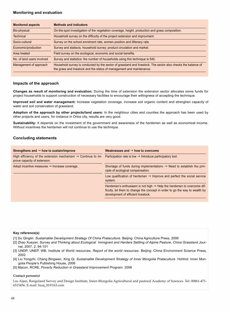
48
Monitoringandevaluation
Monitored aspects Methods and indicators
Bio-physical On-the-spot investigation of the vegetation coverage, height, production and grass composition.
Technical Household survey on the difficulty of the project extension and improvment.
Socio-cultural Survey on the school enrolment rate, women position and illiteracy rate.
Economic/production Survey and statiscis, household survey: product circulation and market.
Area treated Field survey on the ecological, economic and social benefits.
No. of land users involved Survey and statistics: the number of households using this technique is 540.
Management of approach Household survey is conducted by the sector of grassland and livestock. The sector also checks the balance of the grass and livestock and the status of management and maintenance.
Impacts of the approach
Changesasresultofmonitoringandevaluation:During the time of extension the extension sector allocates some funds for project households to support construction of necessary facilities to encourage their willingness of accepting the technique.
Improved soil and water management: Increase vegetation coverage, increase soil organic content and strenghen capacity of water and soil conservation of grassland.
Adoptionoftheapproachbyotherprojects/landusers: In the neighbour cities and counties the approach has been used by other projects and users, for instance in Ortos city, results are very good.
Sustainability: It depends on the investment of the government and awareness of the herdsmen as well as economical income. Without incentives the herdsmen will not continue to use the technique.
Concludingstatements
Strengthens and →howtosustain/improve
High efficiency of the extension mechanism → Continue to im-prove capacity of extension.
Adopt incentive measures → Increase coverage.
Weaknesses and → how to overcome
Participation rate is low → Introduce participatory tool.
Shortage of funds during implementationv → Need to establish the prin-ciple of ecological compensation.
Low qualification of herdsmen → Improve and perfect the social service system.
Herdsmen’s enthusiasm is not high → Help the herdsmen to overcome dif-ficulty, let them to change the concept in order to go the way to wealth by development of efficient livestock.
Key reference(s)[1] Du Qinglin. Sustainable Development Strategy Of China Prataculture. Beijing: China Agriculture Press, 2006[2] Zhao Xueyan. Survey and Thinking about Ecological Immigrant and Herders Settling of Alpine Pasture , China Grassland Jour-
nal, 2007, 2, 94-101[3] UNDP, UNEP, WB, Institute of World resources. Report of the world resources. Beijing: China Environment Science Press,
2002[4] Liu Yongzhi, Chang Bingwen, Xing Qi. Sustainable Development Strategy of Inner Mongolia Prataculture. Hohhot: Inner Mon-
golia People’s Publishing House, 2006[5] Macon, RCRE, Poverty Reduction in Grassland Improvement Program. 2006
Contact person(s)Liu Aijun, Rangeland Survey and Design Institute, Inner-Mongolia Agricultural and pastoral Academy of Sciences. Tel: 00861-471-6515456. E-mail: [email protected]

49
Left: The herder transports water for livestock by a tractor.Right: A pump operated by a windmill.Photo by Tu Ga
Location: Hexigten Banner of Chifeng City, Inner Mongolia Autonomous RegionTechnologyarea:10,000hm2 SWCmeasure:Management measuresLanduse: PastureClimate: Semi-arid continental climate WOCATdatabasereference: QTRelated approach: Extending Rotational graz-ing and Improving Rangeland ManagementCompiled by: Liu Aijun, Rangeland Survey and Design Institute, Inner-Mongolia Agricul-tural and pastoral Academy of SciencesDate: September, 2007
Editors’ comments: Hexigten Banner had initi-ated the projects of rotational grazing extensive-ly and highly leveled since 2002, which was a typical and well-tried demonstration of rotational grazing. Projects of rotational grazing are good examples for the improvements of pasturing ar-eas, and they are propitious to grassland protec-tion. Since then vegetation recovery of degraded grasslands have been realized, and obvious improvements of ecological environment and liv-ing conditions of herdsmen in project areas have been seen, and economic advantages for local herders, etc., have been felt.
Rotational Grazing Hexigten Banner of Inner Mongolia, China
Pasture is divided into several plots based on its productivity, and grazing period and grazing systems are fixed according to the carrying capacity of each plot.
The demonstration plots were identified at spring and autumn ranges in Jiri village and Hongqi village of Baiyinchagan township of Hexigten Banner of Inner Mongolia Autonomous Region. There around plots were rivers, lakes and residential areas, and grasslands degraded seriously because of tramples by livestock when drink-ing water. Perennial forages such as Leymus chinensis and Stipa disappeared in community, and many rangelands were dominated by Artemisia and forbs. Hexigten Banner initiated the project of rotational grazing in order to improve the living and production conditions of herdsmen, prompt reform of local production systems and preserve the ecological environment of grasslands. The main target of the project was to achieve the balance of pasture utilization, rational development of water re-sources, and eventually realize the balance between grass and livestock all the year through rotational grazing in summer and autumn and crops grown for silage, etc..
Project initiated in 2002, and central government allocated 8 million yuan as a spe-cial ear-marked funds . Total area of demonstration was 10,000 hm2 with 279 de-signed plots of 31 units.
Technical contents of rotational grazing mainly included: (1) Balance the utilization of rangelands through dividing the rangeland into units; (2) Solve the problem of wa-ter shortage by means of windmill, water tank and water transportation by tractors, etc;(3) Cultivate high-yielding forage crop at small scale with irrigation and fertilizer application; (4) Establish silage to supply forage all the year; (5) Strengthen control of diseases of livestock and improve rangeland management.
The problem of water shortage for livestock can be solved in the following ways: (1) To enclose an area within demonstration plot serving as water storage for live-stock under the conditions if there are river or lake available. (2) In the rolling areas, one drinking point should be created for two plots. Dig well near the pasture track, and every well was equipped with a windmill. A pitcher with capacity of 16 ton of water should be installed around each windmill. (3) If landform of plot is flat, the pitcher should be built at high terrace in favour of water flow in pipeline to grazing area.
3. IMPRO
VEM
ENT O
F DEG
RAD
ED G
RASSLA
ND

50
very steep (>60)steep (30–60)hilly (16–30)rolling (8–16)moderate (5–8)gentle (2–5)flat (0–2)
Growing season: 150d, (April to early September)Soil fertility: medium Soiltexture:medium (loamy texture) Surfacestoniness: scarce Topsoilorganicmatter:mediumSoil drainage: betterSoil erodibility: medium
>4000 >4000 3000–4000 3500–4000 2000–3000 3000–3500 1500–2000 2500–3000 1000–1500 2000–2500 750–1000 1500–2000 500–750 1000–1500 250–500 1000–500 <250 <500
Soil depth (cm)
0–20 20–50 50–80 80–120 >120
Classification
Landuseproblems- Grasslands degraded seriously, and perennial forages such as Leymus chinensis and Stipa disappeared. Many rangelands were dominated by Artemisia and forbs, and a part of pastures suffered from desertification.
Landuse Climate Degradation Measure
Over grazing Extensi- Semi-arid Vegetation Wind erosion Management ve pasture degradation measures
Technicalfunction/impactmain: - recovery of forage growth - increase of vegetation coverage - decrease of desertification - improvement of grassland productivity - sustainable use of resources
Environment
NaturalEnvironment
Averageannualrainfall(mm) Altitude(ma.s.l.) Landform Slope(%)
Landuserights:private Land ownership: collective ownership Market orientation: mixedLeveloftechnicalknowledgerequired:popularization operator: above media; land user: media Importance of off-farm income: less than 10%
Humanenvironment
Mixedlandperhousehold(hm2)
<1 1–2 2–5 5–15 15–50 50–100 100–500 500–1000 1000–10000 <10000
secondary: - improvement of knowledge of herdsmen and change of their traditional concept - generation of more income through changed mode of production - improvement of industrial structure
ridges
ridgeshill slopes
foot slopesvalley floors
mountain slopes
plains/plateaus

51
Technicaldrawing
Five barbed wire fences around rotational grazing units were used and the pil-lars of enclosures were made up of cements. Plots were divided by zinc coated fences, and added a barbed wire at the top of the fences. Gate of each plot was welded by steel pipes.
Three ways to solve the problem of live-stock drinking according to the practic-es: (1) In the units where rivers or lakes are in existence, livestock drinks water in a specially allocated public area using surface water. (2) In the areas of rolling terrain, one drinking point should be created for every two units. Dig wells in the plots near pasture track, and provided a windmill for each well. A water pitcher with capacity of 16 ton is installed close to each windmill and pasture track. Auto drinking trough was installed. (3) In the units with flat relief, settings of each pitcher were upraised and diverted water to the grazing plots by pipes. Total op-eration area was 10,000 hm2 according design.
Implementationactivities,inputsandcosts
Establishmentinputsandcostsperhm2
Inputs Costs(US$) %metbylanduser
Labour 12 0
Equipment
- tractors, shovels, etc. 40 0
Materials
- mechanical enclosures, water 46 0 equippments, etc.
Agricultural
- seeds, fertilizer, pesticides, etc. 13 0
TOTAL 111 0
Establishment activities1. Planning design themes and building drawings.2. Establishing enclosures, which included 31 units and 278 plots; 15 pasture tracks and each was 12 m in width.3. Digging wells and fitting windmills for water.4. Developing high yielding forage basis.
Project initiated in 2002 and lasted for 5 years.
Remarks: Project households would afford the management costs, and there were no fixed costs of maintenance and labor hours. So it was different to calculate maintenance cost. Results in this table were survey data, instead of calculated results by some standards.
Maintenance/recurrentactivities1. Enclosure mending.2. Machine services and related cost is at expense of the project households.3. Land arrangement: Forage basis were leveled ground and sowed by project housh-olders as spring drew near. Non-mechanized operations would be adopted because of small working areas.The sustainability and demonstration effects of projects should be ensured by enclosure mending, machines protect-ing, land arrangement, etc, when the project areas were built.
Maintenance/recurrentinputsandcostsperhm2 per year
Inputs Costs(US$) %metbylanduser
Labour 0.3 100
Equipment 0.5 100
Materials 0.1 100
Agricultural
TOTAL 0.9 100
3. IMPRO
VEM
ENT O
F DEG
RAD
ED G
RASSLA
ND

52
Strengthens and →howtosustain/improve
Over grazing was controlled and was in favour of pasture recovery → Keep on popularization.
Industrial structure and economic advantages were improved → Intensify livestock improvement and increase the individual merit. Circulation chan-nel and slaughtering rate should be further strengthened.
Improvement of ecological environment and infrastructure in pastoral re-gions → Increasing more inputs to infrastructure, and increase more public sources for pastoral regions, such as electricity, traffic, communication, education and medical care, etc.
Weaknesses and → how to overcome
Contradiction between rotational grazing and increasing in-comes → Intensify financial supports and credit.
Technological services could not meet the demands → Perfect technical service system of community.
Irrational structure of livestock herds and inef-ficiency of livestock improvement
Misact ion of balance system between grass and livestock
Increased economic burdens for herdsmen and labor intensity
Key reference(s)[1] Du Qinglin. Sustainable Development Strategy of China Prataculture. China Agriculture Press, 2006[2] UNDP, WB, WORLD RESOURCES INSTITUTE. WORLD RESOURCES REPORT, Beijing: China Environmental Science Press, 2002[3] Macon, RCRE, Poverty Reduction in Grassland Improvement Program, 2006[4] Zhao Heping, To implement system of suspend grazing, forbiden grazing and rotational grazing aimed to realize sustainable
development of grasslan, Proceedings of Forum on Sustainable Development of Prataculure in China, 285-288[5] Liu Yongzhi, Chang Bingwen, Xing Qi. Sustainable Development Strategy of Inner Mongolia Prataculture. Hohhot: Inner Mon-
golia People’s Publishing House, 2006
Contact person(s)Liu Aijun, Rangeland Survey and Design Institute, Inner-Mongolia Agricultural and pastoral Academy of Sciences. Tel: 13521029360. E-mail: [email protected]
Assessment
Acceptance/adoption
Benefits/costsaccordingtolanduser Benefitscomparedwithcosts Short-term Long-term
establishment active active
maintenance/recurrent active active
Impacts of the technology
Productionandsocio-economicbenefits Productionandsocio-economicdisadvantages
+ + + Livestock gained weight – – –
+ + + Production methods of animal husbandury optimized and – – – herdsmen’s income increased
+ + Saved labor was transferred to second and third industries – –
Socio-culturalbenefits Socio-culturaldisadvantages
+ + + Scientific technologies were improved and herdsmen’s – – Less chance for women’s involvement traditional concept changed
Ecologicalbenefits Ecologicaldisadvantages
+ + + Pabular forages and grass coverage increased None
+ + + Grazing intensity were lessened
+ + Water and soil conservation were strengthened
+ + Degradation was halted
Off-sitebenefits Off-sitedisadvantages
+ + + Climate of sandy storm was lightened None
Concludingstatements

53
Extending Rotational Grazing and Improving Rangeland ManagementHexigten Banner of Inner Mongolia, China
Rangelands are divided into several plots, which are used in a balanced rotational way for livestock. It provides an opportunity of rehabilitation of rangelands and fa-vours rational use.
Hexigten Banner, located in northeast of Chifeng City on the south edge of Dax-ing’anling Mountain, is adjacent to Otindag Sandy Land. It is an animal husbandry-centered banner. Due to overgrazing, degradation of grassland and decreased pro-ductivity, the central government decided to encourage suspend grazing and use rotational grazing with a subsidy in cash and food. Rotational grazing has promoted vegetation recovery, ecological environment improvement and poverty reduction.
The project started at 2002. Due to support, provided by the Ministry of Agriculture and Department of Animal Husbandry of Inner Mongolia, and assistance, given by Inner Mongolia Institute of Grassland Survey and Design, Animal Husbandry Bureau of Chifeng City and Animal Husbandry Bureau of the Banner, the project covering 10,000 hm2 has achieved an outstanding success during 2 years. The project funds, which came from budget of central government as ear-marked funds, have been used for establishment of infrastructure, including enclosure and drinking facilities. The funds raised by herdsmen are used mainly for purchasing production facilities and daily necessities.
In order to better manage project the government of the Banner has set a Leader-ship Group with the Banner leader as the leader of the group. The leaders of rele-vant sectors are the members of the group. The Bureau of Animal Husbandry of the Banner is in charge of routine operation. The Bureau of Animal Husbandry of the Banner has formulated management regulations, which clearly define ownership. Responsibilities of management and maintenance have been specified in contract. Every household has its obligations for managing its grazing units, including mainte-nance and possible repairing work of enclosures. Every unit must appoint a person for overall supervision and coordination. The Grassland Supervision Office of the Banner is responsible for check of carrying capacity. Any overgrazing and excessive use of pasture land is forbidden.
At present, total area of natural rangeland under rotational grazing amounts to 4.6 million hm2 in Inner Mongolia autonomous Region. As monitoring results indicate, that vegetation coverage and production is increased by more than 30%, and carry-ing capacity is increased by 15% due to rotational grazing, The degraded rangelands have signs of positive succession. The ecological environment of pasture land is im-proved and incomes of herdsmen increased.
Left: Plots of rotational grazing in Hexigten banner.Right: Construction and management in rota-tional grazing plots.Photo by Tu Ga
Location: Hexigten Banner of Chifeng City, Inner Mongolia Landuse: Pasture land Climate: Semi-arid WOCATdatabasereference:QARelated technology: Rotational Grazing Compiled by: Liu Aijun, Rangeland Sur-vey and Design Institute, Inner-Mongolia Agricultural and pastoral Academy of Sci-encesDate: September, 2007
Editors’ comments: Ecological compensa-tion is an important measure both in improv-ing incomes for farmers and herdsmen and economic development of steppe zones. The precondition of rotational grazing is the guar-anteed survival right and development right of herdsmen. The project can be sustainable only when herdsmen have more generated income and local economy has continued de-velopment.
3. IMPRO
VEM
ENT O
F DEG
RAD
ED G
RASSLA
ND

54
Problem, objectives and constraints
Problem- A gap exists between recognized importance of rotational grazing by herdsmen and its overall extension.- Methodology cannot be operational without adequate financing, and training is also important. - The long term compensation and incentive mechanism is the key of technical application.
Objectives- To establish effective mechanism of technical extension.- To improve awareness of ecological protection in communities.- To increase participation of communities.- To solve the contradiction between limited rangeland and growing demand of animal husbandry.- To improve the production environment, protect and recover vegetation.- To increase the contribution rate of scientific progress and innovation of science and technology to ecological management.
Major Specification
Economic aspect Large investment at the initial stage and high cost of management are the heavy burden for herdsmen, moreover, the income generated by herdsmen decreased in short time.
Social aspect Rotational grazing is not a commonly acceptable grazing system, and most herdsmen, having traditional free grazing habits, feel difficult to change their concepts.
Minor Specification
Technological aspect As herdsmen lack knowledge of animal management, and it is not easy to popularize the technology through out pastoral regions.
Treatment
Government provides financial support and preferential policy to herdsmen and awards and incentives to project households.
Strictly follow the system of a balance between rangeland and livestock. To this end, it is necessary to speed up livesock improvement, increase production performance and profits, strengthen publicity and improve awareness of herdsmen with an aim to reduce animal heads and increase income.
Treatment
Technical training should be strengthened and social service system in pastoral region will be established and perfected.
Constraints addressed
Differences in participation of men and women: Grazing works were generally assumed by men before rotational grazing imple-mented. After rotational grazing implemented, women instead of men were responsible for the task of feeding, drinking, delivering lamb, chopping grass and milking, etc. Even summer grazing were undertook by women. Women assumed responsibility for almost all the housework in their families.
Participation and decision making
Targetgroups
Land user Decision maker Land planner SWC Experts
Decisions on choice of the technology: This technology will be provided by rangeland experts. Decisions on method of implementing the technology: It is implemented by the Banner Animal Husbandry Bureau, and the technical extension institution is in charge of design and providing technical operation to herdsmen in the field. Approach designed by: Operation design will be provided by national or provincial experts, and land users participate in adaptation.
Communityinvolvement
Phase Involvement Activities
Initiation Passive Delegates of herdsmen, directors of villages or groups and some herdsmen participated in the activities of information consultations and questionnaire survey.
Planning Interactive Herdsmen participated in the selection of project area and demarcation of the range area and livestock scales of rotational grazing.
Implementation Interactive Community and people who are relevant to profits, participated in the consultations and discussions, and staff are organized for implementation according to plan; in the mean time they put forward their improved opinions.
Monitoring/evaluation Participated Herdsmen monitored the conditions of rangeland health and livestock production under the directions of technicians.
Research Did not participate Herdsmen scarcely participated in the scientific research works of rotational grazing.
Approach costs met by
State investment 50%
Local funds 50%
Total 100%

55
Organogram
Management and implementation of the project were conducted up and down. Firstly the national administration puts forward a project plan, and subsequently the plan went forth to provincelevel man-agement departments. Project with funds finally reached banners and countries. Banners and counties are responsible for design, setting up management commit-tee and bid invitation. As a last step, the project must be implemented on concrete places and households.
Communities,Project Householders
Ministry of Agriculture of China, Development and Reform Commission
Agriculture & Animal Husbandury Department of IMAR,Development and Reform Commission
County-level Bureau of Animal Husbundary, Bureau of Grassland Monitoring and Management
General D
esign
Technical Manage-
ment
Implem
entaryO
peration
Enginneering
design
Bid Invitation
Enginneering
Supervision
Audit and
Statistics
Equippm
entP
urchase
Equippm
entD
ebugging
FinancialM
anagement
Extension and promotion
Training: Technicians assigned by province provided free-of-charge trainings, through which herdsmen could learn the rules of rota-tional grazing. In average, one person from each household was trained in the forms of textbooks, information booklets, TV media, door-to-door interviews with households, etc. Validation of training was good for technicians and was medium for herdsmen.
Extension: Extension mainly was conducted by provincial and local technical sectors. Provincial sector was responsible for the project design, and project groups of Banners (Counties) were responsible for implementation. At present, the demonstration results were quite good, but herdsmen had no willingness to use rotational grazing, because of the huge investment at early stage. There-fore, method of rotational grazing will be used widely by herdsmen, if governments provide more inputs.
Research: It included livestock nutrition, adjustment balance of grass and livestock, and grassland monitoring and evaluation, etc.
Importanceoflanduserights:There was no significant impact of land use right on project implementation.
Incentives
Labour:Volunteer labour inputs by herdsmen.
Inputs:Government provided the costs of infrastructure construction, which were used for purchasing enclosures, angle irons, dig-ging wells, windmills, livestock improvement and disease control, etc.
Credit: Banks provided interest-free of low-interest loans.
Supportoflocalinstitutions: The implementation of projects promoted capacity building, because project brought funds and tech-nology.
Long-term impact of incentives: Long-term impacts would be positive, but reduced input by government might have impact on popularization of rotational grazing. Demonstration zone played a strong role in popularization. It is believed that this method of ratio-nal grazing, as a scientific system of grassland utilization would be finally accepted by herdsmen with their improved awareness and knowledge on rotational grazing.
3. IMPRO
VEM
ENT O
F DEG
RAD
ED G
RASSLA
ND

56
Monitoringandevaluation
Monitored aspects Methods and indicators
Bio-physical Field monitoring and investigation: forage coverage, height, species and productivity of available forages.
Technical Investigation: number, weight of livestock, carrying capacities and forage yields.
Socio-cultural Questionnaire: household survey. Items included enrolment rate for children, proportion of students entering schools of a higher grade, educational costs, etc. Cultural activities of communities were also included.
Economic/production Statistical survey, monitoring and census: forage yield, herdsmen incomes.
Area treated Field investigation. Areas of rotational grazing were statistically used.
No. of land users involved Statistical survey indicated: 15 households accepted the technology of rotational grazing.
Management of approach Household investigations were undertaken by grass-root supervision sector of grassland. The task was to check balance of grass and livestock and project management and maintenance.
Impacts of the approach
Changesasresultofmonitoringandevaluation:Training forms were various. Some foreign projects conducted trainings, which could provide costs and training venues. Most women actively participated in the trainings. Scientific and technological abilities of herds-men were increased, and some traditional concepts were changed. It greatly changed the modes of animal husbandry production.
Improved soil and water management: Water and land resources were rationally used. Rangeland condition and soil organic matter were improved. Moisture-holding capacity of grassland was enhanced.
Adoptionoftheapproachbyotherprojects/landusers:Project was demonstrated in ten Leagues (cities) and 36 Banners (counties). Rotational grazing areas popularized by grassland design departments of Inner Mongolia reached 10,045,00 mu (1 hm2 =15 mu). Beijing-Tianjin Sand Control Programme and the Programme of Conversion of Grazing Area to Grassland have adopted the tech-nology of rotational grazing.
Sustainability:Application of rotational grazing technology was guided by government investment, and willingness of herdsmen to pay increased from 100 yuan to a 1000 yuan. Some herdsmen were willing to pay match funds with government in 5%-10%. Herds-men should be the main body of investment and construction from a long-term point of view; however, herdsmen would not apply the technology of rotational grazing consciously in near future, if there were no incentives or projects supports.
Concludingstatements
Strengthens and →howtosustain/improve
High efficiency of popularization → Abilities of extension depart-ment should be further improved.
Encouragement measures should be adopted → Enlarging the demonstration areas.
Rotational grazing with lease-holding household groups adopted → Further Improved rotational grazing mechanism with lease-holding household groups.
Weaknesses and → how to overcome
Economic burdens of herdsmen were increased → More inputs should be increased and encourage herdsmen to make more inpus.
Backward in technologies and services → Services of science and tech-nology should be reformed and social service system in pastoral region should be further improved.
Women had less chance for participation → Participatory approach should be adopted.
Low education level of herdsmen → Strengthening training and education to change traditional concepts of management.
Key reference(s)[1] Du Qinglin. Sustainable Development Strategy Of China Prataculture. Beijing: China Agriculture Press, 2006[2] Zhao Xueyan. Survey and Thinking about Ecological Immigrant and Herders Settling of Alpine Pasture , China Grassland Jour-
nal, 2007, 2, 94-101[3] UNDP, WB, WORLD RESOURCES INSTITUTE. WORLD RESOURCES REPORT, Beijing: China Environmental Science Press, 2002[4] Liu Yongzhi, Chang Bingwen, Xing Qi. Sustainable Development Strategy Of Inner Mongolia Prataculture. Hohhot: Inner Mon-
golia People’s Publishing House, 2006[5] Macon, RCRE, Poverty Reduction in Grassland Improvement Program. 2006
Contact person(s)Liu Aijun, Rangeland Survey and Design Institute, Inner-Mongolia Agricultural and pastoral Academy of Sciences. Tel: 13521029360. Email: [email protected]

57
Silt Storage Dam Yulin County of Shaanxi Province, China
Silt storage dam is a kind of building, which is constructed at all levels of channels in areas with soil and water loss for forming farmland.
Silt storage dam, also called as production dam, is a special and unique gully control project in area with serious soil and water loss in the Loess Plateau. The demonstra-tion site, located in Yulin County, Shaanxi Province of China, belongs to Loess Hilly-gully Region with temperate continental monsoon climate. The amount of average annual rainfall is 480 mm. The maximum amount of Soil erosion modulus is 15000t/km2·a. The land use type is farmland.
Silt storage dam structure: Large dam consists of dam, sluice tunnel, spillway. Medi-um-small dam consists of dam and spillway. There are three kinds of dam in demon-stration area: small dam with control area of less than 0.5km2, medium dam 0.5-3km2 and the key project 3-10km2.
Construction process: Site selection and topographic map measurement; design (hy-drologic computation, dam height determination, dam section determination, size of discharge building).
Construction: Rolled earth dam construction. First: alignment, Second: dam founda-tion and bank slope treatment; Third: Dam filling; (1) soil material selection; (2) pave the soil; (3) compaction (stratified compaction, depth is less than 20 cm).
Hydraulic filling dam. First: water storage. (1) base flow accumulation; (2) hold sea-sonal flood water; (3) hold ice water; (4) upstream running water; (5) reserve water by water storage dam heightening; (6)shift water from neighbour channel. Second: Earth pits selection. nearby the filling body, 20-30cm higher than the filling body; The soil with lower clay content. Third: construction site layout. (1) earth pits layout; (2) layout of mudmaking ditch and mudtransport; (3) road layout; Forth: pump station construction. (1) station site selection; (2) pump selection; Fifth: field division and earth dike construction. (1) field division; (2) earth dike construction; Sixth: mudmak-ing and filling; Seventh: drainage; Eighth: top capping; Ninth: dam body clearance.
Maintenance: (1) Daily maintenance includes: keeping dam crest and dam slope complete. (2) Crack maintenance includes: excavation and earth-fill method and grouting method. (3) Leakage maintenance includes throwing earth method, grout-ing method, clay covering method and so on. (4) Landslide maintenance includes: excavation and earth-fill method, dam slope mitigation and seeping convention by trenching method.
Left: Downstream slope of medium-size damRight: Medium-size dam without spillwayPhoto by Wang Yongjun
Location: Yulin County, Shaanxi ProvinceTechnologyarea: 75km2
SWCmeasure: Mechanical practiceLanduse:OthersClimate: Semi-arid WOCATdatabasereference:QTRelated approach: Silt Storage Dam for Forming Farmland Compiled by: Wang Yongjun, Qi Shi, Institute of Soil and Water Conservation, Beijing For-estry UniversityDate: September, 2007
Editors’ comments: Desilting dam is a main measure to treat small watershed channels. Its function: sediment storage; prevent val-ley trenching; prevent banks wider; control channel gravitational erosion; adjust channel runoff; utilize water sources rationally; relief channel and reservoir sedimentation; improve basin environment; develop rural economy. Desilting dam construction in the Loess Pla-teau becomes an important component of lo-cal farmland construction.
4. WA
TER AN
D SO
IL CO
NSERVA
TION
MEA
SURES

58
very steep (>60)steep (30–60)hilly (16–30)rolling (8–16)moderate (5–8)gentle (2–5)flat (0–2)
Growing season: 185 days(from April to September) Soil fertility: low Soiltexture:medium (loam)Surfacestoniness: NA Topsoilorganicmatter:low Soil drainage: goodSoil erodibility: very high
>4000 >4000 3000–4000 3500–4000 2000–3000 3000–3500 1500–2000 2500–3000 1000–1500 2000–2500 750–1000 1500–2000 500–750 1000–1500 250–500 1000–500 <250 <500
Soil depth (cm)
0–20 20–50 50–80 80–120 >120
Classification
LanduseproblemsArid climate, rainstorms, serious soil and water loss; Organic matter layer has been peeled off and eroded, soil impoverishment; Veg-etation coverage is low, vegetation is in poor growth.
Landuse Climate Degradation SWCmeasure
Semi-arid Water erosion
Technicalfunction/impactmain: - holding sediment, reduce the amount of sediment rushed into the Yellow River - silt storage forming new farmland - flood control and disaster reduction to protect downstream - raise the effective utilization rate of rainfall resources - relief pressure of water deficit for production, livelihood and ecological use
Environment
NaturalEnvironment
Averageannualrainfall(mm) Altitude(ma.s.l.) Landform Slope(%)
Farmland Agroforest Vegetation destruction
Wind erosion Mechanical measure
Biological measure
Landuserights:private Land ownership: state Market orientation: mixed Leveloftechnicalknowledgerequired:technician: high; land user: low Importance of off-farm income: 10%-50% of the total income
Humanenvironment
Mixedlandperhousehold(hm2)
<1 1–2 2–5 5–15 15–50 50–100 100–500 500–1000 1000–10000 >10000
secondary: - use dam as road to improve transportation condition - improve living condition - promote the construction of the new rural area - promote the development of the rural economy
ridges
ridgeshill slopes
foot slopesvalley floors
mountain slopes
plains/plateaus

59
Technicaldrawing
Dam site cross-section is measured. Layout plan is measured 1:500 topo-graphic map. It contains three borrow earth pits. Seen from the dam cross-section, there is a berm. Connecting slot is constructed under the dam.
Drawing by Wang Yongjun, Qi Shi
Implementationactivities,inputsandcosts
Establishmentinputsandcostsperhm2
Inputs Costs(US$) %metbylanduser
Labour 12000 0
Equipment/tools
- 74kW bulldozer 5000 0
Materials
- earth material 15000 0- loose-stone 2500- precast concrete 4000
Agricultural
- planting grass on downstream slope 600 0
TOTAL 38500 0
Establishment activities1. Local borrow selection(avoid destructing vegetation).2. Slope cutting (make borrow slope smaller than safety gradi-ent) ; Stone bank slope less than 1:0.6; Earth bank slope less than 1:1.5; Slope must not be cutted into step.3. Pave soil(rolled depth should be less than 20cm by labor and less than 25cm by caterpillar).4. Compaction.5. The construction period of earth dam lasts about 1 year.
Remarks: The construction expenses of silt storage dam contain: construction material, labor, mechanic and independent cost and contingent fund. Computation of these expenses is based on the material price of the same year. Maintenance cost is determined according to the local labor price. Exchange rate: 8.278.
Maintenance/recurrentactivities1. Supervision. 2. Fix damaged dam, earth filling.3. Maintenance of offlet, artificial patrol: check whether offlet is blocked or damaged. Clear up it and repair it in time to en-sure normal use during the rainy season.4. Dam body Maintenance: Prevent the damage caused by rainstorm erosion during the rainy season. Patrol and mend in time if damaged.
Maintenance/recurrentinputsandcostsperhm2 per year
Inputs Costs(US$) %metbylanduser
Labour 30-60 30
Equipment
- shovel 5-10 100
Materials
- earth material 15-30 30- stone 15-60 0
Agricultural
- vegetation Maintenance for 10-15 100 slope protection
TOTAL 75-175 52
Dam site cross-section
Layoutplan
Dam cross-section
deposition elevation 1260.5
maximum flood level 1267.0
1272.51267.51262.51257.51252.51247.51242.5
peg
numb
er el
evation
0+
015
1260
.42
0+
000
1242
.6
0+
007
1242
.5
0+
015
1244
.26
0+
019
1245
.5
0+02
2 12
46.3
0+
032
1250
.83
0+
050
1254
.55
0+
062
1258
.34
0+
084
1259
.89
0+
101
1255
.46
0+1
08.5
125
0.46
0+1
13.5
125
0.46
0+
121
1250
.60
0+
126
1255
.64
0+
139
1260
.32
inlet elevation of culvert pipe 1253.1
crest elevation 1268.5
elevation of gullybottom 1242.5
outlet elevation of culvertpipe 1252.3
drainage body
borrow pit
borrow pit
borrow pit1268.50 crest elevation
1267.0 flood detention elevationleft bank
dam baseline
H(m)
right bank1260.60 deposition elevation
1 : 2.0
150mm(bern)
400mm
4000
12500
100100
100
1 : 2.0
1 : 2.5
1253.1 inlet elevation of culvert pipe
cope level of invertedfilter 1246.1
4. WA
TER AN
D SO
IL CO
NSERVA
TION
MEA
SURES

60
Key reference(s) Fan Ruiyu. Ecological engineering of Loess Plateau Dam system. Zhengzhou: Yellow River Water Conservancy Publishing House, 2004
Contact person(s) Wang Yongjun, Institute of Soil and Water Conservation, Beijing Forestry University. Email: [email protected]
Strengthens and →howtosustain/improve
Combining slope and channel treatment to prevent soil and water loss → Com-bining engineering and biological measures, develop comprehensive treatment .
Reducing and preventing channel erosion → Continuing silt storage dam project.
Increasing availability of rainfall resource → Conducting a study on dry farming and technical extension.
Weaknesses and → how to overcome
High cost → Creation of multiple investment mechanism.
Disjunction among construction, management and use exists in the dam construction management → Clearly define ownership and carry out the principle of unified “responsibility, right and benefit”.
Assessment
Acceptance/adoption- Most of the land users accept the construction and maintenance of silt storage dam. - With the incentive mechanism, 98% of farmers have a willingness of participation in dam construction. - While without incentive mechanism, some 80% of farmers can accept.
Benefits/costsaccordingtolanduser Benefits/costsratio Short-term Long-term
establishment very positive very positive
maintenance/recurrent very positive neutrality
Impacts of the technology
Productionandsocio-economicbenefits Productionandsocio-economicdisadvantages
+ + + Increasing cultivated area, improve grain yield None
+ + + Improving availability of rainfall resource
+ + Mitigating shortage of water use(for life, production, ecology)
+ + Helpful to fishery breeding
Socio-culturalbenefits Socio-culturaldisadvantages
+ Strenthen capacity buildin of the construction and None soil & water conservation departments
+ Improving knowledge of farmers on soil and water conservation
Ecologicalbenefits Ecologicaldisadvantages
+ + + Blocking sediment and storing soil, thus reducing sediment – Dam construction may destroy surrounding of the Yellow River environment and increase soil and water loss
+ + + Raising erosion basis, keeping gully slope stable
+ + + Flood control and disaster reduction, protect safety of the downstream area
+ + Improving regional environment
Off-sitebenefits Off-sitedisadvantages
+ + Reduce downstream flood and channel sedimentation – Reduction of runoff of downstream river
Concludingstatements
At initial stage, dam construction took up farm land, thus farmers’ income is decreased and cost increased temporally. After dam built-up, farmers could develop aquiculture or irrigation.

61
Silt Storage Dam for Forming Farmland Yulin County of Shaanxi Province, China
Silt storage dam is a kind of building, which is constructed at all levels of channels in soil and water erosion areas for forming farmland. The farmland made in this way is called dam land.
Silt storage dam, as an effective engineering measure for soil and water conserva-tion and reducing sediment of the lower reach of the Yellow River, is a project which is invested by government, designed and extended by water conservation depart-ment and implemented by enterprises.
The Silt storage dam for forming farmland is built by four steps: (1) project applica-tion; (2) feasibility study of Dam system; (3) primary design; and (4) implementation.
The invitation for bid is a way of project implementation and the construction unit se-lected for implementation shouldhave qualification and high prestige. The following issues should be emphasised during the project implementation: (1) examination of construction company qualification; (2) quality of construction materials; (3) quality supervision during the construction; (4) middle stage acceptance check; (5) supervi-sion of construction methods and technology.
The ways of silt storage dam popularization are as follows: firstly, it can be extended from pilot site to other area by demonstration; secondly, let local government and land users realize the benefits of silt storage dam by different media, so as to pro-mote the development of dam construction; thirdly, encouraging the local govern-ment and land users actively to build silt storage dam by taking all kinds of incentive measures, particularly cash payment, and supplementary measures, including prior-ity of accessing and contracting the dam land.
During construction of silt storage dam, land users can obtain cash for work. The participation of land users not only promotes development of silting dam, but also solves the problems caused by land use right.
The main approach of dam construction can be expressed as: government plays a leading role with support from local departments; enterprises are responsible for im-plementation and farmers take part in construction.
The silt storage dam system can improve environment of project area, promote the economic development, increase the forest and grass cover, the amount of storage and infiltration of rainfall, reduce flood and converse slope farmland to forest and grass in favour of economic development of the basin.
Left: Silt storage dam under construction.Right: Silt storage dam after construction.Photo by Wang Yongjun
Location: Yulin County, Shaanxi ProvinceLanduse: OthersClimate: Semi-arid WOCATdatabasereference:QARelated technology: Silt Storage Dam Compiled by: Wang Yongjun, Qi Shi, Institute of Soil and Water Conservation, Beijing For-estry UniversityDate: September, 2007
Editors’ comments: Gully treatment is an im-portant component of ecological construction in the Loess Plateau. This implementation method is popularized by demonstration. The main approach of construction of silt storage dam is as follows: government plays a leading role with support from local departments; en-terprises are responsible for implementation and farmers take part in construction. This method is widely adopted in Loess Plateau and Northern China.
4. WA
TER AN
D SO
IL CO
NSERVA
TION
MEA
SURES
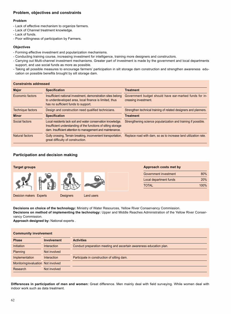
62
Problem, objectives and constraints
Problem- Lack of effective mechanism to organize farmers. - Lack of Channel treatment knowledge.- Lack of funds.- Poor willingness of participation by Farmers.
Objectives- Forming effective investment and popularization mechanisms. - Conducting training course, increasing investment for intelligence, training more designers and constructors.- Carrying out Multi-channel investment mechanisms. Greater part of investment is made by the government and local departments
support, and use social funds as more as possible. - Taking all possible measures to encourage farmers’ participation in silt storage dam construction and strengthen awareness edu-
cation on possible benefits brought by silt storage dam.
Major Specification
Economic factors Insufficient national investment, demonstration sites belong to underdeveloped area, local finance is limited, thus has no sufficient funds to support.
Technique factors Design and construction need qualified technicians.
Minor Specification
Social factors Local residents lack soil and water conservation knowledge. Insufficient understanding of the functions of silting storage dam. Insufficient attention to management and maintenance.
Natural factors Gully crossing, Terrain breaking, inconvenient transportation, great difficulty of construction.
Treatment
Government budget should have ear-marked funds for in-creasing investment.
Strengthen technical training of related designers and planners.
Treatment
Strengthening science popularization and training if possible.
Replace road with dam, so as to increase land utilization rate.
Constraints addressed
Differences in participation of men and women: Great difference. Men mainly deal with field surveying. While women deal with indoor work such as data treatment.
Participation and decision making
Targetgroups
Desicion makers Experts Designers Land users
Decisions on choice of the technology: Ministry of Water Resources, Yellow River Conservancy Commission. Decisions on method of implementing the technology: Upper and Middle Reaches Administration of the Yellow River Conser-vancy Commission. Approach designed by: National experts .
Communityinvolvement
Phase Involvement Activities
Initiation Interaction Conduct preparation meeting and ascertain awareness education plan.
Planning Not involved
Implementation Interaction Participate in construction of silting dam.
Monitoring/evaluation Not involved
Research Not involved
Approach costs met by
Government investment 80%
Local department funds 20%
TOTAL 100%

63
Extension and promotion
Training: Training subjects: design and planning and daily maintenance of silt storage dam; flood control and ensuring harvest, planting in dam land. Training types: training course, seminar, guidelines book. Training results: good results for Designers and fair results for local farmers.
Extension: Silt storage dam construction technology contains: rolled fill and sluicing-siltation damming techniques. The extension depends on government, and driven by demonstration. Main institutions: local government, soil and water conservation station. How-ever, lack of funds will affect the extension.
Research: Main programs: Research on sediment reduction controlling model in the main sources of Yellow River coarse sediment, which includes: Soil erosion law of coarse sediment sources; Study on allocation model of control measures; Study on distribution pattern of channel dam system. Study on sustainable utilization of water resources, which includes: Water resources evaluation; Study on natural rainfall collection technology; Study on flood resource utilization; Optimal allocation of water resource.
Importanceoflanduserights:Property Right is not clear and it affects project implementation.
Incentives
Labour:The labour is recruited with cash payment.
Inputs:Government investment, Local department support. Other inputs such as soil material, stone, steel bar, cement, diesel oil, tractors, bulldozers, tree seedlings, fry and so on are needed in addition to funds.
Credit: Government investment and local department funds without credit.
Supportoflocalinstitutions: For the design and construction of silt storage dam, local soil and water conservation stations can get financial benefits from national government investment on one hand, and by, it also improves capability of the local soil and water conservation departments through training , seminar and technical meeting on the other hand.
Long-term impact of incentives: Incentives can ensure successful accomplishment and operation of silt storage dam. Because of the time limits of the use right of silt storage dam, it is difficult for farmers to maintain the dam over a long period of time, so there is a risk for future operations of the dam. If the responsibility, power and interest can be reasonably guaranteed, farmers will maintain the dams positively, even no incentives be provided.
Organogram
Materials supply: The bureau of supervi-sion of Yellow River soil and water con-servation of Suide.
Drawing: Wang Yongjun, Qi Shi
Ministry of Water Resources
The Yellow River WaterConservancy Committee
Bureau of Administration of the Upper-Middle Reaches of the Yellow River
The soil and Water Conservation Division, Department of Water Resources,Shaanxi
Soil and Water Conservation Station of Suide County
The Bureau of Supervision of Yellow River Soil and Water Conservation of Suide
Design Institution ConstructionCompany
SupervisionInstitution
Land User
4. WA
TER AN
D SO
IL CO
NSERVA
TION
MEA
SURES

64
Monitoringandevaluation
Key reference(s) [1] Fan Ruiyu, Dam system ecological engineering of Loess Plateau. Zhengzhou: Yellow River Water Conservancy Publishing
House, 2004[2] Bureau of administration of the upper-middle reaches of the Yellow River. Experimental study on silt storage dam. Beijing: Chi-
na Plan Publish House, 2005
Contact person(s)Wang Yongjun, Institute of Soil and Water Conservation, Beijing Forestry University. Email: [email protected]
Methods and indicators
Methods: measurement; investigation; setting monitoring plots.Indicators: detention volume; rainfall; erosion; dam reservoir deposition.
Methods: investigation.Indicators: dam leakage; landslide; crack; preservation degree and damages of water discharge buildings.
Methods: sampling survey in residential area; questionnaire of workers.Indicators: degrees of approval of Debris flow protection importance, action performance.
Methods: random investigation.Indicators: input-output; yield increasing benefit; protection input; engle’s coefficient.
Methods: sampling survey.Indicators: change of area of land forming and vegetation area.
Household survey.
Methods: questionnaire; household survey.Indicators: satisfaction to the silt storage dam; satisfaction to the constructors’ working attitude.
Monitored aspects
Bio-physical
Technical
Socio-cultural
Economic/production
Area treated
No. of land users involved
Management of approach
Strengthens and →howtosustain/improve
Top-down model, efficient extension system → Extend dam system construction in large-scale.
Intercepting sediment efficiently, reducing gully erosion, pro-vide better conditions for improving basic farmland → Develop-ing aquiculture and economic forest.
Increasing farmland area → Combining treatment with devel-opment to push techniques application.
Demonstration driving, Plot-local radiation → Take full attention of extension, improve radiant area as possible.
Weaknesses and → how to overcome
Lack of national investmnet → Allocate special funds; Strenthen investment and construction; Achieve diversified Investment.
Property right and responsibility of dam land are not clear → Defining prop-erty rights and it’s ownership; Guarantee the sustainable development of silt storage dam.
Extension system is not perfect, and it mainly relies on national, local gov-ernment and soil and water conservation department → Establishing and perfecting extension system, setting up technical extension department to guarantee the extension in time and effectively.
Impacts of the approach
Changesasresultofmonitoringandevaluation:Extension method has great changes. It shows as follows: firstly, getting rid of traditional extension of national mandatory; secondly, achieving multiple investments; thirdly, the dam system has become an important component of local ecological development.
Improved soil and water management: Increasing the availability of rainfall resources; mitigating the pressure of water supply for production, living and ecology; decreasing the sediment into the Yellow River; increasing the arable land area and raising the yield production; promoting conversion of slope farmland to forest and grassland; reducing slope vegetation destruction.
Adoptionoftheapproachbyotherprojects/landusers:Silt storage dam has been extended to Shanxi, Ningxia, Qinghai, and Henan Provinces.
Sustainability:As the high cost of silt storage dam and relatively slow returns, land users have difficulty to afford the high con-struction cost of the dam without government support.
Concludingstatements

65
Check Dam Xifeng County of Gansu Province, China
Check dam is a kind of sediment storage dam of 5m below and is built in channels to control the down cutting of channel bed.
The technical demonstration site is located at the Loess plateau with continental monsoon climate, drought and less rain in winter and spring, moderate rainfall in summer and autumn. The amount of average annual rainfall is 556.5 mm and the amount of water surface evaporation is 1491.0 mm. The average frost-free period is155 days, soil types are Heilu soil, loessal soil and alluvial soil. Medium soil fertil-ity which is suitable for growing forest and grass. Runoff modulus is 8894 m3/a·km2, erosion modulus is 4350 t/km2·a. The amount of surface runoff of Yuan tableland ac-counts for 67.4 percent of the total watershed and sediment accounts for 12.3% of the total.
According to the materials, the check dam types are earth check dam, stone check dam, stone loaded by bamboo cylinder check dam, concrete check dam, biological check dam etc..
Arrangement: (1) Section: Height of 0.4 to 5.0m, top width of 1.0 to 1.5m, upstream slope: 1:0.5 to 1:1.5, downstream slope of 1:0.3 to 1:1.0. (2) Space: Check dam spacing L = H / (I-Ic), where H for height; I for original gully gradient; Ic for gradient between the two check dams. In technical demonstration site the space in general is from 50 to 70 m. (3) Spillway: the spillway of check dam can be set in one end of check dam. The section size is determined by designed flood peak. In general the bottom width is set from 0.8 to 1.0 m in the technical demonstration site. (4) Check dam is arranged in the upper reaches of main channel and the branches with larger gradient. Specifically, the check dam location is selected in narrow channel with large sediment storage capacity.
Construction steps: (1) Line location and clean base: according to the dimention of the design, make out the scheme of the dam base, on the ground, clear and remo-ve the silt layer and weathered layer to a solid bedrock or earth layer bulid combina-tion groove s on the two sides of gully cliff with a size of 0.5 m to 1.0m both in width and depth; (2) After foundation preparation, layered filling and ramming, the thickness of filling is about 0.2 m to 0.25m, ramming stone roller or compaction ma-chine can be used as compaction equipment, dry bulk density is controlled between 1.5 t/m3 and 1.8t/m3; (3) Spillway excavation, the section dimentions are determined by the de-sign flood; upstream slope is placed by cement laid stone masonry and pointing joint also to prevent seepage.
Left: Long distance view of check dams con-struction in XifengRight: Close-up scenery. Photo by Lei Xiaobo
Location: Xifeng, GansuTechnologyarea: 36.3km2 of demonstration SWCmeasure: Engineering measureLanduse: Slopeland and economic forestClimate: Semi-arid WOCATdatabasereference:QTRelated approach: Check Dam ApproachCompiled by: Wang Yongjun, Shi Yu, Lei Xiaobo, Institute of Soil and Water Conserva-tion, Beijing Forestry UniversityDate: September, 2007
Editors’ comments: Check dam is widely used for soil and water conservation nation and worldwide, such as Europe and Japan.
4. WA
TER AN
D SO
IL CO
NSERVA
TION
MEA
SURES

66
very steep (>60)steep (30–60)hilly (16–30)rolling (8–16)moderate (5–8)gentle (2–5)flat (0–2)
Growing season: 180days( from April to November) Soil fertility: low Soiltexture:medium particles, a number of fine particlesSurfacestoniness: NA Topsoilorganicmatter:low Soil drainage: goodSoil erodibility: higher
>4000 >4000 3000–4000 3500–4000 2000–3000 3000–3500 1500–2000 2500–3000 1000–1500 2000–2500 750–1000 1500–2000 500–750 1000–1500 250–500 1000–500 <250 <500
Soil depth (cm)
0–20 20–50 50–80 80–120 >120
Classification
Landuseproblems
Landuse Climate Degradation SWCmeasure
sub-humid
Technicalfunction/impactmain: - prevent the channel down cutting and channel bank expansion - stabilize toe of slope, prevent landslide - sediment holding - decreasing channel gradient and reducing the flood risk - permanent check dams could prevent/mitigate debris flow damages
Environment
NaturalEnvironment
Averageannualrainfall(mm) Altitude(ma.s.l.) Landform Slope(%)
Lash forest Agricul ture/forest-ry/animal husbandry
Vegetation destruction
Erosionwater
Mechanical measures
Landuserights:private Land ownership: state Market orientation: complex Leveloftechnicalknowledgerequired:medium Importance of off-farm income: It is important, accounting for over 50% of total income
Humanenvironment
Mixedlandperhousehold(hm2)
<1 1–2 2–5 5–15 15–50 50–100 100–500 500–1000 1000–10000 >10000
secondary: - silting farmland and developing economic forest
ridges
ridgeshill slopes
foot slopesvalley floors
mountain slopes
plains/plateaus
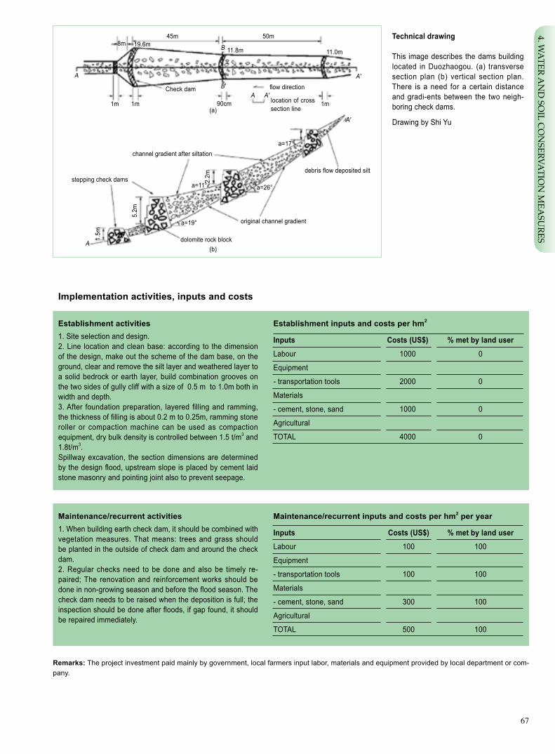
67
Implementationactivities,inputsandcosts
Establishmentinputsandcostsperhm2
Inputs Costs(US$) %metbylanduser
Labour 1000 0
Equipment
- transportation tools 2000 0
Materials
- cement, stone, sand 1000 0
Agricultural
TOTAL 4000 0
Establishment activities1. Site selection and design.2. Line location and clean base: according to the dimension of the design, make out the scheme of the dam base, on the ground, clear and remove the silt layer and weathered layer to a solid bedrock or earth layer, build combination grooves on the two sides of gully cliff with a size of 0.5 m to 1.0m both in width and depth.3. After foundation preparation, layered filling and ramming, the thickness of filling is about 0.2 m to 0.25m, ramming stone roller or compaction machine can be used as compaction equipment, dry bulk density is controlled between 1.5 t/m3 and 1.8t/m3.Spillway excavation, the section dimensions are determined by the design flood, upstream slope is placed by cement laid stone masonry and pointing joint also to prevent seepage.
Remarks: The project investment paid mainly by government, local farmers input labor, materials and equipment provided by local department or com-pany.
Maintenance/recurrentactivities1. When building earth check dam, it should be combined with vegetation measures. That means: trees and grass should be planted in the outside of check dam and around the check dam. 2. Regular checks need to be done and also be timely re-paired; The renovation and reinforcement works should be done in non-growing season and before the flood season. The check dam needs to be raised when the deposition is full; the inspection should be done after floods, if gap found, it should be repaired immediately.
Maintenance/recurrentinputsandcostsperhm2 per year
Inputs Costs(US$) %metbylanduser
Labour 100 100
Equipment
- transportation tools 100 100
Materials
- cement, stone, sand 300 100
Agricultural
TOTAL 500 100
debris flow deposited silt
original channel gradient
dolomite rock block
channel gradient after siltation
stepping check dams
flow direction
location of cross section line
Check dam
90cm1m1m 1m
a=17°
a=26°a=11°
a=19°
5.2m
2.2m
1.5m
8m 19.6m11.8m 11.0m
45m
B'
B
50m
(a)
(b)
A′
A′
A
A
A
A′
Technicaldrawing
This image describes the dams building located in Duozhaogou. (a) transverse section plan (b) vertical section plan. There is a need for a certain distance and gradi-ents between the two neigh-boring check dams.
Drawing by Shi Yu
4. WA
TER AN
D SO
IL CO
NSERVA
TION
MEA
SURES

68
Strengthens and →howtosustain/improve
Erosion control to decrease sediment → Check dams building.
Effective use of rainfall resources → Compound manage-ment combining with plant cultivation and aquaculture.
Increasing farmer’s income → Completing irrigation facil-ity and planting economic forest.
Mitigating debris flow and flood loss →Making planning and design cooperating with watershed management.
Weaknesses and → how to overcome
Large investment, → Multi-level investment system, including central government in-vestment with local support, labor input by farmers, and foreign and social investment.
Disturbance of the earth’s surface, causing ecological destruction → Combining biological measures.
Assessment
Acceptance/adoption- Due to incentive measures taken, including cash payment, agricultural skills training, subsidies of tools, fertilizer, seeds, etc., pri-
ority access to land use rights, and other incentives, the relevant policies are accepted by local residents, who have contributed a certain amount of labors and tools for the project.
- Encouraged by the incentive policies about 80% of rural households accepted this method and even 80% of rural people accepted this method without incentive policies applied.
Benefits/costsaccordingtolanduser Benefitscomparedwithcosts Short-term Long-term
establishment positive positive
maintenance/operation positive very positive
Impacts of the technology
Productionandsocio-economicbenefits Productionandsocio-economicdisadvantages
+ + Warping land, increasing available farmland, promote agricultural None production, increase farmer’s income
+ + Increasing the effecitve use of rainfall resources
Socio-culturalbenefits Socio-culturaldisadvantages
+ + + Develop environmentally-friendly rural areas, promote None harmony between man and nature
+ + + Promoting the development of new countryside
+ + Popularizing soil and water conservation knowledge
Ecologicalbenefits Ecologicaldisadvantages
+ + + Elevating erosion basis, preventing down cutting None + + + Holding and restoring sediment
+ + Prolong flow concentration duration
+ + Preventing landslide and debris flow
+ + Improving local residental environment
Off-sitebenefits Off-sitedisadvantages
+ + Mitigating downstream channel siltation and water pollution – Decreasing the downstream water discharge
Concludingstatements
Key reference(s) [1] Luzheng. Eco-development model of soil and water conservation in China. Beijing: Science publish house. 2003[2] Liu changming, Wang lixian, Xiajun. The study on ecological environment construction and scientific development strategy of
allocation of water resources. Beijing: Science publish house, 2004
Contact person(s) Wang Yongjun. Institute of Soil and Water Conservation, Beijing Forestry University. Email: [email protected]
Land users do not need to bear the cost. The land silted from the earth check dam can be used for cultivation of crops, fast-growing trees, economic forest and medicinal plants. The land users can get a greater economic benefits

69
Check Dam Approach Xifeng County of Gansu Province, China
Check dam is a kind of sediment storage dam built on valey to control the down cut-ting.
Xifeng county is one of the key areas of soil erosion control in China. In order to reduce the local soil erosion, and also to bring certain economic benefits to local residents, the Ministry of Water Resources is in charge of check dam construction activities.
Check dam is widely used in controlling soil erosion. The training is a main approach to promotion of the check dam technology. It is necessary to mobilize local people to participate in construction, while providing to them some cash subsidies. In such a way local people can get economic benefits, and strengthen their awareness and knowledge of soil and water conservation.
Implemetation procedure: (1) site selection and design; (2) material preparation, la-bor rec-ruitment and temporary road buliding; (3) main project construction.
Main objectives: (1) Elevating erosion basis of channel bed to prevent the chan-nel down cutting and channel bank expansion, and decrease channel gradient. (2) Storing silt and reducing the amount of sediment, transported into the rivers. (3) De-creasing channel flow rates and reducing the flood risk of the lower reaches. (4) De-bris flow control by use of strong permanent check dams. (5) Making channel silted to form sediment-covered terraces for future use.
The construction cost of check dam is determined by project quality requirements, difficulty of construction, work size, construction technology, and some other factors. Regional factors have also an important impact. Therefore, the investment is mainly made by government with local supporting funds. Check dam construction is often associated with plant cultivation, aquaculture design and other measures to make comprehensive use of sediment retention and water storage. It can increase agricul-tural productivity and farmers’ income in addition to improve local environment.
left: Overlook of check dams construction in Xifengright: Nearby view of check dams construc-tionin XifengPhoto by Lei Xiaobo
Location: Xifeng Country, Gansu Province, ChinaLanduse: Slopeland/economic forestClimate: Semi-arid WOCATdatabasereference:QARelated technology: Check DamCompiled by: Wang Yongjun, Lei Xiaobo, Shi Yu, Institute of Soil and Water Conservation, Beijing Forestry UniversityDate: September, 2007
Editors’ comments: Check dam works can generate significant benefits by storing and reducing sediment; it also can effectively in-crease the use of rainfall resources, improve the local environment and raise crop yield and farmers’ income.
4. WA
TER AN
D SO
IL CO
NSERVA
TION
MEA
SURES
70
Problem, objectives and constraints
Problem- Serious debris flow, which causes tremendous economic loss and threats to the residents safety. - Serious soil erosion, especially down cutting and expansion of gully.- Poor local economy, lack of funds and technology for soil erosion control.
Objectives- Fixation and raise of erosion basis, preventing down cutting of channel and channel bank expansion. - Making channel silted to form sediment-covered terraces for farming. - Decreasing channel gradient and flow rates and reducing the flood risk of the lower reaches.
Constraints addressed
Major Specification Treatment
Technique factors Check dam design and construction need qualified technicians. Professionals and training.
Economic factors More investment needed for mortar stone check dam. Government and company investment to develop eco-industry.
Minor Specification Treatment
Social factors Unawareness of soil and conservation knowledge. Strengthening education and training.
Differences in participation of men and women: NA.
Participation and decision making
Targetgroups
Desicion makers Designer Experts
Decisions on choice of the technology: SWC experts. Decisions on method of implementing the technology: SWC experts. Approach designed by: National experts.
CommunityinvolvementCheck dam is built in the area where debris flow often occurs, few residents, public activities, no community involvement
Phase Involvement Activities
Initiation NA
Planning NA
Implementation NA
Monitoring/evaluation NA
Research NA
Approach costs met by
Government investment 90%
Enterprises support 10%
TOTAL 100%

71
Extension and promotion
Training:The content includes basic issues of check dam building, knowledge of soil and water conservation, methods for control-ling debris flow and torrent, etc. Better effect for technicians than local residents.
Extension: Related technique standards and information, such as check dam size, technical key point. It should be supported by local government, extended by demonstration. The related organizations including local government and soil & water conservation department play a very important role in the issue. But the extension could be impacted by financial reasons.
Research: The programs of debris flow mechanism, debris flow control measures, bench land use have being carried out.
Importanceoflanduserights:Ownership of land by state is helpful to project implementation.
Incentive mechanism
Labour:Construction Company bids for construction project; construction quality is supervised by supervision experts; and the con-struction company organizes workers to work on. The cost is paid in accordance with the quantity and quality of construction. Do more, pay more and high quality with more pay.
Inputs:The investment includes materials such as stones, sand, cement and others, various types of vehicles and other transport equipment, technical personnel and labor, and design cost. Most of input is purchased and paid by the state and a small part of cost paid by company sponsors.
Credit: NA.
Supportoflocalinstitutions:The application of check dam has positive economic significance because of bringing national funds. Furthermore, it can promote capacity-building of the local Soil and Water agencies and the agricultural institutions through training and projects implementation.
Long-term impact of incentives: Incentive mechanism has a very positive impact on the smooth implementation of projects and long-term maintenance.
Organogram
Ministry of water resources
The Yellow River WaterCon-servancy Committee
Bureau of administration of the upper-middle reaches of the Yellow River
The soil and water conservation division, Department of water resources, Gansu
Bureau of supervision of soil and water conservation of Xifeng
Design Institution ConstructionCompany
SupervisionInstitution
Land Users
4. WA
TER AN
D SO
IL CO
NSERVA
TION
MEA
SURES

72
Monitoringandevaluation
Key reference(s) [1] Liuzheng. Eco-development model of soil and water conservation in China. Beijing: Science publish house, 2003[2] Liu changming, Wang lixian, Xiajun. The study on ecological environment construction and scientific development strategy of
allocation of water resources. Beijing: Science publish house, 2004
Contact person(s) Wang Yongjun. Institute of Soil and Water Conservation, Beijing Forestry University. Email: [email protected]
Methods and indicators
Methods: monitoring sites identification, RS application, related instruments.Indicators: debris flow frequency,speed,volume, time and damage.
Methods: long-term maintenance and repair immediately when required.Indicators: damage degree etc.
Methods: sampling survey and questionnaire.Indicators: accredited attitude for debris flow control and participation in check dam building.
NA
Methods: site survey.Indicators: control area.
NA
Methods: sampling survey and questionnaire.Indicators: science and rationality of Management.
Monitored aspects
Bio-physical
Technical
Socio-cultural
Economic/production
Area treated
No. of land users involved
Management of approach
Strengthens and →howtosustain/improve
Erosion control to decrease sediment → Check dams building.
More effective use of rainfall resources → Develop compound management with cultivation and aquaculture.
Increasing farmer’s income → Completing irrigation facility and establishing economic forest.
Mitigating damage caused by debris flow and floods → Making planning and design on watershed management.
Weaknesses and → how to overcome
Large investment, → Multi-level investment system, which includes nation-al investment with local support, labor input by farmers, and use of foreign and social funds.
After abolition of the compulsory labor and accumulative labor service, the enthusiasm and willingness of farmers to participation is lowered → Some measures shoule be taken by government at all levels to stimulte and en-courage farmers to participate in the construction work.
Impacts of the approach
Changesasresultofmonitoringandevaluation:Economic efficiency of input, structure suitability, long term maintenance.
Improved soil and water management: Hazard area is decreased, destructive force is lowered; debris flow is controlled to a large extent. At the same time the environment is obviously improved, diversified business models are formed and the local econ-omy is improved.
Adoptionoftheapproachbyotherprojects/landusers:The method will help to control debris flow; the check dam is widely used.
Sustainability:Construction cost is quite high, but direct economic benefit is not obvious, therefore, it needs national government investment. It is difficult to carry out check dam construction without long-term support.
Concludingstatements

73
Fish-Scale Pit Adverse-Slope Site Preparation Pingliang City of Gansu Province, China
Site preparation is conducted by altering the micro terrain of slope with gradient over 20o into a fish scale pit at adverse slope with setting shrub and grass to prevent soil and water erosion.
Technical pilot is set in Kongtong district of Pingliang City, the eastern part of Gansu Province. The natural conditions feature meagre and uneven precipitation, crisscross gullies distributed in scattered manner, loose loess soil and severe soil erosion. In long water and soil conservation practice, local departments of forestry and water & soil conservation have summarized experiences and effective biological erosion con-trol measures. The fish-scale pit technique is one of them. It is an engineering and vegetation combined erosion control measure, which is suitable for steep slope and broken hilly lands. Its main function is to intercept surface runoff and increase soil moisture in favour of raised plant survival rate. It features simple construction, flexible and less restriction by landform, satisfactory result in water conservation to allow high survival rate of trees planted.
The fish-scale pit specifications include large pit (0.8-1.5m in length and 0.6-1m in width) and small pit (0.7m in length and 0.5m in width) with their depth ranging from 0.6 to 0.8m. The large pit can be used for medium slope with thick soil and good vegeta-tion while small pit for slopes with thin soil, steep gradient and broken landscape.
Fish-scale pit construction procedure: dig semi-circle shaped pits with the pit spac-ing of 2m and pit layout in delta arrangement. The outer edge is constructed in lune shaped earth bank. Put top soil aside and use base soil to build the bank 20-25cm high. Backfill the top soil in the pit and keep the opening horizontal or slightly inclined inward. The tree should be planted in the middle or lower parts of the pit, instead of up-per part, to prevent the plant from being silted.
Fish-scale pit maintenance: the pits may be flooded in heavy rain or storm in the first and second year after construction. Therefore, repair and maintenance are required to restore them pursuant to above specifications.
Fish-scale pit can change light, heat and moisture conditions in the pit and increase soil water content up by 40% and plant survival rate by 37%. It has minor detriment to original landscape and vegetation. It is a protective vegetation recovery technology.
Fish-scale pit technology is simple, easy-operating, at a low cost, without need for mechanic operation. With little disturbance to environment, it does not result in extra soil erosion and operation is not affected by seasons. In 1950s and 1960s, fish-scale pit site preparation was applied in Kongtong District achieving high survival rate and effective control over soil erosion. This technique can be adopted by integrating with other technologies such as contour terracing, levelled slope platform etc. for greater role in local ecological construction.
Left: Fish scale and adverse-slope site prep-aration at steep slopes. Photo by Wang YaolinRight: Planted seedling in the prepared pit. Photo by Dou Hongqi
Location: Kongtong District, Pingliang City, Gansu ProvinceTechnologyarea: 140km2 SWCmeasure: Engineering and vegetationLanduse: Forest land Climate: Semi-humidWOCATdatabasereference:QTRelated approach: Project Based Fish-Scale Pit Site Preparation for ForestationCompiled by: Wang Yaolin, GEF/OP12 Project Management Office, Gansu Sand Control Re-search Institute; Dou Hongqi, Kongtong Dis-trict Fruit Industry Bureau of Pingliang CityDate: Revised in September 2007
Editors’ comments: This technology is ap-plied generally for afforestation at steep slopes of loess plateau in Gansu Province. The application is simple and effective, so it is a major soil and water conservation measure for loess plateau ecological improvement. It is now mainly used in the public owned land forestation, and technological extension done offered by forestry and water resource depart-ments with incentives.
4. WA
TER AN
D SO
IL CO
NSERVA
TION
MEA
SURES
74
very steep (>60)steep (30–60)hilly (16–30)rolling (8–16)moderate (5–8)gentle (2–5)flat (0–2)
Growing season: 160 days in succession, from May to October Soil fertility: low Soiltexture:moderate loamSurfacestoniness: moderate Topsoilorganicmatter:low(<1%)Soil drainage: moderateSoil erodibility: high
>4000 >4000 3000–4000 3500–4000 2000–3000 3000–3500 1500–2000 2500–3000 1000–1500 2000–2500 750–1000 1500–2000 500–750 1000–1500 250–500 1000–500 <250 <500
Soil depth (cm)
0–20 20–50 50–80 80–120 >120
Classification
LanduseproblemsSteep slope, poor water retention capability of soil, and low forestation survival rate; low vegetation cover and serious soil and water erosion; low utilization rate of slope surface runoff. Landuse Climate Degradation SWCmeasure
Sub-humid
Technicalfunction/impactmain: - change micro topography - retain runoff, improve soil water retaining ability - improve vegetation environment and tree survival rate - detain silt and reduce soil and water erosion
Environment
NaturalEnvironment
Averageannualrainfall(mm) Altitude(ma.s.l.) Landform Slope(%)
Perennial arbor or bush
Water erosion
Mechanical measure
Landuserights:collective Land ownership: state owned Market orientation: selling or self use Leveloftechnicalknowledgerequired:moderate for technical extensionists and land users Importance of off-farm income: 10%-50% of total income
Humanenvironment
Mixedlandperhousehold(hm2)
<1 1–2 2–5 5–15 15–50 50–100 100–500 500–1000 1000–10000 >10000
ridges
ridgeshill slopes
foot slopesvalley floors
mountain slopes
plains/plateaus
secondary: - alleviate silt inflow into Yellow River - increase vegetation cover - improvement of ecological condition

75
Establishmentinputsandcostsperhm2
Inputs Costs(US$) %metbylanduser
Labour 253 0
Equipment: spade 2 100
Materials
Other: training etc 4.7 0
TOTAL 259.7 0.7
Establishment activities1. Pit positions are set along the conture line.2. Dig semicircular pit, pile up topsoil aside the pit, base earth piled beneath pit; Build semicircular protection edge of 30 cm outside the pit, put back topsoil into pit; Open one ditch at both left and right sides of the pit for rainwater collection. 3. Planting at the middle and lower parts of the pit.
Remarks: The cost refers to the labour cost paid by government to farmers or herdsmen for their labour input to the state or collective owned land; Depreciation cost for farmer or herdsman’s tool uses and technical training cost are based on tool actual wastage rate and subsidy to the trainers; labour cost is calculated at 40 Yuan per person day. Exchange rate: US$ 1 = RMB 7.5 Yuan.
Technicaldrawing
Upper:By the fish scale pit prepara-tion, micro typography is changed, and the prepared pits are distributed in delta form on slope surface.
Lower: The inner earth is dug out to make protection edge while the origi-nal surface soil be refilled to the dug pit. The plant is planted at the middle and lower parts of the pit. The speci-fications: 80-150cm long, 50-100cm wide, 30-40cm deep.fish-scale pit
water storage
water introduction
fish-scale planting pit structureUpper: cross section Lower: configura-
tion form
soil
Implementationactivities,inputsandcosts
Maintenance/recurrentactivities1.repair pit in autumn and spring by rebuilding the rainwater damaged earth edge.2.Dredge the water inducing ditches of both sides.
Maintenance/recurrentinputsandcostsperhm2 per year
Inputs Costs(US$) %metbylanduser
Labour 10.7 100
Equipment such as tools
Materials
Other
TOTAL 10.7 100
4. WA
TER AN
D SO
IL CO
NSERVA
TION
MEA
SURES

76
Strengthens and →howtosustain/improve
Intercept runoff → More vigorously technical extension.
Retain silt → Combinations with other measures for en-larged effect.
Raise tree survival rate → Add pit mulching technology to improve sur-vival rate and growth.
Improved soil condition → Suitable legume plants planted.
Weaknesses and → how to overcome
Difficulty in dissimilation → Forest land use right refrom.
Difficult application without project support → Make project sustainable.
Assessment
Acceptance/adoption- All households in the project area used this technology for slope wasteland afforestation. - Forestry and water resources departments are disseminating the technology. - The land use right belong to the collective or state, so the farmers accept the method passively. - With no external financial support, extending the technology is difficult.
Benefits/costsaccordingtolanduser Benefitscomparedwithcosts Short-term Long-term
Impacts of the technology
Productionandsocio-economicbenefits Productionandsocio-economicdisadvantages
+ + + Improved tree survival None
+ Income increased
Socio-culturalbenefits Socio-culturaldisadvantages
+ + Improved living environment and quality High labour intensity
Ecologicalbenefits Ecologicaldisadvantages
+ + + Reduce soil and water erosion None
+ + + Increase soil moisture
+ + + Improve survival rate of forestation
+ + Increase vegetation cover
+ + Reduce silt to the downstream
Off-sitebenefits Off-sitedisadvantages
+ + Reduce soil and water erosion and reduce downstream Reduce runoff of downstream river course river silt
Concludingstatements
Key reference(s) Wang Hui, Liu Qianzhi, Wang Jie. Integrated Treatment Technology of Combating Desertification. Beijing: China Forestry Publish-ing House, 1998
Contact person(s) Wang Yaolin, GEF/OP12 Project Management Office, Gansu Sand Control Research Institute. Tel: 0931-8412816. Email: [email protected]
establishment
maintenance/recurrent
high input, low benefit
high input, low benefit
low input, high benefit
low input, high benefit
_
_
_

77
Project Based Fish-Scale Pit Site Preparation for Forestation Pingliang City of Gansu Province, China
Project-based and led by government fish-scale pit site preparation is undertaken, through publicity among local residents, and achieve success. It has improved site conditions, developed runoff forestry and improved ecological environment.
The water and soil conservation work is carried out mainly through project im-ple-mentation and technology dissemination is the responsibility of water and soil con-servation depart-ment, forestry administration, etc. In recent years, the central gov-ernment has launched projects of “Conversion of Farmland to Forest”, “Desertification Control”, “Integrated Small Watershed Management”, and the World Bank funded Loess Plateau Projects (Phase I and II) as well as “DFID Watershed Management” projects, which have brought to Gansu loess plateau a new opportunity of letting wa-ter and soil conservation work to step up to a new stage.
Technology dissemination has been carried out via villager meeting, field demonstra-tion and household visit to introduce the technology. Before site preparation is con-ducted, villager meeting is held and the technicians from forestry administration or soil conservation department will give lectures to the residents to let them be aware of the significance of water and soil conservation.
Fish-scale pit expense will be covered by the project and local government. The farmers will be paid in cash for their labour input. And in some areas, local farmers are willing to make labour input in the project. The seedling cost is paid by project and local government.
The government owns the right to use the arid lands suitable for forestation and there is no direct economic benefit from barren hill forestation, dam construction and other water and soil conservation projects. Farmers are passive to accept water and soil conservation tasks. Therefore, it is difficult to scale up the project without com-pensation for the labour input of farmers. At present, the pilot project site has begun forest ownership reform, and auction the use right of the barren hills and lands for 50 years duration. Such action has greatly stimulated the enthusiasm of local residents for participation in water and soil conservation and ecological improvement.
Left: Fish scale site preparation. Photo by Dou HongqiRight: Villagers meeting to discuss technol-ogy of fish scale site preparation. Photo by Dou Hongqi
Location: Kongtong District of Pingliang city, Gansu ProvinceLanduse: Forest land Climate: Sub-humid arid WOCATdatabasereference:QARelated technology: Fish-Scale Pit Adverse-Slope Site PreparationCompiled by: Wang Yaolin, GEF/OP12 Project Management Office, Gansu Sand Control Re-search Institute; Dou Hongqi, Kongtong District Fruit Industry Bureau of Pingliang City Date: Revised in September 2007
Editors’ comments: The technology is ap-plied now relying on the technical promotion efforts done by departments of forestry, water resources and agriculture, with incentive of projects. It is easy operation and low cost, with very notable effect in retaining rainwater and improving soil moisture. It has been regarded as important SWC and runoff forestry mea-sure, and applied widely in SWC projects and cash forest development in China.
4. WA
TER AN
D SO
IL CO
NSERVA
TION
MEA
SURES

78
Problem, objectives and constraints
Problem- Community feels shortage of available funds. - Lack of effective organization. - No direct economic benefit, so the farmers participation enthusiasm is low.- Serious soil and water erosion. - Poor site conditions and low survival rate of planting.
Objectives- Establish technical extension mechanism of sustainable development. - Raise community’s participation level. - Creation of a swc model for stakeholders’ equal participation.- Improve ecological condition.
Constraints addressed
Major Specification Treatment
Land tenure The state owns land use right, so the farmers are passive in Reform the forest land tenure,including auctioning and leas participation. ing etc.
Social aspect Extension done solely through government, without farmer’s Establish incentive mechanism, strengthen demonstration, active participation. and combine with the tenure reform.
Financial Shortage of financing, a little project support, and low Gain more project support and add subsidies to farmers. subsidies to farmer labour input.
Participation and decision making
Targetgroups
Land user SWC expert Planning expert Decision maker Decisions on choice of the technology: Water Resources Bureau and Forestry Bureau of the county. Decisions on method of implementing the technology: Water Resources Bureau and Forestry Bureau of the county. Approach designed by: National experts of forestry and water resources.
Communityinvolvement
Phase Involvement Activities
Initiation Interaction Meetings or publicity by interview in householders.
Planning Passive Provide information of the actual situation of the site.
Implementation Passive Local farmers and herdsman are employed to implement the technology and project by contributing labour.
Monitoring/evaluation Passive Technicians visit the households for interview.
Research None None.
Approach costs met by
Government 99.3%
Farmers(depreciation of tools) 0.7%
TOTAL 100%
Differences in participation of men and women: The technology needs labor to work on remote slopes, so mainly done by male labour.

79
Extension and promotion
Training:Technical staff by training meeting, site explanations of fish scale structure, role and construction requirement, and at the same time species selection and planting method. The training effect is good.
Extension: Technical extension conducted by county water resources and forestry technological extension organizations, in forms of meetings and field demonstrations.
Research: Research is conducted at provincial level, and mainly on how to raise moisture utilization rate, increase wood increment; Farmers do not participate in research.
Importanceoflanduserights:The land ownership and use right of barren mountain belong to the state or collective , whcih af-fected negatively the technological application.
Incentive mechanism
Labour:Labor force is paid at the prevailing price level.
Inputs:Seedlings are supplied with project financing, and tools supplied by farmers.
Credit: Some projects use credit.
Supportoflocalinstitutions:The training of this technology improved the capacity of local bureau staff of water resources, forestry and agriculture. The technology also helped gain support of international donor supported projects.
Long-term impact of incentives: The long-term influence of project support is positive; With project support, the possibility for farm-ers to invests using this technology is low. The long term negative impact is neutral.
Organogram
Left: Fish scale pit planting site preparation technology is supported by State Frestry Ad-ministration through projects.
Right: Fish scale pit planting site preparation technology is also supported by Ministry of Water Resources through projects.
State Forestry Administration
County (District) Forestry Bureau
Provincial Forestry Department
Township Forestry Station
Land Users
City Foresty Bureau
Ministry of Water Resources
County WR Bureau
Provincial Water Resources Department
Township WR Station
Land Users
City Water Resources Bureau
4. WA
TER AN
D SO
IL CO
NSERVA
TION
MEA
SURES

80
Monitoringandevaluation
Key reference(s) Wang Hui, Liu Qianzhi, Wang Jie. Integrated Treatment Technology of Combating Desertification. Beijing: China Forestry Publish-ing House, 1998
Contact person(s) Wang Yaolin, GEF/OP12 Project Management Office, Gansu Sand Control Research Institute. Tel :0931-8412816. Email: [email protected]
Methods and indicators
Change of soil moisture, runoff quantity, sediment delivery modulus.
Survival rate of planted seedlings, vegetation cover change.
Survey the awareness of villagers on the technology including the its function and benefit.
Growth increment of the seedlings.
Survey the acreage that adopt the technology every yeare.
Survey the number of households involved in participation and that of directly benefited households.
Use methods of observation and site survey to regularly investigate the acreage that adopt the technology and the benefit.
Monitored aspects
Bio-physical
Technical
Socio-cultural
Economic/production
Area treated
No. of land users involved
Management of approach
Strengthens and →howtosustain/improve
Incentive measures promote the technical enforcement → Implement project to maintain the financing.
High efficiency of the extension mechanism → Further raise capability of technical staff in provision of technical service.
Weaknesses and → how to overcome
Single technical extension model → Establishment of more effective and motivating incentive mechanism and models, and promote farmers par-ticipation in the extension considering combination with forest land tenure reform.
Forest land is owned by collective, therefore it is a disadvantageous factor to strengthen achievements of project → Reform the forest land tenure.
Impacts of the approach
Changesasresultofmonitoringandevaluation:The technical extension method has evolved from direct popularization pushed by government to the current government-led, incentive motivated technical extension. Now the technology is being ap-plied in cash forest cultivation on slopeland.
Improved soil and water management: It alleviated soil erosion significantly, improved the moisture condition of soil, and raised the utilization rate of slope surface runoff.
Adoptionoftheapproachbyotherprojects/landusers:The technology is now also used for slope maintenance of highway and railway.
Sustainability:Without financial support, application of this technology will be hard.
Concludingstatements

81
ZhuanglangLoessTerracesZhuanglang County of Gansu Province, China
Level bench terraces on the Loess Plateau is used to convert eroded and degraded sloping land into a series of terraces suitable for cultivation.
The Loess Plateau in north-central China is characterised by very deep loess parent material (up to 200 m ),that is highly erodible and the source of most of the sediment in the lower reaches of the Yellow River.
The plateau is highly dissected by deep gullied valleys and gorges. The steep slopes, occupying 30%-40% of the plateau area, have been heavily degraded by se-vere top soil and gully erosion. Over the whole Loess Plateau approximately 73,350 km2 of these erosion prone slopes have been conserved by terraces.
In the case study area (Zhuanglang County) the land that is suitable for terracing has been completely covered. The total terraces area 1088 km2 accounting for 90% of the slopes and proceeding form valley to the ridge. The terraces comprise a riser of earth, with vertical or steeply sloping sides and an approximately flat bed (level bench). Depending on farmers preference some terrace beds are edged by a raised lip (a small earth ridge) which retains rainwater, others remain without lip. The semi-arid climate does not require a drainage system. For typical hillside terraces on slopes of 25%-35% the bed with is about 3.5-5 meters with a 1-2 meter riser, involv-ing moving about 2000-2500 cubic meters of soil (see table of technical specifica-tions). Generally the rivers are not specifically protected, but there may be some natural grasses growing on the upper part. The lower part of the river is cut vertically into the original soil surface, and has no grass cover, being dry and compact. How-ever it is not erosion-prone since it has a stable structure.
Over most of the Loess Plateau, the soil is very deep and therefore well suited to terrace construction. In addition to downstream benefits, the purpose is to create a better environment for crop production through improved moisture conservation, and improved farming operations. In an average rainfall year, crop yields on terraces land are more than 3 times higher than they used to be on unterraced sloping land. The implication is that terrace construction – though labour intensive pays back in only three to four years when combined with agronomic improvements (such as applying farm yard manure and planting green manure ). Some farmers try to make the best use of the upper part of terraces risers by planting cash trees or forage cropsinclud-ing Hippophae rhamnoides (seabuckthorn), Caragana korshinskii (peashrub) and some leguminous grass. This is locally termed “terrace bund economy”. The plants stabilise the risers and at the same time provides extra benefit.
Left: Aerial view over zhuanglang county Where 90% of the hillsides are covered with ter-races. Reducing runoff and erosion,maintaining soil fertility and making farming operations eas-ier are key for rainfed agriculture in this semi-arid environment. Photo by He YuRight: A 4m high terraces riser, where the part is vertical and baredemonstrating the sta-bility of the loess soil at this depth. The upper part is sloping, and stabilised with grasses, bushes and trees. Photo by Hanspeter Liniger
Location: Zhuanglang County, Gansu Province (loess plateau region ), chinaTechnologyarea: 1080km2 SWCmeasure: StructuralClimate: Semi-aridWOCATdatabasereference:QT CHN45Related approach: Terrace ApproachCompiled by:Wang Yaolin, GEF/OP12 Project Management Office, Gansu Sand Control Research Institute; Wen Meili, De-partment of Resources and Environment Sci-ence, Beijing Normal University, China; Bai Zhanguo, World Soil Information, Wagenin-gen, Netherlands.Date: March, 2006
Editors’ comments: China has history of ter-races construction dating back thousands of years-for both rainfed crops and paddy rice.In the period since the 1950s’ the loess Plateau region has been extensively terraced to reduce off – site sediment levels in the Yellow River, and to create better conditions for crop produc-tion.The results are effective and spectacular covering an area of over 73,000 km2.
4. WA
TER AN
D SO
IL CO
NSERVA
TION
MEA
SURES

82
very steep (>60)steep (30–60)hilly (16–30)rolling (8–16)moderate (5–8)gentle (2–5)flat (0–2)
Growing season: 160 days (May to September) Soil fertility: medium to low Soiltexture:medium (loam)Surfacestoniness: no loose stone Topsoilorganicmatter:low <1%)Soil drainage: goodSoil erodibility: very high
>4000 >4000 3000–4000 3500–4000 2000–3000 3000–3500 1500–2000 2500–3000 1000–1500 2000–2500 750–1000 1500–2000 500–750 1000–1500 250–500 1000–500 <250 <500
Soil depth (cm)
0–20 20–50 50–80 80–120 >120
Classification
LanduseproblemsCultivation of unterraced hillside slopes leads to serious soil erosion and problems of downstream sedimentation. Loss of topical and rainwater in uncontrolled runoff has contributed declining crop yields.
Landuse Climate Degradation SWCmeasure
Semi-arid
Technicalfunction/impactmain: - reduction of slope angle/slope length - retain runoff in -situ - increase infiltration - water harvesting/increase water stored in soil - reduces downstream flooding and sediment deposition (a nation /regional concern)
Environment
NaturalEnvironment
Averageannualrainfall(mm) Altitude(ma.s.l.) Landform Slope(%)
Farmland Cash froest
ChemicalFertility decline
Water erosion
Mechanical measure
Landuserights:cropland :individual ,subject to reallocation by authorities ;forest land: commu-nal (organised) Land ownership: state Market orientation: mixed (subsistence/commercial):cash crop (peas)and food crops(potatoes, wheat, maize, millet, sorghum) Leveloftechnicalknowledgerequired:field staff/extension worker: high, land user: low Importance of off-farm income: 10%/10%-50%/ of all income: working in construction ,tempo-rary employments
Humanenvironment
Mixedlandperhousehold(hm2)
<1 1–2 2–5 5–15 15–50 50–100 100–500 500–1000 1000–10000 >10000
ridges
ridgeshill slopes
foot slopesvalley floors
mountain slopes
plains/plateaus

83
Establishmentinputsandcostsperhm2
Inputs Costs(US$) %metbylanduser
Labour
Construction: 600m person days 1200 97
- survey 60 0
Equipment
- shovel, 2-wheel cars 30 100
materials
- earth(2000-2500) 0 0
TOTAL 1290 93
Establishment activities1. Contour lines are marked out using pegs to show the location for the base of each terrace wall (after harvest in September)2. A trench is dug out along the marked line to serve as the founda-tion for the terrace wall.3. The topsoil between the pegged lines is removed and put aside.4. Alternative ways of construction the wall/riser and bed: (a) Sub-soil is placed in the trench and compacted to form the base of the terrace is then place behind the wall. The wall is progressively built up (by compacting earth) with the excavat-ed soil placed behind until a level terrace has been formed.(b)terraces may be built without constructing an initial wall: soil excavated form the upper part of the (eventual) to help build up the wall/riser. This is done progressively.5. The wall is raised slightly higher to form a lip to retain rain-water on the terrace bed(optional).6. The set-aside topsoil is then spread over the terrace surface.
Duration of establishment: 3-4months.
Maintenance/recurrentactivities1. Repairing any collapses in the terrace wall-often caused heavy storms.2. Re-levelling of the terraces where necessary.
This work is usually done by hand, using shovels and 2-wheel cars.
Maintenance/recurrentinputsandcostsperhm2 per year
Inputs Costs(US$) %metbylanduser
Labour 25 97
equipment
- tools (shovel.2-wheel cars) 10 100
materials
- earth(1-2m3) 0 0
TOTAL 35 98
Remarks: calculations above are base on the following situation: slopes of about 25%-35%, bed width of 3.5-6m, and a 1-2m high rise, involving mov-ing about 2000-2500 cubic meters of soil. Note: these calcuation are base on several years experience in zhuanglang: that is why they differ in some respects from the standardised table above.
Technicaldrawing
Layout of level bench terraces on the loess plateau; the lower vertical section is cut into the compacted soil. Natural grassesor planted grass/shrub species protect the more erodible and less steep upper part of the riser.
The low “lip” is optional.
Insert1: method of construction: the vol-ume of soil to be excavated from the hill-slope (see table below) equals the volume “returned” to form the outer part of the terrace.
Insert2:Chinese Bench Terrace Techni-cal Specifications.
Implementationactivities,inputsandcosts
25%-35%
0.2-0.3m3.5-5m
1-2m
1
original slope
2 Chinese Bench Terrace Technical Specifications slope Height of Bench Volume of soil to Man days/ha in° ridge(VI)in m width in m be dug(m3/ha) (m3/man day)
0-9° 1.0 11.20 1,230 405 2.0 22.30 2,670 885 1.0 5.31 1,200 405 9°-18° 1.5 7.80 1,830 600 2.0 10.20 2,700 900 1.0 3.37 1,305 435 18°-27° 1.5 4.90 1,950 645 2.0 6.30 2,670 885 1.0 3.42 1,815 600 27°-36° 2.0 4.34 2,445 810 2.5 5.12 3,090 1,035 2.0 3.80 2,475 825 36°-47° 2.5 4.60 3,105 1,035 3.5 6.30 4,320 1,440
4. WA
TER AN
D SO
IL CO
NSERVA
TION
MEA
SURES

84
Strengthens and →howtosustain/improve
Reduced erosion, loss of rainwater through runoff and fertility loss → Maintain the quality of terrace construction.
Increased soil moisture → Construct/maintain a terrace lip to retain rainwater on the terrace.
Increased crop production → Combine with improved crop husbandry.
Easier field oiperations → The level terrace is easy to cultivate.
Weaknesses and → how to overcome
Decrease in production in first year → Apply manure and fertilizer.
Terrace riser can be destroyed by storms → Good andtimely repair and maintaince.
High crost/input for construction and establishment → There is no real al-ternatives to labour –Intensive terracing.
High loss of soil moisure due to evaporation form the soil suiface. wind ero-sion due to tillage → Protect soil surface for example by conservation agri-culture –comprising permanent cover ,crop rotation ,reduced tillage- could be supplementary agronomic and vegetative options.
Assessment
Acceptance/adoption- The technology was implemented on a large scale through government initiated mass campaigns.- Through government intervention the area that is suitable for terracing has been covered.- Uncertainty over future land use rights limits the willingness of households to meet the costs of terrace construction.
Benefits/costsaccordingtolanduser Benefitscomparedwithcosts Short-term Long-term
establishment negative very positive
maintenance/recurrent positive very positive
Impacts of the technology
Productionandsocio-economicbenefits Productionandsocio-economicdisadvantages
+ + + Crop yield increase (wheat :from 750-900 kg/hm2 before terracing Reduced production (first year only) to 3000-3750 kg/hm2 within 3-4 years:includes agronomic improvements)
+ + + Easier field operation
+ Farm income increase
Socio-culturalbenefits Socio-culturaldisadvantages
+ + Community institution strengthening None
+ + Improved knowledge SWC/erosion
Ecologicalbenefits Ecologicaldisadvantages
+ + + Soil loss reduction None
+ + + Increase in soil moisture
Off-sitebenefits Off-sitedisadvantages
+ + + Reduce doenstream siltation Reduced river flows
+ + Reduce doenstream flooding + + Educe transported sediments
Concludingstatements
Contact person(s)Wang Yaolin, GEF/OP12 Project Management Office, Gansu Sand Control Research Institute. Tel :0931-8412816. Email: [email protected]
_
__

85
Terrace Approach Zhuanglang County of Gansu Province, China
Highly organised campaign to assist land users in creating terraces: support and planning from national down to local level.
Before 1964, the slopes on China’s Loess Plateau was cultivated by machinery. Con-sequently soil and water lost at high rates, and fertility and yields declined. Acces-sibility to cultivated land became more and more difficult due to dissection by gullies. The first terraces were established by self-mobilisation of the local land users. How-ever there was no standard design. Furthermore, as the individual plots were very small and scattered all over the village land, terracing needed better coordination, Between 1964 and 1978, the local government at the county level took the initia-tive of organising farmers and planning terrace implementation according to specific technical design on a larger scale. At that time the land was still managed by produc-tion brigades. People were organised to collectively terrace the land on the village basis covering around 2000 hectares each year. Labour was unpaid.
The Yellow River Conservancy Commission (YRCC) came into being in 1948-and the Upper and Middle Yellow River Bureau in 1977. This gave greater impetus to the implementation of SWC in the Loess Plateau. After 1978, the use rights were allo-cated to individuals (though official ownership was still vested in the state). SEC spe-cialists and county level SWC bureau started to work with groups of farmers who had land use rights within a given area. Survey and design were carried out. The farmers organised themselves, consolidated the parcels of land, and then after the conserva-tion work was done they redistributed the terraced fields.
In 1980s the government started to financially support land users involved in SWC projects. Subsidies ranged from (approx)US$ 20/hm2 in projects at county level, to US$ 55/hm2 when World Bank projects were involved. tools were provided by farmer themselves. Then, in 1988 a nationwide project in SWC-which originally was proposed at county level-was approved by the national government. Furthermore, in 1991 a national law on SWC came into force. Protection of the Yellow River and associated dams became a priority at regional and national levels. In total, within Zhuanglang County, 60 SWC specialists/extensionists cover an area of 1550km2,and most of the terraces were built with low levels of subsidies. Annual plans about implementation of new SWC measure were made during summer. Small areas were designed at county level. Implementation then took place winter. Terracing was implemented first there, where access was easiest and nearest or where villages lo-cated.
Left: Mass mobilisation showing people from several villages helping each others. Initially farmers were not paid but from the 1980s on-ards farmers recieved cash and other support for their work. Photo from terraces in China, Ministry of AgricultureRight: Construction of terrace risers following instructions given by a specialist. Photo from terraces in China, Ministry of Agriculture
Location: Zhuanglang County, Gansu Prov-ince loess plateau region, Norhern China, people’s Repubic of China Landuse: Cropland Climate: Semi-aridWOCATdatabasereference:QA CHN45Related technology: Zhuanglang loess terracesCompiled by: Wang Yaolin, GEF/OP12 Proj-ect Management Office, Gansu Sand Control Research Institute; Wen Meili, Department of Resources and Environment Science, Beijing Normal University, China; Bai Zhangguo, World Soil Information Wageningen, NetherlandsDate: May 2002, updated October 2005
Editors’ comments: The terraces covering china’s loess Plateau are one of the most out-standing SWC achievements in the world. The evolution of this remarkable feat is worthy of note. It is an example of local initiative devel-oping into an organized, structured campaign. The implementation process, through local government initially, and then taken up at na-tional level, was supported by legislation and mass mobilisation.
4. WA
TER AN
D SO
IL CO
NSERVA
TION
MEA
SURES

86
Problem, objectives and constraints
Problem- Lack of organisation, capital and technical knowledge in farmer communities to counter the underlying problems of water loss, soil
loss, fertility decline and downstream effects on the yellow river (floods and sediment ) at catchment level. - Absence or poor maintenance of erosion control measures.
Objectives- Water conservation (this is a semi-arid area). - Soil conservation: reduce soil loss on the slopping and erosion-prone land of loess plateau. - Enhancing soil fertility, and consequently production. - Improve people’s living conditions. - Protect the Yellow river, avoid floods and reducing the sediment load.
Constraints addressed
Legal Land users leased the land form the state and land users’ National government persuade land users to implement right were insecure in the long term. Investments in SWC terraces by selling the benefits(increased yield and were not encouraged. easier workability of the land) after 1978,individual user rights motivated farmers to invest in SWC.
Technical Poor knowledge of how to reduce water loss, soil loss Enhanced guidance by SWC specialists. and fertility loss. Technical solutions were needed at the catchment level, involving the whole population.
financial Intially frmers were not paid and as they hd no iediate After 1988, labour inputs by farmers started to be partly benefit from ,or security over ,the use of the land ,the covered by subsidies provided by local and national investment in construction was a heavy burden on poor government. farmers.
Participation and decision making
Targetgroups
Land users Planners Politicians/deci- sion makers
Decisions on choice of the technology: QA2.1.5.1mainly made by SWC specialists with consultation of land users Decisions on method of implementing the technology: Approach designed by:
Communityinvolvement
Phase Involvement Activities
Initiation Self-mobilisation/interactive Land users started implementing terraces but SWC specialists at the country level assisted in designing standards for terrace construction and township governments and production brigades organised whole villages and watersheds
Planning passive Being consulted in the planning phase. Experienced peasants may be involved in introducing the local situation
Implementation Interactive Major organisation done through the SWC Bureau specialists with the village organisation including land users ware actively involver in implementation
Monitoring/evaluation none Reporting .no participation of land users.
Research none On-station research. No participation of land users.
Approach costs met by
Government 10%
Community/local 90%
Total 100%
Differences in participation of men and women: For manual labour, men can do more work and they have greater technical knowledge and skill related to terrace construction than women.

87
Ministry of Water Resources Province Government
The Upper and Middle Yellow River Bureau Municipal Government
Municipal SWC Station
Villages
Municipal SWC Bureau
Land Users
Yellow River Conservancy Commision (YRCC) Province SWC Bureau
Township Government
Province SWC Bureau
Production Brigades
Production Brigades
Villages
Township Government
Land Users
County Gov-ernment
County Gov-ernment
Count SWC Bu-reau
Count SWC Bu-reau
Extension and promotion
Training:Until 1978 the pyramid system was used; the country leve trained the township level,which trained the villlage level,which in turn rained the production brigades/farmers,who then trained other production brigades and farmers.Training was on-the-job, focussing on design aid construction of terraces on shoping land (provided by the county level specoalists and by land users from villages where implementation areas,and farm visits-these were effective for all target groups.
Extension: The pyraid system is also used for extension At each goverment level(at the county distinct and provincial levels)there is a SWC division which is in charge of SWC activities including extension (demonstration , farm visits, etc).Effectiveness with respect to land users has been good. With rural economic development, more and more land users plan to invest SWC activities, including terrace making. The extension system is quite adequate to ensure continuation of activities.
Research: Mostly on-station research; carried out at the provincial and national levels, mostly by technical staff. Land users have not been involved .Topics covered include economics/marketing, ecology, technology, Terrace building is based on scientific design, ac-cording to local conditions.
Importanceof landuserights:The ownership of the land and its resources belongs to state and communities: land users can only lease the land for a period of time. Due to uncertainty over future user rights and possible reallocation of the land every few years(5,10 or 20)by the village in response to changes in population and household needs, additional investments into land /SWC measures may be hindered .1978 a first major change took place by allocating some individual land use rights.
Incentive mechanism
Labour: In the 1960s and 1970s farmers were not paid for their labour onputs. Form the 1980s onwards the goverment started to reward the community for establishment of terraces with cash;projects paid on the basis of area treated,and at different rates.
Inputs:Shovels and carts were provided by land users.
Credit: credit was available at interest rates (0.5%-1%per year) lower than the market rates.
Supportoflocalinstitutions:Finacial support to local institution was made available through SWC Bureaus.
Long-term impact of incentives: As mero and more payment is currently being made to land users on the basis of the area treated. land users rely more and more on being paid for investments into SWC .The willingness to invest in SWCmearured without receiving financial support has decreased. Thus the use of incentives in the current approach is considered to have a negative long-term impact.
Organogram
Terrace construction supported by proj-ects from MWR,YRCC and international organisations (left)and terrace construc-tion supported by provincial funds (right).
4. WA
TER AN
D SO
IL CO
NSERVA
TION
MEA
SURES

88
Key reference(s) [1] Water and Soil Conservation. Department of Yellow River Water Resources Committee of Ministry of Water Resources and
Electric Power, 1987[2] Jiangdingsheng. ACTA CONSERVATION SOLI ET AQUAE SINICA. Discussion on section design of the terrace on the Loess
Plateau,1987, 2: 28-35
Contact person(s)Wang Yaolin, GEF/OP12 Project Management Office, Gansu Sand Control Research Institute. Tel: 0931-8412816. Email: [email protected]
Methods and indicators
Regular measurements of runoff loss, sediment load soil moisture.
Regular measurements of structure of terraced areas slope of risers, levelness of terrace surface.
Ad hoc observations of land users’ perceptions of terraces.
Regular measurements of yield, income of land users.
Regular measurements of terraced area.
Ad hoc measurements of the numbers of farmers directly involved in terracing and farmers benefited directly.
Ad hoc observations of number of small watersheds terraced.
Monitored aspects
Bio-physical
Technical
Socio-cultural
Economic/production
Area treated
No. of land users involved
Management of approach
Strengthens and →howtosustain/improve
Efficient organization, planning to cover a large area, which is very susceptible to land degradation.
Heavy investment made by the land local as well as national government to reduce land degradation.
Many people involved and trained at different levels (pyramid sys-tem: see training/extension); commitment by all stakeholders.
The collective activities/organisation strengthens the com-munity and enhances social stability and coherence within vil-lages; collective activities are expanded to other sectors, such as road construction ,supply of agrochemical inputs, etc.
Weaknesses and → how to overcome
High costs;farmers depend on external support from goverment ,they are not willing to invest theor labour without payments(as it used to be in com-munisr times) → New approach; give farmers loans for construction as now they use machines to do the work. In addition, search for cheaper SWC technologies and for improving the benefits.
The steeper slopes which are also further away from the village are now often not cultivated and main-tained as they are too fat and marginal in production → Solutions need to be these areas, eg afforestation.
Impacts of the approach
Changesasresultofmonitoringandevaluation:The approach changed fundamentally from self-mobilisation to organised mass movements guided by the government.
Improved soil and water management: Soil and water management have improved a lot: easier workability, intensified land use, in-situ water retention, top soil and fertilizer/manure are not washed away, etc.
Adoptionof theapproachbyotherprojects/landusers:As the Zhuanglang area was one of the pioneering areas for the Loess Plateau other regions were able to profit from the approach has been applied over the whole Loess Plateau-though the level of subsidies for construction is much higher under Word Bank projects.
Sustainability:Given the recent escalation in payments made to land users for implementation under certain projects it seems that the costs will be too high to sustain. Currently the Ministry of Finance is demanding that in-depth cost-benefit analyses are carried out involving environmental, social as well as economic assessment.
Concludingstatements
Monitoringandevaluation
*No recommendations provided on how to sustain/improve the Strengthens in this case study.

89
Plantation of Pinussylvestrisvar. mongolica at Sandyland Hulunbuir of Inner Mongolia, China
Naturally regenerated seedlings of Pinus sylvestris are used for forestation in sandlot to anchor shift sand and safeguard grazing pastures
The project site is situated in Hulunbuir Desert, namely Evenki Autonomous Ban-ner of Hulunbuir City of Inner Mongolia. This desert is located in the western part of Daxing’anling Mountain and distributed in strip shape along Yimin River and Hailar River. There are fixed and semi-fixed dunes, zonality soil is casta-nozems with high sand content, and non-zonality soil is aeolian soil. Typical grassland vegetation and forest vegetation are distributed in eastern part.
To control desertification and improve local environment, the forestry administration and local residents have conducted ecological improvement activities based on the “Three-North” Shelterbelt Programme. The aim is to protect pasture and improve local ecological condition by establishing forest shelterbelt, using pinus sylvestris en-closure and rehabilitation measures to anchor drift sand.
Steps of technical measures implementation as follows: (1) Prior to forestation sea-son in spring, select 30-100cm high naturally regenerated seedlings of Pinus sylves-tris from natural well grown forest or nursery grown seedlings. Mother soil lump is retained when the wild seedlings are dug to keep more than 80% of the roots intact inside the lump. (2) Site is prepared in holes with specifications suiting the wild seed-ling size, i.e. the diameter of hole should be 20cm wider than that of soil lump. The seedling collar should be positioned 15cm below the ground to form a dent for hold-ing water. Thor-ough irrigation should be made in case of large seedling and dry soil. (3) Establish forest patch with mixed tree and grass or belt based on site conditions. In general, at dune areas where is a rolling landform, forest patch should be estab-lished in 4mx4m or 6mx6m spacing. (4) Supplementary planting should be conducted in the following year to maintain at least 85% survival rate. Special guards shall be assigned to patrol and guard the sites, and fence should be erected at places with fre-quent human and livestock activities.
The project has been implemented for more than two decades and the preliminary observation shows that desert has basically been stabilized; grass yield increased by 10% and Pinus sylvestris standing volume increment is of 3m3/hm2, indicating re-markable benefits.
Left: Shelterbelt of Pinus sylvestris var. mon-golica. Photo by Jin WeiminRight: Natural regeneration of Pinus sylves-tris var. mongolica. Photo by Jin Weimin
Location: Erwenki Banner of Hulunbeir City of Inner Mongolia Technologyarea:100 km2
SWCmeasure: Vegetation, engineering, managementLanduse:Grazing, forest landClimate: Sub-humid WOCATdatabasereference:QTRelated approach: Recovering Ecosystem of Hulunbuir Sandysland Based on Three North Shelterbelt ProgrammeCompiled by: Jin Weimin, Hulunbeir City Forestry Bureau; Tian Lü, Inner Mongolia For-estry Survey and Design InstituteDate: August, 2007
Editors’ comments: This technology adopts naturally regenerated seedlings of Pinus sylvestris var. mongolica for desertification control afforestation. With strong adaptability of seedlings to site, the survival rate is high. At the same time, the pattern of planting arrange-ments is forest - grass patch. It accords with natural vegetation requirement. The technol-ogy is suitable to the local conditions and can be a good reference for other similar areas.
5. AFFO
RESTATIO
N IN
ARID
AN
D SEM
I-ARID
AREA
S

90
Growing season:100 days in succession, from May to August Soil fertility: low Soiltexture:coarse sandy Surfacestoniness: moderate Topsoilorganicmatter:low (<1%)Soil drainage: goodSoil erodibility: high
Classification
LanduseproblemsSerious wind erosion and land degradation; vegetation degradation and biodiversity reduction; barren soil and poor land productivity.
Landuse Climate Degradation SWCmeasure
Forest Grazing Sub-humid Wind erosion land
Technicalfunction/impactmain: - fix drift sand and control wind erosion - reduce wind speed - add vegetation cover - improve micro environment
Environment
NaturalEnvironment
Averageannualrainfall(mm) Altitude(ma.s.l.) Landform Slope(%)
Biological measure
very steep (>60)steep (30–60)hilly (16–30)rolling (8–16)moderate (5–8)gentle (2–5)flat (0–2)
>4000 >4000 3000–4000 3500–4000 2000–3000 3000–3500 1500–2000 2500–3000 1000–1500 2000–2500 750–1000 1500–2000 500–750 1000–1500 250–500 1000–500 <250 <500
Soil depth (cm)
0–20 20–50 50–80 80–120 >120
Landuserights:state, collective or individualLand ownership: state or collective Market orientation: mixedLeveloftechnicalknowledgerequired:moderate for technical extensionists and low to land usersImportance of off-farm income: 10%-50% of total income
Humanenvironment
Mixedlandperhousehold(hm2)
<1 1–2 2–5 5–15 15–50 50–100 100–500 500–1000 1000–10000 >10000
secondary: - enrich biodiversity - improve awareness of local people on ecology
ridges
ridgeshill slopes
foot slopesvalley floors
mountain slopes
plains/plateaus
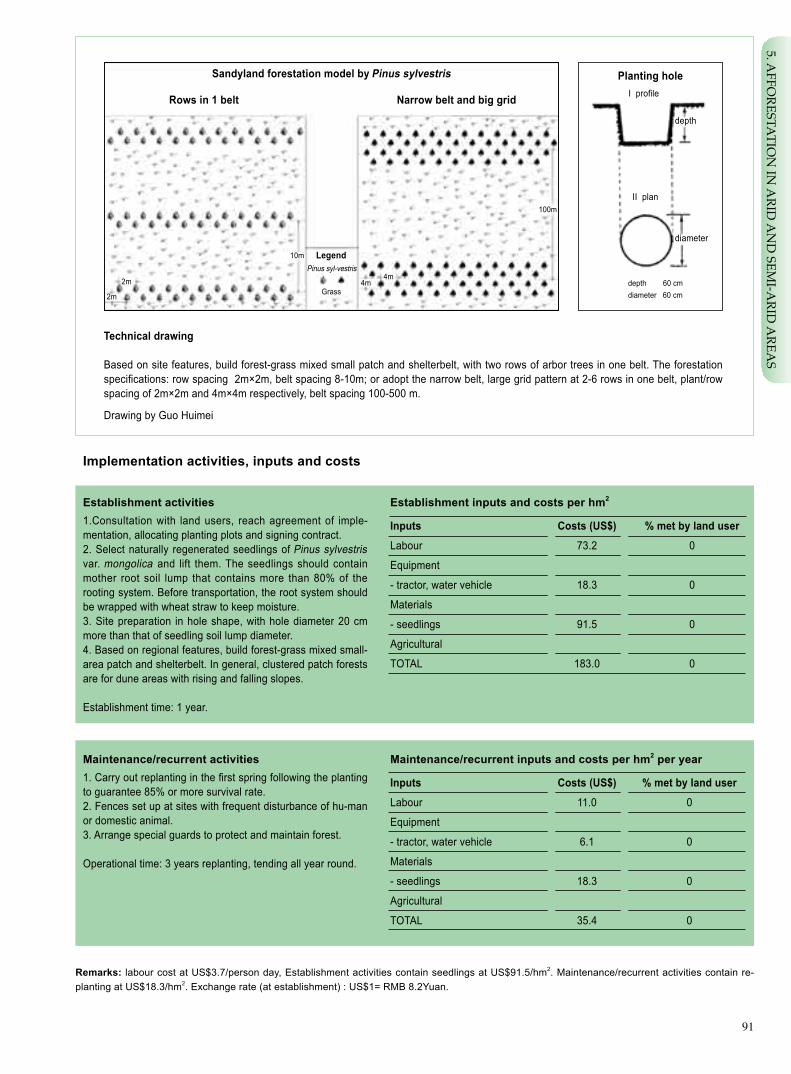
91
Implementationactivities,inputsandcosts
Establishmentinputsandcostsperhm2
Inputs Costs(US$) %metbylanduser
Labour 73.2 0
Equipment
- tractor, water vehicle 18.3 0
Materials
- seedlings 91.5 0
Agricultural
TOTAL 183.0 0
Establishment activities1.Consultation with land users, reach agreement of imple-mentation, allocating planting plots and signing contract. 2. Select naturally regenerated seedlings of Pinus sylvestris var. mongolica and lift them. The seedlings should contain mother root soil lump that contains more than 80% of the rooting system. Before transportation, the root system should be wrapped with wheat straw to keep moisture.3. Site preparation in hole shape, with hole diameter 20 cm more than that of seedling soil lump diameter.4. Based on regional features, build forest-grass mixed small-area patch and shelterbelt. In general, clustered patch forests are for dune areas with rising and falling slopes.
Establishment time: 1 year.
Remarks: labour cost at US$3.7/person day, Establishment activities contain seedlings at US$91.5/hm2. Maintenance/recurrent activities contain re-planting at US$18.3/hm2. Exchange rate (at establishment) : US$1= RMB 8.2Yuan.
Maintenance/recurrentactivities1. Carry out replanting in the first spring following the planting to guarantee 85% or more survival rate. 2. Fences set up at sites with frequent disturbance of hu-man or domestic animal. 3. Arrange special guards to protect and maintain forest.
Operational time: 3 years replanting, tending all year round.
Maintenance/recurrentinputsandcostsperhm2 per year
Inputs Costs(US$) %metbylanduser
Labour 11.0 0
Equipment
- tractor, water vehicle 6.1 0
Materials
- seedlings 18.3 0
Agricultural
TOTAL 35.4 0
Technicaldrawing
Based on site features, build forest-grass mixed small patch and shelterbelt, with two rows of arbor trees in one belt. The forestation specifications: row spacing 2m×2m, belt spacing 8-10m; or adopt the narrow belt, large grid pattern at 2-6 rows in one belt, plant/row spacing of 2m×2m and 4m×4m respectively, belt spacing 100-500 m.
Drawing by Guo Huimei
I profile
depth
diameter
depth 60 cmdiameter 60 cm
II plan
Planting holeSandyland forestation model by Pinussylvestris
Rows in 1 belt Narrow belt and big grid
Pinus syl-vestris
Grass2m
2m
4m
100m
4m
10m Legend
5. AFFO
RESTATIO
N IN
ARID
AN
D SEM
I-ARID
AREA
S

92
Key reference(s) [1] Inner Mongolia Forestry Department. Studies on forestation of Pinus sylvestris var. mongolica at different site conditions. Col-
lection of Technological Research Achievements in Inner Mongolia (2001-2005). 2006: 42-44[2] Inner Mongolia Forestry Department. Forestation Technology of Pinus sylvestris var. mongolica at Sandyland. 2001: 152-154
Contact person(s)Tian Lü, Inner Mongolia Forestry Survey and Design Institute. Tel: 0471-5953487. Email: [email protected]
Strengthens and →howtosustain/improve
Stable forest-grass community and good protection benefit → Further study the forest-grass arrangement pattern at different site conditions.
High adaptability and survival rate of the naturally regenerated seedlings → Study to improve seedling production quantity.
Weaknesses and → how to overcome
Seedling lifting causes soil and water erosion easily → Do not lift seed-lings in concentrated locations and back fill the earth after seedling lifting.
Assessment
- Operational cost is totally covered by proejct, and the proejct ecological benefits and long term economic benefits accure to the farmers and herds-men, who are therefore active to the proeject technology.
- In case if the operational cost to be covered by the farmers and herdsman, they do not accept.
Benefits/costsaccordingtolanduser Benefitscomparedwithcosts Short-term Long-term
establishment neutral very positive
maintenance/recurrent neutral very positive
Impacts of the technology
Productionandsocio-economicbenefits Productionandsocio-economicdisadvantages
+ + Adjust structure of agricultural and animal husbandry industries – Grazing income is reduced in short term period
+ Protect the pasture land and increase fodder produciotn
Socio-culturalbenefits Socio-culturaldisadvantages
+ +
Contribute to imporving awareness of local residents on ecology and promote social harmornous development None
Ecologicalbenefits Ecologicaldisadvantages
+ + + Fix sand, break wind, and curb desertification None
+ + Increase vegetation cover and improve micro environment
+ Increase biodiverstiy and protect ecosystem stability
Off-sitebenefits Off-sitedisadvantages
+ Reduce wind/sand harms and damages off-site None
Concludingstatements
The land users were neutral to the technology application. With the develop-ment process of recovered vegetation and increased economic benefit, the land users have become more active to the project.
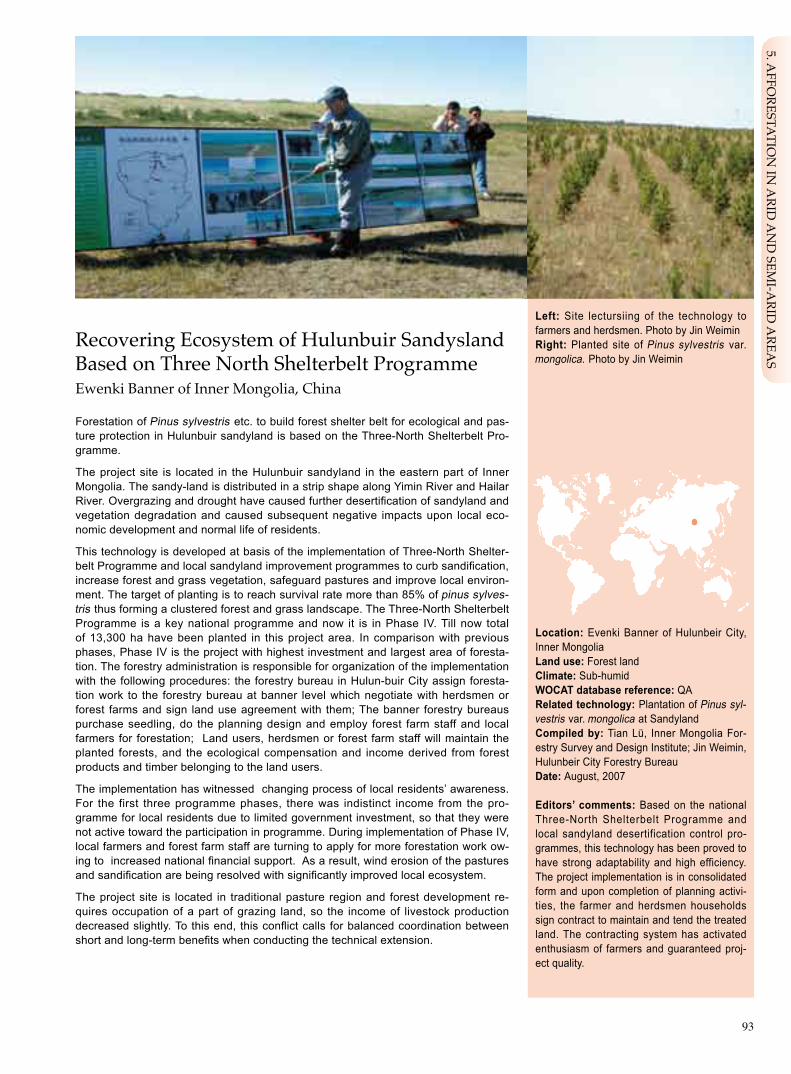
93
Recovering Ecosystem of Hulunbuir Sandysland Based on Three North Shelterbelt ProgrammeEwenki Banner of Inner Mongolia, China
Forestation of Pinus sylvestris etc. to build forest shelter belt for ecological and pas-ture protection in Hulunbuir sandyland is based on the Three-North Shelterbelt Pro-gramme.
The project site is located in the Hulunbuir sandyland in the eastern part of Inner Mongolia. The sandy-land is distributed in a strip shape along Yimin River and Hailar River. Overgrazing and drought have caused further desertification of sandyland and vegetation degradation and caused subsequent negative impacts upon local eco-nomic development and normal life of residents.
This technology is developed at basis of the implementation of Three-North Shelter-belt Programme and local sandyland improvement programmes to curb sandification, increase forest and grass vegetation, safeguard pastures and improve local environ-ment. The target of planting is to reach survival rate more than 85% of pinus sylves-tris thus forming a clustered forest and grass landscape. The Three-North Shelterbelt Programme is a key national programme and now it is in Phase IV. Till now total of 13,300 ha have been planted in this project area. In comparison with previous phases, Phase IV is the project with highest investment and largest area of foresta-tion. The forestry administration is responsible for organization of the implementation with the following procedures: the forestry bureau in Hulun-buir City assign foresta-tion work to the forestry bureau at banner level which negotiate with herdsmen or forest farms and sign land use agreement with them; The banner forestry bureaus purchase seedling, do the planning design and employ forest farm staff and local farmers for forestation; Land users, herdsmen or forest farm staff will maintain the planted forests, and the ecological compensation and income derived from forest products and timber belonging to the land users.
The implementation has witnessed changing process of local residents’ awareness. For the first three programme phases, there was indistinct income from the pro-gramme for local residents due to limited government investment, so that they were not active toward the participation in programme. During implementation of Phase IV, local farmers and forest farm staff are turning to apply for more forestation work ow-ing to increased national financial support. As a result, wind erosion of the pastures and sandification are being resolved with significantly improved local ecosystem.
The project site is located in traditional pasture region and forest development re-quires occupation of a part of grazing land, so the income of livestock production decreased slightly. To this end, this conflict calls for balanced coordination between short and long-term benefits when conducting the technical extension.
Left: Site lectursiing of the technology to farmers and herdsmen. Photo by Jin Weimin Right: Planted site of Pinus sylvestris var.mongolica. Photo by Jin Weimin
Location: Evenki Banner of Hulunbeir City, Inner MongoliaLanduse:Forest landClimate: Sub-humid WOCATdatabasereference:QARelated technology: Plantation of Pinus syl-vestris var. mongolica at SandylandCompiled by: Tian Lü, Inner Mongolia For-estry Survey and Design Institute; Jin Weimin, Hulunbeir City Forestry Bureau Date: August, 2007
Editors’ comments: Based on the national Three-North Shelterbelt Programme and local sandyland desertification control pro-grammes, this technology has been proved to have strong adaptability and high efficiency. The project implementation is in consolidated form and upon completion of planning activi-ties, the farmer and herdsmen households sign contract to maintain and tend the treated land. The contracting system has activated enthusiasm of farmers and guaranteed proj-ect quality.
5. AFFO
RESTATIO
N IN
ARID
AN
D SEM
I-ARID
AREA
S

94
Problem, objectives and constraints
Problem- Lack of effective mechanism to organize and mobilize herdsmen. - Extended forestry project takes a part of grazing land, leading to land use conflicts. - Herdsmen in lack of enthusiasm of participation.- Vegetation degradation and land desertification affects production and life.
Objectives- Coordination of different stakeholders and formation of effective technical extension mechanism. - Raising awareness of community on ecological protection. - Checking wind and fixing drift sand, adding forest vegetation to realize both ecological and economic targets.
Major Specification
Funds Limited local financing resources affected extension area of the technology.
Land use Conflict between Forest and pasture land use is out standing,because forestation occupies a part of pas ture land and affect herdsmn income.
Minor Specification
Management The forest land and pasture land are mixed up, and more animal husbandry activities are conducted, therefore forest protection and maintenance are dif ficult to be fully implemented.
Treatment
Central government provides more support and the local govern-ment makes available funds from multiple channels.
Government provides to herdsmen proper compensation.
Treatment
Intensify publicity, and set up award-punishment regime. Set up fence at vulnerable sites.
Constraints addressed
Differences in participation of men and women: Male labour takes about 80%; female labour takes about 20%.
Participation and decision making
Targetgroups
Land user Design staff Decision maker
Decisions on choice of the technology: Banner forestry bureau.Decisions on method of implementing the technology: Banner government. Approach designed by: City forestry experts.
Communityinvolvement
Phase Involvement Activities
Initiation Interaction Households participate in training, and sign contracts with government.
Planning Interaction Learn the technical method and finalize the planting plots with technicians.
Implementation Active Site preparation, planting and tending etc.
Monitoring/evaluation Interaction Offer observation data.
Research Passive Offer observation data.
Approach costs met by
State government 80%
Counterpart fund by city and bannergovernment 20%
TOTAL 100%

95
Extension and promotion
Training: The technical staff of the banner forestry work stations conducted training to land users by lectures, site demonstrations etc.. The training result is good.
Extension: The banner forestry work stations and township forestry work stations are responsible for technical extension, and the emphasis is made on seedling lifting technique, site preparation specifications, plant technique etc. The result is good.
Research: The city forestry research institute conducted research on establishment of artificial community Pinus sylvestris var. mon-golica and the sand fixation effect. This method has been applied in project and has produced benefits, thus herdsmen with pleasure accept this technology.
Importanceoflanduserights: At the beginning herdsmen households didn’t understand the project and technology, so they held indifferent attitude. Along with the raising benefits of project, their attitude has become positive. In general, land tenure has certain influence on project technology application.
Incentive
Labour:The banner forestry bureau organized forest farm staff and herdsmen to participate in project and paid for their labour input.
Inputs:Forestry bureau provides materials and machinery such as seedlings, tractors and water vehicles, the workers provide small facilities such as spades.
Credit: Bank provides loan to local government for purchasing seedlings.
Supportoflocalinstitutions:Local government being responsible for coordination and mobilization, holds positive attitude to the technology.
Long-term impact of incentives: Without above-mentioned incentives, the technology is hard to be implemented.
Organogram
The project task and financing plan is issued by State Forestry Administration (SFA) and deliver to local forestry units through Three-North Shelter-belt Programme.
State Forestry Administration
Banner Forestry Bureau City Forestry Institute
Three-North Shelterbelt Programme Bureau
Township Government andits Forest Farm
City Forestry Bureau
Households, Forest Farm Staff
5. AFFO
RESTATIO
N IN
ARID
AN
D SEM
I-ARID
AREA
S

96
Monitoringandevaluation
Key reference(s) [1] Inner Mongolia Forestry Department. Studies on forestation of Pinus sylvestris var. mongolica at different site conditions. Col-
lection of Technological Research Achievements in Inner Mongolia (2001-2005). 2006: 42-44[2] Inner Mongolia Forestry Department. Forestation Technology of Pinus sylvestris var. mongolica at Sandyland. 2001: 152-154
Contact person(s)Tian Lü, Inner Mongolia Forestry Survey and Design Institute. Tel: 0471-5953487. Email: [email protected]
Methods and indicators
Wind speed, amount of wind erosion.
Survey survival rate; sampling plot survey of community composition; survival rate of forest Pinus sylvestris var. mon-golica, forest and grass community composition.
Questionnaire and site survey of the acceptance of the technology by local residents.
Survey and calculate the agriculture/grazing economic benefits to the local community after proejct is implemen-tated several years later.
Survey the treated area and the changes related to land types.
Survey to find out the quantity of the land users and the structural changes.
Questionnaire and site survey of the area using the technology.
Monitored aspects
Bio-physical
Technical
Socio-cultural
Economic/production
Area treated
No. of land users involved
Management of approach
Strengthens and →howtosustain/improve
Extension efficiency is high → The extension capability of govern-ment can be strengthened further
Contracting system of forest land is favouring protection and main-tenance → Improve the land contracting system
Weaknesses and → how to overcome
Farmer participation level is low → Introducing participatory tools in the entire process
Impacts of the approach
Changesasresultofmonitoringandevaluation:At initial stage, due to less investment and limited benefits, the public enthu-siasm of participation was low. Along with investment increase and the benefit accumulated, the participation become popular.
Improved soil and water management: The management of forest land has been effectively strengthened.
Adoptionoftheapproachbyotherprojects/landusers:The method has been extended in neighboring areas.
Sustainability:Contracting for long period can bring certain profits. Land users without long-term support may continue to adopt the technology.
Concludingstatements

97
Farmland Shelterbelt on Dryland Aohan Banner of Inner Mongolia, China
The shelterbelt in shape of grid can be established on dryland (rain-fed cropland) without irrigation.
The technological demonstration plot is located in Aohan Banner, the eastern part of Inner Mongolia and the south of Horqin Desert. Hills and sandlot dominate this area. The demonstration plot is a semi-arid area with poor natural conditions. This area is featuring shortage of both surface and ground water resources, so most farmlands are rain fed. The crops often suffer from gust and cold wave. Sometimes there is no harvest at all. Establishment of shelterbelts is an essential, imperative and necessary measure to ensure stable and high yield of farming products.
The key points of the technique are as follows: (1) Site selection – hillside land or sand-covered cropland with slope less than 15o. (2) Shelterbelt configuration – nar-row belt, small grid with ventilation configuration. Main belt is has three rows of trees at spacing 2mx2m; the ancillary (side) belt has two rows of trees at spacing 2mx2m. The spacing of main belts is 300m and that of ancillary belts is 400-500m. The main belt should be arranged perpendicular to prevailing wind direction and the ancillary belts should be perpendicular to the main belts. (3) Species selection - P. X Simopy-ramidalis chon-Lin CV, Populus simonii × P. nigra and Populus × beijingensis W. Y. Hsu or other tolerant and fast-growing poplars species or varieties. (4) Site prepara-tion – conduct site preparation in rainy season one year earlier before planting in semi-underground or level trough form. (5) Seedling preparation – dig out the seed-lings several days before planting date and sufficiently watering before lifting. Wet soil should be used to keep moisture of the roots of the lifted seedling and wrap the roots with wheat straw or plastic cloth when the seedlings are to be shipped. Soak them completely in water for 48h before planting. (6) Planting – April and May are best planting seasons. Place the seedling upright in the hole and backfill soil in lay-ers and tread it firmly in each layer. Water the seedling sufficiently after planting and make 20-30cm high drought-resistant soil pile surrounding the seedling. (7) Main-tenance measures – build wall at 1m distance to trees of edge row to prevent detri-ment by human or livestock.
The farmland shelterbelt in Aohan Banner has produced good economic and eco-logical benefits. The observation indicates that farmlands guarded by the shelterbelt have less wind erosion and increased resistance to natural disasters and additional 10% of crop output increased. As revealed in some estimation, each hectare of for-est can increase five cubic meters of growing stock. Such remarkable predictable economic benefits promote great enthusiasm of farmers to participate in the project. At present, almost all dry lands in Aohan Banner have had farmland shelterbelts.
Left: Bird’s-eye view of farmland shelterbelt on dryland. Photo by Ding RongRight: Close shot of farmland shelterbelt on dryland. Photo by Li Xianyu
Location: Aohan Banner, Inner MongoliaTechnologyarea: 2000km2
SWCmeasure: VegetationLanduse:CroplandClimate: Sub-humid WOCATdatabasereference:QTRelated approach: Farmland Shelterbelt on Dryland, Led by GovernmentCompiled by: Li Chunying, Inner Mongolia Forestry Department; Tian Lü, Inner Mongolia Forestry Survey and Design Institute.Date: August, 2007
Editors’ comments: This technology is suitable for hill land and sand-covered rain-fed cropland. It needs less investment but produces good protection effect. At the same time, the forest belt at mature stage can be felled for timber use to realize ecological and economic benefits. Now, this technology has been widely extended in areas with serious sand harm of Inner Mongolia autonomous region. This technology has good potential to be adopted for similar areas.
5. AFFO
RESTATIO
N IN
ARID
AN
D SEM
I-ARID
AREA
S

98
very steep (>60)steep (30–60)hilly (16–30)rolling (8–16)moderate (5–8)gentle (2–5)flat (0–2)
Growing season: 150 days in succession, from April to September Soil fertility: moderate Soiltexture:moderate (loamy)Surfacestoniness: no Topsoilorganicmatter:moderate (1%-3%) Soil drainage: moderateSoil erodibility: high
>4000 >4000 3000–4000 3500–4000 2000–3000 3000–3500 1500–2000 2500–3000 1000–1500 2000–2500 750–1000 1500–2000 500–750 1000–1500 250–500 1000–500 <250 <500
Soil depth (cm)
0–20 20–50 50–80 80–120 >120
Classification
LanduseproblemsSerious wind erosion; crops are easily affected by extreme weather conditions; land economic benefits is low in general.
Landuse Climate Degradation SWCmeasure
Cropland: Sub-humid Wind Biological potato erosion measurer
Technicalfunction/impactmain: - reduce wind erosion - prevent sand burials - prevent the crops from mechanical or freezing harms
Environment
NaturalEnvironment
Averageannualrainfall(mm) Altitude(ma.s.l.) Landform Slope(%)
Landuserights:individual Land ownership: collective Market orientation: self use Leveloftechnicalknowledgerequired:moderate for technical extensionists and low to land userImportance of off-farm income: less than 10% of the total income
Humanenvironment
Mixedlandperhousehold(hm2)
<1 1–2 2–5 5–15 15–50 50–100 100–500 500–1000 1000–10000 >10000
secondary: - reduce evaporation - improve micro climate of the farmland
ridges
ridgeshill slopes
foot slopesvalley floors
mountain slopes
plains/plateaus

99
Establishmentinputsandcostsperhm2
Inputs Costs(US$) %metbylanduser
Labour 54.9 100
Equipment
- tractor, water trasport vehicle 36.6 0
Materials
- seedling 609.8 0
Agricultural
TOTAL 701.3 7.8
Implementationactivities,inputsandcosts
Establishment activities1. Preparation investigation: determine location and techni-cal methodology. 2. Farmer and government sign afforestation contract. 3. Planting design. 4. Selection of tree species. 5. Site preparation. Done at rainy season one year before planting. 6. Seedlings.7. Planting. Put seedling upright the planting hole, fill in earth, tread and water earth. 8. Maintenance protection. One meter away from the trees of edge row, dig a gully with 1m wide at upper edge, 0.8m wide bottom edge and build walls aside the gully to avoid human or domestic animal damages. Three years of mainte-nance tending.
Establishmet time: 1 year.
Technicaldrawing
Pattern design: spacing: 2m×2m, two lines belt with grid size: 300m×500m or 500m×500m.
Semi-underground site preparation: 4-6m long, 1 m wide, 0.5m deep; In-side prepare the planting pits with size 0.6m×0.6m×0.6m.
Drawing by Guo Huimei, Inner Mongolia Forestry Monitering and Planning Insti-tute.
Maintenance/recurrentactivities1. Artifial weeding between forest belts, twice a year water-ing in spring and autumn. 2. Supplemental planting In spring of the year following the initial plating.3. Arrange special guards for protecting shelterbelts.
Maintenance/recurrentinputsandcostsperhm2 per year
Inputs Costs(US$) %metbylanduser
Labour 36.6 100
Equipment
- tractor, water trasport vehicle 18.3 0
Materials
- seedling, pesticide 60.0 0
Agricultural
TOTAL 114.9 31.85
Remarks: Labor price at US$3.7/peron day; seedlings used during maintenance are for replanting; Exchange rate (at establishment): US$1= RMB 8.2 yuan.
Model of rain-fed farmland shelterbelt
prevailing wind(northwest)
legendtreeShrubm
m m
m
diameter 60 cm depth 60 cm
60cm
50cm
500cm
100cm
5. AFFO
RESTATIO
N IN
ARID
AN
D SEM
I-ARID
AREA
S

100
Key reference(s) [1] Inner Mongolia Forestry Departmetn. Technique of farmland shelterbelt establishment on rain-fed farmland: Appropriate for-
estry technology. 2001: 116-118[2] Desertification Combating and Management Center of State Forestry Administration. Applied technology and pattern of deser-
tification control in China. Beijing: China environmental science press, 2001
Contact person(s)Tian Lü, Inner Mongolia Forestry Survey and Design Institute. Tel: 0471-5953487. Email: [email protected]
Strengthens and →howtosustain/improve
Protection performance is good → Further extension.
Have certain economic benefits → Explore possibility of plant-ing cash trees for higher output.
Weaknesses and → how to overcome
Forest belt has effect on neighboring crops → Introduce proper species and conduct root cutting to mitigate the effect.
Single tree species adopted → Introduce more forest species suitable for shelterbelt.
Assessment
Acceptance/adoption- With existing incentive mechanism, most households accept this technology. - Without incentive mechanism most households do not accept this technology.- If the comparative benefit of farmland shelterbelt is high, farmer households can accept the technology.
Benefits/costsaccordingtolanduser Benefitscomparedwithcosts Short-term Long-term
establishment neutral very positive
maintenance/recurrent neutral very positive
Impacts of the technology
Productionandsocio-economicbenefits Productionandsocio-economicdisadvantages
+ + +
Improve the growth environment of the crops and enssure –
The trees have some effect on neighboring crops, and high and stable output of farmaland thus reducing crop output
+ +
Increase timber standing volume and generate economic income
Socio-culturalbenefits Socio-culturaldisadvantages
+
Enrich farmers’ knowledge of ecologcal improvement None and protection
Ecologicalbenefits Ecologicaldisadvantages
+ + Reduce wind erosion – None
+ Prevent sand burials
+ Reduce evaporaion
Off-sitebenefits Off-sitedisadvantages
+ + +
Reduce sand dust weather days, absorbing carbon dioxide None
and releasing oxygen
Concludingstatements
The farmland shelterbelt brings to farmer households direct benefit, and government provides considerable subsidy, so the enthusiasm of farmer household is very high.

101
Farmland Shelterbelt on Dryland, Led by GovernmentAohan Banner of Inner Mongolia, China
Farmland shelterbelt establishment on dryland is organized by Banner (county) gov-ernment and implemented by forestry administrations.
Farmland shelterbelt with a history of decades in Inner Mongolia is a shelter forest planted around farmland to prevent wind and chilly harms. Many forestation models have been built up for various locations through years of practice in the light of local conditions, such as Taiping model of Chifeng City, Zhandanzhao model of Erdos City, etc. The Aohan farmland shelterbelt model is the results of summing up achieve-ment of technicians and farmers in their long-term practices.
As early as in 1950s, Aohan farmers started planting poplars surrounding farmland to counter the sand-storm and cold wave and achieved obvious success. The for-estry administration of Chifeng City has summed up their experience in shelterbelt construction and proposed a narrow belt and small grid model. Shelterbelt building in 1950s and 1960s experienced rapid development. In 1990s, along with national key ecological projects implemented, farmland shelterbelt establishment in Aohan en-tered an ex-press track and shelterbelt network has basically formed throughout the Banner.
Aohan Banner shelterbelt construction has been led by the government with the forestry bureau responsible for planning and provision of technical service. Town-ship government is responsible for organization of implementation and signing con-tracts with local farmers for operation of shelterbelt. Technology dissemination has followed principle of “uniform planning, uniform construction, uniform management and household contracting system”, including (1) Banner government undertake an educational campaign on benefits of shelterbelt and demonstration in order to gain farmers recogni-tion. According to official planning, the land for shelterbelt should be reserved based on signed contracts; (2) the forestry administration prepares project implementation plan and provides technical service ; (3) township government loan is used forestablishment and maintenance of farmland shelterbelt, and a special team is assigned for planting shelterbelt trees and supplementary planting in three years; and (4) the township government organizes special forest guards to protect the established forest.
15 years later after its establishment, regeneration felling may be conducted and the income from timber harvest is distributed in 4:3:3 ratio, i.e. 40% to village committee, 30% to forest guards and 30% to farmers, thus all stakeholders can enjoy benefits. It is a good approach to protect shelterbelt forest. The farmers have recognized farmland shelterbelt and its economic benefits. Farmers have played positive role in construction of farmland shelterbelt. At present, there are 200,000hm2 of farmlands encircled by shelterbelt and satisfactory ecological and economic benefit has been achieved.
Left:Farmland shelterbelt net on dryland. Photo by Li Chunying Right: Farmland shelterbelt for rain-fed crop. Photo by Li Xianyu
Location: Aohan banner, Inner Mongolia Landuse:Forest land, farmlandClimate: Semi-arid WOCATdatabasereference:QARelated technology: Farmland Shelterbelt on DrylandCompiled by: Tian Lü, Inner Mongolia For-estry Survey and Design Institute; Li Chuny-ing, Inner Mongolia Forestry DepartmentDate: August, 2007
Editors’ comments: This technology has shown obvious benefit in Aohan banner, where the project was implemented by unified planning and professional team, and estab-lishment quality is well guaranteed. All stake-holders share the benefits. This technology is warmly welcomed by farmers and herdsman. As a whole, the progress of project is satis-factory. The technology has a broad impact on surrounding area.
5. AFFO
RESTATIO
N IN
ARID
AN
D SEM
I-ARID
AREA
S

102
Problem, objectives and constraints
Problem- The short term benefit is low. - Poor awareness of the farmers on the project benefits.- The expertise of the professional teams awaits further improvement.
Objectives- Form effective technical extension mechanism.- Improve households’ awareness on ecological protection.- Increase economic income of project participants.
Differences in participation of men and women: Both men and women are active in participation. More man labors are used.
Participation and decision making
Targetgroups
Land user Designer Decision maker
Decisions on choice of the technology: Government of banner (county) and township.Decisions on method of implementing the technology: Banner forestry bureau.Approach designed by: Banner forestry experts.
Communityinvolvement
Phase Involvement Activities
Initiation Interactive Governmental managers and technicians put forward tentative ideas for community meeting discussion. Sign contract with land owners.
Planning Interactive Settle precise location of sites for farmers.
Implementation Active Attend technical training courses, participate in site preparation, planting and later stage management.
Monitoring/evaluation Passive Households offer observation data.
Research Passive Households offer observation data.
Major Specification
Economic aspect The growth period of shelterbelt is long and economic profit of the initial stage is low, farmers’ enthusiasm is not high.
Law and policy Annual allowable cut quota limits regeneration of trees of shelterbelt.
Minor Specification
Organizational management Inadequate publicity and training.
Treatment
At initial stage, proper subsidy is needed.
Increase annual allowable cut quota.
Treatment
Banner government allocates special funds for publicity and training.
Constraints addressed
Approach costs met by
Township government loan 100%
TOTAL 100%

103
Extension and promotion
Training:Banner forestry station technicians are responsible for training in forms of lecturing and site demonstration. The training topics are benefits of shelterbelts, key technique etc. The training effect to farmers is good.
Extension: Extension is undertaken by the township government with support of banner forestry bureau. The extension is under-taken in the form of demonstration at the land reserved by contrct. The effect is good.
Research: Research is done by banner forestry bureau and city forestry institute. Related research covers technique establishment of farmland shelterbelts, protection benefit monitoring, increased agricultural crops by shelterbelt etc. Results of research play posi-tive role in project benefits.
Importanceoflanduserights:The land is reserved according to contracts, and it is owned by collectives. It has no negative im-pact on technology application.
Incentive mechanism
Labour:Labor force is organized by the township government and paid at market price, normally RMB 30 Yuan per person day.
Inputs:All project costs such as seedlings, machinery and labor are paid by the township governmental loan.
Credit: Bank provides interest-subsidized or low interest loan.
Supportof local institutions:Technology application raised households’ favor for the forestry bureau and township government, also strengthened the organizational capability of the governmental organizations.
Long-term impact of incentives: For long term, incentive mechanism is positive to the technological application because the incen-tives encourage more and more farmers and herdsman to participate in the project. Without above-mentioned incentive mechanism, the application is more difficult.
Organogram
The technical extension is jointly organized by the banner government and the township government.
Farmers
Aohan Banner Government
Township Government Banner Forestry Bureau
5. AFFO
RESTATIO
N IN
ARID
AN
D SEM
I-ARID
AREA
S

104
Monitoringandevaluation
Methods and indicators
Measure the wind speed and temperature inside and outside the farmland shelterbelts.
Investigate survival rate and preservation rate, tree growing potential and forest maintenance condition.
Sampling check of the role of farmland shelterbelt in improving agricultural production environment, raising techni-cal level and improving the life quality of farmers and herdsmen.
Conduct statistics of grain production, timber output and farmer/herdsman income increase after the farmland shelterbelt is established.
Sampling check of the farmland shelterbelt area and the preservation condition.
Sampling survey of land users quantity and their structure.
Questionnaire and site survey to lower-level management by higher level department.
Monitored aspects
Bio-physical
Technical
Socio-cultural
Economic/production
Area treated
No. of land users involved
Management of approach
Strengthens and →howtosustain/improve
Extension efficiency is high → Further strengthening extension capability of the government.
Take incentive measures → Enlarge technology coverage.
Weaknesses and → how to overcome
The level of farmer participation is low → Application of participatory tools.
Economic return period is long → Considering proper compensation at early stage of establishment.
Impacts of the approach
Changesasresultofmonitoringandevaluation:At initial stage of the project implementation, the households did not see any direct benefits, so they held negative attitude to the project. With the benefit appearing, the enthusiasm of households recovered and became higher.
Improved soil and water management: Wind erosion of soil controlled and soil fertility increased.
Adoptionoftheapproachbyotherprojects/landusers:technology is adopted also by the department of animal husbandry.
Sustainability:Because of good ecological and economic benefits of the project, the land users will use the technology continu-ously even without long term support.
Concludingstatements
Key reference(s) [1] Inner Mongolia Forestry Departmetn. Technique of farmland shelterbelt establishment on rain-fed farmland: Appropriate for-
estry technology. 2001: 116-118[2] Desertification Combating and Management Center of State Forestry Administration. Applied technology and pattern of deser-
tification control in China. Beijing: China environmental science press, 2001
Contact person(s)Tian Lü, Inner Mongolia Forestry Survey and Design Institute. Tel: 0471-5953487. Email: [email protected]

105
Left: deep planted forest at Dulan County. Qinghai. Photo by Qi ChengdeRight: vigorous forest grown on the sand land. Photo by Qi Chengde
Location: Dulan County, Qinghai ProvinceTechnologyarea:107km2
SWCmeasure:Vegetation and engineeringLanduse: Sandy land, degraded grazing landClimate: Semi-arid/arid WOCATdatabasereference: QTRelated approach: Deep Planting with Pop-lar Cutting at High Cold DesertCompiled by: Qi Chengde, Qinghai Provin-cial Forestry BureauDate: September, 2007
Editors’ comments: This technology can raise forestation survival rate without irriga-tion to effectively increase vegetation for wind breaking and shift sand fixing. This technol-ogy applies at the high and cold sandy land of desert ecosystem. In Hainan prefecture (Guinan County, Gonghe County) and Haixi prefecture (Dulan County, Wulan County) of Qinghai,10700 hm2. has been planted for demonstration and the survival rate reached 90%, and the sandy land vegetation cover reached over 10% which efficiently alleviated the desertification expansion speed.
Deep Planting of Poplar at High Cold Arid Sandy LandDulan County of Qinghai Province, China
Poplar cuttings are adopted for deep planting at high altitude cold plateau desert to remarkably increase survival rate and improve psammophilous vegetation for sand fixation and wind breaking.
The technology demonstration zone is located in Dulan County, Qinghai Province, southeastern part of Qaidam Basin. The county has 3 towns and 6 townships, 75,000 in population (55,600 farmers and herdsmen), a total area of 48,392km2. It is in a temperate zone desert, with short hot summer, dry climate, low precipitation (37.9-296mm) that concentrated June thru September, 70-90days of frostfree period, 2.27 million hectares of natural meadow (1.66 million ha usable), 623,000hm2 of de-sertified grassland and 12,400hm2 of farmland. With deteriorating wind erosion and desertification some farmland and roads are threatened.
Technical implementation steps (1) Cutting preparation – select health branches of 1-2 years old of 8-15 years old Populus cathayana. The cuttings should be with 3cm in diameter and free of pest or disease. Make cuttings to approximately 1.5m long. (2) Cutting treatment – soak the cuttings in flowing water for about 40days until bark turns to white with light yellowish protrusion, use ABT rooting powder for treatment. (3) Site preparation – start site preparation in mid May, 1.5mx2m in spacing, 0.8-1m in hole depth. Remove dry sand from the hole before preparation. (4) Planting – planting depth is 1m and keep the trunk 50cm above the ground level. Plant the cuttings immediately after the planting pit is dug. Drill steel of 3cm diameter may be used to dig the hole for cutting forestation. (5) Set sand barrier – for small patch of drifting sand, use gravel or straw to set 2mx2m grid sand barrier and sow seeds of Caragana Korshinskii Kom, Artemisia filifolia or deeply plant trees in the grid.
This technology is successfully adopted for 10,700hm2. in Hainan Prefecture (Guinan, Gonghe counties) and Haixi Prefecture (Wuland, Dulan counties) increasing plant survival rate from 60% to more than 90% . It promotes forest and grass vegetation growth without irrigation, reduces dune movement and wind/sand harms.
5. AFFO
RESTATIO
N IN
ARID
AN
D SEM
I-ARID
AREA
S

106
Classification
Landuseproblems
Landuse Climate Degradation Measure
Land for Grazing Semi–arid Wind erosion Management Mechanical Biologicalforestaion pasture measure measures measures
Technicalfunction/impactmain: - use deep ground moisture to raise forestation survival rate - fix drifting sand - add vegetation cover
Environment
NaturalEnvironment
Averageannualrainfall(mm) Altitude(ma.s.l.) Landform Slope(%)
very steep (>60)steep (30–60)hilly (16–30)rolling (8–16)moderate (5–8)gentle (2–5)flat (0–2)
Growing season: 90 days in succession, from June to September Soil fertility: low Soiltexture:coarse sandySurfacestoniness: moderate (plenty of loose gravel) Topsoilorganicmatter:low (<1%)Soil drainage: moderateSoil erodibility: very high
>4000 >4000 3000–4000 3500–4000 2000–3000 3000–3500 1500–2000 2500–3000 1000–1500 2000–2500 750–1000 1500–2000 500–750 1000–1500 250–500 1000–500 <250 <500
Soil depth (cm)
0–20 20–50 50–80 80–120 >120
Landuserights:collective or individual Land ownership: collective Market orientation: self use Levelof technicalknowledgerequired:moderate for the technical extensionists and low to land users Importance of off-farm income: 10%-50% of total income
Humanenvironment
Mixedlandperhousehold(hm2)
<1 1–2 2–5 5–15 15–50 50–100 100–500 500–1000 1000–10000 >10000
secondary: - reduce wind speed - protect farmland and pasture
ridges
ridgeshill slopes
foot slopesvalley floors
mountain slopes
plains/plateaus

107
Implementationactivities,inputsandcosts
Establishmentinputsandcostsperhm2
Inputs Costs(US$) %metbylanduser
Labour 89.88 0
Equipment
- spade, steel rod, transport vehicles etc. 39.35 5
Materials
- seedlings, gravel, crop straw 299.6 0
Agricultural
- pesticide, grass seeds, ABT etc 20 0
TOTAL 448.83 0
Establishment activities1. Cutting preparation In March when the poplar sap start flowing, identify 8-15 years old Populus cathayana for prepa-ration of 1.5 meters long, diameter over 3 cm cuttings from the 1-2 years old vigorous healthy branches without incidence of pests or diseases. In early April put the prepared cuttings into running water for soaking of about 40 days around to see appearance of the bark surface in white color.2. Pre-planting treatment. Use 0.1% density mg/L ABT for treatment of the poplar cuttings .3. Planting. Digging planting pit and plant right afterwords. The pit is 0.8- 1 metre in depth. The pit can also be drilled with steel rod at about 3 cm diameter for inserting afforestation.
Maintenance/recurrentactivities1. Management (enclosure protection, forest patrolling, pest/disease prevention and control).The forestation land should install iron wire fence and arrange community patrolling workers to protect the forest. The local forestry sector should offer proper subsidy for the mainte-nance while the pest/diseases control should be managed by local forestry bureau, which has to provide working facilities and medicament, and labor is offered by land users. 2. Maintenance (supplementary planting, enclosure protec-tion).For the sites with planting survival rate less than 70%, supple-mentary planting should be done in the following year; For the first 5 years following the planting, timely maintaining repair should be conducted to the fence to prevent forest damages from domestic animals.
Maintenance/recurrentinputsandcostsperhm2 per year
Inputs Costs(US$) %metbylanduser
Labour 87.67 0
Equipment
- spade, steel rod, transport vehicles etc. 0
Materials
- seedlings, gravel, crop straw 130.52 0
Agricultural
- pesticide, grass seeds, ABT etc 20 0
TOTAL 238.19 0
Remarks: For establishment, poplar seedlings US$299.6, site preparation and planting 45 person day hm2 at RMB 15 yuan/person day; Technical maintainance and operations include tending, supplementary plating, pest managment, fence protection, the costs levels: supplementary planting inc-luding seedling US$150.52 /yr (for designed density 220 plants, supplementary planting rate of 30%), other US$ 87.67.
1.5m
2m0.8-1.0m
0.5m
ProfileofPoplardeepplanting Spacing of Poplar deep planting
Technicaldrawing
Left: Profile of Poplar deep planting
Right: Spacing of Poplar deep planting
Drawing by Qi Chengde
5. AFFO
RESTATIO
N IN
ARID
AN
D SEM
I-ARID
AREA
S

108
Assessment
Acceptance/adoption
Benefits/costsaccordingtolanduser Benefitscomparedwithcosts Short-term Long-term
establishment very positive very positive
maintenance/recurrent very positive moderate
Impacts of the technology
Productionandsocio-economicbenefits Productionandsocio-economicdisadvantages
+ + + Wind breaking and sand fixing, protecting farmland and grazing land None
+ + Promote rural and grazing area development
Socio-culturalbenefits Socio-culturaldisadvantages
+ + Add knowledge of desertification control None
Ecologicalbenefits Ecologicaldisadvantages
+ + + Reduce wind speed and reduce wind eroison None
+ + Reduce sand and dust storms
+ + Improve ecological environment
Off-sitebenefits Off-sitedisadvantages
+ + + Reduce sandy weather days None
Concludingstatements
Key reference(s) [1] Forestry ecological improvement and the operational patterns in China. Beijing: China Forestry Publication House, 2003[2] Du Qilin, Xu Shengwang. Preliminary study report of forestation in Qaidam Gonghe Basin. Forestry Science and Technology,
2006 (5)
Contact person(s)Qi Chengde, Qinghai Provincial Forestry Bureau. Tel: 0971-6365120. Email: [email protected]
Strengthens and →howtosustain/improve
Notable effect in fixing drifting sand → Enlarge technological ap-plication area.
Reduce wind speed → Also meanwhile add bushes and grass for higher vegetation cover.
No irrigation → Study the moisture equilibrium, design reason-able afforestation density to prevent premature decline of the established forest.
Weaknesses and → how to overcome
Wind and drifting sand affected the planting survival rate → Install small grids in advance at areas of serious sandy harms.
Pure poplar forest easily suffer from pests/diseases → After the drifting sand is fixed, plant psammophytes bushes in diversity.
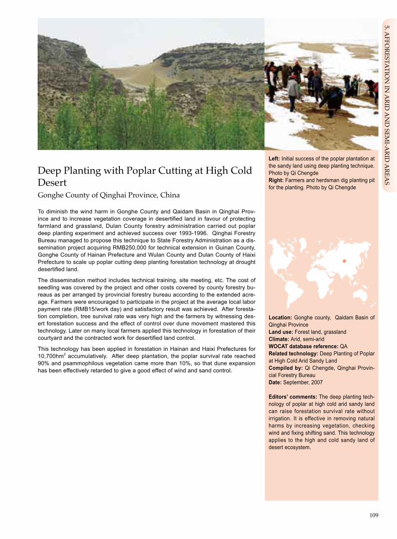
109
Deep Planting with Poplar Cutting at High Cold DesertGonghe County of Qinghai Province, China
To diminish the wind harm in Gonghe County and Qaidam Basin in Qinghai Prov-ince and to increase vegetation coverage in desertified land in favour of protecting farmland and grassland, Dulan County forestry administration carried out poplar deep planting experiment and achieved success over 1993-1996. Qinghai Forestry Bureau managed to propose this technique to State Forestry Administration as a dis-semination project acquiring RMB250,000 for technical extension in Guinan County, Gonghe County of Hainan Prefecture and Wulan County and Dulan County of Haixi Prefecture to scale up poplar cutting deep planting forestation technology at drought desertified land.
The dissemination method includes technical training, site meeting, etc. The cost of seedling was covered by the project and other costs covered by county forestry bu-reaus as per arranged by provincial forestry bureau according to the extended acre-age. Farmers were encouraged to participate in the project at the average local labor payment rate (RMB15/work day) and satisfactory result was achieved. After foresta-tion completion, tree survival rate was very high and the farmers by witnessing des-ert forestation success and the effect of control over dune movement mastered this technology. Later on many local farmers applied this technology in forestation of their courtyard and the contracted work for desertified land control.
This technology has been applied in forestation in Hainan and Haixi Prefectures for 10,700hm2 accumulatively. After deep plantation, the poplar survival rate reached 90% and psammophilous vegetation came more than 10%, so that dune expansion has been effectively retarded to give a good effect of wind and sand control.
Left: Initial success of the poplar plantation at the sandy land using deep planting technique. Photo by Qi Chengde Right: Farmers and herdsman dig planting pit for the planting. Photo by Qi Chengde
Location: Gonghe county, Qaidam Basin of Qinghai ProvinceLanduse:Forest land, grasslandClimate: Arid, semi-arid WOCATdatabasereference:QARelated technology: Deep Planting of Poplar at High Cold Arid Sandy LandCompiled by: Qi Chengde, Qinghai Provin-cial Forestry BureauDate: September, 2007
Editors’ comments: The deep planting tech-nology of poplar at high cold arid sandy land can raise forestation survival rate without irrigation. It is effective in removing natural harms by increasing vegetation, checking wind and fixing shifting sand. This technology applies to the high and cold sandy land of desert ecosystem.
5. AFFO
RESTATIO
N IN
ARID
AN
D SEM
I-ARID
AREA
S

110
Problem, objectives and constraints
Problem- The sand and dust storm in arid areas of western China is a serious land degradation form. - The shifting dune often buries farmland, grassland and even villages as well as infrastructure facilities such as highway. - However, due to the lack of effective organization and technical measures and direct economic project benefits, the local partici-
pation enthusiasm is low.
Objectives- Form effective technology extension mechanism. - Curb dune flow and improve ecological condition. - Raise community’s awareness in ecological protection. - Raise community’s participation level. - Check wind, fix shifting sand and reduce harms.
Constraints addressed
Major Specification Treatment
Economic aspect Land users short of fund for treating degraded land that Government offers free seedlings and subsidizes isdegraded, without benefit in short period, so the farmers and subsidizes labor input. herdsman are not willing to make investment.
Minor Specification Treatment
Policy and law Tending is necessary after the planting including fence installation Formulate sandy area vegetation protection methods. and formulation of tending and maintenance measures.
Participation and decision making
Targetgroups
Land user Design staff Extensionists
Decisions on choice of the technology: Proposed by the sand control technician of local forestry department and to be selected by local community.Decisions on method of implementing the technology: Forestry expert and land users approve the technical route.Approach designed by: Land users and local technicians of sand control.
Communityinvolvement
Phase Involvement Activities
Initiation Interaction Demand investigation, training, selection of sandified land treatment method.
Planning Interaction Decide work scale, implementation site plot.
Implementation Active Offer labor to plant and to install enclosure fence.
Monitoring/evaluation Self motivated Inspection check tree survival condition and report to local forestry department.
Research Passive Research work mainly undertaken by the county forestry technicians.
Differences in participation of men and women: More male labor in spring and more female labor in summer and autumn.
Approach costs met by
Government 95%
Farmer and herdsman 5%
TOTAL 100%

111
Extension and promotion
Training: Training topics include planting pattern design, plot planning. Trainees are township forestry technicians to guarantee good training effect. The training of planting technology and maintenance protection measures are mainly for farmers and herdsmen, and its training effect is moderate. The forms of training include: the township technicians adopt indoor lectures and teaching, the villag-ers were learning on the spot.
Extension: Through the above methods especially guidance and training on-the-spot, the poplar deep planting technology is intro-duced to farmers and herdsmen for application at the high and cold arid sandy land plots. For the extension work, the two key tech-nical issues are qualified seedlings and deep planting. Extension is done mainly by township or county forestry stations. Following the implementation, the technical extensionists should have interview with farmers and herdsmen and assess the extension results especially the forest survival rate, and to deal with possible problems.
Research: The technical extension work stations of the provincial forestry bureau and forestry stations of county forestry bureau work together to study the planting patterns and tree species selection etc.
Importanceoflanduserights:The land owner needs to agree to treat their degraded land.
Incentive mechanism
Labour:Labour is paid, at the standard of RMB15 Yuan/work day.Inputs:The input include poplar cuttings and vehicles (tractors) which will be provided by the project financing. Planting tools (spades, drill rods) are from villagers.
Credit: No credit is used.
Supportoflocalinstitutions: The project activity promoted capacity building of local forestry organizations and enhanced govern-mentfarmer/herdsman relationship.
Long-term impact of incentives: The knowledge of farmers and herdsmen for environment was expanded, and they can get benefit from the project activity of treating degraded land.
Organogram
The provincial forestry bureau incorporates the technical extension into project work plan and provide funds based on investigation results. County and township forestry bu-reaus are responsible for project design and technical supervision. Demonstration vil-lages organize villagers to participate in the project activities. Villagers put forward their demands.
In the course of implementation, the de-mands of villagers were reported to the up-per level forestry administration up to provin-cial forestry bureau.
Provincial Forestry Bureau
Provincial Forestry (or Envir. OnmentalProtection) Bureau
Town Forestry Work Station
Demonstration Village
Farmers and Herdsman
5. AFFO
RESTATIO
N IN
ARID
AN
D SEM
I-ARID
AREA
S

112
Monitoringandevaluation
Monitored aspects Methods and indicators
Bio-physical Site measurement, indicator: wind speed, rainfall etc. as well as desertification area and expansion speed.
Technical For tree survival rate, forestation preservation rate, sample spot-checking once a year. Make statistics of survival rate. From the second year after planting, investigate the forest preservation rate.
Socio-cultural Note down the major local cultural activities.
Economic/production Record upon visit survey to see whether local land owners’ income increase or decrease.
Area treated Use GPS to measure treated acreage.
No. of land users involved Note down by tabulation the concerned land users and make statistics.
Management of approach Establish files and build up working regulations.
Impacts of the approach
Changesasresultofmonitoringandevaluation:To address the threats of high wind speed, quick desertification expansion, it is necessary to use grass grid or clay sand barrier to fix the sand at begining, and then plant the poplar deeply.
Adoptionoftheapproachbyotherprojects/landusers:This technology is used in the easily dersertified area in western Qing-hai province.
Sustainability:Through demonstration and continued improvement of species diversity to improve ecosystem stability.
Concludingstatements
Strengthens and →howtosustain/improve
Easy technology for operation → Government provides continued funds and establish incentive mechanism.
Weaknesses and → how to overcome
The technology has no direct economic benefits and alternative species is limited → Make further experiment and researches.
Key reference(s) [1] Forestry ecological improvement and the operational patterns in China. Beijing: China Forestry Publication House, 2003[2] Du Qilin, Xu Shengwang. Preliminary study report of forestation in Qaidam Gonghe Basin. Forestry Science and Technology,
2006 (5)
Contact person(s) Qi Chengde, Qinghai Provincial Forestry Bureau. Tel: 0971-6365120. Email: [email protected]

113
“TwoRowsinOneBelt”ForestationModelAohan Banner of Inner Mongolia, China
Plantation of two rows of arbor tree (poplar) to form one shelterbelt with grain and grass planted between the two belts, thus to maximize the utilization of light, heat, water and other resources for improved forest and grass growth and production.
The project site is situated in the transitional area from central and northern Aohan Banner to Horqin Desert. The site with fluctuating landform has annual precipitation of 350mm and 2400-2600mm evaporation. Besides, it has 130-140 days of frost-free period. The groundwater level is 10-15m, with no irrigation condition.
At the project site most forest planted previously grew as “small aged trees” owing to over-density and insufficient supply of nutrients, water, light and heat. This has affected not only economic benefit of the trees, but undermined the ecological profi-ciency.
Major technical steps: (1) Tree (grass) species selection - Populus simonii and P. × Simopyramidalis chon-Lin cv trees, alfalfa and other forage legumes and millet and potato crops are selected. (2) Planting model – trees are planted to form a shelter-belt with two rows at 2m in plant spacing and 4-5m in row spacing, 660 trees/hm2 in planting density. In between the belts alfalfa and other forage legumes or millet and potato are planted. (3) Site preparation – mechanic ploughing for a depth of 30cm in spring and dig planting holes in 50cmx50cmx50cm. (4) Seedling selection – select seedlings reserved over winter, stem diameter over 3cm, without pest/disease harm and mechanic damage. (5) Planting season – plant trees in May and the plantation should be made immediately after the seedling is delivered to site. (6) Maintenance – water the trees once in late May, June, July and October respectively and conduct pest control twice a year mainly for Cerambycidae and Cicadella viridis, and prevent animal biting and human damage. Right after plantation is completed, plant alfalfa or crops between the belts in plough seeding at 30cm in row spacing and 15kg of seeds sowed per hectare.
It is estimated that “Two rows in one belt” forestation requires 1000 trees/hm2 or about RMB2500 Yuan; 15kg of grass seed for RMB150 Yuan, water, fertilizer and pesticide for RMB300 Yuan to total RMB2950 Yuan per hectare (the contractors sup-ply labour by them-selves, thus it is not calculated herein).
Two rows in one belt forestation model has realized fast growth of forest, shrub and grass and increased not only vegetation, but also land utilization. It promotes the increase of local farmers income, so that it is very popular with local residents. This technology is suitable for dissemination in three-north regions.
Left: Poplar “Two rows in one belt” foresta-tion. Photo by Tian LüRight: Large deep trench prepared. Photo by Li Chunying
Location: Aohan Banner, Inner MongoliaTechnologyarea: 2000km2
SWCmeasure: VegetationLanduse: Forest landClimate: Semi-arid, semi-humid WOCATdatabasereference:QTRelated approach: Forest Edge Effect to Achieve Economic and Ecologic Win-WinCompiled by: Tian Lü, Inner Mongolia For-estry Survey and Design Institute; Li Chuny-ing, Inner Mongolia Forestry DepartmentDate: August, 2007
Editors’ comments: This technology resolved efficiently the contradiction between forest growth and water-temperature inadequacy in the arid or semi-arid areas of northern China. the technology is featured by rapid growth, shorter harvest cycle, and high integrated forest benefit. For the bush afforestation, applica-tion this planting disposition technology “Two rows in one belt” is done by combining bushes and grasses, which can prevent land degrada-tion, raise land utilization rate, promote farmer and herdsmen income.
5. AFFO
RESTATIO
N IN
ARID
AN
D SEM
I-ARID
AREA
S
114
very steep (>60)steep (30–60)hilly (16–30)rolling (8–16)moderate (5–8)gentle (2–5)flat (0–2)
Growing season: 120 days in succession, from May to AugustSoil fertility: low Soiltexture:coarse(sandy)/moderate(loamy)/thin(clay)Surfacestoniness: moderate Topsoilorganicmatter:moderate (1%-3%)Soil drainage: moderateSoil erodibility: high
>4000 >4000 3000–4000 3500–4000 2000–3000 3000–3500 1500–2000 2500–3000 1000–1500 2000–2500 750–1000 1500–2000 500–750 1000–1500 250–500 1000–500 <250 <500
Soil depth (cm)
0–20 20–50 50–80 80–120 >120
Classification
LanduseproblemsSerious wind erosion and sandification; barren soil; low yield of cropland production and poor economic benefit.
Landuse Climate Degradation SWCmeasure
Agroforestry Sub-humid Wind erosion Biologiccal measure
Technicalfunction/impactmain: - stabilize the sandy land - alleviate wind erosion - raise land economic benefit
Environment
NaturalEnvironment
Averageannualrainfall(mm) Altitude(ma.s.l.) Landform Slope(%)
Landuserights: collective or individualLand ownership: state or collective Market orientation: mixedLevelof technicalknowledgerequired:high to the technical extensionists and moderate to land usersImportance of off-farm income: 10%-50% of total income
Humanenvironment
Mixedlandperhousehold(hm2)
<1 1–2 2–5 5–15 15–50 50–100 100–500 500–1000 1000–10000 >10000
secondary: - encourage the local farmers to manage the land in scientific way and enrich farmers’ technological awareness
ridges
ridgeshill slopes
foot slopesvalley floors
mountain slopes
plains/plateaus

115
0.3m 0.3m 8-10m 4-5m
1.5-2m
Establishmentinputsandcostsperhm2
Inputs Costs(US$) %metbylanduser
ILabour 73.2 100
Equipment - tractor, trench plough, 18.3 50 water transport vehicle
Materials
- seed, tree seedlings 36.6 0
Agricultural
- fertilizer, water 18.3 0
TOTAL 146.4 56
Establishment activities1.Site preparation. In spring, use engine-driven plough to prepare line-type deep trench, 30cm deep; In the trench ditch identify points to dig 50cm×50cm×50cm planting holes.2. Planting. In spring, use current-year grown seedling, or 2-yr old root and 2-yr old stem poplar seedling for planting, Two rows in one belt, 2 metres for plant spacing, 4-5 meters for row spacing, 8-10 metres for belt spacing.3.Between the belts, carry out agro-forestry intercropping with grain crop or grasses. The grass can be Medicago sativa, As-tragalus adsurgens etc.
Construction period: 2 years.
Maintenance/recurrentactivities1.In the same year of planting, conduct watering to the site in later May, June, July and October respectively, and carry out prevention and control of plant pest/diseases twice a year.2. In the three years following the initial planting, conduct wa-tering every year at least one time in spring. 3. Arrange special guards for forest patrolling all the year round to prevent damages by human and domestic animal.
Maintenance/recurrentinputsandcostsperhm2 per year
Inputs Costs(US$) %metbylanduser
Labour 54.9 100
Equipment
- water transport vehicle,hoe 9.1 50
Materials
- seed, tree seedlings 18.3 0 (replanting, resowing)
Agricultural
- pesticide, water 18.3 0
TOTAL 100.6 59
Remarks: Labor price at US$ 3.7/person day (the average level over the past 5 years); seedling cost includes the replanting or resowing costs during maintainece tending; Exchange rate at the establishment time:US$1=RMB 8.2yuan.
Technicaldrawing
Use engine-driven plough to prepare line-type deep trench, 30cm deep; In the trench identify points to dig 50cm×50cm×50cm planting holes.Plant species disposition: 2 lines of arbor tree at row spacing 4- 5 m and plant spacing 1.5 -2 m, and belt spacing 8-10 m. The plants distributes in delta form. Drawing by Guo Huimei
Tworowsinplusonebeltsandylandforestation
legendarbor
grass50cm
30cm diameter: 50cmdepth: 50cm
Stip site preparation diagram
Implementationactivities,inputsandcosts
5. AFFO
RESTATIO
N IN
ARID
AN
D SEM
I-ARID
AREA
S

116
Strengthens and →howtosustain/improve
Follow the “edge effect” of plant growth, so the plant increment is higher → Further study the spacing of different tree species and crops to better use the edge effect.
Notable effect in checking wind and fixing the shift sand → Deepen the research and diversify the dispositione
Adopt low density arbor forest disposition, which accords with the local natural characteristics and the near-nature forestry concept → Research further by adding more disposition patterns
Weaknesses and → how to overcome
Arbor tree has negative impact on the growth of agricultural crops → Adopt such measures as root cutting to alleviate the negative impact.
Lack of bush disposition → Adopt arbor tree belt or bush belt based on site condition.
Assessment
Acceptance/adoption- According to current incentive condition, the most households can accept this technology. - Without incentives households hold negative attitude to the technology. Those accessible to incentives accepts the technology.
Benefits/costsaccordingtolanduser Benefitscomparedwithcosts Short-term Long-term
establishment neutral very positive
maintenance/recurrent very positive very positive
Impacts of the technology
Productionandsocio-economicbenefits Productionandsocio-economicdisadvantages
+ + + Produce timber, and agricural crops too
+ + Change the single ( forestry or agriculture) managemnt model into integrated model
Socio-culturalbenefits Socio-culturaldisadvantages
Publicize and demonstrate more resonable land + + managemtn technology and imporve people’s None technical qualification.
Ecologicalbenefits Ecologicaldisadvantages
+ + Stabilize sandy land
+ + Reduce wind erosion
Off-sitebenefits Off-sitedisadvantages
+ Alleviate sand dust storm in a larger area None
Concludingstatements
Key reference(s) [1] Inner Mongolia Forestry Department. “Two rows in one belt” poplar afforestation technical research and extension. Inner Mon-
golia forestry science and technology achievements (1995- 2001). 2001. 54-55[2] Aohan Banner Forestry Bureau. “Two rows in one belt” afforestation technology at dryland. unpubished data for internal refer-
ence. 2004
Contact person(s) Tian Lü, Inner Mongolia Forestry Survey and Design Institute. Tel 0471-5953487. Email: [email protected]
Vegetation shall consume some water, so has a impact on regional water balance
This project integrates forest ecological improvement and cropping economy leading to balanced ecological and economic outcomes, so it is welcome by farmers.
_
None

117
Forest Edge Effect to Achieve Economic and Eco-logic Win-Win Aohan Banner of Inner Mongolia, China
Based on summing up experience of previous practices and deepening research, the forest edge effect has been upgraded and utilized. Through dissemination of its ap-plication good effect has been achieved and forest economic and ecologic benefits are embodied.
During long time of local forestry development the forest technicians have been seeking a vegetation configuration model, in which water and heat conditions can be fully utilized to continuously increase forest output. In 1985, Inner Mongolia Depart-ment of Science and Technology proposed this project. In the following ten years, the Aohan Forestry Bureau created a forestation model “Two rows in one belt”. In 1998, the model passed the appraisal and in the following two years won the top prize of technical advancement of the Inner Mongolia Forestry Department, and the third prize of technical advancement by the Inner Mongolia Autonomous Region.
This model began scaling up from 1990 in Three-North Shelterbelt Programme”, which was initiated in 1978. It is a large national forestation programme covering vast territory in northeast, north and northwest part of China. In 2001 the programme entered Phase IV, which will last for ten years. The central government invests RMB1500 Yuan per hectare in the project sites. In June 2000, Beijing-Tianjin dust and sandstorm source control programme was launched to cover Horqin Desert and Otindag Desert, subordinating to jurisdiction of Chifeng City. This project has compo-nents of forestry, water conservation, livestock and resettlement. Powered by these key national programmes, the “Two rows in one belt” forestation model has won rapid development. At present, this model has been scaled up in about 20,000hm2 in Aohan Banner and total area using this model in Inner Mongolia accounts for 800,000ha.
Main dissemination method: the banner government takes the lead, township gov-ernment is responsible for organization and banner forestry bureau is in charge of developing plan and design of the project for consolidated technical implementation. The government has conducted publicity among the farmers to determine project participants according to voluntary principle and to locate the land sites. The ban-ner and township technicians are responsible for training. The farmers sign land use contract and carry out operations to benefit from the project.
“Two rows in one belt” shelterbelt model coincides with the characteristics of local climate, soil condition and natural vegetation distribution. In accordance with for-est stand edge effect principle, light and heat conditions are fully utilized to obtain outstanding economic and ecological benefits and the model has been widely recog-nized by local residents.
Left: “Two rows in one belt” distant view. Photo by Li Chunying Right: “Two rows in one belt” close view. Photo by Ding Rong
Location: Aohan banner, Inner MongoliaLanduse: Forest land Climate: Semi-arid, semi-humid WOCATdatabasereference:QARelated technology: “Two Rows in One Belt” Forestation ModelCompiled by: Li Chunying, Inner Mongolia Forestry Department; Tian Lü, Inner Mongolia Forestry Survey and Design InstituteDate: August, 2007
Editors’ comments: “Two rows in one belt” technology considered both economic and ecological benefits, so this extension was well affirmed by local communities. The tech-nological extension followed the principle of “government offers incentives and households are voluntary in participation”, and the effect is very good. Therefore this technology deserves summing up and dissemination.
5. AFFO
RESTATIO
N IN
ARID
AN
D SEM
I-ARID
AREA
S

118
Problem, objectives and constraints
Problem- Lack of funds for extension management. - Households lack relevant technical knowledge. - The land is barren with long process forgenerating economic benefits.
Objectives- Increase government support. - Form effective technical extension mechanism. - Explore a forest vegetation development pattern, which is compatible with market demand and suits local natural condition, and to
realize coordinated ecological and economic development.
Constraints addressed
Major Specification Treatment
Economic aspect The input of this method is higher than normal field cropping, Government gives certain economic compensation. with slightly lower benefit.
Minor Specification Treatment
Ideological aspect The change of traditional concept on crop planting is slow. Reinforce education, especially the ecological knowledge.
Participation and decision making
Targetgroups
SWC expert Design staff Land user Decision maker
Decisions on choice of the technology: Land user. Decisions on method of implementing the technology: Aohan Banner Forestry Bureau, forestry work station. Approach designed by: Forestry experts of the banner.
Communityinvolvement
Phase Involvement Activities
Initiation Passive Local forestry sector and township government organize farmers and of forest farm staff to convene meetings where they can get knowledge about implementing technique and relevant policy.
Planning Interactive Local community, farmers and forest farm staff participate in allocating the sites.
Implementation Active Farmers and forest farm staff conduct tree planting, maintenance and tending etc.
Monitoring/evaluation Interactive Farmers and forest farm staff offer observation data.
Research No participation No participation.
Approach costs met by
Government 44%
Farmers 56%
TOTAL 100%
Differences in participation of men and women: Stronger labor is needed: male labor 70%, female labor 30%.

119
Extension and promotion
Training:Training is mainly targeted at farmers and technicians of township forestry work stations, with the topics of national forestry policy, site preparation, afforestation method etc., in forms of lecturing, site demonstration etc. The training effect is good.
Extension: Technology extension is the responsibility of banner forestry bureau, and implemented specifically by township forestry work stations. The technicians have contracts with households for the extension work. Their key work task includes selection of tree and grass species, quality appraisal, specifications of site preparation, planting technology etc.
Research: Research work is undertaken by city and banner forestry technicians, and farmers, the staff of forestry farms do not par-ticipate.
Importanceoflanduserights:Farmers and forest farm staff implement the project on their own land (land use right), so land ten-ure has no impact on technology extension.
Incentive mechanism
Labour:The implementation of this project adopts the form of individual contracting, so the labor force provision is usually resolved by households themselves.
Inputs:Seed and seedlings are offered free of charge by government while the tools such as tractor, plough and hoe are provided by the contractors.
Credit: Government offers to every household a micro loan of RMB 3000-5000 Yuan.
Supportof local institutions:Technical application strengthened the level of local forestry project management, also increased recognition of community and farmers for forestry administration.
Long-term impact of incentives: Project incentive mechanism will guarantee long-term adoption of technology, but once the mech-anism is weakened or stopped, negative effect will appear and even the technology application be terminated.
Organogram
Project proposal approved by Science and Technology Department while technologial extension undertaken by forestry bureaus.
Inner Mongolian ForestryDepartment
Inner Mongolian Science and Technology Department
Banner Forestry Bureau Banner Government
Township Forestry Work Station Township Government
City Forestry Bureau
Land Users
5. AFFO
RESTATIO
N IN
ARID
AN
D SEM
I-ARID
AREA
S

120
Monitoringandevaluation
Key reference(s) [1] Inner Mongolia Forestry Department. “Two rows in one belt” poplar afforestation technical research and extension. Inner Mon-
golia forestry science and technology achievements (1995- 2001). 2001. 54-55[2] Aohan Banner Forestry Bureau. “Two rows in one belt” afforestation technology at dryland. unpubished data for internal refer-
ence. 2004
Contact person(s) Tian Lü, Inner Mongolia Forestry Survey and Design Institute. Tel:0471-5953487. E-mail: [email protected]
Methods and indicators
Check the precipitation level from nearby meteorology station, and sampling the soil for testing of water content and organic matter content.
According to standards, inspect and check site preparation, planting density; make statistics to the ratio between the survived quantity and planted quantity.
Questionnaire or telephone to inquire the local people’s attitude to this project.
Weigh crop production and compare with production of similar land.
Site measure of treated area.
Conduct statistics of and analyze land user quantity, their cultural level and income etc.
City and autonomous region forestry managers investigate on-the-spot the management status of the project.
Monitored aspects
Bio-physical
Technical
Socio-cultural
Economic/production
Area treated
No. of land users involved
Management of approach
Strengthens and →howtosustain/improve
Government support plus farmers willingness to participate are help-ful to mobilize farmers’ initiative to extend the technology → To further improve the extension mechanism.
Economic benefits are obvious, so it is welcome by farmers → Further coordinate the relations of different aspects.
Helpful for rural industrial restructure → Make planning as earlier as possible regarding the technology-related industrial development.
Weaknesses and → how to overcome
Training mechanism needs improvement → Government increases its financial support to forestry training.
Impacts of the approach
Changesasresultofmonitoringandevaluation:At the beginning the government had plenty of publicity activities in order to persuade and mobilize people. With the development of project and the accumulated benefits, the land users became active to accept technology.
Improved soil and water management: The sand dust storm in the project area has been obviously reduced compared with that before project, level of management is improved significantly, and tree/crop growth is obviously increased.
Adoptionoftheapproachbyotherprojects/landusers:This method has now been adopted in most banners or counties (70%) of the whole autonomous region, especially in the implementation of the key national forestry ecological programmes such as the programme on conversion of farmland to forest/grass, and the Beijing-Tianjin Dust and Sandstorms source control programme etc.
Sustainability:Because of the good economic benefits, the technology can be adopted continuously without long term support. However, without incentives or project support, enthusiasm of farmers in using the technology may drop apparently.
Concludingstatements

121
Walnut and Crop Interplanting on OasisHetan County of Xinjiang, China
Plantation of walnut (Juglans regia) is established on densely populated oasis along the irrigation canals or in high density, based on agro-forestry pattern.
The demonstration zone is located in Hetan County of the southern part of Tarim Basin and adjacent to Taklimakan Desert. The site is featured by drought climate of warm temperate zone, 50mm annual precipitation and severe ecological conditions. The land degradation is expressed by wind erosion, sandification and soil secondary salinization. The land productivity is decreasing. The per-capita farmland is 0.1hm2. At the low-yield farmland walnut-crop intercropping pattern can effectively reduce wind erosion and sand harms, increase efficiency of land, water, fertilizer and sun-light, thus resulting in increased production value and farmers income.
Main technical measures of this model are: (1) two types of configuration: (i) sublat-eral canal type: under this type it is necessary to change sublateral canal to a per-manent canal. A row of walnut trees is planted on the sublateral canal with density of 70 trees/hm2; (ii)dense planting type: under this type walnut trees are planted in a patch form with density of 500/ha. (2) select high quality planting stock and properly arrange pollination trees. The walnut trees are planted in a row along the sublateral. (3) establish cutting nursery for superior genetic quality have this done according to the need of the planned planting area; (4) select vigorous seedlings for plantation with the specifications: 1.2m high, 1.5cm or over in diameter, 30cm in rooting range, two years old; (5) forestation – tree planting can be done in spring or autumn. Open ditches and dig holes to plant the tree with application of 1kg fermented humus ma-nure for each hole; (6) grafting – conduct scion or bud grafting in the second spring or summer after the planting; and (7) tree and soil management – trimming, watering and fertilizer management. Limited fruiting may start from the second year after graft-ing and in the 3rd year the production per tree may reach 150-200g.
Hetan has a long history of walnut cultivation. Owing to limited adoption of high qual-ity genetic varieties in mid 1990s, the production was poor. In addition, walnut tree were tall with large canopy that has negative impact on the surrounding crop growth, so that farmers were not active toward it. With introduced better varieties, walnut farmers have benefited from increased income. The government supplied free walnut seedlings and farmers as contractors of the land provide labour, fertilizer and ex-pense incurred in graft operation. Since 2000, walnut has been planted in immense scale in Hetan, Moyu and Luopu counties and now as one major income source of local residents.
Note: “Zha 343”, “Xinfeng”, “Wen 185”, “Xinxin 2” are the codes for superior walnut cultivars, “Zha” stands for Zhamutai in Wensu County, “Xinfeng” means big harvest, “Wen” is the abbre-viation for Wensu County. The figures 343, 185 and 2 are the codes used in the experiment.
Left: Walnut – wheat intercropping in Hetan County, Xinjiang. Photo by Zhu YuweiRight: Farmers grafting walnut at the cotton filed in Hetan County, Xinjiang. Photo by Zhu Yuwei
Location: Hetan County located at the south-ern edge of the Tarim Basin, XinjiangTechnology area: 200km2
SWC measure: VegetationLand use: Cropland, orchardClimate: Extremely arid WOCAT database reference: QTRelated approach: Walnut and Intercropping Farming Compiled by: Liu Kang, Liu Yuhua, Chen Qimin, zhu Yuwei, Tai Yuren, Li Tipu, Xinjiang Branch of Chinese Academy of Forestry Date: September, 2007
Editors’ comments: The technology is ap-plied at arid oasis area of temperate zone. It can restrain field wind erosion, land deserti-fication and declined land productivity. It can raise utilization rate of agricultural natural re-sources, increase unit area output value and farmer’s income. Now this intercropping pat-tern has been adopted in Hetan, Kashi, Akesu in Xinjiang in large scale.
6. AG
ROFO
RESTRY MA
NA
GEM
ENT

122
Land use rights: state, collective or individualLand ownership: state Market orientation: mixedLevel of technical knowledge required: high to the technical extensionists and moderate to land userImportance of off-farm income: <10% of the total income
Human environment
Mixed land per household (hm2)
<1 1–2 2–5 5–15 15–50 50–100 100–500 500–1000 1000–10000 >10000
very steep (>60)steep (30–60)hilly (16–30)rolling (8–16)moderate (5–8)gentle (2–5)flat (0–2)
Growing season: 210 days in succession , form March to OctoberSoil fertility: moderateSoil texture: moderate (fine sand, loamy)Surface stoniness: noneTopsoil organic matter: moderate (1%-3%) Soil drainage: high or moderateSoil erodibility: very high
>4000 >4000 3000–4000 3500–4000 2000–3000 3000–3500 1500–2000 2500–3000 1000–1500 2000–2500 750–1000 1500–2000 500–750 1000–1500 250–500 1000–500 <250 <500
Soil depth (cm)
0–20 20–50 50–80 80–120 >120
Agroforestry Cash forest Extremely arid
Wind erosion Vegetation degradation
Management measure
Classification
Land use problemsRich sand materials and sparse vegetation. Wind erosion with expanding desertification; Soil alklinization, dry hot wind disasters happen frequently reducing crop production.
Land use Climate Degradation SWC measure
Technical function/impact main: - reduce wind speed - prevent wind erosion - reduce cropland underground water table - add ground surface coverage - reduce soil surface evaporation and plough layer salt accumulation
Environment
Natural Environment
Average annual rainfall (mm) Altitude (m a.s.l.) Landform Slope (%)
secondary: - reduce sand sources - add soil organic matter content
ridges
ridgeshill slopes
foot slopesvalley floors
mountain slopes
plains/plateaus

123
Technical drawing
Drawing 1: The sublateral canal inter-cropping pattern sketch
plant walnut with the crops in the forest belts and along the 20-30m long sub-leteral canal
Drawing 2: The sublateral canal inter-cropping pattern disposition
Depending on the walnut varieties, the plant spacing is usually 6m
Drawing 3: The dense planting inter-cropping sketch
Drawing 4: The dense planting inter-cropping disposition
The planting spacing is 4m×5m.
Drawing by Chen Qimin
Establishment inputs and costs per hm2
Inputs Costs (US$) % met by land user canal dense
Labour 6 40 100%
Equipment
Vehicles 10 50 0%
Materials
- seedlings (grafting included) 70 500 15%
Agricultural
TOTAL 86 590 19%
Establishment activities 1. Forestation. In spring or autumn, do site preparation and dig ditches and pits for planting. The specifications of the ditch: ditch lower base 1m wide, 0.8m wide upper base, 0.4 m for ditch depth; along the ditch sides build low bank about 0.3m higher than farmland; the dug planting pit 50cm×50cm×50cm; Before planting, use farmyard manure 1kg as base fertilizer and irrigate immediately after planting, repeat the watering 10-20 days later. 2.Grafting. In spring and summer following the planting year, carry out scion or bud grafting.
Establishment time: 2 years.
Maintenance/recurrent activities 1. tree forming, pruning etc.2. irrigation and fertilization.3. pest and disease control.
Maintenance/recurrent inputs and costs per hm2 per year
Inputs Costs (US$) % met by land user canal dense
Labour 40 200 100%
Equipment
Materials
- fertilizer and pest/ disease 80 400 100% control
Agricultural
TOTAL 120 600 100%
Implementation activities, inputs and costs
Remarks: Labour cost at US$ 4 /person day, seedling grafting included at US$ 1 /plant, irrigation is done with the crops so the costs not included.
Drawing 1 Field irrigaiton canal intercropping model of Jugians Regia
Drawing 2 Field irrigaiton canal intercropping model of Jugians Regia
Drawing 3 Dense planting intercropping model of Jugians Regia
Drawing 4 Dense planting intercropping model of Jugians Regia
20~30m
20~30m
5m4m
4m
6m5m
6. AG
ROFO
RESTRY MA
NA
GEM
ENT

124
Assessment
Acceptance/adoption- Within the planned by forestry bureau walnut-crop inter-planting project area all households accept the technology, either actively
or after government guidance. - Most household adopt the technology through project support, some other households make investment by themselves to carry
out walnut-crop interplanting. - Government takes the responsibility of technological extension. The forestry bureaus and staff are responsible for technical training
and supervision, through convening site meetings, establishing demonstration plots as well as enacting incentive measures. The in-centive measures are free supply of walnut seedlings, training and technical service by state government and county forestry bureau.
- With walnut prices stable or rising, the technology can be adopted continuously, household accepts this technology because of good economic profit.
Benefits/costs according to land user Benefits compared with costs Short-term Long-term
Establishment positive very positive
maintenance/recurrent positive very positive
Impacts of the technology
Production and socio-economic benefits Production and socio-economic disadvantages
+ + + Improve land productivity –
+ + + Improve unit area production value and add farmer’s income
+ + Promote rural community development
Socio-cultural benefits Socio-cultural disadvantages
+ +
Enhance farmers’ awareness on protecting environment None and planting cash tree
Ecological benefits Ecological disadvantages
+ + + Prevent cropland sandification None
+ + + Curb cropland salinization
+ Reduce wind speed
+ Add vegetation cover
Off-site benefits Off-site disadvantages
+ + + Reduce sand sources None
Concluding statements
Strengthens and → how to sustain/improve Weaknesses and → how to overcomeWater and nutrient utilization rate is high → Precise irrigation and Trees shade and roots development affect growth and the outputprescribed fertilization. of crops → Walnut plantation at suitable density.Utilization rate of solar energy is high, leading to high unit area outputvalue →Adopt superior species and conduct pruning reasonably. Control of harm caused by sand dust storms → Integration with farmlandshelter protection forest.
After the canopy of walnut trees with patch pattern is closed, the crop growth is limited, thus leading to reduce crop production area
Key reference(s) [1] Liu Kang, Liu Yuhua etc. Study of the development options of ecological-economic shelter protection forest system in Xinjiang.
Shelter Protection Forest Science and Technology, December 1992 (the establishment edition) .[2] Liu Yu Hua, Wen Hua et al. Agroforestry and its major cultivation patterns, Xinjiang Forestry Science And Technology, 1996(1).
Contact person(s) Liu Kang, Xinjiang Branch of Chinese Academy of Forestry. Tel: 0991-4646274. Email: [email protected]

125
Walnut and Intercropping Farming Hetan County of Xinjiang, China
Under government guidance, forestry administration supplies walnut seedlings at free-of-charge basis and technical training to farmers is conducted on intercropping technique.
The purpose is to increase farmland vegetation coverage, reduce wind speed, con-trol farmland wind erosion and soil degradation. The technology will meanwhile in-crease oasis area, utilization of water, fertilizer and light and other natural resources, increase unit area production and the income to farmers. Through effective organiza-tion and management and training programs conducted, farmer’s technical quality and ecological construction participation enthusiasm are increased.
Hetan is of extreme dry climate, abundant sand sources, frequent windy days and severe natural ecological condition. If farmland has low and medium yield, walnut with intercropping is an effective approach to curb land degradation. Under assis-tance of invited experts and technicians some walnut and intercropping demonstra-tion plots are set up. The technology scales up to broader locations. During project implementation, county forestry bureau is responsible for implementing planning, which will be approved by prefecture forestry bureau. The bureau will conduct vil-lage-based training to local technicians and farmers for implementation. The staff of county forestry bureau is responsible for supervision and inspection in contracted vil-lages. Their work is a key indicator of staff annual performance. The farmers as land contractors are responsible for labour inputs, as well as cost of fertilizer, planting, partial/complete grafting, and tending operations. Technical dissemination networks are built at prefecture, county, township and village levels including prefecture forest technical extension station, county forestry bureau or the extension station, town-ship forestry station, and skilled villagers. Technical teams at various levels are also established to make decision, review project plans and formulate acceptance stan-dards.
Project implementation includes the following stages: (1) pilot plot planning for fores-tation; (2) signing contract with farmers for planting, maintenance, and clarifying for-estation density, configuration type, survival rate and young tree tending requirement and acceptance criteria; (3) technical training – the key point in the training encom-passes seedling standard, good seedling selection and pollination method, grafting and tending management; (4) forestation and tending under technical guidance. Dur-ing forestation season and other production seasons, professional technicians will conduct training and (5) acceptance: the graft survival rate is set at 90%. To encour-age farmer playing an active role in walnut intercropping operation, incentive mea-sures should be taken through seedling, training and pest/disease control services, to be provided to them at free-of-charge basis and graft subsidies to be granted to encourage them to better implement the project.
Left: Technical training to farmers on walnut tree pruning. Photo by Chen QiminRight: Walnut collection by farmers. Photo by Zhu Yuwei.
Location: Hetan County located at the south-ern edge of the Tarim River Basin, XinjiangLand use: Cropland, orchardClimate: Extremely arid WOCAT database reference: QARelated technology: Walnut and Crop Inter-planting On OasisCompiled by: Liu Kang, Liu Yuhua, Chen Qimin, Zhu Yuwei, Tai Yuren, Li Tipu, Xinjiang Branch of Chinese Academy of ForestryDate: September, 2007
Editors’ comments: Walnut intercropping can raise land productivity and increase in-come of the framers. This technology can be applied at oasis of temperate zone in the world. In China it has been popularized in Hetan, Kashi, Aksu of Xinjiang, playing impor-tant role in promoting rural socio-economic development.
6. AG
ROFO
RESTRY MA
NA
GEM
ENT

126
Problem, objectives and constraints
Problem - Lack of effective organization, and community participation level is low. - Lack of funds. - Community in lack of walnut intercropping technical knowledge. - Land management level is low. - Cropland wind erosion and sandification: in winter and spring the cropland is exposed to strong wind, and the farmland is eroded
and sandified. - Secondary salinization of farmland. The high temperature and strong sunshine in summer lead to vigorous evaporation, bringing
salt to the soil surface. - Land productivity decline. This is due to wind erosion and sandification, and soil salinization.
Objectives- Form effective extension mechanism. - Raise the community capability in ecological protection and integrated development. - Raise community participation level. - Curb cropland wind erosion and sandification. - Alleviate farmland salinization.- Raise per unit area yield and increase farmer income.
Major Specification
Economic aspect The old arid oases are densely populated and the per capita cropland land is limited. The farmers live on the cropland with low income level. They have weak capability to make cash input to mainte nance project.
Minor Specification
Technical aspesct The educational level of the farmers is generally low and their technical knowledge about forest intercropping is limited.
Treatment
Vigorously reinforce governmental financial support and public dona-tion to farmers.
Treatment
Reinforce technological training and guidance.
Constraints addressed
Participation and decision making
Target groups
Deciison maker Planner SWC expert Land user Teacher and student
Decisions on choice of the technology: Hetan prefecture government. Decisions on method of implementing the technology: Hetan county government. Approach designed by: Jointly by the forestry experts of the autonomous region, prefecture and the county.
Community involvement
Phase Involvement Activities
Initiation Active Some farmers participate in seedling cultivation.
Planning Active Community and farmers put forward suggestions for planning.
Implementation Active Farmers accept technical training, conduct planting and tending, irrigation and fertilization conducted in unified manner by the village communities.
Monitoring/evaluation Active Communities and farmers offer collabouration.
Research Active Community farmers offer collabourative support to researchers.
Approach costs met by
State 66%
The local public 10%
Local government 5%
Land user(farmer) 19%
TOTAL 100%
Differences in participation of men and women: Equal in the participation.

127
Organogram
Set up the county project leadership group (CPLG)with the responsible deputy county chief as the group leader, and CPLG office in the county for-estry bureau for organizing for-estry related organization staff for project implementation.
Extension and promotion Training: Key training topics are selection of superior species, pollination arrangement, grafting and graft tending management. The forms include on-the-spot explanations and demonstrations. It is found that the training effect has positive correlation with education level. The training effect to the middle aged men is good, moderate to the old and poor effect to women.
Extension: Prefecture forestry bureau organize to establish demonstration plots integrating planning, growing seedlings, forestation, grafting, and forest intercropping. The established extension network covers county forestry bureau (station), township forestry work station and village technical experts with defined work responsibilities. The extension effect is good when good genetic quality of wal-nut is introduced. It is suggested that technical training to individual households be improved.
Research: Since 1990s, the Chinese academy of Forestry Science Xinjiang branch and Xinjiang Agriculture University have kept walnut intercropping research, mainly on (1) selection of walnut superior species for intercropping and pollination tree arrangement; (2) high yielding walnut intercropping technology; (3) ecological benefit of walnut-intercropping. These researches have provided techni-cal support to field production in southern Xinjiang.
Importance of land use rights: The land tenure has impact on technical extension. The land area contracted by households is less than 1 ha per household, too small for intensive management.
IncentivesLabour: Labour mainly provided by the farmers that contract the land, with exception of some individual farmers with difficulties so that the community or government mobilizes compulsory labour to help.
Inputs: County forestry bureau using national finances to provide free of charge walnut seedlings to households, to subsidize the grafting cost, and to carry out free of charge technical service of plant pest/diseases control; the farmers that contract the land de-vote labour and provide fertilizer and responsible for tending management.
Credit: No bank loan is available for the project in general.
Support of local institutions: The funds for capacity building of county forestry bureau are very limited, so the project offered little support to local organizations except in raising the qualification of the local forestry bureau technicians.
Long-term impact of incentives: Ecological condition of Farmland is improved, farmers income increased, and the technology promoted rural socio-economic development. The technology can generate both ecological and economic benefits, so even without incentive measures, farmers will adopt the technology.
County Project Leadership Group (CPLG)
CPLG Operational Office
Township Forestry Station County Forestry ExtensionStation
Land Users
County Forestry Station
6. AG
ROFO
RESTRY MA
NA
GEM
ENT

128
Monitoring and evaluation
Methods and indicators
Site measure wind speed and soil erosion intensity in the field.
Forestation survival rate, by site survey.
Social stability.
Per plant production, per unit area production value.
Soil wind erosion, land secondary salinization.
Quantity of households that adopt the technology, by surveys.
The sustainability of the technology.
Monitored aspects
Bio-physical
Technical
Socio-cultural
Economic/production
Area treated
No. of land users involved
Management of approach
Impacts of the approach
Changes as result of monitoring and evaluation: This is an old technology adopted by framers to improve the farmland ecolog-ical and economic outputs, but not done for scale benefit. The governments called for forest- intercropping in 1990, but it was not very attractive to farmers due to the low single plant production and the forest threatens crop growth. The technology developed in this century raised the economic benefits for the use of improved walnut planting stock, so farmers are willing to adopt this tech-nique.
Improved soil and water management: Irrigation or fertilization shall serve both the crop and the tree for higher operational ef-ficiency improving physical and chemical properties of the soil.
Adoption of the approach by other projects/land users: It has now been widely extended in Hetan, Kashi, Akesu of Xinjiang.
Sustainability: One walnut tree after entering peak fruiting season can produce 30 kg of walnut for very good income. Land users use this technology continuously even without long term incentives.
Concluding statements
Strengthens and → how to sustain/improve
Both ecological and economic benefits are good → Reinforce walnut genetic management by popularizing superior seeds.
Effective extension mechanism → Further enhance the capability of the technical extensionists.
Weaknesses and → how to overcome
Difficulty in tending management → Reinforce technical training.
The conflict between walnut and crop can be too big to eliminate →
Conduct technological studies to tackle key problems.
Key reference(s) [1] Liu Kang, Liu Yuhua etc. Study of the development options of ecological-economic shelter protection forest system in Xinjiang.
Shelter Protection Forest Science and Technology, December 1992 (the establishment edition) .[2] Liu Yu Hua, Wen Hua et al. Agroforestry and its major cultivation patterns, Xinjiang Forestry Science And Technology, 1996(1).
Contact person(s) Liu Kang. Xinjiang Branch of Chinese Academy of Forestry. Tel: 0991-4646274. Email: [email protected]

129
Oasis Shelterbelt Network with Narrow-belt and Small-gridHetan County of Xinjiang, China
The farmland shelterbelt network is established along ditches and roads in areas with serious sand storm harms.
Hetan County is located in the southern brink of Tarim Basin (Taklimakan Desert), the hinterland of Eurasia and in warm temperate zone with extremely dry climatic. The area of this county is of 40,900km2, and 95% is mountainous areas, 1.3% is plain oasis, 3.7% of desert. Sand and wind harm is quite severe. Per-capita arable land is merely 0.1hm2 at this oasis. Soil degradation is expressed in the form of wind erosion, sandification and secondary soil salinization, therefore, the land productivity is extremely low.
Establishment of shelterbelt network is aimed to increase vegetation coverage, re-duce wind/sand harms, maintain oases stability, ensure crops stable/high yield, and to meet the demand for timber and firewood by local residents.
Major technical measures under this model include: (1) Shelterbelt layout – configure main belt and ancillary belt perpendicular and parallel to the prevailing wind direction respectively. The spacing for main belt is 200-250m and ancillary belt is 400-600m. In case if the main belt is hard to set in perpendicular to wind direction, then its angle to the prevailing wind shall not be less than 45o. (2) Seedling requirements: 2 years old, 2.5-3m high,1.5cm collar diameter, vigorous cuttings of Populus alba var. pyra-midalis are adopted; (3) Site preparation and planting: in the same year when the site is prepared, stumping is conducted by wrapping the wounds with film; (4) Irriga-tion: initial watering should be made immediately after planting, followed by second watering, irrigation intensity at 7500m3/hm2 per year; (5) Young growth tending: the pruning height shall not exceed one third of stem height for the first three years. Wheat, vegetables, melons may be intercropped or soil loosening/weeding once or twice a year to increase soil water conservancy and reduce waste of water resource; (6) Pest/disease control: biological and chemical integrated control measures; and (7) thinning and regeneration: conduct thinning by every other plant for every 4 – 5 years, rotation cutting at the time of 15 – 20 years olds.
Hetan County started establishment of farmland shelterbelt network in 1978 and com-pleted in 1986 with more than 3000hm2 of forest planted at a cost of US$1600/hm2 and the maintenance expense of US$90/hm2. The cost was covered mainly by the investment of the Three-North Shelterbelt Programme. The maintenance is mainly financed by the farmers who have contracted the project. With the forest network, the field wind speed is reduced by 25%-47% to prevent crops from being harmed by sandstorm. The per-unit crop yield has increased by 20%-30% and over 50% in the naturally unfavorable years. In the meanwhile, forest inventory has indicated that an-nual increment of standing volume is of 15m3/hm2 with annual revenue of US$1500. The improved environment has laid solid foundation for alleviation poverty and peace and contentment life.
Left: Oasissheterbelt network in Xinjiang. Photo by Liu BinRight: Integrrated oasis farmland shelterbelt and road development in Bageqi township, Hetan County of Xinjiang. Photo by Liu Yuhua
Location: Hetan County located at the south-ern edge of Tarim Basin, XinjiangTechnology area: Technical demonstration project area 289km2(forestation area 30km2)Climate: Extremely aridSWC measure: VegetationLand use: Farmlamd, orchardWOCAT database reference: QTRelated approach: Farmland Shelterbelt Network on OasisCompiled by: Liu Kang, Liu Yuhua, Chen Qimin, Zhu Yuwei, Tai Yuren, Li Tipu, Xinjiang Branch of Chinese Academy of Forestry Date: September, 2007
Editors’ comments: Xinjiang is largest arid area of China, with oasis area taking 4.2% of its territory area. Most of the oases in Xinjiang are separated apart by or surrounded by desert or Gobi desert, with very harsh ecological con-ditions. Farmland shelterbelt network as one component of the infrastructure construction for the arid oasis farmland is the environmental foundation to improve oasis ecological condi-tions and maintain oasis ecological balance.
6. AG
ROFO
RESTRY MA
NA
GEM
ENT

130
Annual crops
Agro-forestry
Cash forest Extremely arid
Wind ero-sion
Vegetation degradation
Growing season: 210 days in succession, from march to October Soil fertility: moderate Soil texture: moderate (fine sand, loamy) Surface stoniness: none Topsoil organic matter: moderate(1%-3%)Soil drainage: moderate or highSoil erodibility: very high
Land use rights: state, collective or individualLand ownership: stateMarket orientation: mixedLevel of technical knowledge required: moderate to technical extensionists and land users Importance of off-farm income: less than 10% of the total income
Human environment
Mixed land per household (hm2)
<1 1–2 2–5 5–15 15–50 50–100 100–500 500–1000 1000–10000 >10000
very steep (>60)steep (30–60)hilly (16–30)rolling (8–16)moderate (5–8)gentle (2–5)flat (0–2)
>4000 >4000 3000–4000 3500–4000 2000–3000 3000–3500 1500–2000 2500–3000 1000–1500 2000–2500 750–1000 1500–2000 500–750 1000–1500 250–500 1000–500 <250 <500
Soil depth (cm)
0–20 20–50 50–80 80–120 >120
ridges
ridgeshill slopes
foot slopesvalley floors
mountain slopes
plains/plateaus
Vegetationmeasure
Classification
Land use problemsWind erosion, desert expansion;soil salinization, low vegetation cover; low yield of crop production
Land use Climate Degradation SWC measure
Technical function/impact main: - reduce wind speed secondary: - reduce sand dust storm - curb wind erosion - regulate local climate - improve farmland micro climate - tree transpiration lowers field ground water table, reduce salt accumulation at the plough horizon
Environment
Natural Environment
Average annual rainfall (mm) Altitude (m a.s.l.) Landform Slope (%)

131
Technical drawing
Diagram 1: General planting patternThe main forest belt and auxiliary forest belt are perpendicular to and parallel with the prevailing wind direction, main forest belt spacing 200-250m,auxiliary forest belt spacing 400-600m.
Diagram 2: Main forest belt dispositionforest belt(4 rows)+ road (6m)+ forest belt(4 rows), spacing at1×1.5m
Diagram 3: Auxiliary forest belt disposi-tionForest belt (2 rows)+ road (3.8m)+ forest belt (2 rows)+ irrigation channel (above the ground), spacing1m×1.5m.
Drawings by Chen Qimin
Remarks: Establishment activities contain labor for forestation of 60person day per ha (for planting and site preparation, US$4 /person day); equipment cost (bulldozer 24h, US$7.5/h; trucks 0.5d, US$70 /day; spade depreciation US$10); seedlings (8000 pieces, replanting at 20%, seedling of Populus alba cv. Pyramidalis, and Populus alba US$0.1/plant); facilities of channel and roadUS$30 .Maintenance/recurrent activities: It contains Labor for tending maintaianece 15 person days for each hm2. (US$4/person day); water fee US$10 (for government subsidized ecological water, US$0.0013 /m3); and pest/disease control fee US$20.
Implementation activities, inputs and costs
Establishment inputs and costs per hm2
Inputs Costs (US$) % met by land user
Labour 240 0%
Equipment
- bulldozer, trucks, spade 260 0%
Materials
- seedlings 800 0%
Agricultural
- channel and road building 30 0%
TOTAL 1600 0%
Establishment activities1. Planning design. Forest belt, channel, road and field road are inte-grated, disposed with main forest belt and auxiliary forest belt. 2. Species selection. Populus alba cv.Pyramidalis, and Populus alba, hybrid poplar, Elaeagnus angustifolia etc.. 3. Seedling preparation. Adopt vigorous cutting seedling 2.5 - 3m high, 2 years old, collar diameter more than 1.5 cm. 4. Site preparation: level the forestation bed, open ditches with low bank. 5. Planting. Dig planting pit for planting, cut the stem after foresta-tion to 1.5-1.8m, wrapping the wounds with plastic film. 6. Irrigation. After forestation, do immediate watering and repeat the watering right afterwards.
Before planting, use bulldozer for site preparation, and build irriga-tion channel and road working 24 hours a day. One day before planting, seedlings should be delivered at site for bedding in earth. Machinery can be borrowed or rent to reduce cost (project imple-mentation consumes only limited diesel and petrol). Establishment of the project usually takes 2-3 years for completion.
Maintenance/recurrent activities 1.Irrigation: 5 times a year, at the quota of 7500m3/hm2·a. 2. Young forest tending. The pruning height of the young forest at 1-3 years old, do not exceed the 1/3 of the tree height; The intercropped wheat, vegetable or melons should be weeded by loosening the soil every year for 1-2 times to preserve soil mois-ture retention and reduce the water resource waste. 3. Prevention and control of diseases, pests such as mice: adopt integrated biological, chemical measures. 4. Forest thinning and clear felling for regeneration: conduct thin-ning (cut onetree for every two trees) when 4-5 years old, and clear felling for next rotation planting when 15-20 years old. No energy and large machineries are used, so this technical pattern can be operated in long term.
Maintenance/recurrent inputs and costs per hm2 per year
Inputs Costs (US$) % met by land user
Labour 60 100%
Equipment
Materials
- water fee; pest/disease control 30 33.3%
Agricultural
TOTAL 90 77.8%
Diagram 1
Diagram 2 Diagram 3
200-250m400-600m
Main belt Secondary belt
6m 6m
3.8m
3m3m 2m6m
6m
1m 1m
1.5m
1.5m
wind
wind
road
road
road
road
caval
caval
caval
6. AG
ROFO
RESTRY MA
NA
GEM
ENT

132
Assessment
Acceptance/adoption- All households accept this technology either actively or with the guidance of the government. - Most households access this technology through project support; some households invest on their own funds to adopt the tech-
nology for afforestation. - Government takes the responsibility for disseminating the technology. The forestry department is responsible for organizing tech-
nical training and for supervision, through convening site meetings, establishing demonstration plots as well as taking incentive measures. Incentive measures mean that the completed forestation project invested by the state, local government for the public benefit, is contracted free of charge to the households for management and profit making.
- In the future this technology will be continuously adopted. The farmer households accept the technology because they tangibly experienced the importance of ecological benefits and because of the direct and indirect profits from the technology application.
Benefits/costs according to land user Benefits compared with costs Short-term Long-term
establishment positive very positive
maintenance/recurrent positive very positive
Impacts of the technology
Production and socio-economic benefits Production and socio-economic disadvantages
+ + + Improve per-unit production of the cropland –
+ + + Produce timber and add farmer income
+ + Form good production and living environment
Socio-cultural benefits Socio-cultural disadvantages
+ + + Activate the local people’s environmental awareness None to form good atmosphere of environmental protection
Ecological benefits Ecological disadvantages
+ + + Reduce wind speed and control wind erosion – – Tree consumes water thus affect regional water balance
+ Curb cropland alkilization – –
+ Add vegetation cover – – It is biologically unstable because of pure forest
+ Improve farmlamd micro cliamte and the land productivity
Off-site benefits Off-site disadvantages
+ + + Combat sand dust storm and improve ecological environment None
Concluding statements
Have negative impact on neighboring crop
Artificial ecosystem contains less species, food chain is simple, therefore is vulnerable to harmful species invasion
Strengthens and → how to sustain/improve
Reduce wind speed and control wind erosion and sand dust → Optimization of the design to improve protection role in winter
Improvement of production environment and crop output → Rein-forced maintenance and continuous technological extension
Production of timber and firewood for better livelihood → Im-provement of forest belt tending management level
Weaknesses and → how to overcome
Too much pure forest → Establish mixed forest
Negative impact of forest on crops → Root cutting and plant shade tolerant crops at the affected area.
Key reference(s) [1] Ci Longjun, Chen Zhongyuan, Liu Yuhua et al. Construction of shelterbelt protection forest system in Xinjiang. Urumqi: Xinjiang
People’s Press, 1980.[2] Hou Ping. Rediscovery of shelter belt protection forest system construction in Xinjiang. Xinjiang Forestry, 2000 (4).[3] Palihati. Strengthened appropriate technology extension to quicken shelter belt protection forest system construction in Xinji-
ang. Shelter Belt Forest Science And Technology, 1995 (1) .Contact person Liu Kang, Xinjiang Branch of Chinese Academy of Forestry. Tel: 0991-4646274. Email: [email protected]

133
Farmland Shelterbelt Network on OasisHetan County of Xinjiang, China
Led by government, participated by the public and supported by national project funds, the “narrow belt and small grid” farmland shelterbelt network is established on oasis farmland
Adjacent to the southern brink of Taklimakan Desert, Hetan County is short of water resource and vegetations. So far Hetan has been the most severely desertified area in China. Oasis farmland shelterbelt network aims at increase of forest coverage, im-provement of oasis ecological environment and farming condition, prevention of desert extension over the oasis, reduction of wind and sand disasters, maintaining oasis stabil-ity, safeguarding stable and high yield of crops and meeting local demand for timber and firewood.
Along with the implementation of the “Three-North” Shelterbelt Programme in 1978, a “narrow belt and small grid” model shelterbelt was carried out at large scale by local farmers under the leadership of Hetan Prefecture Government. By 1986, farm-land shelterbelt network comprised 99.1% of total farmland acreage, thus making Hetan the first county to realize farmland shelterbelt networking in Xinjiang. During project implementation, the county forestry bureau designed the forest network plan on township basis by considering the factors of farmland, forest, irrigation, road and residential spots. County and township government organized and coordinated the social groups to participate in compulsory forestation. The forestry department is re-sponsible for technical training, plantation quality supervision and acceptance check-ing. After forestation is completed, farmers are responsible for maintenance based on contract. The maintenance, including tending, thinning, regeneration and logging are managed on village basis. The regeneration felling is allowed only after approval by county forestry bureau. The project technology dissemination system was estab-lished at prefecture, county and township levels. The basic approach of technical dissemination is: experiments, demonstrations, trainings, farmer meetings as well as public media (radio and TV). The funds for establishment come from national finance (50% , including US$100/hm2 provided by Three-North Shelterbelt Programme) and some other sources, such as national forestry engineering funds, poverty alleviation funds, relief for work, matching funds for farmland irrigation). Local governments often mobilize compulsory labours for construction projects. No or little cash input is available. It is a public welfare project that is implemented with governmental direc-tives. The incentives for maintenance include issue of forest ownership certificate to the farmers, subsidies for purchasing irrigation water, free pest/disease control ser-vice etc. All income from forest product and by-product will be owned by farmers.
After the farmland shelterbelt network is established, the ecosystem deterioration trend can be reversed in Hetan, and local farmer’s living standard can be improved. The technology extension also promotes local social and economic sustainable de-velopment.
Left: Compulsory forestation by the local people of Hetan County located at the south-ern edge of the Tarim Basin. Photo by Li TipuRight: Women of Hetan county participat-ing in compulsory forestation Hetan County. Photo by Zhu Yuwei
Location: Hetan County located at the south-ern edge of Tarim Basin, XinjiangLand use: Farmlamd, orchardClimate: Extremely arid WOCAT database reference: QARelated technology: Oasis Shelterbelt Net-work with Narrow-belt and Small-gridCompiled by: Liu Kang, Liu Yuhua, Chen Qimin, Zhu Yuwei, Tai Yuren, Li Tipu, Xinjiang Branch of Chinese Academy of ForestryDate: September, 2007
Editors’ comments: At ecological fragile areas of serious harms from sand dust storm, the government took the lead to mobilize the whole social Strengthens to participate in forestation. Based on the established research organiza-tions and the prefecture/county/town forestry bureaus and staff, the technology extension network was formed to promote construction of farmland forest protection network to effec-tively improve local agricultural production and human living environment. Now the farmland protection forest network is being widely ex-pended in the project areas of the “Three-North” national shelter belt protection forest program.
6. AG
ROFO
RESTRY MA
NA
GEM
ENT

134
Problem, objectives and constraints
Problem- Limited government subsidy for the project area, lack of funds for establishment and heavy burden of farmer labour contribution. - Compulsory labourers are not beneficiaries, so they are usually slack in working performance.- Community farmers short of techniques of farmland shelterbelt and tending.- Maintenance period is long, with low benefit at early stage that affects the farmers’ enthusiasm in tending management.
Objectives- Form effective technical extension mechanism. - Raise the enthusiasm of community farmer willful participation.- Prevent and control natural disasters and improve oasis’ ecological condition.- Raise crop production and ensure food security. - Produce timber to promote farmer income and rural socio-economic development.
Major Specification
Major Specification
Treatment
Strengthen the management of water resources by ar-ranging the ecological purpose irrigation.
To apply the water-saving irrigation technology.
Treatment
Make clear the forest ownership in time.
Constraints addressed
Shortage of water resource, outstanding conflicts of wa-ter use between crop farm-ing and forestry
Low water utilization rate
Forest land tenure not clari-fied in timely affecting young forest tending
During drought year water is used for agriculture only, and no water can be allocated to forest, thus leading to forest trees die out.
Traditional irrigation methods lead to water leaking, evaporation and serious seepage.
Forestation project is organized by the government, and the land contracting households usually do not get the forest ownership right certificate in time, which affects young forest tending and intercropping.
Participation and decision making
Target groups
Decision maker Planning staff WSC experts Land users Teacher and students
Decisions on choice of the technology: Xinjiang autonomous region government and the forestry department promulgate the decision for implementation.Decisions on method of implementing the technology: Prefecture and county government make decision of application. Approach designed by: Forestry experts of the autonomous region, prefecture and county jointly make design.
Community involvement
Phase Involvement Activities
Initiation Participation
Planning Participation
Implementation Active
Monitoring/evaluation Participation
Research Participation
Set up project leadership group and office; work out project regulations, determine annual work and finance plan; finalize the finances and seedlings; some farmers participate in seedling production.
Set up the land use planning group for landform mapping and formulation of land use plan. Commu-nity farmers offer planning suggestions.
Forestry department organize training, implementation and technical guidance; Farmers accept train-ing. Communities and farmers offer compulsory labour for site preparation and planting.
Establish 3-level system for quality inspection and evaluation. The township forestry work station con-ducts overall checking; the county forestry work station conducts sampling checking and the prefecture forestry work station does double checking. Communities and farmers offer collaborative support.
The studies are undertaken on land uses planning, afforestation technology, ecological/economic/social benefits etc. Communities and farmers offer support to the research institutions.
Approach costs met by
State 50%Public compulsory labour 40%Local government 5%Land users (farmers) 5%TOTAL 100%
Differences in participation of men and women: Male participants are mainly the main labourers.

135
Organogram
These projects of farmland shelterbelts network are mainly financed by State Forestry Administration.
Extension and promotion
Training: (1) Professional technician training. The training is done top-down for forestry department mainly by printed handouts; con-tents for training are mainly on setting out design, forestation and seedlings standards. (2) Training to farmers. The training has vari-ous forms, and its contents cover importance of farmland shelterbelt network, seedling production and afforestation techniques. The training effect to technical people is better than that to farmers.
Extension: In Xinjiang the key points of the technology are land planning, seedling cultivation and planting technique. The extension network of the Xinjiang Forestry Department with the lower level forestry organizations is established covering prefecture, county, township with clear work responsibilities.
Research: Research is undertaken by the Chinese Academy of Forestry Xinjiang Branch, and main contents are: (1) the relations between harm intensity of sand dust storm and the suitable specifications of shelterbelt network; (2) the relations between farmland shelterbelt structure, density and its functions of wind break and shifting sand fixation; (3)micro climate of shelterbelt and benefits of increased production and decreased disasters; (4) selection of species for the farmland shelterbelt, cultivation technique and pest/diseases control; (5) measures of mitigating negative impact on crop growth.
Importance of land use rights: Upon completion of shelterbelt, the forest is contracted to nearby farmers, who will have forest own-ership and obligations of forest maintenance. This is helpful in raising the input by farmers for tending the forest land. The thinning and regeneration felling need approval by county forestry bureau in order to prevent illegal cutting and negative impact on function of shelterbelt.
Incentives
Labour: Local government mobilizes and uses compulsory labourers (farmers mainly).
Inputs: The state provides funds for seedling, forestation and pest/disease control, local government provides non-paid labourers.
Credit: No bank loan is applied for this project.
Support of local institutions: Due to serious shortage of input from the government, the support level to local organizations is lim-ited, mainly to improve the quality of forestry technicians.
Long-term impact of incentives: Without national input, the local government is unable at all to undertake the establishment of shelterbelt network. The long term incentive has positive impact.
State Forestry Administration
County Project Leading Group
Acceptance Checking Group
County LandResources Bureau
Project Technical Panel
Project Operations Group
County Agriculture Bureau
County ForestryBureau
County WaterResources Bureau
Xinjiang Forestry Department
Project Town Governments and Their Forestry Work Stations
Prefecture Forestry Station
County Forestry Station
Town Forestry Station
6. AG
ROFO
RESTRY MA
NA
GEM
ENT

136
Methods and indicators
Typical weather survey of the growth season: air temperature, humidity, wind speed, evaporation etc. in the shel-terbelt network.
Select forest representative belts of different management levels for measuring DBH, tree height, canopy size etc.
Questionnaire and visit interview to investigate whether and how the public is satisfactory to the ecological condi-tion, living and production environment.
Monitor crop production and how it is affected by disastrous weather conditions, and the timber price tendency.
The ecological condition and tendency.
Establish management archive system.
Advantages, weakness and efficiency of current management system, the satisfaction rate by the public.
Monitored aspects
Bio-physical
Technical
Socio-cultural
Economic/production
Area treated
No. of land users involved
Management of approach
Monitoring and evaluation
Impacts of the approach
Changes as result of monitoring and evaluation: The extension method has not changed much compared with the past, because the extension relies on governmental instructions. Some large household contractors or enterprises, in case of water conservancy development (government permitted), applied for state seedling subsidy (US$100 /ha.) and raised the rest funds by themselves for establishment of shelterbelt network.
Improved soil and water management: Increase efficiently the soil water retention capacity and soil organic matter content; re-duce harms caused by land salinization.
Adoption of the approach by other projects/land users: This method is applied extensively in other project area of the Three- North Shelterbelt Programme.
Sustainability: With proper governmental policy support and small amount of inputs for maintenance cost, farmers can adopt this method for long term.
Concluding statements
Strengthens and → how to sustain/improve
Effective organizational work of the extension → Further raise the capability of the extensionists.
All community participation → Conduct more trainings to raise techni-cal level of communities and their environmental protection awareness.
Improve farmland ecological environment and raise land produc-tivity → The supplemental shelterbelt adopts cash trees to raise the economic benefit of shelterbelt network.
Weaknesses and → how to overcome
Short of construction funds, and local government and people have heavy burden → Make efforts to access national and international project financing.
Long maintenance period forms a burden to farmers → Establish ecological compensation mechanism by subsidizing the maintenance cost of the farmers.
Key reference(s) [1] Ci Longjun, Chen Zhongyuan, Liu Yuhua et al. Construction of shelterbelt protection forest system in Xinjiang. Urumqi: Xinjiang
People’s Press, 1980.[2] Hou Ping. Rediscovery of shelter belt protection forest system construction in Xinjiang. Xinjiang Forestry, 2000 (4).[3] Palihati. Strengthened appropriate technology extension to quicken shelter belt protection forest system construction in Xinji-
ang. Shelter Belt Forest Science And Technology, 1995 (1) .
Contact personLiu Kang, Xinjiang Branch of Chinese Academy of Forestry, Tel 991-4646274.Email: [email protected]

137
Cultivation on Stony Sand LandJingtai County of Gansu Province, China
This is a tillage-free cultivation technology for arid area by building up an added mixed gravel earth layer on existing topsoil to contribute to site conservation, preven-tion of salinization, soil moisture retention and increase of soil temperature.
Sandy cropland is mainly concentrated in middle of Gansu Province, Lanzhou-centered arid and semi-arid areas in eastern Qinghai, and southeren Ningxia (small area). Yongdeng County and Gaolan County of Lanzhou City and Jingtai County of Baiyin City have concentrated distribution of sandy croplands. Sandy cropland cre-ated to adapt to low-rainfall saline arid lands. It uses a gravel mixture to cover the farmland to prevent soil wind/water erosion, mitigate salinization, reduce sandstorm, retain rainwater, diminish evaporation, increase soil moisture reserve, increase soil temperature to facilitate shooting and growth and increase temperature difference between day and night so as to improve crop yield and quality.
Key points of the technology: land slope should be less than 15o, fine sand and gravel (or pebble) are mixed at 7:3 or 5:5 ratio to cover the land in winter when the earth is frozen. The thickness is 8-10cm and 15,000-30,000kg of gravel is needed per hectare. Barren land should be leveled before coverage and the cultivated land requires tedding and application of basal manure of 2500-5000kg/hm2 and leveling prior to coverage. Tillage seeding and hole fertilizing should apply to cereal crops to let the seeds scattered on top of the soil underneath the gravel mixture layer. Melon and vegetables should be spot-seeded in the holes dug before covering. Plough seeding and manure application in hole should be made in the sandy cropland, or chemical fertilizer solution may be used as dressing applied to the roots of plant. Tillage-free cultivation is implemented in the sandy cropland. Before harvest or seed-ing and after heavy rain, scarify the sand gravel layer transversely and longitudinally. When harvesting the plants, try to root out the plants without leaving residue stump. Sandy cropland in use for 40-60 years considered old Sandy cropland and irrigated Sandy cropland has only 5-6 years lifespan.
The sandy cropland totaled 1.0×10⁵hm2 for the whole country in 1980 and the area in Lanzhou reached its maximum in 1970s, as 5.57×10⁴hm2. Thereafter, with the construc-tion of water conservancy works, the sandy cropland area stabilized at 4.5×10⁴ hm2. In 2004, the area Huanxiangshan in Zhongwei City of Ningxia developed a patch of sandy cropland up to 1.0×10⁴hm2 growing watermelon, the largest pollution-free watermelon production base in China. Lanzhou University and Lanzhou Agriculture Institute and Soil and Fertilizer Institute of Gansu Academy of Agricultural Sciences, Gansu Agriculture University and Gaolan County Agricultural Technology Station have conducted systematic researches on sandy cropland technology and accumu-lated substantial data included in the publication “Sandy cropland in Gansu” to pro-vide technical support to sandy cropland technology dissemination and application.
Left: Stony sandy cropland. Photo by Wang YanRight: Corn planted in the stony sandy crop-land. Photo by Wang Yan
Location: Jingtai County, Gansu ProvinceTechnology area: 10km2
SWC measure: Engineering measurerLand use: CroplandClimate: Arid WOCAT database reference: QTRelated approach: Sandy Cropland CultivationCompiled by: Liu Hujun, Gansu Desert Con-trol Research Institute Date: August, 2007
Editors’ comments: Cover the sandy land with mixed gravel earth to prevent soil and water erosion and reduce incidence of sand dust storms. The technology is simple but with high economic value. The sandy cropland is located mainly in the arid, semi-arid areas around Lanzhou City of Gansu province, es-pecially at Yongdeng County, Gaolan County and Baiyin City. In Huanxiang mountainous area of Zhongwei City, of Ningxia in 2004, a plantation of 10,000 hm2. was developed on sandy land for sweet watermelon, which is now the largest pollution-free sweet water-melon production base in China.
7. FARM
ING
PRAC
TICES A
ND
SOIL IM
PROV
EMEN
T

138
Growing season: 215 days in succession, from April to OctoberSoil fertility: lowSoil texture: coarse (sandy loam)Surface stoniness: moderate(plenty of loose rock)Topsoil organic matter: moderate (1%-3%) or low (<1%)Soil drainage: goodSoil erodibility: very high
Classification
Land use problemsThe project demonstration area is located at semi-arid zone, with cropland located mainly at hillsides. Dryland agriculture thereby results easily in wind/water erosion and serious soil and water losses. The land fertility decline and reduced crop production reduce the income level.
Land use Climate Degradation SWC measure
Annual crops Semi-arid Wind erosion Mechnical measure
Technical function/impact main: - add land cover to reduce wind erosion secondary: - improve soil moisture condition for better crop growth - retain soil moisture - maintain soil fertility and stabilize crop production - improve soil temperature - curb sand dust storm
Environment
Natural Environment
Average annual rainfall (mm) Altitude (m a.s.l.) Landform Slope (%)
very steep (>60)steep (30–60)hilly (16–30)rolling (8–16)moderate (5–8)gentle (2–5)flat (0–2)
>4000 >4000 3000–4000 3500–4000 2000–3000 3000–3500 1500–2000 2500–3000 1000–1500 2000–2500 750–1000 1500–2000 500–750 1000–1500 250–500 1000–500 <250 <500
Soil depth (cm)
0–20 20–50 50–80 80–120 >120
Land use rights: individualLand ownership: stateMarket orientation: mixedLevel of technical knowledge required: moderate to technical extensionists and low to land users Importance of off-farm income: 10%-50% of total income
Human environment
Mixed land per household (hm2)
<1 1–2 2–5 5–15 15–50 50–100 100–500 500–1000 1000–10000 >10000
ridges
ridgeshill slopes
foot slopesvalley floors
mountain slopes
plains/plateaus

139
Technical drawing
Based on conditions of climate, slope, soil and rock determine the suitable sand coverage thickness, cultivation time. The sand materials should be lo-cally available.
Drawing by Guo Shujiang
Remarks: 1US$= RMB 7.2 Yuan.
Layout of sandy croplandsoil
soil
stony sand layer
crops
seeding holePlanting pattern of sandy cropland
Implementation activities, inputs and costs
Establishment inputs and costs per hm2
Inputs Costs (US$) % met by land user
(3.0x10⁴kg earth coverage)
Labour 63 15%
Equipment: samll tractors 42 10%
Materials: mixed gravel earth 250 60%
Agricultural: new crop varieties 21 5%
TOTAL 376 100%
Establishment activities1. Animal power or machines can be used for site preparation in autumn. 2. Fertilizer application. Use human labor or machines, tools for application of manure following the site preparation. 3. Sand transport by machinery or manpower.4. Sand covering in early winter. Land leveling, sand coverage and needed sand quantity
Establishment time: 2 years or 2 months.
Maintenance/recurrent activities 1. After the crop harvest, or before the seeding, or after the heacy rain, use sand harrow to lossen the sand layer in dif-ferent directions, loosen the sand layer only if sand shovel is used. when harvesting the crops, uproot as far as possible not leaving crop residuals.2. The sandy crop should be renewed at the latter stage of use,by removing seriously mixed sandy soil, replough, apply fertilizer and cover with sand. To reduce cost, whren applying sand for the second time, use sift to screen out the gravels (abandon only the mixture of sand and soil), then apply the fine sand and gravel that are transported to site before mix-ing them. The alternative is to apply another layer of sand on hte worn out sand rocky land, locally called “pileups”. Pileups have improved properties of sandy land but not as good as the replaced land because the soil fertility is not improved, and too thick sandy layer result in dropped soil layer tempera-ture. Pileups are not recommended also because it means more difficulty, when you really replace it.
Maintenance/recurrent inputs and costs per hm2 per year
Inputs Costs (US$) % met by land user
Labour 7.00 100%
Equipment
Materials
Agricultural
TOTAL 7.00 100%
Activity Labor (day/mu) Machine (day/mu)
Leveling 2 0.3
Sand covering 600 10
Seeding 4 0.5
Sand loosening 1 0.3
7. FARM
ING
PRAC
TICES A
ND
SOIL IM
PROV
EMEN
T

140
Assessment
Acceptance/adoptionSandy land is a locally created crop cultivation technology that suits local natural conditions. With high inputs of establishment and encourage incentives 90% households are willing to accept it. Without incentives only the households in urgent need of it, about 30% of the households would adopt the technology in order to get higher profit.
The incentives include favorable policies, purchase order based agriculture and capital fund support. Because of the greater inputs of capital fund and labor, along with the advancement of dryland cultivation technology and drought-resistant crop breeding, the technology adoption may tend to decline. As a crop cultivation technology suitable to local natural conditions that has relatively steady and high economic benefit, once proper encouragement incentives are available, households would adopt it actively.
Benefits/costs according to land user Benefits compared with costs Short-term Long-term
establishment very positive very positive
maintenance/recurrent very positive very positive
Impacts of the technology
Production and socio-economic benefits Production and socio-economic disadvantages + + + Improve crop production None
+ + Imporve farmer’s income
Socio-cultural benefits Socio-cultural disadvantages + + Improve farmers’ awareness of SWC None
Ecological benefits Ecological disadvantages
+ + + Cover the ground surface to avoid wind erosion None
+ + + Curb the sand dust for better environmental protection
+ + + Improve soil temperature
Off-site benefits Off-site disadvantages + + + Reduce soil and water loss and sand dusty weather days None
Concluding statements
Strengthens and → how to sustain/improve
Raise soil temperature and improve crop growth condition → Plant grain crop and cash crop.
Prevention and control of soil and water loss and soil salinization → Adopt modern conservation cultivation technology.
Weaknesses and → how to overcome
Relatively low production level → Explore more effective dryland farm-ing technology.
The technology needs special seed sowing machines → Develop more adaptive facilities and equipment.
Key reference(s) [1] Liu Xunhao. Agricultural science. Beijing: China Agricultural press. [2] Wu Dakang, Feng Xihong. Q and A for the sweet watermelon cultivation technology on sandy land [M]. Ningxia people’s press. [3] Zhou Sunli, Zhao Ming, Cui Yuting. Conservation Farming and cropping technologies.[4] Wu Junshan, Wu Yueshan, Jujube and melon intercropping technology on dry sandy land [J] Agricultural science and technol-
ogy information. 2005(3). [5] Ren Daoyi, Zhao Renfu, Zhai Hailiang. A prospective farmer-enriching ecological industry: study survey report ten 100000 mu
Chinese datemelon intercropping orchid in Gaolan county. [6] Tian Yuan, Li Xiaoling, Li Fengmin, Su Derong. Impact of collected rainwater irrigation on watermelon production and soil mois-
ture Chinese desert, 2003(4).
Contact person Liu Hujun, Gansu Desert Control Research Institute. Tel: 0935-6112913. Email: [email protected]
Obvious ecological and economic benefits. Land users’ benefits assured.

141
Sandy Cropland Cultivation Jingtai County of Gansu Province, China
Sandy cropland is a farmland covered by sand and rock mixture. The technology is a tillage-free cultivation method to adapt to aridness and soil salinization. It is a soil and water conservation oriented technology to increase crop yield. Sandy cropland technology operations include plot selection, sand material screening, sand and rock mixing ratio, site preparation, crop selection, field operational management.
Early germination and short maturing duration: 3-5days earlier germination and 10days earlier in maturation for spring wheat; maturing date is advanced 17days for tomato, 14 days for Chinese cabbage, 47 days for spring cabbage. Sugar content in melons is remarkably increased fetching good taste; protein content is increased in wheat and higher flour yield obtained; cotton output is increased by 50%-80%; melon seeds output is increased by 2-4 times; cereal by 89.7% and thermophilic vegetables by 40%. Protein in spring wheat is increased by 21% and watermelon sugar is in-creased by 30%. Sandy cropland can reduce salt content of the 10mm top soil, with the salt content at 3.38% in the second year after the site is prepared and at 0.07% in twenty years.
Sandy cropland cultivation was originated in Lanzhou City of Gansu Province, thus it is called Lanzhou Sandy cropland or Gansu Sandy cropland, and the application started in early Qing Dynasty. Sandy cropland was first detailed in ”Lanzhou Histori-cal Exegesis“published in 1943. More explicit delineation was given by “General Re-cord of Taosha County“ (1930), indicating that farmers began using scientific method to lay coarse sand and pebbles on ground since Xianfeng Period in Qing Dynasty, no record regarding the origin, but it is said creation of Sandy cropland commenced in Kangxi Period or Jiaqing Period of Qing Dynasty according to folklore. In 1984, Li Fengzhi from Northwest University of Agriculture verified the discovery of astonish-ing Sandy cropland in central Gansu and Qinghai provinces originated in mid Ming Dynasty, about 400 or 500 years in history, instead of invention in Qing Dynasty ap-proximately 200-300 years ago as literatures commonly suggest. Dissemination of Sandy cropland technology can reduce soil erosion and sandstorm. Sandy cropland operation can acquire high and stable yield, moreover, it allows improvement of qual-ity of crops and melons. In addition, it is easy for dissemination and conducive to ecological protection and dryland cultivation. The technology dissemination has been implemented mainly by farmers, i.e. a scaling up of bottom-up. In recent years, the technology has been modified by Gansu Agriculture University. Sandy cropland tech-nology extension requires substantial funds, manpower and machinery inputs. Farm-ers should be encouraged to expand the application areas to increase crop yield and product revenue.
Left: Sandy cropland. Photo by Liu HujunRight: Layer thickness built on the Sandy cropland. Photo by Liu Hujun
Location: Jingtai County, Gansu ProvinceLand use: CroplandClimate: Arid WOCAT database reference: QARelated technology: Cultivation on Stony Sand LandCompiled by: Liu Hujun, Gansu Desert Con-trol Research Institute Date: August, 2007
Editors’ comments: This is a technology of dryland farming to meet the needs of cultiva-tion at arid salted barren land. The rainwater seeps easily the gravel that covered land, reduces soil evaporation while raising the moisture retention. With increased tempera-ture, the technology promotes earlier crop seed germination for growth, and results in a temperature difference in day and at night, which is good to crop protection and quality; The technology also prevents soil wind/ water erosion and alleviates harms of land saliniza-tion, pests, disease and weeds. The Sandy cropland is geographically concentrated in central part of Gansu province, southern part of Ningxia, eastern part of Qinghai. In 2004, a plantation plot of 10,000 hm2 was developed on sandy cropland for sweet watermelon planting. It is the largest pesticide-free sweet watermelon production base in China.
7. FARM
ING
PRAC
TICES A
ND
SOIL IM
PROV
EMEN
T

142
Problem, objectives and constraints
Problem- Serious wind/water erosion and salinization in arid and semi-arid areas. - Soil and waster losses and low land fertility result in reduction of production and income. - Lack of technical extension service. - Lack of financial support, so the technical improvement is slow.
Objectives- Form effective farmer centered technical extension mechanism. - Raise community awareness on ecological protection. - Raise community participation level.- Adopt sandy land cropping technology to reduce erosion, salinization and to protect farmland. - Increase income, improve environmental environment, and improve people’s living standard.
Major Specification
Economic aspect High establishment cost but backward local economy and low investment ability of farmers.
Technical aspect Farmers in lack of knowledge of establishing and managing sandy cropland.
Minor Specification
Social aspect Along with the development of market economy, the ecological protection sense of the farmers is weak, and their enthusiasm in conserving soil and water is low.
Treatment
Joint investment by the state (capital fund), local government(production raw materials such as the production tools) and farmers (paid labor).
Conduct training courses, organize farmers to visit the demon-stration plots to lean the technology.
Treatment
Strengthen farmers’ learning capability to raise their conscious-ness of public benefit and environmental protection.
Constraints addressed
Participation and decision making
Target groups
Land users
Remarks: Adoption of the technology in Jingtai, Jingyuan counties of Gansu are to large extent land users’ own behavior.Decisions on choice of the technology: Land users.Decisions on method of implementing the technology: Land users. Approach designed by: Land users and technicians.
Community involvement
Phase Involvement Activities
Approach costs met by
State 40%
Land user 30%
Labor for relief 30%
TOTAL 100%
Initiation
Planning
Implementation
Monitoring/evaluation
Research
Self motivated
Interaction
Incentives/interaction/self motivation
No participation
Interaction
Prepare gravel, arrange land plot position, site preparation.
Application area, land acreage, technical guidelines, crop type, farming machines and tools, incentive mechanism.
Transport gravel, fertilizer, apply fertilizer, laying out the gravel.
Sandy land quality, crop production, machine effectiveness.
Selection of crop, test of farming utilities, farming skills and techniques.
Differences in participation of men and women: Accomplished mainly by men.

143
Organogram
For organized technological application, the county forestry (agriculture) bureau and their higher level administration, the researchers, farmers, land users combined to form the project coordination and supervision commit-tee that contain a leadership group compris-ing relevant governmental staff. The leader-ship group takes the responsibility for project implementation, including coordinating national and local financial support, raising finances, reasonable use of funds, field con-struction etc. With the organizational work of the leadership group, the research units, local governmental agriculture department and community farmer associations jointly implement the field operations. After project is completed, related experts and leaders are organized to make acceptance checking, after which the community farmer associa-tion shall carry out long term maintenance.
Local Government, Research Institutes
Village Committee, Farmer Associations
Individuals Farmers
Sandy Cropland Operations
Extension and promotion
Training: By training sessions, site demonstrations etc, the training is conducted to include: selection of the candidate land, sandy gravel selection, sand and gravel mixing ratio, site preparation, field growth management, etc. This technology is an informal inven-tion by locality, so farmers only would usually rely on their experience and feelings for implementation. The training allow farmers have rapid and accurate understanding of the technological points such as land making, sand sample, cropping as well as field growth operational management for higher benefit.
Extension: The extension is concerned with 3 linkages of technical research unit, technology extension unit and technology users. The farmers are the inventor and the users. Local agriculture extension station, technology extension unit and the researchers in-clude Gansu agricultural university etc. The agricultural technical extension stations that connect both the researchers and users as the official technological functionary in China have usually higher responsibilities in popularizing and improving the technology.
Research: The researches started in 1960s, with the researchers of Lanzhou University, Lanzhou Institute of Agricultural Sciences, Gansu provincial agricultural university, Maolan County agricultural technology station; Gansu Academy of Agricultural Sciences. The current research organizations include mainly Gansu agricultural university, and Gansu provincial Academy of Agricultural Science. Research topics include site type and selection, sand sample, crop types, cropping machinery invention and innovation etc.
Importance of land use rights: The term of the present land use right is 50 years, which has no negative impact on technology adoption.
IncentivesLabour: Labour is offered by farmers as land users, without being paid.
Inputs: The implementation needs inputs of tractor, spade etc. which are supplied by farmers themselves.
Credit: Loan is not necessary.
Support of local institutions: The extension improved the technical strength and organizational ability of the local agricultural tech-nology extension organizations. Project implementation by training and national/international interventions improved the capability of local agricultural and forestry sectors.
Long-term impact of incentives: None.
7. FARM
ING
PRAC
TICES A
ND
SOIL IM
PROV
EMEN
T

144
Monitoring and evaluation
Methods and indicators
Site survey land slope gradient, soil fertility, sand stone purity, local precipitation, temperature and sunshine, growth issue etc.
iObserve and measure sand stone proportion, sand cover thickness, hardening level, cultivation condition and crop types.
Investigation interview to farmers on the knowledge of sandy land of the farmers.
Investigation of crop production and household income.
Direct measurement of the treated acreage of Sandy cropland.
Investigation of the number of households that adopted the technology.
Governmental statistics regarding operating area and household number of sandy cropland, to guide related cropping production.
Monitored aspects
Bio-physical
Technical
Socio-cultural
Economic/production
Area treated
No. of land users involved
Management of approach
Impacts of the approach
Changes as result of monitoring and evaluation: No change.
Improved soil and water management: Conserve soil and water, improve soil moisture condition and temperature, and reduce soil evaporation and salinization.
Adoption of the approach by other projects/land users: All the semi-arid rainfed agricultural areas of other counties in central Gansu Province adopted this technology.
Sustainability: Land users without long term incentive and support will continue to use this technology.
Concluding statements
Strengthens and → how to sustain/improve
Farmers motivate themselves using the technology → Strengthen technical extension by the government.
No incentives → Enhance dryland farming technology development.
High farmer participation level → Continue encouraging farmers to make development by their own efforts.
Weaknesses and → how to overcome
Initial investment is high → Increase financial support of the government.
Farmers in lack of dryland farming technology → Conduct more training.
Key reference(s) [1] Liu Xunhao. Agricultural science. Beijing: China Agricultural press. [2] Wu Dakang, Feng Xihong. Q and A for the sweet watermelon cultivation technology on sandy land [M]. Ningxia people’s press. [3] Zhou Sunli, Zhao Ming, Cui Yuting. Conservation Farming and cropping technologies.[4] Wu Junshan, Wu Yueshan, Jujube and melon intercropping technology on dry sandy land [J] Agricultural science and technol-
ogy information. 2005(3). [5] Ren Daoyi, Zhao Renfu, Zhai Hailiang. A prospective farmer-enriching ecological industry: study survey report ten 100000 mu
Chinese datemelon intercropping orchid in Gaolan county. [6] Tian Yuan, Li Xiaoling, Li Fengmin, Su Derong. Impact of collected rainwater irrigation on watermelon production and soil mois-
ture Chinese desert, 2003(4).
Contact person(s) Liu Hujun, Gansu Desert Control Research Institute. Tel: 0935-6112913. Email: [email protected]

145
Salinate Land Transformation Urad Front Banner of Inner Mongolia, China
Dig alkali drainage ditches to allow remove salinity washing bythrough irrigation and plant salt tolerant plants species to improve soil quality.
The demonstration plot is located in Wulateqian Urad Front Banner in Hetao Irriga-tion Plain, Inner Mongolia. It is in the alluvial plain of Yellow River and the landscape landform is flat. Natural conditions feature abundant water, light and heat resources. and theIt region is an important agriculture area in China. The soil has suffered serious salinization due to dry climate, intense evaporation, drainage barrage, irrational irriga-tion and soil deterioration has become the top constraint to agricultural development.
Saline soil transformation in Hetao Irrigation Plain is an engineering and biological integrated technology aiming at reasonable utilization of water resource. By promot-ing smooth drainage and washing salinity by through irrigation, the technology tends to reduce surface salt accumulation to get rein in the occurrence of salinization. The biological measure is to plant saline tolerant trees for salt removal and saline content eradication with extended vegetation coverage. Biological and engineering com-bination is the best approach to transform saline soil by bringing salinization under control. This approach transform the large area alklinatealkalinity flat land with deep soil and fertility and applicable for machinery cultivation potentials into high quality farmland and forest land to make best use of their ecological and economic benefits. Main technical measures: (1) Dig drainage ditches – excavate a drainage ditch sized 30cm wide and 40cm deep by 5m spacing. Put water in to flood flush out the salt content once in hot period of summer and once in autumn with smooth drainage maintained. (2) Tree/ grass species selection –Tamarix chinensis, Lycium Chinense, Radix Glycyrrhizae, and other salt tolerant species for biological salt removal and soil modification. (3) Site preparation - dig holes in 1.5mx2m plant/row spacing along the ditch and specifications in every other row: 0.2m×0.3m and 0.4m×0.4m. (4) Planting – plant 2 year old Tamarix chinensis and Lycium Chinense seedlings. (5) Mainte-nance –intertillage weeding three to four times in May thru August. Apply 3000kg of farmyard manure in autumn.
The investment for establishment relevant to an investment of is RMB3300 Yuan/hm2 and maintenance period of 4 years relevant towith an investment of RMB1125Yuan/hm2-yr. Five years after the establishment, the production will reach 1500kg of Ly-cium Chinense for RMB12,000 Yuan an outstanding profit. In the meanwhile, the ties between internal and external factors of salinization process are cut off to make fea-sible the salinate soil control, conversion and utilization.
The technology has been successfully disseminated for 10,000hm2 and the dissemi-nation has immense significance for the grain production base sustainable develop-ment of Hetao Irrigation Plain.
Left: Alkali suppression by biological mea-sure at Hetao Iirrigatedion Plain. Photo by Wang Yan Right: Drainage ditch dug for alkali removal at the Hetao Irrigation Plain. Photo by Wang Yan
Location: Urad Front Banner, Bayannzhuoer City, Inner Mongolia Technology area: 1200km2
SWC measure: Plant and engineering mea-suresLand use: Forest land Climate: Semi-aridWOCAT database reference: QTRelated approach: Mobilize Farmers to Implement Farmland TransformationCompiled by: Li Jianmin, Forestry Survey team, Bayanzhuoer Bayannur City; Ya Jie, Inner Mongolia Forestry Survey and Design Institute Date: August, 2007
Editors’ comments: This technology is ex-tracted from field practices of the farmers and technicians in the Hetao Irrigated Irrigation Plain farming areas. The practice for 20 years has proved that this technology simple, con-venient and effective, so it deserves reference and extension.
7. FARM
ING
PRAC
TICES A
ND
SOIL IM
PROV
EMEN
T

146
Growing season: 120 days Soil fertility: low, and with high salt contentSoil texture: loam sandySurface stoniness: low Topsoil organic matter: 1%-3%Soil drainage: moderateSoil erodibility: low
Classification
Land use problemsSerious salinization of cropland making the cropping very difficult; barren soil and low land productivity.
Land use Climate Degradation SWC measure
Foest land: Semi-arid Chemical Mechanical Vegetation Lycium chinense degradation measure measure
Technical function/impact main: - leaching of the salt content secondary: - add economic benefit to farmers - reduce ground water level - plants absorbing the salt - improve the soil fertility
Environment
Natural Environment
Average annual rainfall (mm) Altitude (m a.s.l.) Landform Slope (%)
very steep (>60)steep (30–60)hilly (16–30)rolling (8–16)moderate (5–8)gentle (2–5)flat (0–2)
>4000 >4000 3000–4000 3500–4000 2000–3000 3000–3500 1500–2000 2500–3000 1000–1500 2000–2500 750–1000 1500–2000 500–750 1000–1500 250–500 1000–500 <250 <500
Soil depth (cm)
0–20 20–50 50–80 80–120 >120
Land use rights: individualLand ownership: collectiveMarket orientation: for ecological restorationLevel of technical knowledge required: moderate to technical extensionists and land usersImportance of off-farm income: moderate ,10%-50% of total income
Human environment
Mixed land per household (hm2)
<1 1–2 2–5 5–15 15–50 50–100 100–500 500–1000 1000–10000 >10000
ridges
ridgeshill slopes
foot slopesvalley floors
mountain slopes
plains/plateaus

147
Technical drawing
1. Dig drainage ditch. One ditch for every 5 meters, ditch 30cm wide, 40cm deep.
2. Planting. site preparation is conducted along the drainage ditch, plantation spacing at 1.5m×2m, planting pit size 20cm×30cm.
Drawing by Li Minyu
Implementation activities, inputs and costs
Establishment inputs and costs per hm2
Inputs Costs (US$) % met by land user
Labour 219.5 100%
Equipment
- spade, tractor, ditch dig plough 18.3 0%
Equipment
-seedlings, irrigation water 128.0 0%
Agricultural
-fertilizer 36.8 100%
TOTAL 402.6 64%
Establishment activities1. Construction of saline drainage ditch. Use mechanical means to dig drainage ditch at interval of 5m, the ditch is 30cm wide, 40cm deep, irrigate in hot summer and autumn respectively to wash away the salt. The drainage water flow should be kept un-blocked. 2. Plantation establishment. Select Tamarix chinensis, Lycium Chinense or other saline resistant tree species for foresta-tion. Accomplish the site preparation in spring along the ditches. The forestation spacing at 1.5m×2m, planting pit is arranged every two rows at specifications of 0.2m×0.3m and 0.4m×0.4m. Immediately after site preparation, select seed-ling of Tamarix chinensis, Ly-cium Chinense of 2 years old for planting. Conduct soaked watering for one time after the planting. Cover with earth after the soaking to retain moisture.
Establishment time: 1 year.
Maintenance/recurrent activities 1. Conduct supplementary planting in spring of the following year.2. Conduct weeding 3-4 times from May to August; apply barnyard manure of 3000kg/hm2. in autumn.3.Assign specialized people for tending maintenance to avoid damages from human or livestock.
Maintenance/recurrent inputs and costs per hm2 per year
Inputs Costs (US$) % met by land user
Labour 91.5 100%
Equipment
- sample, test instruments, spade etc. 18.3 0%
Equipment
- medicine,test paper etc. 9.1 0%
Agricultural
Fertilizer 18.3 100%
TOTAL 137.2 80%
Remarks: labor price at US$3.7/person day; seedlings at US$92/hm2; water fee atUS$37/hm2; exchange rate at the establishment: US$1= RMB8.2yuan.
0.4m2m
5m
2mditch
Model of saline removal through digging drainage ditch and water wash away in Hetao Irrigation Area
7. FARM
ING
PRAC
TICES A
ND
SOIL IM
PROV
EMEN
T

148
Assessment
Acceptance/adoption- With the current polices, most farmers accept the technology.- Otherwise the farmers find it difficult to accept the technology.
Benefits/costs according to land user Benefits compared with costs Short-term Long-term
establishment positive neutral
maintenance/recurrent positve neutral
Impacts of the technology
Production and socio-economic benefits Production and socio-economic disadvantages
+ + + Improve soil and land productivity None
+ + Improve crop production and farmer income
Socio-cultural benefits Socio-cultural disadvantages
+ + Improve farmer’s knowledge of soil improvement None
Ecological benefits Ecological disadvantages
+ + + Reduced salt content of soil None
+ + Higher soil fertility
+ + Higher vegeation cover
Off-site benefits Off-site disadvantages
+ Alleviate salinization of neighboring land None
Concluding statements
Strengthens and → how to sustain/improve
Combination of biological measure and engineering measure, effec-tive in alkaline removal → Further extension by standardizing techni-cal operations.
Simple operating technology → Reduce the cost and raise benefit.
Weaknesses and → how to overcome
Heavy labor demand → Adopt mechanization technology gradually.
High water consumption → Optimization of irrigation, and adoption of soil covering measure to suppress the salt.
Key reference(s) [1] State Forestry Administration. Forestry ecological improvement and the operational patterns. Beijing: China forestry publication
house, 2000.[2] Science and technology Department of State Forestry Administration. Collection of the prioritized national research achieve-
ments in the ninth five-year plan. Beijing: China forestry publication house, 2001.
Contact person(s) Tian Lü , Inner Mongolia Forestry Survey and Design Institute. Tel: 0471-5953487. Email: [email protected]
The state government offer subsidy for land users to improve soil, so the land users are active in participation.

149
Mobilize Farmers to Implement Farmland TransformationUrad Front Banner of Inner Mongolia, China
Salinate farmland transformation is implemented by farmers with technical guidance of forestry administration and organization of the government.
Hetao Irrigation Plain, located in Bayannur City of Inner Mongolia, depends wholly on Yellow River water for farmland irrigation. Due to drainage stagnancy of the farmland for long term, saline content piled up, thus resulting in decline of crop production or even zero production. Soil salinization has become the most serious problem in agricultural production in Hetao region. It has seriously undermined local economic development.
In prevention and control of farmland salinization, local agriculture, forestry and water conservation departments and farmers have extracted through decade long practice the technology of alkali suppression by ditch flooding.
Before 2000, the technology was implemented through government mobilization and recommendation and funds raised by farmers themselves. Due to shortage of funds and poor organization, farmers’ enthusiasm was passive and the project implemen-tation was in a sluggish progress. With more than ten years efforts done, the tech-nology dissemination covered only 4000hm2. However, the implementation of the National Programme of Conversion of Farmland to Forest, started in 2000, offered an opportunity for the technical extension. According to the Programme, for every mu (measure unit in China, 1 hectare equals to 15 mu) of farmland converted to forest government provides to farmers 100kg of grain and RMB20 Yuan livelihood subsi-dies, and RMB50 Yuan for the seedling cost. Urad Front Banner government with the technical support of forestry bureau instructed the township government to organize farmers to implement the project using this technology. By far 5300hm2 of land have been treated with the technology and remarkable results have been achieved.
Main dissemination steps are as follows: (1)In line with the tasks of the conversion of farmland to forest, the township government determines the land plots and house-holds for the project implementation based on signed contract with the households. (2) Banner forestry bureau makes operation design and technical supervision. The bureau helps farmers to implement technology of alkali suppression and forestation. The labour input is provided by the contractors themselves and the cost of seedlings borne by the state. The water for irrigation will be dispatched by town-ship govern-ment. (3) Forest maintenance is the responsibility of the farmer contractors.
Conversion of farmland to forest policy has been recognized and supported by farm-ers, and the technology dissemination is carried out smoothly. However, the existing model has indicated shortcomings. For example, the water cost is soaring to make it hard for the township government to pay the bill, and poor economic benefits from the project have discouraged the activities of farmers.
Left: Tamarix chinensis planted at the alkaline land at Hetao Irrigated Plain, Ningxia. Photo by Li JianminRight: Trenches prepared for planting of al-kaline resistant plants. Photo by Li Jianmin
Location: Urad Banner, Bayannur City, Inner Mongolia Land area: 30 km2
Land use: ForestClimate: Semi-arid WOCAT database reference: QARelated technology: Salinate Land Transfor-mation Compiled by: Ya Jie, Inner Mongolia Forestry Survey and Design Institute; Li Jianmin, For-estry Survey team, Bayanzhuoer Bayannur CityDate: September, 2007
Editors’ comments: The opportunity of implementing the key national programmes is an effective way of technical extension, and this technology is a successful example. However, with the changing conditions in the project areas, the government needs to adjust related policies to meet the local demands.
7. FARM
ING
PRAC
TICES A
ND
SOIL IM
PROV
EMEN
T

150
Problem, objectives and constraints
Problem- Lack of effective extension organization. - Households in lack of knowledge to combine engineering measures with biological measures to treat alkaline land. - The cropland is salinized on expanding scale, causing significant reduction of cropland production, which seriously affected the
development of local agriculture and local farmer’s better-off process.
Objectives- Form an effective technical extension mechanism. - Raise community participation level. - Reduce gradually the salt content in soil and improve agricultural production environment. - Recover the productivity of land to guarantee local agricultural development and farmer income generation.
Major Specification
Financing Short of capital fund.
Technology Farmer in need of alklinate land treatment technology.
Minor Specification
Economic aspect Forest/ grass is of low benefit, farmers income level is low.
Treatment
Add local counterpart financing.
The forestry department offers training and demonstration.
Treatment
Identify favored trees and grass.
Constraints addressed
Approach costs met by
Land users 20%
State 80%
TOTAL 100%
Differences in participation of men and women: No difference.
Participation and decision making
Target groups
Land user Planner Decision maker
Decisions on choice of the technology: Local households. Decisions on method of implementing the technology: Banner government. Approach designed by: Banner forestry experts.
Community involvement
Phase Involvement Activities
Initiation Interaction Convene village meeting to discuss the necessity of the technology and organize related training to the farmers.
Planning Interaction Village heads, villagers and county technicians work together to finalize the project plot and location. County forestry and agricultural technical authorities formulate project technical plan and report to higher management for approval.
Implementation Self motivation County technicians deliver technical handbook to households, and go from village to village to offer supervision. Households in line with the training knowledge and the handbook conducted the field operations.
Monitoring/evaluation Passive Villagers carry out general measurement and note down the results, county technicians conduct regular measurements and analysis.
Research Passive Villagers offer observation data for statistical analysis by county technicians and submit it to higher research institutions for review.

151
Organogram
The conversion of farmland to forest program is a key national forestry pro-gram, organized and managed by the forestry department of different levels of the country.
State Forestry Administration
Banner Forestry Bureau Banner Government
Inner Mongolian ForestryDepartment
Township Government
City Forestry Bureau
Households
Extension and promotion
Training: Training to farmer households is conducted in forms of lectures and site demonstrations, with topics of drainage ditch, planting and management of alkali resistant plants. The training effect is good.
Extension: The banner forestry work station takes the responsibility of technical extension, mainly by training sessions and house-hold visits etc.
Research: The city forestry research institute carries out studies based on production demands, mainly on: impact of vegetation on the content of soil pH value, change of vegetation productivity.
Importance of land use rights: Farmers implement the project on their own land, so the land use right do not affect technology ap-plication.
IncentivesLabour: Households contribute non-paid labour inputs by themselves.
Inputs: Government provides seedlings and related technical service.
Credit: One household may access a micro credit of RMB3000-5000 Yuan, with the interest rate lower than normal commercial loan.
Support of local institutions: Technical application improved the reputation of forestry department, and helped to apply for imple-mentation of other projects.
Long-term impact of incentives: Incentive mechanism has positive impact on the extension of the technology. Without above-mentioned encouragement measure, farmers find it hard to apply this technology.
7. FARM
ING
PRAC
TICES A
ND
SOIL IM
PROV
EMEN
T

152
Monitoring and evaluation
Methods and indicators
Test paper and laboratory test, pH value.
Field measurement of underground water level.
Discussion meeting and questionnaire investigation, on farmers’ knowledge regarding treating alkaline land with engineering and biological measures.
Calculate or estimate crop production and farmers’ income.
Investigate the extension area of the technology.
Investigate the number of households that adopt the technology.
Survey to the households and feedback regarding the technical application situation.
Monitored aspects
Bio-physical
Technical
Socio-cultural
Economic/production
Area treated
No. of land users involved
Management of approach
Impacts of the approach
Changes as result of monitoring and evaluation: Before the project implementation, the households adopted the technology independently without organization and technical support, so the extension is slow. The government and professionals organized and technically guided technology extension has higher efficiency and got support of the key government programmes.
Improved soil and water management: Affected by the extension of the technology, the local households started putting efforts on cropland irrigation drainage and they tended to adopt different salt-resistant crop rotations during their farming operations to avoid land salinization.
Adoption of the approach by other projects/land users: The technology has been extensively adopted in the Hetao Irrigated Plain in Ningxia.
Sustainability: Preferential polices motivate farmers and herdsmen in adopting the technology. Without long-term support poli-cies, farmers find it hard to adopt the technology.
Concluding statements
Strengthens and → how to sustain/improve
High extension efficiency → Further improve the capability of governmental technical extension organizations.
Easy-operating technology and low technical requirement to workers → To continuously extend the technology.
Explicit tenure relations, land use in form of contracting → Fur-ther improve the land contracting system.
Weaknesses and → how to overcome
Farmer participation level is low → Introduce participatory tool for use during period from design to implementation.
The establishment cost too high for the township government to cover → Improve the incentives and access multiple financing sources.
Key reference(s) [1] Mongolia Forestry Department. Technology of Tamarix chinensis forestation to treat alkaline land. Forestry Suitable technolo-
gies. 2001. 30-30. [2] State forestry administration. Forestry ecological construction and the operational patterns. Beijing: China forestry publication
house, 2000.
Contact person(s) Tian Lü , Inner Mongolia Forestry Survey and Design Institute. Tel: 0471-5953487. Email: [email protected]

153
Drainage by Hidden Pipe for Irrigated FarmlandProduction and Construction Crops of Xinjiang, China
The engineering measure of laying filtration materials coated drainage pipe under the ground is adopted to control groundwater level in the extreme drought area and meanwhile to adjust soil moisture, improve soil property and control salinization.
Regiment 29, Division 14 of the Xinjiang Production and Construction Crops is lo-cated in southern foot of Tianshan Mountain and the piedmont plain northeast of Taklimakan Desert and down-stream of the alluvial fan. The location is in phreatic overflow zone where groundwater level is high, with mineralization reaching 30-50g/L and saline content ranging from 3% to 5%. Due to large area flooding operation to remove saline content without adequate experience and incom-plete irrigation facili-ties, severe salinization was caused in the area and 80000mu (1 hm2 = 15 mu) farm-land developed in 1951 was ruined in early 1960s. In 1962 the regiment established soil modi-fication experiment station by referring external experience, to build drain-age facilities and strip fields, and thereby has successfully carried out saline flooding and rice cropping. At present, the site has become a nation-wide model of high qual-ity and high efficiency agriculture.
Owing to flat landform and loose soil, open ditch drainage system can not last long. It usually lasts for three to four years before being abandoned. In comparison with open ditch drainage project, hidden pipe drainage system features small project volume, less land occupation and long service life so that it is popular with water conservation departments. In 1987, Regiment 29 introduced underground drain ma-chinery and technology from the Netherlands under the World Bank loan project and successfully passed the trial operation.
Underground hidden pipe drainage facility is usually composed of suction pipe, water collection pipe, inspection wells and drainage control unit. In case if water accu-mulates at the low lands and cannot flow out by gravity, the pump station should be installed for operation. Hidden pipe drainage technology includes layout of pipelines, pipe fabrication, hidden pipe laying, pipe silt dredging. Underground drainage system pipelines should be laid along the long edge of farmland to replace the existing open ditch. All laid pipes deliver water to the open subsidiary channels or underground wa-ter collection pipes. There are inspection wells installed for certain distance along the pipeline and the drainage pipe is connected with water collection pipeline. The water collected flows to the open ditch and discharged to the external locality via branch pipelines. The underground pipes are supplied by professional manufacturers. The pipeline silt removal is done by special dredging machinery.
By adoption of hidden drainage system, no farmland is occupied and it provides ease in cultivation operations and ensure drainage depth and easy for maintenance management. But it requires great amount of initial lump sum investment
Left: Geo-textile wrapped corrugated drain pipe.Right: Pipe layer trencher in operation.Photos from http://www.iwicn.com/view.jsp?id=3311
Location: Regiment 29, Division 2 of the Xin-jiang Production and Construction Corps Technology area: 43km2
SWC measure: Water conservancy worksLand use: Irrigated agricultureClimate: Extremely arid WOCAT database reference: QTRelated approach: World Bank Project on Salinization Control by Hidden Pipe DrainCompiled by: Tian Changyan, Xinjiang In-stitute of Ecology and Geography, Chinese Academy of SciencesDate: October, 2007
Editors’ comments: The hidden pipe drain technology was used in Regiment 29, Divi-sion 2 of the Xinjiang Production Construction Corps, to deal with soil salinization and was proved to be effective. Now this technology has been extended in salinized irrigated ar-eas in Ningxia, Gansu etc. The extension was supported by World Bank loan introduced. The technology meets the needs of improving the low-productivity alkalinized cropland and has bright application prospect.
7. FARM
ING
PRAC
TICES A
ND
SOIL IM
PROV
EMEN
T

154
Growing season: 180 days in succession, from May to OctoberSoil fertility: lowSoil texture: moderate (loamy)Surface stoniness: noneTopsoil organic matter: moderate (1%-3%)Soil drainage: moderateSoil erodibility: low
Land use rights: individualLand ownership: state or collectiveMarket orientation: for public useLevel of technical knowledge required: moderate to technical ex-tensionists and land users Importance of off-farm income: less than 10% of the total income.
very steep (>60)steep (30–60)hilly (16–30)rolling (8–16)moderate (5–8)gentle (2–5)flat (0–2)
>4000 >4000 3000–4000 3500–4000 2000–3000 3000–3500 1500–2000 2500–3000 1000–1500 2000–2500 750–1000 1500–2000 500–750 1000–1500 250–500 1000–500 <250 <500
Soil depth (cm)
0–20 20–50 50–80 80–120 >120
Human environment
Mixed land per household (hm2)
<1 1–2 2–5 5–15 15–50 50–100 100–500 500–1000 1000–10000 >10000
ridges
ridgeshill slopes
foot slopesvalley floors
mountain slopes
plains/plateaus
Classification
Land use problemsHigh groundwater level and soil alkalinization.
Land use Climate Degradation SWC measure
Annual crop: arid Soil salinization Engineering cotton, measuremaize etc.
Technical function/impact main: - control the groundwater level secondary: - reduce land occupation - regulate soil moisture content - facilitate farming operation - improve the physical and chemical properties of the soil - facilitate maintenance
Environment
Natural Environment Average annual rainfall (mm) Altitude (m a.s.l.) Landform Slope (%)

155
Technical drawing
The field underground drain pipe system consists of pump well, inspection well, field pipe, water collection pipe and subsidiary field ditches. The field pipe spacing is determined by the pipe burial depth, soil water-penetrating capability, and drain standards.
Drawing by Tian Changyan
subsidiary field ditches
water collection pipe
Layout sketch of field hidden pipe dranage system
field pipe inspection well pump well
Establishment inputs and costs per hm2
Inputs Costs (US$) % met by land user
Technology and machineries 160 0%
Labor 200 100%
Pipes and filtering materials 80 0%
Fuels for machines 50 100%
accessory facility (monitor well) 110 100%
TOTAL 600 60 %
Establishment activities1. Hidden pipe line alignment.2. Hidden pipe installation.3. Inputs of the construction: machineries and fuel, pipe and filtering materials.
Implementation activities, inputs and costs
Maintenance/recurrent activities 1. Periodical maintenance repair to the installed hidden pipe facilities. Conduct silt sluicing regularly to the pipes, twice a yeat.
Maintenance/recurrent inputs and costs per hm2 per year
Inputs Costs (US$) % met by land user
Labor 40 100%
Equipment: machineries and fuel 10 100%
TOTAL 50 100 %
Remarks: Labor cost calculated based on the local standand.
7. FARM
ING
PRAC
TICES A
ND
SOIL IM
PROV
EMEN
T

156
Assessment
Acceptance/adoption-. All farmer households accept this technology actively. -. Most households suggest that government apply for loan investment for the construction. -. Government takes the responsibility for extension through meetings, demonstrations and incentive measures etc. -. The incentive measures refer to subsidy in kind of materials used for the project. Benefits/costs according to land user Benefits compared with costs Short-term Long-term
establishment positive positive
maintenance/recurrent positive positive
Impacts of the technology
Production and socio-economic benefits Production and socio-economic disadvantages
+ + + Contribute to cropland protection and maintain the farmland production safety – – – High establishment cost
+ + Improve land use efficiency for mechanized field operations
+ Raise crop produciton
Socio-cultural benefits Socio-cultural disadvantages
+ + Knowledge of drainage technology None
Ecological benefits Ecological disadvantages
+ + + Prevent land salinization None
+ + Prevent flooding and waterlogging
Off-site benefits Off-site disadvantages
None None
Concluding statements
Strengthens and → how to sustain/improve
One time investment for long benefit → Enlarge technical application area.
Economical land use → Pipe layout design suitable for local environ-mental features.
Easy maintenance → Strengthen technical training to construction technicians and workers.
Weaknesses and → how to overcome
High initial one-time investment → Application for low-interest loan and mobilize financing from individuals and enterprises.
High consumption of building materials → More inputs for technology and studies for developing alternative materials.
Key reference(s) [1] Wan Shenggan, Sha Jinxuan, Dong Feng etc. Application of key technologies of hidden pipe drainage in Yinbei irrigated farm-
ing area of Ningxia, water conservancy and hydropower technologies, 2002(33):57-59. [2]Yang Yonggui. Some problems attentive for the hidden pipe drain project design. Ningxia agriculture college journal, 2003,
24(4):111-112. [3] Chi Daocai, Cheng Shiguo, Zhang Yulong etc. Current situation and development home and abroad of the hidden pipe drain
technology. Shenyang agricultural university journal, 2003, 34(3):312-316. [4] Liu Ziyi. Applications of the hidden pipe drain technology at inland arid areas of Xinjiang. Water Conservancy and Micro Hydro-
power, 1994(7):9-12. [5]Jing Qinghua, Liu Xuejun. Performance monitoring of the hidden pipe drain project in Yinbei irrigated farming area of Ningxia,
Irrigation and Drainage Journal, 2005, 24(1):45-49.
Contact person(s) Tian Changyan, Xinjiang Institute of Ecology and Geography, Chinese Academy of Sciences

157
World Bank Project on Salinization Control by Hidden Pipe Drain Production and Construction Crops of Xinjiang, China
To reduce groundwater level in farmlands, control and prevent secondary saliniza-tion, hidden pipe drain technology is carried out through World Bank loan project in line with national farmland protection policy.
The farmlands of Regiment 29, Division 2, the Xinjiang Production and Construction Crops practiced totally irrigated cropland production. Under the impact of climate, landform, topography and hydrological conditions, soil has high saline content. Due to the flooding irrigation method used in the past and aging of irrigation facilities con-structed in 1950s, soil salinization has become so serious that the farmlands were under threat. Control and prevention of secondary soil salinization and effective utili-zation of cultivated land resource require introduction and construction of new irriga-tion and drainage system. Open ditch drainage was used for combating salinization by local residents; however, its function would fail in three to four years after con-struction owing to loose soil and flattened landscape. In the meanwhile, open ditch occupied a great deal of lands and restricted mechanic operation and maintenance, so that earth salinization remained unsolved.
Under the support by scientific and technological committee of Xinjiang Production and Construction Crops, Regiment No. 29 carried out an experiment of hidden pipe drain during 1985-1990 and proved its feasibility and rationality as well as positive effect in salinization control and management safety of cultivated land.
In 1985, Regiment 29 started the trial operation of underground drain piping system made up of corrugated tubes. Since 1987, the regiment introduced hidden pipe drain technology and corrugated tube production line from the Netherlands within frame-work of the World Bank loan project. By 1994, there were 783km long hidden pipe-line laid to control drainage of 4300hm2. The hidden pipe drain features small project volume, less land occupation, long service life and satisfactory effect in control over salinization and soil modification. However, it requires huge lump sum funds, so that its dissemination is restricted.
This technology has been well developed in other provinces of China. To suit hidden pipe drain technology development, China has developed large, medium and small ditch excavator and pipe laying machines, plastic corrugated tube, cement tube, tile tube and relevant construction machineries to furnish convenient condition for me-chanic operation.
Left: Profile sketch of hidden pipe drain. Photo from http://www.cnhydro.com/hc/picture/gcyy/pages/31_psd.htmRight: Hidden pipe drain in installation. Photo from http://www.iwicn.com/view.jsp?id=3311
Location: Regiment No. 29, Agriculture Divi-sion No2 of the Xinjiang Construction Corps Technology area: 43km2
Land use: CroplandClimate: Extremely arid Continental climate: Warm temperate zoneWOCAT database reference: QARelated technology: Drainage by Hidden Pipe for Irrigated FarmlandCompiled by: Tian Changyan, Xinjiang In-stitute of Ecology and Geography, Chinese Academy of SciencesDate: November, 2007
Editors’ comments: The technology exten-sion was dominated by the government with finances of World Bank loan and in forms of tests, demonstrations and technical training sessions. The technology has been proved very effective in prevention of waterlogging, soil salinization. It is a very suitable tech-nology for dissemination in the arid areas with serious salinization in western China.
7. FARM
ING
PRAC
TICES A
ND
SOIL IM
PROV
EMEN
T

158
Problem, objectives and constraints
Problem- High groundwater level. - Serious soil salinization.- Low land productivity. - Lack of professional knowledge.
Objectives- Control groundwater level. - Improve the physical and chemical properties of soil.- Raise land productivity. - Protect the cropland.
Major Specification
Financial aspect The technology application needs high one-time invest ment, farmers in lack of capital fund.
Knowledge and Lack of establishment technology and maintenance technology knowledge.
Treatment
Government provides financial support.
Organize technical demonstrations and training.
Constraints addressed
Participation and decision making
Target groups
Water resour- Local govern-ce expert ment
Decisions on choice of the technology: Local government.Decisions on method of implementing the technology: Local government. Approach designed by: Local water conservancy experts.
Community involvement
Phase Involvement Activities
Initiation Active Organized meetings, household interview visits.
Planning Active Participate in surveys.
Implementation Active Labor input.
Monitoring/evaluation Active Active collaboration with related staff.
Research Active Participate in related experiments, tests.
Approach costs met by
World Bank loan 40%
Raised by farmers 60%
TOTAL 100%
Differences in participation of men and women: Strong labor required, so more male labor is used.

159
Organogram
The hidden pipe drain project was mainly financed by the World Bank loan.
World Bank Xinjiang Construction Corps
Agriculture Section Project Management Office
Water Resources Bureau ofAgriculture Regiment No.2
Companies
Leadership Group of Hidden PipeDrain Project
Land Users
Extension and promotion
Training: Training is conducted in forms of study tours, lectures, brochures, on-the-spot demonstrations etc, with topics of alignment of hidden pipes, pipe installation, pipe silt sluicing etc. The training effect to technicians is better.
Extension: Technical extension is undertaken by the water resources bureau and the agricultural technical extension stations, in forms of meetings, household visits, on-the-spot lecturing etc.
Research: Researches of ecological, economic and social benefits of hidden pipe drain system is carried out by the science and technology committee of the division. The beneficiary households attend the related surveys by offering relevant information regard-ing operation and maintenance of the pipes.
Importance of land use rights: The land is state owned, but contracted for paid use by households; At the same time, the farmland is concentrated on large scale, so easier for unified programming and management.
IncentivesLabour: Farmers provide labor contribution as part of project investment.
Inputs: Pipe installation machineries, pipe material, filtration materials, wrapping materials are financed by World Bank loan, other material and transport expenses are covered by households.
Credit: World Bank loan.
Support of local institutions: The capacity building of the local water resources bureau is strengthened. The technology application has promoted application for more projects, which contribute to improve local water conservancy and soil improvement.
Long-term impact of incentives: The technology application project plays a long term positive role.
7. FARM
ING
PRAC
TICES A
ND
SOIL IM
PROV
EMEN
T

160
Monitoring and evaluation
Methods and indicators
Site surveys: soil moisture and salt content, groundwater level.
Measurement and calculation: determination of pipe diameter, slope gradient, filter material water-penetration capability and stability.
Visit survey: technical level of agriculture management; acceptance level of new technologies.
Interview visits: crop production, income level.
Statistical work: cropland area, pipeline length.
Statistical work: population, number of households.
Survey and report to management: pipe operation and maintenance.
Monitored aspects
Bio-physical
Technical
Socio-cultural
Economic/production
Area treated
No. of land users involved
Management of approach
Impacts of the approach
Changes as result of monitoring and evaluation: Following the adoption of the hidden pipe drain technology, the conditions re-garding field groundwater level, soil water content, soil salt content were improved to certain extent, and the crop production was increased by 15% in average.
Improved soil and water management: The technology can effectively reduce groundwater level, regulate soil moisture, im-prove soil physical and chemical properties, transforming seriously salinized low production cropland into high yielding cropland.
Adoption of the approach by other projects/land users: the technology has been extended to areas with serious salinization in Ningxia, Gansu etc., but not in institutionalized manner.
Sustainability: If there is no project support, the technology application will be limited.
Concluding statements
Strengthens and → how to sustain/improve
One time investment for long time benefit → Application for project support.
Economical land use → Layout design of underground drain piping suitable for regional environmental features.
Cropland has been protected → Extend the hidden pipe drain technology.
Weaknesses and → how to overcome
High one-time investment for establishment → Application for low-interest loan and attraction of financing from individuals or enterprises.
High consumption of building materials → Reinforced input in technology for development of new materials.
High technical requirement for implementation → Strengthen training of technical designers and implementation workers.
Key reference(s) [1] Wan Shenggan, Sha Jinxuan, Dong Feng etc. Application of key technologies of hidden pipe drainage in Yinbei irrigated farm-
ing area of Ningxia, water conservancy and hydropower technologies, 2002(33):57-59. [2] Yang Yonggui. Some problems attentive for the hidden pipe drain project design. Ningxia agriculture college journal, 2003,
24(4):111-112. [3] Chi Daocai, Cheng Shiguo, Zhang Yulong etc. Current situation and development home and abroad of the hidden pipe drain
technology. Shenyang agricultural university journal, 2003, 34(3):312-316. [4] Liu Ziyi. Applications of the hidden pipe drain technology at inland arid areas of Xinjiang. Water Conservancy and Micro Hydro-
power, 1994(7):9-12. [5] Jing Qinghua, Liu Xuejun. Performance monitoring of the hidden pipe drain project in Yinbei irrigated farming area of Ningxia,
Irrigation and Drainage Journal, 2005, 24(1):45-49.
Contact person(s) Tian Changyan, Xinjiang Institute of Ecology and Geography, Chinese Academy of Sciences

161
Mulched Drip Irrigation Production and Construction Crops of Xinjiang, China
Use plastic film mulching and under-film drip irrigation to the plantation of dates, apri-cot and other cash crop species to overcome sandlot water leakage and for the pur-poses of water conservation, increased forestation survival rate, prevention of wind harm, sand fixation in areas near Taklimakan Desert.
The demonstration plot is located in the south brink of Taklimakan Desert, where wind, desert, saline soil and drought are natural harmful factors to local economic development. The soil is mainly sandy one suffering from severe sandification. Regi-ment No.224 of Division No. 14 of Xinjiang Production and Construction Crops de-spite of the harsh natural conditions and the economic constrains has persis-tently engaged in environmental protection and sandification control by establishment of shelterbelt and economic forest, and great ecological and economic benefit has emerged.
Application of this technology can increase forest survival rate to produce significant benefits. Once forestation survival rate is higher than 85% and water saving comes to more than 40%. The water consumption for irrigation per mu is controlled within 450 cubic meters. Crop production is increased, with 200kg/mu production for Chi-nese dates (fresh).
Main technical steps: (1) In the outskirt of Pimo ecological demonstrative district, shelterbelt forest is lined up against the prevailing wind direction (westward and northward) at the width of 116m and in parallel with the prevailing wind at the width of 50m. (2) Inside the shelterbelts, “narrow belt and small grid” strip croplands are configured with standard strip land shelter forest established. The orchard grid may be configured per 250mx125m pattern and the main shelterbelt is arranged in 15-20 width perpendicular to the prevailing wind. The belts in parallel to the prevailing wind are configured in 10-15m wide in 5-8 rows. (3) Make full use of outstanding light and thermal resources at the project site to select good suitable horticulture species characterized by “being famous, special, superior and new”. In the meanwhile, grass should be planted under the forest and intercropping is maximized to add vegetation coverage for wind prevention, desert fixation, control of soil erosion, soil fertility im-provement and fodder pro-duction. (4) Water conservancy facilities are constructed alongside the project implementation. Drip irrigation for orchard trees is set in 0.5m drip hole spacing, with the 16 mm inner diameter drip tubes, and a noz-zle rated flow at 2.8L/h (10m pumping head as rated pressure), and working head ranges from 8 to 20m. The tubing is of inbedded design. The rated irrigation for young fruit trees is 4.73 cubic meters/mu and irrigation cycle is 3days. During full fruiting season the rate is adjusted to 18.31 cubic meters/mu and the cycle is 3.5 days.
Left: Mulched drip irrigation for planted cot-ton. Photo by Wang YanRight: Mulched drip irrigation for the Populus alba cv. Pyramidalis plantation. Photo by Liu Duohong
Location: Regiment 224, Moyu County, Het-an Prefecture, XinjiangTechnology area: 6667km2
SWC measure: Horticulture, engineering and managementLand use: Forest Climate: AridWOCAT database reference: QTRelated approach: Mulched Drip Irrigation for High Efficiency Horticulture Compiled by: Wang Dongjian, Chen Qiling, Liu Duo-hong, the Forestry and Horticulture Institute, Xinjiang Agriculture Reclamation Academy Date: October, 2007
Editors’ comments: This technology has been widely adopted in Hetan prefecture of Xinjiang, playing signifi-cant role in improving the local ecological condition.
8. WA
TER SAVIN
G A
ND
CA
TCH
MEN
T
162
Growing season: 173 days in succession, from April to OctoberSoil fertility: very lowSoil texture: coarse (sandy)Surface stoniness: none Topsoil organic matter: moderate(1%-3%)Soil drainage: moderateSoil erodibility: very high
Land use rights: individualLand ownership: stateMarket orientation: commercialLevel of technical knowledge required: high for field operation and for land users Importance of off-farm income: less than 10% of the total income
Classification
Land use problemsThe local soil is sandy loamy soil that is seriously affected by wind, salinization, drought etc.
Land use Climate Degradation SWC measure
Forest land Arid Wind erosion Biological Management measure measure
Technical function/impact main: - improve water utilization efficiency secondary: - add vegetation cover - fix drifting sand - improve economic output - reduce wind speed
Environment
Natural Environment Average annual rainfall (mm) Altitude (m a.s.l.) Landform Slope (%)
very steep (>60)steep (30–60)hilly (16–30)rolling (8–16)moderate (5–8)gentle (2–5)flat (0–2)
>4000 >4000 3000–4000 3500–4000 2000–3000 3000–3500 1500–2000 2500–3000 1000–1500 2000–2500 750–1000 1500–2000 500–750 1000–1500 250–500 1000–500 <250 <500
Soil depth (cm)
0–20 20–50 50–80 80–120 >120
Human environment
Mixed land per household (hm2)
<1 1–2 2–5 5–15 15–50 50–100 100–500 500–1000 1000–10000 >10000
ridges
ridgeshill slopes
foot slopesvalley floors
mountain slopes
plains/plateaus

163
Technical drawing
Spacing: cash trees are planted at spac-ing of 1.5m×4m inside the strip field;
Forest belt width: shelterbelt is 10 me-ters in 5 rows, planted around the strip field;
Slope gradien: 3-5 degrees;
Strip field size: 500m×500m;
Dominant wind direction: northwest wind.
Drawing by Chen Qiling
500m x 500m strip cropland
Strip cropland
protection forest
Strip cropland
protection forest
Strip cropland
protection forest
Establishment inputs and costs per hm2
Inputs Costs (US$) % met by land user
Labor 181 100%
Equipment 396
- tractor, spade 0%
Materials 1319
- drip irrigation equipment, plastic film 0%
Agricultural 723
- seeds, fertilizers etc. 0%
TOTAL 2619 7%
Establishment activities:1. site preparation.2. installation of the drip irrigation equipment. 3. planting of the seedlings.4. establishment of the mulch.Gravity drip irrigation is adopted, with equipment of material transportation vehicles, drip irrigation facilities, planting tools etc. for use during the implementation.
Maintenance/recurrent activities 1. Shelterbelt forest tending management. 2. Orchard tree pruning, water and fertilizer management. 3. Irrigation system maintainence.Gravity drip irrigation is adopted, with equipment of material transportation vehicles, drip irrigation facilities, planting tools etc. for use during the implementation.
Maintenance/recurrent inputs and costs per hm2 per year
Inputs Costs (US$) % met by land user
Labor 34 100%
Equipment 11 0%
Materials 27 0%
Agricultural 141 100%
TOTAL 213 16%
Implementation activities, inputs and costs
Remarks: Input cost based on prevailing prices of the year 2003, calculated according to the actually happened or needed sums of labor, materials etc. US$1=RMB 8.3 Yuan.
slope gradient 3-5 degrees
prevailing wind direction (NW)
plant/rowspacing 2m
x 2m
mulch under the forest
cash forest plantation in the strip cropland
spacing 1.5m x 4m
8. WA
TER SAVIN
G A
ND
CA
TCH
MEN
T
164
Assessment
Acceptance/adoption- All the households accepted the technology. With the corps military administration system, the water saving technology is heart-
edly accepted by the local residents.- Half of the farmer households adopted the technology. Due to the aridness, the local water resource is very limited, so the water
saving technology was appreciated.- Incentives of subsidy, tax reduction, labor devotion etc. were adopted. Farmers accept the technology because of its effective-
ness in water saving and alleviating the labor burden. Without these incentive measures, they had to seek other similar advanced technology.
Benefits/costs according to land user Benefits compared with costs Short-term Long-term
establishment neutral neutral
maintenance/recurrent very positive very positive
Impacts of the technology
Production and socio-economic benefits Production and socio-economic disadvantages
+ + + Save water use by 40% – – Relatively high initial investment
+ + + Improve labor productivity and add staff income – – White pollution
+ + + Solved the bottleneck problem of agricultural development in arid areas
Socio-cultural benefits Socio-cultural disadvantages
+ + + Promote people’s water saving awareness and improve None agricultural produciton level
Ecological benefits Ecological disadvantages
+ + + 100,000 mu Gobi desert transformed into high quality orchard None
+ + + Reduction of disastrous weather days
+ + Ecological plants were recovered
+ + Living environment improved
Off-site benefits Off-site disadvantages
+ Disastrous weather days decreased None
Concluding statements
Strengthens and → how to sustain/improve
Raise water retention capacty and economical water use → Adopt drip irrigation and mulching technologies.
Prevent soil sandification and fix shifting sand → Improve shelter pro-tection forest network, use plastic film mulch to prevent site sand win-nowing.
Weaknesses and → how to overcome
Low mechanization level → Reinforce related researches.
The technical operations cause white pollution → Vigorous studies in recovering the plastic.
Key reference(s) [1] Ma Fuyu, Yang Jianrong, Zheng Xurong etc. Water saving agriculture development in Xinjiang. Xinjiang agricultural reclamation
science and technology (supplementary edition), 2001. [2] Shi Min, Song Jihui, Li Fang. Wide mulched, drip irrigated cotton cultivation technical guidelines. Xinjiang agriculture reclama-
tion science and technology(supplementary edition), 2001.
Contact person Wang Dongjian, Chen Qiling, the Forestry and Horticulture Institute, Xinjiang Agriculture Reclamation Academy. Tel: 0993-2553836, Email: [email protected]

165
Mulched Drip Irrigation for High Efficiency HorticultureProduction and Construction Corps of Xinjiang, China
In ecological-economic orchard development, mulched drip irrigation measures are taken to increase water utilization efficiency and forestation survival rate.
Hetan of Xinjiang is a county suffering from severe drought, short of water resource, and deteriorating natural environment. The traditional irrigation has low water utiliza-tion rate, and successful ecological-economic orchard project depends largely on water use efficiency. Drip irrigation technology can save water and plastic film mulch-ing can conserve water to reduce water loss.
The technology is adopted to coincide with the strategic targets of changing the eco-logical condition of Hetan, increasing its technical level in desertification control, up-grading the local ecological industry development capacity and achieving ecological and economic benefits. It is also essential in enhancing the corps economic strength, maintaining social stability in Xinjiang and Hetan and promoting regional economic and social development.
This technology dissemination relies on the mandated implementation of adminis-trative directives, with infrastructure funded from national treasury and bank loans. Farmers provide labor service to the project. The technology has been rapidly scaled up since the project launched in 2003.
The project implementation is funded by the state with counterpart funds provided by the corps. Financial support from the banks is obtained. So far RMB1 billion has be used for the implementation, in which 520 million Yuan of the water conservancy funds of the Ministry of Water Resources, 50 million of the Ministry of Agriculture, and 400 million by Development Bank and Italian Government. The unit cost is about RMB2000 per mu including expenditures on the ground and underground.
Stringent project management methods are adopted for project implementation. Tendering is carried out to ensure the success of construction. Upon completion, the project sites are contracted to individual households for operation under strict four-uniform policies, i.e. uniform land contracting, uniform production operation, uniform material supply and uniform product purchase.
Ancillary technical measures include dryland area drip irrigation technology, Chinese date dwarfing dense plantation technique, pollution-free cultivation technology, etc. These technologies can help increase production and assist the implementation of the mulched drip irrigation technology. In slack season technical training is conduct-ed to farmers to increase their capability and awareness of the advanced technolo-gies.
Left: Technicians demonstrating the mulched drip irrigation technology. Photo by Liu Duo-hongRight: Mechanized plastic film mulching. Photo by Liu Duohong
Location: Division No.224, Moyu county of Hetan Prefecture, Xinjiang Land use: Forest landClimate: Extremely arid WOCAT database reference: QARelated technology: Mulched Drip IrrigationCompiled by: Wang Dongjian, Chen Qiling, Liu Duo-hong, the Forestry and Horticulture Institute, Xinjiang Agriculture Reclamation Academy Date: October, 2007
Editors’ comments: This technology has been widely adopted in Hetan prefecture of Xinjiang, playing significant role in improving the local ecological environment.
8. WA
TER SAVIN
G A
ND
CA
TCH
MEN
T

166
Problem, objectives and constraints
Problem- Efficacy of the administrative orders. Extension of this technology mainly depend on the administrative means, i.e. unified plan-
ning and management is adopted to disseminate the technology.- The inputs of early stage are costly. Governmental fund or bank loan are used to guarantee rapid technology extension.- Limited water resources. Drip irrigation with mulch technologies can save and retain water, which will facilitate planting ecological-
economic plantations on extended scale. - Fix sand. During the establishment stage, the sand dust winnow, so the mulch technology plays the role of sand fixation.
Objectives- Higher technical application rate,100% application of new technology - Water saving. With this technology, 300 cubic meters water is saved per mu. - Raise the survival rate. Due to the sand-fixing, moisture-retaining roles, the forestation survival rate is raised from original 50% to
more than 85%.
Major Specification
Fund aspect With the poverty and backwardness in Hetan Prefecture, lack of fund for technology implementation is a problem.
Expertis Located at remote place with unfavorable natural environ- mental, shortage of technical talent is another major problem.
Treatment
Apply for national project support or seek -support of related de-partment.
Have more local talent trained and establish preferential poli-cies to introduce talent.
Constraints addressed
Participation and decision making
Target groups
Land user Decision maker
Decisions on choice of the technology: The technology application was initiated by local agricultural bureau, improved and ex-tracted by Xinjiang Land Reclamation Science AcademyDecisions on method of implementing the technology: Forestry experts and local technicians decide the technical route for the technology implementation. Approach designed by: Mainly by experts of the Gardening Institute of Xinjiang Land Reclamation Science Academy.
Community involvement
Phase Involvement Activities
Initiation No participation
Planning No participation
Implementation Interaction Participated in the construction work of establishing mulch, forestation, installing pipelines.
Monitoring/evaluation Passive Feel passively the implementation outcomes and environmental changes.
Research No participation
Approach costs met by
State financing 60%
Bank loan 40%
TOTAL 100%
Differences in participation of men and women: No difference.

167
Organogram
The National Development and Reform Committee (NDRC) allocates fund to finance the technology application with counterpart fund provided by DRC of Corps. The project design is made by Xinjiang Academy of Ag-riculture Reclamation Science, implemented by Regiment No. 224, Division No. 14. Checking acceptance was conducted by the Development and Reform Committee of the Corps, and Agriculture Bureau of the Corps when the project was completed.
National Development and ReformCommittee
Gardening Institute
Xinjiang Academy of Agriculture Reclamation Science
Development and Reform Committee,Xinjiang Produciton and Construction Corps
Land Users
Regiment No. 224, Division No. 14 of Xinji-ang Produciton and Construction Corps
Extension and promotion
Training: The training topics is the mulched drip irrigation technical application; the training forms are technical lectures, site agricul-tural meetings etc. The training effect to farming workers is better than the temporarily hired laborers.
Extension: : Training, site demonstration teaching, site actual operations etc. make the land users apply the technology correctly on their contracted land.
Research: The researches on cultivation technology, water and fertilizer management measures etc., are conducted mainly by Xinji-ang Land Reclamation Science Academy.
Importance of land use rights: Land use right is contracted to farm workers, who are crucial for the technology implementation.
IncentivesLabour: Labour is devoted jointly by the Division Farm and farm workers. Piecework system is adopted for wage payment.
Inputs: Inputs include seed, seedlings and drip irrigation tube as well as tractors and spades etc. mostly provided by the Division Farm, and partially by farm workers.
Credit: Financed by foreign government loan at lower interest rate than the normal commercial loan.
Support of local institutions: Local government supports the project by policies and guidance, and in forms of providing advanced capital fund, demonstration, tax weaving and subsidy.
Long-term impact of incentives: The technology raised farm workers’ awareness of technical application, and pushed the local technical extension progress.
8. WA
TER SAVIN
G A
ND
CA
TCH
MEN
T

168
Monitoring and evaluation
Methods and indicators
The factors of light, heat, water etc. And disastrous weather (through local meteorological stations).
Water saving rate, forestation survival rate, technical adoption rate, technical application accuracy (site investiga-tion in autumn every year).
Improvement of people’s awareness in saving water (by knowledge education and lecture sessions).
Unit area production, merchandising rate and staff average income (by data from the statistical department).
Site survey and mapping.
Investigation and statistical work.
Implement management of militarized institutions with division, company, platoon, squad and group.
Monitored aspects
Bio-physical
Technical
Socio-cultural
Economic/production
Area treated
No. of land users involved
Management of approach
Impacts of the approach
Changes as result of monitoring and evaluation: No change.
Improved soil and water management: Yes, great improvement.
Adoption of the approach by other projects/land users: Yes.
Sustainability: Without long term support the land users will continue using this technology.
Concluding statements
Strengthens and → how to sustain/improve
Rapid extension speed → Rely on administrative means guaran-tee the efficiency.
Short construction time → High requirements to materials supply, manpower and technology.
High operational requirements in managing the ecological and economic forest → Only high profit can guarantee effective op-eration of the system.
Weaknesses and → how to overcome
High inputs of establishment at early stage → Adopted Corps Division uni-fied efforts for resolution.
Complicated operating procedures, so it is more difficult to learn the tech-nology → Reinforce training to technical implementation level of the techni-cians and farmer workers.
Key reference(s) [1] Ma Fuyu, Yang Jianrong, Zheng Xurong etc. Water saving agriculture development in Xinjiang. Xinjiang agricultural reclamation
science and technology (supplementary edition), 2001. [2] Shi Min, Song Jihui, Li Fang. Wide mulched, drip irrigated cotton cultivation technical guidelines. Xinjiang agriculture reclama-
tion science and technology(supplementary edition), 2001.
Contact person(s) Wang Dongjian, Chen Qiling, the Forestry and Horticulture Institute, Xinjiang Agriculture Reclamation Academy. Tel: 0993-2553836. Email: [email protected]
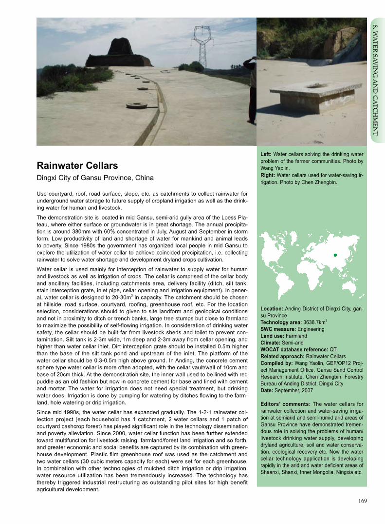
169
Rainwater CellarsDingxi City of Gansu Province, China
Use courtyard, roof, road surface, slope, etc. as catchments to collect rainwater for underground water storage to future supply of cropland irrigation as well as the drink-ing water for human and livestock.
The demonstration site is located in mid Gansu, semi-arid gully area of the Loess Pla-teau, where either surface or groundwater is in great shortage. The annual precipita-tion is around 380mm with 60% concentrated in July, August and September in storm form. Low productivity of land and shortage of water for mankind and animal leads to poverty. Since 1980s the government has organized local people in mid Gansu to explore the utilization of water cellar to achieve coincided precipitation, i.e. collecting rainwater to solve water shortage and development dryland crops cultivation.
Water cellar is used mainly for interception of rainwater to supply water for human and livestock as well as irrigation of crops. The cellar is comprised of the cellar body and ancillary facilities, including catchments area, delivery facility (ditch, silt tank, stain interception grate, inlet pipe, cellar opening and irrigation equipment). In gener-al, water cellar is designed to 20-30m3 in capacity. The catchment should be chosen at hillside, road surface, courtyard, roofing, greenhouse roof, etc. For the location selection, considerations should to given to site landform and geological conditions and not in proximity to ditch or trench banks, large tree stumps but close to farmland to maximize the possibility of self-flowing irrigation. In consideration of drinking water safety, the cellar should be built far from livestock sheds and toilet to prevent con-tamination. Silt tank is 2-3m wide, 1m deep and 2-3m away from cellar opening, and higher than water cellar inlet. Dirt interception grate should be installed 0.5m higher than the base of the silt tank pond and upstream of the inlet. The platform of the water cellar should be 0.3-0.5m high above ground. In Anding, the concrete cement sphere type water cellar is more often adopted, with the cellar vault/wall of 10cm and base of 20cm thick. At the demonstration site, the inner wall used to be lined with red puddle as an old fashion but now in concrete cement for base and lined with cement and mortar. The water for irrigation does not need special treatment, but drinking water does. Irrigation is done by pumping for watering by ditches flowing to the farm-land, hole watering or drip irrigation.
Since mid 1990s, the water cellar has expanded gradually. The 1-2-1 rainwater col-lection project (each household has 1 catchment, 2 water cellars and 1 patch of courtyard cashcrop forest) has played significant role in the technology dissemination and poverty alleviation. Since 2000, water cellar function has been further extended toward multifunction for livestock raising, farmland/forest land irrigation and so forth, and greater economic and social benefits are captured by its combination with green-house development. Plastic film greenhouse roof was used as the catchment and two water cellars (30 cubic meters capacity for each) were set for each greenhouse. In combination with other technologies of mulched ditch irrigation or drip irrigation, water resource utilization has been tremendously increased. The technology has thereby triggered industrial restructuring as outstanding pilot sites for high benefit agricultural development.
Left: Water cellars solving the drinking water problem of the farmer communities. Photo by Wang Yaolin. Right: Water cellars used for water-saving ir-rigation. Photo by Chen Zhengbin.
Location: Anding District of Dingxi City, gan-su ProvinceTechnology area: 3638.7km2
SWC measure: EngineeringLand use: FarmlandClimate: Semi-arid WOCAT database reference: QTRelated approach: Rainwater CellarsCompiled by: Wang Yaolin, GEF/OP12 Proj-ect Management Office, Gansu Sand Control Research Institute; Chen Zhengbin, Forestry Bureau of Anding District, Dingxi CityDate: September, 2007
Editors’ comments: The water cellars for rainwater collection and water-saving irriga-tion at semiarid and semi-humid arid areas of Gansu Province have demonstrated tremen-dous role in solving the problems of human/livestock drinking water supply, developing dryland agriculture, soil and water conserva-tion, ecological recovery etc. Now the water cellar technology application is developing rapidly in the arid and water deficient areas of Shaanxi, Shanxi, Inner Mongolia, Ningxia etc.
8. WA
TER SAVIN
G A
ND
CA
TCH
MEN
T

170
Growing season: 140 days in succession, from May to OctoberSoil fertility: lowSoil texture: thin (clay)Surface stoniness: none Topsoil organic matter: moderate (1%-3%) Soil drainage: moderateSoil erodibility: high
Land use rights: individualLand ownership: state or collectiveMarket orientation: mixed, for self use or for sellingLevel of technical knowledge required: moderate to tech-nical extensionists and land usersImportance of off-farm income: 10%-50% of total income
Classification
Land use problemsLow precipitation, deficient groundwater, arid and short of water supply; rainfall in form of storms to form runoff arousing serious soil and water erosion; low and unstable land productivity because of aridness and soil infertility.
Land use Climate Degradation SWC measure
Wheat,maize, Semi-arid Water erosion Mechanical and potato measure
Technical function/impact main: - intercept the runoff secondary: - promote the development of dryland agriculture - solve the drinking water problem for humans and livestock - improve the local villagers’ living standard - serve supplementary irrigation of the cropland
Environment
Natural Environment Average annual rainfall (mm) Altitude (m a.s.l.) Landform Slope (%)
very steep (>60)steep (30–60)hilly (16–30)rolling (8–16)moderate (5–8)gentle (2–5)flat (0–2)
>4000 >4000 3000–4000 3500–4000 2000–3000 3000–3500 1500–2000 2500–3000 1000–1500 2000–2500 750–1000 1500–2000 500–750 1000–1500 250–500 1000–500 <250 <500
Soil depth (cm)
0–20 20–50 50–80 80–120 >120
Human environment
Mixed land per household (hm2)
<1 1–2 2–5 5–15 15–50 50–100 100–500 500–1000 1000–10000 >10000
ridges
ridgeshill slopes
foot slopesvalley floors
mountain slopes
plains/plateaus

171
Technical drawing
Structure of the cylinder type water cel-lar (40m3).
Notes:1. specifications in cm2. dry unit weight of rammed lime earth for the cellar base no less than 1.65g/cm3
3. cellar top and base built with concrete cement of 150#
Establishment inputs and costs per hm2
Inputs Costs (US$) % met by land user
Labor 140 100%
Steel bar (20kg) 26.7 100%
Sand, gravel (7m3) 33.3 100%
Concrete cement (1ton) 40 0%
Bricks (200 pieces) 5.3 100%
Transportation 26.7 100%
TOTAL 272 85%
Establishment activities1. Identification of cellar location, by considering the geologi-cal condition such as easier water collection. 2. Construction of water cellar capping. Dig the earth into an arch shape pile, and conduct lining with concrete cement, steel bar, sand, gravel by reserving the cellar opening about 70-80cm in diameter. 3. Dig the earth downward from the cellar opening according to the designed depth and width. 4. Building the cellar body. Use concrete cement and sand for lining of thickness about 15cm. 5. Building of cellar base. Use cement, sand and steel bar for lining of the thickness about 20cm. 6. Antiseepage treatment. Use sanded cement grout at the ratio 1:2 for treatment of cellar inner wall and footwall. 7. Construction of the cellar platform. Build cellar platform with bricks, cement and sand. Cover the opening with a cellar cover.
Maintenance/recurrent activities 1. Clear the water channel prior to rainfall. Close the water inlets immediately once the cellar is full to avoid collapse due to water overburdening the seepage protection.2. Dredge regularly the sediments of the cellar. 3. Disinfect the stored rainwater if for drinking water of human or livestock.
Maintenance/recurrent inputs and costs per hm2 per year
Inputs Costs (US$) % met by land user
Labor 23.3 100%
Equipment
Materials
Other 2.67 100%
TOTAL 25.97 100%
Implementation activities, inputs and costs
Remarks: Labor calculated at the local prevailing price of 2007 of 35RMB Yuan per person day. Exchange rate: US$1=RMB 7.5 Yuan.
silt tankwater inlet pipe
Profile of a 40 cubic meters cement-shell water cellar
1010
045
060
2050
cast-in-situ concrete C15
cast-in-situ concrete C15
punning of original soil
cement sand plaster M10
320
8. WA
TER SAVIN
G A
ND
CA
TCH
MEN
T

172
Assessment
Acceptance/adoption- All farmer households accept the technology actively. - Most household adopted the technology through project support while other households invested by themselves for the construction. - Government takes the responsibility for extension, through convening meetings, demonstrations as well as incentive measures etc. - The incentive measure is in form of subsidy of construction materials.
Benefits/costs according to land user Benefits compared with costs Short-term Long-term
establishment negative positive
maintenance/recurrent positive positive
Impacts of the technology
Production and socio-economic benefits Production and socio-economic disadvantages
+ + + Solve the human and living stock drinking water problem – Short term economic burden
+ + + Improve crop production
+ + + Improve rainwater utilization rate
Socio-cultural benefits Socio-cultural disadvantages
+ + Add knowledge of soil and water conservation and agriculture None
+ + Improve capacity building of the communities
Ecological benefits Ecological disadvantages
+ + + Intercept runoff and conserve soil and water None
+ + + Improve moisture and nutrient condition of the soil
Off-site benefits Off-site disadvantages
+ + Reduce silt inflow of the downstream – Runoff decease of the downstream
Concluding statements
Strengthens and → how to sustain/improve
Intercept and retain runoff and reduce soil and water losses → Con-tinuous extension for wider coverage.
Supplementary irrigation to the cropland for higher production → Integrate with conservation farming for more extensive benefits.
Weaknesses and → how to overcome
High initial establishment cost → Seek more project support.
Key reference(s) Wang Lin. Water cellar Construction technology for rainwater collection and water-saving irrigation in the mountainous areas. Gansu water conservancy and hydro power technology, 2002, 38(4). Contact person(s)Wang Yaolin, GEF/OP12 Project Management Office, Gansu Sand Control Research Institute. Tel: 0931-8412816. Email: [email protected]

173
Rainwater CellarsDingxi City of Gansu Province, China
Government takes the lead and propelled by project, the rainwater collection for ir-rigation technology scales up by demonstration.
Dingxi County of Gansu Province is short of water resource. There is an old saying “It’s hard to exchange a cup of water for a cup of oil in Anding of Dingxi”. During drought years, drinking water became a crisis and people had to walk dozens of miles to get water. With no self-relief capacity the local people live a hard life. To resolve water shortage, the most realistic method is to tap into the potential of local precipitation.
Under the support of Gansu provincial government, researches on rainwater collec-tion were conducted during period from 1988 to 1992 and water cellar technology was proven technically and economically feasible with its functions in preventing ero-sion, developing arid cropland and ecosystem recovery.
In 1994, the government disseminated water cellar technology in the northwestern part of the county covering 14 townships and 4376 households. After completion, the drinking water supply problem was mitigated for 22,000 people and 8700 animals. In 1995, a severe drought hit Gansu and provincial government immediately initiated “1-2-1” rainwater Collection Project, under which the government supplied cement and the local people provided sand/stone and labor to build water cellars. Accord-ing to this project each household should build one water catchment with an area of100m2 made by concrete cement and two water cellars and one backyard cash-crop forest. By the end of 2000, total of 57800 households involved in the project to provide drinking water to 60,900 people and 333,900 heads of livestock. In addition, dryland farming has seen great development. Since 1996, water cellar technology has been diversified and evolved. The water collection fields has extended from roof and courtyard to road surface, ditch, hillside, land brink, etc and the application has been widened to scale livestock farming, spot watering and conservation irrigation of farmland based on the achievement of “1-2-1” rainwater collection project. Moreover, water cellar technology has been gradually combined with greenhouse production, tourism agriculture, etc to form a development model integrating rainwater conserva-tion irrigation, dryland farming and improved livelihood standard.
The dissemination approaches include trial operation, demonstration, training, household visit for publicity, media (TV), technical handouts, posters. The key or-ganizer of the extension is the water resources bureau of Anding District as well as the township government. They called villager meetings to determine the supportive policies for the farmers who were about to build the water cellars. The farmers hired technical workers to construct the water cellars. Farmers may be voluntary promot-ers of the technology by spreading the advantages of water cellars. The government provided each household with one ton of cement free of charge (about RMB300) with the remainder of other materials, labor and shipping cost covered by the farmers. The locals have realized the importance of the project so some have built water cel-lars at their own cost. In 2007, donations for water cellar construction reached And-ing and were allocated in kind (one ton cement) to the farmers through the resolution passed at village meeting on a case by case basis.
Left: rainwater catchment experiment. Photo by Wang Yaolin Right: rainwater cellar used for cropland ir-rigation. Photo by Wang Yaolin
Location: Anding District of Dingxi City, Gan-su ProvinceLand use: EngineeringClimate: Semi-arid WOCAT database reference: QARelated technology: Rainwater CellarsCompiled by: Wang Yaolin, GEF/OP12 Proj-ect Management Office, Gansu Sand Control Research Institute; Chen Zhengbin, Forestry Bureau of Anding District, Dingxi CityDate: September, 2007
Editors’ comments: rainwater cellar technol-ogy is extended by the government through project incentives and in forms of demonstra-tions, training etc. This technology is one ma-jor measure for the arid and water deficient areas to solve the problems of drinking water, soil and water losses, poverty and agricultural development. As a very suitable technology in the arid areas, it has been widely extended in the dry mountainous areas in northwestern China.
8. WA
TER SAVIN
G A
ND
CA
TCH
MEN
T

174
Problem, objectives and constraints
Problem- Lack of effective grass-roots organization.- Backward economy and lack funds.- Farmers in lack of the knowledge of water cellar establishment and management.- Short of drinking water for human and domestic animals.
Objectives- Establish a extension mechanism that promotes sustainable development and involves farmers participation.- Improve the farmers’ knowledge about rainwater utilization. - Strengthen farmer participation and their confidence in overcoming difficulties.- Solve drinking water problem.- Eliminate poverty.
Major Specification
Fund shortage Farmers cannot afford water cellar construction.
Knowledge/technol- Short of knowledge of rainwater high efficiency utilization ogy shortage and related agricultureal technology.
Treatment
Governmental financial assistance, social public assistance.
Demonstration and training.
Constraints addressed
Participation and decision making
Target groups
Decision maker Land user SWC expert
Decisions on choice of the technology: Land users and decision makers.Decisions on method of implementing the technology: Land users or village leaders decide to build water cellars. Approach designed by: National and local SWC experts.
Community involvement
Phase Involvement Activities
Initiation Active Meetings, household visits.
Planning Active Participate in the survey and site location arrangement.
Implementation Active Labor input for technological implementation.
Monitoring/evaluation Active Observation, collaboration with the survey of the technicians.
Research Active Participate in the surveys.
Approach costs met by
Government 15%
Local funds 85%
TOTAL 100%
Differences in participation of men and women: Strong labor is required, so undertaken mainly by male laborers.

175
Organogram
Most of the water cellar projects are financed by the projects of Ministry of Water Resourc-es, with a small amount by public donations.
Ministry of Water Resources
County Water ResourcesBureau
Land Users
District Civil Affairs Bureau
Township GovernmentProvincial Department of Water Resources
Township Government
City Water Resource Bureau
Land Users
Extension and promotion
Training: The training is conducted in the forms of meetings, lectures, publicity brochures, site demonstrations. The contents are: water cellar building and management, irrigation etc. The training effect to farmers is satisfactory.
Extension: Extension work is undertaken by county water resources bureau and the agricultural technical extension station, and in the forms of meetings, publicity into households, site explanations etc.
Research: The research is conducted by provincial level researchers on the ecological, economic, social benefits of the water cel-lars, mainly.
Importance of land use rights: The land use right belongs to land users, and land use right does not affect technology implementation.
IncentivesLabour: Labor force is not paid.
Inputs: Concrete cement supplied free of charge by project or government, and all other materials and related traffic expenses cov-ered by land users.
Credit: Credits are sometimes used, with interest rate similar with that of commercial loan.
Support of local institutions: The technology application strengthened the capacity building of the local water resources depart-ments. Application of the technology helped other projects related to water conservancy and poverty reduction.
Long-term impact of incentives: The long-term impact of incentive is positive.
8. WA
TER SAVIN
G A
ND
CA
TCH
MEN
T

176
Monitoring and evaluation
Methods and indicators
Site survey on water storage.
Site measure of irrigated area.
Interview visit, improvement of farmers’ knowledge and technology.
Crop production, income, by site visits.
Survey and calculate the number of villagers that adopt the technology.
Survey the number of households that adopt the technology.
Township government conducts survey annually about water cellar use conditions and report to the higher level.
Monitored aspects
Bio-physical
Technical
Socio-cultural
Economic/production
Area treated
No. of land users involved
Management of approach
Impacts of the approach
Changes as result of monitoring and evaluation: The technology itself has not evolved from sole water cellar development to an assembled technology with others. The financial resources o support water cellars have been changed from sole government to social funds, moreover, the farmers would actively asks for building water cellars.
Improved soil and water management: The technology intercepts runoffs, solves deficiency of water resources, and raises land productivity.
Adoption of the approach by other projects/land users: It has been adopted extensively by neighboring provinces. Chinese Women’s Federation has initiated the public welfare program named “Mother’s Water Cellar” in northern China.
Sustainability: Insufficient project financial aid will affect the technology application.
Concluding statements
Strengthens and → how to sustain/improve
Solve the problems of aridness and drinking water for human and livestock → Continued project support.
Strong extension mechanism → Further strengthen the role of tech-nical extension organizations.
Improve farmer’s life → Develop dryland agriculture industry.
Weaknesses and → how to overcome
High investment for technology adoption → Use of micro-credits, optimized use of farming technology for high benefit agriculture.
Weak monitoring and evaluation → Establish participatory monitoring and evaluation mechanism.
Key reference(s) Shang Xinming et al. Rainwater collection and utilization and the rural economic development in central Gansu province. Arid Area Agricultural Studies, 1999, 17(2).
Contact person(s)Wang Yaolin, GEF/OP12 Project Management Office, Gansu Sand Control Research Institute

177
Artificial Inoculation of Cistanche deserticola to Haloxylon ammodendronAlashan League of Inner Mongolia, China
Inoculation of Cistanche deserticola to the roots of Haloxylon ammodendron to culti-vate Cistanche deserticola product.
Alashan League is located in the arid highland Gobi desert of western China, with 850-1500m in elevation, 7.4-8.8℃ annual mean temperature, 40-200mm annual precipita-tion, 2600-3800mm of annual evaporation; soil types are of sierozems, grey-brown desert soil and aeolian soil. Desert plants Reaumuria trigyna Maxim, Zygophyllum xanthoxylum, Sorbaria sorbifolia, Artemisia, Haloxylon ammodendron, Calligonum, etc. sparsely dominate the vegetation. The local economy largely relies on traditional livestock grazing with low returns, and the local people live a hard life. Overgrazing places a big pressure on ecosystems. Therefore, replacing the low-return singular eco-nomic production pattern with multiple sustainable development patterns is a priority.
Cistanche deserticola is a parasitical plant to haloxylon ammodendron roots and a valuable Chinese medicinal herb. With the development and utilization of Cistanche deserticola health keeping products, the supply falls behind the ever-increasing market demand. Cistanche deserticola grows naturally in disperse manner and harvesting the wild plant is hard and will cause soil and water losses. Artificial plantation not only can develop Cistanche deserticola business to meet the demand for herb market, but also promote ecological balance by rejuvenating Haloxylon ammodendron stands.
Focal points of the technology: (1) soak Grade I or II Cistanche deserticola seeds in 500ppm ABT 3 rooting powder for 30min and use nutrition induction method for inocu-lation; (2) carry out inoculation in April and May. Dig a hole of the size 60cm in length, 30cm in width and 50cm in depth about 50-60cm away from the Haloxylon ammoden-dron trunk, and apply 1kg fermented humus manure and 10-15kg water for each hole. Identify healthy capillary roots and place 5-10 Cistanche deserticola seeds in its prox-imity and backfill the soil; and (3) harvest Cistanche deserticola in three years by using non-metal tools for excavation. In digging operation, keep the inoculation parasitic plate intact and replace it to roots in a slightly deeper location and then cover with soil.
The technology resolved the basic technical issues in the inoculation especially by using innovative nutrient induction inoculation method for increased operational suc-cess. Alashan is a suitable region for growth of Haloxylon ammodendron which has a wide natural distribution. There are also planted Haloxylon ammodendron and areas suitable for more plantations, making the region good for Haloxylon ammodendron and Cistanche deserticola development. The technology dissemination has high im-portance to increasing the technological level of key forestry programs such as the conversion of cultivated land conversion forest, restructuring local industrial of agricul-ture and animal husbandry, and promoting local economic development, and resource development and management.
Left: Hole-digging at the rooting of Haloxylon ammodendron for inoculation of Cistanche deserticola. Photo by Tian Yongzhen Right: Cistanche deserticola growth from the root of Haloxylon ammodendron. Photo by Tian Yongzhen
Location: Alashan league, Inner Mongolia Technology area: 1500km2
SWC measure: Agronomy /vegetationLand use: ForestClimate: Arid WOCAT database reference: QTRelated approach: Cistanche deserticola In-oculation Extension Supported by Research Compiled by: Tian Yongzhen, Alashan LeagueForestry Research Institute, Inner Mongolia; Tianlü, Inner Mongolia Forestry Monitering and Design Academy Date: August, 2007
Editors’ comments: The technology of Cistanche deserticola inoculation in arid desert area has been a successful model. It is an advanced, mature and easily operable technology with leading technological level in China. With its features of being simple and labor saving, it is suitable for large-scale ap-plication. Dissemination of this technology will have high significance for the well-being of local farmers, herdsmen and forestry staff as well as the ecological protection.
9. SAN
D IN
DU
STRY
178
very steep (>60)steep (30–60)hilly (16–30)rolling (8–16)moderate (5–8)gentle (2–5)flat (0–2)
Growing season: 180 days in succession, from April to September Soil fertility: very low Soil texture: coarse (sandy) Surface stoniness: moderate Topsoil organic matter: moderate(1%-3%)Soil drainage: moderateSoil erodibility: high
>4000 >4000 3000–4000 3500–4000 2000–3000 3000–3500 1500–2000 2500–3000 1000–1500 2000–2500 750–1000 1500–2000 500–750 1000–1500 250–500 1000–500 <250 <500
Soil depth (cm)
0–20 20–50 50–80 80–120 >120
Classification
Land use problemsLow vegetation cover, severe wind erosion, barren soil, aridness, fragile ecological condition.
Land use Climate Degradation SWC measure
Arid Wind erosion Biological measure Technical function/impact main: - promote industrial restructuring and desert industry development - contribute to environmental protection by restoring vegetation in desert areas
Environment
Natural Environment
Average annual rainfall (mm) Altitude (m a.s.l.) Landform Slope (%)
secondary: - increase farmer’s income
Land use rights: collectiveLand ownership: state Market orientation: mixedLevel of technical knowledge required: moderate to technical extensionists and low to the land userImportance of off-farm income: less than 10% of the total income
Human environment
Mixed land per household (hm2)
<1 1–2 2–5 5–15 15–50 50–100 100–500 500–1000 1000–10000 >10000
ridges
ridgeshill slopes
foot slopesvalley floors
mountain slopes
plains/plateaus
Forest land

179
Establishment inputs and costs per hm2
Inputs Costs (US$) % met by land user
Labor 54.9 100%
Equipment
- tractor, water trasnport vehicles 18.3 0%
Materials
- cistanche deserticola seeds, 18.3 0% culture solution etc.
Agricultural
- pesticide, fertilizer 18.3 0%
TOTAL 109.8 50%
Establishment activities1. Use Grade I, II seeds of Cistanche deserticola, and soak in 500mg/L ABT(3)rooting power for 30 minutes. Nutrient induci-ton incoculaiton method is adopted. 2. The inoculation is conducted 50-60 cm away from the truck of Haloxylon ammodendron, and at 40-60 cm depth, from April to May.
Establishemnt time: 3 years.
Remarks: annual maintainence cost at US$1463.4 (for 400hm2.); exchange rate US$1=RMB8.2yuan.
Maintenance/recurrent activities 1. Specialized staff for maintainance tending against livestock browsing and human damage.2. Prevention and conrol of pests and diseases.
Maintenance/recurrent inputs and costs per hm2 per year
Inputs Costs (US$) % met by land user
Labor 3.7 100%
Equipment
Moter vihile 1.8 100%
Materials
- fuel, maintainence etc 1.2 100%
Agricultural 6.7 100%
TOTAL 13.4 100%
Technical drawing
Dig a hole of 20-30cm in diameter, 40-60cm in depth, and 50-60 cm away from the Cistanche deserticola truck for inoculation. The inoculation time is from April to May. For each Cistanche deserticola plant , one or two holes can be made for inoculai-otn. For each inoculation hole, apply 1 kg fully fermented organic fertilizer, and 10-15 kg water.
Drawing by Li Minyu
40-60cm
50-60cm
Cistanche deserticola inoculated to Haloxylon ammodendron
Implementation activities, inputs and costs
9. SAN
D IN
DU
STRY

180
- -
Assessment
Acceptance/adoption
Benefits/costs according to land user Benefits compared with costs Short-term Long-term
establishment neutral very positive
maintenance/recurrent very positive very positive
Impacts of the technology
Production and socio-economic benefits Production and socio-economic disadvantages
High benefit/cost ratio, short income generation cycle (harvest starts in 3 yrs after inoculation), high profitability
Contribute to the poverty alleviation of the locality
Socio-cultural benefits Socio-cultural disadvantages
+ + Promote institutional capability building None
+ + Extend scientific knowledge and improve local people’s
technological level
Ecological benefits Ecological disadvantages
+ + Effectively promote the rejuvenation of the natural Haloxylon The inoculation and harvest digging lead to ammodendron stands and expansion of forest plantation some vegetation loss and soil and water erosion
+ + Combat sandification for improved regional ecological Result in some nutrient loss and therefore
condition low growth to the parental plants of Haloxylon ammodendron Off-site benefits Off-site disadvantages
+ Promote the development of the neighboring and related None desert industries
Concluding statements
Key reference(s) [1] Alashan Forestry Research Institute of Inner Mongolia. Key and supplemental technology researches on Cistanche deserticola
inoculation. Collections of Inner Mongolia Forestry Research Accomplishments in Science and Technology (2001-2005). 2006.64-66.
[2] Alashan Forestry Research Institute of Inner Mongolia. Inoculation technology of Cistanche deserticola to Haloxylon ammod-endron (Internal Information), 2007.
Contact person(s)Tianlü, Inner Mongolia Forestry Survey and Planning Institute. Tel: 86-471-5953487. Email: [email protected]
Strengthens and → how to sustain/improve
Simple inoculation operation for easy grasp of the technology→ Gradually develop mechanized operation.
Saved use of seeds and high success rate of inoculation→ Im-prove the genetic quality through genetic improvement efforts.
Weaknesses and → how to overcome
Pit digging leading to tosoil and water erosion→ Timely backfilling of the soil and spraying of water on earth surface.
Nutrient loss and therefore low growth to the parental plants of Haloxylon ammodendron → Adequate nutrient supplementation.
During the project implementation, the contracting arrangement is adopted by linking the contractor’s income with the project opera-tional benefit, which significantly motivated the enthusiasm of the land managers.
+ + +
+ +
+ + Contribute to industrial restructuring of the local agri-culture and animal husbandry
None
-
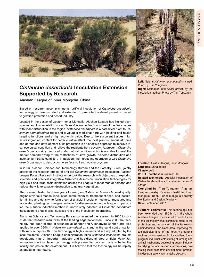
181
Cistanche deserticola Inoculation Extension Supported by Research Alashan League of Inner Mongolia, China
Based on research accomplishments, artificial inoculation of Cistanche deserticola technology is demonstrated and extended to promote the development of desert vegetation protection and desert industry.
Located in the desert of western Inner Mongolia, Alashan League has limited plant species and low vegetation cover. Haloxylon ammodendron is one of the few species with wider distribution in the region. Cistanche deserticola is a parasitical plant to Ha-loxylon ammodendron roots and a valuable medicinal herb with healing and health keeping functions and a high economic value. Due to the succulent tissues, high active ingredient content for better curative effect, the local plant is famous at home and abroad and development of its production is an effective approach to improve lo-cal ecological condition and relieve the residents from poverty. At present, Cistanche deserticola is mainly produced under natural condition which is not able to meet the market demand owing to the restrictions of slow growth, disperse distribution and inconvenient traffic condition. In addition, the harvesting operation of wild Cistanche deserticola leads to destruction to surface soil and local ecosystem.
In 2003, Alashan Science and Technology Bureau and the Forestry Bureau jointly approved the research project of artificial Cistanche deserticola inoculation. Alashan League Forest Research Institute undertook the research with objectives of exploring scientific and practical integrative Cistanche deserticola inoculation technologies for high yield and large-scale plantation across the League to meet market demand and reduce the wild excavation destruction to natural vegetation.
The research lasted for three years focusing on Cistanche deserticola seed quality, origins of various stands, inoculation depth, chemical treatment of seed, and inocula-tion timing and density, to form a set of artificial inoculation technical measures and modulated planting technologies suitable for dissemination in the league. In particu-lar, the nutrition induction method is innovatively adopted in Cistanche deserticola inoculation to enable great success rate of the inoculation operations.
Alanshan Science and Technology Bureau commanded the research in 2005 to con-clude that research result was at the leading edge nationwide. Since 2006 the tech-nology has been piloted in Alashanzuo Banner and Alashanyou Banner, and also applied to over 350hm2 Haloxylon ammodendron stand in the sand control station with satisfactory results. The technology is highly viewed and actively adopted by the local residents. Alashan League administration takes Cistanche deserticola proucts development as an important industry and has disseminated artificial Haloxylon ammodendron inoculation technology with preferential policies made to better the locality and protect the environment. It is believed that the technology will be rapidly extended in near future.
Left: Natural Haloxylon ammodendron.stnad. Photo by Tian Yongzhen Right: Cistanche deserticola growth by the inoculation method. Photo by Tian Yongzhen
Location: Alashan league, Inner Mongolia Land use: Shrub forestClimate: Arid WOCAT database reference: QARelated technology: Artificial Inoculation of Cistanche deserticola to Haloxylon ammod-endronCompiled by: Tian Yongzhen, Alashan LeagueForestry Research Institute, Inner Mongolia; Tianlü, Inner Mongolia Forestry Monitering and Design Academy Date: September, 2007
0Editors’ comments: This technology has been extended over 350 hm2. in the whole Alashan League. Increase of extended area of the technology shall contribute more to the protection and expansion of the Haloxylon ammodendron shrubland area, improving the technological level of the forestry programs such as the conversion of cultivated land forest program, industrial restructuring of farming and animal husbandry, developing desert industry by relying on local resource advantages, pro-moting local economic development, promot-ing desert area environmental protection.
9. SAN
D IN
DU
STRY

182
Problem, objectives and constraints
Problem- Local residents lack inoculation knowledge of Cistanche deserticola. - Communities lack effective organizational system for technological extension.
Objectives- For an extension that integrates research and production. - Protect natural vegetation in desert area and improve ecological condition. - Raise farmer and herdsman’s capability in inoculation of cistanche deserticola. - Increase the comprehensive processing capability of cistanche deserticola to promote the development of desert industry.
Constraints addressed
Major Specification Treatment
Technical Local participants of the project are mainly herdsman who are Reinforce promotion and encouragement; carry out training inhabited to traditional grazing life and slow in accepting of farmers and herdsman, and adopt market measures newly developed industries. for guidance.
Minor Specification Treatment
Social
Participation and decision making
Target groups
Planner Decision maker Land user
Decisions on choice of the technology: Land users. Decisions on method of implementing the technology: Jointly by You Banner Forestry Bureau of Alashan League and land users. Approach designed by: Alashan League Forestry Research Institute.
Community involvement
Phase Phase Activity
Initiation Passive Been informed of the project and attend the related mobilization meeting.
Planning Passive Participate in the planning and opinions soliciting.
Implementation Active Participate in the operations of inoculation and maintenance tending etc.
Monitoring/evaluation Interactive Soil sampling, survey of the Cistanche deserticola production.
Research Not involved
Differences in participation of men and women: No difference.
Approach costs met by
Government 50%
Land users 50%
TOTAL 100%
Scientifically select the demonstration sites; establish Ha-loxylon ammodendron stands at sites with better traffic conditions.
Most of the natural Haloxylon ammodendron stands grow in remote areas with inconvenient traffic conditions, restricting the artificial inoculation and harvests.

183
Extension and promotion
Training: The training topic is the artificial inoculation technology of Cistanche deserticola; 120 person times of forest farm workers, farmers and herdsman were trained; and the training is in forms of lectures in combination with on-site supervision.
Extension: The Forestry Bureau of the League is responsible for the organization of the extension with technical support from the league’s Forestry Research Institute. The extension is conducted in forms of lectures, and site demonstrations, etc. The training is done firstly to the sand control station staff and some herdsmen. The trainees have now grasped this technology. Now the extension area of the inoculation has reached to 330 hm2.
Research: The research is mainly conducted by the league’s Forestry Research Institute, with the sand control station staff providing some observation data.
Importance of land use rights: The project is implemented on the land user’s own land, so the land tenure does not affect the tech-nological extension.
Incentive mechanism
Labour: Labour is not paid, the government offer technical service free of charge.
Inputs: Cistanche deserticola seed is supplied by governmental seed stations while the costs of tractors and water transport vehicles etc. are covered by the contractors.
Credit: Micro credit of RMB1000-2000 Yuan per household with subsidized interest is available.
Support of local institutions: The application of technology improved the recognition, identification, and the influence of the local forestry research and extension organizations, and helped the above organizations accessing more project fund.
Long-term impact of incentives: Incentives (by project or subsidy) have obvious effect on the technological extension and Cistanche deserticola business development. With further technical extension and increased benefits, the land users shall still adopt the technology without incentives.
Organogram Project’s research is financed and approved by the league’s Science and Technology Bu-reau and implemented by Forestry and Sand Control Research Institure;Project extension is organized by the league’s Forestry Bureau and implemented by banner forestry depart-ments and the town forestry stations.
Alashan Science and Technology Bureau Alashan Forestry Bureau
Alashan Forestry and Sand Control Research Institure
Farmers, Herdsmen, and Forest Farm Workers
Ejina Banner Forestry Bureau
Bulai Sand ControlStation of Ayou Banner
Jilantai Town of AyouBanner
9. SAN
D IN
DU
STRY

184
Monitoring and evaluation
Monitored aspects Methods and indicatorsBio-physical Measure the annual growth conditions of Haloxylon ammodendron include tree height, crown size.
Technical Inventory the inoculation success rate, and annual productivity of Cistanche deserticola
Socio-cultural questionnaire investigation on the attitude and acceptance of farmers and herdsmen toward the technology.
Economic/production Inventory and calculation of Cistanche deserticola production and the comparative economic benefits.
Area treated Survey the implementation area and changes of land use types.
No. of land users involved Sample survey the number of land users concerned and the structural change.
Management of approach The Science and Technology Bureau and the Forestry Bureau of Alashan League monitor the view to the tech- nology and the extension area.
Impacts of the approach
Changes as result of monitoring and evaluation: The extension which is not in preliminary stage is organized by forestry man-agement department with technical guidance of the forestry technical institutions.
Improved soil and water management: The technology helps using the groundwater resource more efficiently. Through the plant-ing of Haloxylon ammodendron, drift sand is fixed and soil quality is improved.
Adoption of the approach by other projects/land users: The farmers and herdsmen involved in the project adopt this technology.
Sustainability: Because of the satisfactory ecological and economic benefits, the technology will be adopted in long-term.
Concluding statements
Strengthens and → how to sustain/improve*
Research and extension are integrated → Further reform the cur-rent extension mechanism.
Integration with industrial development → Enhance processing and enterprise cultivation for sustainable development.
Weaknesses and → how to overcome
Low community participation level → Introduce community participation tools.
Key reference(s) [1] Alashan Forestry Research Institute of Inner Mongolia. Key and supplemental technology researches on Cistanche deserticola
inoculation. Collections of Inner Mongolia Forestry Research Accomplishments in Science and Technology (2001-2005). 2006.64-66.
[2] Alashan Forestry Research Institute of Inner Mongolia. Inoculation technology of Cistanche deserticola to Haloxylon ammod-endron (Internal Information), 2007.
Contact person(s) Tianlü, Inner Mongolia Forestry Survey and Planning. Tel: 86-471-5953487. Email: [email protected]

185
Integrated Development of Salix Psammophila Ejin Horo Banner of Inner Mongolia, China
Plant Salix psammophila for wind breaking and sand fixation and meanwhile for the coppice harvest every three years for processing of wood based panel or for use as animal feedstock and fuel.
The project site is in the outskirt of Mu Us Desert and Kubuqi Desert, Erdos, Inner Mongolia, where fixed and semi-fixed sand dunes prevail. It is in semi-arid climate of temperate zone, with 350mm annual precipitation. There is relatively rich ground wa-ter. The soil types include aeolian soil, saline soil, and meadow soil, etc. Vegetation includes Agriophyllum squarrosum, Artemisia sphaerocephala Krasch, Artemisia Or-dosica, Caragana, and Salix psammophila, etc.
Soil sandification has taken place in different degrees owing to human and natural factors to result in wind erosion, sand invasion on grassland/farmland, and worsened production and living conditions.
The project is aimed at developing Salix psammophila plantations for artificial board in-dustry with active participation of farmers in planting to push forward the local ecologi-cal construction and economic development.
Main technical procedures: (1) Planting of cuttings – select sites inter–dune lowland and plain sandy lands, etc., for planting ofcuttings, in two-row belts at 1m row spacing and 0.5m plant spacing. Cuttings of 50cm long are planted in spring or autumn. The planting is done immediately after the pit is ready (care should be taken not setting the cutting upside down). Use the wet sand from the second pit to fill the first one, and so forth, and compress the soil firmly in layers, use the wet sand from the third pit to fill the second hole and tread soil firm, repeat above steps. The cuttage should be put in soil to level with the ground surface, or 3-5cm underground if the sand moisture is insufficient or in autumn. (2) Tending management – water the planted cuttings four times in the first year if possible, and three times a year thereafter. Weeding and soil loosening should be done for three times a year with adequate water and fertilizer sup-ply. Supplementary planting should be conducted on sites with survival rate less than 90%, or sites with high survival but uneven growth or deaths in blocks. (3) Coppicing – cut the growth from the trunk in the fourth year, and thereafter, coppicing harvest should be made every three years. The operation should be done in every other belt to maintain adequate vegetation cover.
The project has produced multiple benefits. For the past decade, Salix psammophila planting area has increased by 10% per annum and the area has reached 600000ha at present. Most of the forests were raised by farmers and enterprises on their own wishes, bring remarkable economic benefit to local farmers. Each year the factories spend RMB33 million yuan to purchase Salix psammophila from farmers and the lat-ter receive RMB470 yuan for for each hectare of trees sold harvested. The project has benefited 300000 farmers and about 10000 households out of poverty. In addition, sur-plus labors were employed on the project.
Left: Salix psammophila plantation as indus-trial raw material forest. Photo by Ma JianRight: Salix psammophila plantation following the coppice harvest. Photo by Ma Jian
Location: Ejin Horo Banner, Inner Mongolia Technology area: 600km2
SWC measure: VegetationLand use: Grazing and otherClimate: Semi-arid WOCAT database reference: QTRelated approach: Salix Psammophila En-terprise Development to Facilitate Ecological Construction Compiled by: Tian Lü, Inner Mongolia For-estry Survey and Design Institute Date: August, 2007
Editors’ comments: Now this technology has been extended allsidedly in Erdos city of Inner Mongolia with good enterprise revenues and household income addition. This economy benefit and ecological benefit combined tech-nology can be extended in the wide sandy area suitable for Salix psammophila growth.
9. SAN
D IN
DU
STRY

186
Growing season: 150 days in succession Soil fertility: low Soil texture: coarse sandySurface stoniness: plentiful loose rock and gravel Topsoil organic matter: 0.1%-2.96%Soil drainage: moderateSoil erodibility: moderate
>4000 >4000 3000–4000 3500–4000 2000–3000 3000–3500 1500–2000 2500–3000 1000–1500 2000–2500 750–1000 1500–2000 500–750 1000–1500 250–500 1000–500 <250 <500
Soil depth (cm)
0–20 20–50 50–80 80–120 >120
Land use rights: collectives or individuals Land ownership: the state or collectives Market orientation: mixedLevel of technical knowledge required: moderate to technical extensionists and land usersImportance of off-farm income: 10%-50% of total income
Human environment
Mixed land per household (hm2)
<1 1–2 2–5 5–15 15–50 50–100 100–500 500–1000 1000–10000 >10000
Forest Biologicalmeasure
Classification
Land use problemsLow ground vegetation cover and severe wind erosion; barren soil and low land productivity; some plantations with low benefits
Land use Climate Degradation SWC measure
Semi-arid Wind erosion Technical function/impact main: - increased vegetation cover to reduce wind erosion - increased income to farmers and herdsmen - inccreased sales of the enterprise
Environment
Natural Environment
Average annual rainfall (mm) Altitude (m a.s.l.) Landform Slope (%)
ridges
ridgeshill slopes
foo tslopesvalley floors
mountain slopes
plains/plateaus
secondary: - improve soil fertility - creat employment opportunities
very steep (>60)steep (30–60)hilly (16–30)rolling (8–16)moderate (5–8)gentle (2–5)flat (0–2)

187
1m
0.5m
5m
Remarks:labor price at US$3.7/person day, exchange rate at the time of establishment: US$1=RMB8.2yuan.
Establishment inputs and costs per hm2
Inputs Costs (US$) % met by land user
Labor 54.9 100%
Equipment
- tractor, water transport vehicles 18.3 100%
Materials
- seedlings 36.6 100%
Agricultural
TOTAL 109.8 100%
Establishment activities1. Salix psammophila vegetative reproduction. Cuttings of 50cm length are planted in two-row belts on lowland between dunes, plain sandy lands, etc., at 1m row spacing and 0.5m plant spacing. Planting time in spring or autumn. The planting depth is to the cutting length. In case of low soil moisture or planting in autumn, top end of the cuttings is to be at 3-5 cm below the gound surface.2. Tending. Irrigate the planting pit four times in the first year when possible and three times a year thereafter to saturation.3. Coppice harvest. Cut the growth from the plant stock in the fourth year, and then once every three years. The coppice harvest should be done to every alternate belts to maintain adequate vegetation cover.
Maintenance/recurrent activities 1. Coppice harvest starts in the fourth year after planting, to be made from beginning of winter season to beginning of soil thawing of the following year.2. Pest and disease prevention and control.3. Assign special manpower for protection against the live-stock browsing and human.
Maintenance/recurrent inputs and costs per hm2 per year
Inputs Costs (US$) % met by land user
Labor 73.2 100%
Equipment
- tractor, coppice harvester 36.6 100%
Materials
- seedlings, pesticide 9.1 100%
Agricultural
TOTAL 118.9 100%
Technical drawing
Cuttings of 50cm length are planted in belts on inter-dune lowland, plain sandy lands etc.
Select sites of inter-dune lowlands, plain sandy lands, etc., for planting of cuttings, in two-row belts at 1m row spacing and 0.5m plant spac-ing. Cutting length 50 cm. First cop-pice harvest in the fourth year after planting, and thereafter once every three years to every alternate belt. The harvest biomass is sent to wood based panel factory for processing procures of crushing, sieving, gluing, and extrusion forming for finished products.
Drawing by Li Minyu
Salix psammophila plantation lavout
Implementation activities, inputs and costs
9. SAN
D IN
DU
STRY

188
- -
Assessment
Acceptance/adoption- With the growth of economic benefit of planting Salix psammophila year by year, farmers and herdsmen become more enthusiastic in developing
plantations. Most householders hold positive attitude to the technology.- Drops of sales of the enterprises and lower income can turn the attitude of farmers and herdsmen to negative toward the technology.
Benefits/costs according to land user Benefits compared with costs Short-term Long-term
establishment positive very positive
maintenance/recurrent positive very positive
Impacts of the technology
Production and socio-economic benefits Production and socio-economic disadvantages
+ + + Promotion of local ecological construciton None
+ + + Added revenue to the local government
+ Positiverole in local agriculture and animal husbandry industrial restructuring
Socio-cultural benefits Socio-cultural disadvantages
+ + + Improved theknowledge level and capability of local None farmers and herdsmen in ecological protection
Ecological benefits Ecological disadvantages
+ + + Fixing of large areas of sand dunes Slight reduction of ecological benefit and environ- mental pollution
+ + + Increased forest cover
+ + Inproved ecologicla condition
Off-site benefits Off-site disadvantages
+ + Farmers and herdsmen in neighboring area are motivated None for Salix psammophila planting
Concluding statements
Key reference(s) [1] Liu Shu. Brief study of sand industry. Beijing: China Environmental Science Press, 2001.[2] Yang Junping. The role of forestry science and technology in ecological construction. Hohhot: Inner Mongolia Autonomous Re-
gion. Inner Mongolia University Press, 2004: 253-258.
Contact person(s)Tian Lü, Inner Mongolia Forestry Survey and Design Institute. Tel: 86-471-5953487. Email: [email protected]
Strengthens and → how to sustain/improve
Fixing of dunes and improvement of environment → To fur-ther expand the plantation.
Promotion of economic developemnt→ To further enhance the development.
Weaknesses and → how to overcome
Wastes from the processing → To set up sewage processing system, and use resi-dues for edible fugus or organic fertilizer development for circular economy.

189
Salix Psammophila Enterprise Development to Facilitate Ecological Construction Ejin Horo Banner of Inner Mongolia ,China
Increase market demand via enterprising to push Salix psammophila plantation and realize win-win of ecological and economic development.
Salix psammophila is a common shrub growing in desert and distributed in Mu Us Desert and Kubuqi Desert in Erdos Municipal, Inner Mongolia. It features high sur-vival rate, fast growth and tolerance to desert environment. Coppicing (cut off the aboveground shoots at ground level) for every 2-3 years is required to promote flour-ishing growth and avoid plant death. The plant can be used for weaving crafts and as forages and fuel, so it is an important production and living material. In recent years it has been used for producing particle board, medium and high density board, fiber board, etc., with remarkable economic benefits.
Local farmers traditionally used Salix psammophila for fuel, and plantation of Salix psammophila hardly led to income, making the enthusiasm and progress of Salix psammophila plantation very low and resulting in withering of plantations due to lack of timely coppicing. In 1989, the first particle board factory of 5000 cubic meters/a production capacity was set up in Erdos using Salix psammophila as raw materail, and 8500t of produce was consumed by the factory the same year. Thereafter, Salix psammophila enterprise was swiftly developed into a local industry, and in 2006, there were eight factories producing particle board with a total capacity of 200,000m3 and requiring nearly 330,000t/a of Salix psammophila for producing RMB200 million yuan of the product value and RMB35 million yuan of profit. Farmers’ enthusiasm was reactivated in wake of the large demand for the raw material, and many facto-ries established their own Salix psammophila plantation bases. Such joint efforts have enabled Salix psammophila plantation area to grow at a rate of 10% per annum in the past decade to reach a total area of 600,000hm2 today.
The Salix psammophila utilization project in Erdos has been carried out with govern-mental support, market orientation, and economic stimulation. Government finance with discounted or low interest loan enterprises helped with building or expanding the factories. The forestry administration was in charge of uniform planning of the raw material production base with the planting funded by the farmers and forest farm owners. The forest administration also provided the production data to the enterpris-es who then determine market price according to the production and planting cost and organize the board production.
As proven in years of practice, Salix psammophila enterprise development for board production triggered the ecological construction. The technology application by proj-ect contributes to side by side ecological and economic improvement, increased par-ticipation of farmers in expanding plantation, and additional income.
Left: Coppice harvest of Salix psammophila. Right: Wood composite panel made of Salix psammophila.Photo by Ma Jian
Location: Ejin Horo Banner, Inner Mongolia Land use: ForestClimate: Semi-arid WOCAT database reference: QARelated technology: Integrated Develop-ment of Salix psammophila Compiled by: Tian Lü, Inner Mongolia For-estry Survey and Design Institute Date: August, 2007
Editors’ comments: This project is imple-mented with governmental support, on market operation basis, and as an economic growth stimulator for local development. It has been proved a feasible technology contributive to enterprise revenues, household income increase. With the economic and ecological benefits of the technology, it is in vigorously extension in Erdos city and the prospect is promising.
9. SAN
D IN
DU
STRY

190
Problem, objectives and constraints
Problem- Lack of macro guidance for coppice harvest, leading to excessive or insufficient production. - Lack of other plants in salix psammophila stands, so the ecological effect is low.- Farmers and herdsmen lack the knowledge and technology on salix psammophila planting, ecological protection, and process-
ing, etc.
Objectives- Form effective investment and extension mechanism. - Raise community’s awareness in ecological protection. - Improve the coordination efficiency between communities and enterprises.
Constraints addressed
Major Specification Treatment
Technical Lack of effective machinery for coppice harvest. Innovate the coppice harvest machinery.
Social Low knowledge level and poor skills of the labourers. Expertise formation by training and incentives.
Minor Specification Treatment
Low developemnt strength
Participation and decision making
Target groups
Decison maker Land user Planner
Decisions on choice of the technology: Farmers and herdsmen. Decisions on method of implementing the technology: Farmers and herdsmen. Approach designed by: Forest experts of the banner.
Community involvement
Phase Phase Activity
Initiation Passive Provide usable land and sign contract on Salix psammophila plantation.
Planning Passive Participate in the planning process, arrange the planting sites.
Implementation Positive Salix psammophila planting, tending, coppice harvest, and transportation.
Monitoring/evaluation No participation
Research No participation
Differences in participation of men and women: The difference in the role of men and women is not significant for the implemen-tation.
Approach costs met by
Households 100%
TOTAL 100%
Sole product of wood based panel, no development yet for paper carton, edible fungus etc.
Policy guidance and financial support.

191
Extension and promotion
Training: Banner and town forestry station technicians offered training of Salix psammophila planting and coppicing to farmers and herdsmen in the forms of distributing handouts and site demonstration, with satisfactory results.
Extension: Government supports the growth of processing enterprises, and recommend to villagers for Salix psammophila planting, while the town forestry station technical staff take the responsibility on technological extension.
Research: Enterprises increased their economic efficiency through the technical innovation in raising raw material utilization, Erdos City Forestry Research Institute conducted studies on optimal planting density of Salix psammophila and growth for improved pro-duction, which have promoted the development of the project.
Importance of land use rights: The sandy soil wasteland ownership rights and use rights belong to state or collectives. The govern-ment offers preferential policy for enterprises to establish raw material production bases. The role of land rights is positive. Farmers and herdsmen who develop the plantations on their own land are not affected by the land tenure issues.
Incentive
Labour: Farmers and herdsmen resolve labor input by themselves while the enterprises that operate the raw material forest bases either employ labor or contract the production to individuals.
Inputs: For those land units incorporated into national priority projects, seedlings are provided free of charge. For other plots, the land users arrange their own inputs.
Credit: The bank offers loans at discounted or lower interest rate to the processing enterprise establishment, and micro credit to households that plant Salix psammophila.
Support of local institutions: Application of technology has enlarged forest area, increased the workload of local forestry depart-ment, and improved the recognition of the related organizations.
Long-term impact of incentives: In long term point of view, incentives play a positive role on adoption of the technology.
Organogram The project is supported by the government and implemented on market operations by the enterprises and local farmers and herds-men.
EnterprisesBanner Forestry
Bureau
Land Users
Banner Government
9. SAN
D IN
DU
STRY

192
Monitoring and evaluation
Monitored aspects Methods and indicatorsBio-physical The sand dust weather days, sand dune shift speed, and temperature, etc; by actual measurement.
Technical Vegetation cover, cost, planting area; by actual measurement.
Socio-cultural Questionnaire survey regarding the improved awareness/knowledge of households on Salix psammophila planta- tion and ecological protection.
Economic/production Estimation and calculation of the economic profit of households through planting.
Area treated Investigate the treated acreage and change of the land types.
No. of land users involved Sample survey and site investigation on changes of land users and the structure.
Management of approach Monitoring and evaluation on regular basis.
Impacts of the approach
Changes as result of monitoring and evaluation: The technology extension was initially conducted by the government and the enterprise and households were passive in participation. Now the enterprises and households are actively enlarging the production scale with the macro control of the government.
Improved soil and water management: Stabilize sand ground, reduce the wind erosion of sandified land; vegetation retains the runoff.
Adoption of the approach by other projects/land users: To mobilize the participation of many other farmers and herdsmen.
Sustainability: To form positive benefit-driven mechanism. With incentives the technology will be adopted continuously.
Concluding statements
Strengthens and → how to sustain/improve
Salix psammophila planting and processing lead to positive eco-nomic and ecological development → Deepen the processing for value addition.
Ecological protection and resource development are inter promot-ed → More efforts in optimizing the business chain.
Weaknesses and → how to overcome
Temporarily negative ecological impact and low level of environmental pol-lution → Reinforce sites and timing of coppice harvest; enterprise adopt environmental protection measures.
Key reference(s) [1] Liu Shu. Brief study of sand industry. Beijing: China Environmental Science Press, 2001.[2] Yang Junping. The role of forestry science and technology in ecological construction. Hohhot: Inner Mongolia Autonomous Re-
gion. Inner Mongolia University Press, 2004: 253-258.
Contact person(s)Tian Lü, Inner Mongolia Forestry Survey and Design Institute, Tel: 86-471-5953487, Email: [email protected]

193
Solar Stove Development Gonghe County of Qinghai Province, China
The parabolic reflector spotlight principle is used to reflect sunlight into the focus to heat food or water.
Shazhu Township of Gonghe County, Qinghai Province was chosen as the pilot site for solar stove demonstration project. The site is 35km west of the county seat, located in arid and semi-arid desert plain. The climate features intense sunshine, low average temperature, large temperature difference between day and night, dry and low rainfall, 2.5℃ annual mean temperature, 2772.2h annual sunlight, 100 days frost-free period, 250-400mm annual precipitation concentrated in June thru Septem-ber, 1778mmin annual evaporation, 50.4 days of annual windy days concentrated in February thru May when northwest wind is prevailing. The average elevation is 2880m in the region where the farmers engage in agriculture and livestock produc-tion with per-capita income of RMB1500 Yuan.
Dissemination of solar stove technology in the region is intended to help solve the shortage of firewood and straw as fuels while reducing pressure on vegetation and diminishing vegetation destruction in order to protect environment, promote livestock development and control soil degradation.
Solar stove is a kitchenware utilizing solar energy – renewable, environmental-friendly, pollution free, low cost, ease in operation and maintenance, safe and con-venient in use, saving of firewood, etc. Adjust the solar unit aiming at the sun and the focus on the stove when sunlight is available. To increase utilization efficiency of solar stove, extension of improved solar stoves should be promoted that contained advantages of easier handling, flexible adjustment and updated technologies of hot water storage, autotracking technologies to increase the duration of operation in ac-cordance with weather forecast.
Since 2005 when the solar stove began to be disseminated in the demonstration area, 150 units of solar stoves have been installed making up 28% of total house-holds in the demonstration vilage. To accelerate the dissemination pace, the prov-ince provided poverty alleviation funds to support the project. The cost is RMB140 Yuan and about RMB20 Yuan for maintenance during five years. One solar stove can save 500kg firewood/straw per year or equivalent to about RMB500 Yuan. It takes 15% of fuels used for cooking of the household.
Left: Front side of solar stove. Photo by You LuqingRight: Back side of solar stove. Photo by You Luqing
Location: Shazhuyu Town, Gonghe County, Qinghai Technology area: 20000 hm2
SWC measure: Mechanical measureLand use: OthersClimate: Semi-arid and arid WOCAT database reference: QTRelated approach: Solar Stove for Rural Communities Compiled by: Zhang Peng, Qinghai Provin-cial Forestry Bureau Date: September, 2007
Editors’ comments: Solar stove is a type of cooking utility using solar energy, having the characteristics of no pollution, low price, easy operation and maintenance. It is safe and convenient, can save firewood. In the project areas 150 units of solar stoves are used to solve or alleviate the fuel shortage problem in farming or pastoral areas. Solar stoves play a role in saving firewood or straw, reducing pressure on vegetation, and protecting eco-logical environment.
10. UTILIZA
TION
OF REN
EWA
BLE ENERG
Y
194
Land use rights: state or collectiveLand ownership: state or collective Market orientation: mixedLevel of technical knowledge required: moderate to extensionists and the land users Importance of off-farm income: 10%-50% of the total income
Human environment
Mixed land per household (hm2)
<1 1–2 2–5 5–15 15–50 50–100 100–500 500–1000 1000–10000 >10000
secondary: - indirectly protect vegetation, prevent sand storms and soil and water loss
very steep (>60)steep (30–60)hilly (16–30)rolling (8–16)moderate (5–8)gentle (2–5)flat (0–2)
Growing season: 120 days in succession, from may to September Soil fertility: moderateSoil texture: fine (clay) Surface stoniness: moderate Topsoil organic matter: moderate (1%-3%)Soil drainage: moderateSoil erodibility: moderate
>4000 >4000 3000–4000 3500–4000 2000–3000 3000–3500 1500–2000 2500–3000 1000–1500 2000–2500 750–1000 1500–2000 500–750 1000–1500 250–500 1000–500 <250 <500
Soil depth (cm)
0–20 20–50 50–80 80–120 >120
Classification
Land use problems
Land use Climate Degradation SWC measure
Arid Semi-arid Wind Vegetation Water erosion Management Biological erosion destruction measure measure
Technical function/impact main: - using solar energy to resolve energy insufficiency and alleviate vegetation destruction
Environment
Natural Environment
Average annual rainfall (mm) Altitude (m a.s.l.) Landform Slope (%)
Agriculture, forestry, animal husbandery
Agriculture, animal hus-bandery
ridges
ridgeshill slopes
foot slopesvalley floors
mountain slopes
plains/plateaus

195
Establishment inputs and costs per hm2
Inputs Costs (US$) % met by land user
Labour 4.00 100%
Equipment
- solar energy stove 18.50 0%
Materials
- iron stand 2.50 0 %
Agricultural
TOTAL 25.00 16.6%
Establishment activities1. Installation of the equipment.2. Operation. At the sunshine time, turn the condenser (pot cover in nickname) to the solar direction by adjusting the spot on the stove or other objects to be heated.
Remarks:the selling price of one solar stove is US$21(RMB 160.00Yuan), annual maintainence cost is US$2.50(RMB 19.00Yuan): Ex-change rate:US$1 = RMB 7.60Yuan.
Maintenance/recurrent activities 1. Solar stove maintainence repair.2. The product lifetime is 15 years.
Maintenance/recurrent inputs and costs per hm2 per year
Inputs Costs (US$) % met by land user
Labour 4.00 100%
Equipment
Materials
- steel 2.50 %
Agricultural
TOTAL 6.50 61.5%
y
z
hx
F
G
a1
a2
a2
Implementation activities, inputs and costs
Technical drawing
h= solar altitude(25-90 degrees ad-justable);
Y axis = direction of the altitude angle;
X axis = horizontal direction;
Z axis = primary axis direction of paraboloid of revolution.
Drawing by Zhang Peng
10. UTILIZA
TION
OF REN
EWA
BLE ENERG
Y

196
Assessment
Acceptance/adoption
Benefits/costs according to land user Benefits compared with costs Short-term Long-term
establishment positive positive
maintenance/recurrent positive positive
Impacts of the technology
Production and socio-economic benefits Production and socio-economic disadvantages
+ + + Save fuel None
+ + Save cooking time
+ + Save expenditure
Socio-cultural benefits Socio-cultural disadvantages
+ Add knowledge of clean energy utilization None
+ Improve the hygiene level of the rural area
Ecological benefits Ecological disadvantages
+ + + Reduce the destruction to vegetation None
+ + Improve ecological environmental
Off-site benefits Off-site disadvantages
+ + Improve the ecological conditions of surrounding area None
Concluding statements
Key reference(s) [1] Nearly twenty percent of farmers and herdsmen households in Qinghai province have used condensed splar stove, Solar Stove
Home. [2] Technological progress and application of solar stoves in China. Chinese Solar Stove. [3] Demonstration site of desertification control in Shazhuyu, Gonghe County, Qinghai Province. GEF/OP12 project proposal for
Gonghe County land degradation control.
Contact person(s)Zhang Peng, Qinghai Provincial Forestry Bureau. Tel: 0971-6365120. Email: [email protected]
Strengthens and → how to sustain/improve
Convenient, easy and simple operation, low price, safe in use → Training of farmers on how to use correctly.
Energy saving, clean and free of pollution → Extension to more users and areas.
Save firewood and straw, protect vegetation and environment.
Weaknesses and → how to overcome
Weather condition has influence on use → Conduct researches on energy storage and automatic tracking technologies.

197
Solar Stove for Rural Communities Gonghe County of Qinghai Province, China
Solar stove uses solar energy for cooking, featuring environmental-friendly, zero pol-lution, low cost, easy operation and maintenance, safe and convenient use, saving firewood, etc. To operate the stove, adjust condenser aiming at the sun with the spot on stove or other objects to be heated.
Qinghai has high elevation, with intense and long sunshine to suit dissemination of the technology to compensate for the shortage of fuel in the countryside, effectively reduce the labor in wood/grass cutting and vegetation destruction, protect environ-ment and promote soil degradation control. Therefore the technology has significant ecological and social benefits.
Restrictions in use: it can only be operated when sunlight is available; operation requires manual adjustment of aim from time to time (lack of sunlight auto-tracking technology application) resulting in an operative time efficiency about 40%.
Solar stove dissemination is financed by the government with labor input by farmers and herdsmen. International financial aid is utilized as an effective incentive for im-plementation. Publicity and demonstration were conducted to attract more families to use solar stove. Farmers are the users and beneficiaries so that training to them on operation and maintenance should be conducted.
In 2005, the solar stove dissemination started and so far 150 units have been in operation representing 28% of total demonstration households. Satisfactory results have been achieved. At present, Qinghai provincial government provides special financial support to the dissemination of solar stove extension so the technology ap-plication has a bright prospect.
Left: Technicians giving introduction on the use of the solar stove. Photo by Zhang Peng Right: Using the solar stove for heating wa-ter. Photo by Zhang Peng
Location: Shazhuyu pilot of Gonghe County, Qinghai Province Land use: OthersClimate: Arid and semi-arid WOCAT database reference: QARelated technology: Solar Stove Develop-ment Compiled by: Zhang Peng, Qinghai Provin-cial Forestry Bureau Date: September, 2007
Editors’ comments: Solar energy stove as a renewable energy utilization form has char-acteristics of pollution free, convenient use, energy saving, and simple maintenance. It changes the traditional energy consumption structure of the farming and grazing areas by saving firewood to contribute to protect-ing vegetation and curbing land degradation. With the support of government and cofinanc-ing, the technology has been extended in the project area with good socioeconomic effect.
10. UTILIZA
TION
OF REN
EWA
BLE ENERG
Y

198
Approach costs met by
Government 90%
Household 10%
TOTAL 100%
Problem, objectives and constraints
Problem- Lack of fuel and firewood cutting damage vegetations in the rural area. - Serious soil and water erosion. - Topsoil losses. - Decline of soil fertility.
Objectives- Form the technology dissemination mechanism that integrates related organizations. - Carry out environmental awareness education and raise community participation level. - Develop technical training to raise the community’s capability in ecological protection. - Use alternative energy to solve the rural fuel insufficiency problem and to alleviate the pressure to environment. - Protect and increase vegetation cover and improve ecological condition.
Constraints addressed
Major Specification Treatment
Economic Farmer households are poor and short of funds. Government provides financial support with counterpart funds from households. Access to international assistance.
Technical The technology is not mature. Most solar stoves are artificially Research and developemnt to resolve the technical problems operated unable of tracking automatically the sun. Weather and reduce the cost. condition may also affect the use efficiency.
Participation and decision making
Target groups
Decision maker Planner Land user
Decisions on choice of the technology: Experts of rural new energy use/ecological protection experts /project implementation organizer/ government poverty reduction office. Decisions on method of implementing the technology: Government poverty reduction office/project implementation organizer. Approach designed by: National and international experts / relevant technical organizers.
Community involvement
Phase Phase Activity
Initiation Active Accept education of solar energy technology.
Planning Interaction The participatory planning on solar stove extension.
Implementation Active Use and disseminate solar stoves.
Monitoring/evaluation Interaction Monitoring and evaluation of the solar stove application.
Research No participation
Differences in participation of men and women: Women are main users of the solar stoves.

199
Extension and promotion
Training: The training includes solar stove installation, operation and maintenance is conducted in form of site demonstration; The effect of training to households especially the training to woman is acceptable.
Extension: Adopt participation method for government, individuals and social public to co-finance the extension of solar stove tech-nology for restructuring the rural energy utilization, saving firewood, protecting vegetation and preventing land degradation.
Research: Undertaken by the solar research institutions and on the topics of solar stove automatic tracking, energy storage, new building materials, raising utilization efficiency etc.
Importance of land use rights: The implementation is not related with land use right.
Incentive
Labour: The labor of transportation of solar stove is solved by farmer households.
Inputs: Expenditures of training, solar stove are covered by government, project finances etc while the transportation and mainte-nance costs by the farmer users.
Credit: None.
Support of local institutions: Application of the technology changes the villager’s energy consumption manner, with decreased expenditure and increased income. Therefore it is helpful for poverty reduction and environmental protection. The extension also pro-moted the capacity building of local forestry organizations.
Long-term impact of incentives: The above-mentioned incentives activated villagers in actively accepting the technology.
Organogram 1. The project decisions are made by gov-ernmental departments, and implemented by the poverty reduction office, agriculture and animal husbandry bureaus etc
2. The “other” refers to project sponsors other than those initiated by the government.
Prefecture Poverty ReductionOffice
Provincial Poverty ReductionOffice
County Poverty ReductionOffice
Prefecture Agriculture andAnimal Husbandry Bureau
Provincial Agriculture andAnimal Husbandry Dept.
County Agriculture and Animal Husbandry Bureau
Others
Township Government
Villages, Households
Provincial Government
10. UTILIZA
TION
OF REN
EWA
BLE ENERG
Y

200
Monitoring and evaluation
Monitored aspects Methods and indicatorsBio-physical Site measure the light application time and illumination intensity.
Technical Hours of soalr stove use (the use rate). Estimate the quantity of firewood saving.
Socio-cultural Survey the villagers’ acceptance to the technology and comments from women.
Economic/production Calculate the economic value equivalent to standard coal.
Area treated Survey the number of household users.
No. of land users involved
Management of approach Survey regularly the household users, monitor and evaluate their feedback information.
Impacts of the approach
Changes as result of monitoring and evaluation: Adopt the participatory type and not the administrative type of extension ap-proach.
Improved soil and water management: Investigate the conditions of vegetation cover increase, soil and water erosion reduction in the technology application areas.
Adoption of the approach by other projects/land users: The technology has also been adopted in other areas and other proj-ects.
Sustainability: The investment of the technology is low and the technical operation is easy, so farmers will adopt the technology without long-term incentive support.
Concluding statements
Strengthens and → how to sustain/improve
The top-down extension is effective → Raise the capacity of the govern-mental organization.
Farmers extend the technology among themselves by observa-tion and visits → Enhance the training and extension.
Farmers are benefited by reduced expenditure in energy → Use mean-while other clean energy forms.
Weaknesses and → how to overcome*
Backward economy affect the extension speed → Strengthen project support.
Sole financing channel for the technology → Form cofinancing arrange-ment of government, individuals and international donors.
Key reference(s) [1] Nearly twenty percent of farmers and herdsmen households in Qinghai province have used condensed splar stove, Solar Stove
Home. [2] Technological progress and application of solar stoves in China. Chinese Solar Stove. [3] Demonstration site of desertification control in Shazhuyu, Gonghe County, Qinghai Province. GEF/OP12 project proposal for
Gonghe County land degradation control.
Contact person(s)Zhang Peng, Qinghai Provincial Forestry Bureau. Tel 0971-6365120. Email: [email protected]

201
Rural Wind Power Utilization Inner Mongolia, China
Use mechanical facilities to convert the wind energy into electricity in farming/grazing areas with rich wind resources for energy supply to the production and living of local farmers and herdsmen.
Inner Mongolia is located between 38°-53°N and 96°-126°E, with prevailing west-erlies of the Northern Hemisphere and temperate continental monsoon climate. Af-fected by the Siberia cold air current and Mongolian highland cyclonic activity, the re-gion is rich in wind resources. Usable wind energy area makes up 80% of the whole region, with average wind velocity of 1.8-5.5 m/second, annual effective density of wind energy 150-200W/m2, the annual accumulation of wind velocity of 3-20 m/sec-ond reaches 4000-5000 hour, and annual longest continuous unusable wind velocity is less than 100 hours. With the large usable area, broad distribution, high stability, good continuity, etc., wind energy development in Inner Mongolia will not only solve the electricity shortage problem but also reduce firewood collection to protect the natural environment.
Wind energy is a kinetic energy resulting from the air movement of the earth surface from the place with high pressure to the place with low pressure. The wind-power generator is the machinery that transforms wind energy into electrical energy. Wind turbine is the major part that is made of the blade and hub. The blade driven by the airflow produces aerodynamics converting wind energy into mechanic energy that goes through gearbox to increase speed to drive generator for transformation of electrical energy. Theoretically, about 60% wind energy can be converted into me-chanic energy, and the efficiency of wind turbine for a modern wind-power generator can reach 40%.
Technical procedures: (1) Identification of the location: no obstacles, good wind con-dition, hard earth, and as nearby as possible to the residential area. (2) To consider the farmer and herdsmen’s elec-tricity use needs to determine the capacity of the generator. (3) To use 100-200W power-storage battery. (4) To use DC-AC converter; this should be 10%-20% higher in power than the wind-power generator. (5) Indoor component installation. The layout should be reasonable; the power control unit, DC-AC converter should be put at a location of easier observation; Storage battery should be put in a safe place. (6) Maintenance: to carry out lubrication maintenance every three months. Install protection facilities around the generator; check the tow-er regularly for tightness of the ropes. Maintenance and use of the storage battery.
About RMB 2000-3000 Yuan should be invested for the wind-power generator. The rural house-holds shall cover the cost with the help of governmental subsidy. Wind energy technology solved the electricity supply problem in remote areas by alleviat-ing energy pressure and improving the living and production conditions of the local people.
Left: Large-scale wind power stationRight: Wind-powered water pumping in a shift grazing area. Photo by Ding Yong
Location: Inner Mongolia Technology area: Farming area wind power electricity SWC measure: Land use: Grazing etc. Climate: Arid, semi-arid WOCAT database reference: QTRelated approach: Wind Energy Utilization In Rural Area Compiled by: Liu Qingquan, Inner Mongolia Forestry Research InstituteDate: October, 2007
Editors’ comments: Wind-power genera-tion has its obvious advantages compared with routine power generation technologies: energy-saving bringing the power industry to the track of sustainable development. Wind-power generation promotes the economic de-velopment of remote areas. With the national preferential policies in renewable energy development, the wind-power generation in-dustry in Inner Mongolia has bright prospects.
10. UTILIZA
TION
OF REN
EWA
BLE ENERG
Y

202
very steep (>60)steep (30–60)hilly (16–30)rolling (8–16)moderate (5–8)gentle (2–5)flat (0–2)
Growing season: 150 days, from May to September Soil fertility: moderateSoil texture: medium Surface stoniness: none Topsoil organic matter: lowSoil drainage: goodSoil erodibility: high
>4000 >4000 3000–4000 3500–4000 2000–3000 3000–3500 1500–2000 2500–3000 1000–1500 2000–2500 750–1000 1500–2000 500–750 1000–1500 250–500 1000–500 <250 <500
Soil depth (cm)
0–20 20–50 50–80 80–120 >120
Classification
Land use problemsDry and short of water; Land degradation, sandification.
Land use Climate Degradation SWC measure
Grazing Arid Semi-arid Vegetation degradation Technical function/impact main: - supply production/living energy and reduce damages to vegetation - convert wind energy to electrical energy and to make agricultural production more environmental friendly
Environment
Natural Environment
Average annual rainfall (mm) Altitude (m a.s.l.) Landform Slope (%)
Land use rights: individualsLand ownership: collectives Market orientation: self-sufficiencyLevel of technical knowledge required: moderate for technical extension staff, low for land users Importance of off-farm income: less than 10% of the total income
Human environment
Mixed land per household (hm2)
<1 1–2 2–5 5–15 15–50 50–100 100–500 500–1000 1000–10000 >10000
ridges
ridgeshill slopes
foot slopesvalley floors
mountain slopes
plains/plateaus
secondary: - contribute to development of ethnic-inhabited areas and improve local living standard - optimize energy structure for sustainable energy development

203
Establishment inputs and costs per hm2
Inputs Costs (US$) % met by land user
Labour 15 100%
Equipment: electricity generator, 312.5 8%storage battery, power module etc.
TOTAL 327.5 12.2%
Establishment activities:1. Identification of the outdoor installation location. Basic conditions: no obstacles around, good windy condition, hard earth quality. If these conditions fit, the location should be as close as it is to the user to save on cable wire.2. Determine the capacity of the generator according to the need of the household. 3. Use 100-200W storage battery.4. Use DC-AC converter; this should be 10%-20% higher in power than the wind power generator.5. Indoor component installation. The layout should be rea-sonable; The power control unit, DC-AC converter should be put at a location of easier observation; storage battery should be placed in a safe place.
Technical drawing
Small wind power generator is usu-ally composed of wind turbine, engi-ne cabin, tail vane and pole.
Drawing by Liu Qingquan
Maintenance/recurrent activities 1. Pay adequate attention to the operation condition of gener-ator system, and carry out timely adjustment or maintenance when discovering abnormal sounds and violent vibra-tions. Carry out lubrication maintenance every three months. 2. Intall collision protection facility around the generator to prevent against livestock. The tower should be inspected regularly to for tightness of the ropes. At the softer earth loca-tions, wood or cement stake can be buried into ground for consolidation. 3. Maintenance and use of the storage battery. Maintain clean surface of the storage battery by regular checking to prevent external short circuit; keep the air hole of the charging cover unblocked; Avoid use of storage battery in high temperature conditions; Check regularly the liquid level of storage battery.
Maintenance/recurrent inputs and costs per hm2 per year
Inputs Costs (US$) % met by land user
Labour 18.75 100%
TOTAL 18.75 100%
Remarks: Exchange rate at the establishment time: US$1=RMB 8 yuan.
wind turbine
engine cabin
Pole
tail vane
Implementation activities, inputs and costs
10. UTILIZA
TION
OF REN
EWA
BLE ENERG
Y

204
Assessment
Acceptance/adoption- Farmer/herdsman households accept this technology actively, and most farmers and herdsmen benefited from the technology. - Farmer/herdsman households invested by themselves for construction, with subsidy support from the government. - Farmers and herdsmen, by using the technology, have fulfilled their basic household need in electricity, and promoted their pro-
duction, therefore they are very much willing to use the technology continuously.
Benefits/costs according to land user Benefits compared with costs Short-term Long-term
establishment slightly negative positive
maintenance/recurrent positive positive
Impacts of the technology
Production and socio-economic benefits Production and socio-economic disadvantages
+ + + Alliviate electricty use pressure of local farmers and herdsmen Add economic burben in short-term
+ + + Increase energy application rate
Socio-cultural benefits Socio-cultural disadvantages
+ + + Acquire knowledge on wind power use None
Ecological benefits Ecological disadvantages
+ + + Reduce damages to vegetation None
+ + Improve environment
Off-site benefits Off-site disadvantages
+ + Strengthen communication of remote area with the outside None
Concluding statements
Key reference(s) [1] Hou Guoqing. Wind-power generation and the prospect in Inner Mongolia. Electricity Power Survey and Design. 2004, 9(3): 77-80. [2] Cai Jingyu. Inner Mongolia wind energy resource analysis and evaluation. International Electric Power for China. 2004, 8(3): 36-37.
Contact person(s) Liu Qingquan, Inner Mongolia Forestry Institute Research. Tel:86-471-2280186. Email: [email protected]
Strengthens and → how to sustain/improve
Solve the electricity supply problem to remotely locatedfarmers and herds-man → To reinforce re-search and demonstration.
No pollution and environmental protection effect → To make further efforts in technological extension.
Full use of natural resources and protection of vegetation for improved environment → To make further efforts in technological extension.
Weaknesses and → how to overcome
Heavy earlier stage input → To continue with the governmental eco-nomic support policy.
Poor reliability and stability and short life-span of the light duty wind-power generator → To introduce new technology to raise product stability and reliability.
Incomplete after sale maintenance service system → To make more efforts to establish sound service system.
-

205
Wind Energy Utilization In Rural Area Inner Mongolia, China
Installation and use of the light duty wind-power generator around the houses of farmers/herdsmen in remote areas to meet their daily demand of electricity; surplus powers are stored in batteries to guarantee electricity supply at times of windless weather conditions.
Wind energy has advantages of abundant supplies, wide distribution, and free of pol-lution. It is a renewable energy that uses no fuels and solar radiation, and produces no air pollution. Appropriate use of wind energy reduces environmental pollution and ecological destruction, and alleviates power shortage by taking advantage of rich wind energy resource. Inner Mongolia Autonomous Region has rich resource of wind energy. Development of wind energy technology is an important channel to solve the problem of electricity shortage of the remotely distributed agricultural and livestock breeding areas.
In the extension of the wind energy use technology, the Energy Office of the Agricul-ture and Animal Husbandry Department of Inner Mongolia Autonomous Region has the unified responsibility of organization, propaganda and answering queries, and instructs prefecture and county’s agriculture and animal husbandry departments and town administration on planning and implementation. Specialized staff are arranged to offer guidance on system installation and technical service. In 1986, the regional administration of Inner Mongolia promulgated preferential policies of wind energy development and use by subsidized wind power generation. For each 100W capac-ity wind-power generation system, the government provides a subsidy of RMB200 Yuan. The policy promoted the application of wind energy technology in the whole region.
By the end of 2004, 158,000 sets of light duty wind-power generation systems were installed in Inner Mongolia Autonomous Region and helped solving the daily electric-ity supply problem of 150,000 remote households. Wind power has also been used in water lifting for irrigation of pastures and drinking demands of humans or animals. Extension of wind energy technology offers good economic benefits and consider-able ecological and social benefits.
Left: Light duty wind-power generation sys-tem installed for herdsman household. Photo by Liu QingquanRight: Water pumping at a grazing area by wind power. Photo by Liu Qingquan
Location: Inner Mongolia Land use: OthersClimate: Arid and Sami-arid WOCAT database reference: QARelated technology: Rural Wind Power Utili-zationCompiled by: Liu Qingquan, Inner Mongolia Forestry Research Institute Date: October, 2007
Editors’ comments: Inner Mongolia Autono-mous Region is a major agricultural and live-stock production base in China, and has 70% of its population distributed in rural and pasture areas. Due to remoteness and inconvenient traffic conditions, some of the rural households do not have access to electricity grid, which has restricted the development of local socio-economy. The promulgation of supportive policies for the development of wind energy resources by the provincial administration of Inner Mongolia since 1986 has accelerated the extension of wind-power generation technol-ogy in rural households and helped to improve the living standard of the local people.
10. UTILIZA
TION
OF REN
EWA
BLE ENERG
Y

206
Problem, objectives and constraints
Problem- Although the economic conditions of farmers and herdsmen have been improved in recent years, they generally find the wind
power generator expensive. - Without further technological development, the reliability, stability and life-span of light duty generator system are proven poor,
and the quality and life-span of the storage battery fall behind the demand of wind energy development. - The project area is wide but with sparsely distributed population, and the after-sale maintenance service for the local communities
is not satisfactory.
Objectives- Improve the ecological condition. - Raise the community’s awareness in ecological protection. - Enhance community participation and continuously implement economic incentive policies. - Make more vigorous efforts on development of the light duty wind-power generator to meet the demand of basic household elec-
tricity supply of the farmers and herdsmen in remote areas; to actively and steadily develop light and medium duty independently operated wind-power generators and diversified energy sources to serve small scale production uses.
Constraints addressed
Major Specification Treatment
Economic Farmers and herdsmen can not afford the high investment on To further strengthen the economic incentive support policy. wind-power generator, which is at about RMB 2000-3000 Yuan/set.
Technical The reliability, stability and life-span of the current light duty To reinforce technological transfer to improve product stability generator system are poor so that its production is only and reliability. sufficient for meeting the basic daily demand but not for running large numbers of home electric appliances.
Minor Specification Treatment
Incomplete The area is broad with sparsely distributed population, making To reinforce technical extension and maintenance service maintenance he after-sale maintenance service difficult and unsatisfactory. system.service network Participation and decision making
Target groups
Land user Decision maker
Decisions on choice of the technology: Local government, the farmers and herdsmen. Decisions on method of implementing the technology: Technical specialists, the farmers and herdsmen. Approach designed by: Local government, the technical specialists, farmers and herdsmen.
Community involvement
Phase Involvement Activities
Initiation Active Farmers and herdsmen are required to be acknowledged with the functions, advantages of the wind- power energy use.
Planning Active Farmers and herdsmen actively make recommendations to government for the making of improved in centive policies.
Implementation Spontaneous Farmers and herdsmen spontaneously purchase and install wind-power generation system.
Monitoring/evaluation Active Farmers and herdsmen actively contribute to technological survey on operational conditions.
Research
Differences in participation of men and women: The implementation is carried mainly by male labors including purchasing, transportation, installation, maintenance of the wind-power generator and related materials.
Approach costs met by
Household user 90%-95%
Government subsidy 5%-10%
TOTAL 100%
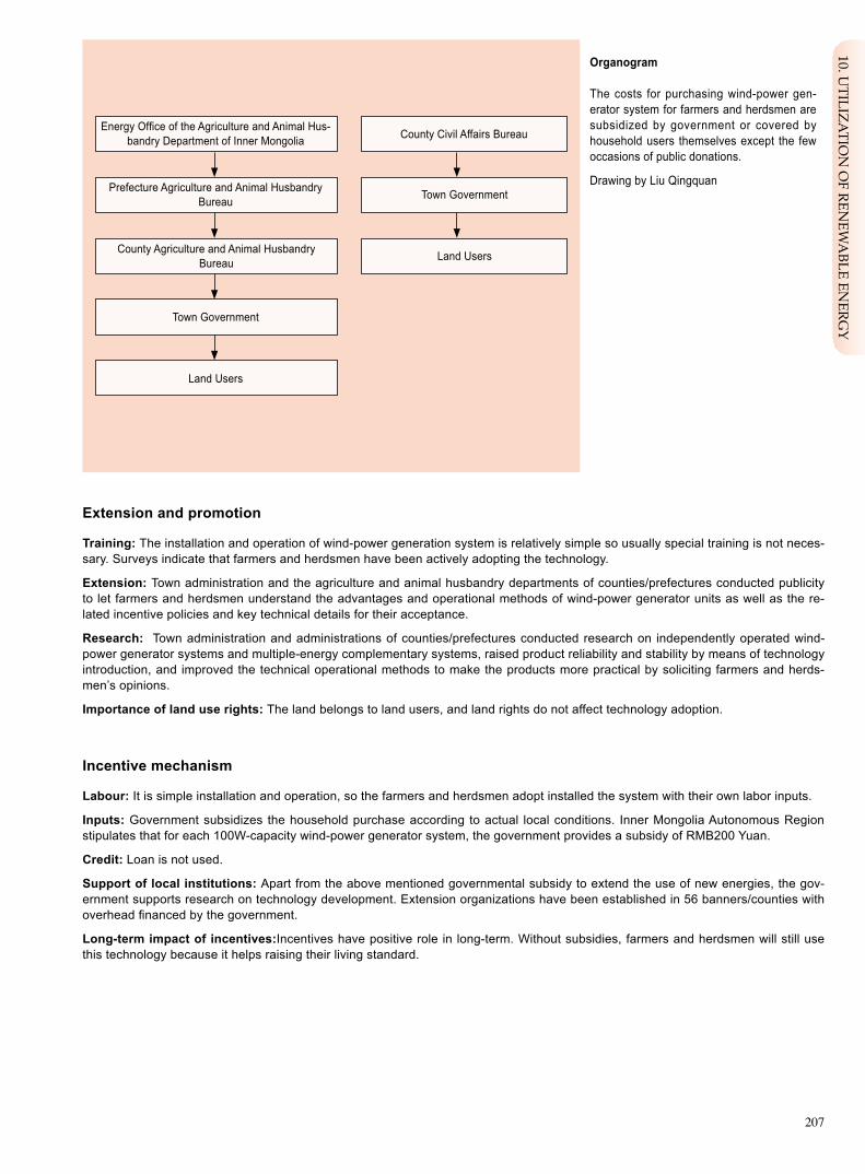
207
Extension and promotion
Training: The installation and operation of wind-power generation system is relatively simple so usually special training is not neces-sary. Surveys indicate that farmers and herdsmen have been actively adopting the technology.
Extension: Town administration and the agriculture and animal husbandry departments of counties/prefectures conducted publicity to let farmers and herdsmen understand the advantages and operational methods of wind-power generator units as well as the re-lated incentive policies and key technical details for their acceptance.
Research: Town administration and administrations of counties/prefectures conducted research on independently operated wind-power generator systems and multiple-energy complementary systems, raised product reliability and stability by means of technology introduction, and improved the technical operational methods to make the products more practical by soliciting farmers and herds-men’s opinions.
Importance of land use rights: The land belongs to land users, and land rights do not affect technology adoption.
Incentive mechanism
Labour: It is simple installation and operation, so the farmers and herdsmen adopt installed the system with their own labor inputs.
Inputs: Government subsidizes the household purchase according to actual local conditions. Inner Mongolia Autonomous Region stipulates that for each 100W-capacity wind-power generator system, the government provides a subsidy of RMB200 Yuan.
Credit: Loan is not used.
Support of local institutions: Apart from the above mentioned governmental subsidy to extend the use of new energies, the gov-ernment supports research on technology development. Extension organizations have been established in 56 banners/counties with overhead financed by the government.
Long-term impact of incentives:Incentives have positive role in long-term. Without subsidies, farmers and herdsmen will still use this technology because it helps raising their living standard.
Organogram The costs for purchasing wind-power gen-erator system for farmers and herdsmen are subsidized by government or covered by household users themselves except the few occasions of public donations.
Drawing by Liu Qingquan
Energy Office of the Agriculture and Animal Hus-bandry Department of Inner Mongolia
Town Government
County Civil Affairs Bureau
Prefecture Agriculture and Animal Husbandry Bureau Town Government
Land Users
Land Users
County Agriculture and Animal HusbandryBureau
10. UTILIZA
TION
OF REN
EWA
BLE ENERG
Y

208
Monitoring and evaluation
Monitored aspects Methods and indicatorsBio-physical On-site measurement of the wind velocity.
Technical On-site measurement of the generation capacity.
Socio-cultural Interview visits to farmers and herdsmen on operation and maintenance conditions.
Economic/production Types of compatible electrical appliances.
Area treated Inventory on numbers of household users.
No. of land users involved Survey of the household users.
Management of approach Local government obtain statistical data, determine the subsidy amount.
Impacts of the approach
Changes as result of monitoring and evaluation: Governmental support and recognition of farmers and herdsmen lead to wide-spread application of the technology. With improved sense in environmental protection, farmers and herdsmen would ask for up-dated technology and equipment including using wind energy resource.
Improved soil and water management: The technology is implemented by rural or pastoral households without obvious impact on the soil and water management.
Adoption of the approach by other projects/land users: The technology is simple so it is accepted very easily.
Sustainability: Without long-term incentive support, the land users will still use the technology.
Concluding statements
Strengthens and → how to sustain/improve
Legislation promoted the technology application → To further im-prove the extension system.
Subsidy incentives raise the adoption enthusiasm of the farmers and herdsmen → To further expand extension and application.
Meet the basic need of electricity by householders → To further expand dissemination and application of the technology.
Weaknesses and → how to overcome
High inputs of earlier stage → To continue the economic incentive support policy.
Incomplete maintenance service system → To make vigorous efforts in es-tablishing sound community based service system.
Key reference(s) [1] Hou Guoqing. Wind-power generation and the prospect in Inner Mongolia. Electricity Power Survey and Design. 2004,9(3):77-80. [2] Cai Jingyu. Inner Mongolia wind energy resource analysis and evaluation. International Electric Power for China.2004, 8(30:36-37.
Contact person(s) Liu Qingquan, Inner Mongolia Forestry Research Institute. Tel: 86-471-2280186. Email: [email protected]

209
Biogas Digester Jingyuan County of Gansu Province, China
By established facilities and use organic matter of animal manure, human waste, plant straw for anaerobic fermentation to produce inflammable biogas for uses of lighting, cooking with the residue liquid and dreg for high quality organic fertilizer.
The demonstration site is located at Jingyuan County of central Gansu Province, an arid county with annual rainfall 240 mm for rainfed agriculture. The vegetation cover of the county is 5.6% and the water and soil erosion affected area is 5359 square kilometers or 92.2% of total land area. The fragile ecological and serious land degra-dation made the locality a very poor place, short of fuel. Poverty and ecological deg-radation has formed a vicious circle. Energy scarcity problem that needs to be solved urgently is also a cutting point for curbing land degradation. Since 2000, with the support of relevant departments, biogas production technology has been introduced and extended in Jingyuan County. Due to its multiple functions in kitchen, toilet, ani-mal house etc., it has obvious social, ecological and economic benefits. The technol-ogy is easy and the maintenance is simple, so the extension is quick.
The construction procedures: location identification, digester type selection (e.g. rotational-flowed digester), elevation determination, earthwork, and construction of digester base, digester wall, feed and discharge chutes, proof seal layer and digester cover etc..
The operational management: pH value kept at 6.8-7.5; digester fermentation tem-perature maintained over 10 degrees Celsius; Replace desulfurizer every three months, stir frequently to ferment raw material, inspect often to ensure no leakage in the cover, pipeline etc.; frequent work in feeding and discharging, control the density of liquid material.
The functions of biogas digesters: (1) Ecologically, the use of biogas can reduce vegeta-tion damage, prevent land degradation. A biogas digester with capacity of 10 m3 can economize 2 tons of firewood every year, which is equivalent to the annual increment of 3.5 mu firewood forest; The dregs and residue liquid are organic fertilizers, the liquid can also be used for treatment of plant diseases and pests. (2) Social benefit. The biogas digester may offer over 70% clean energy of the household while reduc-ing the consumption of the conventional energies of firewood and coal. The life qual-ity, sanitary condition are improved and the working burden of women is alleviated. The use of biogas digester promotes social progress by raising the awareness of science and technology of the farmers to promote the construction of new socialist countryside. (3) Economically the biogas will increase the income of farmers. It can cut down the expenditure by 1500 Yuan for one year. Biogas use can promote live-stock development and as an environmental-friendly agriculture development model.
Left: The main part of the digester under con-struction. Photo by Wang Yaolin Right: The gas produced is used for indoor lighting (the gadget on wall is for desulphur-ization). Photo by Wang Yaolin
Location: Jingyuan County of Gansu Prov-ince (the loess plateau) Technology area: 5809.4km2 SWC measure: EngineeringLand use: Farmland/other Climate: AridWOCAT database reference: QTRelated approach: Rural Biogas Develop-ment – One Digester with Three Facilities Compiled by: Wang Yaolin, GEF/OP12 Proj-ect Management Office, Gansu Sand Control Research Institute; Chang Qing, Foreign Funded Ecological Project Office, Jingyuan County, Gansu Date: Revised on September 2007
Editors’ comments: The technology of bio-gas digester is a mature one, and now widely adopted in rural areas of China. It has special importance for arid, ecologically fragile coun-ties such as Jingyuan. It is playing increasingly important role in rural life. Now most farmers have realized its advantages and the enthusi-asm of application is high. However, the initial relatively higher investment restricts techno-logical extension larger scope.
10. UTILIZA
TION
OF REN
EWA
BLE ENERG
Y

210
Growing season: 180 days in succession, from April to September Soil fertility: moderateSoil texture: moderate (loamy) Surface stoniness: none Topsoil organic matter: moderate (<1%) Soil drainage: goodSoil erodibility: high
>4000 >4000 3000–4000 3500–4000 2000–3000 3000–3500 1500–2000 2500–3000 1000–1500 2000–2500 750–1000 1500–2000 500–750 1000–1500 250–500 1000–500 <250 <500
Soil depth (cm)
0–20 20–50 50–80 80–120 >120
Land use rights: individualLand ownership: collectives Market orientation: self useLevel of technical knowledge required: high to technical extensionists and high to land usersImportance of off-farm income: 10%-50% of total income
Human environment
Mixed land per household (hm2)
<1 1–2 2–5 5–15 15–50 50–100 100–500 500–1000 1000–10000 >10000
Annual crops
Water erosion
Forest Wind erosion Mechanical measures
Classification
Land use problemsLow vegetation cover, wind erosion, water erosion, barren soil, arid climate, fragile ecological condition.
Land use Climate Degradation SWC measure
Arid Technical function/impact main: - protect vegetation - reduce water erosion - prevent wind erosion
Environment
Natural Environment
Average annual rainfall (mm) Altitude (m a.s.l.) Landform Slope (%)
ridges
ridgeshill slopes
foot slopesvalley floors
mountain slopes
plains/plateaus
secondary: - improve soil - develop environmental friendly agriculture - reduce emission of co2
- increase income
very steep (>60)steep (30–60)hilly (16–30)rolling (8–16)moderate (5–8)gentle (2–5)flat (0–2)

211
feed openinggas tube removable cover
gas storage hydraulic room
discharge chute
fermentation digester
feed chute
Establishment inputs and costs per hm2
Inputs Costs (US$) % met by land user
Materials,cement, sand, cooker etc. 267 %
Labour 40 100%
Other: transport fee 40 100%
TOTAL 347 23%
1. Planning: Make efforts to make digester functional 4 in 1, I.E digester, toilet, animal house and kitchen. In general, the household used of biogas digester is 8-12 m3. 2. Location selection (leeward and not facing the sun), about 25m away to the kitchen. 3. Elevation determination to guarantee smooth inflow of the manure of the humans and livestock. 4. Get the raw materials ready. 5. Alignment and start the earthwork.6. Construct the main digester including the proof seal, cover plate, feed chute, and discharge chute. Establish 2- 3 m3. space for fertilizer storage that is linked with discharge chute to facilitate the discharge. 7. Install kitchen range with affiliated utilities.8. input the inoculum and raw material of manure etc. for fer-mentation.
1. Check to see whether the gas production is normal. 2. Check to identify any possible leakage of gas. 3. Check to see whether feeding is needed. 4. Check the use of desulfurizer.5. Safety checking.
The checking is done for every 6 days.
Maintenance/recurrent inputs and costs per hm2 per year
Inputs Costs (US$) % met by land user
Labour 80 100%
TOTAL 80 100%
Technical drawing
Rural home use hydraulic cylinder-type hydraulic biogas digester
Discharge chute is connected with the toilet and animal houses, the digester should not be higher than the toilet, animal houses, and nearby residential houses.
For ordinary uses, the inner diameter of the digester is 2.7m. digester height 1m; low-spherical digester cover vector height: 54cm; low-spherical digester base vector height: 34cm; hydraulic pressure room: 1.2m long, 1.0m wide.
Remarks: labor price calculated at RMB40 Yuan/day,equipment at permanent use cost, material cost is estimated; other costs by con-tracted annual maintenance.
Implementation activities, inputs and costs
10. UTILIZA
TION
OF REN
EWA
BLE ENERG
Y
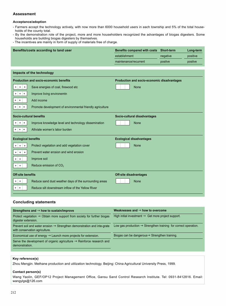
212
Assessment
Acceptance/adoption- Farmers accept the technology actively, with now more than 6000 household users in each township and 5% of the total house-
holds of the county total. - By the demonstration role of the project, more and more householders recognized the advantages of biogas digesters. Some
households are building biogas digesters by themselves. - The incentives are mainly in form of supply of materials free of charge.
Benefits/costs according to land user Benefits compared with costs Short-term Long-term
establishment negative positive
maintenance/recurrent positve positve
Impacts of the technology
Production and socio-economic benefits Production and socio-economic disadvantages
+ + + Save energies of coal, firewood etc None
+ + + Improve living environemtn
+ + Add income
+ + + Promote development of environmental friendly agriculture
Socio-cultural benefits Socio-cultural disadvantages
+ + + Improve knowledge level and technology dissemination None
+ + + Alliviate women’s labor burden
Ecological benefits Ecological disadvantages
+ + + Protect vegetation and add vegetation cover None
+ + + Prevent water erosion and wind erosion
+ + Improve soil
+ + Reduce emission of CO2
Off-site benefits Off-site disadvantages
+ + Reduce sand dust weather days of the surrounding areas None
+ + Reduce silt downstream inflow of the Yellow River
Concluding statements
Key reference(s) Zhou Mengjin. Methane production and utilization technology. Beijing: China Agricultural University Press, 1999.
Contact person(s) Wang Yaolin, GEF/OP12 Project Management Office, Gansu Sand Control Research Institute. Tel: 0931-8412816. Email: [email protected]
Strengthens and → how to sustain/improve
Protect vegetation → Obtain more support from society for further biogas digester extension.
Prevent soil and water erosion → Strengthen demonstration and inte-grate with conservation agriculture.
Economical use of energy → Launch more projects for extension.
Serve the development of organic agriculture → Reinforce research and demonstration.
Weaknesses and → how to overcome
High initial investment → Get more project support.
Low gas production → Strengthen training for correct operation.
Biogas can be dangerous→ Strengthen training.

213
Rural Biogas Development – One Digester with Three Facilities Jingyuan County of Gansu Province, China
A campaign of “One digester with three facilities”, launched by government and pro-moted by demonstration, is going on Jingyuan County of Gansu Province. This cam-paign is aimed to improve biogas digester and three facilities used in kitchen, animal house and toilet.
The demonstration project is located in Jingyuan County of Gansu Province. His-torically, Jingyuan is a naturally harsh region, where shortage of “three materials” (materials for fuel, fodder and building) are felt. Furthermore, ecological degradation has led to poverty of rural community. In 1970s government encourage people to use biogas digesters, and in 1980s government called people to use firewood saving stoves and solar cookers, which to a certain extent alleviated the rural shortage of fuel material. However, due to financial and technical constraints the biogas applica-tion had a very limited progress.
In May 1979 National Biogas Application Conference was convened. After this con-ference a Biogas Office was set up in Jingyuan County dealing with promotion of biogas technology. During period of tenth Five-year Plan entire Gansu Province implemented a pilot village programme entitled “Ecological Homestead and Enrich-ing People”, sponsored by the Ministry of Agriculture, in addition to the National Programme of Conversion of Farmland to Forest and Programme of Poverty Reduc-tion. Some farmers spontaneously made investment to build biogas digesters. Since 2003 government has launched a series of programmes, including programme of rural biogas digesters (financed by treasure bonds) and large/medium-sized biogas engineering programme (financed by Ministry of Agriculture). Powered by these pro-grammes, more households were using biogas, and the scope of use was expanded to cover integrated uses in addition to lighting, cooking and boiling etc. In 2003, Jingyuan county had 121 certified biogas workers, and over 2100 sets of biogas di-gesters, including 1200 sets with advanced technology (lateral hydraulic automatic rotational-flowed digester). Four pilot villages were arranged. At present total of 6000 households are using biogas in the county.
The technology extension of biogas digesters is made mainly through project demon-stration under the leadership of the county energy office. The extension approaches are: training, village meetings, on-the-spot explanations, handouts distribution. Train-ees are the rural biogas technicians, administration staff as well as the farmers. Gener-ally speaking, the village meeting is convened firstly for farmers to discuss and decide who should be financed by the project for biogas digester construction. In course of the publicity and construction, the county energy office staffs are responsible for answering the inquiries. The project or government will supply the building materials while farm-ers are responsible for transportation and labor input. The household who uses “one digester with three facilities” has a advanced digester with features of simple structure, reasonable layout and convenient operation. It also features more automatic operation, high gas production, easy cleaning and environment friendly.
Left: Biogas digester under construction. Photo by Chang Qing Right: Biogas used for cooking. Photo by Wang Yaolin
Location: Jingyuan County, Gansu Province Land use: Farmland/otherClimate: Arid WOCAT database reference: QARelated technology: Biogas Digester Compiled by: Wang Yaolin, GEF/OP12 Proj-ect Management Office, Gansu Sand Control Research Institute; Chang Qing, Foreign Funded Ecological Project Office, Jingyuan County, Gansu Date: Revised on September 2007
Editors’ comments: The technology of “one digester with three facilities is project initiated by government, but now it is spontaneously adopted in rural communities. With increased number of users, this technology will play an important role in protection and restoration of degraded environment, reduction of pov-erty and development of new village. It is a practical and reliable method of solving rural energy problem. This technology has ahuge potential, but it needs financial and technical support from government.
10. UTILIZA
TION
OF REN
EWA
BLE ENERG
Y

214
Problem, objectives and constraints
Problem- Community lacks funds for biogas digester construction. - Community lacks biogas knowledge. - Community lacks effective organization.- Households lack fuel. - Farmers extremely poor. - Arid climate, low rainfall, low land productivity.
Objectives- Establish effective extension mechanism. - Raise community participation capability. - Alleviate soil erosion. - Provide energy to rural area to meet daily needs. - Improve rural living environment.
Constraints addressed
Major Specification Treatment
Low knowledge Some farmers feel difficult to learn and accept new technology, Increase training intensity. level and can not manage and operate the biogas facilities correctly.
Short of fund Current technological application is supported by project. Seek more social support and governmental special finances. Those areas without project are difficult to adopt it because of high initial investment.
Minor Specification Treatment
Natural factor Low temperature in late fall, early spring and winter has an To keep biogas digester warm by combining animal breeding influence on biogas output. in warm house.
Participation and decision making
Target groups
Land user Decision maker Planner
Decisions on choice of the technology: Land users and the government. Decisions on method of implementing the technology: Government and farmers. Approach designed by: Local experts.
Community involvement
Phase Phase Phase
Initiation Passive The departments at levels of Province, prefecture and county conduct surveys, convene meetings, carry out publicity to let villagers aware of the purpose of project.
Planning Active Villagers have consultations with design staff/technicians.
Implementation Self mobilization Farmers contribute labor and participate in the construction work.
Monitoring/evaluation Active Related departments explain the purpose of monitoring to the villagers and en-courage them to participate in monitoring recording and reporting.
Research Active Join In the digester construction and analysis of socio-economic effect during process of intro duction and research of new technologies.
Differences in participation of men and women: Male labor participate in the main part of physical work, including material pur-chasing, transportation and recruitment of technicians etc..
Approach costs met by
households 23%
Project finance 77%
TOTAL(2600 RMB Yuan) 100%

215
Extension and promotion
Training: The contents of training are: biogas digester construction, operation, maintenance and the use of dregs and residue liquid. The training forms are: demonstrations, meetings, wall newspaper, household visits and brochure distribution. Training is conducted mainly by county-level technicians. The training plays an extremely important role in technological application and improved knowl-edge of farmers.
Extension: The extension is organized by County Energy Office with collaboration efforts by the township government. The exten-sion forms include demonstration, on-the-spot explanation, interviews etc. Some farmers with good cultural education can easily accept new things. They can scale up the technology through visits, discussion meetings to other householders. The extension has positive influence to both the extensionists and farmers.
Research: Research work has been mainly conducted at national and provincial levels, with little participation by farmers.
Importance of land use rights: Biogas digester is normally located in or around the home courtyard, so land use right does not af-fect the technology application.
Incentive mechanism
Labour: In process of the biogas digester construction, the labor is not paid, while the technical service employed should be paid by the project.
Inputs: Building material such as cement, brick, plastic pipe etc., are wholly or partially financed by the project while working tools such as shovels, tractor and pickaxe is supplied by farmer households.
Credit: : None.
Support of local institutions: Energy Office is established at the county level responsible for training and the extension and apply-ing for assistance of biogas digester project support from country government or relevant international organizations.
Long-term impact of incentives: With the support of projects, the application scope of the technology is expanding quickly, some households of better economic condition are raising fund by themselves to construct biogas digesters. Without the support of proj-ects, extension and application of the technology will shrink.
Organogram Projects related with the technologies of “one digester with three facilities” are financed by the National Energy Office, and affairs related to international support will be dealt with by provinces and counties.
Ministry of Agriculture, National Energy Office
County Agriculture and Animal Husbandry Bureau
Provincial Agriculture and Animal Husbandry Department,Provincial Energy Office
Township Government
City/Prefecture Agriculture and Animal Husbandry Bureau
Land Users
10. UTILIZA
TION
OF REN
EWA
BLE ENERG
Y

216
Monitoring and evaluation
Monitored aspects Methods and indicatorsBio-physical Field vegetation cover, ratio change of coal consumption and firewood consumption, the temperature inside the digester. By site observations and tests.
Technical Gas production is obtained by observations and tests.
Socio-cultural Survey the knowledge level of farmers on biogas and their understanding of organic agriculture.
Economic/production Income and crops production.
Area treated The entire county.
No. of land users involved Annual survey of the number of adoption household of the biogas digesters.
Management of approach Observe and record household biogas users, along with introduction, inputs and integrated development (planting, aquaculture etc.) of new technologies.
Impacts of the approach
Changes as result of monitoring and evaluation: At the beginning, the extension was done by efforts of government cadres to mobilizing the farmers. Now it is the government-project- farmer integrated extension pattern. Most farmers now has strong wishes to build biogas digesters and the biogas digester has evolved from single energy use to the present pattern of “Four-in-one” to cov-er organic agriculture development, aquaculture etc. and the users are extended from farmer household to governmental and social institutions, enterprises, schools etc..
Improved soil and water management: Protect vegetation and curb degradation of the ecosystem; the dregs and the residue liq-uid as fertilizer can help increase soil organic matter, produce green food and improve rural environment.
Adoption of the approach by other projects/land users: The technology has been adopted in the county as well as the sur-rounding areas.
Sustainability: The sustainability will be higher if project support or other external fund sources are available.
Concluding statements
Strengthens and → how to sustain/improve
Governmental extension combined with farmer spontaneous adop-tion of the technology → Reinforce propaganda, training.
Increase capability and knowledge level of farmers → Access more projects to cover more biogas users.
Add income → Reinforce integrated development.
Promote organic agriculture → Further develop the uses of resi-dues.
Weaknesses and → how to overcome
Relatively complicated technology → Reinforce training and propaganda.
The inputs are higher → Obtain more external support.
Key reference(s) Wang Xiaohua etc. Impact of rural household biogas consumption and economic behavior, College of Technology, Nanjing Agricul-tural University, 2005.
Contact person(s) Wang Yaolin, GEF/OP12 Project Management Office, Gansu Sand Control Research Institute. Tel: 0931-8412816. Email: [email protected]

Acknowledgements
Thanks are first given to land users who have worked in China’s dryland areas for long time, it was them who have created the best practices of sustainable land management and provided these practices to be shared with other people all over the world.
We would like to thank the authors and technical contributors of the proceedings, who have collected a large amount of first hand data, and have made summarization of traditional techniques and methods of land degradation in China, they were very patient to answer the questions of the WOCAT questionnaire, and edited the text according to the format of WOCAT cases studies. Meanwhile, we would like to thank all reviewers who participated in the review of the reported achievements.
During the revision and improvement of the reports, we have solicited comments from a number of experts and scholars in different fields. Special thanks are given to Professor ZHANG Kebin and Professor WANG Xian from Beijing Forestry University and Professor WANG Yaolin from Gansu Desert Control Research Institute for their careful checks and revisions of the manuscripts. We would like to thank Mr. ZHENG Rui, Senior Officer of the Secretariat of UNCCD for his valuable comments on editing and suggestions for the English translation.
editorOctober, 2008

图书在版编目(CIP)数据
中国干旱地区土地退化防治最佳实践 = Best Practices for Land Degradation Control in Dryland Areas of China / 中
国-全球环境基金干旱生态系统土地退化防治伙伴关系,中国-全球干旱区土地退化评估项目 编 . —北京:
中国林业出版社,2008.11
ISBN 978-7-5038-5340-1
Ⅰ. 中… Ⅱ. ①中… ②中… Ⅲ. 干旱区-土地退化-防治-研究-中国-英文 Ⅳ. F323.211
中国版本图书馆CIP数据核字(2008)第162124号
China Forestry Publishing House 2008
All rights reserved. No part of this publication may be reproduced, stored in a retrieval system, or transmitted in any
form or by any means, electronic, mechanical, photocopying, recording or otherwise without the prior permission of the
publisher.
Printed in the People’s Republic of China
Chinese Publications Number of Archives Library: 2008-162124
ISBN 978-7-5038-5340-1
Best Practices for Land Degradation Control in Dryland Areas of China: PRC-GEF Partnership on Land
Degradation in Dryland Ecosystems, China-Land Degradation Assessment in Drylands
I. China… II. ① China… ② China… III. Dryland Areas - Land Degradation - Prevention - Research - China
- English IV. F323.211
Editors: Wu Jinyou, Yu Jiefen, Designer: Fu Xiaobin
China Forestry Publishing House
No. 7 Liuhai Hutong, Xicheng District
Beijing, P.R. China, 100009
E-mail: [email protected]
Tel: 66176967
Price: RMB 139.00
c


