68
DEPARTMENT OF ENVIRONMENTAL CONSERVATION New York State Better Site Design New York State Department of Environmental Conservation Division of Water April 2008
DEPARTMENT OF ENVIRONMENTAL CONSERVATIONNew York State
Better Site Design
New York State Department of Environmental Conservation
Division of Water
April 2008

Document Prepared by:
Horsley Witten Group with assistance from the
Center for Watershed Protection
Better Site Design
1
BETTER SITE DESIGN 1 INTRODUCTION 1.1 Purpose The purpose of this document is to provide guidance to developers and designers to plan for and implement better site-design practices for new development and redevelopment projects. While reducing the effects of stormwater runoff may be achieved through both regulatory and non-regulatory techniques, this document focuses on the site-level planning and design tools available to the development community. As research, technology and information transfer have improved over recent years, alternative approaches are being sought by the public and regulatory boards to reduce the effects of stormwater runoff from new development and redevelopment. Developers and designers also are seeking alternatives to expedite permitting processes, reduce construction costs, reduce long-term operation and maintenance costs and increase property values. What is better site design, and how does it differ from conventional design? Better site design incorporates non-structural and natural approaches to new and redevelopment projects to reduce effects on watersheds by conserving natural areas, reducing impervious cover and better integrating stormwater treatment. For the purposes of this document, conventional design can be viewed as the style of suburban development that has evolved during the past 50 years and generally involves larger lot development, clearing and grading of significant portions of a site, wider streets and larger cul-de-sacs, enclosed drainage systems for stormwater conveyance and large “hole-in-the-ground” detention basins. The aim of better site design is to reduce the environmental-impact “footprint” of the site while retaining and enhancing the owner/developer’s purpose and vision for the site. Many of the better site-design concepts employ non-structural on-site treatment that can reduce the cost of infrastructure while maintaining or even increasing the value of the property relative to conventional designed developments. The goals of better site design include: • Prevention of stormwater effects rather than having to mitigate for them • Management of stormwater (quantity and quality) as close to the source as possible and
minimization of the use of large or regional collection and conveyance • Preservation of natural areas, native vegetation and reduction of the effect of on watershed
hydrology • Usage of natural drainage pathways as a framework for site design • Utilization of simple, non-structural methods for stormwater management that are lower cost
and lower maintenance than structural controls • Creation of a multifunctional landscape

Better Site Design
2
1.2 Scope and Context/How to Use this Document The scope and context of this document is to present developers and site designers with a series of alternatives to conventional stormwater management practices to reduce the effect development has on the watershed (e.g., peak stream flow, stormwater runoff, habitat, etc.). The information presented is intended to provide guidance during the site-planning process on how to “re-think” the traditional site layout and design approach for both new and redevelopment projects. This document provides an overview of the broad categories of better site design, the specific practices under each category, guidance on evaluating appropriate practices by weighing the benefits and risks of each practice and further guidance on each individual practice. Two case studies are also presented, one for a residential development and one for a commercial development, that illustrate conventional site designs versus “better” site designs. This document provides general guidance on how to choose the appropriate design technique but does not provide detailed design requirements and specifications for each of these practices. A list of resources on where to find this information is provided in the profile sheets in Section 2.4. 1.3 Key Terminology Better site design - Incorporates non-structural and natural approaches to new and redevelopment projects to reduce effects on watersheds by conserving natural areas, reducing impervious cover and better integrating stormwater treatment. Conservation design - Includes laying out the elements of a development project in such a way that the site design takes advantage of a site’s natural features, preserves the more sensitive areas and identifies any site constraints and opportunities to prevent effects. Conventional site design - For the purposes of this document, conventional design can be viewed as the style of suburban development that has evolved during the past 50 years and generally involves larger lot development, clearing and grading of significant portions of a site, wider streets and larger cul-de-sacs, enclosed drainage systems for stormwater conveyance and large “hole-in-the-ground” detention basins. Total impervious area - This is the total area within a watershed of all materials or structures on or above the ground surface that prevents water from infiltrating into the underlying soils. Impervious surfaces include, without limitation: paved parking lots, sidewalks, rooftops, patios, and paved, gravel and compacted-dirt surfaced roads. Gravel parking lots and/or compacted urban soils are often not included in total impervious area but may have hydrologic characteristics that closely resemble paved areas. Natural areas - This is undisturbed land or previously disturbed land that has recovered and that retains pre-development hydrologic and water quality characteristics.

Better Site Design
3
New development – Any construction or disturbance of a parcel of land that is currently undisturbed or unaltered by human activities and in a natural state. Non-structural stormwater control – Natural measures that reduce pollution levels, do not require extensive construction or engineering efforts and/or promote pollutant reduction by eliminating the pollutant source. Redevelopment – Any land disturbance for construction, alteration or improvement where the existing land use is commercial, industrial, institutional or multi-family residential. Structural stormwater control – Devices that are engineered and constructed to provide temporary storage and treatment of stormwater runoff. 1.4 The Benefits of Better Site Design The use of better site design can have a number of benefits that extend beyond improving water quality and stormwater runoff management, including: • Reduced construction costs • Reduced long-term operation and maintenance costs • Increased property values • Easier compliance with wetland and other resource protection regulations • More open space for recreation • More pedestrian-friendly neighborhoods • Protection of sensitive forests, wetlands and habitats • More aesthetically pleasing and naturally attractive landscape 1.5 The Obstacles of Better Site Design Some obstacles exist or are perceived in the implementation of better site-design practices. Such as: • Public perception of a particular practice may not be favorable • Local codes may not allow for particular design elements • Capital costs and/or operation and maintenance costs for some practices may not always be
less expensive than conventional designs. Typical perceived obstacles and realities specific to each practice are presented in the individual practice profile sheets in Section 2.4.

Better Site Design
4
2 STORMWATER BETTER SITE DESIGN PRACTICES 2.1 Better Site-Design Categories and Listing of Practices Stormwater better site-design practices and techniques covered in this document are grouped into the following three categories:
Preservation of Natural Features and Conservation Design: Preservation of natural features includes techniques to foster the identification and preservation of natural areas that can be used in the protection of water resources. Conservation design includes laying out the elements of a development project in such a way that the site design takes advantage of a site’s natural features, preserves the more sensitive areas and identifies any site constraints and opportunities to prevent or reduce effects. Reduction of Impervious Cover: Reduction of impervious cover includes methods to reduce the amount of rooftops, parking lots, roadways, sidewalks and other surfaces that do not allow rainfall to infiltrate into the soil, in order to reduce the volume of stormwater runoff, increase groundwater recharge, and reduce pollutant loadings that are generated from a site. Use of Natural Features and Source Control for Stormwater Management: Use of natural features for stormwater management includes design strategies rather than structural stormwater controls to help manage and mitigate runoff. Source control for stormwater management includes elements to mitigate or manage stormwater in a natural or lower-impact manner.
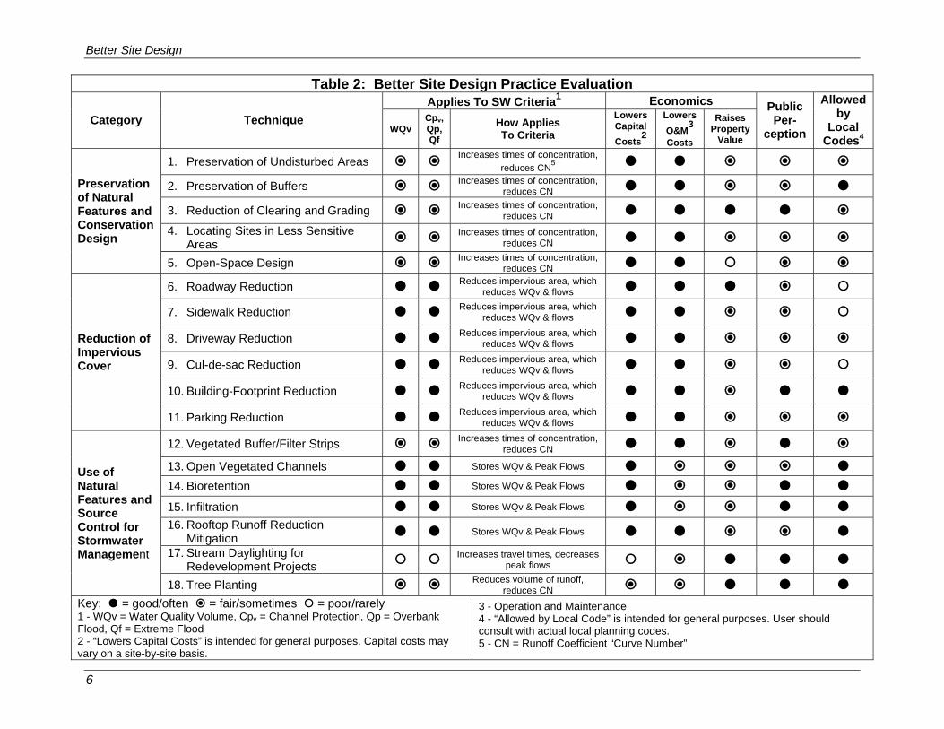
Table 1 lists the specific better site-design practices and techniques presented in this document for each of the three categories. An evaluation of each practice is presented in Table 2, and further detail on each site-design practice is provided in the profile sheets in section 2.4.
Table 1: Better Site-Design General Categories and Specific Practices Preservation of Natural Features and Conservation Design
1. Preservation of Undisturbed Areas 2. Preservation of Buffers 3. Reduction of Clearing and Grading 4. Locating Sites in Less Sensitive Areas 5. Open Space Design
Reduction of Impervious Cover 6. Roadway Reduction 7. Sidewalk Reduction 8. Driveway Reduction 9. Cul-de-sac Reduction 10. Building Footprint Reduction 11. Parking Reduction
Use of Natural Features and Source Control for Stormwater Management 12. Vegetated Buffer/Filter Strips 13. Open Vegetated Channels 14. Bioretention and Raingardens 15. Infiltration 16. Rooftop Runoff Reduction Mitigation 17. Stream Daylighting for Redevelopment Projects 18. Tree Planting

Better Site Design
5
2.2 Better Site-Design Planning Process Site design should be done in unison with the design and layout of stormwater infrastructure in attaining stormwater management and land use goals. The stormwater better site-design process used a three-step process as follows:
1. Avoiding the Impacts – Preserving natural features and use conservation design techniques
2. Reducing the Impacts – Reducing impervious cover.
3. Managing the Impacts – Using natural features and natural low-impact techniques to manage stormwater
The first step in the planning and design process is to avoid or minimize disturbance by preserving natural areas or strategically locating development based on the location of resource areas and physical conditions at a site. Once sensitive resource areas and site constraints have been avoided, the next step is to minimize the impact of land alteration by reducing impervious areas. Finally, for the areas that must be impervious, alternative and natural stormwater management techniques are chosen as opposed to the more routine structural, “pipe-to-pond,” approach. 2.3 Evaluating and Selecting Better Site Design Practices Part of the planning process for better site design includes choosing the appropriate practice or practices for a given site. Table 2 illustrates the various criteria and factors used to evaluate the feasibility of a particular design practice and are ranked as either good, fair or poor, or as often, sometimes or rarely. The factors presented in Table 2 that will help a developer decide which practices to choose include:
How the Practice Applies To Meeting New York State Stormwater Criteria – Does the practice help meet the water quality volume (WQv) criteria? Does the practice help provide the quantity controls such as channel protection (Cpv), overbank flood (Qp), and extreme flooding (Qf)? For descriptions of the criteria, see the New York State Stormwater Management Design Manual. (www.dec.state.ny.us/website/dow/toolbox/swmanual/#Downloads)
Economics – Does the practice decrease capital construction/infrastructure costs and decrease long-term operation and maintenance costs? Does the practice increase property values?
Public Perception – Is the practice well received by the public and something people will want to live with?
Local Codes – Do local codes, ordinances and regulations typically allow implementation of the practice?
Better Site Design
6
Table 2: Better Site Design Practice Evaluation Applies To SW Criteria1 Economics
Category Technique WQv
Cpv, Qp, Qf
How Applies To Criteria
Lowers Capital Costs2
Lowers O&M3 Costs
Raises Property
Value
Public Per-
ception
Allowed by
Local Codes4
1. Preservation of Undisturbed Areas Increases times of concentration, reduces CN5
2. Preservation of Buffers Increases times of concentration, reduces CN
3. Reduction of Clearing and Grading Increases times of concentration, reduces CN
4. Locating Sites in Less Sensitive Areas Increases times of concentration,
reduces CN
Preservation of Natural Features and Conservation Design
5. Open-Space Design Increases times of concentration, reduces CN
6. Roadway Reduction Reduces impervious area, which reduces WQv & flows
7. Sidewalk Reduction Reduces impervious area, which reduces WQv & flows
8. Driveway Reduction Reduces impervious area, which reduces WQv & flows
9. Cul-de-sac Reduction Reduces impervious area, which reduces WQv & flows
10. Building-Footprint Reduction Reduces impervious area, which reduces WQv & flows
Reduction of Impervious Cover
11. Parking Reduction Reduces impervious area, which reduces WQv & flows
12. Vegetated Buffer/Filter Strips Increases times of concentration, reduces CN
13. Open Vegetated Channels Stores WQv & Peak Flows 14. Bioretention Stores WQv & Peak Flows 15. Infiltration Stores WQv & Peak Flows 16. Rooftop Runoff Reduction
Mitigation Stores WQv & Peak Flows 17. Stream Daylighting for
Redevelopment Projects Increases travel times, decreases peak flows
Use of Natural Features and Source Control for Stormwater Management
18. Tree Planting Reduces volume of runoff, reduces CN
Key: = good/often = fair/sometimes = poor/rarely 1 - WQv = Water Quality Volume, Cpv = Channel Protection, Qp = Overbank Flood, Qf = Extreme Flood 2 - “Lowers Capital Costs” is intended for general purposes. Capital costs may vary on a site-by-site basis.
3 - Operation and Maintenance 4 - “Allowed by Local Code” is intended for general purposes. User should consult with actual local planning codes. 5 - CN = Runoff Coefficient “Curve Number”

Better Site Design
7
2.4 Better Site Design Practice Profile Sheets 2.4.1 Preservation of Natural Features and Conservation Design Preservation of natural features includes the techniques to foster the identification and preservation of natural areas that can be used in the protection of water resources by reducing stormwater runoff, providing runoff storage, reducing flooding, preventing soil erosion, promoting infiltration and removing stormwater pollutants. Conservation Design includes laying out the elements of a development project in such a way that the site design takes advantage of a site’s natural features, including areas to be protected as conservation areas, preserves the more sensitive areas and identifies any site constraints and opportunities (e.g., topography, soils, natural vegetation, wetlands, floodplains, shallow bedrock, high water table, etc.) to prevent both on-site and downstream stormwater effects. 2.4.2 Reduction of Impervious Cover Reduction of impervious cover includes methods to reduce the amount of rooftops, parking lots, roadways, sidewalks and other surfaces that do not allow rainfall to infiltrate into the soil, in order to reduce the volume of stormwater runoff, increase groundwater recharge and reduce pollutant loadings that are generated from a site. 2.4.3 Utilization of Natural Features and Source Control for Stormwater
Management Use of natural features for stormwater management includes design strategies that use existing or recreate natural features to help manage and mitigate runoff, rather than structural stormwater controls. Source control for stormwater management includes elements to mitigate or manage stormwater in a natural or lower-impact manner.

Better Site Design
8
Better Site Design Practice #1: Preservation of Undisturbed Description: Important natural features and areas such as undisturbed forested and native vegetated areas, natural terrain, riparian corridors, wetlands and other important site features should be delineated and placed into permanent conservation areas.
Key Benefits Typical Perceived Obstacles and Realities
• Helps to preserve a site’s natural hydrology and water balance
• Can act as a non-structural stormwater feature to promote additional filtration and infiltration
• Can help to preserve a site’s natural character, habitat and aesthetic appeal
• Has been shown to increase property values for adjacent parcels
• Can reduce structural stormwater management storage requirement and may be used as a “stormwater credit
• Preserved conservation areas may limit the development potential of a site – With clustering and other development incentives, development yield can be maintained.
• Preserved habitats may harbor undesirable wildlife and insects – Most people enjoy viewing wildlife; native vegetation does not provide a food source for most vermin; continued education is necessary to show that humans and wildlife can co-exist, even at the neighborhood level.
• Preserved areas may represent a fire hazard – Clearing setbacks and target vegetation around residential structures can reduce property damage potential.
USING THIS PRACTICE • Delineate and define natural conservation areas before performing site layout and design. • Ensure that conservation areas and native vegetation are protected in an undisturbed state
through the design, construction and occupancy stages. Discussion Conservation of natural areas such as undisturbed forested and native-vegetated areas, natural terrain, riparian corridors and wetlands on a development project can help to preserve pre-development hydrology of the site and aid in reducing stormwater runoff and pollutant load. Undisturbed vegetated areas also promote soil stabilization and provide for filtering and infiltration of runoff. Natural conservation areas are typically identified through a site-analysis stage using mapping and field-reconnaissance assessments. Areas proposed for protection should be delineated early in the planning stage, long before any site design, clearing or construction begins. When done before the concept-plan phase, the planned conservation areas can be used to guide the layout of a project. Figure 1 shows components of a natural resources inventory map with proposed conservation areas delineated.
Preservation of Natural Features
and Conservation

Better Site Design
9
Preservation areas should then be incorporated into site-development plans and clearly marked on all construction and grading plans to ensure that construction activities are kept out of these areas and that native vegetation is undisturbed. The boundaries of each conservation area should be mapped by carefully determining the limit which should not be crossed by construction activity.
Once established, natural conservation areas must be protected during construction and managed after occupancy by a responsible party able to maintain the areas in a natural state in perpetuity. Typically, conservation areas are protected by legally enforceable deed restrictions, conservation easements and a maintenance agreement. When all of these measures are applied, a permanently protected natural area can be applied as a “stormwater credit” to reduce the structural stormwater management measures (see Figure 2 for a representative project illustrating natural resource area protection). Additional Guidance Arendt, Randall. 1996. Conservation Design for Subdivisions: A Practical Guide to Creating
Open Space Networks. American Planning Association. Chicago, IL. Available from the American Planning Association at www.planning.org
Figure 2: Aerial Photograph of Development Project Illustrating Preservation of Undisturbed Natural Areas
(Source: Arendt, 1996)
Figure 1: Example of Natural Resource Inventory Plan (Source: Georgia Stormwater Manual, 2001)
Stream
Wetland
Undisturbed Forest
Proposed Conservation Area

Better Site Design
10
Center for Watershed Protection. 1998. Better Site Design: A Handbook for Changing Development Rules in Your Community. Available from www.cwp.org
Prince George’s County, MD. June 1999. Low-Impact Development Design Strategies: An
Integrated Design Approach. Prince George’s County, Maryland, Department of Environmental Resources, Largo, Maryland. Available from www.epa.gov

Better Site Design
11
Better Site Design Practice #2: Preservation of Natural Features Preservation of Buffers and Conservation Design Description: Naturally vegetated buffers should be defined, delineated and preserved along perennial streams, rivers, shorelines and wetlands.
Key Benefits Typical Perceived Obstacles and Realities
• Riparian buffers treat stormwater and improve water quality
• Can be used as nonstructural stormwater infiltration zones
• Keep structures out of the floodplain and provide a right-of-way for large flood events
• Help to preserve riparian ecosystems and habitats
• Can serve as recreational areas
• A buffer credit can be taken if allowed by the local review authority.
• Buffers may result in a potential loss of developable land – Regulatory tools or other incentives may be available to protect the interests of property owners
• Private landowners may be required to provide public access to privately held stream buffers – Effective buffers can be maintained in private ownership through deed restrictions and conservation easements
• Excessive nuisance species will be present due to the natural buffer area - Forested buffers do not encourage nuisance vegetative species, and animal habitation can be controlled at the outer zone of the buffer.
USING THIS PRACTICE • Delineate and preserve naturally vegetated riparian buffers (define the width, identify the
target vegetation, designate methods to preserve the buffer indefinitely) • Ensure that buffers and native vegetation are protected throughout planning, design,
construction and occupancy • Consult local planning authority for minimum buffer width and/or recommended width. Discussion A riparian buffer is a special type of natural conservation area along a stream, wetland or shoreline where development is restricted or prohibited. The primary function of buffers is to protect and physically separate a stream, lake, coastal shoreline or wetland from future disturbance or encroachment. If properly designed, a buffer can provide stormwater management functions, can act as a right-of-way during floods, and can sustain the integrity of water-resource ecosystems and habitats. An example of a riparian stream buffer is shown in Figure 3.

Better Site Design
12
Forested riparian buffers should be maintained and reforestation should be encouraged where no wooded buffer exists. Proper restoration should include all layers of the forest plant community, including understory, shrubs and groundcover, not just trees. A riparian buffer can be of fixed or variable width but should be continuous and not interrupted by impervious areas that would allow stormwater to concentrate and flow into the stream without first flowing through the buffer.
Ideally, riparian buffers should be sized to include the 100-year floodplain as well as steep banks and freshwater
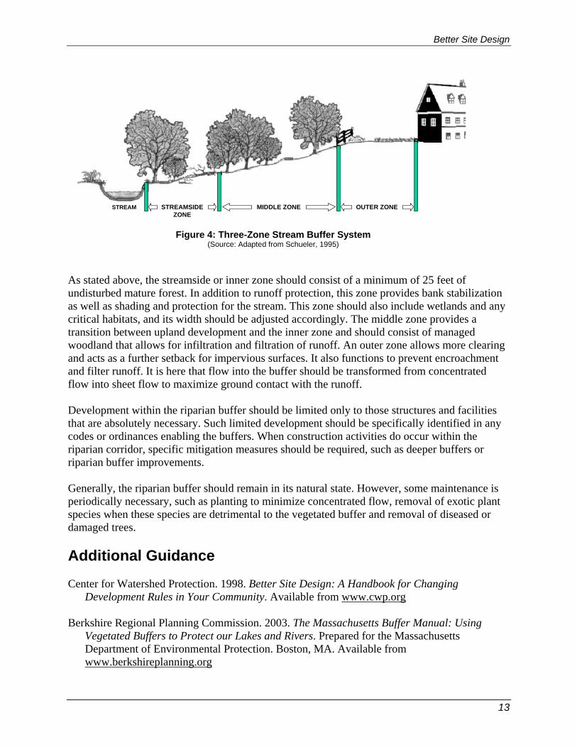
wetlands. The buffer depth needed to perform properly will depend on the size of the stream and the surrounding conditions, but a minimum 25-foot undisturbed vegetative buffer is needed for even the smallest perennial streams, and a 50-foot or larger undisturbed buffer is ideal. Even with a 25-foot undisturbed buffer, additional zones can be added to extend the total buffer to at least 75 feet from the edge of the stream. The three distinct zones within the 75-foot depth are shown in Figure 4. The function, vegetative target and allowable uses vary by zone as described in Table 3. These recommendations are minimum standards for most streams. Some streams and watersheds may benefit from additional measures to ensure adequate protection. In some areas, specific state laws or local ordinances already require stricter buffers than are described here. The buffer widths discussed are not intended to modify or supersede wider or more restrictive buffer requirements that are already in place.
Table 3: Riparian Buffer Management Zones (Source: Adapted from Schueler, 1995)
Streamside Zone Middle Zone Outer Zone
Width Minimum 25 feet plus wetlands and critical habitat
Variable, depending on stream order, slope, and 100-year floodplain (min. 25 ft.)
25-foot minimum setback from structures
Vegetative Target
Undisturbed mature forest. Reforest if necessary.
Managed forest, some clearing allowed.
Forest encouraged, but usually turfgrass.
Allowable Uses Very restricted (e.g., flood control, utility easements, footpaths)
Restricted (e.g., some recreational uses, some stormwater controls, bike paths)
Unrestricted (e.g., residential uses, including lawn, garden, most stormwater controls)
Figure 3: Riparian Stream Buffer (Source: Georgia Stormwater Manual, 2001)
Better Site Design
13
As stated above, the streamside or inner zone should consist of a minimum of 25 feet of undisturbed mature forest. In addition to runoff protection, this zone provides bank stabilization as well as shading and protection for the stream. This zone should also include wetlands and any critical habitats, and its width should be adjusted accordingly. The middle zone provides a transition between upland development and the inner zone and should consist of managed woodland that allows for infiltration and filtration of runoff. An outer zone allows more clearing and acts as a further setback for impervious surfaces. It also functions to prevent encroachment and filter runoff. It is here that flow into the buffer should be transformed from concentrated flow into sheet flow to maximize ground contact with the runoff. Development within the riparian buffer should be limited only to those structures and facilities that are absolutely necessary. Such limited development should be specifically identified in any codes or ordinances enabling the buffers. When construction activities do occur within the riparian corridor, specific mitigation measures should be required, such as deeper buffers or riparian buffer improvements. Generally, the riparian buffer should remain in its natural state. However, some maintenance is periodically necessary, such as planting to minimize concentrated flow, removal of exotic plant species when these species are detrimental to the vegetated buffer and removal of diseased or damaged trees. Additional Guidance Center for Watershed Protection. 1998. Better Site Design: A Handbook for Changing
Development Rules in Your Community. Available from www.cwp.org Berkshire Regional Planning Commission. 2003. The Massachusetts Buffer Manual: Using
Vegetated Buffers to Protect our Lakes and Rivers. Prepared for the Massachusetts Department of Environmental Protection. Boston, MA. Available from www.berkshireplanning.org
Figure 4: Three-Zone Stream Buffer System (Source: Adapted from Schueler, 1995)
STREAMSIDEZONE
MIDDLE ZONE OUTER ZONESTREAM

Better Site Design
14
Maine Department of Environmental Protection. 1998. The Buffer Handbook: A Guide to
Creating Vegetated Buffers for Lakefront Properties. Maine DEP. Augusta, ME. Available from http://www.state.me.us/dep/blwq/doclake/publake.htm
Schueler, T. 1995. Site Planning for Urban Stream Protection. Prepared for: Metropolitan
Washington Council of Governments. Washington, DC. Center for Watershed Protection, Ellicott City, MD. Available from www.cwp.org

Better Site Design
15
Better Site Design Practice #3: Preservation of Natural Features Reduction of Clearing and Grading and Conservation Design Description: Clearing and grading of the site should be limited to the minimum amount needed for the development function road access and infrastructure (e.g., utilities, wastewater disposal, stormwater management). Site foot-printing should be used to disturb the smallest possible land area on a site.
Key Benefits Typical Perceived Obstacles and Realities
• Preserves more undisturbed natural areas on a development site
• Areas of a site that are conserved in their natural state retain their natural hydrology and do not contribute to construction erosion
• Native trees, shrubs and grasses are important contributors to the overall quality and viability of the environment.
• Preserving trees during construction is expensive – Minimizing clearing during construction can reduce earth movement and erosion and sediment control costs
• People prefer large lawns – Lots with trees tend to have a higher value than those without
• Vegetation near homes can be a fire risk – Even if clearing is required near homes, this can be accommodated while minimizing clearing on the entire site
• Native vegetation may harbor undesirable wildlife or insects - Most people enjoy viewing wildlife; native vegetation does not provide a food source for most vermin; continued education is necessary to show that humans and wildlife can co-exist, even at the neighborhood level.
USING THIS PRACTICE • Restrict clearing to the minimum area required for building footprints, construction access,
and safety setbacks • Establish limits of disturbance for all development activities • Use site foot-printing to minimize clearing and land disturbance • Limit site mass grading approach. • Use alternative site designs that use open-space or “cluster” developments. Discussion Minimal disturbance methods should be used to limit the amount of clearing and grading that takes place on a development site, preserving more of the undisturbed vegetation and natural hydrology of a site.
A limit of disturbance (LOD) should be established based on the maximum disturbance zone. These maximum distances should reflect reasonable construction techniques and equipment needs, together with the physical situation of the development site, such as slopes or soils. LOD

Better Site Design
16
distances may vary by type of development, size of lot or site and by the specific development feature involved. Site "foot-printing" should be used which maps all of the limits of disturbance to identify the smallest possible land area on a site which requires clearing or land disturbance. An example of site foot-printing is illustrated in figures 5 and 6. Sites should be designed so that they fit the terrain (see practice #4). During construction, special procedures and equipment that reduce land disturbance should be used. Alternative site designs should be considered to minimize limits of clearing, such as “cluster” developments (see practice #5).
Additional Guidance Arendt, Randall. 1996. Conservation Design for Subdivisions: A Practical Guide to Creating
Open Space Networks. American Planning Association. Chicago, IL. Available from the American Planning Association at www.planning.org
Center for Watershed Protection. 1998. Better Site Design: A Handbook for Changing
Development Rules in Your Community. Available from www.cwp.org Schueler, T. 1995. Site Planning for Urban Stream Protection. Prepared for: Metropolitan
Washington Council of Governments. Washington, DC. Center for Watershed Protection, Ellicott City, MD. Available from www.cwp.org
Figure 5: Establishing Limits of Clearing (Source: DDNREC, 1997)
Figure 6: Example of Site Foot-Printing (Source: Georgia Stormwater Manual, 2001)

Better Site Design
17
Better Site Design Practice #4: Preservation of Natural Features Locating Sites in Less Sensitive Areas and Conservation Design Description: Development sites should be located to avoid sensitive resource areas such as floodplains, steep slopes, erodible soils, wetlands, mature forests and critical habitat areas. Buildings, roadways and parking areas should be located to fit the terrain and in areas that will create the least impact.
Key Benefits Typical Perceived Obstacles and Realities
• Preserving floodplains provides a natural right-of-way and temporary storage for large flood events; keeps people and structures out of harm's way and helps to preserve riparian ecosystems and habitats.
• Preserving steep slopes and building on flatter areas helps to prevent soil erosion and minimizes stormwater runoff; helps to stabilize hillsides and soils and reduces the need for cut-and-fill and grading.
• Avoiding development on erodible soils can prevent sedimentation problems and water-quality degradation. Areas with highly permeable soils can be used as nonstructural stormwater infiltration zones
• Fitting the design to the terrain and in less sensitive areas helps to preserve the natural hydrology and drainageways of a site; reduces the need for grading and land disturbance, and provides a framework for site design and layout.
• Costs will be higher for developments due to increased planning and design, localized construction and less developable land - Developments that protect sensitive areas will likely have higher market value, less liability for potential natural disasters, such as flooding or slope failures and lower construction costs for areas that require less earthwork or difficult terrain, such as steep slopes or wetland areas to work around.
USING THIS PRACTICE • Ensure all development activities do not encroach on designated floodplain and/or wetland
areas • Avoid development on steep slope areas and minimize grading and flattening of hills and
ridges • Leave areas of porous or highly erodible soils as undisturbed conservation areas
Better Site Design
18
• Develop roadway patterns to fit the site terrain, and locate buildings and impervious surfaces away from steep slopes, drainageways and floodplains
• Locate site in areas that are less sensitive to disturbance or have a lower value in terms of hydrologic function.
Discussion Development in floodplain areas can reduce the ability of the floodplain to convey stormwater, potentially causing safety problems or significant damage to the site in question, as well as to both upstream and downstream properties. Ideally, the entire 100-year full-buildout floodplain should be avoided for clearing or building activities and should be preserved in a natural, undisturbed state where possible.
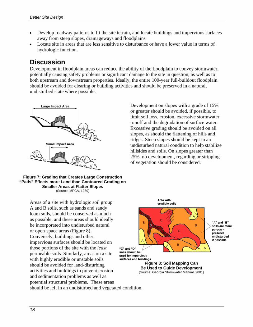
Development on slopes with a grade of 15% or greater should be avoided, if possible, to limit soil loss, erosion, excessive stormwater runoff and the degradation of surface water. Excessive grading should be avoided on all slopes, as should the flattening of hills and ridges. Steep slopes should be kept in an undisturbed natural condition to help stabilize hillsides and soils. On slopes greater than 25%, no development, regarding or stripping of vegetation should be considered.
Areas of a site with hydrologic soil group A and B soils, such as sands and sandy loam soils, should be conserved as much as possible, and these areas should ideally be incorporated into undisturbed natural or open-space areas (Figure 8). Conversely, buildings and other impervious surfaces should be located on those portions of the site with the least permeable soils. Similarly, areas on a site with highly erodible or unstable soils should be avoided for land-disturbing activities and buildings to prevent erosion and sedimentation problems as well as potential structural problems. These areas should be left in an undisturbed and vegetated condition.
Figure 7: Grading that Creates Large Construction “Pads” Effects more Land than Contoured Grading on
Smaller Areas at Flatter Slopes (Source: MPCA, 1989)
Large Impact Area
Small Impact Area
Figure 8: Soil Mapping Can Be Used to Guide Development
(Source: Georgia Stormwater Manual, 2001)
A
A
AA
B
B
B
C
C
C
D“A” and “B”soils are moreporous –preserveundisturbedif possible
“C” and “D”soils should beused for impervious surfaces and buildings
Area witherodible soils
A
A
AA
B
B
B
C
C
C
D“A” and “B”soils are moreporous –preserveundisturbedif possible
“C” and “D”soils should beused for impervious surfaces and buildings
Area witherodible soils

Better Site Design
19
The layout of roadways and buildings on a site should generally conform to the landforms on a site (Figure 9). Natural drainageways and stream buffer areas should be preserved by designing road layouts around them. Buildings should be sited to use the natural grading and drainage system and avoid the unnecessary disturbance of vegetation and soils. Roadway patterns on a site should be chosen to provide access schemes which match the terrain. In rolling or hilly terrain, streets should be designed to follow natural contours to reduce clearing and grading. In flatter areas, a traditional grid pattern of streets or "fluid" grids which bend and may be interrupted by natural drainageways may be more appropriate. In much the same way that a development should be designed to conform to the terrain of the site, layout should also be designed so that the areas of development are placed in the locations of the site that minimize the hydrologic impact of the project. This is accomplished by steering development to areas of the site that are less sensitive to land disturbance or have a lower value in terms of hydrologic function. Figure 10 shows a development site where the natural features have been mapped in order to delineate the hydrologically sensitive areas. Through careful site planning, sensitive areas can be set aside as natural open space areas. In many cases, such areas can be used as buffer spaces between land uses on the site or between adjacent sites. Additional Guidance
Figure 9: Preserving the Natural Topography of a Site (Source: Adapted from Prince George’s County, 1999)
Roads on ridge lines or upland areas
Vegetateddrainage swales
Natural drainagewayspreserved
Houses located on“brow” of ridge
Undisturbedvegetationon slopes
Roads on ridge lines or upland areas
Vegetateddrainage swales
Natural drainagewayspreserved
Houses located on“brow” of ridge
Undisturbedvegetationon slopes
Figure 10: Guiding Development to Less Sensitive Areas of a Site
(Source: Adapted from Prince George’s County, 1999)

Better Site Design
20
Arendt, Randall. 1996. Conservation Design for Subdivisions: A Practical Guide to Creating
Open Space Networks. American Planning Association. Chicago, IL. Available from the American Planning Association at www.planning.org
Environmental Protection Agency (EPA)
site on smart growth including a focus on community-based approaches to reducing sprawl. www.epa.gov/ebtpages/envismartgrowth.html Hart, Leslie. 1994. Guiding Principles of Sustainable Design. Prepared for the U.S Department
of the Interior and the National Parks Service. Available from http://www.nps.gov/dsc/dsgncnstr/gpsd/

Better Site Design
21
Better Site Design Practice #5: Preservation of Natural Features Open-Space Design and Conservation Design Description: Open-space site designs (also referred to as conservation development or clustering) incorporate smaller lot sizes to reduce overall impervious cover while providing more undisturbed open space and protection of water resources.
Key Benefits Typical Perceived Obstacles and Realities
• Preserves conservation areas on a development site
• Can be used to preserve natural hydrology and drainageways
• Can be used to help protect natural conservation areas and other site features
• Reduces the need for grading and land disturbance
• Reduces infrastructure needs and overall development costs
• Allows flexibility for developers to implement creative site designs, including better stormwater management practices
• Smaller lot sizes and compact development may be perceived by developers as less marketable – Open space designs are in fact highly desirable and have economic advantages such as cost savings and higher market appreciation
• Lack of speed and certainty in the review process may be of concern – Consult with the local review authority to review requirements; some communities are moving toward open- space design as a “by right” form of subdivision
• Prospective homebuyers may be reluctant to purchase homes due to concerns regarding management of the community open space – Proper methods and implementation of maintenance agreements are available; natural open space reduces maintenance costs and can help keep association fees down
• Open-space developments appear incompatible with adjacent land uses and are equated with increased noise and traffic – Open-space design allows preservation of natural areas, using less space for streets, sidewalks, parking lots and driveways; incorporating buffers into the design can help alleviate incompatibility with other competing land uses.
USING THIS PRACTICE • Use a site design which concentrates development and preserves open space and natural
areas of the site • Locate the developed portion of the cluster areas in the least sensitive areas of the site (see
practice #4). • Use reduced setbacks and frontages and narrower right-of-way widths to design non-
traditional lot layouts within the cluster.
Better Site Design
22
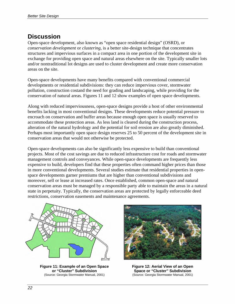
Discussion Open-space development, also known as “open space residential design” (OSRD), or conservation development or clustering, is a better site-design technique that concentrates structures and impervious surfaces in a compact area in one portion of the development site in exchange for providing open space and natural areas elsewhere on the site. Typically smaller lots and/or nontraditional lot designs are used to cluster development and create more conservation areas on the site. Open-space developments have many benefits compared with conventional commercial developments or residential subdivisions: they can reduce impervious cover, stormwater pollution, construction costand the need for grading and landscaping, while providing for the conservation of natural areas. Figures 11 and 12 show examples of open space developments. Along with reduced imperviousness, open-space designs provide a host of other environmental benefits lacking in most conventional designs. These developments reduce potential pressure to encroach on conservation and buffer areas because enough open space is usually reserved to accommodate these protection areas. As less land is cleared during the construction process, alteration of the natural hydrology and the potential for soil erosion are also greatly diminished. Perhaps most importantly open space design reserves 25 to 50 percent of the development site in conservation areas that would not otherwise be protected. Open-space developments can also be significantly less expensive to build than conventional projects. Most of the cost savings are due to reduced infrastructure cost for roads and stormwater management controls and conveyances. While open-space developments are frequently less expensive to build, developers find that these properties often command higher prices than those in more conventional developments. Several studies estimate that residential properties in open- space developments garner premiums that are higher than conventional subdivisions and moreover, sell or lease at increased rates. Once established, common open-space and natural conservation areas must be managed by a responsible party able to maintain the areas in a natural state in perpetuity. Typically, the conservation areas are protected by legally enforceable deed restrictions, conservation easements and maintenance agreements.
Figure 11: Example of an Open Space
or “Cluster” Subdivision (Source: Georgia Stormwater Manual, 2001)
Figure 12: Aerial View of an Open Space or “Cluster” Subdivision
(Source: Georgia Stormwater Manual, 2001)

Better Site Design
23
Flexible lot shapes and setback and frontage distances allow site designers to create attractive and unique lots that provide homeowners with enough space while allowing for the preservation of natural areas in a residential subdivision. A narrower right-of-way will consume less land that may be better used for housing lots and allow for a more compact site design. Figure 13 illustrates various nontraditional lot designs, and Figure 14 illustrates reduced front and side setbacks.
Additional Guidance Arendt, Randall. 1994. Designing Open Space Subdivisions: A Practical Step-by-Step Approach.
Natural Lands Trust, Inc. Media, PA. Available from www.natlands.org or www.greenerprospects.com
Figure 13: Nontraditional Lot Designs(Source: ULI, 1992)
Figure 14: Lots with Reduced Front and Side Setbacks (Source: Georgia Stormwater Manual, 2001)

Better Site Design
24
Arendt, Randall. 1996. Conservation Design for Subdivisions: A Practical Guide to Creating Open Space Networks. American Planning Association. Chicago, IL. Available from the American Planning Association at www.planning.org
Center for Watershed Protection. 1998. Better Site Design: A Handbook for Changing
Development Rules in Your Community. Available from www.cwp.org A non-profit Massachusetts organization dedicated to educating people about OSRD
development and implementation. http://www.greenneighborhoods.org/site/Index.htm University of Michigan study finds homebuyers want view of woods, not large lawns.
www.umich.edu/news/index.html?Releases/2004/Jun04/r062904a Environmental Protection Agency (EPA)
site on smart growth including a focus on community based approaches to reducing sprawl. www.epa.gov/ebtpages/envismartgrowth.html

Better Site Design
25
Better Site Design Practice #6: Roadway Reduction Reduction of Impervious Cover
Description: Roadway lengths and widths should be minimized on a development site where possible to reduce overall imperviousness.
Key Benefits Typical Perceived Obstacles and Realities
• Reduces the amount of impervious cover and associated runoff and pollutants generated
• Reduces the costs associated with road construction and maintenance
• Local codes may not permit shorter or narrower roads – Meet with local officials to discuss waivers for alternative designs that will address concerns of access, snow stockpiling, and parking.
• The public may view narrow roads as unsafe – Narrower roads in fact reduce the speeds at which vehicles drive; many maintenance and emergency vehicles can in fact access narrow roads
• Narrow and shorter roads do not have enough parking – Provisions can be made in the design of a site to accommodate off-street parking.
USING THIS PRACTICE • Consider different site and road layouts that reduce overall street length • Minimize street width by using narrower street designs that are a function of land use,
density and traffic demand. • Use smaller side-yard setbacks to reduce total road length. Discussion The use of alternative road layouts that reduce the total linear length of roadways can significantly reduce overall imperviousness of a development site. Site designers are encouraged to analyze different site and roadway layouts to see if they can reduce overall street length. In addition, residential streets and private streets within commercial and other development should be designed for the minimum required pavement width needed to support travel lanes, on-street parking and emergency access. Figure 15 shows options for narrower street designs. In many instances, on-street parking can be reduced to one lane or eliminated on local access roads with less than 200 average daily trips (ADT) and on short cul-de-sacs street. One-way, single-lane, loop roads are another way to reduce the width of lower-traffic streets. Further, reducing side yard setbacks and using narrower frontages can reduce total street length, which is especially important in cluster and open-space designs.

Better Site Design
26
Additional Guidance Arendt, Randall. 1994. Designing Open Space Subdivisions: A Practical Step-by-Step Approach.
Natural Lands Trust, Inc. Media, PA. Available from www.natlands.org or www.greenerprospects.com
Arendt, Randall. 1996. Conservation Design for Subdivisions: A Practical Guide to Creating
Open Space Networks. American Planning Association. Chicago, IL. Available from the American Planning Association at www.planning.org
Institute of Traffic Engineers (ITE). 2001. Residential Streets, Third Edition. Institute of Traffic
Engineers, Publication No. LP-630. Available from www.ite.org Institute of Traffic Engineers (ITE). 1999. Traditional Neighborhood Development Street Design
Guidelines. Institute of Traffic Engineers, Publication No. RP-027A. Available from www.ite.org
Institute of Traffic Engineers (ITE). 1997. Designing Neighborhood Streets. Institute of Traffic
Engineers, Publication No. VHS-027. Available from www.ite.org
Figure 15: Potential Design Options for Narrower Roadway Widths (Source: Georgia Stormwater Manual, 2001)
26’ PAVE WIDTH10’ DRAINAGE SWALE
4’ SIDEWALK3’ UTILITY
60’ RIGHT OF WAY
18’ PAVE WIDTH
6’ DRAINAGE SWALE
3’ UTILITY36’ RIGHT OF WAY

Better Site Design
27
Better Site Design Practice #7: Sidewalk Reduction Reduction of Impervious Cover Description: Sidewalk lengths and widths should be minimized on a development site where possible to reduce overall imperviousness.
Key Benefits Typical Perceived Obstacles and Realities
• Reduces the amount of impervious cover and associated runoff and pollutants generated
• Reduces the costs associated with construction and maintenance
• Reduces the individual homeowner’s responsibility for maintenance, such as snow clearance
• Sidewalks on only one side of the street may be perceived as unsafe – Accident research shows sidewalks on one side are nearly as safe as sidewalks on both
• Homebuyers are perceived to want sidewalks on both sides – Some actually prefer not to have a sidewalk in front of their home, and there is no market difference between homes with and without sidewalks directly in front.
• Local codes may not permit narrower, alternative, or the elimination of a sidewalk – Meet with local officials to discuss waivers for alternative designs that will address concerns of accessibility and safety issues.
USING THIS PRACTICE • Locate sidewalks on only one side of the street. • Provide common walkways linking pedestrian areas. • Use alternative sidewalk and walkway surfaces. • Shorten front setbacks to reduce walkway lengths. Discussion Most codes require that sidewalks be placed on both sides of residential streets (e.g., double sidewalks) and be constructed of impervious concrete or asphalt. Many subdivision codes also require sidewalks to be 4 to 6 feet wide and 2 to 10 feet from the street. These codes are enforced to provide sidewalks as a safety measure. Developers may wish to consider allowing sidewalks on only one side of the street or eliminating them where they don't make sense. Sidewalks should be designed with the goal of improving pedestrian movement and diverting it away from the street. Developers may also consider reducing sidewalk widths and placing them farther from the street. In addition, sidewalks should be graded to drain to front yards rather than the street. Alternative surfaces for sidewalks and walkways should be considered to reduce impervious cover (figures 16 and 17). In addition, building and home setbacks should be shortened to reduce the amount of impervious cover from entry walks.

Better Site Design
28
Additional Guidance Center for Watershed Protection. 1998. Better Site Design: A Handbook for Changing
Development Rules in Your Community. Available from www.cwp.org Website for Walkable Communities, Inc. www.walkablecommunities.org Litman, Todd Alexander. 2004. The Economic Value of Walkability. Victoria Transport Policy
Institute. Victoria, British Columbia. Available from http://www.vtpi.org/walkability.pdf
Figure 16: Sidewalk with a permeable paver surface
(Source: MA EOEA, 2005)
Figure 17: Sidewalk with Common Walkways Linking Pedestrian Areas
(Source: MA EOEA, 2005)

Better Site Design
29
Better Site Design Practice #8: Driveway Reduction Reduction of Impervious Cover Description: Where driveway lengths and widths should be minimized on a development site possible, to reduce overall imperviousness.
Key Benefits Typical Perceived Obstacles and Realities
• Reduces the amount of impervious
cover and associated runoff and pollutants generated
• Alternative driveway surfaces make snow removal more difficult – Careful site design, material selection and homeowner education can help alleviate the concern
• Developers perceive alternative surfaces as less marketable – “Green” development projects are increasingly being sought by consumers.
• Homeowners have concerns regarding access with shared driveways – Proper site design and homeowner education will alleviate access issues.
• Local codes may not permit shorter or narrower driveways or driveways with porous surfaces – Meet with local officials to discuss waivers for alternative designs.
USING THIS PRACTICE • Use shared driveways that connect two or more homes. • Use alternative driveway surfaces. • Use smaller lot front building setbacks to reduce total driveway length. Discussion Most local subdivision codes are not very explicit as to how driveways must be designed. Most simply require a standard apron to connect the street to the driveway but do not specify width or surface material for driveways. Typical residential driveways range from 12 feet wide for one-car driveways to 20 feet for two. Shared driveways are discouraged or prohibited by many communities. Shared driveways can reduce impervious cover and should be encouraged with enforceable maintenance agreements and easements. Secondly, the typical 400-800 square feet of impervious cover per driveway can be minimized by using narrower driveway widths, reducing the length of driveways, or using alternative surfaces such as double-tracks, reinforced grass or permeable paving materials.

Better Site Design
30
Building and home setbacks should be shortened to reduce the amount of impervious cover from driveways and entry walks. A setback of 20 feet is more than sufficient to allow a car to park in a driveway without encroaching into the public right of way and reduces driveway and walk pavement by more than 30 percent compared with a setback of 30 feet (see Figure 18).
Figure 18: Reduced Driveway and Walkway Lengths by Using Reduced Setbacks
(Adapted from: MPCA, 1989)
Typical 30 ftSetback
20 ftSetback
Reduction inImperviousSurfaces
Typical 30 ftSetback
20 ftSetback
Reduction inImperviousSurfaces
Figure 19: Reduced Driveway Lengths by Using Shared Driveways
(Source: MA EOEA, 2005)
Figure 20: Permeable Pavers as an Alternative Driveway Surface
(Source: MA EOEA, 2005)

Better Site Design
31
Additional Guidance Center for Watershed Protection. 1998. Better Site Design: A Handbook for Changing
Development Rules in Your Community. Available from www.cwp.org Prince George’s County, MD. June 1999. Low-Impact Development Design Strategies: An
Integrated Design Approach. Prince George’s County, Maryland, Department of Environmental Resources, Largo, Maryland. Available from www.epa.gov
Massachusetts Executive Office of Environmental Affairs (EOEA). 2005. Smart Growth Toolkit.
Boston, MA. Available from http://www.mass.gov/envir/

Better Site Design
32
Better Site Design Practice #9: Cul-de-sac Reduction Reduction of Impervious Cover Description: Minimize the number of cul-de-sacs and incorporate landscaped areas to reduce their impervious cover. The radius of a cul-de-sac should be the minimum required to accommodate emergency and maintenance vehicles. Alternative turnarounds should also be considered.
Key Benefits Typical Perceived Obstacles and Realities
• Reduces the amount of impervious cover, associated runoff and pollutants generated
• Increases aesthetics by allowing for natural or landscaped areas rather than pavement
• Emergency and maintenance vehicles require a large turning radius – Many newer vehicles are available with small turning radii.
• School buses require a large turning radius - Verify school bus pick-up plans. Not every cul-de-sac will need to accommodate school bus turning radii.
• Homeowners like the “end of the road” appeal of cul-de-sacs – This appeal can be accommodated using loop roads or lots that back onto open space areas.
• Local codes may not permit smaller or alternative cul-de-sac designs – Meet with local officials to discuss waivers for alternative designs that will address concerns of access.
USING THIS PRACTICE • Reduce the radius of the turnaround bulb or consider alternative cul-de-sac design, such as
“tee” turn-a-rounds or looping lanes. • Apply site design strategies that minimize dead-end streets. • Create a pervious island or a stormwater bioretention area in the middle of the cul-de-sac to
reduce impervious area. Discussion Alternative turnarounds are end of the street designs that replace fully-paved cul-de-sacs and reduce the amount of impervious cover created in developments. Cul-de-sacs are local access streets with a closed circular end that allows for vehicle turnarounds. Many of these cul-de-sacs can have a radius of more than 40 feet. From a stormwater perspective, cul-de-sacs create a huge bulb of impervious cover, increasing the amount of runoff. For this reason, reducing the size of cul-de-sacs through the use of alternative turnarounds or eliminating them altogether can reduce the amount of impervious cover created at a site.
Better Site Design
33
Numerous alternatives create less impervious cover than the traditional 40-foot cul-de-sac. These alternatives include reducing cul-de-sacs to a 30-foot radius and creating hammerheads, loop roads and pervious islands in the cul-de-sac center (see figures 21, 22 and 23 below). Sufficient turnaround area is a significant factor to consider in the design of cul-de-sacs. In particular, the types of vehicles entering the cul-de-sac should be considered. Firetrucks, service vehicles and schoolbuses are often cited as needing large turning radii. However, some firetrucks are designed for smaller turning radii. In addition, many newer largeservice vehicles are designed with a tri-axle (requiring a smaller turning radius), and many school buses usually do not enter individual cul-de-sacs. Another option for designing cul-de-sacs involves the placement of a pervious island in the center. Vehicles only travel along the outside of the cul-de-sac when turning, leaving an unused “island” of pavement in the center. These islands can be attractively landscaped and also designed as bioretention areas to treat stormwater (see practice #14).
40 ft cul-de sac withlandscaped island
30 ft radiuscul-de-sac
60 by 20 ft T-shapedturnaround
Loop road
40’30’
60’
20’
Figure 21: Turnaround Options for Residential Streets (Source: Adapted from Schueler, 1995)
Figure 23: T-Shaped Turnaround Option (Source: Center for Watershed Protection, 2005)
Figure 22: Loop Road Option (Source: Center for Watershed Protection, 2005)

Better Site Design
34
Additional Guidance Center for Watershed Protection. 1998. Better Site Design: A Handbook for Changing
Development Rules in Your Community. Available from www.cwp.org Schueler, T. 1995. Site Planning for Urban Stream Protection. Prepared for: Metropolitan
Washington Council of Governments. Washington, DC. Center for Watershed Protection, Ellicott City, MD. Available from www.cwp.org
Massachusetts Executive Office of Environmental Affairs (EOEA). 2005. Smart Growth Toolkit.
Boston, MA. Available from http://www.mass.gov/envir/

Better Site Design
35
Better Site Design Practice #10: Building Footprint Reduction Reduction of Impervious Cover Description: The impervious footprint of residences and commercial buildings can be reduced by using alternate or taller buildings while maintaining the same floor to area ratio.
Key Benefits Typical Perceived Obstacles and Realities
• Reduces the amount of impervious cover and associated runoff and pollutants generated
• Taller buildings are perceived to have higher construction and maintenance costs – Costs for taller buildings and associated parking may be offset by land costs.
• Local codes may not permit taller buildings – Consider alternative locations that do allow taller buildings, or meet with local officials to discuss waivers for alternative designs.
USING THIS PRACTICE • Use alternate or taller building designs to reduce the impervious footprint of buildings. • Consolidate functions and buildings or segment facilities to reduce footprints of structures. • Reduce directly connected impervious areas. Discussion In order to reduce the imperviousness associated with the footprint and rooftops of buildings and other structures, alternative and/or vertical (taller) building designs should be considered. Consolidate functions and buildings, as required, or segment facilities to reduce the footprint of individual structures. Figure 24 shows the reduction in impervious footprint by using a taller building design, and figures 25 and 26 show residential examples of reduced footprints.
Figure 24: Reduction of Impervious Cover by Building Up Rather than Out
(Source: Georgia Stormwater Manual, 2001)
Single Story Building
Four Story Building (75% Less
Impervious Cover)

Better Site Design
36
Additional Guidance Environmental Protection Agency (EPA)
site on smart growth including a focus on community based approaches to reducing sprawl. www.epa.gov/ebtpages/envismartgrowth.html
Hart, Leslie. 1994. Guiding Principles of Sustainable Design. Prepared for the U.S Department
of the Interior and the National Parks Service. Available from http://www.nps.gov/dsc/dsgncnstr/gpsd
Figure 26: Taller Apartments Create a Smaller Impervious Footprint
(Source: City of Portland, OR, 2001)
Figure 25: Taller Houses Create a Smaller Impervious Footprint
(Source: Center for Watershed Protection, 2005)
Better Site Design
37
Better Site Design Practice #11: Parking Reduction Reduction of Impervious Cover Description: Reduce the overall imperviousness associated with parking lots by eliminating unneeded spaces, providing compact car spaces, minimizing stall dimensions, incorporating efficient parking lanes, using multi-storied parking decks and using porous paver surfaces or porous concrete in overflow parking areas where feasible.
Key Benefits Typical Perceived Obstacles and Realities
• Reduces the amount of impervious cover, associated runoff and pollutants generated
• Reduces construction costs, long-term operation and maintenance costs, and the need for larger stormwater facilities
• Improves aesthetics of an area by increasing vegetative surfaces and reducing the feeling a large, paved urban area
• Developers desire excess parking and fear losing customers during peaks – The potential loss of customers due to reduced parking is unknown however, often times parking areas are not full during peak periods.
• Parking may spill over into residential or commercial areas when full – Include preferential parking provisions for residents or parking enforcement with meters.
• Trend to larger vehicles such as SUVs – Stall width requirements in most local parking codes are much larger than the widest SUVs.
• Structured parking is more expensive than surface lots – Costs for structured parking may be offset by land costs or by constructing garages above or below an actual building.
• Porous pavement surfaces are more expensive to install and maintain – Alternative surfaces may alleviate the need for larger stormwater treatment elsewhere on the site.
USING THIS PRACTICE • Reduce the number of unnecessary parking spaces by examining minimum parking ratio
requirements, and set a maximum number of spaces. • Reduce the number of un-needed parking spaces by examining the site’s accessibility to mass
transit. • Minimize individual parking stall dimensions. • Examine the traffic flow of the parking lot design to eliminate un-needed lanes / drive aisles • Consider parking structures and shared parking arrangements between non-competing uses • Use alternative porous surface for overflow areas or main parking areas if not a high-traffic
parking lot. • Use landscaping or vegetated stormwater practices in parking lot islands. • Provide incentives for compact and hybrid cars.

Better Site Design
38
Discussion Setting maximums for parking spaces, minimizing stall dimensions, using structured parking, encouraging shared parking and using alternative porous surfaces can all reduce the overall parking footprint and site imperviousness. Many parking lot designs result in far more spaces than actually required. This problem is exacerbated by a common practice of setting parking ratios to accommodate the highest hourly parking during the peak season. By determining average parking demand instead, a lower maximum number of parking spaces can be set to accommodate most of the demand. Table 4 provides examples of conventional parking requirements and compares them to average parking demand. In addition, the number of parking spaces needed may be reduced by a site’s accessibility to public transportation.
Table 4: Conventional Minimum Parking Ratios (Source: CWP, 1998) Parking Requirement
Land Use Parking Ratio Typical Range Actual Average
Parking Demand
Single family homes 2 spaces per dwelling unit 1.5–2.5 1.11 spaces per
dwelling unit
Shopping center 5 spaces per 1000 ft2 GFA 4.0–6.5 3.97 per 1000 ft2 GFA
Convenience store 3.3 spaces per 1000 ft2GFA 2.0–10.0 --
Industrial 1 space per 1000 ft2 GFA 0.5–2.0 1.48 per 1000 ft2 GFA
Medical/dental office 5.7 spaces per 1000 ft2GFA 4.5–10.0 4.11 per 1000 ft2 GFA
GFA = Gross floor area of a building without storage or utility spaces
Another technique to reduce the parking footprint is to minimize the dimensions of the parking spaces. This can be accomplished by reducing both the length and width of the parking stall. Parking stall dimensions can be further reduced if compact spaces are provided. Another method to reduce the parking area is to incorporate efficient parking lanes such as using one-way drive aisles with angled parking rather than the traditional two-way aisles. Structured parking decks are another method for significantly reducing the overall parking footprint by minimizing surface parking. Figure 27 shows a parking deck used for a commercial development. Shared parking in mixed-use areas and structured parking are techniques that can further reduce the conversion of land to impervious cover. A shared parking arrangement could include usage of the same parking lot by an office space that experiences peak parking demand during the weekday with a church that experiences parking demands during the weekends and evenings.
Figure 27: Structured Parking at an Office Park
(Source: Georgia Stormwater Manual, 2001)
Better Site Design
39
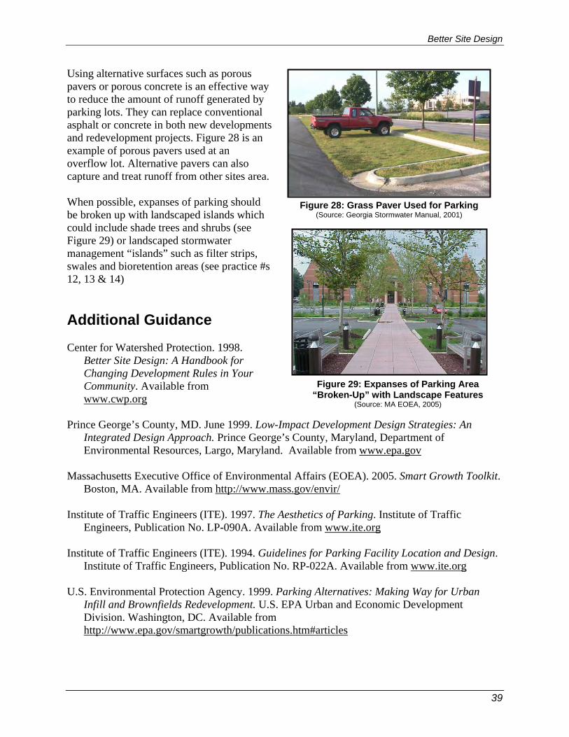
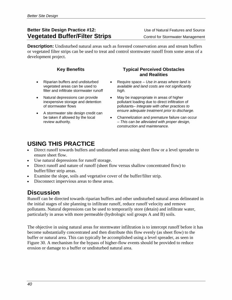
Using alternative surfaces such as porous pavers or porous concrete is an effective way to reduce the amount of runoff generated by parking lots. They can replace conventional asphalt or concrete in both new developments and redevelopment projects. Figure 28 is an example of porous pavers used at an overflow lot. Alternative pavers can also capture and treat runoff from other sites area. When possible, expanses of parking should be broken up with landscaped islands which could include shade trees and shrubs (see Figure 29) or landscaped stormwater management “islands” such as filter strips, swales and bioretention areas (see practice #s 12, 13 & 14) Additional Guidance Center for Watershed Protection. 1998.
Better Site Design: A Handbook for Changing Development Rules in Your Community. Available from www.cwp.org
Prince George’s County, MD. June 1999. Low-Impact Development Design Strategies: An
Integrated Design Approach. Prince George’s County, Maryland, Department of Environmental Resources, Largo, Maryland. Available from www.epa.gov
Massachusetts Executive Office of Environmental Affairs (EOEA). 2005. Smart Growth Toolkit.
Boston, MA. Available from http://www.mass.gov/envir/ Institute of Traffic Engineers (ITE). 1997. The Aesthetics of Parking. Institute of Traffic
Engineers, Publication No. LP-090A. Available from www.ite.org Institute of Traffic Engineers (ITE). 1994. Guidelines for Parking Facility Location and Design.
Institute of Traffic Engineers, Publication No. RP-022A. Available from www.ite.org U.S. Environmental Protection Agency. 1999. Parking Alternatives: Making Way for Urban
Infill and Brownfields Redevelopment. U.S. EPA Urban and Economic Development Division. Washington, DC. Available from http://www.epa.gov/smartgrowth/publications.htm#articles
Figure 28: Grass Paver Used for Parking (Source: Georgia Stormwater Manual, 2001)
Figure 29: Expanses of Parking Area “Broken-Up” with Landscape Features
(Source: MA EOEA, 2005)
Better Site Design
40
Better Site Design Practice #12: Use of Natural Features and Source Vegetated Buffer/Filter Strips Control for Stormwater Management Description: Undisturbed natural areas such as forested conservation areas and stream buffers or vegetated filter strips can be used to treat and control stormwater runoff from some areas of a development project.
Key Benefits Typical Perceived Obstacles
and Realities • Riparian buffers and undisturbed
vegetated areas can be used to filter and infiltrate stormwater runoff
• Natural depressions can provide inexpensive storage and detention of stormwater flows
• A stormwater site design credit can be taken if allowed by the local review authority.
• Require space – Use in areas where land is available and land costs are not significantly high.
• May be inappropriate in areas of higher pollutant loading due to direct infiltration of pollutants– Integrate with other practices to ensure adequate treatment prior to discharge.
• Channelization and premature failure can occur – This can be alleviated with proper design, construction and maintenance.
USING THIS PRACTICE • Direct runoff towards buffers and undisturbed areas using sheet flow or a level spreader to
ensure sheet flow. • Use natural depressions for runoff storage. • Direct runoff and nature of runoff (sheet flow versus shallow concentrated flow) to
buffer/filter strip areas. • Examine the slope, soils and vegetative cover of the buffer/filter strip. • Disconnect impervious areas to these areas. Discussion Runoff can be directed towards riparian buffers and other undisturbed natural areas delineated in the initial stages of site planning to infiltrate runoff, reduce runoff velocity and remove pollutants. Natural depressions can be used to temporarily store (detain) and infiltrate water, particularly in areas with more permeable (hydrologic soil groups A and B) soils.
The objective in using natural areas for stormwater infiltration is to intercept runoff before it has become substantially concentrated and then distribute this flow evenly (as sheet flow) to the buffer or natural area. This can typically be accomplished using a level spreader, as seen in Figure 30. A mechanism for the bypass of higher-flow events should be provided to reduce erosion or damage to a buffer or undisturbed natural area.

Better Site Design
41
Carefully constructed berms can be placed around natural depressions and below undisturbed vegetated areas with porous soils to provide for additional runoff storage and/or infiltration of flows.
Additional Guidance Center for Watershed Protection. 1998. Better Site Design: A Handbook for Changing
Development Rules in Your Community. Available from www.cwp.org Prince George’s County, MD. June 1999. Low-Impact Development Design Strategies: An
Integrated Design Approach. Prince George’s County, Maryland, Department of Environmental Resources, Largo, Maryland. Available from www.epa.gov
Figure 30: Use of a Level Spreader with a Riparian Buffer (Source: Georgia Stormwater Manual, 2001)
LEVELSPREADER
UNDISTURBEDBUFFER
Figure 32: Use of a Vegetated Filter Strip
(Source: MA EOEA, 2005)
Figure 31: Use of a Grassed Filter Strip (Source: MA EOEA, 2005)

Better Site Design
42
City of Portland, Oregon. September 2004. Stormwater Management Manual. Bureau of Environmental Services, Portland, OR. Available from http://www.portlandonline.com/bes/

Better Site Design
43
Better Site Design Practice #13: Use of Natural Features and Source Open Vegetated Channels Control for Stormwater Management
Description: The natural drainage paths of a site, or properly designed and constructed vegetated channels can be used instead of constructing underground storm sewers or concrete open channels. Where density, topography, soils, slope and safety issues permit, vegetated open channels can be used in the street right-of-way to convey and treat stormwater runoff from roadways.
Key Benefits Typical Perceived Obstacles and Realities
• Reduces the cost of road and storm sewer construction
• Provides for some runoff storage and infiltration, as well as treatment of stormwater
• A stormwater site design credit can be taken if allowed by the local review authority.
• Increases stormwater travel times and lowers peak discharges.
• Local codes may not allow swales instead of curb and gutter or closed drainage pipes – Meet with local officials to discuss waivers for alternative designs.
• There is a strong perception that swales require more maintenance than curb and gutter or closed drainage pipes – With the proper design, swales require less maintenance and are less prone to failure.
• Lack of curbing may increase potential for failure of the pavement at the grass interface – The potential for failure can be alleviated by hardening the interface by installing grass pavers, geosynthetics or placing a low-rising concrete strip along the pavement edge.
USING THIS PRACTICE • Preserve natural flow paths in the site design. • Direct runoff to natural drainage ways, ensuring that peak flows and velocities will not cause
channel erosion. • Use vegetated open channels (enhanced wet or dry swales or grass channels) and pipes in
place of curb and gutter, to convey and treat stormwater runoff. • Ensure runoff volumes and velocities provide adequate residence times and non-erosive
conditions (i.e., use of check dams). Discussion Open vegetated channels (see figures 33 and 34) remove pollutants by allowing infiltration and filtration to occur, unlike curb-and-gutter systems or closed piping systems which move water with virtually no treatment. Curb-and-gutter and storm drain systems allow for the quick transport of stormwater, which results in increased peak flow and flood volumes and reduced runoff infiltration. Curb-and-gutter systems also do not provide treatment of stormwater that is often polluted from vehicle emissions, pet waste, lawn runoff and litter. Engineering techniques have advanced the roadside ditches of the past, which suffered from erosion, standing water and

Better Site Design
44
breakup of the road edge. Grass channels and enhanced dry swales are two such alternatives, and with proper installation under the right site conditions, they are excellent methods for treating stormwater on site. In addition, open vegetated channels can be less expensive to install than curb-and-gutter systems. Complete descriptions and design criteria for open channels are included in the New York State Stormwater Management Manual.
Figure 33: Examples of Open Vegetated Channels (Source: Georgia Stormwater Manual, 2001)
Figure 34: Another Example of an Open Vegetated Channel
(Source: MA EOEA, 2005)

Better Site Design
45
Additional Guidance Center for Watershed Protection. 1998. Better Site Design: A Handbook for Changing
Development Rules in Your Community. Available from www.cwp.org Center for Watershed Protection. August 2003. New York State Stormwater Management Design
Manual. Prepared for New York State Department of Environmental Conservation, Albany, NY. http://www.dec.state.ny.us/website/dow/toolbox/swmanual/#Downloads
Prince George’s County, MD. June 1999. Low-Impact Development Design Strategies: An
Integrated Design Approach. Prince George’s County, Maryland, Department of Environmental Resources, Largo, Maryland. Available from www.epa.gov
City of Portland, Oregon. September 2004. Stormwater Management Manual. Bureau of
Environmental Services, Portland, OR. Available from http://www.portlandonline.com/bes/ Massachusetts Executive Office of Environmental Affairs (EOEA). 2005. Smart Growth Toolkit.
Boston, MA. Available from http://www.mass.gov/envir/

Better Site Design
46
Better Site Design Practice #14: Use of Natural Features and Source Bioretention and Rain Gardens Control for Stormwater Management Description: Provide stormwater treatment for runoff from impervious surfaces using bioretention areas or rain gardens that can be integrated into required landscaping areas and traffic islands.
Key Benefits Typical Perceived Obstacles and Realities
• Breaks up impervious cover, thus allowing for better infiltration and treatment from smaller drainage areas.
• Combines landscaping with stormwater treatment.
• Improves aesthetics.
• Reduces thermal impacts.
• Bioretention areas require regular maintenance – Regular maintenance amounts to general landscaping duties such as trash removal, mulching, weeding and irrigation.
• Bioretention areas may be expensive – Using bioretention and other on-site treatment can significantly reduce the need for storm drain,s thus reducing stormwater infrastructure costs
USING THIS PRACTICE • Integrate bioretention into a parking lot or roadway design. • Integrate bioretention, or raingardens, into on-lot residential designs. • Closely examine runoff volumes and velocities to ensure runoff enters bioretention in a
distributed manner and in a non-erosive condition. • Ensure the bioretention has proper pre-treatment. • Carefully select the landscaping materials required. • Use as a retrofit or in redevelopment projects. Discussion Bioretention areas are naturally vegetated, structural, stormwater-treatment practices that offer an aesthetically pleasing alternative to pavement or traditional detention stormwater facilities. Bioretention areas resemble landscaped depressions and can contain grasses, wildflowers or trees, depending on the size of the facility. Stormwater runoff is routed by slopes, curb cuts or piping into these depressions, where it is allowed to pond temporarily. Eventually, the retained runoff will seep through an organic underground filter system before discharging to an underdrain or infiltrating to the underlying soils. Treatment of stormwater includes attenuation of sediment, metals, bacteria and nutrients. Complete descriptions and design criteria for bioretention are included in the New York State Stormwater Management Manual (http://www.dec.state.ny.us/website/dow/toolbox/swmanual/#Downloads) Bioretention facilities can receive runoff from areas as small as residential lawns or as large as commercial parking areas. These facilities are often used to replace conventional landscaping in parking areas or along roadways. Site limitations include steep slopes, high water tables or

Better Site Design
47
excessively cold climates. Where unusually high sediment loading is expected, proper pretreatment, such as a sediment forebay designed for settling sediments, should be used to reduce the probability of clogging the subsurface filter.
Parking lots should be designed with landscaped stormwater management “islands” which reduce the connected impervious cover of the lot as well as provide for runoff treatment and control in stormwater facilities. Bioretention can be incorporated into roadway design as well, such as in the center of a cul-de-sac or within roadway rights-of-way or easements following sheet flow from the road surface.
Rain gardens are smaller versions of bioretention, typically considered for on-lot residential designs. Rain gardens can be landscaped depressions on the lot used to mitigate rooftop runoff, or can be designed as the low point of a lot to treat on-site stormwater. Rain gardens are constructed as shallow depressions where stormwater runoff will collect during and shortly after a rain event. These areas are vegetated with plants that are both aesthetically pleasing and well suited to an environment periodically inundated with water. Rain gardens can be designed at different scales to suit different levels of runoff. Adequate sizing of these gardens will allow for infiltration of the most common rain events, while runoff from larger events will overflow into other stormwater infrastructure or a receiving water body. Rain gardens are an appropriate practice as long as certain potential site constraints have been considered. Drainage areas cannot be too extensive for rain gardens, and slopes leading to them cannot be too steep because large volumes of rain or runoff moving at excessive velocities will simply overwhelm these facilities. Also, where subsurface soils do not naturally allow for good drainage, these soils should be replaced or mixed with sandier varieties.
Figure 36: Example of a Bioretention Facility Along Roadway
Figure 35: Example of a Bioretention Facility in a Parking Lot Island

Better Site Design
48
Additional Guidance Center for Watershed Protection. August 2003. New York State Stormwater Management Design
Manual. Prepared for New York State Department of Environmental Conservation, Albany, NY. http://www.dec.state.ny.us/website/dow/toolbox/swmanual/#Downloads
Prince George’s County, MD. June 1999. Low-Impact Development Design Strategies: An
Integrated Design Approach. Prince George’s County, Maryland, Department of Environmental Resources, Largo, Maryland. Available from www.epa.gov
City of Portland, Oregon. September 2004. Stormwater Management Manual. Bureau of
Environmental Services, Portland, OR. Available from http://www.portlandonline.com/bes/ Massachusetts Executive Office of Environmental Affairs (EOEA). 2005. Smart Growth Toolkit.
Boston, MA. Available from http://www.mass.gov/envir/ Low Impact Development (LID) Center website: http://www.lowimpactdevelopment.org/
Figure 37: Example of an On-Lot Rain Garden Source (MA EOEA, 2005)
Better Site Design
49
Better Site Design Practice #15: Use of Natural Features and Source Infiltration Control for Stormwater Management Description: Use infiltration trenches, basins or leaching chambers to provide groundwater recharge, mimic existing hydrologic conditions and reduce runoff and pollutant export. Permeable paving surfaces may also be used where site conditions are appropriate.
Key Benefits Typical Perceived Obstacles and Realities
• Increases recharge to the groundwater.
• Reduces stormwater runoff volume and peak runoff rates; therefore, pipes and basins are smaller.
• Can increase effective developable area on a site because portions of the stormwater system are located underneath the paved areas.
• Grass pavers can improve site appearance by providing vegetation where there would otherwise be only pavement.
• Infiltration trenches and dry wells cannot receive untreated stormwater runoff, except rooftop runoff – Provide proper pretreatment such as grass swales or filter strip.
• Rehabilitation of failed infiltration trenches and dry wells requires complete reconstruction – Proper system design, construction and ongoing operation and maintenance will prevent failure.
• Permeable paving can be prone to clogging from sand and fine sediments that fill void spaces and the joints between pavers – Avoid permeable paving in high traffic areas where frequent winter sanding is necessary; provide periodic maintenance.
• Snow plows can catch the edge of grass pavers and some paving stones – Avoid using in high traffic areas; and attach rollers to the bottom edge of a snowplow to prevent this problem.
USING THIS PRACTICE • May be used for roadway or parking impervious areas if adequate pre-treatment is.
provided;Rooftop runoff may discharge directly to drywells or infiltration chambers. • The site must have soils with moderate to high infiltration capacities and must have adequate
depth to groundwater. • Certain sites (i.e., pollutant hotspots) require additional pretreatment prior to infiltration. • Use porous pavers only in low-traffic areas or for pedestrian walkways/plazas. • Poor soils may preclude aggressive infiltration.
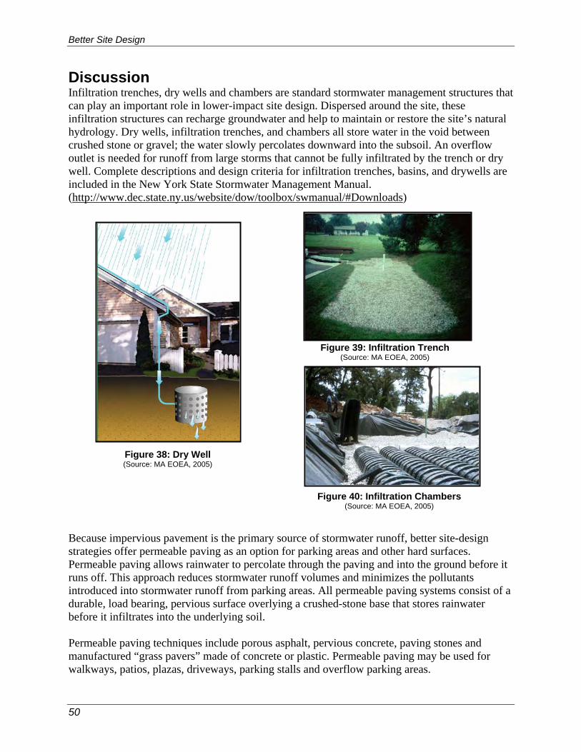
Better Site Design
50
Discussion Infiltration trenches, dry wells and chambers are standard stormwater management structures that can play an important role in lower-impact site design. Dispersed around the site, these infiltration structures can recharge groundwater and help to maintain or restore the site’s natural hydrology. Dry wells, infiltration trenches, and chambers all store water in the void between crushed stone or gravel; the water slowly percolates downward into the subsoil. An overflow outlet is needed for runoff from large storms that cannot be fully infiltrated by the trench or dry well. Complete descriptions and design criteria for infiltration trenches, basins, and drywells are included in the New York State Stormwater Management Manual. (http://www.dec.state.ny.us/website/dow/toolbox/swmanual/#Downloads) Because impervious pavement is the primary source of stormwater runoff, better site-design strategies offer permeable paving as an option for parking areas and other hard surfaces. Permeable paving allows rainwater to percolate through the paving and into the ground before it runs off. This approach reduces stormwater runoff volumes and minimizes the pollutants introduced into stormwater runoff from parking areas. All permeable paving systems consist of a durable, load bearing, pervious surface overlying a crushed-stone base that stores rainwater before it infiltrates into the underlying soil. Permeable paving techniques include porous asphalt, pervious concrete, paving stones and manufactured “grass pavers” made of concrete or plastic. Permeable paving may be used for walkways, patios, plazas, driveways, parking stalls and overflow parking areas.
Figure 38: Dry Well (Source: MA EOEA, 2005)
Figure 40: Infiltration Chambers (Source: MA EOEA, 2005)
Figure 39: Infiltration Trench (Source: MA EOEA, 2005)
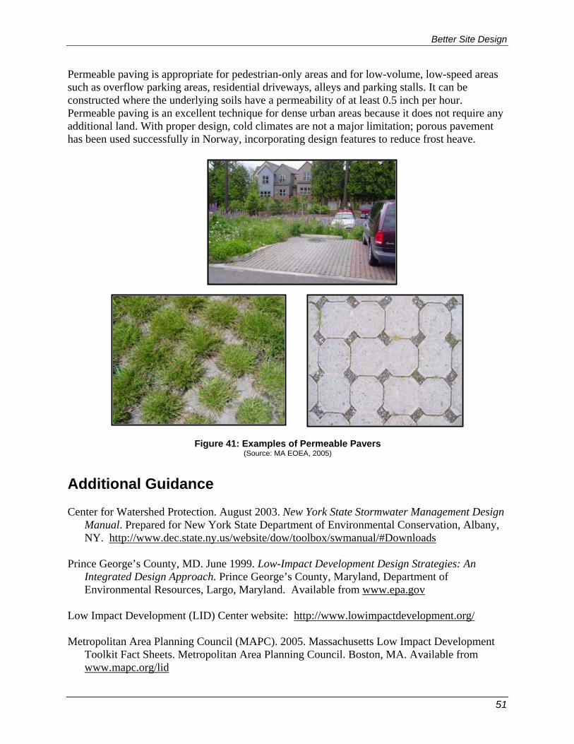
Better Site Design
51
Permeable paving is appropriate for pedestrian-only areas and for low-volume, low-speed areas such as overflow parking areas, residential driveways, alleys and parking stalls. It can be constructed where the underlying soils have a permeability of at least 0.5 inch per hour. Permeable paving is an excellent technique for dense urban areas because it does not require any additional land. With proper design, cold climates are not a major limitation; porous pavement has been used successfully in Norway, incorporating design features to reduce frost heave.
Additional Guidance Center for Watershed Protection. August 2003. New York State Stormwater Management Design
Manual. Prepared for New York State Department of Environmental Conservation, Albany, NY. http://www.dec.state.ny.us/website/dow/toolbox/swmanual/#Downloads
Prince George’s County, MD. June 1999. Low-Impact Development Design Strategies: An
Integrated Design Approach. Prince George’s County, Maryland, Department of Environmental Resources, Largo, Maryland. Available from www.epa.gov
Low Impact Development (LID) Center website: http://www.lowimpactdevelopment.org/ Metropolitan Area Planning Council (MAPC). 2005. Massachusetts Low Impact Development
Toolkit Fact Sheets. Metropolitan Area Planning Council. Boston, MA. Available from www.mapc.org/lid
Figure 41: Examples of Permeable Pavers (Source: MA EOEA, 2005)

Better Site Design
52
Better Site Design Practice #16: Use of Natural Features and Source Rooftop Runoff Reduction Mitigation Control for Stormwater Management Description: Direct runoff from residential rooftop areas to pervious areas, lower-impact practices or use “green-roof” (specially designed vegetated rooftops) strategies to reduce rooftop runoff volumes and rates.
Key Benefits Typical Perceived Obstacles and Realities
• Sending runoff to pervious areas, lower-impact practices or using green roofs increases overland flow time and reduces peak flows.
• Vegetated and pervious areas can filter and infiltrate stormwater runoff, thus increasing water quality.
• A stormwater site design credit can be taken if allowed by the local review authority.
• Wet basements will result from re-directing rooftop runoff – Careful design and construction inspection will minimize this condition.
• Re-directed rooftop runoff may increase a property owner’s maintenance burden – When designed properly, on-lot rain gardens do not require supplemental water.
• Alternative rooftop runoff mitigation may be costly – Rain barrels, in fact, are inexpensive and will reduce water-use costs; green roofs reduce heating and cooling costs and roof replacement costs.
USING THIS PRACTICE • Direct rooftop runoff to pervious areas such as yards, open channels or vegetated areas. • Direct rooftop runoff to lower-impact practices such as rain barrels, cisterns, drywells, rain
gardens, or stormwater planters. • Use “green roofs” to reduce stormwater runoff from rooftops. Discussion Stormwater quantity and quality benefits can be achieved by routing the runoff from rooftop areas to pervious areas such as lawns, landscaping, filter strips and vegetated channels. Much like the use of undisturbed buffers and natural areas (see practices #1 & 2), revegetated areas such as lawns and engineered filter strips and vegetated channels can act as biofilters for stormwater runoff and provide for infiltration in more permeable soils (hydrologic groups A and B).
Cisterns and rain barrels are designed to retain water that runs off of roofs for an extended period. Rain barrels are smaller structures ranging generally from 20 to 100 gallons, while cisterns can store thousands of gallons, depending on the design. Construction material for rain barrels is generally plastic although other materials such as wooden barrels have been used. Cisterns can be constructed of metal, wood, concrete or plastic. Stormwater stored in these structures is generally used for irrigation,

Better Site Design
53
although more complex designs incorporate that water into everyday uses such as toilet and shower water. Rain barrels and cisterns have historically been used in more arid climates where water is scarce for much of the year. More recently, however, these technologies have been applied in less arid climates because of the savings in water costs and overall increases in water demands.
Drywells, as described under practice #15, are underground chambers surrounded by crushed stone, typically used to infiltrate runoff from rooftops. Drywells are well suited for residential applications or small buildings.
Rain gardens, as described under practice #14, are constructed as shallow depressions where stormwater runoff will collect during and shortly after a rain event. These areas are vegetated with plantings that are both aesthetically pleasing and well suited to an environment periodically inundated with water. Rain gardens are well suited for small drainage areas such as residential building rooftops.
Stormwater planters are a small-scale engineered management strategy designed to treat limited volumes of stormwater runoff in discrete areas. Planters generally look like large vaulted plant boxes and can contain anything from basic wildflower communities to complex arrangements of trees and flowering shrubs. Other stormwater planters, known as “tree boxes,” are simply modified side tree enclosures that are installed below the surface of the sidewalk. Stormwater is generally routed into these systems from roofs via downspouts, where it runs through various filtering media and is also subject to uptake from vegetation. Because of the compact and self-contained nature of these practices, they are best suited to handling rooftop runoff. Multiple units can be used to treat large-scale commercial developments.
Green rooftops are rooftop areas that have been landscaped with grasses, shrubs and, in some cases, trees. “Intensive” rooftops are designed with pedestrian access and deep soil layers to provide for complex planting schemes. “Extensive” rooftops are designed with a more shallow soil foundation and generally do not incorporate pedestrian access. Stormwater runoff is either retained until uptake can occur, or eventually runs off the roof with considerably less pollution than would be contained in runoff from a standard impervious rooftop. Beyond stormwater pretreatment, benefits of green rooftops include reduction of the “heat island” effect, extended life of the rooftop, aesthetic appeal and increased useable area. Green rooftops are best suited for
Figure 42: Rain Barrel (Source: MA EOEA, 2005)
Figure 43: Stormwater Planters (Source: MA EOEA, 2005)

Better Site Design
54
the construction of new buildings because the special structural considerations necessary for these applications can be incorporated early in the design phase. Retrofits to older buildings are often possible, however, owing to the fact that the rooftops were designed well beyond the minimum necessary support capacity.
Additional Guidance Prince George’s County, MD. June 1999. Low-
Impact Development Design Strategies: An Integrated Design Approach. Prince George’s County, Maryland, Department of Environmental Resources, Largo, Maryland. Available from www.epa.gov
Rhode Island Department of Environmental Management. January 2005. The Urban
Environmental Design Manual. Rhode Island Department of Environmental Management, Providence, Rhode Island. Available from http://www.dem.state.ri.us/programs/bpoladm/suswshed/pubs.htm
City of Portland, Oregon. September 2004. Stormwater Management Manual. Bureau of
Environmental Services, Portland, OR. Available from http://www.portlandonline.com/bes/ Green Roofs for Healthy Cities website - www.greenroofs.org The international greenroof industry’s resource and online information portal.
www.greenroofs.com
Figure 44: Green Roof (Source: MA EOEA, 2005)

Better Site Design
55
Better Site Design Practice #17: Stream Daylighting for Utilization of Natural Features and Source Redevelopment Projects Control for Stormwater Management Description: Stream Daylight previously-culverted/piped streams to restore natural habitats, better attenuate runoff and help reduce pollutant loads where feasible and practical.
Key Benefits Typical Perceived Obstacles and Realities
• The aesthetic appeal of daylighted streams can be expected to add appeal to neighborhoods or urban areas.
• Improves water quality.
• Prevents flooding by increasing storage and reducing peak flows.
• Increases habitat and wildlife value.
• Increases pedestrian traffic and general public use.
• Increases property values.
• Daylighting a stream can be expensive - Costs for daylighting streams are often comparable to costs for replacing culverts.
• Maintenance of daylighted stream areas can be intensive during the first years the stream is established – Once the banks are well established, regular maintenance is similar to that required in any public green spac,e such as trash removal, mowing and general housekeeping.
• Finding the original stream channel may be difficult – examine historic records, soils, and up and downstream channel characteristics.
• Political backing and public support is more difficult for daylighting streams than for surface restoration because the culvert is not seen – Provide proper public education and outreach about the benefits and how safety issues will be addressed.
USING THIS PRACTICE • Daylighting should be considered when a culvert replacement is scheduled. • Restore historic drainage patterns by removing closed drainage systems and constructing
stabilized, vegetated streams. • Carefully examine flooding potential, utility impacts and/or prior contaminated sites. • Consider runoff pretreatment and erosion potential of restored streams/rivers. Discussion Stream daylighting involves uncovering a stream or a section of a stream that had been artificially enclosed in the past to accommodate development. The original enclosure of rivers and streams often took place in urbanized areas through the use of large culvert operations that often integrated the stormsewer system and combined sanitary sewers. The daylighting operation, therefore, often requires overhauls or updating of storm-drain systems and re-
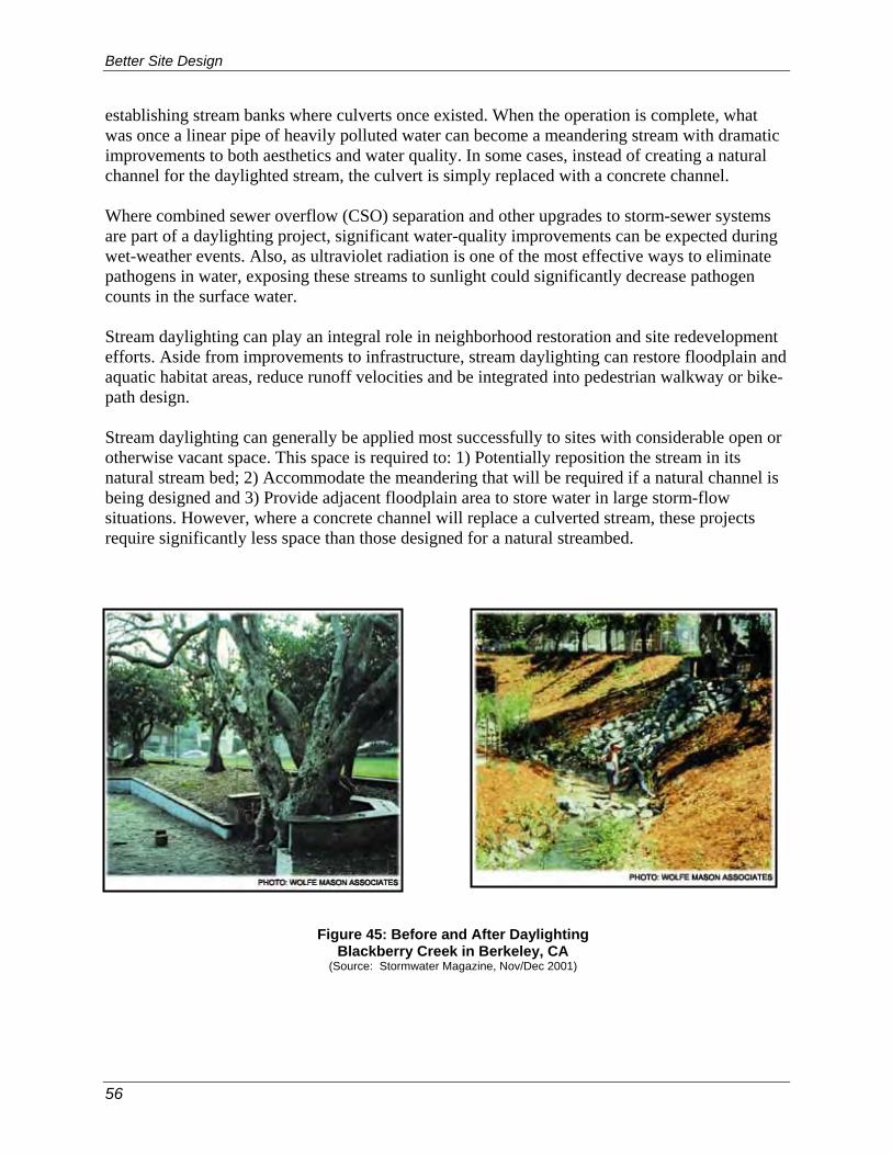
Better Site Design
56
establishing stream banks where culverts once existed. When the operation is complete, what was once a linear pipe of heavily polluted water can become a meandering stream with dramatic improvements to both aesthetics and water quality. In some cases, instead of creating a natural channel for the daylighted stream, the culvert is simply replaced with a concrete channel. Where combined sewer overflow (CSO) separation and other upgrades to storm-sewer systems are part of a daylighting project, significant water-quality improvements can be expected during wet-weather events. Also, as ultraviolet radiation is one of the most effective ways to eliminate pathogens in water, exposing these streams to sunlight could significantly decrease pathogen counts in the surface water. Stream daylighting can play an integral role in neighborhood restoration and site redevelopment efforts. Aside from improvements to infrastructure, stream daylighting can restore floodplain and aquatic habitat areas, reduce runoff velocities and be integrated into pedestrian walkway or bike- path design. Stream daylighting can generally be applied most successfully to sites with considerable open or otherwise vacant space. This space is required to: 1) Potentially reposition the stream in its natural stream bed; 2) Accommodate the meandering that will be required if a natural channel is being designed and 3) Provide adjacent floodplain area to store water in large storm-flow situations. However, where a concrete channel will replace a culverted stream, these projects require significantly less space than those designed for a natural streambed.
Figure 45: Before and After Daylighting Blackberry Creek in Berkeley, CA
(Source: Stormwater Magazine, Nov/Dec 2001)
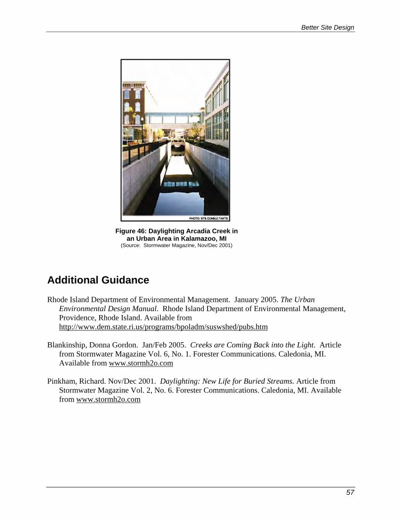
Better Site Design
57
Additional Guidance Rhode Island Department of Environmental Management. January 2005. The Urban
Environmental Design Manual. Rhode Island Department of Environmental Management, Providence, Rhode Island. Available from http://www.dem.state.ri.us/programs/bpoladm/suswshed/pubs.htm
Blankinship, Donna Gordon. Jan/Feb 2005. Creeks are Coming Back into the Light. Article
from Stormwater Magazine Vol. 6, No. 1. Forester Communications. Caledonia, MI. Available from www.stormh2o.com
Pinkham, Richard. Nov/Dec 2001. Daylighting: New Life for Buried Streams. Article from
Stormwater Magazine Vol. 2, No. 6. Forester Communications. Caledonia, MI. Available from www.stormh2o.com
Figure 46: Daylighting Arcadia Creek in an Urban Area in Kalamazoo, MI
(Source: Stormwater Magazine, Nov/Dec 2001)
Better Site Design
58
Better Site Design Practice #18: Tree Planting Description: Plant or conserve trees at new or redevelopment sites to reduce stormwater runoff, increase nutrient uptake, provide bank stabilization, provide shading and provide wildlife habitat. Trees can be used for applications such as landscaping, stormwater management practice areas, conservation areas and erosion and sediment control.
Key Benefits Typical Perceived Obstacles and Realities
• Reduces construction and maintenance costs.
• Increases property values.
• Reduces urban heat island, decreases heating and cooling costs, blocks UV radiation.
• Buffers wind and noise.
• Planting trees in stormwater management practices can increase nutrient uptake, reduce runoff through rainfall interception and evapotranspiration (ET), aid infiltration, provide wildlife habitat, provide shading, discourage geese and reduce mowing costs.
• Tree planting can be applied to stormwater credit #6, “Riparian Reforestation.”
• Local codes may restrict trees in certain areas – Consult with local officials to discuss waivers for alternative designs.
• Trees may not survive through construction or in certain urban environments – Trees will survive with proper tree selection, landscape design and protection during construction.
• Planting or preserving trees may be expensive – Conserving or planting trees increases property values.
• Native vegetation may harbor undesirable wildlife and insects - Most people enjoy viewing wildlife; native vegetation does not provide a food source for most vermin; continued education is necessary to show that humans and wildlife can co-exist, even at the neighborhood level.
USING THIS PRACTICE • Conserve existing trees during construction by performing an inventory of the existing forest
and identifying trees to protect. • Design the development with tree conservation in mind, protect trees during construction and
protect trees after construction. • Plant trees at development sites by first selecting the planting sites and then evaluate and
improve the planting sites. Trees should be planted in stormwater-management practices and other open spaces.
• Tree types and locations should be chosen to withstand the constraints of an urban setting.

Better Site Design
59
Discussion Few communities require that trees and native vegetation be conserved during the development process. However, native trees, shrubs, and grasses are important contributors to the overall quality and viability of the environment. Some tools that can be used for tree conservation include open space development practices, planting of vegetation in street, clearing and grading restrictions that include preservation of trees and native vegetation and the addition of vegetation to parking-lot islands. Developers, engineers or landscape architects can incorporate more trees into a development site, using a three-prong approach: Conserving existing trees during construction; planting trees in stormwater management practices; and Planting trees in other open spaces.
Trees can be conserved and planted at both new development and redevelopment or infill projects. On currently forested development sites, it is most important to conserve existing trees, particularly high-quality stands or large, mature trees (Figure 47). To conserve existing trees, developers should inventory existing forest at the site to identify the best trees and forest to protect, design the development around these trees and take measures to ensure the protection of trees both during and after construction.
Where tree conservation is not an option, urban development sites provide many opportunities to plant new trees, such as in stormwater management practices (SMPs) and other pervious areas of the site. Some SMPs are not traditionally considered appropriate for tree planting; however, planting trees and shrubs in certain areas of specific SMPs can enhance the aesthetic appeal and even improve their performance. The remaining pervious areas of the site that make good candidates for tree planting and are often overlooked and include local road rights-of-way, landscaped islands in cul-de-sacs or traffic circles and parking lots. Private lawns may also constitute a significant portion of green space at the site, and the developer should certainly strive to conserve or plant trees in these areas
Figure 47: Mature Trees Conserved During Development (Photo Sources: Randall Arendt and Ed Gilman)

Better Site Design
60
as well. These urban planting sites may have harsh soil and environmental conditions that should be addressed through appropriate species selection or proper site preparation prior to planting. Conserving or planting trees at development sites can be done to meet forest conservation, landscaping or other site-design requirements to enhance the appeal of the development and, therefore, increase land and housing values, to reduce costs of construction and stormwater management and to provide many additional benefits summarized above. Additional Guidance Cappiella, K., T. Schueler, T. Wright. 2004. Urban Watershed Forestry Manual. Available from www.cwp.org American Forests website: www.americanforests.org City of Toronto Tree Advocacy Planting Program website: http://www.city.toronto.on.ca/parks/treeadvocacy.htm

Better Site Design
61
2.3 BETTER SITE DESIGN CASE STUDIES The following case studies illustrate how better site-design practices can be successfully incorporated into site planning. A comparison to a conventional design approach illustrates the opportunities presented by better site-design practices to meet stormwater management criteria in addition to identifying the obstacles for implementing such practices. 2.3.1 Medium Density Residential Subdivision Case Study A conventional residential subdivision design on a parcel is shown in Figure 48. The entire parcel, except for the subdivision amenity area (clubhouse and tennis courts), is used for lots. The entire site is cleared and mass graded, and no attempt is made to fit the road layout to the existing topography. Because of the clearing and grading, all of the existing tree cover and vegetation and topsoil are removed, dramatically altering both the natural hydrology and drainage of the site. The wide residential streets create unnecessary impervious cover and a curb- and-gutter system that carries stormwater flows to the storm sewersystem. No provision for non-structural stormwater treatment is provided on the subdivision site. A residential subdivision employing stormwater better site design practices is presented in Figure 49. This subdivision configuration preserves a quarter of the property as undisturbed open space and vegetation. The road layout is designed to fit the topography of the parcel, following the high points and ridgelines. The natural drainage patterns of the site are preserved and are used to provide natural stormwater treatment and conveyance. Narrower streets reduce impervious cover, and open vegetated channels provide for treatment and conveyance of roadway and driveway runoff. Bioretention islands at the ends of cul-de-sacs also reduce impervious cover and provide stormwater treatment functions. When constructing and building homes, only the building envelopes of the individual lots are cleared and graded, further preserving the natural hydrology of the site. 2.3.2 Commercial Development Case Study Figure 50 shows a conventional commercial development containing a supermarket, drugstore, smaller shops and a restaurant on an adjacent lot. The majority of the parcel is a concentrated parking-lot area. The only pervious area is a small, replanted vegetation area acting as a buffer between the shopping center and adjacent land uses. Stormwater quality and quantity control are provided by a wet, extended-detention pond in the corner of the parcel. A better site-design commercial development can be seen in Figure 51. Here the retail buildings are dispersed on the property, providing more of an “urban village” feel, with pedestrian access between the buildings. The parking is broken up, and bioretention areas for stormwater treatment are built into parking-lot islands. A large bioretention area which serves as open green space is located at the main entrance to the shopping center. A larger undisturbed buffer has been preserved on the site. Because the bioretention areas and buffer provide water-quality treatment, only a dry, extended-detention basin is needed for water-quantity control.
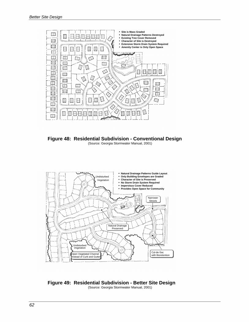
Better Site Design
62
Figure 48: Residential Subdivision - Conventional Design
(Source: Georgia Stormwater Manual, 2001) Figure 49: Residential Subdivision - Better Site Design
(Source: Georgia Stormwater Manual, 2001)
Site is Mass Graded Natural Drainage Patterns Destroyed Existing Tree Cover Removed Character of Site is Destroyed Extensive Storm Drain System Required Amenity Center is Only Open Space
Cul-de-Sac with Bioretention
UndisturbedVegetation
Open Vegetated Channel Instead of Curb and Gutter
Undisturbed Vegetation
Natural DrainagePreserved
Natural Drainage Patterns Guide Layout Only Building Envelopes are Graded Character of Site is Preserved No Storm Drain System Required Impervious Cover Reduced Provides Open Space for Community
NarrowerStreets
NarrowerStreets

Better Site Design
63
Figure 50: Commercial Development - Conventional Design
(Source: Georgia Stormwater Manual, 2001) Figure 51: Commercial Development - Better Site Design
(Source: Georgia Stormwater Manual, 2001)
ConcentratedParking AreaConcentrated Parking Area
Revegetated(Disturbed)Area
Revegetated(Disturbed)Area
WetExtendedDetentionPond
WetExtendedDetentionPond
Drugstore Shops Supermarket
Shops
Restaurant
Revegetated(Disturbed)
Area
Revegetated(Disturbed)
Area
ExtendedDetentionPond
DryExtendedDetentionPond
BioretentionAreaBioretentionArea
UndisturbedBufferUndisturbedBuffer
Undisturbed Buffer
UndisturbedBuffer
BioretentionIslandsBioretentionIslands
DispersedParking
DispersedParking
Drugstore Shops
SupermarketRestaurant
Shops
Shops

Better Site Design
64
4 REFERENCES Arendt, Randall. 1994. Rural by Design: Maintaining Small Town Character. Planners Press,
American Planning Association. Chicago, IL. Arendt, Randall. 1994. Designing Open Space Subdivisions: A Practical Step-by-Step Approach.
Natural Lands Trust, Inc. Media, PA. Arendt, Randall. 1996. Conservation Design for Subdivisions: A Practical Guide to Creating
Open Space Networks. American Planning Association. Chicago, IL. Atlanta Regional Commission. August 2001. Georgia Stormwater Management Manual.
Atlanta, GA. Berkshire Regional Planning Commission. 2003. The Massachusetts Buffer Manual: Using
Vegetated Buffers to Protect our Lakes and Rivers. Prepared for the Massachusetts Department of Environmental Protection. Boston, MA.
Blankinship, Donna Gordon. Jan/Feb 2005. Creeks are Coming Back into the Light. Article from
Stormwater Magazine Vol. 6, No. 1. Forester Communications. Caledonia, MI. Cappiella, K., T. Schueler, T. Wright. 2004. Urban Watershed Forestry Manual. Center for Watershed Protection. August 2003. New York State Stormwater Management Design
Manual. Prepared for New York State Department of Environmental Conservation, Albany, NY. http://www.dec.state.ny.us/website/dow/toolbox/swmanual/#Downloads
Center for Watershed Protection. 1998. Better Site Design: A Handbook for Changing
Development Rules in Your Community. Center for Watershed Protection, Ellicott City, MD. Center for Watershed Protection. July 1998. Nutrient Loading from Conventional and Innovative
Site Development. Prepared for: Chesapeake Research Consortium. Center for Watershed Protection, Ellicott City, MD.
Center for Watershed Protection. 1998. Better Site Design: An Assessment of the Better Site
Design Principles for Communities Implementing the Chesapeake Bay Preservation Act.. Center for Watershed Protection, Ellicott City, MD.
Center for Watershed Protection. 2000. Introduction to Better Site Design Slideshow. Available
from www.stormwatercenter.net Center for Watershed Protection. October 2001. Redevelopment Roundtable Consensus
Agreement: Smart Site Practices for Redevelopment and Infill Practices. Center for Watershed Protection, Ellicott City, MD.

Better Site Design
65
Center for Watershed Protection. 2005. Better Site Design and Changing the Development Rules Slideshow. Presented at New Windsor, New York, June 21-22, 2005.
DDNREC. 1997. Conservation Design for Stormwater Management. Delaware Department of
Natural Resources and Environmental Control and the Environmental Management Centre of the Bradywine Conservancy.
Green Roofs for Healthy Cities website: www.greenroofs.org Green Roofs.com website: www.greenroofs.com - The international greenroof industry’s
resource and online information portal. Hart, Leslie. 1994. Guiding Principles of Sustainable Design. Prepared for the U.S Department
of the Interior and the National Parks Service. Institute of Traffic Engineers (ITE). 2001. Residential Streets, Third Edition. Institute of Traffic
Engineers, Publication No. LP-630. Institute of Traffic Engineers (ITE). 1999. Traditional Neighborhood Development Street Design
Guidelines. Institute of Traffic Engineers, Publication No. RP-027A. Institute of Traffic Engineers (ITE). 1997. The Aesthetics of Parking. Institute of Traffic
Engineers, Publication No. LP-090A. Institute of Traffic Engineers (ITE). 1997. Designing Neighborhood Streets. Institute of Traffic
Engineers, Publication No. VHS-027. Institute of Traffic Engineers (ITE). 1994. Guidelines for Parking Facility Location and Design.
Institute of Traffic Engineers, Publication No. RP-022A. Litman, Todd Alexander. 2004. The Economic Value of Walkability. Victoria Transport Policy
Institute. Victoria, British Columbia. Low Impact Development (LID) Center website: http://www.lowimpactdevelopment.org/ Maine Department of Environmental Protection. 1998. The Buffer Handbook: A Guide to
Creating Vegetated Buffers for Lakefront Properties. Maine DEP. Augusta, ME. Massachusetts Executive Office of Environmental Affairs (EOEA). 2005. Smart Growth Toolkit.
Boston, MA. Metropolitan Area Planning Council (MAPC). 2005. Massachusetts Low Impact Development
Toolkit Fact Sheets. Metropolitan Area Planning Council. Boston, MA. MPCA. 1989. Best Management Practices for Minnesota. Minnesota Pollution Control Agency. Minneapolis, MN.
Better Site Design
66
Pinkham, Richard. Nov/Dec 2001. Daylighting: New Life for Buried Streams. Article from
Stormwater Magazine Vol. 2, No. 6. Forester Communications. Caledonia, MI. City of Portland, Oregon. September 2004. Stormwater Management Manual. Bureau of
Environmental Services, Portland, OR. Prince George’s County, MD. June 1999. Low-Impact Development Design Strategies: An
Integrated Design Approach. Prince George’s County, Maryland, Department of Environmental Resources, Largo, Maryland.
Rhode Island Department of Environmental Management. January 2005. The Urban
Environmental Design Manual. Rhode Island Department of Environmental Management, Providence, Rhode Island.
Schueler, T. 1995. Site Planning for Urban Stream Protection. Prepared for: Metropolitan
Washington Council of Governments. Washington, DC. Center for Watershed Protection, Ellicott City, MD.
Urban Land Institute (ULI). 1992. Density by Design. James W. Wetling and Lloyd W. Bookout,
editors. Urban Land Institute, Washington, DC. U.S. Environmental Protection Agency. 1999. Parking Alternatives: Making Way for Urban
Infill and Brownfields Redevelopment. U.S. EPA Urban and Economic Development Division. Washington, DC.


![[Pubcon 2008] eCommerce Site Optimization](https://static.documents.pub/doc/80x56/55a5d5371a28abd3148b4713/pubcon-2008-ecommerce-site-optimization.jpg)


