37
Biodiversity Action Plan City of Charles Sturt 2017-2030
Biodiversity Action Plan
City of Charles Sturt
2017-2030
ii
Biodiversity Action Plan City of Charles Sturt
2017-2030
Prepared by:
Seed Consulting Services
106 Gilles Street, Adelaide, South Australia 5000
P. +61 8 8232 4823
W. www.seedcs.com.au
Ref: 738 CCST_BAP-MASTER_FINAL_170817
Final: 17 August 2017
iii
Contents 1 Executive Summary ..................................................................................................... 1
2 Introduction .................................................................................................................. 3
3 Biodiversity Action Plan .............................................................................................. 5
3.1 How to use this plan .................................................................................................................... 5
3.2 Overarching goals ....................................................................................................................... 5
3.3 Biodiversity Action Areas ............................................................................................................ 5
3.3.1 BAA 1: Flora and fauna ......................................................................................................................... 5
3.3.2 BAA 2: Urban forests ............................................................................................................................. 6
3.3.3 BAA 3: Water quality and aquatic environments .................................................................................... 6
3.3.4 BAA 4: Education and citizen science ................................................................................................... 6
3.4 Action Table Framework ............................................................................................................. 6
3.4.1 Biodiversity Action Area 1 – Flora & Fauna ........................................................................................... 7
3.4.2 Biodiversity Action Area 2 – Urban Forests ........................................................................................... 8
3.4.3 Biodiversity Action Area 3 – Water and Aquatic Environments .............................................................. 9
3.4.4 Biodiversity Action Area 4 – Education and Citizen Science ............................................................... 10
3.4.5 Biodiversity Action Area 5 – Monitoring and Evaluation....................................................................... 11
3.5 Action prioritisation .................................................................................................................... 12
4 Monitoring and Evaluation Program ......................................................................... 15
4.1 MEP Considerations ................................................................................................................. 16
4.2 MEP framework ......................................................................................................................... 16
4.2.1 Key elements of an MEP framework.................................................................................................... 17
5 Abbreviations ............................................................................................................. 19
6 Glossary ..................................................................................................................... 20
7 Cover Photo Credits .................................................................................................. 22
8 References ................................................................................................................. 23
9 Attachments ............................................................................................................... 25
9.1 Attachment A. Process flowchart .............................................................................................. 26
9.2 Attachment B. Primary habitat associations ............................................................................. 27
9.3 Attachment C. Action prioritisation scoring details .................................................................... 30
iv
Figures Figure 1. Example of an adaptive management cycle (taken from (33)) ....................... 15
Figure 2. MEP template with a hypothetical example application. ................................ 18
Tables Table 1. Document and resources reviewed in developing this Biodiversity Action
Plan. ..................................................................................................................................... 4
Table 2. Action prioritisation matrix, showing all BAA actions scored (out of 18) for
relative priority .................................................................................................................. 13
1
1 Executive Summary Biodiversity is recognised by the City of Charles Sturt as being an important consideration in
the ongoing strategic development and management of a healthy functioning City. This
Biodiversity Action Plan 2017-2030 represents the first biodiversity-focussed plan for the City
of Charles Sturt. As such, a key priority is identifying the current status quo of biodiversity
within the Council area and generating more informed biodiversity goals, targets and actions.
This Plan is intended to have linkages with existing Council plans and strategies, including
the: Community Plan 2016-2027; Corporate Plan 2016-2020; Environmental Plan 2014-
2020; Open Space Strategy 2025; and the Development Plan 2016.
OUR BIODIVERSITY
Our Biodiversity is defined as: “…the variety of different types of plant and animal life in a
particular region” (1); this includes terrestrial, aquatic and marine plants and animals, as well
as micro-organisms, insects, species living below the ground, and their ecosystems. A high
level of biodiversity, particularly biodiversity native to the region, is considered desirable and
an important indicator of well-functioning ecosystems and environmental health.
Biodiversity is often compromised in heavily disturbed environments, such as urban areas
and so by understanding the biodiversity of our urban landscape we can inform urban
design, development and strategic actions to improve biodiversity and in turn improve
environmental health and well-being for the benefit of plants, animals, and our community.
OUR GOALS
Our Biodiversity Action Plan seeks to:
• Enhance biodiversity – through benchmarking, pest management, collaborative actions
on private and public land, and corridor linkage and enhancement;
• Create diverse and connected open space – create biodiverse and structurally diverse
open spaces with multiple-use outcomes for community and environmental well-being,
and which are connected across the landscape and with people;
• Promote Education – the development of collaborative projects between Council,
community, government, and organisations to provide educational/social connections
and create opportunities for community leadership and civic participation; and
• Implement strategic drivers – influence and actively develop strategies to address and
facilitate climate change adaptation and biodiversity conservation in built form
development.
2
Through the development of this Plan (Attachment A) six overarching goals for the Plan’s
lifetime were identified, specifically -
1. Biodiversity is enhanced and diversified across different habitat types;
2. Native plants and animals dominate the Council’s biodiversity;
3. Council and community understand and value biodiversity within the Council area;
4. Biodiversity areas support social and cultural connections;
5. Novel solutions support natural systems; and
6. Council has a clear direction and strategy for future-proofing biodiversity.
The development process also identified the following four key Biodiversity Action Areas
(BAAs). Specific and measurable actions have been developed accordingly, to develop and
enhance our biodiversity whilst both developing and working collaboratively with our
community.
• The identified Biodiversity Action Areas are;
• Flora and fauna;
• Urban forests;
• Water quality and aquatic environments; and
• Education and citizen science.
OUR FUTURE
This Plan is intended to guide biodiversity management, as well as resource allocation, over
the next 13 years to encompass timings of the City’s existing plans and strategies. An
integral, parallel to the Plan is a Monitoring and Evaluation Program (MEP) to assess the
relative success of actions and ensure the ongoing delivery of biodiversity actions across the
Council area. It is expected that the Plan will be evaluated against an MEP each year, with
a full revision and update undertaken in the year 2029 to ensure uninterrupted delivery of
biodiversity action post-2030.
3
2 Introduction The City of Charles Sturt is a progressive local government organisation committed to
protecting and enhancing biodiversity and ecological systems. We understand the role, value
and importance of biodiversity in the region, this is further highlighted through our leading
strategic document, our Community Plan, specifically:
• Our Community – A strong and connected community
Educate and regulate to enable a safe and healthy environment.
• Our Liveability - A liveable City of great places
Enhance the quality and diversity of open and public spaces.
• Our Environment - An environmentally responsible & sustainable City
Continue to implement climate change mitigation and adaptation solutions.
Enhance the state of the City’s environment and biodiversity.
Lead and educate to reduce the City’s impact on the environment and build
resilience.
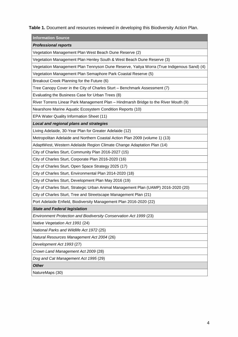
The development of this Biodiversity Action Plan will form an integral component of Council’s
strategic-decision making to 2030 and will contribute to creating a more liveable City for
people and biodiversity. In doing so, the BAP will have key linkages to the living Green
Environmental Plan and the Open Space Strategy (2025) as well as State and Federal
legislation and regional NRM objectives. To ensure these links, a range of key documents
and resources were reviewed (Table 1).
Council staff, neighbouring Councils, and community members have provided input in the
development of the BAP through a collaborative workshop process. This valuable process
has enabled the vision and expectations of Council and the community to merge into a
powerful biodiversity vision for the City.
The actions identified in this plan are a mix of investigations and data gathering at the high
level through to specific actions. Combined, this approach is designed to assist provision of
information to guide subsequent development of actions and data that can provide a
scientific basis for managing biodiversity in the long-term.
By its very nature, biodiversity is a complex web of life; an ever-changing interaction
between the natural and built environments and therefore it cannot be managed within rigid
sets of guidelines or actions and flexibility is required.
4
Table 1. Document and resources reviewed in developing this Biodiversity Action Plan.
Information Source
Professional reports
Vegetation Management Plan West Beach Dune Reserve (2)
Vegetation Management Plan Henley South & West Beach Dune Reserve (3)
Vegetation Management Plan Tennyson Dune Reserve, Yaitya Worra (True Indigenous Sand) (4)
Vegetation Management Plan Semaphore Park Coastal Reserve (5)
Breakout Creek Planning for the Future (6)
Tree Canopy Cover in the City of Charles Sturt – Benchmark Assessment (7)
Evaluating the Business Case for Urban Trees (8)
River Torrens Linear Park Management Plan – Hindmarsh Bridge to the River Mouth (9)
Nearshore Marine Aquatic Ecosystem Condition Reports (10)
EPA Water Quality Information Sheet (11)
Local and regional plans and strategies
Living Adelaide, 30-Year Plan for Greater Adelaide (12)
Metropolitan Adelaide and Northern Coastal Action Plan 2009 (volume 1) (13)
AdaptWest, Western Adelaide Region Climate Change Adaptation Plan (14)
City of Charles Sturt, Community Plan 2016-2027 (15)
City of Charles Sturt, Corporate Plan 2016-2020 (16)
City of Charles Sturt, Open Space Strategy 2025 (17)
City of Charles Sturt, Environmental Plan 2014-2020 (18)
City of Charles Sturt, Development Plan May 2016 (19)
City of Charles Sturt, Strategic Urban Animal Management Plan (UAMP) 2016-2020 (20)
City of Charles Sturt, Tree and Streetscape Management Plan (21)
Port Adelaide Enfield, Biodiversity Management Plan 2016-2020 (22)
State and Federal legislation
Environment Protection and Biodiversity Conservation Act 1999 (23)
Native Vegetation Act 1991 (24)
National Parks and Wildlife Act 1972 (25)
Natural Resources Management Act 2004 (26)
Development Act 1993 (27)
Crown Land Management Act 2009 (28)
Dog and Cat Management Act 1995 (29)
Other
NatureMaps (30)
5
3 Biodiversity Action Plan
3.1 How to use this plan
It is intended that this plan help the Council and community to positively manage biodiversity
from 2017 to 2030. A revision point in 2029 is proposed to enable the Plan and biodiversity
management strategy to seamlessly follow from 2030.
3.2 Overarching goals
The targets and actions contained herein (Section 3.4) have been developed to achieve the
following overarching goals of this Biodiversity Action Plan:
• Council and community understand and value biodiversity within the Council area;
• Biodiversity is enhanced and diversified across the BAAs;
• BAAs support social and cultural connections;
• Native plants and animals dominate the Council’s biodiversity;
• Novel solutions support natural systems; and
• Council has a clear direction and strategy for future-proofing biodiversity and BAAs.
These goals were set through discussion and collaboration of Council and community in the
workshops conducted during the information review and conceptual development of the
BAP.
3.3 Biodiversity Action Areas
Four key Biodiversity Action Areas (BAAs) have been developed to provide a framework for
the targets and actions outlined herein and to prevent repetition of actions which may need
to be applied across multiple habitat associations. The BAAs identify key biodiversity action
themes and allow for the provision of specific strategic alignment to other Council documents
such as, the Open Space Strategy, Adapt West, and the Living Green Strategy.
3.3.1 BAA 1: Flora and fauna
The protection and enhancement of flora and fauna habitats through ongoing management
of new and existing sites will improve urban biodiversity, minimise threats to biodiversity, and
provide opportunity for community education and interaction.
6
3.3.2 BAA 2: Urban forests
Enhancing and maintaining urban forests through urban forestry practices is a critical
element in improving the health and well-being of environments and people. Urban forestry
can be described as “…the art, science, and technology of managing trees and forest
resources in and around urban community ecosystems for the physiological, sociological,
economic, and aesthetic benefits trees provide society” (31).
3.3.3 BAA 3: Water quality and aquatic environments
These areas include all non-oceanic water bodies (i.e. rivers, lakes, ponds, and wetlands)
and associated aquatic and fringing vegetation. Improvements to the quality of water
throughout the City are integral to supporting biodiversity.
3.3.4 BAA 4: Education and citizen science
Our community are paramount to the successful implementation of this Action Plan.
Education through interaction and citizen science will underpin improvements and ongoing
commitment to biodiversity improvements.
For each BAA, an action table has been developed which outlines the: target, relevant
strategy/ies, practical actions, and indicators for measuring the success/completion of each
action. The targets, actions and indicators may be directly transferred in the development of
a Monitoring and Evaluation Plan (MEP) for the BAP (see Section 4).
3.4 Action Table Framework
The Plan is built around a framework of Strategies, Targets, Indicators and Actions, outlined
for each key Biodiversity Action Area, and defined (1) as:
• Strategy – direction developed to an overall goal; and
• Targets – a measurable to achieve the goals; and
• Indicators – a short term measurable contributing to the target; and
• Actions – a specific set of steps to achieve goals.
A S.M.A.R.T. approach has been applied to describing targets, meaning that targets are:
Specific, Measurable, Agreed upon, Realistic and Time-based. This is a well-used, trusted
and demonstrable process for action planning which facilitates the process of monitoring and
evaluation (Section 4)
7
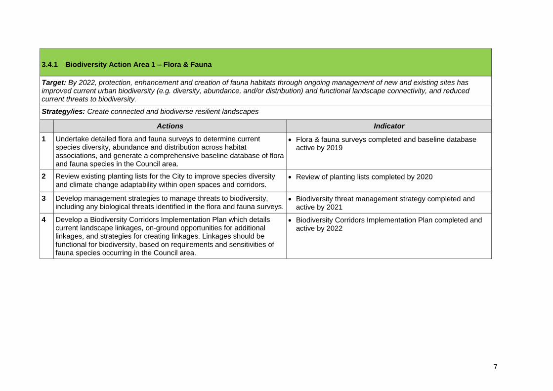
3.4.1 Biodiversity Action Area 1 – Flora & Fauna
Target: By 2022, protection, enhancement and creation of fauna habitats through ongoing management of new and existing sites has improved current urban biodiversity (e.g. diversity, abundance, and/or distribution) and functional landscape connectivity, and reduced current threats to biodiversity.
Strategy/ies: Create connected and biodiverse resilient landscapes
Actions Indicator
1 Undertake detailed flora and fauna surveys to determine current species diversity, abundance and distribution across habitat associations, and generate a comprehensive baseline database of flora and fauna species in the Council area.
• Flora & fauna surveys completed and baseline database active by 2019
2 Review existing planting lists for the City to improve species diversity and climate change adaptability within open spaces and corridors.
• Review of planting lists completed by 2020
3 Develop management strategies to manage threats to biodiversity, including any biological threats identified in the flora and fauna surveys.
• Biodiversity threat management strategy completed and active by 2021
4 Develop a Biodiversity Corridors Implementation Plan which details current landscape linkages, on-ground opportunities for additional linkages, and strategies for creating linkages. Linkages should be functional for biodiversity, based on requirements and sensitivities of fauna species occurring in the Council area.
• Biodiversity Corridors Implementation Plan completed and active by 2022
8
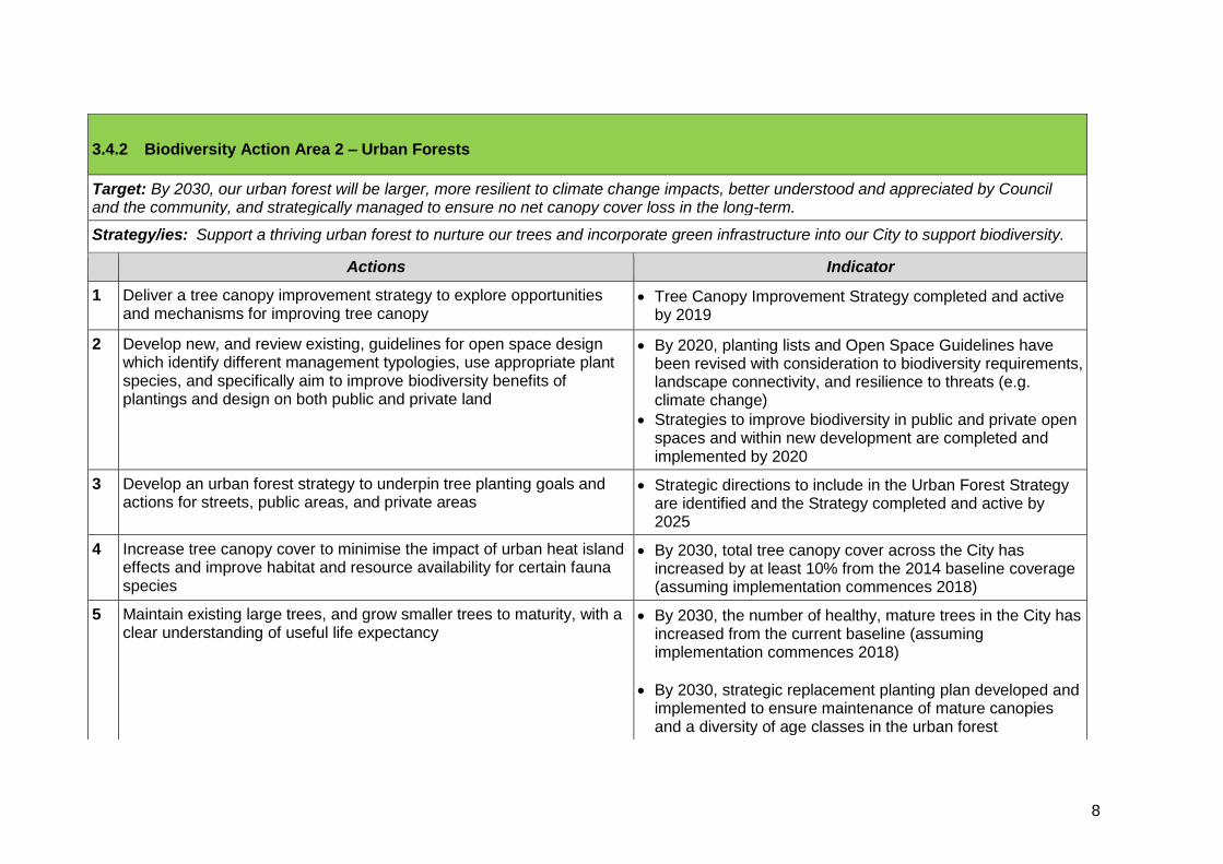
3.4.2 Biodiversity Action Area 2 – Urban Forests
Target: By 2030, our urban forest will be larger, more resilient to climate change impacts, better understood and appreciated by Council and the community, and strategically managed to ensure no net canopy cover loss in the long-term.
Strategy/ies: Support a thriving urban forest to nurture our trees and incorporate green infrastructure into our City to support biodiversity.
Actions Indicator
1 Deliver a tree canopy improvement strategy to explore opportunities and mechanisms for improving tree canopy
• Tree Canopy Improvement Strategy completed and active by 2019
2 Develop new, and review existing, guidelines for open space design which identify different management typologies, use appropriate plant species, and specifically aim to improve biodiversity benefits of plantings and design on both public and private land
• By 2020, planting lists and Open Space Guidelines have been revised with consideration to biodiversity requirements, landscape connectivity, and resilience to threats (e.g. climate change)
• Strategies to improve biodiversity in public and private open spaces and within new development are completed and implemented by 2020
3 Develop an urban forest strategy to underpin tree planting goals and actions for streets, public areas, and private areas
• Strategic directions to include in the Urban Forest Strategy are identified and the Strategy completed and active by 2025
4 Increase tree canopy cover to minimise the impact of urban heat island effects and improve habitat and resource availability for certain fauna species
• By 2030, total tree canopy cover across the City has increased by at least 10% from the 2014 baseline coverage (assuming implementation commences 2018)
5 Maintain existing large trees, and grow smaller trees to maturity, with a clear understanding of useful life expectancy
• By 2030, the number of healthy, mature trees in the City has increased from the current baseline (assuming implementation commences 2018)
• By 2030, strategic replacement planting plan developed and implemented to ensure maintenance of mature canopies and a diversity of age classes in the urban forest
9
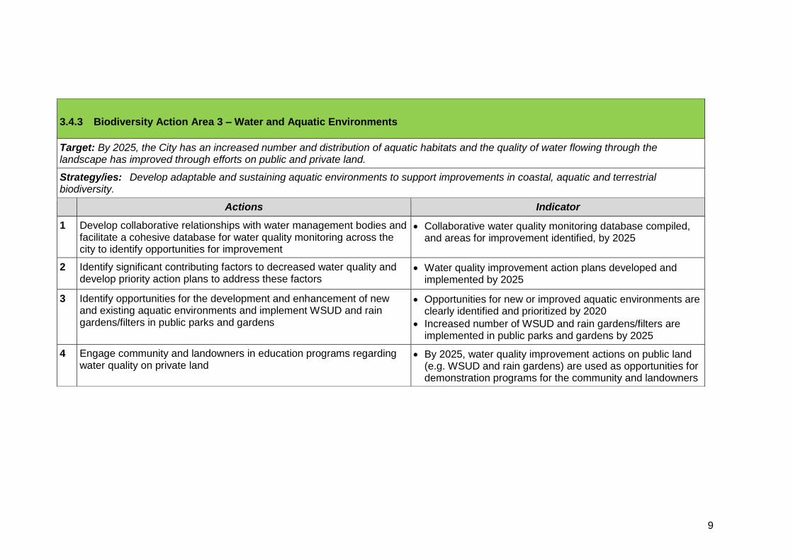
3.4.3 Biodiversity Action Area 3 – Water and Aquatic Environments
Target: By 2025, the City has an increased number and distribution of aquatic habitats and the quality of water flowing through the landscape has improved through efforts on public and private land.
Strategy/ies: Develop adaptable and sustaining aquatic environments to support improvements in coastal, aquatic and terrestrial biodiversity.
Actions Indicator
1 Develop collaborative relationships with water management bodies and facilitate a cohesive database for water quality monitoring across the city to identify opportunities for improvement
• Collaborative water quality monitoring database compiled, and areas for improvement identified, by 2025
2 Identify significant contributing factors to decreased water quality and develop priority action plans to address these factors
• Water quality improvement action plans developed and implemented by 2025
3 Identify opportunities for the development and enhancement of new and existing aquatic environments and implement WSUD and rain gardens/filters in public parks and gardens
• Opportunities for new or improved aquatic environments are clearly identified and prioritized by 2020
• Increased number of WSUD and rain gardens/filters are implemented in public parks and gardens by 2025
4 Engage community and landowners in education programs regarding water quality on private land
• By 2025, water quality improvement actions on public land (e.g. WSUD and rain gardens) are used as opportunities for demonstration programs for the community and landowners
10
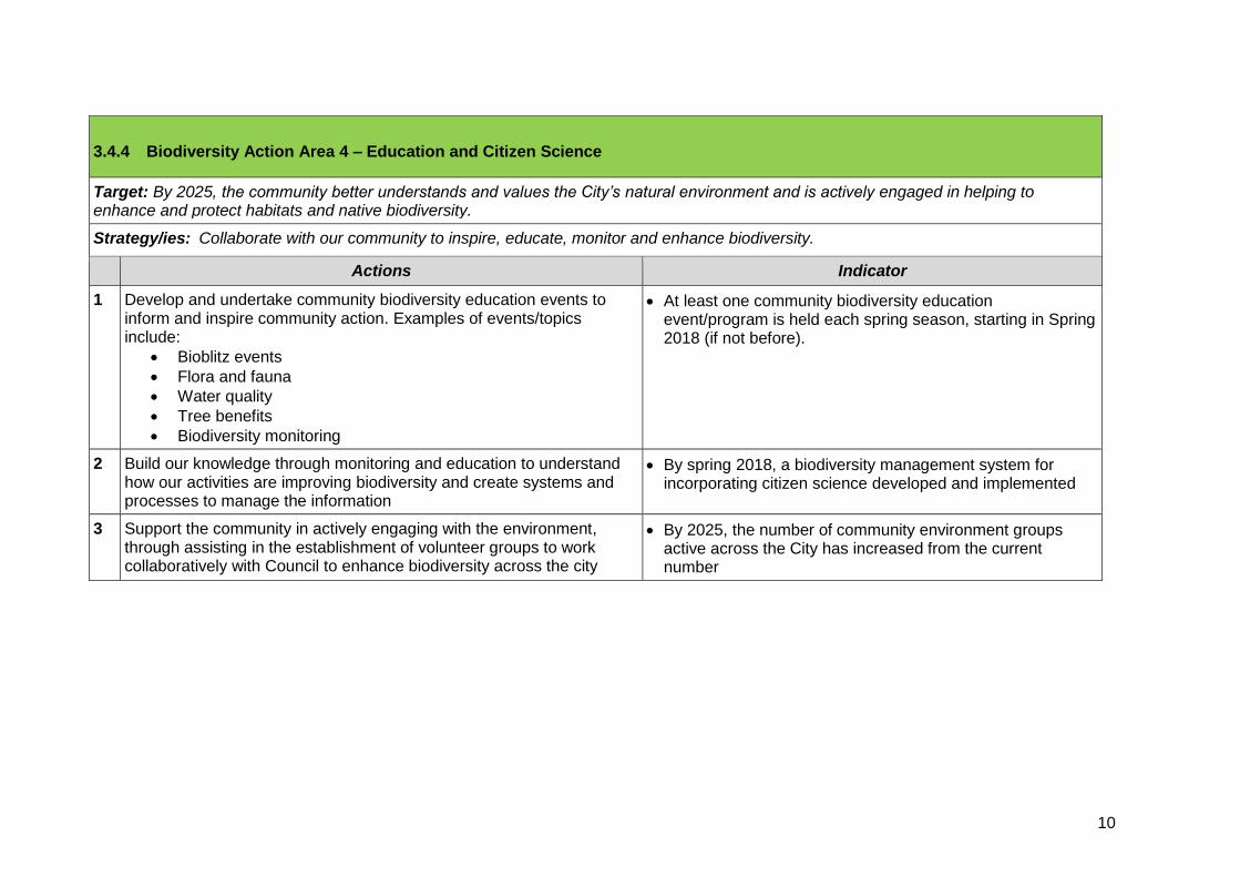
3.4.4 Biodiversity Action Area 4 – Education and Citizen Science
Target: By 2025, the community better understands and values the City’s natural environment and is actively engaged in helping to enhance and protect habitats and native biodiversity.
Strategy/ies: Collaborate with our community to inspire, educate, monitor and enhance biodiversity.
Actions Indicator
1 Develop and undertake community biodiversity education events to inform and inspire community action. Examples of events/topics include:
• Bioblitz events
• Flora and fauna
• Water quality
• Tree benefits
• Biodiversity monitoring
• At least one community biodiversity education event/program is held each spring season, starting in Spring 2018 (if not before).
2 Build our knowledge through monitoring and education to understand how our activities are improving biodiversity and create systems and processes to manage the information
• By spring 2018, a biodiversity management system for incorporating citizen science developed and implemented
3 Support the community in actively engaging with the environment, through assisting in the establishment of volunteer groups to work collaboratively with Council to enhance biodiversity across the city
• By 2025, the number of community environment groups active across the City has increased from the current number
11
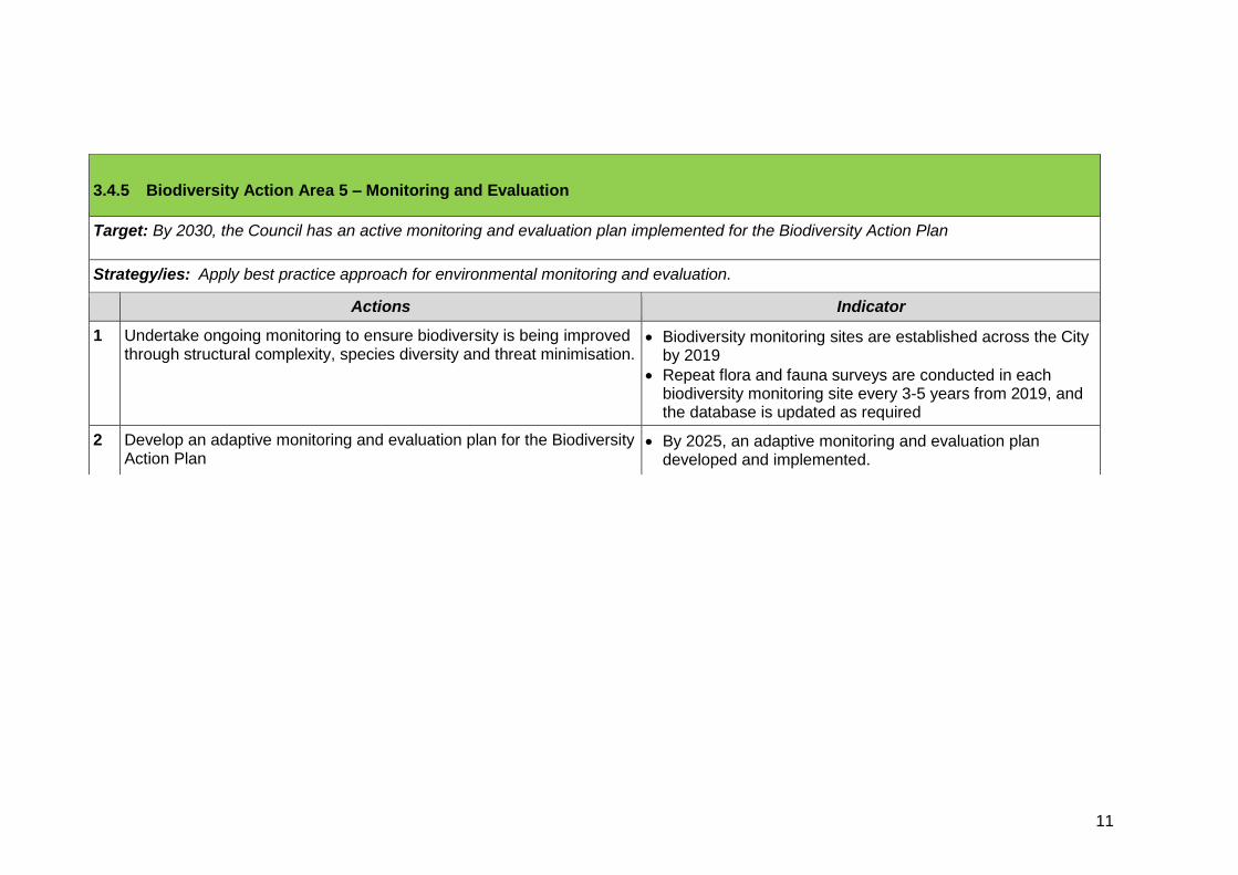
3.4.5 Biodiversity Action Area 5 – Monitoring and Evaluation
Target: By 2030, the Council has an active monitoring and evaluation plan implemented for the Biodiversity Action Plan
Strategy/ies: Apply best practice approach for environmental monitoring and evaluation.
Actions Indicator
1 Undertake ongoing monitoring to ensure biodiversity is being improved through structural complexity, species diversity and threat minimisation.
• Biodiversity monitoring sites are established across the City by 2019
• Repeat flora and fauna surveys are conducted in each biodiversity monitoring site every 3-5 years from 2019, and the database is updated as required
2 Develop an adaptive monitoring and evaluation plan for the Biodiversity Action Plan
• By 2025, an adaptive monitoring and evaluation plan developed and implemented.
12
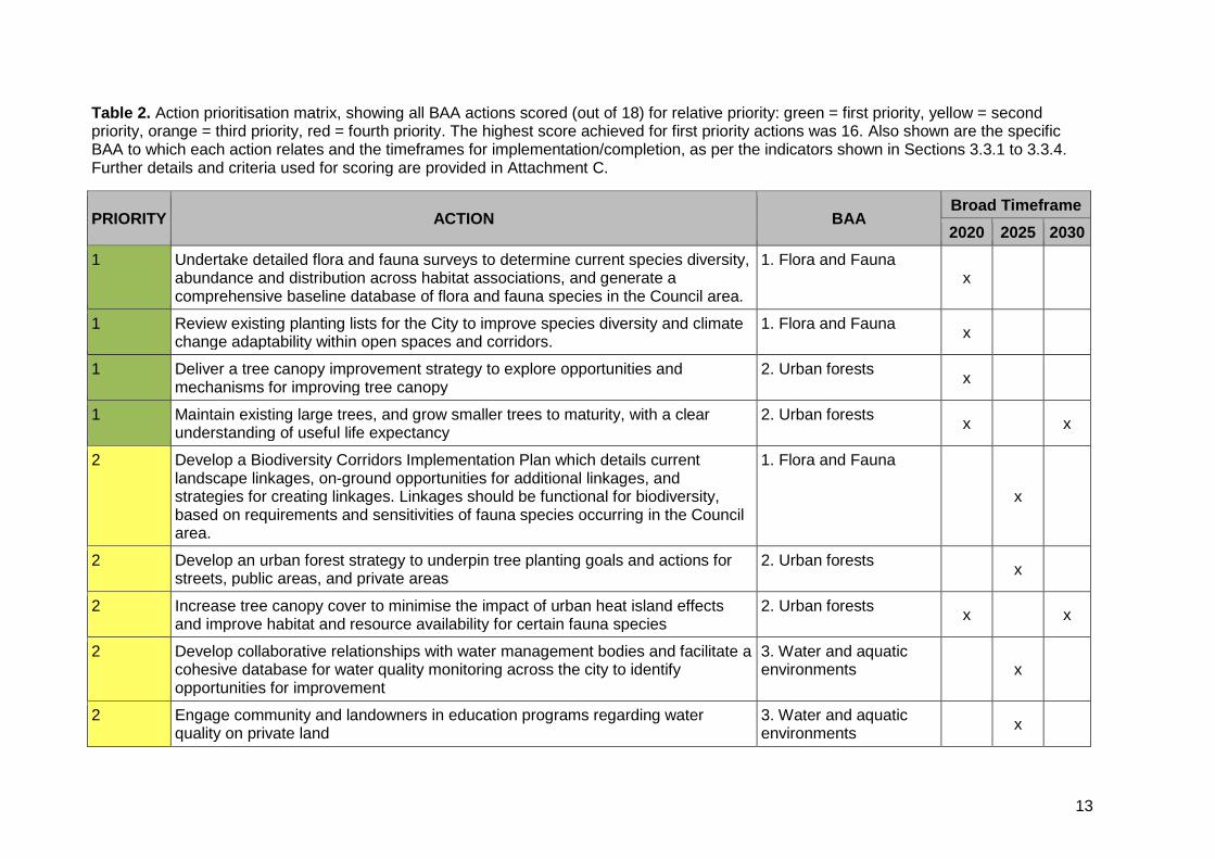
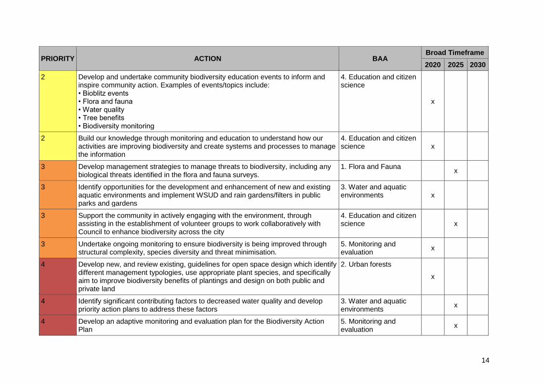
3.5 Action prioritisation
Table 2 has been developed to assist Council in implementing the BAP and has prioritised
the actions according to a range of criteria that influence successful uptake of projects.
The criteria used to assist setting priorities include:
• Technically possible;
• Cost;
• Work flow impact (internal);
• Motivation of staff;
• Public engagement; and
• Timeframe for implementation/completion.
Actions were scored 1 to 3 based on the perceived success, difficulty or potential problems
of the action, with a score of 3 being the best. A broad costing for actions was also included
in the scoring, though it is recognised that the prioritisation of individual projects to address
each Action, and the progressions of the Action Plan, will depend on the availability of future
funding. The highest aggregate scores were considered to be actions of the highest priority.
Further details regarding scoring of actions and broad costings is provided in Attachment C.
13
Table 2. Action prioritisation matrix, showing all BAA actions scored (out of 18) for relative priority: green = first priority, yellow = second priority, orange = third priority, red = fourth priority. The highest score achieved for first priority actions was 16. Also shown are the specific BAA to which each action relates and the timeframes for implementation/completion, as per the indicators shown in Sections 3.3.1 to 3.3.4. Further details and criteria used for scoring are provided in Attachment C.
PRIORITY ACTION BAA Broad Timeframe
2020 2025 2030
1 Undertake detailed flora and fauna surveys to determine current species diversity, abundance and distribution across habitat associations, and generate a comprehensive baseline database of flora and fauna species in the Council area.
1. Flora and Fauna x
1 Review existing planting lists for the City to improve species diversity and climate change adaptability within open spaces and corridors.
1. Flora and Fauna x
1 Deliver a tree canopy improvement strategy to explore opportunities and mechanisms for improving tree canopy
2. Urban forests x
1 Maintain existing large trees, and grow smaller trees to maturity, with a clear understanding of useful life expectancy
2. Urban forests x x
2 Develop a Biodiversity Corridors Implementation Plan which details current landscape linkages, on-ground opportunities for additional linkages, and strategies for creating linkages. Linkages should be functional for biodiversity, based on requirements and sensitivities of fauna species occurring in the Council area.
1. Flora and Fauna
x
2 Develop an urban forest strategy to underpin tree planting goals and actions for streets, public areas, and private areas
2. Urban forests x
2 Increase tree canopy cover to minimise the impact of urban heat island effects and improve habitat and resource availability for certain fauna species
2. Urban forests x x
2 Develop collaborative relationships with water management bodies and facilitate a cohesive database for water quality monitoring across the city to identify opportunities for improvement
3. Water and aquatic environments x
2 Engage community and landowners in education programs regarding water quality on private land
3. Water and aquatic environments
x
14
PRIORITY ACTION BAA Broad Timeframe
2020 2025 2030
2 Develop and undertake community biodiversity education events to inform and inspire community action. Examples of events/topics include: • Bioblitz events • Flora and fauna • Water quality • Tree benefits • Biodiversity monitoring
4. Education and citizen science
x
2 Build our knowledge through monitoring and education to understand how our activities are improving biodiversity and create systems and processes to manage the information
4. Education and citizen science x
3 Develop management strategies to manage threats to biodiversity, including any biological threats identified in the flora and fauna surveys.
1. Flora and Fauna x
3 Identify opportunities for the development and enhancement of new and existing aquatic environments and implement WSUD and rain gardens/filters in public parks and gardens
3. Water and aquatic environments x
3 Support the community in actively engaging with the environment, through assisting in the establishment of volunteer groups to work collaboratively with Council to enhance biodiversity across the city
4. Education and citizen science x
3 Undertake ongoing monitoring to ensure biodiversity is being improved through structural complexity, species diversity and threat minimisation.
5. Monitoring and evaluation
x
4 Develop new, and review existing, guidelines for open space design which identify different management typologies, use appropriate plant species, and specifically aim to improve biodiversity benefits of plantings and design on both public and private land
2. Urban forests
x
4 Identify significant contributing factors to decreased water quality and develop priority action plans to address these factors
3. Water and aquatic environments
x
4 Develop an adaptive monitoring and evaluation plan for the Biodiversity Action Plan
5. Monitoring and evaluation
x
15
4 Monitoring and Evaluation
Program Monitoring of biodiversity is not that same as measuring biodiversity. Measuring biodiversity
provides a snapshot in time, whereas, monitoring is a long-term, on-going process which
identifies temporal trends and allows decisions to be made regarding whether actions are
achieving desired biodiversity targets. Accordingly, biodiversity measurements taken over
time contribute to biodiversity monitoring.
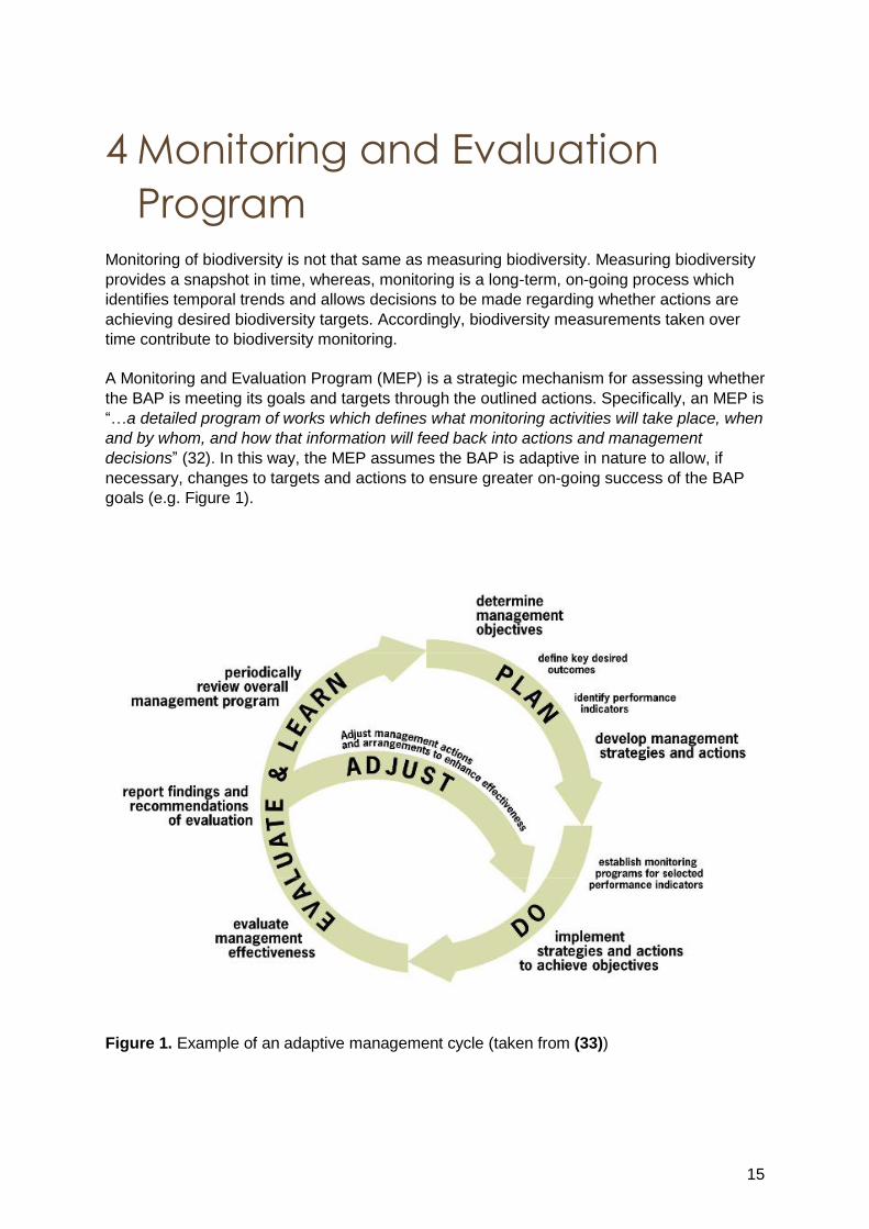
A Monitoring and Evaluation Program (MEP) is a strategic mechanism for assessing whether
the BAP is meeting its goals and targets through the outlined actions. Specifically, an MEP is
“…a detailed program of works which defines what monitoring activities will take place, when
and by whom, and how that information will feed back into actions and management
decisions” (32). In this way, the MEP assumes the BAP is adaptive in nature to allow, if
necessary, changes to targets and actions to ensure greater on-going success of the BAP
goals (e.g. Figure 1).
Figure 1. Example of an adaptive management cycle (taken from (33))
16
4.1 MEP Considerations
The MEP framework presented here has considered State, National and international best
practice for developing environmental guidelines and monitoring and evaluation frameworks.
Principally the MEP should be developed to be:
• Fit-for-purpose: tailored to the design, purpose and objectives of the projects and
programs;
• Credible: based on scientifically and administratively defensible methods and
approaches;
• Transparent: clearly demonstrates how public money has been spent, the resulting
outputs, and where possible, outcomes; and
• Cost effective: costs within allowable limits, and where possible draw on and link with
existing processes and information.
Further, in developing the MEP, the following should also be considered:
• Temporal scale: the monitoring framework should be established to exceed the lifetime
of the BAP, given that biodiversity concerns ecological processes and species
populations which tend to respond over long periods, rather than instantaneously after
implementation of an action.
For example, monitoring the impacts of fox control on native fauna populations may
require monitoring time-frames equivalent to multiple generations of native fauna to
identify the response of populations to the fox control action.
• Spatial scale: the appropriate scale for monitoring will vary depending on the action/s
and target/s being monitored.
For example, monitoring the effectiveness of landscape connectivity actions will
require focus at a broader, landscape-scale, whereas monitoring structural
vegetation complexity along the River Torrens will occur at a more localised scale.
• Socio-economics and stakeholder participation: particularly in urban areas, the
success or failure of many biodiversity management actions will be influenced by social
and economic factors. Where possible, communities and stakeholders likely to affected
by BAP actions, either positively or negatively, should be considered and monitored.
4.2 MEP framework
This Section provides the framework for developing an MEP for the BAP. Whilst this
framework should be considered in the initial implementation stages of the BAP, there is not
yet sufficient data available to prepare a detailed MEP, as is often the case at the
commencement of biodiversity projects (32). It is nonetheless important that the MEP outline
is developed in the initial BAP implementation stages, with further development and
17
refinement undertaken during implementation of the BAP, by drawing on a combination of
the data, observations and learnings of the actions (32). In many cases actions will set a
benchmark on which success (achievement of plan targets) and re-evaluation of the
direction of the BAP in 2029 will be made.
4.2.1 Key elements of an MEP framework
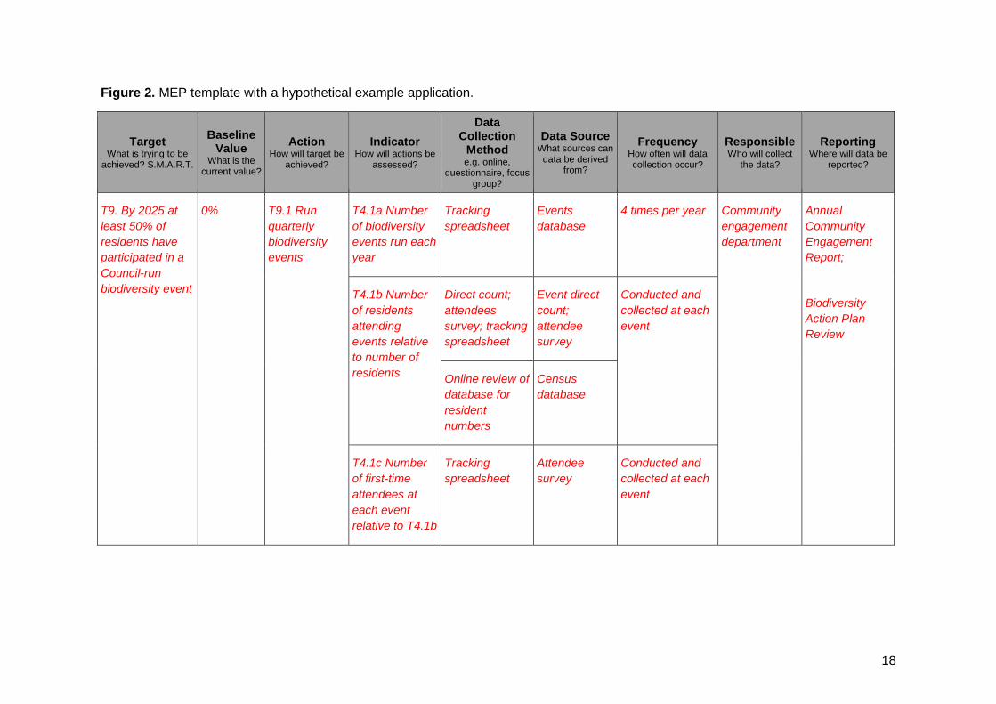
The MEP framework (Figure 2) contains the following nine elements:
1. Target: the desired outcome for a biodiversity element. Targets have been
developed to be SMART (Specific, Measurable, Agreed-upon, Realistic, Time-
based). Targets for each BAA of the BAP are shown in Section 3.4.
2. Baseline: the “current” condition for a Target, that is, it’s condition prior to or in the
early stages of implementation of actions. The baseline measurement provides a
benchmark for assessing progress towards achieving the Target.
3. Action: activities proposed to achieve the desired Target. Some actions in this BAP
apply to multiple Targets and/or multiple BAAs. Actions have been prioritised in
Section 3.5.
4. Indicator: what needs to be measured to assess whether an action is achieving the
desired Target. Indicators may be qualitative or quantitative variables but must be
able to be measured or described and when observed periodically, must be able to
demonstrate trends in biodiversity characteristics over time.
5. Data collection method: specific detail about how data will be collected for each
indicator.
6. Data source: identifies where data will be measured (i.e. data collected).
7. Frequency: how often indicators will be measured.
8. Responsible: who will be responsible for measuring indicators and collating data.
9. Reporting: identifies where records of indicators measurements will be reported.
18
Figure 2. MEP template with a hypothetical example application.
Target What is trying to be
achieved? S.M.A.R.T.
Baseline Value
What is the current value?
Action How will target be
achieved?
Indicator How will actions be
assessed?
Data Collection
Method e.g. online,
questionnaire, focus group?
Data Source What sources can data be derived
from?
Frequency How often will data collection occur?
Responsible Who will collect
the data?
Reporting Where will data be
reported?
T9. By 2025 at
least 50% of
residents have
participated in a
Council-run
biodiversity event
0% T9.1 Run
quarterly
biodiversity
events
T4.1a Number
of biodiversity
events run each
year
Tracking
spreadsheet
Events
database
4 times per year Community
engagement
department
Annual
Community
Engagement
Report;
Biodiversity
Action Plan
Review
T4.1b Number
of residents
attending
events relative
to number of
residents
Direct count;
attendees
survey; tracking
spreadsheet
Event direct
count;
attendee
survey
Conducted and
collected at each
event
Online review of
database for
resident
numbers
Census
database
T4.1c Number
of first-time
attendees at
each event
relative to T4.1b
Tracking
spreadsheet
Attendee
survey
Conducted and
collected at each
event
19
5 Abbreviations BAA Biodiversity Action Area
BAP Biodiversity Action Plan
CBSM Community Based Social Marketing
MEP Monitoring and Evaluation Program
WSUD Water sensitive urban design
20
6 Glossary
Abundance – the quantity or amount of something. When used in relation to species (i.e.
species abundance), it refers to the number of individuals of a particular species.
Action – used here to describe a specific set of steps to achieve goals.
Adapt – a term used to describe animals, plants, or habitats/ecosystems that are able to
change or adjust to suit new/altered conditions.
Baseline – describes the condition of target biodiversity prior to, or in the early stages of,
project implementation. It is a benchmark against which management-induced changes can
be identified and measured (32).
Bioblitz – an intense period of biological surveying (e.g. 24-36 hours) undertaken in an
attempt to record all living species within a designated area. Commonly conducted as a
collaborative activity between scientists, naturalists, organisations and community
volunteers.
Biodiverse – used in relation to a habitat or region having a high level of biodiversity.
Biodiversity – an umbrella term encompassing all species of plants, animals, and micro-
organisms, and the variation in ecosystems and ecological processes of which they are part.
It is a multi-dimensional concept, difficult to define in an operational sense and difficult to
measure (32).
Citizen science – scientific research conducted in whole or in part by amateur (i.e. non-
professional) scientists and/or community volunteers. Typically conducted in collaboration
with professional scientists. A bioblitz event is an example of citizen science.
Distribution – the spread of something over an area. When used in relation to species (i.e.
species distribution) it tends to indicate where areas of suitable environmental and habitat
conditions occur for a species. For this BAP, it may be used to indicate if a species is found
across the whole Council area, or restricted to certain localities or habitat types/associations.
Diversity – the amount of variation in something. When used in relation to species (i.e.
species diversity) it relates to the number of different species (e.g. to measure species
diversity is to quantify the number of different species; to increase species diversity is to
increase the number of different species).
Ecosystem – refers to the complex network of living organisms and their interactions with
each other and their environment.
Environment – the natural surroundings or conditions in which an animal or plant lives or
operates. Can be used to describe the whole of the natural world, or a particular area.
Functional landscape connectivity – the degree to which the landscape facilitates or
impedes movements of animals/plants between suitable habitat areas. Generally used for
21
species that are either unable or unwilling to move within habitats different to its own (e.g. a
frog may be unable or unwilling to move between water bodies without a suitable aquatic link
providing a functional connection).
Habitat – the type of place (i.e. environment) that a particular animal or plant usually lives.
Noting that animals may utilise different habitats for different purposes (e.g. foraging,
breeding, dispersal). Multiple habitats for different species may be found within broad habitat
associations.
Habitat association – a broad description of similar habitat types based on broad
environmental conditions, for example: coastal, aquatic, terrestrial. Different animals and
plants may utilise various habitats within one or more habitat associations.
Fauna – includes all vertebrate and invertebrate species occurring in terrestrial, marine and
aquatic environments.
Flora – includes all vegetation species occurring in terrestrial, marine and aquatic
environments.
Measuring [biodiversity] – data collected about a snap-shot in time of a specific biodiversity
value (e.g. number of species). Measurements are useful for comparing relative biodiversity
values (e.g. whether one area is more species-rich than another area) (32)
Monitoring [biodiversity] – comparing multiple measurements taken over time of the same
biodiversity value so as trends in changes can be identified and decisions made regarding
whether a management action is having the desired result or whether the action needs to be
changed.
Resilient – relates here to animal and plant species and/or habitats, environments or
ecosystems being able to withstand, recover quickly from, or adapt to threats and difficult
conditions.
Strategy – used here to refer to the direction developed to an overall goal.
Structural complexity – used here in relation to vegetation and habitats to describe the
amount of variation in vegetation cover layers (i.e. ground cover, shrub/understorey layer,
mid-storey, and canopy/over-storey layers). May also encapsulate elements such as fallen
logs. Generally, areas that are more structurally complex tend to provide habitat and
resources for more species.
Target – used here to describe a quantifiable element that may be measured to gauge
progress towards achieving goals.
Threat – anything that has a negative impact on animals, plants, habitats, environments and
ecosystems. For example, cats and dogs chasing/predating native animals, vegetation
clearing/land use change, climate change.
Indicator – a short-term measurable aspect contributing to the target.
Goal – what is trying to be broadly achieved through implementation of the targets and
actions.
22
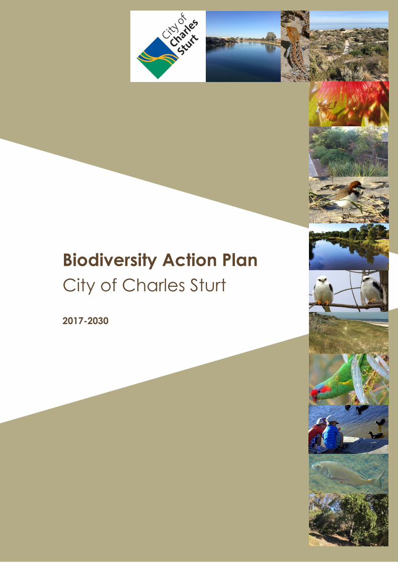
7 Cover Photo Credits
1. http://www.charlessturt.sa.gov.au/page.aspx?u=178 2017 2. West Lakes, 2017, Photo by J. Garden 3. Painted dragon (Ctenophorous pictus), Tennyson Dunes, Source: http://www.tennyson.org.au/assets/wildlife.html 4. Tennyson dunes, 2017, Source: Seed Consulting Services 5. Bee on eucalypt bloom, Semaphore Park, Source: Seed Consulting Services 6. Roadside plantings, 2017, West Lakes Shore, Source: Seed Consulting Services 7. Red-capped Plover (Charadrius ruficapillus), Semaphore beach, Source: Seed Consulting Services 8. River Torrens, 2017, Source: Seed Consulting Services 9. Black-shouldered kites, 2016, Source: Seed Consulting Services 10. Semaphore Beach dunes, 2017, Source: Seed Consulting Services 11. Musk lorikeet (Glossopsitta concinna), 2016, Semaphore Park, Source: Seed Consulting Services 12. Children with waterbirds, Delfin Island Duck Pond, 2016, Source: Seed Consulting Services 13. Bream species, West Lakes, Source: https://naturallysouthaustralia.com/2015/03/14/a-walk-around-west-lakes/ 14. Tennyson dunes, black-shouldered kite (Elanus axillaris). Source: http://www.tennyson.org.au/assets/wildlife.html
23
8 References 1. MacMillan Publishers Limited. MacMillan Dictionary. MacMillan Dictionary. [Online]
MacMillan Publishers Limited, 2009-2017. http://www.macmillandictionary.com/.
2. Lock CE, Cordingley SP. Vegetation Management Plan West Beach Dune Reserve,
West Beach. South Australia : SA Urban Forest Biodiversity Program, 2008.
3. Cordingley SP, Petherick CE. Vegetation Management Plan for the Henley South and
West Beach Dune Reserve. South Australia : City of Charles Sturt, 2005.
4. —. Vegetation Management Plan Tennyson Dune Reserve, Yaitya Worra (True
Indigenous Sand). Adelaide : SA Urban Forest Biodiversity Program, 2006.
5. —. Vegetation Management Plan Semaphore Park Coastal Reserve. Adelaide : SA Urban
Forest Biodiversity Program, 2006.
6. NR AMLR. Breakout Creek Planning for the Future. South Australia : Prepared for
Adelaide and Mount Lofty Ranges Natural Resources Management Board, 2015.
7. Seed Consulting Services. Tree Canopy Cover in the City of Charles Sturt - Benchmark
Assessment. South Australia : A report prepared for the City of Charles Sturt, 2016.
8. ENPSEC. Evaluating the Business Case for Urban Trees - DRAFT REPORT. South
Australia : Prepared for the Local Government Association SA, 2017.
9. Environmental and Biodiversity Services. River Torrens Linear Park Management Plan
- Hindmarsh Bridge to the River Mouth. South Australia : Report prepared for the City of
West Torrens and City of Charles Sturt, 2007.
10. Nelson, Matt, Gaylard, Sam and Noble, Warwick. Nearshore Marine Aquatic
Ecosystem Condition Reports - Gulf St Vincent Bioregional Assessment Report 2010-2011.
South Australia : Environment Protection Agency, 2013.
11. Environment Protection Agency. Water Quality Information Sheet: Defining Reference
Condition for South Australian Streams - Fleurieu Peninsula and Mount Lofty Ranges. South
Australia : Environment Protection Agency, 2016. EPA 1092/16.
12. Government of South Australia. Living Adelaide. Department of Planning, Transport
and Infrastructure. South Australia : Government of South Australia, 2016.
13. Caton B, Fotheringham D, Krahnert E, Pearson J, Royal M, Sandercock R.
Metropolitan Adelaide and Northern Coastal Action Plan (volume 1). South Australia :
Prepared for the Adelaide and Mount Lofty Ranges NRM Board and Department for
Environment and Heritage, 2009.
14. URPS, Seed Consulting Services, AECOM. AdaptWest Western Adelaide Region
Climate Change Adaptation Plan. South Australia : AdaptWest, 2016.
15. City of Charles Sturt. Community Plan 2016-2027. South Australia : City of Charles
Sturt, 2016.
16. —. Corporate Plan 2016-2027 . South Australia : City of Charles Sturt, 2016.
17. —. City of Charles Sturt Open Space Strategy 2025. South Australia : City of Charles
Sturt, 2015.
24
18. —. Living Green to 2020. South Australia : City of Charles Sturt, 2014.
19. —. Development Plan . South Australia : Charles Sturt Council, 2016.
20. —. Strategic Urban Animal Management Plan (UAMP) 2016-2020. South Australia : City
of Charles Sturt, 2016.
21. —. Tree and Streetscape Management Plan (Streets, Reserves and Streetscapes).
South Australia : City of Charles Sturt, 2016.
22. Port Adelaide Enfield. Biodiveristy Management Plan 2016-2020. South Australia : Port
Adelaide Enfield, 2016.
23. Department of the Environment and Energy. Environment Protection and Biodiversity
Conservation Act 1999. Canberra : Australian Government, 1999.
24. Government of South Australia. Native Vegetation Act 1991. South Australia :
Government of South Australia, 1991.
25. —. National Parks and Wildlife Act 1972. South Australia : Government of South
Australia, 1972.
26. —. Natural Resources Management Act 2004. South Australia : Government of South
Australia, 2004.
27. —. Development Act 1993. South Australia : Government of South Australia, 1993.
28. —. Crown Land Managment Act 2009. South Australia : Government of South Australia,
2009.
29. —. Dog and Cat Management Act 1995. South Australia : Government of South
Australia, 2017. Verson 19.4.2017.
30. —. NatureMaps. Enviro Data SA. [Online] 2017.
https://data.environment.sa.gov.au/NatureMaps/Pages/default.aspx .
31. Helms, J A (Ed.). The Dictionary of Forestry. Bethesda : Society of American Foresters,
1998; In: Schwab, J C (Ed.) Planning the Urban Forest: Ecology, Economy, and Community
Development. Report Number 555. American Planning Association, 2009.
32. Global Environment Division. Guidelines for Monitoring and Evaluation for Biodiversity
Projects. s.l. : Environment Department, World Bank, 1998. 27031.
33. Jones, G. Is the management plan achieving its objectives? [book auth.] G Worboys, M
Lockwood and T De lacy. Protected Area Management. Principles and Practice. Oxford :
Oxford University Press, 2005.
25
9 Attachments
Attachment A. Process flowchart
Attachment B. Primary habitat associations
Attachment C. Action prioritisation scoring details
26
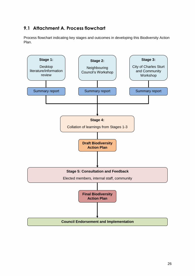
9.1 Attachment A. Process flowchart
Process flowchart indicating key stages and outcomes in developing this Biodiversity Action
Plan.
Stage 1:
Desktop literature/information
review
Stage 2:
Neighbouring
Council’s Workshop
Stage 3:
City of Charles Sturt
and Community
Workshop
Stage 4:
Collation of learnings from Stages 1-3
Draft Biodiversity
Action Plan
Stage 5: Consultation and Feedback
Elected members, internal staff, community
Council Endorsement and Implementation
Summary report Summary report Summary report
Final Biodiversity
Action Plan
27
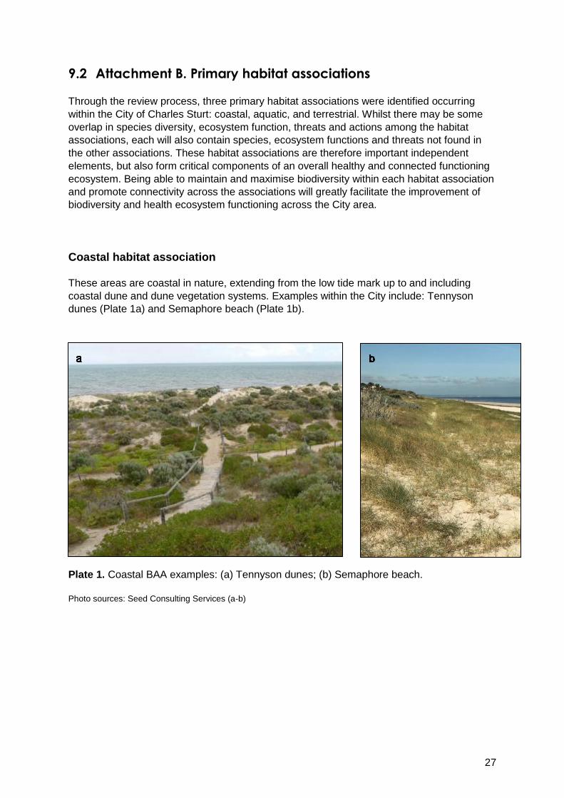
9.2 Attachment B. Primary habitat associations
Through the review process, three primary habitat associations were identified occurring
within the City of Charles Sturt: coastal, aquatic, and terrestrial. Whilst there may be some
overlap in species diversity, ecosystem function, threats and actions among the habitat
associations, each will also contain species, ecosystem functions and threats not found in
the other associations. These habitat associations are therefore important independent
elements, but also form critical components of an overall healthy and connected functioning
ecosystem. Being able to maintain and maximise biodiversity within each habitat association
and promote connectivity across the associations will greatly facilitate the improvement of
biodiversity and health ecosystem functioning across the City area.
Coastal habitat association
These areas are coastal in nature, extending from the low tide mark up to and including
coastal dune and dune vegetation systems. Examples within the City include: Tennyson
dunes (Plate 1a) and Semaphore beach (Plate 1b).
Plate 1. Coastal BAA examples: (a) Tennyson dunes; (b) Semaphore beach.
Photo sources: Seed Consulting Services (a-b)
28
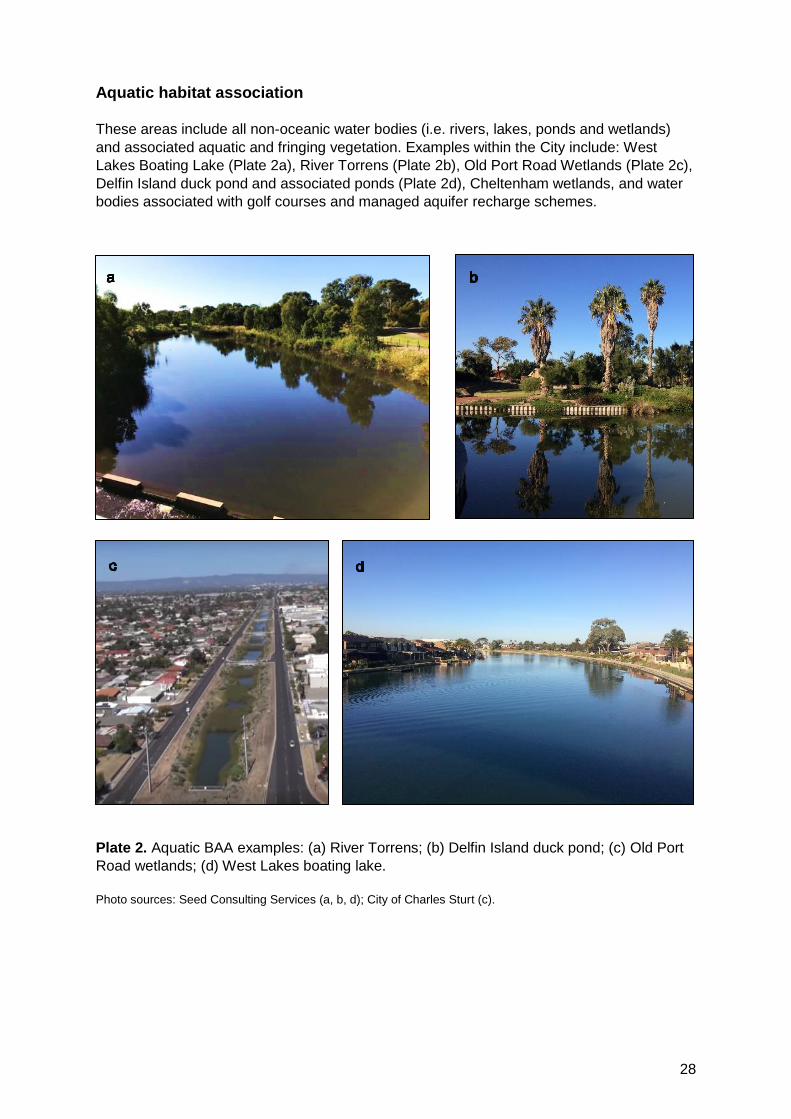
Aquatic habitat association
These areas include all non-oceanic water bodies (i.e. rivers, lakes, ponds and wetlands)
and associated aquatic and fringing vegetation. Examples within the City include: West
Lakes Boating Lake (Plate 2a), River Torrens (Plate 2b), Old Port Road Wetlands (Plate 2c),
Delfin Island duck pond and associated ponds (Plate 2d), Cheltenham wetlands, and water
bodies associated with golf courses and managed aquifer recharge schemes.
Plate 2. Aquatic BAA examples: (a) River Torrens; (b) Delfin Island duck pond; (c) Old Port
Road wetlands; (d) West Lakes boating lake.
Photo sources: Seed Consulting Services (a, b, d); City of Charles Sturt (c).
29
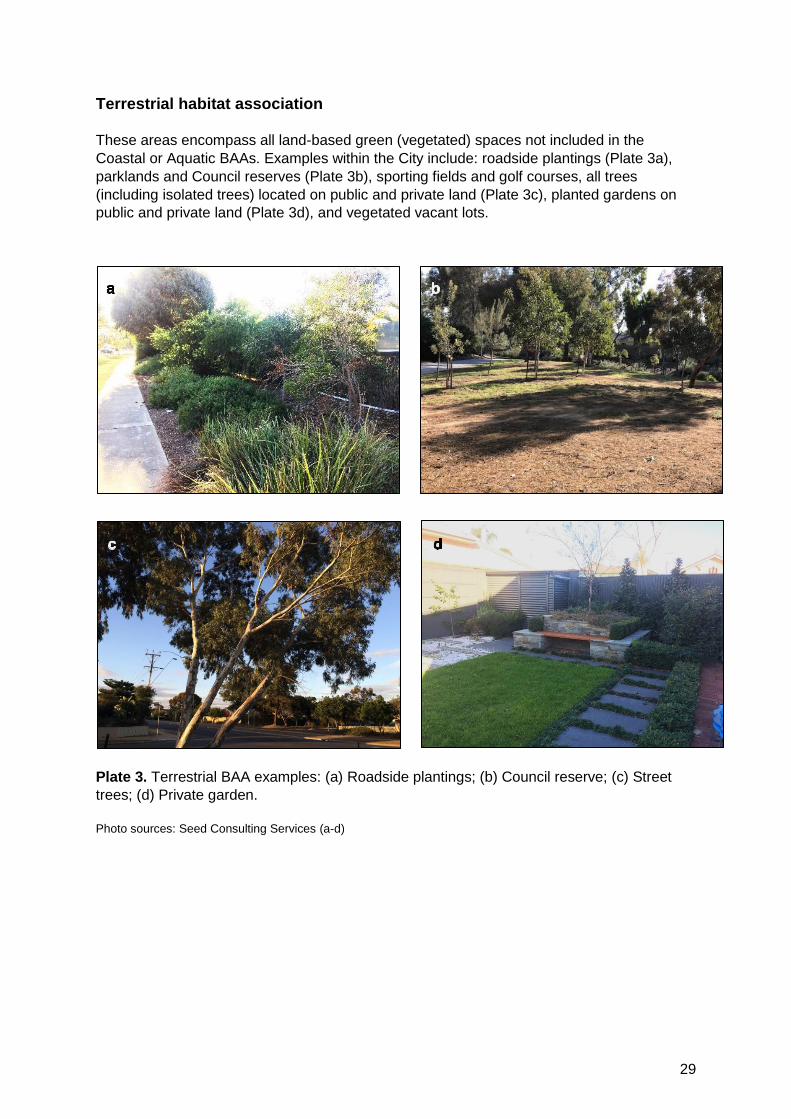
Terrestrial habitat association
These areas encompass all land-based green (vegetated) spaces not included in the
Coastal or Aquatic BAAs. Examples within the City include: roadside plantings (Plate 3a),
parklands and Council reserves (Plate 3b), sporting fields and golf courses, all trees
(including isolated trees) located on public and private land (Plate 3c), planted gardens on
public and private land (Plate 3d), and vegetated vacant lots.
Plate 3. Terrestrial BAA examples: (a) Roadside plantings; (b) Council reserve; (c) Street
trees; (d) Private garden.
Photo sources: Seed Consulting Services (a-d)

30
9.3 Attachment C. Action prioritisation scoring details
The following criteria scores were used to scoring relative prioritisation of BAA actions.
Scoring was informed through consultation with Council:
Criteria Score
Technically possible 3. Action is easy to implement
2. Action causes some problems
1. Action is not possible
Cost 3. Implementation is affordable within budgets
2. Action is affordable but may require further budgeting
1. Action is expensive. Difficult to fund in the action timeframe
Work flow impact (internal) 3. Achievable within current resources
2. May require additional resources
1. Additional resources required
Motivation of staff 3. Staff are likely to take up the action willingly
2. Staff may take up the action
1. Staff are unwilling to take up the action
Public engagement 3. Direct public engagement (on-ground/volunteering)
2. Indirect public engagement (education/awareness raising)
1. Public engagement not required
Timeframe 3. earliest completion 2020 (or requires implementation by)
2. earliest completion 2025 (or requires implementation by)
1. earliest completion 2030 (or requires implementation by)
The following table shows the scoring of the six criteria for each of the BAA actions. For
each action the score allocated for each criteria and the sum total of scores (out of a
possible 18) are shown. The sum total of scores was used to determine the relative priority
rank for each action: 16 = first priority (green); 15 = second priority (yellow); 14 = third
priority (orange); and, 13 = fourth priority (red).
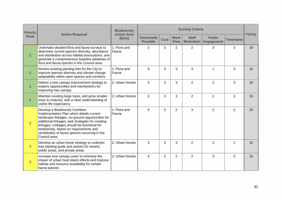
31
Priority Rank
Action Required Biodiversity Action Area
(BAA)
Scoring Criteria
TOTAL Technically
Possible Cost
Work Flow
Staff Motivation
Public Engagement
Timeframe
1
Undertake detailed flora and fauna surveys to determine current species diversity, abundance and distribution across habitat associations, and generate a comprehensive baseline database of flora and fauna species in the Council area.
1. Flora and Fauna
3 3 2 2 3 3 16
1 Review existing planting lists for the City to improve species diversity and climate change adaptability within open spaces and corridors.
1. Flora and Fauna
3 3 3 3 1 3 16
1 Deliver a tree canopy improvement strategy to explore opportunities and mechanisms for improving tree canopy
2. Urban forests 3 3 3 2 2 3 16
1 Maintain existing large trees, and grow smaller trees to maturity, with a clear understanding of useful life expectancy
2. Urban forests 3 3 3 2 2 3 16
2
Develop a Biodiversity Corridors Implementation Plan which details current landscape linkages, on-ground opportunities for additional linkages, and strategies for creating linkages. Linkages should be functional for biodiversity, based on requirements and sensitivities of fauna species occurring in the Council area.
1. Flora and Fauna
3 3 2 3 2 2 15
2 Develop an urban forest strategy to underpin tree planting goals and actions for streets, public areas, and private areas
2. Urban forests 3 3 3 2 2 2 15
2
Increase tree canopy cover to minimise the impact of urban heat island effects and improve habitat and resource availability for certain fauna species
2. Urban forests 3 2 2 2 3 3 15
32
Priority Rank
Action Required Biodiversity Action Area
(BAA)
Scoring Criteria
TOTAL Technically
Possible Cost
Work Flow
Staff Motivation
Public Engagement
Timeframe
2
Develop collaborative relationships with water management bodies and facilitate a cohesive database for water quality monitoring across the city to identify opportunities for improvement
3. Water and aquatic environments
3 3 3 3 1 2 15
2 Engage community and landowners in education programs regarding water quality on private land
3. Water and aquatic environments
3 2 3 2 3 2 15
2
Develop and undertake community biodiversity education events to inform and inspire community action. Examples of events/topics include: • Bioblitz events • Flora and fauna • Water quality • Tree benefits • Biodiversity monitoring
4. Education and citizen science
3 2 2 2 3 3 15
2
Build our knowledge through monitoring and education to understand how our activities are improving biodiversity and create systems and processes to manage the information
4. Education and citizen science
3 2 2 2 3 3 15
3 Develop management strategies to manage threats to biodiversity, including any biological threats identified in the flora and fauna surveys.
1. Flora and Fauna
3 2 2 2 3 2 14
3
Identify opportunities for the development and enhancement of new and existing aquatic environments and implement WSUD and rain gardens/filters in public parks and gardens
3. Water and aquatic environments
3 2 2 2 2 3 14
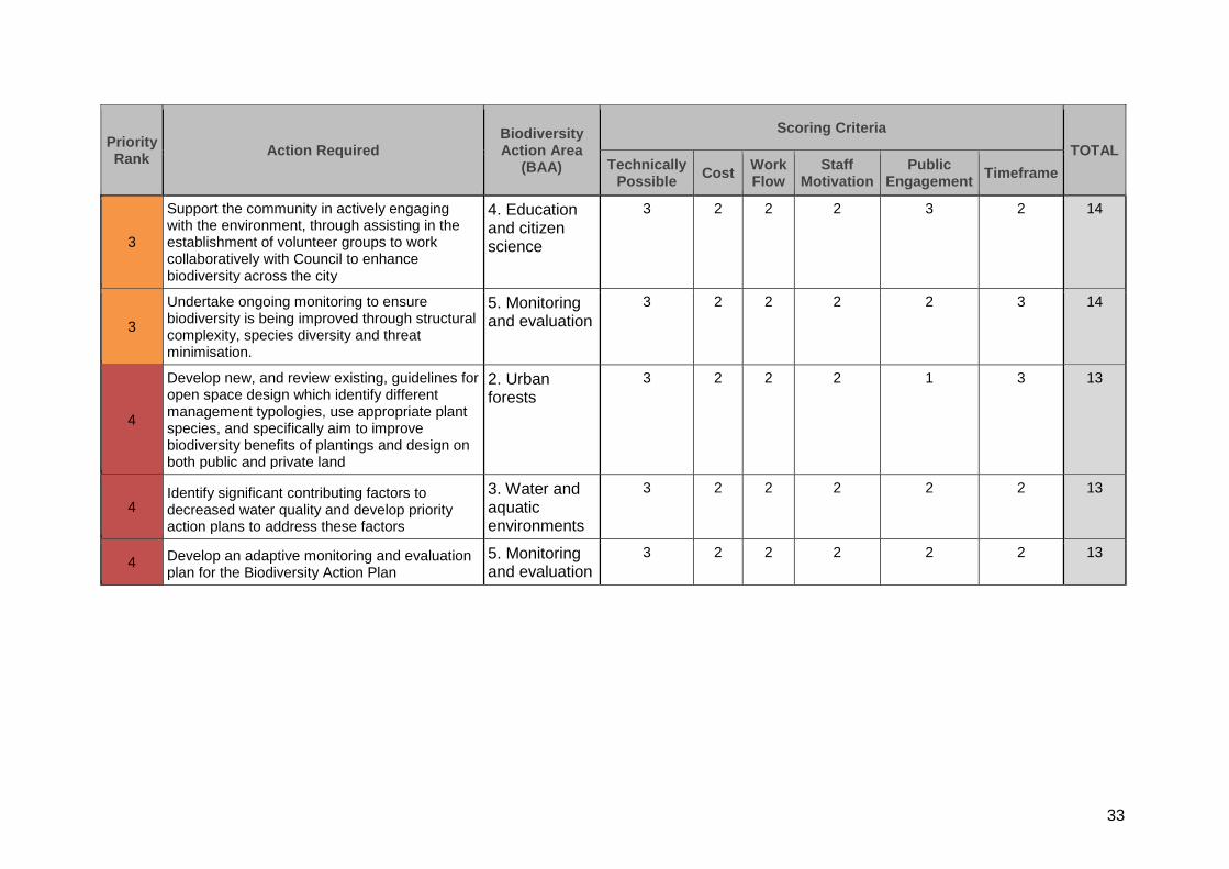
33
Priority Rank
Action Required Biodiversity Action Area
(BAA)
Scoring Criteria
TOTAL Technically
Possible Cost
Work Flow
Staff Motivation
Public Engagement
Timeframe
3
Support the community in actively engaging with the environment, through assisting in the establishment of volunteer groups to work collaboratively with Council to enhance biodiversity across the city
4. Education and citizen science
3 2 2 2 3 2 14
3
Undertake ongoing monitoring to ensure biodiversity is being improved through structural complexity, species diversity and threat minimisation.
5. Monitoring and evaluation
3 2 2 2 2 3 14
4
Develop new, and review existing, guidelines for open space design which identify different management typologies, use appropriate plant species, and specifically aim to improve biodiversity benefits of plantings and design on both public and private land
2. Urban forests
3 2 2 2 1 3 13
4 Identify significant contributing factors to decreased water quality and develop priority action plans to address these factors
3. Water and aquatic environments
3 2 2 2 2 2 13
4 Develop an adaptive monitoring and evaluation plan for the Biodiversity Action Plan
5. Monitoring and evaluation
3 2 2 2 2 2 13


