38
© Biosis September 2012 – Leading ecology and heritage consultants 1 Biodiversity Assessment: 92 Elizabeth Avenue, Rosebud West Final Report Prepared for Beveridge Williams 28 April 2014

© Biosis September 2012 – Leading ecology and heritage consultants 1
Biodiversity Assessment:
92 Elizabeth Avenue, Rosebud West Final Report
Prepared for Beveridge Williams
28 April 2014
© Biosis 2012 – Leaders in Ecology and Heritage Consulting www.biosis.com.au II
Biosis Pty Ltd
This document is and shall remain the property of Biosis Pty Ltd. The document may only be used
for the purposes for which it was commissioned and in accordance with the Terms of the
Engagement for the commission. Unauthorised use of this document in any form whatsoever is
prohibited.
Disclaimer:
Biosis Pty Ltd has completed this assessment in accordance with the relevant federal, state
and local legislation and current industry best practice. The company accepts no liability for
any damages or loss incurred as a result of reliance placed upon the report content or for
any purpose other than that for which it was intended.
Biosis offices
AUSTRALIAN CAPITAL TERRITORY
Canberra
Floor 1, Unit 3, 38 Essington Street
Mitchell ACT 2911
Phone: (02) 6241 2333
Fax: (03) 9646 9242
Email: [email protected]
NEW SOUTH WALES
Sydney
Unit 14 17-27 Power Avenue
Alexandria NSW 2015
Phone: (02) 9690 2777
Fax: (02) 9690 2577
Email: [email protected]
Wollongong
8 Tate Street
Wollongong NSW 2500
Phone: (02) 4229 5222
Fax: (02) 4229 5500
Email: [email protected]
QUEENSLAND
Brisbane
Suite 4 First Floor, 72 Wickham Street
Fortitude Valley QLD 4006
Phone: (07) 3831 7400
Fax: (07) 3831 7411
Email: [email protected]
VICTORIA
Ballarat
506 Macarthur Street
Ballarat VIC 3350
Phone: (03) 5331 7000
Fax: (03) 5331 7033
Email: [email protected]
Melbourne (Head Office)
38 Bertie Street
Port Melbourne VIC 3207
Phone: (03) 9646 9499
Fax: (03) 9646 9242
Email: [email protected]
Wangaratta
16 Templeton Street
Wangaratta VIC 3677
Phone: (03) 5721 9453
Fax: (03) 5721 9454
Email: [email protected]
Document information
Report to: Beveridge Williams
Prepared by: Steve Mueck
Daniel Gilmore
Biosis project no.: 16893
File name: 16893ElizabethDrF&Ffinalreport16042014 .docx
Citation: Biosis 2014. Biodiversity Assessment: 92 Elizabeth Avenue,
Rosebud West. Report for Beveridge Williams. Authors: Mueck, S. &
Gilmore, D. Biosis Pty Ltd, Melbourne. Project no. 16893.
Document control
Version Internal review Date issued
Draft version 01 JY 21/03/14
Final version 01 SGM 28/04/14
Acknowledgements
Biosis acknowledges the contribution of the following people and
organisations in undertaking this study:
• Beveridge Williams: Bernard Stewart
• Department of Environment & Primary Industries for
access to the Victorian Biodiversity Atlas
The following Biosis staff were involved in this project:
• Clare McCutcheon & Tony Steelcable, assistance in the field
• Sally Mitchell, mapping

© Biosis 2012 – Leaders in Ecology and Heritage Consulting III
Contents
Summary ................................................................................................................................................................. V
1. Introduction .................................................................................................................................................... 1
1.1 Project background ......................................................................................................................................................... 1
1.2 Scope of assessment ...................................................................................................................................................... 1
1.3 Location of study area .................................................................................................................................................... 1
2. Methods ........................................................................................................................................................... 3
2.1 Literature and database review ................................................................................................................................... 3
2.2 Definitions of significance .............................................................................................................................................. 3
2.2.1 Species and ecological communities............................................................................................................ 3
2.2.2 NaturePrint areas ............................................................................................................................................. 4
2.3 Likelihood of presence for significant species .......................................................................................................... 4
2.4 Site investigation.............................................................................................................................................................. 4
2.4.1 Flora assessment .............................................................................................................................................. 4
2.4.2 Fauna assessment ............................................................................................................................................ 5
2.4.3 Permits ................................................................................................................................................................ 6
2.5 Qualifications .................................................................................................................................................................... 6
2.6 Legislation and policy ..................................................................................................................................................... 6
2.7 Mapping............................................................................................................................................................................. 7
3. Results .............................................................................................................................................................. 8
3.1 Vegetation & fauna habitat ........................................................................................................................................... 8
3.2 Landscape context ....................................................................................................................................................... 11
3.3 Significant species and ecological communities ................................................................................................... 11
3.3.1 EPBC Act, FFG Act & DSE Advisory listed species .................................................................................... 11
3.3.2 Significant ecological communities ............................................................................................................ 12
3.4 Other ecological values ............................................................................................................................................... 13
3.5 Further survey recommendations ........................................................................................................................... 13
4. Biodiversity Legislation and Government Policy ................................................................................... 14
4.1 Commonwealth ............................................................................................................................................................ 14
4.1.1 Environment Protection and Biodiversity Conservation Act 1999 ..................................................... 14
4.2 State ................................................................................................................................................................................. 15
4.2.1 Flora and Fauna Guarantee Act 1988 (FFG Act) ...................................................................................... 15
4.2.2 Catchment and Land Protection Act 1994 (CaLP Act) ............................................................................ 15
4.2.3 Planning and Environment Act 1987 (incl. Planning Schemes) ........................................................... 15
4.2.4 Wildlife Act 1975 and associated Regulations ......................................................................................... 17
4.2.5 Environmental Effects Act ............................................................................................................................ 17

© Biosis 2012 – Leaders in Ecology and Heritage Consulting IV
4.2.6 Water Act 1989 ............................................................................................................................................... 18
4.2.7 Environment Protection Act 1970: State Environmental Protection Policy (Waters of Victoria) 2003
........................................................................................................................................................................... 18
4.2.8 Revegetation Plan Enforcement Order ..................................................................................................... 18
5. Victoria's Biodiversity Assessment Guidelines ....................................................................................... 21
5.1 Site based information ................................................................................................................................................ 21
5.1.1 Habitat Hectares ............................................................................................................................................ 22
5.2 Landscape scale information ..................................................................................................................................... 23
5.2.2 Strategic biodiversity score .......................................................................................................................... 23
5.2.3 Habitat importance score ............................................................................................................................ 23
5.3 Proposed removal of native vegetation .................................................................................................................. 23
5.3.2 Determining the risk-based pathway ........................................................................................................ 23
5.4 Offsetting the loss of native vegetation ................................................................................................................... 25
5.4.2 Specific-general offset test .......................................................................................................................... 25
5.4.3 General offsets ............................................................................................................................................... 25
5.4.4 Suitability for On-site offsets ....................................................................................................................... 27
5.4.5 Offset Potential .............................................................................................................................................. 28
6. Key Ecological Values and Recommendations........................................................................................ 29
References ............................................................................................................................................................. 31
Appendices ............................................................................................................................................................ 32
List of Figures
Figure 1: Location of the Elizabeth Avenue study area, Rosebud West, Victoria ........................................... 2
Figure 2: Ecological features of the study area, 92 Elizabeth Ave, Rosebud West, Victoria .......................... 9
Figure 3: Impact on native vegetation by the proposed development footprint, Elizabeth Avenue,
Rosebud West. ....................................................................................................................................................... 26
List of Tables
Table 1: Criteria for determining significance of species & ecological communities ..................................... 3
Table 2: Summary of significant species most likely to occur in the study area .......................................... 12
Table 3: Assessment of project in relation to the EPBC Act ............................................................................ 14
Table 4: Habitat hectares of native vegetation within the study area ........................................................... 22
Table 5: Strategic biodiversity scores of habitat zones proposed for clearing within the study area ....... 23
Table 6: Habitat importance scores of Biodiversity Class Areas within the study area* ............................ 24
Table 7: Summary of habitat hectares to be removed .................................................................................... 24
Table 8: Summary of key ecological values, potential implications of developing the study area and
recommendations to minimise ecological impacts during the design phase .............................................. 30

© Biosis 2012 – Leaders in Ecology and Heritage Consulting V
Summary
Biosis Pty Ltd was commissioned by Beveridge Williams, acting on behalf of Watermark Village Pty Ltd, to
undertake a flora and fauna assessment of an area of land proposed for residential development at 92
Elizabeth Avenue, Rosebud West. The study area is located approximately 65 km south of the Melbourne
CBD. It encompasses approximately 29.84 ha of private land currently zoned Residential 1 in the north with
the balance zoned Special Use Zone 4 and Public Use Zone 4.
Ecological values
Key ecological values identified within the study area are as follows:
• 23.98 ha of native vegetation. While the vegetation closest to Elizabeth Avenue is the most modified
all of the wetland vegetation present is generally in good to excellent condition.
• Three Ecological Vegetation Classes (EVCs) were recorded:
Tall Marsh (EVC 821), Brackish Wetland (EVC 656) and Aquatic Herbland (EVC 653).
• All three EVCs recorded are considered to be endangered within the Gippsland Plain bioregion.
• The site supports habitat for two wetland birds listed under the EPBC Act and 10 birds listed as
threatened in Victoria, and also provides habitat for 39 migratory species listed under the EPBC Act.
• NaturePrint identifies part of the site as providing high contribution of natural values with other parts
providing lower contribution although still at the high end of the scale.
• The native vegetation within the study area is contiguous with broader areas of native wetland
vegetation to the south and east and forms part of the broader Tootgarook Swamp.
Government legislation and policy
An assessment of the project in relation to key biodiversity legislation and policy is provided and summarised
below.
Legislation /
Policy
Relevant ecological
feature on site
Permit / Approval
required
Notes
EPBC Act Habitat for threatened
species and migratory
species
Referral
recommended
Referral provides a risk mitigation
measure for the project
FFG Act Site provides habitat
for numerous FFG
listed species
Protected Flora
Permit not required
Site is private land
Planning &
Environment
Act
Indigenous vegetation
to be cleared
Planning permit
required, including
permission to lop or
remove native
vegetation.
Permit application needs to outline
requirements identified in the Biodiversity
Assessment Guidelines and Handbook
Permit application needs to address
provisions of ESO 19.
Permitted clearing of native vegetation will
require prescribed offsets to be secured
prior to project commencement
CaLP Act Eight noxious weeds
recorded
Not applicable
Comply with any requirements to
control/eradicate noxious weeds
Note: Guidance provided in this report does not constitute legal advice.

© Biosis 2012 – Leaders in Ecology and Heritage Consulting VI
Permitted clearing of native vegetation - Biodiversity assessment guidelines (the Guidelines)
An assessment of the project against the Guidelines is provided below*:
Guidelines Outcome Notes
Location risk Location A Entire site is Location A
Native vegetation removal
extent 2.629 ha Four sections of two habitat Zones
Risk-based pathway Moderate Based on more than 1 ha of clearing
Habitat hectares to be
removed 1.720
1.125 of Brackish Wetland and 0.595 of Tall
Marsh
Strategic Biodiversity Score 0.722 – 0.832 Four separate areas from two patches impacted
Modelled habitat for rare or
threatened species
Important habitat
present for 30 species
modelled
15 wetland birds, 4 raptors, 4 plants, 2 frogs, 2
skinks, 1 fish, Orange-bellied Parrot and Grey
Headed Flying-fox
Specific-general offset test
result General
No habitat loss exceeds the specific offset
threshold
General/Specific
Biodiversity Equivalence
Scores
0.002 – 0.812 The largest patch has the highest General
Biodiversity Equivalence Scores (GBES)
Offset type General
The onsite offset area is capable of generating
both general and specific offsets
Offset risk factor 1.5
Offset amount: General
Biodiversity Equivalence
Units (GBEU)
1.909 The onsite offset site can generate 6.325 GBEU,
providing an excess of 4.416 GBEU
Offset habitat for species Numerous species with
dispersed
Proposed first party offset area can provide both
general and specific offsets
Offset Vicinity Port Phillip &
Westernport CMA
(PPWCMA)
The proposed offset site is within the PPWCMA
Offset minimum Strategic
Biodiversity Score (SBS) 0.589
The proposed on-site offset supports native
vegetation with a SBS between 0.742 and 0.892
* outputs provided by DEPI native vegetation support team
The required general offset could be generated through management of native vegetation retained within
the study area. This would provide a 'first party' offset and would require the appropriate vegetation security
agreements and a 10 year offset management plan. Alternatively, the applicant may seek to purchase 'third
party' specific offset credits via an accredited trading scheme.
A total of 6.325 General Biodiversity Equivalence Units could be generated through management of
vegetation on site. This is well in excess of the 1.909 Biodiversity Equivalence Units required for the proposed
clearing.

© Biosis 2012 – Leaders in Ecology and Heritage Consulting VII
The proponent is responsible for sourcing and legal protection of offset sites in perpetuity and funding
management of those sites for the initial 10 years.
Recommendations and Discussion
The results of this assessment should be incorporated into the project design, by adding the flora and fauna
mapping information into the planning maps and investigating options to retain as much of the mapped
vegetation/habitats as possible.
Future requirements for infrastructure and services must be forecast as much as possible at this time and
allowance made outside any nominated reserves for all construction works. This includes road batters,
footpaths, drainage and services (including optic fibre). All areas of vegetation/habitat nominated in the
design plan as 'retained' are to be treated as no-go zones and are not to be encroached upon as
development progresses.
Development design has incorporated a single fronted road as an interface between residential lots and
retained native vegetation. This is considered an essential design component for the ongoing management
of any retained native vegetation.
Establishing stormwater treatment areas within land not mapped as native vegetation to the south of the
proposed development footprint is considered appropriate. These areas are dominated by exotic vegetation
and support both a low cover and low diversity of native plant species.
Vegetation losses are unavoidable for the development as proposed and offsets are required under the
Biodiversity Assessment Guidelines (as summarised above).
The proposed offset area has the potential to generate significantly more Biodiversity Equivalence Units than
required to satisfy the requirements of the proposed clearing. These offset can be sold to other developers
to satisfy both general and specific offset requirements.
It is unlikely that the area of Public Use Zone 4, and the property to the south east of this zone, in the south
eastern corner of the property (about 1.4 ha) would be eligible for classification as an offset site. This would
result in a small decrease in the offset potential of the proposed offset area (i.e. the balance of the property
outside the proposed development footprint).
A VCAT Enforcement Order was issued in 2011for illegal vegetation clearance at the site. This Enforcement
Order requires the preparation of a Re-vegetation Plan.
Given the extent and duration of inundation observed in association with the Biosis assessments, it is
considered unlikely that any recent clearing activities (i.e. within the last 5 years) have had a significant impact
on the species composition of these wetlands. The wetland vegetation present appears to occupy all areas
typically subject to periodic inundation. As a result no direct revegetation works are considered necessary as
the site has regenerated naturally. However the disturbance may exacerbate weed invasion and therefore
Biosis would recommend weed control works targeting invasive exotic species. Any weed control works
within the wetland vegetation would only need to be limited in extent as these wetland communities support
quite low weed levels when inundated. However, the control of invasive exotic wetland species such as
Jointed Rush Juncus articulatus and Spiny Rush Juncus acutus, which are currently relative rare on site would be
ecologically beneficial as these species have the potential to dominated parts of the site and otherwise
exclude indigenous wetland species.
The site has the potential to provide a first party offset for the proposed development.

© Biosis 2012 – Leaders in Ecology and Heritage Consulting 1
1. Introduction
1.1 Project background
Biosis Pty Ltd was commissioned by Beveridge Williams, acting on behalf of Watermark Village Pty
Ltd, to undertake a flora and fauna assessment of land proposed for residential subdivision at
92 Elizabeth Avenue, Rosebud West.
1.2 Scope of assessment
The objectives of this investigation are to:
• Describe the vascular flora (ferns, conifers, flowering plants) and vertebrate fauna (mammals,
birds, reptiles, frogs, fishes)
• Map native vegetation and other habitat features
• Conduct a vegetation quality assessment
• Assess the potential for the site to support threatened species
• Review the implications of relevant biodiversity legislation and policy, including Victoria’s
Permitted clearing of native vegetation - Biodiversity assessment guidelines, 2013
• Identify potential implications of the proposed development and provide recommendations
to assist with development design
• Recommend any further assessments of the site that may be required (such as targeted
searches for significant species).
1.3 Location of study area
The study area is located in Rosebud West approximately 65 km south of the Melbourne CBD
(Figure 1). It encompasses approximately 29.84 ha of private land known as 92 Elizabeth Avenue,
Rosebud West. It is currently zoned Residential 1 in the north with the balance zoned Special Use
Zone 4 and Public use Zone 4.
The study area is within the:
• Gippsland Plain Bioregion
• Bunyip River Basin
• Management area of Melbourne Water and/or the Port Phillip and Westernport Catchment
Management Authority (CMA)
• Shire of Mornington Peninsula.

!
!
RosebudWest
Rosebud
MORNINGTONMORNINGTONPENINSULAPENINSULA
SHIRESHIREChina
man s
C reek
Dr umDrum Alloc Creek
Port Phillip Bay
Third
Av
Colchester Rd
Bank
sia Pl
John St
Mccombe St
Besgrove St
Cain St
Allambi AvDenholm St
Ibis Gr
Cairns Av
Guest St
Darva
ll St
Kuringai Rd
Morri
s St
Hiscock Rd
Johnson St
White
head
Gr Seco
nd Av
Clematis Av
Tarwarri AvMaine St
Kevin
St
Brendel St
Wynne St
Balak
a Ct
Melville St
Four
th Av
Swans Way
Hakea Av
Park Av
Jennin
gs Ct
Clubhouse Dr
Iris Cl
Bay Trl
Highbury Rd
Ella Cr
Hinton
St
Dullard St
Coleman CrKeith
St
Mawarra Av
Innes Ct
Teal St
Tern Av
Grenfell Way
WindellaAv
Yolland St
Kingfisher Av
Kareela Dr
Hillcre
stDr
Hope St
Bone
o Rd
Grenville Gr
Williamson St
Woyna Av
Alma StVincent St
Bella Vista DrDavid Ct
Balak
a St
Doig
Av
Eleventh Av
Vale
St
Peter Thomson Dr
Wyuna St
Tham
er St
Whyte StTerry St
Monic a St
Point Nepean Rd Capel Av
Mcalpin St
Wilkinson St
Bona St
Kolinda Cr
Panorama Dr
Marks Av
Barry St
Tom Maw Memorial Dr
Eliza
beth
Av
Booran Pde
Howqua Dr
Curlew Dr
Warranilla Av
Plain
St
Barra
gowa
Dr
Belar Rd
Lockhart Dr
Chatfield Av
Fifth
Av
Thom
as St
Ruyton Dr
Fleur AvOl
dCap
eSch
anck
Rd
Ashenden
Sq
Flamingo Rd
Point Nepean Rd
Bone
o Rd
Point Nepean Rd
Eastbourne Rd
Bone
o Rd
Elizab
eth Av
Broadway
Browns RdBrowns Rd
Old Ca
pe Sc
hanc
k Rd
Truemans Rd
Tr uem
a ns R
d
Bone
o Rd
Mornington Peninsula Fwy
Acknowledgement:VicMap© State of Victoria,
Matter: 16893,Date: 26 February 2014,Checked by: SGM, Drawn by: SKM, Last edited by: smitchellLocation:P:\16800s\16893\Mapping\16893_Fig1_Locality.mxd
LegendStudy Area
Scale 1:25,000 @ A4, GDA 1994 MGA Zone 55
0 240 480 720 960
Metres ±Biosis Pty LtdBallarat, Brisbane, Canberra, Melbourne, Sydney, Wangaratta & Wollongong
Figure 1: Location of the Study Area -92 Elizabeth Avenue, Rosebud West, Victoria
!
!
!
!!
!
!
!
Melbourne
Dandenong
MelbourneWerribee
Frankston
Lilydale
Pakenham
© Biosis 2012 – Leaders in Ecology and Heritage Consulting 3
2. Methods
2.1 Literature and database review
In order to provide a context for the study site, information about flora and fauna from within 5 km
of the study area (the ‘local area’) was obtained from relevant public databases. Aquatic fauna
records were searched for the Bunyip basin/catchment. Records from the following databases were
collated and reviewed:
• Flora Information System which includes records from the Victorian Biodiversity Atlas
‘VBA_FLORA25, FLORA100 & FLORA Restricted’ August 2012 © The State of Victoria,
Department of Environment and Primary Industries (DEPI). The contribution of the Royal
Botanical Gardens Melbourne to the database is acknowledged
• Victorian Biodiversity Atlas ‘VBA_FAUNA25, FAUNA100 & FAUNA Restricted’ August 2012 ©
The State of Victoria
• DEPI Biodiversity Interactive Map (BIM)
• BirdLife Australia, the New Atlas of Australian Birds 1998-2012 (BA)
• Protected Matters Search Tool of the Australian Department of the Environment for matters
protected by the Environment Protection and Biodiversity Conservation Act 1999 (EPBC Act)
• Melbourne Water Fish database (MWF)
Other sources of biodiversity information:
• DEPI NaturePrint; accessed through the Biodiversity Interactive Map
• Biosis records that have been submitted to DSE and Melbourne Water but do not yet appear
on the VBA, FIS or MWF)
2.2 Definitions of significance
2.2.1 Species and ecological communities
The significance of a species or community is determined by its listing as rare or threatened under
Commonwealth or State legislation / policy. The sources used to categorise significance of species
and communities in this report are summarised below in Table 1.
Table 1: Criteria for determining significance of species & ecological communities
Significance
National Listed as threatened (critically endangered, endangered, vulnerable or conservation
dependent) under the Environment Protection and Biodiversity Conservation Act
1999
State Listed as threatened (critically endangered, endangered, vulnerable) or rare for flora
species, in Victoria on a DEPI Advisory List (DSE 2005, 2013a)
Listed as threatened under the Flora and Fauna Guarantee Act 1988

© Biosis 2012 – Leaders in Ecology and Heritage Consulting 4
Flora species recorded from a small percentage of sites in the bioregion are considered to be
significant in the bioregion and are identified in the list of flora species recorded in the study area
provided in Appendix 1. These species are not discussed further in this report.
Fauna species listed as near threatened or data deficient are listed in Appendix 2, however in
accordance with advice from DSE these fauna species are not considered to be at the same level of
risk as higher categories of threat. These species are generally not discussed in detail in this report.
2.2.2 NaturePrint areas
Areas of conservation significance were formerly documented in the DSE Biodiversity Interactive Map
as Biosites ranked as significant at national, state and regional levels. DEPI have advised that the
Biosite reports are obsolete and their replacement layer on the Biodiversity Interactive Map is now
NaturePrint which identifies the relative contribution of sites to protecting the full range of
biodiversity values in Victoria.
2.3 Likelihood of presence for significant species
The models of advisory listed species (DEPI 2005, 2013) distribution produced by DEPI provide the
basis for assessment of biodiversity importance when quantifying native vegetation that is proposed
to be removed. The models are constructed using state-level explanatory variables and limitations
with accuracy should be considered as such for site-level assessments.
The likelihood of species which are identified by the Protected Matters Search Tool (PMST) (i.e. EPBC
Act listed species) or other EPBC Act listings either recorded or considered as having a high likelihood
of presence within the site, is ranked as negligible, low, medium or high. The likelihood of occurrence
is a broad categorisation used by Biosis to indicate the potential for a species to occur within the
study area. It is based on expert opinion and implies the relative value of a site for a particular
species. The rationale for the rank assigned is provided for each species in Appendix 1 (flora) and
Appendix 2 (fauna).
Species which have at least medium likelihood of occurrence are given further consideration in this
report. The need for targeted survey for these species is also considered.
Only those species listed under the EPBC Act or listed as threatened under the FFG Act (hereafter
referred to as 'listed species') are assessed to determine their likelihood of occurrence. The habitat
value for species listed on the DEPI Advisory Lists is calculated by the Habitat Importance Modelling
produced by DEPI (DEPI 2013a). Where DEPI Advisory list species are recorded in the study area this
is noted.
2.4 Site investigation
2.4.1 Flora assessment
The flora assessment was undertaken on 23 December 2013 and 21 January 2014 and a list of flora
species was collected (# T25391). This list will be submitted to DEPI for incorporation into the
Victorian Biodiversity Atlas. Planted species have not been recorded unless they are naturalised.
Native vegetation is defined in the Victoria Planning Provisions as 'plants that are indigenous to
Victoria, including trees, shrubs, herbs and grasses' (Clause 72).

© Biosis 2012 – Leaders in Ecology and Heritage Consulting 5
Victoria’s Permitted clearing of native vegetation: Biodiversity assessment guidelines classify native
vegetation into two categories (DEPI 2013a):
• A remnant patch of native vegetation (measured in hectares) is either:
– An area of native vegetation, with or without trees, where at least 25 percent of the total
perennial understorey cover is native plants.
– An area with three or more indigenous canopy trees where the tree canopy cover is at least
20 percent.
Remnant patch vegetation is classified into ecological vegetation classes (EVCs). An EVC contains one
or more floristic (plant) communities, and represents a grouping of broadly similar environments.
Definitions of EVCs and benchmarks (condition against which vegetation quality at the site can be
compared) are determined by DEPI.
• A scattered tree is defined as (extent measured by number of trees):
– An indigenous canopy tree that does not form part of a remnant patch of native
vegetation.
A canopy tree is a mature tree that is greater than three metres in height and is normally found in the
upper layer of a vegetation type. Ecological vegetation class descriptions provide a list of the typical
canopy species. A condition score and extent is applied to each scattered tree based on information
provided by DEPI's NVIM.
A Vegetation Quality Assessment was undertaken for all remnant patch native vegetation identified in
the study area. This assessment is consistent with DEPI's Habitat Hectare method (DSE 2004) and the
Guidelines (DEPI 2013a). For the purposes of this assessment the limit of the resolution for the
habitat hectare assessment process is taken to be 0.001 habitat hectares (Hha). That is, if native
vegetation is present with sufficient cover but its condition and extent would not result in the
identification of at least 0.001 habitat hectare then that vegetation will not be mapped or assessed as
a separate habitat zone.
Where relevant, notes were made on specific issues such as noxious weed infestations, evidence of
management works, current grazing impacts and the regeneration capacity of the vegetation.
Species nomenclature for flora follows the Flora Information System (FIS). Classification of native
vegetation is based on ecological vegetation classes (EVCs). An EVC contains one or more floristic
(plant) communities, and represents a grouping of broadly similar environments. Definitions of EVCs
and benchmarks (condition against which vegetation quality at the site can be compared) are as
determined by DEPI.
2.4.2 Fauna assessment
The study area was investigated on 9 October and 24 December 2013 to determine its values for
fauna. These were determined primarily on the basis of the types and qualities of habitat(s) present.
All species of fauna observed during the assessment were noted and active searching for fauna was
undertaken. This included direct observation, searching under rocks and logs, examination of tracks
and scats and identifying calls. Particular attention was given to searching for significant species and
their habitats. Fauna species were recorded with a view to characterising the values of the site and
the investigation was not intended to provide a comprehensive survey of all fauna that has potential
to utilise the site over time.

© Biosis 2012 – Leaders in Ecology and Heritage Consulting 6
The investigation of fauna incorporated surveys for aquatic fauna although these aquatic surveys are
documented separately (Biosis 2014). The survey results are outlined in Appendix 2. Fauna records
will be submitted to DSE for incorporation into the Victorian Biodiversity Atlas.
2.4.3 Permits
Biosis undertakes flora and fauna assessments under the following permits and approvals:
• Research Permit/Management Authorisation and Permit to Take Protected Flora & Protected
Fish issued by the Department of Environment and Primary Industries under the Wildlife Act
1975, Flora and Fauna Guarantee Act 1988 and National Parks Act 1975 (Permit number
10006240, expiry date 9 May 2015)
• Approvals 04.12 and 14.12 from the Wildlife and Small Institutions Animal Ethics Committee
2.5 Qualifications
Ecological surveys provide a sampling of flora and fauna at a given time and season. There are a
number of reasons why not all species will be detected at a site during survey, such as low
abundance, patchy distribution, species dormancy, seasonal conditions, and migration and breeding
behaviours. In many cases these factors do not present a significant limitation to assessing the
overall biodiversity values of a site.
The current flora and fauna assessment was conducted in spring and summer, which is an optimal
time for such surveys. However the site is relatively large and access was made difficult due to
extensive levels of site inundation and the presence of dense vegetation.
Biodiversity Assessment Reports (BAR) and Biodiversity Impact Offset Requirement (BIOR) reports are
prepared through DEPI's NVIM system or requested through DEPI's Native Vegetation Transitional
Support team. Biosis supplies relevant site-based spatial information as inputs to DEPI. We are
entirely reliant on DEPI's output reports for moderate and high risk pathway applications, and for low
risk pathway applications with complex mapping requirements. Biosis makes every effort to ensure
site and spatial information entered into the NVIM, or supplied to DEPI, is an accurate reflection of
proposed native vegetation removal. The DEPI BOIR can be viewed in Appendix 2.
2.6 Legislation and policy
The implications for the project were assessed in relation to key biodiversity legislation and policy
including:
• Matters listed under the Environment Protection and Biodiversity Conservation Act 1999 (EPBC
Act); associated policy statements, significant impacts guidelines, listing advice and key
threatening processes
• Threatened taxa, communities and threatening processes listed under Section 10 of the Flora
& Fauna Guarantee Act 1988 (FFG Act); associated action statements and listing advice
• Victoria’s Biodiversity Assessment Guidelines (DEPI 2013)
• Planning and Environment Act 1987 – specifically Clauses 12.01-2, 52.17 and 66.02 and
Overlays in the relevant Planning Scheme
• Noxious weeds and pest animals lists under the Catchment and Land Protection Act 1994 (CaLP
Act)

© Biosis 2012 – Leaders in Ecology and Heritage Consulting 7
• Wildlife Act 1975 and associated Regulations
• Water Act 1989
• Environment Protection Act 1970: State Environmental Protection Policy (Waters of Victoria)
2003.
2.7 Mapping
Mapping was conducted using hand-held (uncorrected) GPS units (WGS84) and aerial photo
interpretation. The accuracy of this mapping is therefore subject to the accuracy of the GPS units
(generally ± 7 metres) and dependent on the limitations of aerial photo rectification and registration.
Mapping has been produced using a Geographic Information System (GIS). Electronic GIS files which
contain our flora and fauna spatial data are available to incorporate into design concept plans.
However this mapping may not be sufficiently precise for detailed design purposes.

© Biosis 2012 – Leaders in Ecology and Heritage Consulting 8
3. Results
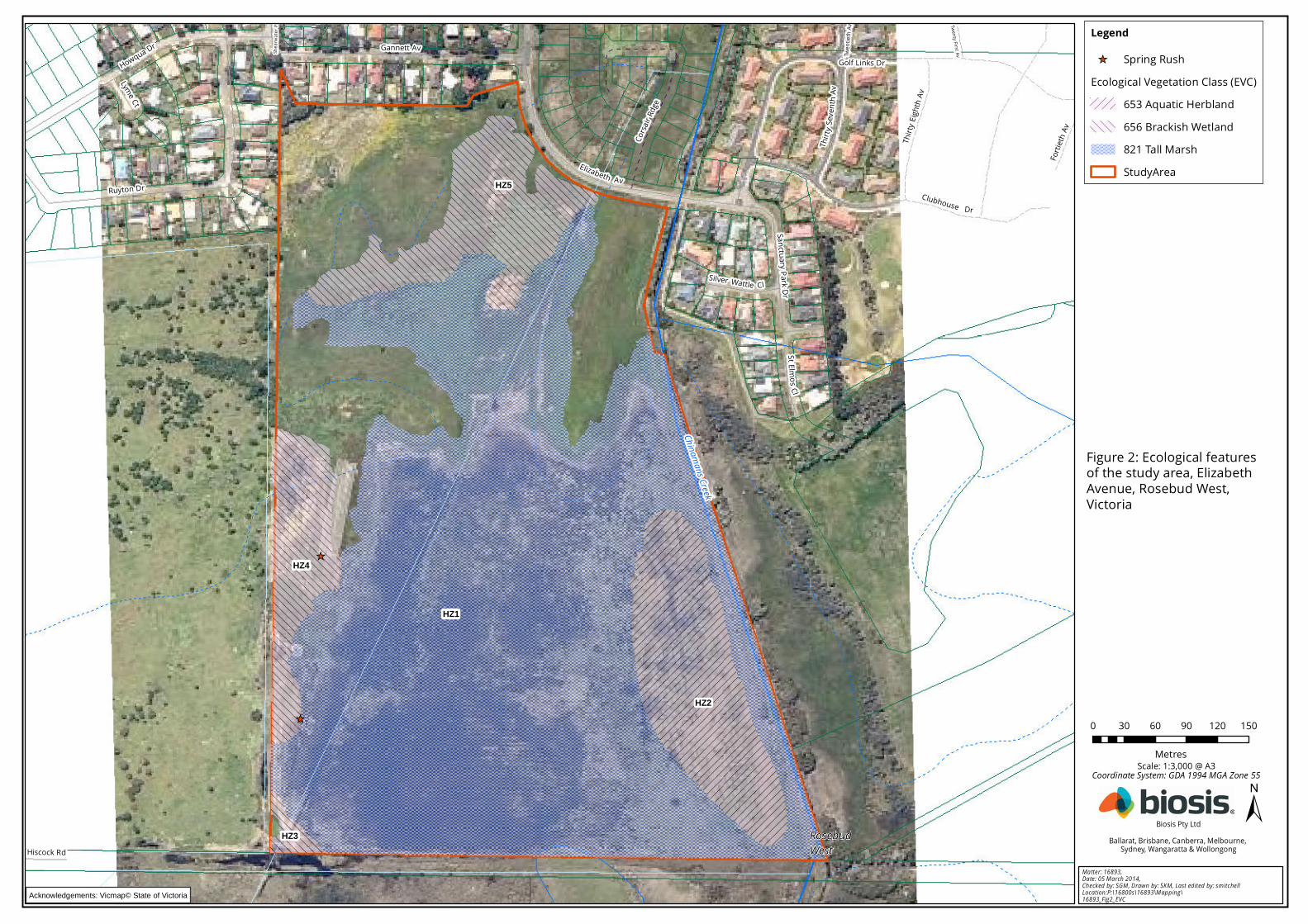
The ecological features of the study area are described below and mapped in Figure 2.
Species recorded during the flora and fauna assessment are listed in Appendix 1 (flora) and Appendix
2 (fauna). Unless of particular note, these species are not discussed further.
Significant species recorded or predicted to occur in the local area are also listed in the appendices,
along with an assessment of the likelihood of each species occurring within the study area.
For this site DEPI has stated that impacts would be below the specific-general offset test threshold for
rare or threatened species habitat (Appendix 3).
3.1 Vegetation & fauna habitat
The terrestrial vegetation and fauna habitat throughout the study area has been highly modified by
past disturbances which have included clearing, development for agriculture and weed invasion.
Terrestrial environments within the study area have been significantly degraded and support
predominantly introduced vegetation that is of limited value for native fauna. Very few indigenous
species were recorded from non-wetland environments within the study area.
The study area supports a range of ecological features including a significant wetland (supporting
three EVCs), including both ephemeral and semi-permanent wetlands. When inundated the wetland
is dominated by native vegetation including areas of Tall Marsh (EVC 821), Aquatic Herbland (EVC 653)
and Brackish Wetland (EVC 656). These ecological vegetation classes are described below:
Tall Marsh EVC 821 (endangered within the Gippsland Plain Bioregion)
This EVC occupies most of the study area (Figure 2, Plate 1). It is dominated by Common Reed
Phragmites australis to about two metres in height with smaller areas of Narrow-leaf Cumbungi Typha
domingensis. During January 2014 water levels had either recently subsided or were typically less
than 50 cm in depth. Other common ground cover species included Red Water-milfoil Myriophyllum
verrucosum, Small River Buttercup Ranunculus amphitrichus, Swamp Raspwort Haloragis brownii,
Common Water-ribbons Triglochin procera, Common Blown-grass Lachnagrostis filiformis, Swamp
Sedge Carex gunniana and Common Spike-sedge Eleocharis acuta.
Brackish Wetland EVC 656 (Endangered within the Gippsland Plain Bioregion)
This EVC occupies relatively small sections in the north and south of the study area (Figure 2, Plate 2).
It is dominated by Salt Club-sedge Bolboschoenus caldwellii to about one metre in height with smaller
areas dominated by Common Spike-sedge Eleocharis acuta and Streaked Arrowgrass Triglochin striata.
A few tussocks of Coast Saw-sedge Gahnia trifida are present. During January 2014 much of this
environment did not support any surface water but the ground was still relatively moist. Other
common ground cover species included Small River Buttercup Ranunculus amphitrichus, Swamp
Raspwort Haloragis brownii, Common Blown-grass Lachnagrostis filiformis, Large Bindweed Calystegia
sepium and Small Loosestrife Lythrum hyssopifolia.
Aquatic Herbland EVC 653 (Endangered within the Gippsland Plain Bioregion)
This EVC occupies an area in close proximity to Chinamans Creek which forms the eastern boundary
of the study area. It is dominated by Common Water-ribbons Triglochin procera with areas of open
water supporting floating mats of Floating Pondweed Potamogeton tricarinatus (Figure 2, Plate 3).
_̂
_̂
RosebudWest
Shea
rwate
r Pl
Twen
tieth
Av Twenty First Av
Golf Links Dr
Hiscock Rd
Sanctuary Park Dr
Howqua Dr
Lyme Ct
Fortie
th Av
Clubhouse Dr
Silver Wattle Cl
StE lm os Cl
Thirty
Seve
nthAv
Elizabeth Av
Thirty
Eigh
th Av
Corsa
ir Rdg
e
Gannett Av
Ruyton Dr
Chinamans Creek
HZ2
HZ5
HZ1
HZ4
HZ3
0 30 60 90 120 150
Metres
±Matter: 16893, Date: 05 March 2014, Checked by: SGM, Drawn by: SKM, Last edited by: smitchellLocation:P:\16800s\16893\Mapping\16893_Fig2_EVC
Biosis Pty LtdBallarat, Brisbane, Canberra, Melbourne,
Sydney, Wangaratta & Wollongong
Scale: 1:3,000 @ A3
Figure 2: Ecological featuresof the study area, ElizabethAvenue, Rosebud West,Victoria
Coordinate System: GDA 1994 MGA Zone 55
Acknowledgements: Vicmap© State of Victoria
Legend
_̂ Spring RushEcological Vegetation Class (EVC)
653 Aquatic Herbland656 Brackish Wetland821 Tall MarshStudyArea

© Biosis 2012 – Leaders in Ecology and Heritage Consulting 10
Plate 1: Extensive area of Tall Marsh looking north from Hiscock Road
Plate 2: Brackish Wetland, 92 Elizabeth Avenue, Rosebud West

© Biosis 2012 – Leaders in Ecology and Heritage Consulting 11
Plate 3: Aquatic Herbland, 92 Elizabeth Avenue, Rosebud West
Exotic Vegetation (Pasture)
This terrestrial vegetation is prominent in the northern half of the site and is dominated by pasture
grasses and introduced shrubs (Figure 2). Common pasture grasses include Cocksfoot Dactylis
glomerata, Yorkshire Fog Holcus lanatus, and Perennial Rye-grass Lolium perenne. Other common
exotic species include African Box-thorn Lycium ferocissimum, Prairie Grass Bromus catharticus, Fennel
Foeniculum vulgare and Cleavers Galium aparine. This vegetation supports a very low cover of
indigenous species.
3.2 Landscape context
The wetland within the study area is contiguous with the broader Tootgarook Swamp (otherwise
known as the Boneo Swamp – Wetland 70250 as defined by the DEPI Wetland Index) which extend to
the south and east of the study area.
3.3 Significant species and ecological communities
3.3.1 EPBC Act, FFG Act & DSE Advisory listed species
Lists of significant species recorded or predicted to occur within 5 km of the study area or from the
relevant catchment (aquatic species) are provided in Appendix 1 (flora) and Appendix 2 (fauna). An
assessment of the likelihood of these species occurring in the study area and an indication of where
within the site (i.e. which habitats or features of relevance to the species) is included. A summary of

© Biosis 2012 – Leaders in Ecology and Heritage Consulting 12
species recorded or with a medium or higher likelihood of occurring in the study area is provided in
Table 2.
The Biodiversity impact and offset requirement (BI0R) report and the specific-general offset test
conducted by DEPI found the proposed native vegetation removal does not have a proportional
impact on any rare or threatened species’ habitats above the specific offset threshold.
Table 2: Summary of significant species most likely to occur in the study area
Species name Area of value within the study area
EPBC Act listed species
Australasian Bittern Areas of Tall Marsh provide shelter and feeding habitat
for this species. Recorded from the local area, it is
highly likely to utilise the study area.
Australian Painted Snipe All wetland environments present
Listed Migratory Birds: Latham's Snipe,
White-bellied Sea-Eagle, Eastern Great
Egret, Marsh Sandpiper
Various listed migratory species would utilise all of the
wetland habitat present.
Four individuals of Latham's Snipe were recorded at the
site. However no targeted survey for Snipe was
conducted.
FFG Act / DSE Advisory List species
Glossy Grass Skink Margins of wetland habitats present
Swamp Skink Margins of wetland habitats present
Hardhead Areas of Aquatic Herbland
Intermediate Egret All wetland environments present
Australasian Shoveler Areas of Aquatic Herbland
Musk Duck Areas of Aquatic Herbland
Baillon's Crake All wetland environments present
Lewin's Rail All wetland environments present
3.3.2 Significant ecological communities
All of the vegetation communities (EVCs) present are rated by DEPI as endangered within the
Gippsland Plain Bioregion.
The PMST does not identify any EPBC Act listed communities which could potentially occur within the
study area. Also, the composition of the native vegetation present does not correspond to the EPBC
Act listed communities of Subtropical and Temperate Coastal Saltmarsh or Seasonal Herbaceous
Wetlands (Freshwater) of the Temperate Lowland Plains.

© Biosis 2012 – Leaders in Ecology and Heritage Consulting 13
3.4 Other ecological values
DEPI mapping of strategic natural values (NaturePrint) identifies part of the site as providing high
contribution of natural values with other areas providing lower contribution although still at the high
end of the scale.
DEPI models describing the habitat for rare or threatened species identify parts of the site as high
contribution habitat for many of the species identified in Table 2, particularly the wetland birds such
as Australasian Bittern and Australian Painted Snipe.
3.5 Further survey recommendations
As the current survey was conducted when the wetlands present were both full and soon after water
had receded, most of the plant species present are likely to have been detected. While additional
fauna surveys could detect a number of the significant species identified in Table 2, records of these
species from the broader area suggests it is highly likely that these species would utilise the study
area, at least on some occasion. As such it is not considered that additional targeted surveys would
provide a greater understanding of the ecological values present or likely to be present.
© Biosis 2012 – Leaders in Ecology and Heritage Consulting 14
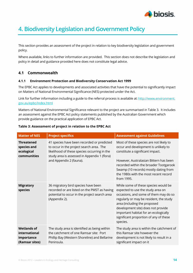
4. Biodiversity Legislation and Government Policy
This section provides an assessment of the project in relation to key biodiversity legislation and government
policy.
Where available, links to further information are provided. This section does not describe the legislation and
policy in detail and guidance provided here does not constitute legal advice.
4.1 Commonwealth
4.1.1 Environment Protection and Biodiversity Conservation Act 1999
The EPBC Act applies to developments and associated activities that have the potential to significantly impact
on Matters of National Environmental Significance (NES) protected under the Act.
Link for further information including a guide to the referral process is available at: http://www.environment.
gov.au/epbc/index.html
Matters of National Environmental Significance relevant to the project are summarised in Table 3. It includes
an assessment against the EPBC Act policy statements published by the Australian Government which
provide guidance on the practical application of EPBC Act.
Table 3: Assessment of project in relation to the EPBC Act
Matter of NES Project specifics Assessment against Guidelines
Threatened
species and
ecological
communities
41 species have been recorded or predicted
to occur in the project search area. The
likelihood of these species occurring in the
study area is assessed in Appendix 1 (flora)
and Appendix 2 (fauna).
Most of these species are not likely to
occur and development is unlikely to
constitute a significant impact.
However, Australasian Bittern has been
recorded within the broader Tootgarook
Swamp (10 records) mostly dating from
the 1980s with the most recent record
from 1995.
Migratory
species
36 migratory bird species have been
recorded or are listed on the PMST as having
potential to occur in the project search area
(Appendix 2).
While some of these species would be
expected to use the study area on
occasions, and some of them may do so
regularly or may be resident, the study
area (including the proposed
development site) does not provide
important habitat for an ecologically
significant proportion of any of these
species.
Wetlands of
international
importance
(Ramsar sites)
The study area is identified as being within
the catchment of one Ramsar site: Port
Phillip Bay (Western Shoreline) and Bellarine
Peninsula.
The study area is within the catchment of
this Ramsar site however the
development is not likely to result in a
significant impact on it

© Biosis 2012 – Leaders in Ecology and Heritage Consulting 15
On the basis of potential for significant impacts on NES, the EPBC Act is likely to be triggered and referral of
the proposed action to the Australian Government Minister for the Environment is recommended.
4.2 State
4.2.1 Flora and Fauna Guarantee Act 1988 (FFG Act)
The FFG Act is Victorian legislation aimed at the conservation of threatened species and communities and for
the management of potentially threatening processes. Under the FFG Act a permit is required from DSE to
'take' protected flora species from public land. A permit is generally not required for removal of protected
flora from private land. Authorisation under the FFG Act is required to collect, kill, injure or disturb listed fish.
Link for further information: http://www.depi.vic.gov.au/environment-and-wildlife/threatened-species-and-
communities/flora-and-fauna-guarantee-act-1988
Native vegetation on site is not a listed community, and does not contain any listed threatened flora species
or habitat for them (Appendix 1). However the site does provide habitat for listed fauna species.
The land is privately owned, is not declared ‘critical habitat’ for the purposes of the FFG Act, and the flora
species are not being taken for the purpose of commercial sale. Therefore a protected flora permit is not
required. However the presence of habitat for threatened fauna will be considered by the Responsible
Authority in determining its response to an application for vegetation clearance under Clause 52.17 (see
below).
4.2.2 Catchment and Land Protection Act 1994 (CaLP Act)
The CaLP Act identifies and classifies certain species as noxious weeds or pest animals, and provides a system
of controls on noxious species.
Eight declared noxious weeds were identified in the study area and are listed in Appendix 1.
The proponent/land owner must take all reasonable steps to eradicate regionally prohibited weeds, prevent
the growth and spread of regionally controlled weeds, and prevent the spread of and as far as possible
eradicate established pest animals. The State is responsible for eradicating State prohibited weeds from all
land in Victoria.
Link for further information: http://www.depi.vic.gov.au/agriculture-and-food/pests-diseases-and-weeds
4.2.3 Planning and Environment Act 1987 (incl. Planning Schemes)
The Planning and Environment Act 1987 controls the planning and development of land in Victoria, and
provides for the development of planning schemes for all municipalities.
Reforms to the native vegetation permitted clearing regulations were gazetted on 20 December 2013 through
planning scheme amendment VC105. The reforms made changes to the Victoria Planning Provisions
including the State Planning Policy Framework (SPPF), Clause 52.16 and 52.17 of all planning schemes within
Victoria.
Of particular relevance to the development proposed are controls relating to the removal, destruction or
lopping of native vegetation contained within the Mornington Peninsula Planning Scheme (the Scheme),
including permit requirements. The Scheme (Clause 72) defines ‘native vegetation’ as 'Plants that are
indigenous to Victoria, including trees, shrubs, herbs and grasses'. It is an objective of Clause 12.01-2 of the
SPPF (Native Vegetation Management) that permitted clearing of native vegetation results in no net loss in the
contribution made by native vegetation to Victoria’s biodiversity. For more information on these reforms
© Biosis 2012 – Leaders in Ecology and Heritage Consulting 16
refer to www.depi.vic.gov.au/nativevegetation. An assessment of the proposed development in relation to
the Guidelines is provided in Section 5.
Clause 52.17 (Native Vegetation) requires a planning permit to remove, destroy or lop native vegetation
including some dead native vegetation. None of the exemptions identified in the relevant table of
exemptions (Clause 52.17-6) apply to this site. Clause 52.17 does not apply if a Native Vegetation Precinct
Plan corresponding to the land is incorporated in the Planning Scheme. This does not appear to be the case
for this property.
Clause 65.02 requires consideration of native vegetation retention in a subdivision application and siting of
open space areas.
Under Clause 66.02 a permit application to remove, destroy or lop native vegetation is required to be referred
to DEPI as a recommending referral authority if the area of native vegetation to be removed is greater than 5
hectares, or the class of application is in the high risk-based pathway, or where a property vegetation precinct
plan applies to the site, or the native vegetation is on Crown land occupied or managed by the Responsible
Authority.
The need for a permit to remove native vegetation may also be triggered by the Environmental Significance
Overlay within the Mornington Peninsula Planning Scheme. The location of overlays in relation to the study
area can be determined via the following link: http://planningschemes.dpcd.vic.gov.au/index.html. The
provisions of the following overlays apply to the study area:
Environmental Significance Overlay 19 (ESO19) covers the entire study area. The schedule states the
environmental significance of areas covered by ESO 19 as follows:
"The areas of alluvial plain and reclaimed swamp on the Mornington Peninsula, which support characteristic
vegetation communities, are an integral element of the environmental systems that support biodiversity. These areas
may have limited drainage capacity."
While no additional permit requirements apply the objectives of the overlay are to:
• protect the stability and environmental values of alluvial plains and reclaimed swamp with
characteristic vegetation communities.
• avoid contamination of ground water and the degradation of significant habitat areas.
• limit development within environmentally sensitive areas.
Relevant decision guidelines include:
• The environmental objectives of this schedule.
• Whether there is any reasonable alternative site for the proposed buildings and works outside of the
overlay area, or any alternative land management or construction practices, that would better meet
the objectives of this schedule.
• Whether substantial change or detriment will be caused to the stability, vegetation, water quality or
habitat values of the area.
• The protection of alluvial plains and reclaimed swamps for their environmental and scientific value.
• The potential for flooding to occur, and whether the proposed development will impose any
additional flooding or drainage risk or constraints over land in the vicinity.
While the proposed subdivision is consistent with the underlying zone (RZ1) some of the native vegetation
within the property would need to be cleared to produce the subdivision. The proposed subdivision is
restricted to the area zoned residential and would limit clearing to 2.629 ha of native vegetation or about 11%

© Biosis 2012 – Leaders in Ecology and Heritage Consulting 17
of the native vegetation within the property. The balance of the native vegetation is proposed to be protected
for conservation and vested with council to be managed as an offset area. This would protect a high
proportion of that vegetation in line with the objectives of the ESO. This could be assessed as a substantial
positive outcome for the protection of the native vegetation present and result in significant protection for
this wetland area.
Victoria's Biodiversity Assessment Guidelines
The Guidelines are incorporated into the Victoria Planning Provisions and all planning schemes in Victoria
(DEPI 2013). These Guidelines replace the Victoria's Native Vegetation Management – A Framework for Action
(NRE 2002).
The purpose of the Guidelines is to guide how impacts on biodiversity should be considered when assessing a
permit application to remove, destroy or lop native vegetation. The objective for permitted clearing of native
vegetation in Victoria is 'No net loss in the contribution made by native vegetation to Victoria's biodiversity'.
A detailed assessment of the implications for the project under the Guidelines is provided in Section 5 of this
report. Under the Guidelines, there are three risk-based pathways for assessing an application for a permit to
remove native vegetation:
• low risk
• moderate risk
• high risk
A detailed determination of the risk-based pathway for the planning application relevant to the proposed
development is provided in Section 5.3.2. In summary, the planning application for removal of native
vegetation must meet the requirements of, and be assessed in, the moderate risk based pathway. A
biodiversity assessment report identifying the approximate area of native vegetation to be lost and the
relevant details associated with the assessment pathway is provided in Appendix 3.
4.2.4 Wildlife Act 1975 and associated Regulations
The Wildlife Act 1975 (Wildlife Act) is the primary piece of legislation in Victoria providing for protection and
management of wildlife. The Wildlife Act does not apply to fish, as defined under the Fisheries Act 1995.
The Wildlife Regulations 2002 prescribe penalties for persons who wilfully damage, disturb or destroy any
wildlife habitat without appropriate authorisation. DEPI advises that a planning permit (under the planning
scheme) constitutes appropriate authorisation and therefore the habitat protection provisions under the
Wildlife Regulations 2002 are not applicable once a planning permit has been granted for this project.
4.2.5 Environmental Effects Act
The Environment Effects Act 1978 establishes a process to assess the environmental impacts of a project. If
applicable, the Act requires that an Environment Effects Statement (EES) be prepared by the proponent. The
EES is submitted to the Minister for Planning to enable assessment of the potential environmental effects of
the proposed development.
The general objective of the assessment process is to provide for the transparent, integrated and timely
assessment of the environmental effects of projects capable of having a significant effect on the environment (DSE
2006).
The ‘Ministerial Guidelines for Assessment of Environmental Effects under the Environment Effects Act 1978’
(DSE 2006a) provide a range of criteria that can be used to determine whether an EES may be required for a
project. These criteria relate to individual potential environmental effects and a combination of (two or more)

© Biosis 2012 – Leaders in Ecology and Heritage Consulting 18
potential environmental effects. As the proposed loss of native vegetation is less than 10 ha it is considered
unlikely that the proposed development would be subject to an EES.
However, the guidelines are not binding, and the decision as to whether an EES is required is ultimately at the
discretion of the Minister for Planning.
4.2.6 Water Act 1989
The primary purpose of the Water Act 1989 is to provide a framework for the allocation and management of
surface water and groundwater throughout Victoria. It provides a principal mechanism for maintenance of
ecosystem functions including those of aquatic ecosystems. Under By-Laws created by the relevant Authority
under the Act, the authorities regulate the works within and in the vicinity of waterways. In Melbourne
Water's management area this applies to all waterways with a catchment area of 60 ha or more. These
waterways are deemed to be Melbourne Water assets, while all smaller watercourses are deemed the
responsibility of the local government.
The proposed development will involve construction or maintenance activities that may affect waterways
through increased or decreased surface run off. Development within the study area will require a permit
from Melbourne Water. Guidelines and application forms can be obtained from Melbourne Water's Asset
Service team.
For developments within Melbourne Water's management area that entail the provision of new drainage
infrastructure, approval for works on waterways is covered under the Agreement process set out in the Land
Development Manual (http://ldm.melbournewater.com.au/content/introduction/introduction.asp.
4.2.7 Environment Protection Act 1970: State Environmental Protection Policy (Waters of Victoria)
2003
The Environment Protection Act underpins the State Environmental Protection Policy (SEPP) – Waters of
Victoria which provides a legal framework for the protection and rehabilitation of Victoria’s surface water
environments.
The project may directly and/or indirectly impact upon a river and its aquatic ecosystems. The SEPP requires
that aquatic ecosystem values be protected. Environmental quality objectives and indicators are defined to
protect beneficial uses (i.e. the uses and values of the water environment) and an attainment program
provides guidance on protection of the beneficial uses.
Impacts to surface water quality must not result in changes that exceed background levels and/or the water
quality objectives specified for the Cleared Hills and Coastal Plains segment to protect surface water uses and
values. The proponent needs to ensure that direct and indirect (e.g. runoff) impacts to surface water quality
do not exceed the background levels and/or water quality objectives.
Link to further information: http://www.epa.vic.gov.au/water/epa/wov.asp.
4.2.8 Revegetation Plan Enforcement Order
A VCAT Enforcement Order was issued in 2011for illegal vegetation clearance at the site (VCAT Reference No.
P2811/2010). The reported clearing included broad area slashing of the vegetation present resulting in the
cutting of large areas dominated by Common Reed and subsequent pasture improvement, including the
sowing of rye grass Lolium spp. and application of fertilizer (Mornington Peninsula Shire Council 2012).
Council also indicated that indigenous shrubs had been removed from the Chinamans Creek environs.
The Enforcement Order requires the preparation of a Re-vegetation Plan. The VCAT Order requires a specific
re-vegetation area to be nominated within the site although the order does not specify that the entire site
© Biosis 2012 – Leaders in Ecology and Heritage Consulting 19
must be revegetated. However, Council has advised that while the VCAT Order allows for a designated Re-
vegetation area, a weed management schedule must be prepared for the entire site.
A draft revegetation plan was prepared by Water Technology (2011) but was never finalised after comments
were made by Mornington Peninsula Shire Council (2012).
The illegal clearing and pasture improvements were only possible when much of the site was dry. However
while the slashing, herbicide application and pasture improvements clearly had an impact on the sites
vegetation this impact appears to have been largely temporary.
Observations in association with the Biosis assessments Indicate the site was largely inundated between
September 2013 and January 2014. The extent of inundation in September 2013 suggests that the site had
already been inundated for a prolonged period. Given the extent and condition of native vegetation
observed, it is considered unlikely that clearing activities have had a significant impact on the species
composition of these wetlands.
Wetland vegetation is relatively resilient to superficial disturbance such as slashing and shallow soil
disturbance. The recent inundation has allowed the dominant species normally associated with all the
wetland vegetation types present to regenerate and develop to their full stature. It is most likely that only any
clearing of larger shrubs such as Swamp Paperbark Melaleuca ericifolia and Woolly Tea-tree Leptospermum
lanigerum or large perennial tussocks such as Coast Saw-sedge Gahnia trifida would have resulted in a lasting
loss of native species and vegetation structure. The extent of any such losses, if any is not well documented.
The vegetation mapping provided by Water Technology (2011) compares the vegetation observed with
mapping prepared by Practical Ecology (2006). Comparison with the current mapping suggests there has
been some reduction in the extent of the area Biosis has identified as Habitat Zone 5.
Practical Ecology (2006) also identified an area of Plains Grassland (their patch 3, coloured red). Reports
prepared by Practical Ecology (2006) and Water Technology (2011) were not provided to Biosis before our
field inspection and therefore the impact of the reported clearing on this area of Plains Grassland was not
determined. At the time of the Biosis assessment this area had been slashed and the dominant species
identified for this community (Common Tussock-grass Poa labillardierei) was not identified as a patch of native
grassland. As the patch of grassland was recorded both pre and post clearing, the clearing presumably did
not remove this area of native vegetation. It may once again regenerate as this dry-land area regenerates
from slashing. However the Water Technology assessment is problematic as it allocated the understorey
component of the habitat score as zero, which suggests a patch was not present. The available photos of this
vegetation, the lists of species recorded and Practical Ecology (2006) suggests this vegetation was of low
species richness and in poor condition.
With the filling of the wetland prior to this assessment, the great majority (80% or 23.98 ha of the 29.84 ha
property) of the site is covered by vigorous native vegetation, generally with a low cover of exotic species.
This suggests that any clearing conducted on the site did not involve any significant soil disturbance which
would otherwise be required to result in the permanent loss of at least some of the native species present.
The wetland vegetation present appears to occupy all areas typically subject to periodic inundation. As a
result no direct revegetation works are considered necessary as the site has regenerated naturally. Biosis
would therefore recommend that no actions are required to allow the vegetation to return to its pre-
disturbance condition other than weed control works targeting invasive exotic species. Any weed control
works within the wetland vegetation would only need to be limited in extent as these wetland communities
support quite low weed levels when inundated. Flooding is therefore an efficient weed control mechanism.
When dry these wetland communities are likely to support a high cover of exotic primary colonisers such as
pasture grasses, thistles and other wind dispersed exotics such as Aster-weed Aster subulatus and Ox-tongue
Helminthotheca echioides. The control of such species is unlikely to influence the species composition of these

© Biosis 2012 – Leaders in Ecology and Heritage Consulting 20
wetlands when they are inundated. However, the control of invasive exotic wetland species such as Jointed
Rush Juncus articulatus and Spiny Rush Juncus acutus, which are currently relative rare on site would be
ecologically beneficial as these species have the potential to dominated parts of the site and otherwise
exclude indigenous wetland species.
Other noxious species present within the site, such as Blackberry Rubus fruticosus spp. agg., African Box-thorn
Lycium ferocissimum, Fennel Foeniculum vulgare and Paterson's Curse Echium plantagineum, are terrestrial
species and typically restricted to elevated areas which are dominated by non-native vegetation. A
reasonable effort to control the spread of these species is already a requirement of the CaLP Act.
Any weed control works would be conducted in a rigorous and systematic manner if the site is managed as
an offset area.

© Biosis 2012 – Leaders in Ecology and Heritage Consulting 21
5. Victoria's Biodiversity Assessment Guidelines
The Guidelines describe three strategies for ensuring the objective for permitted clearing of native vegetation
is achieved at the permit level. These are:
• avoiding the removal of native vegetation that makes a significant contribution to Victoria's
biodiversity
• minimising impacts to Victoria's biodiversity from the removal of native vegetation
• where native vegetation is permitted to be removed, ensuring it is offset in a manner that makes a
contribution to Victoria's biodiversity that is equivalent to the contribution made by the native
vegetation to be removed.
DEPI has provided biodiversity information tools to assist with determining the contribution that the native
vegetation within the study area makes to Victoria's biodiversity.
The biodiversity information tools have two components:
• site based-information which is observable at a particular site
• landscape scale information which requires consideration of information beyond the site.
The following section assesses the contribution that the native vegetation within the study area makes to
Victoria's biodiversity.
Note: a glossary of terms used in relation to the Guidelines and the DEPI output reports is provided in
Appendix 3. In addition, any offset prescription identified in association with a permit that approves the
clearing of native vegetation must be secured prior to the start of that development.
5.1 Site based information
The extent of native vegetation patches were mapped within the study area (Figure 2) and the condition was
assessed in relation to standard methods (DSE 2004). The condition of native vegetation was assessed using
the DSE Vegetation Quality Assessment Sheet (DSE 2004) and pre-determined EVC benchmarks:
http://www.dse.vic.gov.au/conservation-and-environment/ecological-vegetation-class-evc-benchmarks-by-
bioregion. The condition score of the patch is multiplied by the extent of the patch to give a value in habitat
hectares.
For practicality, a standard condition score and extent is applied to each scattered tree based on the habitat
hectares method. Scattered trees are defined as mature indigenous canopy trees that are in a location with
little or no native understorey. A canopy tree is a mature tree that is greater than three metres in height and
is normally found in the upper layer of a vegetation type. Ecological Vegetation Class (EVC) descriptions
provide a list of the typical canopy species.
As no scattered trees are present within the study area this component of the assessment process is not
considered further.
For the purposes of this assessment the limit of the resolution for the habitat hectare assessment process is
taken to be 0.01 habitat hectares (Hha). That is, if native vegetation is present with sufficient cover but its
condition and extent would not result in the identification of at least 0.01 habitat hectares then that
vegetation will not be mapped or assessed as a separate habitat zone. Areas of uniform quality for each EVC
within the patches are termed ‘habitat zones’ and assessed separately.

© Biosis 2012 – Leaders in Ecology and Heritage Consulting 22
5.1.1 Habitat Hectares
A total of four habitat zones are identified (Figure 2). The results of the condition assessment are provided in
Table 4, with the number of habitat hectares in each habitat zone.
Table 4: Habitat hectares of native vegetation within the study area
Habitat Zone 1 2 3 4 5 TOTAL
Bioregion Gippsland Plain
EVC Name Tall
Marsh
Aquatic
Herbland
Brackish
Wetland
Brackish
Wetland
Brackish
Wetland
EVC Number 821 653 656 656 656
EVC Bioregional Conservation Status Endangered
Max Score Score Score Score Score Score
Co
nd
itio
n S
co
re
Large Old Trees 10 NA NA NA NA NA
Canopy Cover 5 NA NA NA NA NA
Lack of Weeds 15 13 15 11 7 4
Understorey 25 20 20 15 15 15
Recruitment 10 10 10 10 10 10
Organic Matter 5 3 5 3 3 3
Logs 5 NA NA NA NA NA
Total Site Score 46 50 39 35 32
EVC standardiser (x 75/55) 1.36 1.36 1.36 1.36 1.36
Adjusted Condition Score 62.7 68.2 53.2 47.7 43.6
Landscape Score 25 16 16 16 16 16
Habitat points = #/100 100 78.7 84.2 69.2 63.7 59.6
HABITAT SCORE 1 0.79 0.84 0.69 0.64 0.60
Habitat Zone extent (ha) 18.14 2.52 0.141 1.249 1.927 23.98
Habitat Hectares (Hha) 14.33 2.17 0.10 0.80 1.16 18.56
Summary of habitat hectares within study area
In summary, the study area supports 23.98 land hectares of native vegetation comprising 18.56 habitat
hectares.

© Biosis 2012 – Leaders in Ecology and Heritage Consulting 23
5.2 Landscape scale information
5.2.2 Strategic biodiversity score
The strategic biodiversity score is derived using a spatial prioritization tool that ranks locations in Victoria for
their conservation priority on the basis of rarity and level of depletion of the Ecological Vegetation Class and
species habitats, and the condition and connectivity of vegetation. Strategic biodiversity scores for the native
vegetation within the study area are derived from the NVIM and are provided in Table 5 and otherwise
detailed in Appendix 3.
Table 5: Strategic biodiversity scores of habitat zones proposed for clearing within the study area
DEPI Habitat Zone Strategic Biodiversity Score
1 (HZ 5 in this report) 0.722
2 (Part of HZ 1 in this
report)
0.832
3 (Part of HZ 1 in this
report)
0.729
4 (Part of HZ 1 in this
report)
0.798
Minimum requirement for offset: 0.589
5.2.3 Habitat importance score
Habitat importance score is a measure of the importance of a location in the landscape as habitat for a
particular rare or threatened species in relation to other suitable habitat for that species (DEPI 2013). Only
species listed as threatened or rare under the DEPI Advisory lists (DSE 2005, 2007) are considered. The term
'threatened' is used to describe species that are classified as vulnerable, endangered or critically endangered.
Species classified as data deficient or near threatened are not considered to be 'threatened' (DSE 2013). The
term 'rare' has application for flora species only (DSE 2005).
Only native vegetation that is habitat for rare or threatened species is assigned a habitat importance score.
The habitat is divided into two categories depending on area of occupancy: dispersed habitat, or highly
localised habitat. The habitat importance score is calculated differently for each of these groups.
The score is generated by DEPI's Habitat importance mapping of the study area. No habitat importance
scores were generated by DEPI for the proposed clearing as only a general offset is required. However the
proposed offset area does provided habitat for rare or threatened species and the habitat importance scores
for this area are presented in Table 6.
5.3 Proposed removal of native vegetation
The proposed removal of native vegetation is assessed in accordance with the concept design provided. It is
proposed to remove 1.720 habitat hectares as shown in Table 7.
5.3.2 Determining the risk-based pathway
To determine the risk based pathway for the permit application, two factors are considered: location risk
and extent risk.

© Biosis 2012 – Leaders in Ecology and Heritage Consulting 24
Table 6: Habitat importance scores of Biodiversity Class Areas within the study area*
Biodiversity
Class Area
Dispersed
habitat
Overall habitat
importance
score
Strategic
Biodiversity
score
1 All Species 0.666-0.778 0.748
2 All Species 0.668-0.796 0.742
3 All Species 0.673-0.823 0.780
4 All Species 0.700-0.830 0.776
5 All Species 0.719-0.850 0.892
6 All Species 0.684-08.00 0.855
7 All Species 0.677-0.814 0.783
8 All Species 0.734-0.840 0.831
9 All Species 0.735-0.838 0.783
* outputs provided by DEPI native vegetation support team
Table 7: Summary of habitat hectares to be removed
Source Ecological Vegetation Class Habitat hectares (Hha) to
be removed
Habitat Zone 1 Tall Marsh 0.594
Habitat Zone 2 Aquatic Herbland 0.00
Habitat Zone 3 Brackish Wetland 0.00
Habitat Zone 4 Brackish Wetland 0.00
Habitat Zone 5 Brackish Wetland 1.125
TOTAL 1.720
Location risk has been pre-determined by DEPI for all locations in Victoria. The location of a particular site is
determined using the Native vegetation location risk map available in the Native Vegetation Information
Management (NVIM) system (http://nvim.depi.vic.gov.au).
Extent risk is based on the extent of native vegetation proposed to be removed and is determined with
reference to:
• the area of any remnant patches of native vegetation proposed to be removed
• the number of any scattered trees proposed to be removed.

© Biosis 2012 – Leaders in Ecology and Heritage Consulting 25
Subject to final design, the proposed development will require the removal of approximately 2.628 ha of
native vegetation, with the associated retention of 21.351 ha of native vegetation. The study area is in
Location A (Appendix 3), and because of the extent of vegetation proposed for removal, the application for
removal of this native vegetation is likely to be assessed using the moderate risk-based pathway. These
requirements are provided in Appendix 3.
The proposed removal of native vegetation is assessed in detail in Section 0 and summarised below.
5.4 Offsetting the loss of native vegetation
In order to ensure a gain to Victoria’s biodiversity that is equivalent to the loss resulting from permitted
clearing of native vegetation, compensatory offsets are required. Losses and gains are measured in
biodiversity equivalence scores or units.
Under the Guidelines any losses of vegetation within sites that are assessed under the low risk-based
pathway can be offset by the provision of a 'general offset'. The specific-general offset test will determine if a
general offset, specific offset or combination of both is required for moderate and high risk-based pathway
applications.
Note that at this point in time offset prescriptions required under the moderate and high risk assessment
pathways can only be provided by DEPI. The proposed development footprint submitted to DEPI for
assessment is outlined in Figure 3.
5.4.2 Specific-general offset test
As the risk-based pathway is moderate, and the vegetation to be removed provides habitat for rare or
threatened species, the specific-general offset test must be applied. Where a site is habitat for a particular
rare or threatened species, the specific-general offset test measures the proportion of a species habitat that
will be lost if the removal of native vegetation is permitted.
The specific-general offset test is undertaken for each relevant species. First the specific biodiversity
equivalence score for each rare or threatened species that the native vegetation is habitat for is determined.
The specific biodiversity equivalence score for a particular species is then divided by the sum of the specific
biodiversity equivalence scores across all remaining habitat for that species. This gives the proportion of the
remaining habitat for the species that is to be to removed, weighted by its importance for that species.
When the native vegetation to be removed is a proportion of habitat for a rare or threatened species that is
greater than the specific offset threshold, a specific offset is required for that species. A specific offset is
required for a rare or threatened species when the proposed clearing exceeds the DEPI nominated impact
threshold (nominally 0.005% of habitat).
For the proposed clearing at Elizabeth Avenue the specific-general offset test determined that the proposed
removal of native vegetation will not have a proportional impact on any rare or threatened species habitats
above the specific offset threshold (0.005%). No specific offsets are identified and therefore no discussion
relating to such offsets is provided by this report.
5.4.3 General offsets
The size of the general offset is determined by calculating the general biodiversity equivalence score of the
vegetation to be removed.
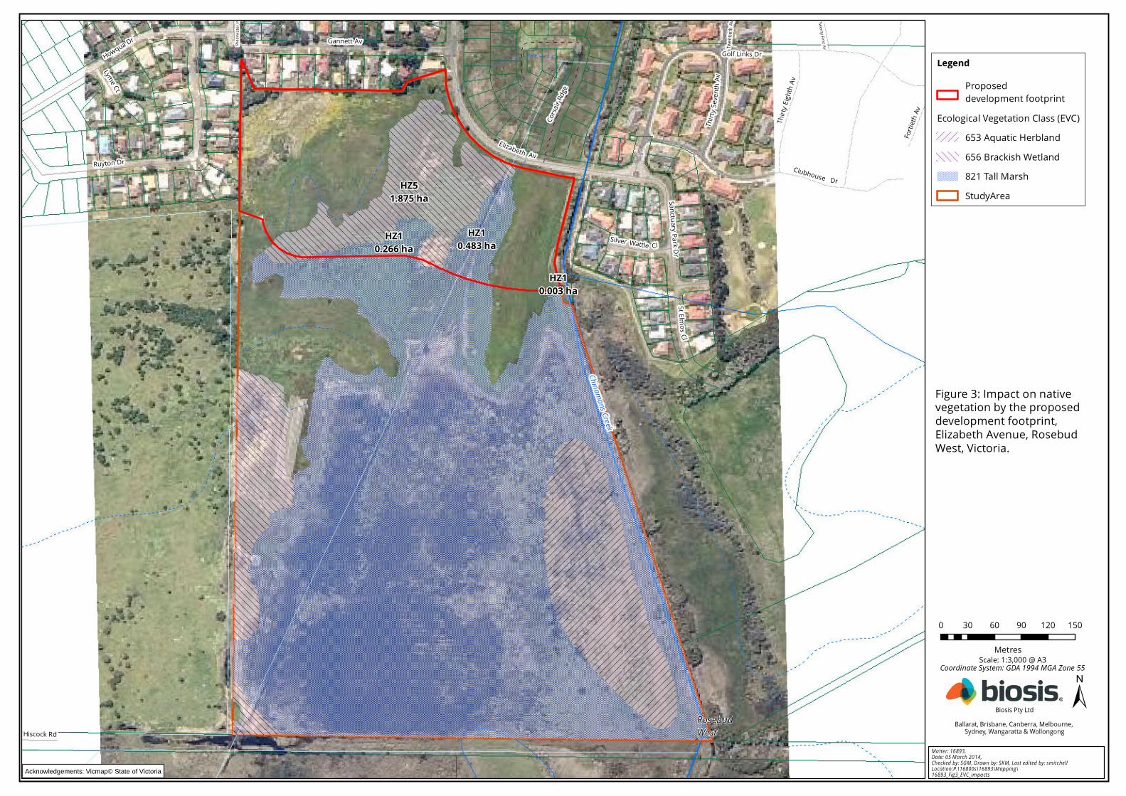
RosebudWest
Shea
rwate
r Pl
Twen
tieth
Av Twenty First Av
Golf Links Dr
Hiscock Rd
Sanctuary Park Dr
Howqua Dr
Lyme Ct
Fortie
th Av
Clubhouse Dr
Silver Wattle Cl
StE lm os Cl
Thirty
Seve
nthAv
Elizabeth Av
Thirty
Eigh
th Av
Corsa
ir Rdg
e
Gannett Av
Ruyton Dr
Chinamans Creek
HZ51.875 ha
HZ10.003 ha
HZ10.266 ha
HZ10.483 ha
0 30 60 90 120 150
Metres
±Matter: 16893, Date: 05 March 2014, Checked by: SGM, Drawn by: SKM, Last edited by: smitchellLocation:P:\16800s\16893\Mapping\16893_Fig3_EVC_impacts
Biosis Pty LtdBallarat, Brisbane, Canberra, Melbourne,
Sydney, Wangaratta & Wollongong
Scale: 1:3,000 @ A3
Figure 3: Impact on nativevegetation by the proposeddevelopment footprint,Elizabeth Avenue, RosebudWest, Victoria.
Coordinate System: GDA 1994 MGA Zone 55
Acknowledgements: Vicmap© State of Victoria
LegendProposed development footprint
Ecological Vegetation Class (EVC)653 Aquatic Herbland656 Brackish Wetland821 Tall MarshStudyArea

© Biosis 2012 – Leaders in Ecology and Heritage Consulting 27
The general biodiversity equivalence score is calculated as the product of two characteristics of the native
vegetation to be cleared:
• site based condition and extent measured in habitat hectares
• the 'strategic biodiversity score' of the vegetation which provides a landscape scale assessment of the
vegetation's' importance to Victoria's biodiversity; the strategic biodiversity score is provided via the
NVIM.
These characteristics are combined to obtain an overall measure of the contribution to biodiversity that is lost
from removing native vegetation. The same units are used to quantity vegetation offset requirements where
the biodiversity equivalence score provides a measure of the contribution to biodiversity that is gained from
securing and managing an offset.
The NVIM was used to calculate a general biodiversity equivalence score ranging between 0.002 and 0.812 for
the native vegetation proposed to be removed. The NVIM generated report is included in Appendix 3.
General offset requirements are calculated as the product of the general biodiversity equivalence score and
an 'offset risk factor'. The offset risk factor adjusts the offset to adequately accommodate the risk that an
offset may fail to make the required contribution to Victoria's biodiversity. For low risk-based pathway
assessments the offset risk factor is set at 1.5.
Therefore the general offset requirement for the proposed removal of native vegetation is 1.909 biodiversity
equivalence units.
The offset must have the required attributes:
• a strategic biodiversity score of at least 80 per cent of the strategic biodiversity score of the clearing
site
• be located in the same Catchment Management Authority (CMA) boundary or municipal district as
the native vegetation to be removed.
• Summary of general offset requirements
• Should a permit be granted to remove the native vegetation within the proposed development
footprint (Figure 3), the offset requirement is 1.909 general biodiversity equivalence units. The
strategic biodiversity score of the offset should be at least 0.589. The offset must be located in the
Port Phillip and Westernport CMA boundary or the Mornington Peninsula municipal district (if that
district extends outside of the CMA).
5.4.4 Suitability for On-site offsets
The ability for the 21.356 ha of retained native vegetation to provide some or all of the offset prescription is
governed by a set of site eligibility criteria (DEPI 2013). For all first party offsets (i.e. property within the same
ownership as the development resulting in the offset prescription) the Responsible Authority will check and
confirm a site's eligibility.
An area of native vegetation is eligible to be an offset if there are no current or future land use(s) identified
that are incompatible with managing native vegetation for conservation. This includes requirements for
bushfire suppression, infrastructure easements, road reserves, extractive industries works approvals etc.
(DEPI 2013). Land must also not have already been used to offset the clearance of native vegetation or
species habitat required by Victorian regulations. Any other significant threats beyond the landowners
control may also exclude a site from being eligible including dieback, erosion, salinity, significant infestations
of pest animals etc. (DEPI 2013: Section 3). Any offset area must be able to be secured for conservation by a
legally enforceable agreement.
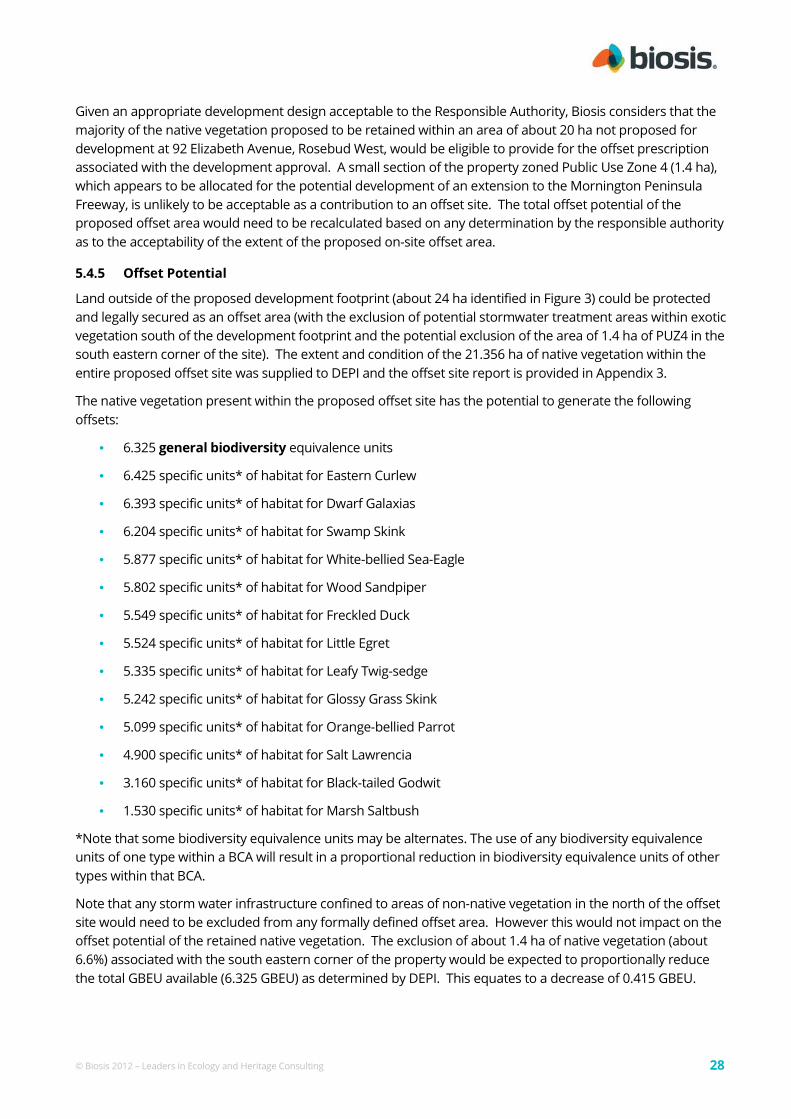
© Biosis 2012 – Leaders in Ecology and Heritage Consulting 28
Given an appropriate development design acceptable to the Responsible Authority, Biosis considers that the
majority of the native vegetation proposed to be retained within an area of about 20 ha not proposed for
development at 92 Elizabeth Avenue, Rosebud West, would be eligible to provide for the offset prescription
associated with the development approval. A small section of the property zoned Public Use Zone 4 (1.4 ha),
which appears to be allocated for the potential development of an extension to the Mornington Peninsula
Freeway, is unlikely to be acceptable as a contribution to an offset site. The total offset potential of the
proposed offset area would need to be recalculated based on any determination by the responsible authority
as to the acceptability of the extent of the proposed on-site offset area.
5.4.5 Offset Potential
Land outside of the proposed development footprint (about 24 ha identified in Figure 3) could be protected
and legally secured as an offset area (with the exclusion of potential stormwater treatment areas within exotic
vegetation south of the development footprint and the potential exclusion of the area of 1.4 ha of PUZ4 in the
south eastern corner of the site). The extent and condition of the 21.356 ha of native vegetation within the
entire proposed offset site was supplied to DEPI and the offset site report is provided in Appendix 3.
The native vegetation present within the proposed offset site has the potential to generate the following
offsets:
• 6.325 general biodiversity equivalence units
• 6.425 specific units* of habitat for Eastern Curlew
• 6.393 specific units* of habitat for Dwarf Galaxias
• 6.204 specific units* of habitat for Swamp Skink
• 5.877 specific units* of habitat for White-bellied Sea-Eagle
• 5.802 specific units* of habitat for Wood Sandpiper
• 5.549 specific units* of habitat for Freckled Duck
• 5.524 specific units* of habitat for Little Egret
• 5.335 specific units* of habitat for Leafy Twig-sedge
• 5.242 specific units* of habitat for Glossy Grass Skink
• 5.099 specific units* of habitat for Orange-bellied Parrot
• 4.900 specific units* of habitat for Salt Lawrencia
• 3.160 specific units* of habitat for Black-tailed Godwit
• 1.530 specific units* of habitat for Marsh Saltbush
*Note that some biodiversity equivalence units may be alternates. The use of any biodiversity equivalence
units of one type within a BCA will result in a proportional reduction in biodiversity equivalence units of other
types within that BCA.
Note that any storm water infrastructure confined to areas of non-native vegetation in the north of the offset
site would need to be excluded from any formally defined offset area. However this would not impact on the
offset potential of the retained native vegetation. The exclusion of about 1.4 ha of native vegetation (about
6.6%) associated with the south eastern corner of the property would be expected to proportionally reduce
the total GBEU available (6.325 GBEU) as determined by DEPI. This equates to a decrease of 0.415 GBEU.

© Biosis 2012 – Leaders in Ecology and Heritage Consulting 29
6. Key Ecological Values and Recommendations
This section identifies the key ecological features of the study area, provides an outline of potential
implications of proposed development on those values and includes recommendations to assist Beveridge
Williams, acting on behalf of Watermark Village Pty Ltd, to finalise a development design to minimise impacts
on biodiversity.
The primary measure to reduce impacts to biodiversity values within the study area is to minimise removal of
native vegetation and terrestrial and aquatic habitats. It is critical that this be considered during the design
phase of the project, when key decisions are made about the location of major roads and services, parks and
housing areas. The results of this assessment should therefore be incorporated into the project design, by
adding the flora and fauna mapping information into the planning maps and investigating options to retain as
much of the mapped vegetation/habitats as possible. Priority should be given to highest value areas and
retaining larger areas in preference to numerous smaller ones.
The design phase is also the time during which future requirements for infrastructure and services must be
forecast and allowance made outside any nominated reserves for all construction works, such as road
batters, footpaths, drainage and services (including optic fibre). All areas of vegetation/habitat nominated in
the design plan as 'retained' are to be treated as no-go zones and are not to be encroached upon as
development progresses.
A summary of potential implications of development within the study area and recommendations to
minimise impacts during the design phase of the project is provided in Table 8.
Construction and post-construction management
Specific detail relating to preventing impacts to retained native vegetation and aquatic and terrestrial habitat
should be addressed in a site-specific Construction Environmental Management Plan. This will include issues
relating to contractors such as environmental inductions, installation of temporary fencing/signage, drainage
and sediment control.
An Ecological Management Plan should be prepared by an ecological consultant to provide detailed advice on
the ongoing protection and long-term management of retained vegetation/ habitat, creation of linkages and
other habitat features such as wetlands, if proposed.
Retained native vegetation will be subject to permanent legal protection and the implementation of an
ecological management plan consistent with the requirements of DEPI (2013 – gain scoring manual).

© Biosis 2012 – Leaders in Ecology and Heritage Consulting 30
Table 8: Summary of key ecological values, potential implications of developing the study area
and recommendations to minimise ecological impacts during the design phase
Ecological feature
(Figure 2)
Implications of development Recommendations
Native vegetation Permanent removal of up to 1.719 habitat
hectares of vegetation.
Removal of habitat for EPBC Act listed
significant species including:
Australasian Bittern
Latham's Snipe
Avoid and minimise removal of native
vegetation, in accordance with the
Biodiversity Assessment Guidelines.
Identify and implement appropriate
offsets for vegetation losses as outlined in
Section 5.4. There is an opportunity to
provide all offsets on site.
Areas of retained native vegetation in the
south of the property would require
permanent reservation and the
preparation of an offset management plan
for this vegetation to function as a first
party offset site.
Other habitat
features
Removal of known/potential habitat for
significant fauna species (as identified in
Table 2).
Loss of, or alterations to, wetland habitat
within the study area via: direct removal,
potential hydrological changes,
deterioration in water quality (including
pollution event) and sedimentation.
Avoid/minimise removal of wetland habitat
by designing to avoid or minimise impacts
on areas of native vegetation identified in
Figure 2.
Place any stormwater treatment/retention
wetlands outside areas of retained
vegetation.
Protect key values (including waterways)
by retaining features and including
appropriate buffers into design.
Design the development with a road
interface to retained vegetation rather
than rear lot boundaries to provide an
additional buffer from adjacent land uses.
Habitat
connectivity
Removal of vegetation / habitat that
forms part of a broader area of native
vegetation.
The vegetation proposed for clearing is on
the margin of a broader area of wetland
habitat. The overall habitat connectivity of
the broader wetland would therefore not
be impacted although smaller areas of
native vegetation may have reduced
longer term viability.

© Biosis 2012 – Leaders in Ecology and Heritage Consulting 31
References
Biosis 2014. Addendum to flora and fauna assessment report for 92 Elizabeth Avenue Rosebud West: Aquatic
fauna assessment. Report to Beveridge and Williams. Author: Anthony Steelcable. Biosis Pty Ltd, Melbourne.
Project no. 16893.
DEPI 2013a. Permitted clearing of native vegetation - Biodiversity assessment guidelines. Victorian Government
Department of Environment and Primary Industries, Melbourne.
DEPI 2013b. Native vegetation gain scoring manual – Version 1. Victorian Government Department of
Environment and Primary Industries, Melbourne.
DNRE 2002. Victoria's Native Vegetation Management: A Framework for Action. Victorian Government
Department of Natural Resources & Environment, East Melbourne.
DSE 2004. Native Vegetation: Sustaining a living landscape. Vegetation Quality Assessment Manual – Guidelines for
applying the habitat hectares scoring method. Version 1.3. Victorian Government Department of Sustainability &
Environment, Melbourne.
DSE 2005. Advisory List of Rare or Threatened Plants in Victoria – 2005. Victorian Government Department of
Sustainability & Environment, East Melbourne.
DSE 2006. Ministerial Guidelines for Assessment of Environmental Effects under the Environment Effects Act 1978.
Victorian Government Department of Sustainability and Environment, Melbourne.
DSE 2013. Advisory List of Threatened Vertebrate Fauna in Victoria – 2013. Victorian Government Department of
Environment & Primary Industries, Melbourne.
DSE 2007. Native Vegetation – Guide for assessment of referred planning permit applications. Victorian
Government Department of Sustainability & Environment, East Melbourne.
Practical Ecology 2006. Flora and Fauna Assessment Elizabeth Avenue Rosebud West.
Water Technology 2011. Revegetation Plan Elizabeth Avenue Rosebud West. Report for Watermark Village Pty.
Ltd. Author S. Hamilton, Water Technology, Wangaratta. Project J1143-03.


