104
October 2013 Central Lincolnshire Green Infrastructure Steering Group Biodiversity Opportunity Mapping Study for Central Lincolnshire

October 2013
Central Lincolnshire Green Infrastructure Steering Group
Biodiversity Opportunity Mapping Study for Central Lincolnshire


October 2013 Biodiversity Opportunity Mapping Study for Central Lincolnshire
11117101R_Final_Report_BW_10-13 Chris Blandford Associates
CONTENTS EXECUTIVE SUMMARY
1.0 INTRODUCTION 11.1 Background 11.2 Purpose 21.3 Objectives 21.4 Acknowledgements 3
2.0 RATIONALE AND METHODOLOGY 42.1 General 42.2 Rationale 42.3 Provisional Opportunity Mapping 52.4 Stakeholder Workshops 92.5 Refinement of Opportunity Mapping 112.6 Reporting 11
3.0 PART 1: BIODIVERSITY OPPORTUNITY MAPPING FOR CENTRAL LINCOLNSHIRE 13
3.1 Biodiversity Opportunity Area Maps 133.2 Key Habitat Opportunity Mapping 143.3 Mapping Habitat Sensitivity 173.4 Biodiversity Opportunity Area Descriptions 193.5 Schedule of Proposed Strategic Projects 43
4.0 PART 2: BIODIVERSITY OPPORTUNITY MAPPING FOR LINCOLN PRINCIPAL URBAN AREA/SUSTAINABLE URBAN EXTENSIONS/WITHAM VALLEY COUNTRY PARK 49
4.1 General 494.2 Woodland Habitat Opportunity Mapping 524.3 Wetland Habitat Opportunity Mapping 544.4 Heathland & Acid Grassland Habitat Opportunity Mapping 604.5 Calcareous Grassland Habitat Opportunity Mapping 634.6 Biodiversity Opportunity Mapping Schedule 65
5.0 CONCLUSIONS AND RECOMMENDATIONS 705.1 Biodiversity Opportunity Mapping for Central Lincolnshire 705.2 Constraints and Limitations within the mapping process 715.3 Endorsement and Communication 715.4 Biodiversity Action Plan Delivery 715.5 Green Infrastructure and Biodiversity Planning 725.6 Minerals and Waste Local Plan 775.7 Water Framework Directive Delivery 795.8 Environmental Land Management Targeting 795.9 Data Management 795.10 Recommendations for Further Work 80
October 2013 Biodiversity Opportunity Mapping Study for Central Lincolnshire
11117101R_Final_Report_BW_10-13 Chris Blandford Associates
GLOSSARY FIGURES 1.1 Central Lincolnshire Study Area 1.2 Lincoln Principal Urban Area / Lincoln’s Sustainable Urban Extensions / Witham Valley
Country Park Study Area 2.1 Study Process Central Lincolnshire Biodiversity Opportunity Maps: 3.1 Woodland Habitat Opportunity Mapping 3.2 Wetland Habitat Opportunity Mapping 3.3 Heathland & Acid Grassland Habitat Opportunity Mapping 3.4 Calcareous Grassland Habitat Opportunity Mapping 3.5 Biodiversity Opportunity Map for Central Lincolnshire 3.6 Strategic Project Areas for Central Lincolnshire Lincoln Principal Urban Area / Lincoln’s Sustainable Urban Extensions / Witham Valley Country Park Biodiversity Opportunity Maps: 4.1 Woodland Habitat Opportunity Mapping 4.2 Wetland Habitat Opportunity Mapping 4.3 Heathland & Acid Grassland Habitat Opportunity Mapping 4.4 Calcareous Grassland Habitat Opportunity Mapping 4.5 Biodiversity Opportunity Map for the Lincoln Principal Urban Area / Lincoln’s Sustainable
Urban Extensions / Witham Valley Country Park
APPENDICES A Opportunity Mapping Methodology & Data Sources B Biodiversity & Ecology Stakeholder Workshop Summary C Land Use & Planning Stakeholder Workshop Summary D Water Environment Stakeholder Workshop Summary E Witham Valley Country Park Stakeholder Workshop Summary F Background Datasets used to inform the Biodiversity Opportunity Mapping G Lincolnshire Limewoods Biodiversity Opportunity Mapping

October 2013 Biodiversity Opportunity Mapping Study for Central Lincolnshire
11117101R_Final_Report_BW_10-13 Chris Blandford Associates
EXECUTIVE SUMMARY
Background
In December 2012, Chris Blandford Associates was commissioned by the Central Lincolnshire Green
Infrastructure Steering Group to undertake a Biodiversity Opportunity Mapping (BOM) Study for Central
Lincolnshire. The BOM Study has taken forward the recommendations of the Central Lincolnshire Green
Infrastructure Study (CBA, 2011) by providing a spatial biodiversity opportunity evidence base to support
Local Plan making, in accordance with the National Planning Policy Framework objectives.
The Biodiversity Opportunity Mapping Study provides an overview of the broad spatial characteristics for
the protection, recreation and expansion of Central Lincolnshire’s ecological network. The information
contained within the BOM Study should be viewed as a starting point, rather than an end in itself, for
planning biodiversity enhancement initiatives. Specifically, the Biodiversity Opportunity Mapping Study
provides the basis for the development of Central Lincolnshire’s Ecological Network Strategy, which is a
key recommendation of the Green Infrastructure Study for Central Lincolnshire.
What is Biodiversity Opportunity Mapping?
The broad concept of a landscape-led approach to nature conservation, including the use of Biodiversity
Opportunity Mapping, has been around for many years. However, the publication of The Lawton
Review, Making Space for Nature, identified the need for ‘a coherent and resilient ecological network’
designed to cope with future challenges, particularly the effects that climate change may have on
biodiversity, the ecosystem services it underpins and upon which, ultimately, we rely on for our health
and wellbeing. The Review concludes that there are currently serious failings in England’s ecological
network and identifies the need to: “Establish a more coherent and resilient ecological network on land
that safeguards ecosystem services for the benefit of wildlife and people.”
The Biodiversity Opportunity Mapping Study takes forward the proposed actions set out in The Lawton
Review by creating GIS-based maps showing Biodiversity Opportunity Areas across Central Lincolnshire.
These represent areas in which resources should be targeted to maintain, restore, buffer, link and expand
wildlife habitats at a landscape-scale.
Study Objectives and Outputs
To provide spatial biodiversity opportunity evidence in support of Local Plan making in accordance
with the National Planning Policy Framework objectives, with specific reference to the emerging Central Lincolnshire Core Strategy and Lincolnshire Minerals and Waste Plan;

October 2013 Biodiversity Opportunity Mapping Study for Central Lincolnshire
11117101R_Final_Report_BW_10-13 Chris Blandford Associates
To create a GIS-based map showing broad proposals for biodiversity opportunity areas across Central Lincolnshire, representing areas in which resources should be targeted to maintain, restore, buffer, link and expand wildlife habitats at a landscape scale;
To produce detailed GIS-based maps and site information showing specific biodiversity opportunities for the Lincoln PUA/SUEs/WVCP, taking into account relevant strategies, plans, opportunities and constraints (existing and potential) within the next 20-50 years, and identifying areas in which resources should be targeted to maintain, restore, buffer, link and expand wildlife habitats at a landscape scale; and,
To identify strategic biodiversity enhancement projects, including cost estimates for consideration in the development of the Infrastructure Delivery Plan for Central Lincolnshire.
This process was informed through a series of workshops with local stakeholder expertise to refine the
GIS-based mapping process.
BOM Study Applications
Biodiversity opportunity mapping helps to identify and prioritise areas where investment in resources
would achieve greatest benefits; for the economy and society, not just for nature. For the first time, this
study provides Biodiversity Opportunity Mapping for the whole of Central Lincolnshire now exists to
inform a range of applications in relation to land use planning and environmental land management.
Taken together with the more detailed opportunity mapping within the Lincoln PUA/SUEs/WVCP, the
Study is considered to provide a useful tool to assist decision-making in Central Lincolnshire. In order to
maximise these benefits, the opportunity maps can be applied in in a number of ways as highlighted
below.
Planning and the Growth Agenda
The three local authorities of City of Lincoln, North Kesteven and West Lindsey have come together as
Central Lincolnshire to produce a single Local Plan under the auspices of the Joint Planning Unit. This
plan needs robust evidence on which to base decision making. This BOM Study provides such an
evidence base (as part of the wider Green Infrastructure Study) and can aid:
Planners: to inform growth plans, identify strategic linkages and direct CIL funding to best effect; and, Developers: to identify opportunities in and around developments to enhance place and therefore
prices;
The Witham Valley Country Park has been prioritised for environmental and leisure investment and
project delivery. This initiative is in the early stages of development, and is being steered through an
informal partnership of local authorities, statutory agencies and voluntary bodies. The proposed Witham
Valley Country Park is an area where housing development and industry are expected to grow; where

October 2013 Biodiversity Opportunity Mapping Study for Central Lincolnshire
11117101R_Final_Report_BW_10-13 Chris Blandford Associates
aggregates are being extracted; and where there is scope for managing the risk of flooding in and around
Lincoln. It is also an area of existing value for wildlife and has great potential to develop wildlife habitats
on a landscape scale. The BOM Study can contribute to the evolution of the Witham Valley Country Park
by identifying a range of opportunities for enhancing ecological connectivity within the context of future
growth and the provision of a range of ecosystem services.
Biodiversity Action Planning
The Lincolnshire Biodiversity Action Plan, administered by the Greater Lincolnshire Nature Partnership,
sets out the quantitative targets for increasing and enhancing the biodiversity resource of Lincolnshire.
The BOM Study can be used as the spatial framework for identifying opportunities to deliver the BAP
targets.
Minerals and Waste Site Restoration
The BOM Study can help as a tool for identifying appropriate end-use restorations for existing and future
minerals sites in Central Lincolnshire. The appropriate restoration of minerals sites can contribute
towards:
Developing the Witham Valley Country Park’s assets; Providing a significant contribution towards woodland creation and management including the
development of adaptation strategies both for floodplain management and for biodiversity; and, Large scale habitat creation schemes, including the creation of grazing marsh, fenland habitats and
heathland areas.
Water Framework Directive
The BOM Study can help as a tool for identifying biodiversity opportunities that contribute towards
delivering interventions that will improve the chemical and ecological quality of Central Lincolnshire’s
watercourses and wetlands. This is a key component for meeting water quality and water resources
obligations as required by the Water Framework Directive (WFD).
Environmental Land Management Targeting
The BOM Study can help to inform targeting of funding and advice to farmers and landowners where
activities under agri-environment schemes can be targeted to best effect within the landscape. The BOM
Study can also provide a framework to help implement reforms to the Common Agricultural Policy,
which will result in considerable changes to funding for agri-environment measures and woodland
planting.

October 2013 1 Biodiversity Opportunity Mapping Study for Central Lincolnshire
11117101R_Final_Report_BW_10-13 Chris Blandford Associates
1.0 INTRODUCTION
1.1 Background
1.1.1 Through the Central Lincolnshire Joint Planning Unit, a Local Plan is being developed jointly
across the three districts of the City of Lincoln Council, North Kesteven District Council and
West Lindsey District Council. These three district local authorities, in conjunction with
Lincolnshire County Council, are working with other key partner organisations to develop a
robust evidence base to support the development of the Plan. One component of the evidence
base has been the formulation of a Green Infrastructure (GI) Study for Central Lincolnshire,
which was completed in 20111. A recommendation of the GI Study is to develop Biodiversity
Opportunity Mapping to update and inform the delivery of the GI Strategy, including the
proposed Central Lincolnshire Ecological Network Strategy and Local GI Delivery Plans2.
1.1.2 An area to the south west of Lincoln, being promoted as the Witham Valley Country Park3 has
been prioritised for environmental and leisure investment and project delivery. This initiative is
in the early stages of development, and is being steered through an informal partnership of
local authorities, statutory agencies and voluntary bodies. The proposed Witham Valley
Country Park is an area where housing development and industry are expected to grow; where
aggregates are being extracted; and where there is scope for managing the risk of flooding in
and around Lincoln. It is also an area of existing value for wildlife and has great potential to
develop wildlife habitats on a landscape scale.
1.1.3 In order to help shape the future of the landscape and to improve the biodiversity resilience of
the area, the partners identified a need to carry out a broad assessment of biodiversity
opportunities for the whole of Central Lincolnshire, and a more detailed assessment of the
Lincoln Principal Urban Area/Sustainable Urban Extensions and the Witham Valley Country
Park (Lincoln PUA/SUEs/WVCP).
1.1.4 At both the broad Central Lincolnshire and the more detailed Lincoln PUA/SUEs/WVCP scales,
biodiversity underpins a range of ecosystem services that are pivotal in water resource and
water quality management. The Biodiversity Opportunity Mapping project identifies a range of
potential interventions that support the aims and objectives of improving resource and quality
management of surface and ground waters, as required under the Water Framework Directive4.
1 http://microsites.lincolnshire.gov.uk/centrallincolnshire/local-development-framework/eco-town-intiative/green-infrastructure-study-for-central-lincolnshire/107237.article?tab=downloads 2 See para 4.8.4 of the Green Infrastructure Study for Central Lincolnshire (CBA for the Central Lincolnshire Joint Planning Unit, 2011) 3 http://withamvalleypark.co.uk 4 http://www.environment-agency.gov.uk/research/planning/33362.aspx

October 2013 2 Biodiversity Opportunity Mapping Study for Central Lincolnshire
11117101R_Final_Report_BW_10-13 Chris Blandford Associates
1.2 Purpose
1.2.1 The purpose of the Biodiversity Opportunity Mapping Study for Central Lincolnshire is to take
forward the GI Study by providing evidence to shape the future of the landscape through the
enhancement and creation of semi-natural habitats. Within this context the Study seeks to
identify:
Broad proposals for ‘Biodiversity Opportunity Areas’ within the whole of Central
Lincolnshire which could be delivered through a series of strategic projects; and, Detailed ‘Biodiversity Opportunity Areas’ mapped at the Lincoln PUA/SUEs/WVCP scale.
1.2.2 The Biodiversity Opportunity Maps aim to identify areas for habitat creation and enhancement,
taking into account the following key drivers:
Requirements of the Water Framework Directive; Central Lincolnshire Local Plan, including Sustainable Urban Extensions for Lincoln
proposed by the draft Central Lincolnshire Local Plan Core Strategy5 and the growth agenda;
Use of S106/Community Infrastructure Levy funds and the potential for biodiversity offsetting;
Lincolnshire County Council Minerals & Waste Local Plan6 (in preparation); Lincolnshire Biodiversity Action Plan; Biodiversity 2020: A strategy for England’s wildlife and ecosystem services7; Lincolnshire Joint Flood Risk and Drainage Management Strategy; Upper Witham Flood Risk Management Plan; and, Agri-environment scheme targeting.
1.3 Objectives
1.3.1 The study’s objectives are to:
Create a GIS-based map showing broad proposals for biodiversity opportunity areas across
Central Lincolnshire, representing areas in which resources should be targeted to maintain, restore, buffer, link and expand wildlife habitats at a landscape scale;
Provide spatial biodiversity opportunity evidence in support of Local Plan making in
accordance with the National Planning Policy Framework objectives, with specific reference to the emerging Central Lincolnshire Core Strategy and Lincolnshire Minerals and Waste Plan;
Produce detailed GIS-based maps and site information showing specific biodiversity opportunities for the Lincoln PUA/SUEs/WVCP, taking into account relevant strategies, plans, opportunities and constraints (existing and potential) within the next 20-50 years, and identifying areas in which resources should be targeted to maintain, restore, buffer, link and expand wildlife habitats at a landscape scale; and,
5 http://microsites.lincolnshire.gov.uk/centrallincolnshire/consultations/past-consultations/partial-draft-core-strategy-consultation-july-2012/102650.article?tab=downloads 6 http://www.lincolnshire.gov.uk/residents/environment-and-planning/planning-and-development/minerals-and-waste/ 7 Biodiversity 2020: A strategy for England’s wildlife and ecosystem services (Defra, 2011)
October 2013 3 Biodiversity Opportunity Mapping Study for Central Lincolnshire
11117101R_Final_Report_BW_10-13 Chris Blandford Associates
Identify strategic biodiversity enhancement projects, including cost estimates for
consideration in the development of the Infrastructure Delivery Plan for Central Lincolnshire.
1.3.2 The Central Lincolnshire Study Area is shown on Figure 1.1. The Lincoln PUA/SUEs/WVCP
Area is shown on Figure 1.2.
1.4 Acknowledgements
1.4.1 The Biodiversity Opportunity Mapping Study for Central Lincolnshire was developed by Chris
Blandford Associates (CBA) in conjunction with a steering group comprising:
Brooke Smith (Central Lincolnshire Joint Planning Unit); Gill Wilson (City of Lincoln Council); Fran Hitchinson (Greater Lincolnshire Nature Partnership); Andy Bailey (Environment Agency); Helen Barber (Environment Agency); Liz Fleuty (Lincolnshire County Council); Caroline Steel (Lincolnshire Wildlife Trust); Elizabeth Biott (Lincolnshire Wildlife Trust); Ryan Hildred (Natural England); and, Marcus Craythorne (Witham Valley Country Park).
1.4.2 In addition, consultation was undertaken with a range of stakeholders as the study developed
and their contribution is gratefully acknowledged.
1.4.3 The views in this study are those of CBA. The CBA team comprised: Dominic Watkins (Project
Director), Bill Wadsworth (Project Manager), Rosie Marston (GIS Specialist/Project Ecologist)
and Harriet Stanford (GIS/Technical Support).

OCTOBER 2013
KEY
FIGURE 1.1N
Reproduced by permission of Ordnance Survey on behalf of HMSO. © Crown copyright and database right 2012. All rights reserved. Ordnance Survey Licence number NK100017926
BIODIVERSITY OPPORTUNITY MAPPING STUDYFOR CENTRAL LINCOLNSHIRE Central Lincolnshire Study Area
0 5 10 kmCentral Lincolnshireboundary

OCTOBER 2013
KEY
FIGURE 1.2N
Reproduced by permission of Ordnance Survey on behalf of HMSO. © Crown copyright and database right 2012. All rights reserved. Ordnance Survey Licence number NK100017926
BIODIVERSITY OPPORTUNITY MAPPING STUDYFOR CENTRAL LINCOLNSHIRE Lincoln PUA/SUEs/WVCP
Study Area
0 1 2 km
Sustainable Urban Extension boundary
Principal Urban Area boundaryStudy Area
Witham Valley Country Park boundary

October 2013 4 Biodiversity Opportunity Mapping Study for Central Lincolnshire
11117101R_Final_Report_BW_10-13 Chris Blandford Associates
2.0 RATIONALE AND METHODOLOGY
2.1 General
2.1.1 This Section describes the rationale behind Biodiversity Opportunity Mapping in relation to
recent developments in Government policy, which seeks to encourage a landscape-led
approach to nature conservation. A brief overview of the methodological approach is described
below. A detailed methodology is set out in Appendix A.
2.1.2 The mapping of biodiversity opportunities for Central Lincolnshire involved an evidence-based
approach using analysis of available habitat and other relevant data by CBA, with validation of
outputs by stakeholders with local expert knowledge of the area. As outlined in Figure 2.1, the
Biodiversity Opportunity Mapping Study process involved four key elements of work:
Provisional Opportunity Mapping; Stakeholder Workshops; Refinement of Opportunity Mapping; and, Reporting.
2.2 Rationale
2.2.1 The broad concept of a landscape-led approach to nature conservation, including the use of
Biodiversity Opportunity Mapping, has been around for many years. However, the publication
of The Lawton Review, Making Space for Nature8 (herein referred to as the Review), identified
the need for ‘a coherent and resilient ecological network’ designed to cope with future
challenges, particularly the effects that climate change may have on biodiversity, the ecosystem
services it underpins and upon which, ultimately, we rely on for our health and wellbeing.
2.2.2 The Review concludes that there are currently serious failings in England’s ecological network
and that in its current state it can be described as neither coherent nor resilient. ‘Notably, many
of England’s wildlife sites are too small; losses of certain habitats have been so great that the
area remaining is no longer enough to halt additional biodiversity losses without concerted
efforts; with the exception of Natura 2000 sites and SSSIs, most of England’s semi-natural
habitats important for wildlife are generally insufficiently protected and under-managed; many
of the natural connections in our countryside have been degraded or lost, leading to isolation of
sites; and too few people have easy access to wildlife.’ To address this, the Review identifies
the following Priority Action: Establish a more coherent and resilient ecological network on
8 Lawton, J. (2010). Making Space for Nature: A review of England’s Wildlife Sites and Ecological Network. Defra.

OCTOBER 2013
BIODIVERSITY OPPORTUNITY MAPPING STUDY
STAGE 1 - PROVISIONAL OPPORTUNITY MAPPING
• Existing data collation, GIS mapping and review • Data rationalisation and spatial expression of combined habitat types • Identification of intital strategic biodiversity opportunity areas (Central Lincolnshire) • Identification of initial detailed biodiversity opportunity areas (WVCP/Lincoln PUA)
STAGE 2 - STAKEHOLDER WORKSHOPS
• Biodiversity and Ecology Stakeholder Workshop • Land Use and Planning Stakeholder Workshop • Water Environment Stakeholder Workshop • Witham Valley Country Park Stakeholder Workshop
STAGE 3 - REFINEMENT OF OPPORTUNITY MAPPING
• Distillation of workshop outputs • Integration of additional baseline datasets • Mapping of refined strategic and detailed biodiversity opportunity areas
STAGE 4 - REPORTING
• Preparation of draft report • Steering group/stakeholder and public consultation on draft report • Final report
LAUNCH OF BIODIVERSITY OPPORTUNITY MAPPING STUDY AT GLNP CONFERENCE, OCTOBER 2013
FOR CENTRAL LINCOLNSHIRE Study ProcessFIGURE 2.1

October 2013 5 Biodiversity Opportunity Mapping Study for Central Lincolnshire
11117101R_Final_Report_BW_10-13 Chris Blandford Associates
land that safeguards ecosystem services for the benefit of wildlife and people (summarised in
four words):
Better – improving the quality of the existing ecological resource of priority habitats (inside
and outside protected sites); Bigger – increase the size of remaining areas of priority habitat where appropriate; More – we will create new areas of priority habitat where appropriate; and, Joined – we will enhance ecological connections between, or join up, existing areas of
priority habitat, increasing opportunity for wildlife to move around the landscape by making use of ‘stepping stones’, ‘corridors’ and other features.
2.2.3 By acting on these principles, the Review provides a ‘roadmap’ for achieving a coherent
ecological network as one that “has all the elements necessary to achieve its overall objectives;
the components are complementary and mutually reinforcing so that the value of the whole
network is greater than the sum of its parts.”; and, a resilient ecological network as one that
“can absorb, resist or recover from disturbances and damage caused by natural influences and
human activities (including climate change), while continuing to meet its overall objectives of
supporting biodiversity …”.
2.2.4 The theme of the coherent and resilient ecological network has been enshrined in the
Government’s white paper on the natural environment, The Natural Choice9, and recognises
‘the consensus amongst conservationists and land managers that integrated action at a
‘landscape scale’ is the best way forward’.
2.2.5 The Lawton Review and Natural Environment White Paper set out a series of fundamental
components (set out in italics in the following paragraphs below), which are required to create
a coherent and resilient ecological network. The methodology for developing the Biodiversity
Opportunity Maps at both the Central Lincolnshire and the Lincoln PUA/SUEs/WVCP scales are
discussed in relation to each component below.
2.3 Provisional Opportunity Mapping
2.3.1 Core areas of nature conservation value which contain rare or important habitats. They
include protected wildlife sites and other areas of high ecological value. The Study has used all
digital datasets available for the mapped coverage of semi-natural habitats for Central
Lincolnshire (Appendix A, Table A1), encompassing both designated sites and land mapped as
areas of semi-natural habitat. In total there are 87 separate classifications for semi-natural
habitats. In order to rationalise the mapping process, the 87 classifications were amalgamated
9 Defra (2011). The Natural Choice: securing the value of nature. TSO.

October 2013 6 Biodiversity Opportunity Mapping Study for Central Lincolnshire
11117101R_Final_Report_BW_10-13 Chris Blandford Associates
into 6 broad habitat classes, aligned with the relevant priority habitats identified in the
Lincolnshire Biodiversity Action Plan (3rd edition)10:
Table 2.1: Existing Habitat Types
Amalgamated Habitat Type
Lincolnshire BAP Priority Habitat
Woodland Lowland mixed deciduous woodland; Wet woodland Wetland Fens; Ponds, lakes and reservoirs; Reedbeds; Rivers, canals and drains Neutral grassland Grazing marsh; Lowland meadows Heathland Heathland and peatland Acid grassland Lowland dry acid grassland Calcareous grassland Lowland calcareous grassland
2.3.2 Buffer zones that protect core areas, restoration areas, and ‘stepping stones’ from adverse
impacts in the wider environment. Buffer zones have two separate applications within the
context of the Study. Firstly, buffers were used to identify ‘nearest neighbour’ associations of
similar habitat types (see Figs 3.1 – 3.4). Buffer width varied between habitat type, based on
academic research (see Appendix A) which identifies mean dispersal distances for a range of
species associated with each habitat type. Areas where buffers intersect can infer a spatial
relationship between areas of existing habitat as they may be sufficiently close to one another
to allow some level of species interaction.
2.3.3 Secondly, the buffers are also applied to identify land where interventions such as land
management or habitat creation would be best suited to protect existing habitats. In the case of
both applications, buffers identify priority areas for targeting interventions for habitat
protection, enhancement and/or creation.
2.3.4 With respect to the opportunity mapping for woodland in Central Lincolnshire and Lincoln
PUA/SUEs/WVCP, 500m buffers were applied to the existing areas of ancient woodland only,
due to their longevity and recognised inherent ecological value. Opportunities to create
buffers intended to protect or extend woodland coverage are generally unrestricted (in terms of
the types of land that trees can be planted on or allowed to regenerate naturally). The 500m
limit has therefore been applied principally to identify agglomerations of existing woodlands,
as a means of prioritising opportunities in those areas where greatest gains in protecting
woodland through buffering and/or the creation of linkages could be achieved with limited
effort (i.e. the creation of large areas of contiguous woodland could be achieved through the
planting (or natural regeneration) of relatively small areas of new woodland). Non-ancient
woodlands, by contrast, can vary considerable in their (ecological) quality and therefore
predictions regarding the appropriate application of buffering are that much more difficult on a
woodland by woodland basis (i.e. buffers could be applied to coniferous plantations that would
10 www.glnp.org.uk/our-publications/biodiversity/

October 2013 7 Biodiversity Opportunity Mapping Study for Central Lincolnshire
11117101R_Final_Report_BW_10-13 Chris Blandford Associates
be better suited to clear felling, or structural improvements to woodlands by e.g. selective
thinning or coppicing may be a more appropriate management interventions in the first
instance). For this reason buffers have not been applied to non-ancient woodlands.
2.3.5 Mapping opportunities for protecting and/or linking open (heathland, grassland and wetland)
habitats is more nuanced. Open habitats can be more susceptible to the effects of external
influences such as water availability, agricultural spray drift and/or diffuse urban pollution,
which may require localised interventions for their protection and/or enhancement.
Furthermore, the role of influencing factors such as geology, overlying soil and hydrological
conditions, play a more significant role in determining the geographical extent for creating
and/or extending these habitat types. In reality, the identification of opportunities to protect
existing open habitats through the application of buffers at the Central Lincolnshire scale are
too narrow to be observed or legible (e.g. 6m – 20m wide conservation (grass) headlands). By
contrast, similar opportunities at the Lincoln PUA/SUEs/WVCP scale are better identified on the
maps on a field by field basis.
2.3.6 200m buffers were therefore only applied to the open (heathland, neutral, acid and calcareous
grasslands) and wetland habitats for Central Lincolnshire, as a means of illustrating the spatial
relationship between existing habitats and thereby identifying priority opportunities for their
extension and/or creation. The neutral grassland resource in Central Lincolnshire is currently
very limited, restricted to small isolated patches and roadside verges. Nevertheless,
opportunities for future creation of neutral grasslands on suitable soils, not necessarily in
contiguous relationship with existing sites, will arise.
2.3.7 Restoration areas, where strategies are put in place to create high value areas (the ‘core areas’
of the future), restoring ecological functions and wildlife. In essence the combination of the
existing habitat patches, as well as the creation of new ‘stepping stone’ habitats, their
associated buffer zones and habitat linkages, form the restoration areas for this Study.
2.3.8 Restoration Areas are characterised as follows:
Management of existing semi-natural habitat: the positive and effective management of the
existing habitat resource should be considered a priority, to ensure a ‘no net loss’ in species diversity from the current position. Additionally, these sites provide the reservoir of species for migrating between, dispersing through and populating newly created sites;
Protection of existing semi-natural habitat through adjacent land management (buffering); and,
Extension (of existing) and/or creation (of new) areas of semi-natural habitat: to both strengthen and extend the existing resource.
2.3.9 The protection and enhancement of the existing ecological resource is enshrined in the
National Planning Policy Framework and the emerging Central Lincolnshire Local Plan Core
October 2013 8 Biodiversity Opportunity Mapping Study for Central Lincolnshire
11117101R_Final_Report_BW_10-13 Chris Blandford Associates
Strategy (see Section 5.0 for details). The purpose of the opportunity mapping is therefore to
focus on what could be achievable through the restoration and/or creation of habitats in order
to strengthen and extend the ecological network.
2.3.10 Sustainable use areas, areas of surrounding land that are managed in a sustainable and wildlife
friendly way but whose use is not primarily related to biodiversity conservation and protection.
For example, initiatives such as agri-environment land management schemes (e.g. Natural
England’s Environmental Stewardship programme and the Forestry Commission’s English
Woodland Grant Scheme), and their successors, due to be introduced in 2015, encourage
revisions to land management practices that support biodiversity conservation within the
context of commercial agricultural and/or forestry enterprise. Whilst not necessarily actively
seeking to create new semi-natural habitats, the changes in land management encouraged
through the schemes, results in the wider landscape becoming more permeable for species
dispersal and migration, which in turn strengthens the interconnectivity between semi-natural
habitats.
2.3.11 Similarly, land under local authority control can also contribute significantly to the restoration
of semi-natural habitats such as, for example, the sensitive management of calcareous
grassland roadside verges.
2.3.12 Sustainable use areas can also encompass the built environment, which present an opportunity
for both the creation of new habitats and/or retrofitting habitat interventions as part of the fabric
of the urban environment. Such opportunities may include:
Creation of rain gardens; Creation of SuDS schemes; Creation of urban woodlands and planting street trees; and, Creation of new (or retrofitting) green roofs and living walls.
2.3.13 Corridors and ‘stepping stones’ enabling species to move between core areas. These can be
made up of a number of small sites acting as ‘stepping stones’ or a mosaic of habitats that
allows species to disperse through the wider landscape. Existing habitats that are isolated i.e.
remain unconnected to similar areas of semi-natural habitat, once the GIS mapped buffers are
applied, may be considered to be ‘stepping stones’ for some highly mobile species, such as
birds and some flying insects, for example but largely they remain isolated fragments of habitat.
The degree to which ‘stepping stones’ may provide suitable habitat and a suitable dispersal
network for a full range of species, depends greatly on the permeability (the relative ease with
which species can move) of the surrounding landscape. This may be a function of distances
between individual ‘stepping stones’, buffer intersections between similar habitats, agri-
environment land management schemes and/or lack of physical barriers (towns, villages and

October 2013 9 Biodiversity Opportunity Mapping Study for Central Lincolnshire
11117101R_Final_Report_BW_10-13 Chris Blandford Associates
major roads). Similarly, linear features such as roadside verges, rivers, drains and hedgerows,
may be considered to be corridors. In both cases, there remains a limited understanding of
what the minimum patch size for a ‘stepping stone’ (for a given habitat type), or the minimum
width of a corridor should be, to support a stable habitat and its associated species.
Supporting Datasets
2.3.14 To support decision making relating to the distribution of extant habitats and predictions
relating to where these habitat types could potentially be extended or created, an
understanding of the existing conditions that favour their creation or extension is also required.
The supporting datasets listed below were therefore also mapped to help define the opportunity
areas (see Appendix F).
The National Landscape Description Units provide a broad characterisation of land type within each character area. The characterisation provides an insight on the broad land cover, and types of semi-natural habitats occurring within a defined area;
Agricultural Land Classification is used as a means for identifying the relative (agricultural) quality of land. Generally, land considered poorer for agriculture tends to support a broader range of semi-natural habitats;
The Environment Agency’s Flood Zone maps indicate land which may be better suited to the creation of wetland habitats within the existing or historic extent of the floodplain. Water Framework Directive (WFD) Water Quality Classification data aids the targeting of wetland habitat opportunities as a means of improving the management of water resources and quality;
Superficial deposit data relating to sands and gravels to determine the actual and potential extent of acid grassland and heathland habitats, and chalk bedrock and limestone data to determine the actual and potential extent of calcareous grassland habitats; and,
Strategic Housing Land Availability Assessment (SHLAA) data, to help identify the current extent of semi-natural habitats that may be affected by future planned growth, and what opportunities there may be to protect and/or extend these habitats ahead of any potential planned development.
2.4 Stakeholder Workshops
2.4.1 In recognition of the inherent limitations that mapping biodiversity opportunities using GIS-
based methods and available data can achieve, workshops were held with stakeholders to help
validate the provisional opportunity maps and to enable more fine grained and local
knowledge to be captured. Four workshops were held as follows:
Biodiversity & Ecology Stakeholder Workshop - this workshop focused on identifying opportunities that stakeholders considered may be available for securing and extending the existing ecological network of semi-natural habitats across Central Lincolnshire as a whole;
Land Use & Planning Stakeholder Workshop - this workshop focused on understanding how Biodiversity Opportunity Mapping can contribute to the planning and implementation of commitments to biodiversity protection and enhancement within the Minerals and

October 2013 10 Biodiversity Opportunity Mapping Study for Central Lincolnshire
11117101R_Final_Report_BW_10-13 Chris Blandford Associates
Waste Local Plan (in preparation11) and the broader planning framework for Central Lincolnshire as whole and for the Lincoln PUA/SUEs/WVCP;
Water Environment Stakeholder Workshop - this workshop focused on understanding how Biodiversity Opportunity Mapping can contribute towards identifying and delivering Water Framework Directive targets for improving water quality and resources across Central Lincolnshire as a whole; and,
Witham Valley Country Park Stakeholder Workshop - this workshop focused on identifying opportunities that stakeholders considered may be available for securing and extending the existing ecological network of semi-natural habitats within the Witham Valley Country Park in support of the Park’s vision and objectives.
2.4.2 Participants in the workshops were asked to provide views on the provisional opportunity
maps. The comments received were categorised as: information, clarifications and potential
opportunities. Information and clarifications have been recorded as a separate report, which
can be used to amend or refine the baseline datasets held by the relevant organisations.
2.4.3 In total around 250 items of information and clarifications and around 195 opportunities were
recorded during the 4 workshops. These numbers include some repetition as the same issues or
opportunities were identified more than once. In general terms, however, the main issues that
arose from the workshops related to:
Data anomalies; Habitat quality and management; Landuse; River engineering and management; Species information; and, Access and recreation.
2.4.4 Similarly, there was repetition in the identification of opportunities, particularly around the
following areas:
Lincoln PUA; Lincoln SUEs; South west of Lincoln, towards Newark; The Upper Witham and Brant; and, The Lower Witham.
2.4.5 The opportunities have been incorporated into the Biodiversity Opportunity Area (BOA)
descriptions (Section 3.4 for Central Lincolnshire and Sections 4.1 – 4.4 for the Lincoln
PUA/SUEs/WVCP) and the information gathered through the Workshops is summarised in
Appendices B – E.
11 http://www.lincolnshire.gov.uk/residents/environment-and-planning/planning-and-development/strategic-planning/minerals-and-waste-local-plan/66543.article

October 2013 11 Biodiversity Opportunity Mapping Study for Central Lincolnshire
11117101R_Final_Report_BW_10-13 Chris Blandford Associates
2.5 Refinement of Opportunity Mapping
2.5.1 The testing of the provisional GIS mapping at the Stakeholder Workshops provided a range of
additional information to inform the refinement of the provisional opportunity mapping.
Opportunities for Biodiversity Mapping
2.5.2 The opportunities identified during the workshops were analysed in the context of the
methodology in contributing towards a ‘coherent and resilient’ ecological network for Central
Lincolnshire. The analysis used the following criteria to ensure each opportunity is:
Consistent with the categorisation of existing habitats (core areas of nature conservation
value); Appropriately located within the context of supporting data (core areas of nature
conservation value); Prioritised in relation to their location in the broad opportunity areas (buffer zones); Consistent with the aims of protecting, enhancing, extending existing, and/or creating new,
habitats (restoration areas); Consistent with, and/or contribute towards, the protection and/or enhancement of semi-
natural greenspace associated with existing centres of population and projected growth around Lincoln (sustainable use areas); and,
Prioritised on the basis that the creation of buffer zones to protect existing stepping stones is preferable to the creation of new stepping stones and that the creation of new corridors should be prioritised within existing buffer zones.
Information/Clarifications
2.5.3 In addition to a range of opportunities, the workshops also provided additional information and
clarifications in relation to the mapped habitat data. The value of this information in taking
forward and developing the Biodiversity Opportunity Maps for Central Lincolnshire is
discussed in further detail in Section 5.0.
2.6 Reporting
2.6.1 The findings of the BOM Study are drawn together in this report, which is structured as follows:
A Strategic Biodiversity Opportunity Map for Central Lincolnshire (Section 3.0), which sets out: - A description of the Central Lincolnshire Biodiversity Area Opportunity Maps; - A description of each of the 13 identified Biodiversity Opportunity Areas; and, - A schedule of Proposed Strategic Projects for each of the Biodiversity Opportunity Areas.
Detailed Biodiversity Opportunity Mapping for the Lincoln PUA/SUEs/WVCP (Section 4.0), which sets out: - A description of the Biodiversity Opportunity Mapping for the Lincoln PUA/SUEs/WVCP;

October 2013 12 Biodiversity Opportunity Mapping Study for Central Lincolnshire
11117101R_Final_Report_BW_10-13 Chris Blandford Associates
- Opportunities for the enhancement of the ecological network, on a habitat by habitat basis; and,
- A schedule of Biodiversity Opportunities based on geographical location.
Conclusions and Recommendations (Section 5.0), which sets out: - Conclusions drawn from the Study process, including constraints and limitations that
were identified during the Study process; and, - A series of recommendations for the future development of the BOM Study, how its
findings may be applied and how the information derived from the Study process may be translated into action on the ground.
October 2013 13 Biodiversity Opportunity Mapping Study for Central Lincolnshire
11117101R_Final_Report_BW_10-13 Chris Blandford Associates
3.0 PART 1: BIODIVERSITY OPPORTUNITY MAPPING FOR CENTRAL LINCOLNSHIRE
3.1 Biodiversity Opportunity Area Maps
3.1.1 The Biodiversity Opportunity Mapping for Central Lincolnshire provides a landscape-led
approach for conserving biodiversity and restoring the ecological network through the
identification of Biodiversity Opportunity Areas.
3.1.2 The purpose of the Biodiversity Opportunity Maps is to provide a spatially explicit basis for
targeting resources to facilitate the effective delivery of Lincolnshire’s Biodiversity Action Plan
(BAP) targets, within the context of the growth agenda, legislative drivers such as the Water
Framework Directive (WFD), managing land use change and available funding (including
developer contributions, agri-environment schemes and their successors).
3.1.3 Biodiversity Opportunity Mapping seeks to build on the work already achieved through the
traditional, site specific, approach to nature conservation, by identifying the potential to rebuild
the network of ecologically valuable habitats at a landscape scale. This approach is endorsed
through the Lawton Review (Making Space for Nature) and the government’s white paper on
the Natural Environment (The Natural Choice), as discussed in Section 2.0.
3.1.4 A robust, landscape-scale, ecological network is critical not only for conserving Central
Lincolnshire’s existing natural heritage, but also in ensuring that biodiversity can adapt to the
influences of climate change through the provision of high quality habitat.
3.1.5 In addition to enabling the achievement of BAP targets, Biodiversity Opportunity Mapping also
provides the basis for restoring the semi-natural habitats and processes that underpin the
ecosystem services upon which human health and wellbeing rely. Part of this Study focuses on
how Biodiversity Opportunity Mapping may influence and contribute towards delivering a
suite of interventions that will improve the chemical and ecological quality of Central
Lincolnshire’s watercourses and wetlands. This is a key component of a suite of initiatives
intended to meet obligations for improving water quality and water resources set out in the
WFD.
3.1.6 Biodiversity Opportunity Mapping also plays a role in identifying an appropriate suite of
options for the restoration of old minerals workings and/or waste sites.
October 2013 14 Biodiversity Opportunity Mapping Study for Central Lincolnshire
11117101R_Final_Report_BW_10-13 Chris Blandford Associates
3.1.7 In combination, therefore, BOAs seek to expand, link and buffer existing habitats and sites to
restore and improve ecological functionality through defragmentation and provide a more
robust approach to the stewardship of our natural environment.
3.1.8 A total of 13 strategic BOAs have been identified for Central Lincolnshire, encompassing
approximately 43% of the land area. They were selected through the methodological process
outlined in Section 2.0 and described in detail in Appendix A. The boundaries of these BOAs
are indicative and are intended to provide a broad, strategic, indication of where the current
(limited) ecological resource could most easily be strengthened and extended across Central
Lincolnshire. In particular the BOAs enable attention to be focused on where investment in
biodiversity enhancements would deliver greatest benefits. It is expected that these areas may
be refined as further work/new data becomes available.
3.1.9 The BOAs are not designations, and should not be seen as constraints on other land uses. The
BOAs are intended to be used as a tool for informing decision-making in relation to land-use
planning and management.
3.1.10 Land outside BOAs within Central Lincolnshire may also have biodiversity value, and
opportunities for enhancing biodiversity within these areas will also exist. The BOAs are only
intended as a guide to focusing conservation effort and do not preclude any projects or
initiatives for enhancing biodiversity outside of these areas.
3.1.11 The BOA Map for Central Lincolnshire is shown on Figure 3.5. A profile has been prepared for
each BOA to indicate the opportunities for improving the ecological connectivity of existing
‘core sites’ (see para 2.2.6) to reduce habitat fragmentation and reverse species decline within
the area.
3.1.12 The profiles include the following information:
BOA Ref No/Name Key Environmental Characteristics General Description List of BAP Habitats List of Designated Sites Ecological Network Enhancement Opportunities
3.2 Key Habitat Opportunity Mapping
3.2.1 The BOAs represent the full suite of opportunities identified through the Study process and
comprises the mapping of individual habitat types, described below and illustrated on Figures

OCTOBER 2013
KEY
0 5 10 km
FIGURE 3.5N
Reproduced by permission of Ordnance Survey on behalf of HMSO. © Crown copyright and database right 2012. All rights reserved. Ordnance Survey Licence number NK100017926
BIODIVERSITY OPPORTUNITY MAPPING STUDYFOR CENTRAL LINCOLNSHIRE Biodiversity Opportunity Map
for Central Lincolnshire
KEYCentral Lincolnshireboundary
Calcareous grassland
Heathland
Acid grassland
Wetlands
Neutral grassland
Woodland
River Ancholme
Calcareous GrasslandSouth of Lincoln
Heathland/Acid GrasslandNorth of Gainsborough
Mosaic South-Westof Lincoln
Lincolnshire Limewoods
Biodiversity Opportunity Areas (see Section 3.4):
Habitats:
Gainsborough Woodlands
Trent Vale
River Till and Fossdyke Navigation
River Brant and Upper Witham
Lower Witham Peatlandsand Barlings Eau
River Slea
Heathland/Acid Grasslandaround Market Rasen
L
Lincolnshire Wolds Calcareous Grassland
This Figure includes relevant dataavailable at the time of the Study,and may not be exhaustive. The digital datasets have been usedin good faith without any modification or enhancement, and their accuracy cannot be guaranteed.
The BOAs represent the priority areasof opportunity within Central Lincolnshire for the restoration and creation of Biodiversity Action Plan (BAP) and otherhabitats. They are intended to be a spatial representation of the Lincolnshire BAPshabitat targets and are areas of opportunity, not constraint. The BOAs shown in the mapdo not necessarily include all BAP habitatin Central Lincolnshire, nor do they includeall the areas where habitat could exist.
G
L
H
F
K
ED
A
IC
J
M
A
B
C
D
E
F
G
H
I
J
K
M
B

October 2013 15 Biodiversity Opportunity Mapping Study for Central Lincolnshire
11117101R_Final_Report_BW_10-13 Chris Blandford Associates
3.1 – 3.4. Individual habitat mapping enables each habitat type to be fully represented and for
habitat specific opportunities to be clearly identified without the danger of some individual
sites being lost in the ‘noise’ of strategic BOAs (Figure 3.5).
Woodland Habitat Opportunity Mapping
3.2.2 The Woodland Habitat Opportunity Mapping for Central Lincolnshire is shown on Figure 3.1.
3.2.3 The existing habitats comprise:
Ancient woodland; Planted Ancient Woodland Sites (PAWS); Other broadleaved woodland; and, Plantation woodlands.
3.2.4 Targeted opportunity areas comprise:
A buffer zone within 500m of ancient woodlands; Minerals and waste sites; and, Areas of greenspace.
3.2.5 The Woodland BOAs encompass the greatest aggregations of existing broadleaved woodland
that are intersected by the 500m buffers. They comprise 3 broad areas within Central
Lincolnshire; 2 of which have been identified as priorities for focusing on woodland protection,
enhancement and creation, whilst the third comprises a mosaic of opportunities (discussed in
further detail in Section 4).
Wetland Habitat Opportunity Mapping
3.2.6 The Wetland Habitat Opportunity Mapping for Central Lincolnshire is shown on Figure 3.2.
3.2.7 The existing habitats comprise:
Rivers and watercourses, expressed in terms of their current WFD ecological status; Wetlands, comprising of: open waterbodies, fens, reedbeds, wet woodland; and, Neutral grassland (comprising almost entirely of grazing marsh and small areas of lowland
meadows12).
3.2.8 Targeted opportunity areas comprise:
12 All neutral grasslands have been included as a component of the Wetland Opportunity Mapping since the overwhelming majority of currently recorded neutral grasslands are floodplain grazing marsh; a habitat intimately linked with the water table. The current extent of digitally mapped dry neutral grassland is too small for it to warrant its own habitat opportunity map, or for it to be included in, for example, the calcareous grassland habitat mapping. As more dry neutral grasslands are digitally mapped, the BOM Study can be developed to specifically address opportunities for the protection, creation and enhancement of dry neutral grasslands.

OCTOBER 2013
KEY
0 5 10 km
FIGURE 3.1N
Reproduced by permission of Ordnance Survey on behalf of HMSO. © Crown copyright and database right 2012. All rights reserved. Ordnance Survey Licence number NK100017926
BIODIVERSITY OPPORTUNITY MAPPING STUDYFOR CENTRAL LINCOLNSHIRE
Coniferous plantation woodland
Central Lincolnshire boundary
Woodland (other)
Targeted opportunity areas for thecreation and restoration of:- broadleaved woodland habitat- ancient woodland buffer zones- linear woodland corridors- woodland stepping stones
Woodland Habitat Opportunity Mapping
Ancient woodland! ! ! ! ! !
! ! ! ! ! !
! ! ! ! ! !
! ! ! ! ! !
Woodland Biodiversity Opportunity Area
Mosaic Biodiversity Opportunity Area - heathland, acid grassland, wetland and woodland
This Figure includes relevant dataavailable at the time of the Study,and may not be exhaustive. The digital datasets have been usedin good faith without any modification or enhancement, and their accuracy cannot be guaranteed.
Habitats:
Opportunity Areas:

OCTOBER 2013
KEY
FIGURE 3.2N
Reproduced by permission of Ordnance Survey on behalf of HMSO. © Crown copyright and database right 2012. All rights reserved. Ordnance Survey Licence number NK100017926
BIODIVERSITY OPPORTUNITY MAPPING STUDYFOR CENTRAL LINCOLNSHIRE
Wetlands
Soil most suitable for wetland habitat creation
Targeted opportunity areas for thecreation and restoration of:- wetland habitat- wetland buffer zones- linear wetland corridors- wetland stepping stones
0 5 10 kmMOD Airbase (constraint)
Central Lincolnshire boundary
Ecological Status of Rivers:
Good
Moderate Bad
Poor
Wetland Habitat Opportunity Mapping
Wetland Biodiversity Opportunity Area
pNeutral grassland
Mosaic Biodiversity Opportunity Area - heathland,acid grassland, wetland and woodland
! ! ! ! ! ! !
! ! ! ! ! ! !
! ! ! ! ! ! !
! ! ! ! ! ! !
! ! ! ! ! ! !
This Figure includes relevant dataavailable at the time of the Study,and may not be exhaustive. The digital datasets have been usedin good faith without any modification or enhancement, and their accuracy cannot be guaranteed.
Habitats:
Opportunity Areas:

October 2013 16 Biodiversity Opportunity Mapping Study for Central Lincolnshire
11117101R_Final_Report_BW_10-13 Chris Blandford Associates
200m wetland buffer zones; Permitted and submitted minerals and waste sites; Areas of ‘greenspace’; The Lincoln Eastern Bypass; and, The Washlands.
3.2.9 Soils most suitable for wetland habitat creation are mapped to provide the broad context for
defining the Wetland BOAs. The Wetland BOAs comprise areas identified through the Study
and also include work previously undertaken by the Lincolnshire Wildlife Trust. The
boundaries were drawn to encompass:
Sites identified as having potential for wetland creation or restoration (listed above as
targeted opportunity areas); The largest extents of existing wetland sites; Watercourses which are currently assessed as having ‘moderate’, ‘poor’ or ‘bad’ ecological
status; and, Areas identified as important peatlands and sites important to birds and wetland plants.
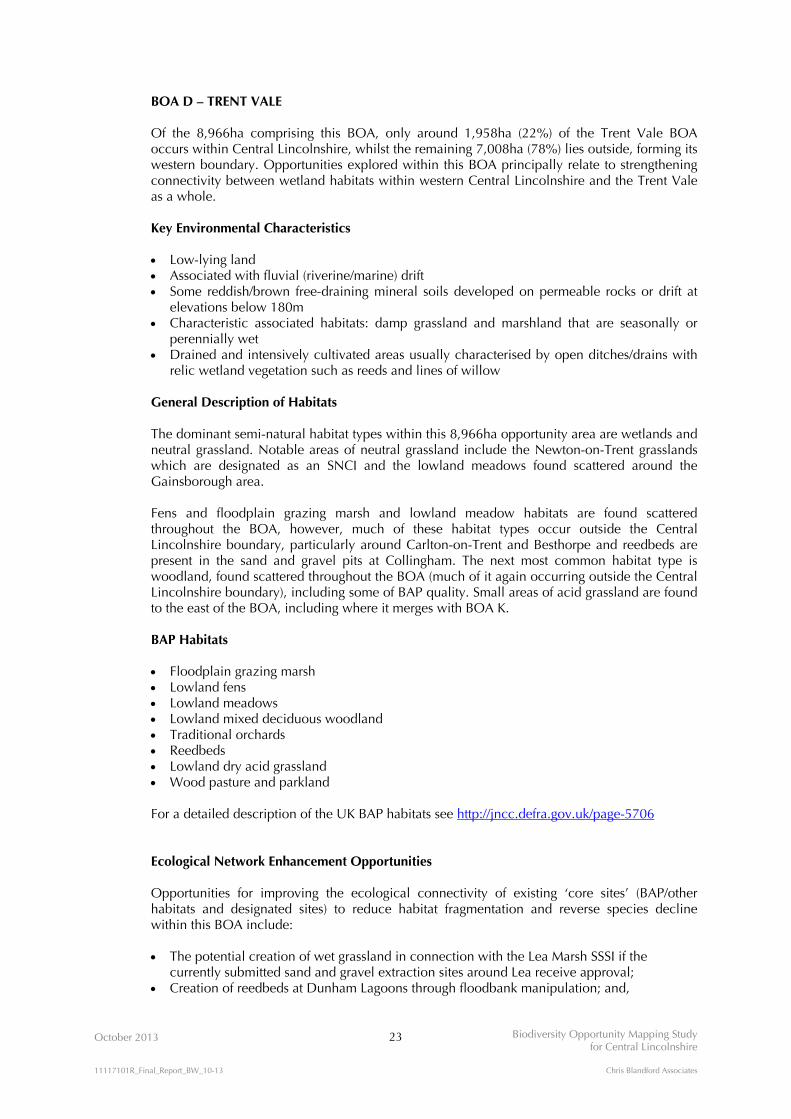
Heathland & Acid Grassland Habitat Opportunity Mapping
3.2.10 The Heathland & Acid Grassland Habitat Opportunity Mapping for Central Lincolnshire is
shown on Figure 3.3.
3.2.11 The existing habitats comprise:
Lowland heathland; and, Lowland dry acid grassland.
3.2.12 Targeted opportunity areas comprise:
200m heathland / acid grassland buffers; Plantation woodlands on superficial acidic soils deposits; and, Permitted and submitted (sands and gravels) minerals and waste sites.
3.2.13 Soils most suitable for heathland / acid grassland habitat creation are mapped to provide the
broad context for defining the Heathland / Acid Grassland BOAs. The Heathland / Acid
Grassland BOA boundaries were drawn to encompass:
Soils identified as having potential for heathland / acid grassland creation or restoration; All existing sites of heathland / acid grassland; Coniferous (non- ancient) plantation woodland situated within suitable soils deposits; and, All targeted opportunity areas for the protection, enhancement, creation and extension of
heathland / acid grassland habitat.
OCTOBER 2013
KEY
FIGURE 3.3N
Reproduced by permission of Ordnance Survey on behalf of HMSO. © Crown copyright and database right 2012. All rights reserved. Ordnance Survey Licence number NK100017926
BIODIVERSITY OPPORTUNITY MAPPING STUDYFOR CENTRAL LINCOLNSHIRE
Sites including heathland 0 5 10 km
Heathland & Acid Grassland Habitat Opportunity Mapping
Central Lincolnshire boundary
Soil most likely suitable for heathland and acid grassland habitat creationAcid grassland
Heathland/Acid Grassland Biodiversity Opportunity Area
Mosaic Biodiversity Opportunity Area - heathland,acid grassland, wetland and woodland
Targeted opportunity areas for thecreation and restoration of:- heathland and acid grassland habitat- heathland and acid grassland buffer zones- linear heathland and acid grassland corridors- heathland and acid grassland stepping stones
This Figure includes relevant dataavailable at the time of the Study,and may not be exhaustive. The digital datasets have been usedin good faith without any modification or enhancement, and their accuracy cannot be guaranteed.
Habitats:
Opportunity Areas:

October 2013 17 Biodiversity Opportunity Mapping Study for Central Lincolnshire
11117101R_Final_Report_BW_10-13 Chris Blandford Associates
Calcareous Grassland Habitat Opportunity Mapping
3.2.14 The Calcareous Grassland Habitat Opportunity Mapping for Central Lincolnshire is shown on
Figure 3.4.
3.2.15 The existing habitats comprise:
Calcareous grassland.
3.2.16 Targeted opportunity areas comprise:
200m calcareous grassland buffers; Greenspace overlying calcareous bedrock; The Lincoln Eastern Bypass; and, Permitted and submitted (limestone) minerals and waste sites.
3.2.17 Soils most suitable for calcareous grassland habitat creation are mapped to provide the broad
context for defining the Calcareous Grassland BOAs. The Calcareous Grassland BOA
boundaries were drawn to encompass:
Soils identified as having potential for calcareous grassland creation or restoration; All existing sites of calcareous grassland; and, All targeted opportunity areas for the protection, enhancement, creation and extension of
calcareous grassland habitat.
3.3 Mapping Habitat Sensitivity
3.3.1 The application of both GIS-based mapping and expert knowledge gained through the
workshops may identify opportunities for the creation of more than one type of habitat for a
given area of land. In an attempt, therefore, to try and rank which (habitat creation)
opportunities should be considered in preference to another, the Study provides an initial
ranking based on the relative resilience and sensitivities of each of the broad habitat types. The
ranking has been undertaken using the site quality criteria described in A Nature Conservation
Review13 and within the habitat descriptions of Lincolnshire’s BAP. The ranking of habitat
sensitivity has therefore been developed using criteria that includes:
Size: a measure of viability and therefore a particular site’s ability to support the range of
species typically found within that habitat type; Diversity: a measure of differences in climate, topography, geology, derived soils and land-
use and management; Naturalness: a measure of modification in relation to human influence; Rarity: including the rarity of the species that such habitats support; and,
13 Ratcliffe, D. (1977). A Nature Conservation Review: The selection of biological sites of national importance to nature conservation in Britain. CUP.

OCTOBER 2013
KEY
FIGURE 3.4N
Reproduced by permission of Ordnance Survey on behalf of HMSO. © Crown copyright and database right 2012. All rights reserved. Ordnance Survey Licence number NK100017926
BIODIVERSITY OPPORTUNITY MAPPING STUDYFOR CENTRAL LINCOLNSHIRE
0 5 10 kmCentral Lincolnshire boundary
Calcareous GrasslandHabitat Opportunity Mapping
Calcareous GrasslandBiodiversity Opportunity Area
Targeted opportunities for thecreation and restoration of:- calcareous grassland habitat- calcareous grassland buffer zones- linear calcareous grassland corridors- calcareous grassland stepping stones
Soil most suitable for calcareousgrassland habitat creationCalcareous grassland
This Figure includes relevant dataavailable at the time of the Study,and may not be exhaustive. The digital datasets have been usedin good faith without any modification or enhancement, and their accuracy cannot be guaranteed.
Habitats:
Opportunity Areas:

October 2013 18 Biodiversity Opportunity Mapping Study for Central Lincolnshire
11117101R_Final_Report_BW_10-13 Chris Blandford Associates
Fragility: a measure of habitat sensitivity to land management practices either on the habitat itself, or in close approximation to it;
3.3.2 It should be stressed that this is something of a coarse filter, intended to provide an initial
ranking based on broad habitat types. The ranking is a means of managing the process of
identifying and mapping opportunities, which may require refinement and site specific
judgements on a case by case basis, once opportunities are brought forward as potential
projects. As a general rule, however, the process of ranking opportunities on the basis of
habitat sensitivity was undertaken on the following basis:
Highest Sensitivity – heathland, neutral (lowland meadow), acid and calcareous grasslands: these are the rarest habitat types to be found in Central Lincolnshire. The existing resource tends to be highly fragmented, restricted in its distribution due to their requirement for specific land type conditions and can, arguably, be highly vulnerable to external environmental influences such as nutrient enrichment and spray drift. Similarly, changes in agricultural practices over the last 1-200 yrs have had a direct effect on both the extent and the quality of these open habitat types. Moreover, minimum patch sizes of around 30ha. is considered appropriate for new heathland creation. These habitat types are therefore considered to be a priority for protection, restoration and extension;
Medium Sensitivity – wetlands: although it is recognised that highly specialised wetland habitats (e.g. acid bog habitat) require very specific conditions, the majority of wetland habitat types in Central Lincolnshire, including wet neutral grassland (floodplain grazing marsh) can generally be created in a wide variety of locations, dependent on hydrological requirements. They are all, however, susceptible to degradation through changes in water availability, point and diffuse pollution, and adjacent land management; and,
Lower Sensitivity – woodlands: Whilst the quality of woodlands can be influenced by
external factors in the same way as the broad habitats discussed above, these influences may be more tempered and absorbed. With respect to woodland creation, therefore, the selection of appropriate species for a given set of soil and hydrological conditions is the primary consideration. Moreover, woodland creation may be better achieved through natural regeneration, rather than new planting, as the species mix will be self-selecting for a given set of conditions and may also help to protect against the spread of pests and diseases currently affecting a range of tree species (either by reducing the chance of introducing diseased specimens into areas that are currently unaffected or through natural resilience in the existing seedbank).
3.3.3 It is acknowledged that there are likely to be anomalies in this process; for example, there may
be woodland sites that, for a variety of reasons, are more vulnerable to change, than certain
grassland sites. These will need to be identified once the feasibility of delivering a biodiversity
opportunity is being tested.

October 2013 19 Biodiversity Opportunity Mapping Study for Central Lincolnshire
11117101R_Final_Report_BW_10-13 Chris Blandford Associates
3.4 Biodiversity Opportunity Area Descriptions
BOA A – GAINSBOROUGH WOODLANDS All of the 3,196ha of the Gainsborough Woodlands BOA lies within Central Lincolnshire. The opportunities explored within this BOA principally relate to the protection of, and increases in extent to, the woodlands surrounding Gainsborough. Key Environmental Characteristics
Heavy, poorly draining land Associated with base-rich loamy and clayey soils developed on soft clay and chalky till General Description of Habitats The dominant semi-natural habitat type within this 3,196ha opportunity area is woodland. This includes several Planted Ancient Woodland Sites (PAWS) and Ancient Semi-Natural Woodland sites (ASNW) which are of BAP quality. The next most common habitat type present is ‘greenspace’ managed as parks and gardens, including a large golf course to the north of the BOA. There are small areas of wetlands and neutral grasslands, mainly to the south of Gainsborough and where this BOA merges with BOA D. BAP Habitats
Lowland mixed deciduous woodland Lowland meadows Floodplain grazing marsh Wet woodland Traditional orchards For a detailed description of the UK BAP habitats see http://jncc.defra.gov.uk/page-5706
Ecological Network Enhancement Opportunities Opportunities for improving the ecological connectivity of existing ‘core sites’ (BAP/other habitats and designated sites) to reduce habitat fragmentation and reverse species decline within this BOA include: Creation of woodland corridors to link ancient woodland sites; Creation of woodland buffer zones around ancient woodland sites; Restoration of ancient woodland sites through selective felling of conifer plantations
(restoration of ancient woodland on Plantation Ancient Woodland Sites (PAWS)); Restoration and management of hedgerows by gapping up, laying, planting of new
hedgerow trees and coppicing; and, Restoration of woodland habitats within ‘greenspace’ through sympathetic management.

October 2013 20 Biodiversity Opportunity Mapping Study for Central Lincolnshire
11117101R_Final_Report_BW_10-13 Chris Blandford Associates
BOA B – WOODLANDS EAST OF LINCOLN Approximately 9,769ha (55%) of the Woodlands East of Lincoln BOA lies within Central Lincolnshire, whilst 7,992ha (45%), extends beyond the Central Lincolnshire boundary to the east. The opportunities explored within this BOA principally relate to increasing the connectivity between the woodlands that comprise the Lincolnshire Limewoods as a whole. Key Environmental Characteristics Heavy, poorly draining land Associated with base-rich loamy and clayey soils developed on soft clay and chalky till Also includes variable small amounts of sandy drift and peat covered glacial till close to the
River Witham General Description of Habitats The dominant semi-natural habitat type within this 17,761ha opportunity area is woodland. The woodlands include several Planted Ancient Woodland Sites (PAWS) and Ancient Semi-Natural Woodland sites (ASNW) which are of BAP quality. Neutral grassland, in particular linear lowland meadow sites are also common throughout the BOA. A small number of wetland habitats are found along the River Witham and Barlings Eau where this BOA merges with BOA G. Other habitats present include ‘greenspace’ managed as parks and gardens and one heathland site to the south of the BOA around Woodhall Spa. BAP Habitats Lowland mixed deciduous woodland Lowland meadows Floodplain grazing marsh Wet woodland Traditional orchards Lowland fens Lowland heathland Purple moor grass and rush pastures For a detailed description of the UK BAP habitats see http://jncc.defra.gov.uk/page-5706 Ecological Network Enhancement Opportunities Opportunities for improving the ecological connectivity of existing ‘core sites’ (BAP/other habitats and designated sites) to reduce habitat fragmentation and reverse species decline within this BOA include: Creation of hedgerows (linear corridors) to connect the individual woodlands comprising
the Bardney Limewoods SSSI with one another, as well as other (non-SSSI) woodland; Creation of field corner woodland copses to create woodland stepping stones; Creation of woodland buffers around each woodland unit of Bardney Limewoods and
Wickenby Woods SSSIs; Creation of hedgerows, tree belts (linear corridors) and woodland blocks to connect the
Bardney Limewoods SSSI woodlands with Wickenby Wood SSSI; Creation of hedgerows, tree belts (linear corridors) and woodland blocks to connect the
Bardney Limewoods SSSI woodlands with the ancient woodlands to the south around Potterhanworth; and,
Creation of hedgerows, tree belts (linear corridors) and woodland blocks to connect the ancient woodlands to the north and east of Woodhall Spa (lying outside the Central Lincolnshire boundary) with the Bardney Limewoods SSSI woodlands.

October 2013 21 Biodiversity Opportunity Mapping Study for Central Lincolnshire
11117101R_Final_Report_BW_10-13 Chris Blandford Associates
As identified from the Lincolnshire Limewoods Project14:
Restoration of ancient woodland sites through selective felling of conifer plantations
(restoration of ancient woodland on Plantation Ancient Woodland Sites (PAWS)); Widening of narrow woodland rides; Retention of standing and lying dead wood in situ; Creation of woodland belts linking adjacent woods ; Creation of hedgerows with minimum 60% blackthorn adjacent to and linking woods with
brown hairstreak colonies; Management of hedgerows by rotational flailing/laying/coppicing on a 2-5 year cycle with
no more than 30% cut in any year in core brown hairstreak areas; Retention of existing mature trees; Planting of new oak, ash15, elm, wild service, small-leaved lime, crab apple, wild cherry
and holly trees within existing hedgerows; Creation of field corner woodlands (copses) and some planting of new trees around ponds,
where this is appropriate; and, Creation of new woodland within 250m-500m of existing broad-leaved woodland.
For more information on the Lincolnshire Limewoods Project, including details of habitat creation and management projects visit http://microsites.lincolnshire.gov.uk/limewoods/about/
14 ESL (Ecological Services) Ltd (2008) Wildlife Corridors in the Lincolnshire Limewoods: Habitat Creation Opportunities and Constraints Map. 15 At the time of writing this report, it is not currently possible to plant ash due to the spread of Chalara (ash dieback disease) which has resulted in the imposition of a Plant Health Order prohibiting all imports of ash seeds, plants and trees, and all internal movement of ash seeds, plants and trees).

October 2013 22 Biodiversity Opportunity Mapping Study for Central Lincolnshire
11117101R_Final_Report_BW_10-13 Chris Blandford Associates
BOA C – RIVER ANCHOLME The River Ancholme BOA within Central Lincolnshire is measured at some 374ha, however, this represents only a small fraction of the total catchment of the River Ancholme, which extends to the north before discharging to the Humber estuary. The opportunities explored within this BOA principally relate to upstream catchment management. Key Environmental Characteristics Low-lying land Associated with fluvial (riverine/marine) drift Characteristic associated habitats: wetlands more or less permanently waterlogged,
including swamp and fen Drained areas usually characterised by open ditches/drains with relic wetland vegetation
such as reeds and lines of willow General Description of Habitats The dominant semi-natural habitat types within this 374ha opportunity area (within Central Lincolnshire) are small isolated woodland blocks scattered throughout the BOA and wetlands to the west of North Kelsey, within an otherwise intensively farmed landscape. Outside the Central Lincolnshire boundary, to the north, fens, heathland and acid grassland habitats are found on Wrawby Moor, where this BOA merges with the northern extent of BOA J. BAP Habitats Floodplain grazing marsh Lowland fens Lowland heathland Lowland dry acid grassland Purple moor grass and rush pastures Traditional orchards For a detailed description of the UK BAP habitats see http://jncc.defra.gov.uk/page-5706 Ecological Network Enhancement Opportunities Opportunities for improving the ecological connectivity of existing ‘core sites’ (BAP/other habitats and designated sites) to reduce habitat fragmentation and reverse species decline within this BOA include: Creation of a mosaic of wet grassland, reedbeds and wet woodland in the valley; Restoration of 'naturalised' channel characteristics through the removal of in-channel
obstructions; and, Creation of buffers around wetland habitats, including the banks of the River Ancholme,
using targeted environmental land management schemes, to ameliorate the effects of intensive agriculture.
October 2013 23 Biodiversity Opportunity Mapping Study for Central Lincolnshire
11117101R_Final_Report_BW_10-13 Chris Blandford Associates
BOA D – TRENT VALE Of the 8,966ha comprising this BOA, only around 1,958ha (22%) of the Trent Vale BOA occurs within Central Lincolnshire, whilst the remaining 7,008ha (78%) lies outside, forming its western boundary. Opportunities explored within this BOA principally relate to strengthening connectivity between wetland habitats within western Central Lincolnshire and the Trent Vale as a whole. Key Environmental Characteristics Low-lying land Associated with fluvial (riverine/marine) drift Some reddish/brown free-draining mineral soils developed on permeable rocks or drift at
elevations below 180m Characteristic associated habitats: damp grassland and marshland that are seasonally or
perennially wet Drained and intensively cultivated areas usually characterised by open ditches/drains with
relic wetland vegetation such as reeds and lines of willow General Description of Habitats The dominant semi-natural habitat types within this 8,966ha opportunity area are wetlands and neutral grassland. Notable areas of neutral grassland include the Newton-on-Trent grasslands which are designated as an SNCI and the lowland meadows found scattered around the Gainsborough area. Fens and floodplain grazing marsh and lowland meadow habitats are found scattered throughout the BOA, however, much of these habitat types occur outside the Central Lincolnshire boundary, particularly around Carlton-on-Trent and Besthorpe and reedbeds are present in the sand and gravel pits at Collingham. The next most common habitat type is woodland, found scattered throughout the BOA (much of it again occurring outside the Central Lincolnshire boundary), including some of BAP quality. Small areas of acid grassland are found to the east of the BOA, including where it merges with BOA K. BAP Habitats Floodplain grazing marsh Lowland fens Lowland meadows Lowland mixed deciduous woodland Traditional orchards Reedbeds Lowland dry acid grassland Wood pasture and parkland For a detailed description of the UK BAP habitats see http://jncc.defra.gov.uk/page-5706
Ecological Network Enhancement Opportunities Opportunities for improving the ecological connectivity of existing ‘core sites’ (BAP/other habitats and designated sites) to reduce habitat fragmentation and reverse species decline within this BOA include: The potential creation of wet grassland in connection with the Lea Marsh SSSI if the
currently submitted sand and gravel extraction sites around Lea receive approval; Creation of reedbeds at Dunham Lagoons through floodbank manipulation; and,

October 2013 24 Biodiversity Opportunity Mapping Study for Central Lincolnshire
11117101R_Final_Report_BW_10-13 Chris Blandford Associates
Creation of buffers around wetland habitats, including the banks of the River Trent and its tributaries, using targeted environmental land management schemes, to ameliorate the effects of intensive agriculture. Outside the Central Lincolnshire boundary, opportunities improving the ecological connectivity include:
Creation of wetland habitats as part of restoration plan for Rampton Quarry; Creation of wetland and grassland habitats as part of Sturton le Steeple Quarry restoration; Creation of new wet grassland/grazing marsh habitats to extend the existing resource at
Beckingham Marshes; and, Creation of reedbed complexes around Sutton on Trent.

October 2013 25 Biodiversity Opportunity Mapping Study for Central Lincolnshire
11117101R_Final_Report_BW_10-13 Chris Blandford Associates
BOA E – RIVER TILL AND FOSSDYKE NAVIGATION All 4,463ha of the River Till and Fossdyke Navigation falls within Central Lincolnshire. The opportunities explored within this BOA principally relate to water quality and flow regime enhancements, in line with WFD requirements to improve the ecological quality of the catchment. Additionally, opportunities to improve flood risk management through habitat enhancements are also considered. Key Environmental Characteristics Reddish/brown, free-draining mineral soils developed on permeable rocks or drift at
elevations below 180m Some areas have poor draining base-rich loamy and clayey soils developed on soft clay and
chalky till Characteristic associated habitats: wet grassland and marshland which are seasonally or
periodically inundated by water Seasonal waterlogging is the main constraint to agricultural production – however in most
areas these soils will be intensively cultivated and used for cereal growing General Description of Habitats This 4,463ha opportunity area contains a mosaic of wetland, neutral grassland, woodland, acid grassland and heathland habitats, particularly to the south where it merges with BOA K. Reedbeds are present in the Swanpool area and standing water bodies include the Swanholme Lakes, Hartsholme Lake and Ballast Holes which are found occurring with wet woodland. Also present in the Lincoln area are large areas of ‘greenspace’ including parks and gardens, arable, scrub and tall ruderal habitats. Woodland is the main habitat type found north-west of Lincoln and along the length of the River Till, including a mixture of ancient and plantation woodland, some of which is BAP quality. BAP Habitats Lowland mixed deciduous woodland Eutrophic standing water Wet woodland Traditional orchards Lowland dry acid grassland Lowland heathland Lowland meadows Reedbeds Floodplain grazing marsh Wood pasture and parkland Lowland fens
For a detailed description of the UK BAP habitats see http://jncc.defra.gov.uk/page-5706 Ecological Network Enhancement Opportunities Opportunities for improving the ecological connectivity of existing ‘core sites’ (BAP/other habitats and designated sites) to reduce habitat fragmentation and reverse species decline within this BOA include:
Restoration of 'naturalised' river channels where this is considered feasible and/or
appropriate, through the removal of in-channel obstructions and the introduction of features that enhance flow heterogeneity;
Partial restoration of pasture within the Till washland;

October 2013 26 Biodiversity Opportunity Mapping Study for Central Lincolnshire
11117101R_Final_Report_BW_10-13 Chris Blandford Associates
Creation of a mosaic of wet woodland, reedbed and wet grassland in the upper reaches of the River Till;
Restoration of water quality within the River Till and Fossdyke navigation using phosphate stripping at wastewater treatment works, where this may be applicable;
Creation of new reedbeds to extend the existing resource at Swanpool and to aid flood risk management; and,
Creation of buffers around wetland habitats, including the banks of the River Till and its tributaries, using targeted environmental land management schemes, to ameliorate the effects of intensive agriculture.

October 2013 27 Biodiversity Opportunity Mapping Study for Central Lincolnshire
11117101R_Final_Report_BW_10-13 Chris Blandford Associates
BOA F – RIVER BRANT AND UPPER WITHAM Of the 5,478ha comprising the River Brant and Upper Witham BOA, approximately 78% (4,277ha) lies within Central Lincolnshire, with the remaining 22% (1201ha) lies to the south. The opportunities explored within this BOA principally relate to water quality and flow regime enhancements, in line with WFD requirements to improve the ecological quality of the catchment. Additionally, opportunities to improve flood risk management through habitat enhancements are also considered. Key Environmental Characteristics Reddish/brown, free-draining mineral soils developed on permeable rocks or drift at
elevations below 180m Some areas have poor draining base-rich loamy and clayey soils developed on soft clay and
chalky till Characteristic associated habitats: wet grassland and marshland habitats which are
seasonally or periodically inundated by water Seasonal waterlogging is the main constraint to agricultural production – however in most
areas these soils will be intensively cultivated and used for cereal growing General Description of Habitats This 5,478ha opportunity area contains a mosaic of wetland, neutral grassland and woodland habitats. Woodland is found scattered throughout the BOA, including some likely to be of BAP quality in Boultham Park. Neutral grasslands found to the north of the BOA are mostly non-BAP quality with a few scattered lowland meadow sites. Also present to the north of the BOA is a large amount of ‘greenspace’ including allotments, amenity grassland, arable and improved grassland habitats. A limited number of floodplain grazing marsh sites can be found along the River Witham, in particular east of Balderton (outside the Central Lincolnshire boundary). BAP Habitats Lowland mixed deciduous woodland Lowland meadows Floodplain grazing marsh Traditional orchards Wet woodland Wood pasture and parkland For a detailed description of the UK BAP habitats see http://jncc.defra.gov.uk/page-5706 Ecological Network Enhancement Opportunities Opportunities for improving the ecological connectivity of existing ‘core sites’ (BAP/other habitats and designated sites) to reduce habitat fragmentation and reverse species decline within this BOA include: Restoration of floodplain grazing marsh near Haddington; Creation of wet woodland at suitable locations along both the River Brant and Upper
Witham; Creation of riparian buffer strips of wet grassland or wet woodland along the channel of the
River Brant; Restoration of 'naturalised' channel characteristics of the River Brant through removal of in-
channel obstructions; Restoration of the River Brant through de-silting;

October 2013 28 Biodiversity Opportunity Mapping Study for Central Lincolnshire
11117101R_Final_Report_BW_10-13 Chris Blandford Associates
Creation of in-channel features such as riffle-pool sequences and in-channel deflectors in the River Brant;
Restoration of the River Brant using phosphate stripping at wastewater treatment works; Creation of wet woodland as a mechanism for controlling silt deposition into watercourses;
and, Creation of new upstream washlands, as an extension of the existing Brant washland.

October 2013 29 Biodiversity Opportunity Mapping Study for Central Lincolnshire
11117101R_Final_Report_BW_10-13 Chris Blandford Associates
BOA G – LOWER WITHAM PEATLANDS AND BARLINGS EAU Virtually all of the 7,199ha comprising the Lower Witham Peatlands and Barlings Eau BOA occurs within Central Lincolnshire. The opportunities explored within this BOA principally relate to the conservation of peatland soils and water quality and flow regime enhancements, in line with WFD requirements to improve the ecological quality of the catchment. Additionally, opportunities to improve flood risk management through habitat enhancements are also considered. Key Environmental Characteristics Low-lying land Associated with fluvial (riverine/marine) drift To the north around Snelland the land is heavy and associated with base-rich loamy and
clayey soils developed on soft clay and chalky till Characteristic associated habitats: permanently or seasonally waterlogged including swamp,
fen, wet grassland and marshland Drained and intensively cultivated areas usually characterised by open ditches/drains with
relic wetland vegetation such as reeds and lines of willow General Description of Habitats The dominant semi-natural habitat type within this 7,199ha opportunity area is wetland. Areas of floodplain grazing marsh are concentrated east of Lincoln along the River Witham and Barlings Eau, and along the embankments of the Metheringham Delph. Swamp and standing water bodies are found north and west of Canwick. Also present to the west of the BOA around Lincoln is a concentration of acid and neutral grassland habitats, mostly of non-BAP quality. A small amount of woodland is found scattered throughout the BOA, including some semi-natural ancient and BAP quality sites where this BOA merges with BOA B. Other notable habitats present include brownfield sites, cemeteries and parks and gardens broadly categorised as ‘greenspace’. BAP Habitats Floodplain grazing marsh Lowland mixed deciduous woodland Lowland meadows Lowland dry acid grassland Wet woodland Traditional orchards For a detailed description of the UK BAP habitats see http://jncc.defra.gov.uk/page-5706 Ecological Network Enhancement Opportunities Opportunities for improving the ecological connectivity of existing ‘core sites’ (BAP/other habitats and designated sites) to reduce habitat fragmentation and reverse species decline within this BOA include: Restoration of relic peatlands to provide landscape-scale mosaic of wetland habitats to
connect with the Fens Waterway Link; Creation of a new washland between Cherry Willingham and Washingborough; Creation of reedbeds around Potterhanworth Booths; Creation of wet woodland (alder carr) in the upper reaches of the Barlings Eau to extend the
existing resource; Restoration of 'naturalised' river channels along the River Witham and Barlings Eau through
removal of in-channel obstructions;

October 2013 30 Biodiversity Opportunity Mapping Study for Central Lincolnshire
11117101R_Final_Report_BW_10-13 Chris Blandford Associates
Restoration of the floodplain adjacent to Upper Langwith Beck; Restoration of floodplain adjacent to the Branston Delph; Creation of buffers around wetland habitats using targeted environmental land management
schemes, to ameliorate the effects of intensive agriculture; Creation of grassland buffers adjacent to agricultural field drains to ameliorate the effects of
agricultural run-off; Incorporation of surface water drainage attenuation ponds associated with the Lincoln
Eastern Bypass, as a component of a mosaic of small waterbodies (pondscape); Restoration of fenland habitats where feasible; and, Creation of ponds on agricultural land to restore the pondscape through targeted
environmental land management agreements.

October 2013 31 Biodiversity Opportunity Mapping Study for Central Lincolnshire
11117101R_Final_Report_BW_10-13 Chris Blandford Associates
BOA H – RIVER SLEA Of the 3,799ha comprising the River Brant and Upper Witham BOA, approximately 93% (3,541ha) lies within Central Lincolnshire, with the remaining 7% (257ha) extending outside the Central Lincolnshire boundary to both the west and east The opportunities explored within this BOA principally relate to water quality and flow regime enhancements, in line with WFD requirements to improve the ecological quality of the catchment. Additionally, opportunities to improve flood risk management through habitat enhancements are also considered. Key Environmental Characteristics Heavy, often poorly drained and associated with base-rich loamy and clayey soils
developed on soft clay and chalky till To the east from Anwick to Dogdyke the land is better described as low-lying and
associated with fluvial (riverine/marine) drift Characteristic associated habitats: permanently or seasonally waterlogged including swamp,
fen, wet grassland and marshland Drained and intensively cultivated areas usually characterised by open ditches/drains with
relic wetland vegetation such as reeds and lines of willow General Description of Habitats This 3,799ha opportunity area contains a mosaic of wetland, neutral grassland and woodland habitats. Small pockets of floodplain grazing marsh, fens, reedbeds and open water bodies are found scattered throughout the BOA. The woodland resource also mainly exists as small scattered fragments, and includes some habitats which are likely to be of BAP quality. The neutral grassland resource is concentrated west of Sleaford and is mainly non-BAP quality. Other habitats present include some fragments of calcareous grassland, mainly around the South Rauceby/Wilsford area where this BOA merges with BOA L. BAP Habitats Floodplain grazing marsh Lowland calcareous grassland Lowland mixed deciduous woodland Lowland meadows Lowland fens Traditional orchards Wet woodland Purple moor grass and rush pastures Reedbeds Wood pasture and parkland For a detailed description of the UK BAP habitats see http://jncc.defra.gov.uk/page-5706 Ecological Network Enhancement Opportunities Opportunities for improving the ecological connectivity of existing ‘core sites’ (BAP/other habitats and designated sites) to reduce habitat fragmentation and reverse species decline within this BOA include: Creation of riparian wet woodland, where this is deemed feasible by specialist experts in
this form of habitat creation; Creation of neutral grassland at Mareham Pastures to expand the existing resource, in
connection with the Sleaford southern extension; Creation of wet meadows along the channel of the River Slea;

October 2013 32 Biodiversity Opportunity Mapping Study for Central Lincolnshire
11117101R_Final_Report_BW_10-13 Chris Blandford Associates
Restoration of 'naturalised' channel characteristics of the River Slea through removal of in-channel obstructions;
Restoration of the River Slea through de-silting; Creation of in-channel features such as riffle-pool sequences and in-channel deflectors in
the River Slea; Creation of buffers around wetland habitats using targeted environmental land management
schemes, to ameliorate the effects of intensive agriculture; Potential restoration of submitted minerals sites to the south of Sleaford to an open wetland
habitat mosaic, if they receive approval; and, Creation of a mosaic of wetland habitats along the length of the River Slea to link the
existing wetland habitat resource and restore naturalised floodplain characteristics.

October 2013 33 Biodiversity Opportunity Mapping Study for Central Lincolnshire
11117101R_Final_Report_BW_10-13 Chris Blandford Associates
BOA I – HEATHLAND/ACID GRASSLAND NORTH OF GAINSBOROUGH Of the 19,672ha comprising the Heathland / Acid Grassland north of Gainsborough BOA, approximately 27% (5,400ha) lies within Central Lincolnshire, with the remaining 73% (14,272ha) extending to the north, towards Scunthorpe. The opportunities explored within this BOA principally relate to the protection, conservation and extension of heathland and acid grassland habitats within the vicinity of Gainsborough. Key Environmental Characteristics
Light land Coversands Associated with impoverished (podzolic) soils, reddish/brown free-draining soils and
sandy/shallow acid brown soils developed on permeable rocks (mudstones, siltstones and sandstones) or sandy drift at elevations below 300m
Characteristic associated habitats: dry acidic grassland and dwarf shrub habitats i.e. heathland and moor
May be intensively cultivated Relic heathland habitats distinguished by an abundance of bracken and gorse, or planted
with conifers General Description of Habitats The dominant semi-natural habitat types within this 19,672ha opportunity area are woodland, heathland and acid grassland. A large proportion of the woodland resource, particularly in the Laughton Forest, is coniferous plantation. Deciduous woodland (some likely to be of BAP quality) is also found scattered throughout the BOA. Concentrations of lowland dry acid grassland, heathland and purple moor grass and rush pastures are found at Greetwell, Scotton and Messingham. Also common in these areas are wetland habitats, particularly fens and reedbeds. Outside the Central Lincolnshire boundary, other habitats present in the BOA include heathland and purple moor grass and rush pastures are found at Risby Warren, along with calcareous grassland, a small extent of scattered neutral grassland and some ‘greenspace’ areas managed as wood pasture and parkland. BAP Habitats Lowland dry acid grassland Lowland heathland Purple moor grass and rush pastures Lowland mixed deciduous woodland Reedbeds Traditional orchards Lowland fens Lowland calcareous grassland Floodplain grazing marsh Lowland meadows Wood pasture and parkland Lowland raised bog For a detailed description of the UK BAP habitats see http://jncc.defra.gov.uk/page-5706 Ecological Network Enhancement Opportunities Opportunities for improving the ecological connectivity of existing ‘core sites’ (BAP/other habitats and designated sites) to reduce habitat fragmentation and reverse species decline within this BOA include:

October 2013 34 Biodiversity Opportunity Mapping Study for Central Lincolnshire
11117101R_Final_Report_BW_10-13 Chris Blandford Associates
Restoration of heathland and/or acid grassland habitats through the selective felling of
coniferous woodland plantations (where these are not PAWS plantations); Restoration of heathland and acid grassland habitats through a combination of techniques
which may include: the maintenance of areas of bare ground, brash laying, seeding and control of self-sown tree seedlings;
Potential restoration of submitted minerals sites to an open heathland/acid grassland habitat mosaic, if sites receive approval;
Creation of a mosaic of open heathland, acid grassland and wetland (e.g. acidic bog) habitats to reinforce and extend the coverage of the existing resource; and,
Creation of open habitat buffers around the existing extent of heathland and acid grassland habitats to protect them from the potential effects of agricultural spray drift.

October 2013 35 Biodiversity Opportunity Mapping Study for Central Lincolnshire
11117101R_Final_Report_BW_10-13 Chris Blandford Associates
BOA J – HEATHLAND/ACID GRASSLAND AROUND MARKET RASEN Of the 16,385ha comprising the Heathland / Acid Grassland around Market Rasen BOA, approximately 78% (12,784ha) lies within Central Lincolnshire, with the remaining 12% (3,601ha) extending to the north and south. The opportunities explored within this BOA principally relate to the protection, conservation and extension of heathland and acid grassland habitats within the vicinity of Gainsborough. Key Environmental Characteristics Light land Associated with impoverished (podzolic) soils, reddish/brown free-draining soils and
sandy/shallow acid brown soils developed on permeable rocks (mudstones, siltstones and sandstones) or sandy drift at elevations below 300m
Characteristic associated habitats: dry acidic grassland and dwarf shrub habitats i.e. heathland and moor
May be intensively cultivated Relic heathland habitats distinguished by an abundance of bracken and gorse, or planted
with conifers General Description of Habitats The dominant semi-natural habitat types within this 16,385ha opportunity area are woodland, heathland and acid grassland. A large proportion of the woodland resource, particularly around Market Rasen, is coniferous plantation. However there are also ancient semi-natural and BAP quality woodland sites concentrated in this area, as well as being scattered throughout the BOA. Concentrations of BAP quality acid grassland and heathland are found around Nettleton, Normanby le Wold and Market Rasen. Other habitats present include neutral and calcareous grassland, with the best quality sites concentrated around Nettleton and Normanby le Wold, and a limited number of wetland sites, parks and gardens. BAP Habitats Lowland heathland Lowland dry acid grassland Lowland meadows Lowland mixed deciduous woodland Purple moor grass and rush pastures Lowland calcareous grassland Lowland fens Traditional orchards Wood pasture and parkland Floodplain grazing marsh For a detailed description of the UK BAP habitats see http://jncc.defra.gov.uk/page-5706 Ecological Network Enhancement Opportunities Opportunities for improving the ecological connectivity of existing ‘core sites’ (BAP/other habitats and designated sites) to reduce habitat fragmentation and reverse species decline within this BOA include: Restoration of heathland and/or acid grassland habitats through the selective felling of
coniferous woodland plantations (where these are not PAWS plantations); Restoration of heathland and acid grassland habitats through a combination of techniques
which may include: the maintenance of areas of bare ground, brash laying, seeding and control of self-sown tree seedlings;

October 2013 36 Biodiversity Opportunity Mapping Study for Central Lincolnshire
11117101R_Final_Report_BW_10-13 Chris Blandford Associates
Potential restoration of submitted minerals sites to an open heathland/acid grassland habitat mosaic, if sites receive approval;
Creation of a mosaic of open heathland, acid grassland and wetland (e.g. acidic bog) habitats to reinforce and extend the coverage of the existing resource; and,
Creation of open habitat buffers around the existing extent of heathland and acid grassland habitats to protect them from the potential effects of agricultural spray drift.

October 2013 37 Biodiversity Opportunity Mapping Study for Central Lincolnshire
11117101R_Final_Report_BW_10-13 Chris Blandford Associates
BOA K – MOSAIC SOUTH-WEST OF LINCOLN Of the 12,722ha comprising the mosaic habitat south-west of Lincoln BOA, approximately 82% (10,410ha) lies within Central Lincolnshire, with the remaining 18% (2,312ha) extending to the west. The opportunities explored within this BOA principally relate to the protection, conservation and extension of a mosaic of habitats around the periphery of Lincoln, the Witham Valley Country Park and potential for minerals sites restorations further to the west. Key Environmental Characteristics Heavy, often poorly draining land associated with base-rich loamy and clayey soils
developed on clay and chalky till, or reddish/brown free-draining soils developed on permeable rocks or drift at elevations below 180m
Characteristic associated habitats: damp neutral grassland and marshland However, due to localised deposits of sand and gravel in this area the land is able to
support acid grassland and heathland habitats more typical of free-draining acidic soils General Description of Habitats This 12,722ha opportunity area contains a mosaic of woodland, wetland, acid grassland and heathland habitats. Much of the woodland resource is likely to be of BAP quality, including ancient, wet and lowland mixed deciduous woodland. The coniferous plantation woodland resource is also quite large, but much has originated on ancient woodland sites- notably Stapleford Woods. Acid grassland and heathland sites are found scattered throughout the BOA, often occurring in a mosaic with woodland and wetland habitats in disused mineral extraction sites or on planted woodland sites. The majority of wetland habitats that occur are standing water, running water and swamp/reedbeds which are found concentrated in the Whisby Nature and Hartsholme Country Park, around Swanpool and West Common. Neutral grassland and ‘greenspace’ is abundant in and around Lincoln, and includes areas such as parks, gardens, allotments, cemeteries, scrub and meadows. BAP Habitats Lowland mixed deciduous woodland Lowland dry acid grassland Lowland fens Lowland heathland Lowland meadows Eutrophic standing water Purple moor grass and rush pastures Reedbeds Wet woodland Traditional orchards Wood pasture and parkland Floodplain grazing marsh For a detailed description of the UK BAP habitats see http://jncc.defra.gov.uk/page-5706
Ecological Network Enhancement Opportunities Opportunities for improving the ecological connectivity of existing ‘core sites’ (BAP/other habitats and designated sites) to reduce habitat fragmentation and reverse species decline within this BOA include: Creation of heathland stepping stones (through a combination of heathland restoration, re-
establishment on areas of current plantation woodland and new habitat creation) in the Spalford, North Scarle and Besthorpe area towards Whisby;
October 2013 38 Biodiversity Opportunity Mapping Study for Central Lincolnshire
11117101R_Final_Report_BW_10-13 Chris Blandford Associates
Creation of new wetland habitat mosaics around Swanpool, as integral components for the development of the SUE and its associated flood risk management strategy;
Restoration of PAWS through the selective felling of conifers; Creation of new open grassland and/or wetland habitats as key components of quarry
restoration; Creation of buffers around existing habitat resource to reduce the effects of intensive
agriculture; and, Creation of semi-natural habitats within the urban extent of North Hykeham to provide
linkages between greenspaces and to increase permeability for wildlife.

October 2013 39 Biodiversity Opportunity Mapping Study for Central Lincolnshire
11117101R_Final_Report_BW_10-13 Chris Blandford Associates
BOA L – CALCAREOUS GRASSLAND SOUTH OF LINCOLN Of the 37,856ha comprising the calcareous grassland south of Lincoln BOA, approximately 75% (28,360ha) lies within Central Lincolnshire, with the remaining 25% (9,496ha) extending south, towards Grantham (outside the Central Lincolnshire boundary). The opportunities explored within this BOA principally relate to the protection, conservation and extension of calcareous grassland habitats within the central southern swathe of Central Lincolnshire. Key Environmental Characteristics Light land Associated with shallow, free-draining soils developed on limestone or chalk bedrock To the south from Wilsford to Humby (outside Central Lincolnshire) the land is heavier and
associated with base-rich loamy and clayey soils developed on soft clay and chalky till Characteristic associated habitats: dry grassland, usually with an abundance of fine leafed
grasses, low flowering herbs and/or bracken Stony soils with relic calcareous grassland may occur on steeper slopes in soft rock areas General Description of Habitats The dominant semi-natural habitat types within this 37,856ha opportunity area are woodland and calcareous grassland. Small fragments of woodland, mainly broadleaved, are found scattered throughout the BOA but do include some sites likely to be of BAP quality. There is also a number of large wood pasture and parkland sites, including those at Rauceby, Belton, Harmston and Branston (as well as at Belton, outside the Central Lincolnshire boundary). The calcareous grassland resource is mainly confined to a large number of road verges, which have been identified during the 'Life on the Verge' project and designated as Local Wildlife Sites. Besides that which is found on road verges, the largest extent of calcareous grassland on any one site is found at Greetwell quarry. A small number of neutral grassland and wetland sites are also present, concentrated mainly around Lincoln where this BOA merges with BOA G. Other habitats include a small extent of acid grassland and ‘greenspace’ – including brownfield sites, allotments, cemeteries, scrub, parks and gardens. BAP Habitats Lowland calcareous grassland Lowland mixed deciduous woodland Wood pasture and parkland Lowland fens Lowland meadows Floodplain grazing marsh Wet woodland Lowland dry acid grassland Traditional orchards For a detailed description of the UK BAP habitats see http://jncc.defra.gov.uk/page-5706 Ecological Network Enhancement Opportunities Opportunities for improving the ecological connectivity of existing ‘core sites’ (BAP/other habitats and designated sites) to reduce habitat fragmentation and reverse species decline within this BOA include: Creation of calcareous grassland linear corridors extending northwards from the High Dyke
corridor; Restoration of sub-optimal calcareous grassland habitats at RAF Barkston Heath and
Cranwell;

October 2013 40 Biodiversity Opportunity Mapping Study for Central Lincolnshire
11117101R_Final_Report_BW_10-13 Chris Blandford Associates
Restoration and management of road verges by introducing appropriate management e.g. cut and bale, scrub removal;
Creation and extension of calcareous grassland roadside verges through seeding and plug planting to aid colonisation and habitat contiguity;
Creation of calcareous grassland in connection with the Sleaford Sustainable Urban Extensions;
Creation of buffers adjacent to calcareous grassland habitats using targeted environmental land management schemes, to ameliorate the effects of intensive agriculture; and,
Restoration of relic calcareous grasslands through the creation of buffers to reduce to effects of spray drift and the introduction of appropriate grazing regimes.

October 2013 41 Biodiversity Opportunity Mapping Study for Central Lincolnshire
11117101R_Final_Report_BW_10-13 Chris Blandford Associates
BOA M – LINCOLNSHIRE WOLDS CALCAREOUS GRASSLAND Of the 27,928ha comprising the calcareous grassland south of Lincoln BOA, approximately 61% (17,025ha) lies within Central Lincolnshire, with the remaining 39% (10,903ha) extending outside Central Lincolnshire to both north and south. The opportunities explored within this BOA principally relate to the protection, conservation and extension of calcareous grassland habitats within the central southern swathe of Central Lincolnshire. Key Environmental Characteristics Light land Associated with shallow, free-draining drift soils developed on chalk bedrock Characteristic associated habitats: dry grassland, usually with an abundance of fine leafed
grasses, low flowering herbs and/or bracken Stony soils with relic calcareous grassland may occur on steeper slopes in soft rock areas General Description of Habitats The dominant semi-natural habitat types within this 27,928ha opportunity area are woodland, wood pasture and parkland, neutral grassland and calcareous grassland. Most noticeable is the series of woodlands, wood pasture and parklands running southwards from Habrough (outside the Central Lincolnshire boundary) to just north of Caistor. Very few of these woodlands are ancient and some are planted with conifers, but some may also be of BAP quality. The best quality grassland sites are concentrated around Nettleton, Risby and Normanby le Wold and there are also a number of important road verges. A small number of wetland sites are also present scattered throughout the BOA and a limited extent of acid grassland around Nettleton and Normanby le Wold where this BOA merges with BOA J. BAP Habitats Lowland mixed deciduous woodland Lowland calcareous grassland Lowland meadows Wood pasture and parkland Traditional orchards Lowland dry acid grassland Wet woodland Purple moor grass and rush pastures For a detailed description of the UK BAP habitats see http://jncc.defra.gov.uk/page-5706 Ecological Network Enhancement Opportunities Opportunities for improving the ecological connectivity of existing ‘core sites’ (BAP/other habitats and designated sites) to reduce habitat fragmentation and reverse species decline within this BOA include:
Creation of a mosaic of open habitat types that connect the existing semi-natural calcareous, neutral and acid grassland habitats, particularly south east of Caister, towards Walesby;
Restoration and management of road verges by introducing appropriate management e.g. cut and bale, scrub removal;
Creation and extension of calcareous grassland roadside verges through seeding and plug planting to aid colonisation and habitat contiguity;
Creation of buffers adjacent to calcareous grassland habitats using targeted environmental land management schemes, to ameliorate the effects of intensive agriculture; and,

October 2013 42 Biodiversity Opportunity Mapping Study for Central Lincolnshire
11117101R_Final_Report_BW_10-13 Chris Blandford Associates
Restoration of relic calcareous grasslands through the creation of buffers to reduce to effects of spray drift and the introduction of appropriate grazing regimes, particularly around Thorganby, Croxby and north of Swallow.

October 2013 43 Biodiversity Opportunity Mapping Study for Central Lincolnshire
11117101R_Final_Report_BW_10-13 Chris Blandford Associates
3.5 Schedule of Proposed Strategic Projects
3.5.1 Informed by the stakeholder consultation, a list of strategic projects considered to have
potential to contribute to the delivery of Biodiversity Opportunities has been identified and
presented in Table 3.1 and illustrated in Figure 3.6.
3.5.2 Figure 3.6 illustrates the extent of each of the identified strategic projects within the BOAs.
These areas identified are indicative and endeavour to show the broad area within which
practical, project-based, interventions should be focused in the first instance. In some
circumstances the project area aligns to the extent of the BOA (e.g. the River Till and Fossdyke
Navigation BOA and Project Area), whilst others focus on a specific area within the BOA (e.g.
the Market Rasen Heathlands Project Area is one area within the Heathland/Acid Grassland
around Market Rasen BOA. The extent of the project areas is based on a number of criteria
including:
The extent and relative fragility of the known habitat resource; The scope of existing projects; The area required to address specific ecological issues (e.g. addressing poor water quality
within a given catchment, or the protection of existing ecological resources in relation to planned growth); and,
The magnified influence that the delivery of small projects may have in relation to the protection and enhancement of the resource as a whole (i.e. large gains for relatively small input effort).
3.5.3 For the purposes of this Study, a ‘strategic’ project is one that is clearly of value to more than a
part of Central Lincolnshire and facilitates a landscape-scale approach to enhancing the
ecological network. The areas should, however, be considered as guidance intended to help
focus and scope feasibility studies and detailed project development. They should not result in
the exclusion of individual projects or initiatives that may arise outside these areas.
3.5.4 The Strategic Projects include both existing (e.g. the Lincolnshire Limewoods Project), as well
as proposed projects identified through the BOM process. Table 3.1 provides a broad rationale
and suite of objectives for each of the strategic projects, the delivery of which could be
achieved through the implementation of the relevant ecological enhancement opportunities set
out under each BOA in Section 3.4.
3.5.5 ‘Indicative Costs’ have been identified on the basis of estimated capital costs for the delivery of
the project objectives using cost bandings as follows:
Low - < £50k Medium - £50 - £500k High - £500k +

OCTOBER 2013
0 5 10 km
FIGURE 3.6NBIODIVERSITY OPPORTUNITY MAPPING STUDYFOR CENTRAL LINCOLNSHIRE Strategic Project Areas
for Central Lincolnshire
This Figure includes relevant data available at the time of the Study, and may not be exhaustive. The digital datasets have been used in good faith without any modification or enhancement, and their accuracy cannot be guaranteed.
B
G
J
M
L
H
F
K
D
A
I C
E
South of Lincoln Calcareous Grasslands
North Gainsborough Heathlands
South-West Lincoln Wetlandsand Heathlands
River Slea Wetlands
Market Rasen Heathlands
Lincolnshire Wolds Calcareous Grasslands
H
I
J
K
L
M
The BOAs represent the priority areasof opportunity within Central Lincolnshire for the restoration and creation of Biodiversity Action Plan (BAP) and otherhabitats. They are intended to be a spatial representation of the Lincolnshire BAPshabitat targets and are areas of opportunity, not constraint. The BOAs shown in the mapdo not necessarily include all BAP habitatin Central Lincolnshire, nor do they includeall the areas where habitat could exist.
Reproduced by permission of Ordnance Survey on behalf of HMSO. © Crown copyright and database right 2012. All rights reserved. Ordnance Survey Licence number NK100017926
River Ancholme
Calcareous Grassland South of Lincoln
Heathland/Acid GrasslandNorth of Gainsborough
Mosaic South-West of Lincoln
Woodlands East of Lincoln
Biodiversity Opportunity Areas (see Secton 3.4):
Gainsborough Woodlands
Trent Vale
River Till and Fossdyke NavigationRiver Brant and Upper WithamLower Witham Peatlandsand Barlings Eau
River Slea
Heathland/Acid Grasslandaround Market Rasen
Lincolnshire Wolds Calcareous Grassland
Trent Vale
River Till and Fossdyke Navigation
River Brant and Upper WithamWetlands
Lower Witham Peatlands
D
G
F
E
KEYCentral Lincolnshireboundary
Calcareous grassland
Heathland
Acid grassland
Wetlands
Neutral grassland
Woodland
Habitats:
Gainsborough Woodlands
River Ancholme Wetlands
Lincolnshire Limewoods
C
B
A
Strategic Project Areas:
(see Section 3.5)

October 2013 44
Biodiversity Opportunity Mapping Study for Central Lincolnshire
11117101R_Final_Report_BW_10-13 Chris Blandford Associates
Table 3.1 Schedule of Proposed Strategic Projects Proposed Strategic Project
Scope / Objectives Indicative Cost
Priority
A. Gainsborough Woodlands Project
The Gainsborough Woodlands project recognises the important woodland resource surrounding Gainsborough and the protection that they require in light of proposed growth around the town. Objectives:
To protect the existing woodlands To strengthen and extend the woodlands by creating woodland
linkages and strengthening the hedgerow network
Medium Medium. To be considered in relation to the effects that future housing allocation and projected population growth may have on the woodland resource
B. LincolnshireLimewoods Project (existing)
The Lincolnshire Limewoods Project has existed since 2005, delivering a Heritage Lottery funded programme of works until 2012. Project partners continue to work on a variety of projects including forestry and woodland management, grassland management, woodland creation, hedgerow management and species monitoring. The proposal seeks to reinforce and build on the work already achieved in this area. Objectives:
Promote sympathetic woodland management, restoration and expansion
Strengthening linkages between existing woodlands and associated habitats through the creation of appropriate habitats
Maintaining, strengthening and extending the hedgerow network.
Medium Medium. Structures and programmes of work are already in place to continue the management of existing, as well as the creation of new woodlands. Continuation of the works programme required in the longer term to ensure the quality of the woodlands and associated habitats are maintained.
C. River Ancholme Wetlands Project
The River Ancholme is currently graded as having ‘Moderate’ (approx. 80%) to ‘Poor’ (approx. 20%) ecological status within Central Lincolnshire, as assessed under WFD criteria. Given the rural nature of the catchment, this status may be due to diffuse agricultural pollution (surface water run-off from surrounding fields). Other issues include the use of the river by boat traffic and potential pollution from boat maintenance (although any objectives to deal with this are outside the scope of this study). Objective: The creation of wet grassland or reedbed habitats adjacent to, and in
direct continuity with, the river to provide filtration and aid water quality.
Medium Low. The opportunity to significantly contribute towards WFD assessment criteria for the Ancholme as a whole is limited due to the very small sections of the river located within Central Lincolnshire.
D. Trent ValeWetland Project (existing)
The River Trent valley has been the source of aggregates for the construction industries for many years. The results of these excavations leave a ribbon of old mineral workings throughout the Trent valley. Sympathetic restoration of former minerals workings and sympathetic land management practices adjacent to the River Trent provides the opportunity to achieve the following objective:
Medium Low. The extent of the Trent Vale within Central Lincolnshire is small in comparison with the whole of the project area and therefore the scale of the interventions practically achievable would be limited within the wider context of the Trent Vale project.

October 2013 45
Biodiversity Opportunity Mapping Study for Central Lincolnshire
11117101R_Final_Report_BW_10-13 Chris Blandford Associates
Proposed Strategic Project
Scope / Objectives Indicative Cost
Priority
The creation of wetland habitats adjacent to and in direct continuity with the river
The restoration of low intensity wet grassland grazing regimes adjacent to the river
These objectives are aligned with the aims and vision of the Trent Vale Landscape Partnership project
E. River Till and Fossdyke Navigation Wetland Project
Approximately 70% of the River Till and Fossdyke Navigation catchment is graded as ‘Moderate’, with the remaining 30% graded as ‘Poor’ ecological quality, under WFD assessment criteria. Diffuse agricultural pollution from adjacent arable cultivation is likely to be a significant contributing factor in relation to water quality. The watercourses converge upstream of Lincoln and are therefore also important for flood risk management. Objectives:
The creation of wet grassland or reedbed habitats adjacent to, and in direct continuity with, the river to provide filtration and aid water quality.
Build resilience into riparian habitats to help improve water quality and to provide erosion control
Restore natural characteristics of the river channel which could aid aeration and dissolved oxygen concentrations within the river
Provide flood alleviation upstream of Lincoln through the creation of appropriate habitats as a component of future planning and development of the SUE proposed in the Swanpool area.
High Medium-High. To meet the requirements of WFD. To put in safeguards to protect existing properties and future growth in the Swanpool area and around Lincoln from potential flood risk
F. River Brant and Upper Witham Wetland Project
Approximately 85% of the River Brant within Central Lincolnshire is graded as ‘Bad’, with the remaining 15% (and all of the Upper Witham) graded as ‘Moderate’ ecological quality, under WFD assessment criteria. The River Brant is the only watercourse in Central Lincolnshire graded as ‘Bad’. Diffuse agricultural pollution from adjacent arable cultivation is likely to be a significant contributing factor in relation to water quality. The watercourses converge upstream of Lincoln and are therefore also important for flood risk management. Objectives: Implement the creation of buffers on land adjacent to the river to
absorb / reduce the discharge of water which may exacerbate poor water quality
Build resilience into riparian habitats to help improve water quality and to provide erosion control
Restore natural characteristics of the river channel which could aid
High High. To meet the requirements of WFD. To put in safeguards to protect existing properties and future growth around Lincoln from potential flood risk

October 2013 46
Biodiversity Opportunity Mapping Study for Central Lincolnshire
11117101R_Final_Report_BW_10-13 Chris Blandford Associates
Proposed Strategic Project
Scope / Objectives Indicative Cost
Priority
aeration and dissolved oxygen concentrations within the river Provide flood alleviation upstream of Lincoln through the creation of
appropriate habitats. G. Lower Witham
Peatlands The Lower Witham Peatlands support significant deposits of peat soils, characteristic of fen habitat that has seen a significant decline, particularly within the last 100 years. This highly ambitious project would significantly contribute towards the conservation of peatland soils through the creation of habitats associated with peat to control fluvial flooding, maintain water resources and improve water quality. They also support a rare and in some cases, unique, species assemblages. Objectives:
Restore peatland soils where feasible Reinstate the natural functioning of the floodplain, where this may be
feasible Provide riparian habitats to improve water quality and reduce erosion
of topsoils Restore the natural flow characteristics of the river channel to help
improve water quality
Medium / High
Medium / High. To meet WFD requirements. To aid the conservation of peatland soils.
H. River SleaWetlands Project
Approximately 70% of the River Slea within Central Lincolnshire is graded as ‘Poor’, with the remaining 30% graded as ‘Moderate’ ecological quality, under WFD assessment criteria. Diffuse agricultural pollution from adjacent arable cultivation is likely to be a significant contributing factor in relation to water quality. Objectives: Create buffers on land adjacent to the river to absorb / reduce
discharges which may exacerbate poor water quality Build resilience into riparian habitats to help improve water quality and
to provide erosion control Restore the natural flow characteristics of the river channel to help
improve water quality Provide flood alleviation upstream of Sleaford through the creation of
appropriate habitats.
High High. To meet the requirements of WFD. To put in safeguards to protect existing properties and future growth around Sleaford from potential flood risk
I. North of Gainsborough Heathlands Restoration Project (existing)
The heathlands in north west Lincolnshire represent the remaining fragments of what was probably around 60,000ha. of coversands heathland. This strategic project seeks to build on work already commenced as part of The Coversands Project, developed by a broad partnership of organisations. Objectives:
Medium / High
Medium / High. Medium. Structures and programmes of work are already in place to continue the management of existing, as well as the creation of new woodlands. Continuation of the works programme required in the longer term to ensure the quality of the heathlands/acid grasslands is maintained.

October 2013 47
Biodiversity Opportunity Mapping Study for Central Lincolnshire
11117101R_Final_Report_BW_10-13 Chris Blandford Associates
Proposed Strategic Project
Scope / Objectives Indicative Cost
Priority
Protect the existing extent of heathland / acid grasslands through sympathetic management and creating buffers around them
Extend and link areas of existing heathland / acid grassland through buffering and the creation of new habitat
Restore the historic extent of heathland / acid grassland, where possible, through land conversion such as the removal of coniferous woodland plantation
J. Market Rasen
environs Heathlands Restoration Project
Heathlands are a highly fragmented habitat within the landscape. They are also high susceptible to a range of external factors including: atmospheric pollution, unsympathetic land management, agricultural intensification and development. Objectives:
Protect the existing extent of heathland / acid grasslands through sympathetic management and creating buffers around them
Extend and link areas of existing heathland / acid grassland through buffering and the creation of new habitat
Restore the historic extent of heathland / acid grassland, where possible, through land conversion such as the removal of coniferous woodland plantation
High High. Heathlands/acid grasslands are vulnerable to a range of external influences. Work required to protect, restore and enhance these habitats, to ensure their long term resilience to these factors.
K. South-West of Lincoln Wetlands and Heathlands Project
The area to the south-west of Lincoln, designated as the Witham Valley Country Park, provides a wide range of opportunities for creating a mosaic of semi-natural habitats. These opportunities are explored in detail in Section 4.0. Objectives: Protect the existing extent of semi-natural habitats in relation to
planned growth in and around Lincoln through buffering adjacent land use
Provide flood protection to Lincoln through the creation of habitats suitable for absorbing and ameliorating high volumes of water
Improve water quality through the natural filtering processes provided by a mosaic of semi-natural habitats
Extension of existing, and creation of new, habitats through the creation of linkages and buffers
High High. WVCP will experience increased use resulting from the anticipated increase in Lincoln’s population. Establishment of a coherent and resilient habitat network is required to enable absorption of the additional pressures.
L. South of Lincoln Calcareous Grasslands Project
The extent of calcareous grassland in Central Lincolnshire is small and fragmented, restricted to a number of small sites and a network of roadside verges. It is considered that the habitat is highly vulnerable to a range of
Low / Medium
Low / Medium. Calcareous grasslands are vulnerable to external influences similar to heathlands / acid grassland. This project should help to support works already being undertaken by the
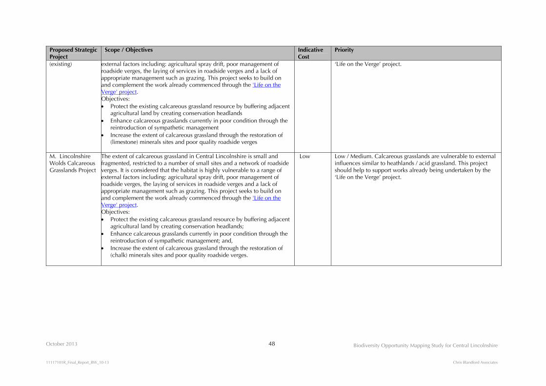
October 2013 48
Biodiversity Opportunity Mapping Study for Central Lincolnshire
11117101R_Final_Report_BW_10-13 Chris Blandford Associates
Proposed Strategic Project
Scope / Objectives Indicative Cost
Priority
(existing) external factors including: agricultural spray drift, poor management of roadside verges, the laying of services in roadside verges and a lack of appropriate management such as grazing. This project seeks to build on and complement the work already commenced through the 'Life on the Verge' project. Objectives:
Protect the existing calcareous grassland resource by buffering adjacent agricultural land by creating conservation headlands
Enhance calcareous grasslands currently in poor condition through the reintroduction of sympathetic management
Increase the extent of calcareous grassland through the restoration of (limestone) minerals sites and poor quality roadside verges
‘Life on the Verge’ project.
M. Lincolnshire Wolds Calcareous Grasslands Project
The extent of calcareous grassland in Central Lincolnshire is small and fragmented, restricted to a number of small sites and a network of roadside verges. It is considered that the habitat is highly vulnerable to a range of external factors including: agricultural spray drift, poor management of roadside verges, the laying of services in roadside verges and a lack of appropriate management such as grazing. This project seeks to build on and complement the work already commenced through the 'Life on the Verge' project. Objectives: Protect the existing calcareous grassland resource by buffering adjacent
agricultural land by creating conservation headlands; Enhance calcareous grasslands currently in poor condition through the
reintroduction of sympathetic management; and, Increase the extent of calcareous grassland through the restoration of
(chalk) minerals sites and poor quality roadside verges.
Low Low / Medium. Calcareous grasslands are vulnerable to external influences similar to heathlands / acid grassland. This project should help to support works already being undertaken by the ‘Life on the Verge’ project.

October 2013 49 Biodiversity Opportunity Mapping Study for Central Lincolnshire
11117101R_Final_Report_BW_10-13 Chris Blandford Associates
4.0 PART 2: BIODIVERSITY OPPORTUNITY MAPPING FOR LINCOLN PRINCIPAL URBAN AREA/SUSTAINABLE URBAN EXTENSIONS/WITHAM VALLEY COUNTRY PARK
4.1 General
4.1.1 The principals for Biodiversity Opportunity Mapping set out in Sections 3.1, 3.216 and 3.3
apply to the Lincoln PUA/SUEs/WVCP scale. The BOAs identified at the Central Lincolnshire
scale are also applied at the Lincoln PUA/SUEs/WVCP scale to provide a broad context and
further refined to identify BOAs at the ‘field scale’, to provide fine grained opportunity
mapping.
4.1.2 The Lincoln PUA/SUEs/WVCP is identified as an opportunity area for a mosaic of habitats.
There is no clearly defined dominant habitat type within this area and, because of the scale of
the mapping, the identification of opportunity priorities can be more refined on a site-by-site or
field scale.
Urban Biodiversity Opportunity Mapping
4.1.3 Biodiversity Opportunity Mapping can sometimes be interpreted as applying to predominantly
rural locations, or the restoration of old industrial sites. However, opportunities also present
themselves within cities such as Lincoln (as well as smaller towns), which can help to make
urban conurbations permeable to wildlife (i.e. greenspace that enables wildlife to disperse and
migrate through urban areas) and provide a suite of ecosystem services that enhances the
quality of life for the people who live there.
4.1.4 The implementation of biodiversity opportunities within urban areas requires an understanding
of localised conditions. For Lincoln, this is characterised by the range of relic habitats which
are the product of the confluence of varied geologies and landscape character types that occur
within the City. The limestone ridge that runs roughly north-south through the centre of the City
broadly influences the habitat characteristics to the east and west of the ridge line. To the east,
on the higher ground, habitats that favour calcareous conditions predominate. To the west and
within the floodplain of the River Witham, low lying land overlaying sand and gravel deposits
tends to favour habitats that prefer wet, neutral and more acidic conditions. Urban biodiversity
opportunities may be considered in two distinct ways:
16 The exception to this is that, as discussed in Section 2.2.11, buffer zones were not applied to open habitats at the Lincoln PUA/SUEs/WVCP scale.
October 2013 50 Biodiversity Opportunity Mapping Study for Central Lincolnshire
11117101R_Final_Report_BW_10-13 Chris Blandford Associates
(i) Retro-fitting biodiversity within the existing urban fabric of the City
4.1.5 Concepts relating to sustainable urban living (urban ‘liveability’), green infrastructure,
ecosystem services embrace the notion of enhancing urban areas to achieve a range of goals
that include:
Improvements to the quality of life experienced by those living in cities; Making cities more permeable for wildlife (i.e. enabling species to migrate and disperse
through urban landscapes); Supporting species of nature conservation concern including, for example, pollinators such
as bees and certain bird species; and, The delivery of ecosystem services such as flood risk management, improving air quality,
management of the ‘heat island’ effect and providing space for access to nature.
4.1.6 The implementation of biodiversity opportunities can achieve these goals through a range of
interventions that include:
New planting, such as street trees, to provide shade and shelter, improve air quality and to
reduce the heat island effect; New planting such as swales and rain gardens, to help manage surface run-off and aid flood
risk management; Planting new parks and gardens to provide access to nature; Enhancing the management of existing greenspaces (e.g. allotments, parks, churchyards) for
the benefit of wildlife; Retrofitting green walls and green roofs on existing built structures, to increase the
buildings’ energy efficiency, reduce storm water run-off, support birds and pollinators and, where feasible, provide access to nature for people; and,
Desealing (the removal of impermeable concrete, tarmac, hardstanding) to enable new planting to provide shade and help the control of storm water run-off by increasing permeability.
(ii) Incorporating biodiversity into new urban extensions and new build
4.1.7 All of the biodiversity opportunities described above, with their associated benefits, can be
incorporated into new build schemes, prior to any works being carried out. The opportunity to
ensure that appropriate natural greenspace (habitats for wildlife) are incorporated into new
scheme layouts is available at the planning stage. This will help to ensure that existing areas of
habitat are not further fragmented as the result of new development, but also ensure that
linkages between these habitats can be strengthened or created. Moreover, the incorporation of
biodiversity opportunities into the fabric of the developments will help to fulfil the broad aims
of sustainable development.
4.1.8 By way of example, the SUE to the east of the City, as with the proposed Lincoln Eastern
Bypass, provide opportunities for the creation and expansion of calcareous grasslands to link
Greetwell Quarry with existing extents of calcareous grassland around Greetwell Hollow,
wetlands (SuDS) with the Lower Witham and woodland planting comprising of limes and ash

October 2013 51 Biodiversity Opportunity Mapping Study for Central Lincolnshire
11117101R_Final_Report_BW_10-13 Chris Blandford Associates
as dominant species, in a variety of locations. Similar opportunities exist for the SUE to the
south of the City. By contrast the SUE around Swanpool would benefit more readily by the
incorporation of wetland habitats focusing around the River Till and Fossdyke Navigation, as
well as grasslands with acidic characteristics further to the west, towards Hartsholme Country
Park and its environs.
4.1.9 Sections 4.2 to 4.5 below describe detailed opportunities for biodiversity protection,
enhancement and creation in the context of broad habitat types. Opportunities for integrating
biodiversity within the urban fabric of Lincoln are signposted within each of the following
Sections. The implementation of such opportunities will require an understanding of very
localised conditions, characterised by the range of relic habitats that occur within Lincoln and
which are the product of the confluence of varied geologies and landscape character types that
occurs within the City.
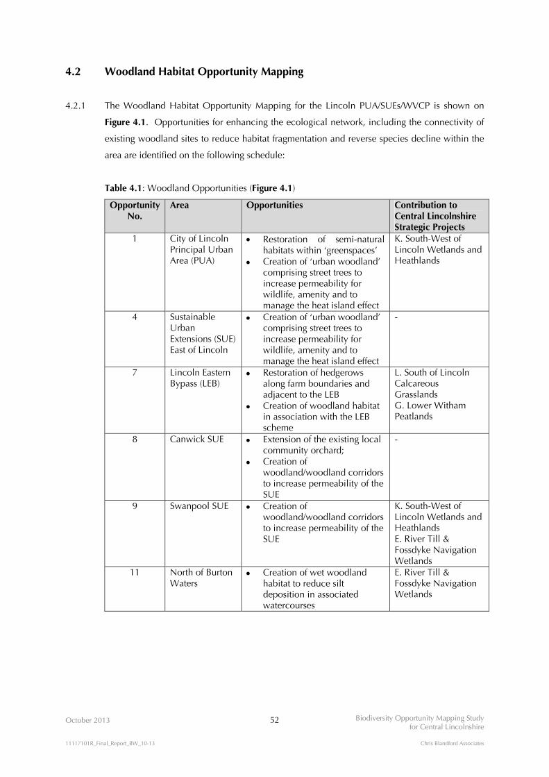
October 2013 52 Biodiversity Opportunity Mapping Study for Central Lincolnshire
11117101R_Final_Report_BW_10-13 Chris Blandford Associates
4.2 Woodland Habitat Opportunity Mapping
4.2.1 The Woodland Habitat Opportunity Mapping for the Lincoln PUA/SUEs/WVCP is shown on
Figure 4.1. Opportunities for enhancing the ecological network, including the connectivity of
existing woodland sites to reduce habitat fragmentation and reverse species decline within the
area are identified on the following schedule:
Table 4.1: Woodland Opportunities (Figure 4.1)
Opportunity No.
Area Opportunities Contribution to Central Lincolnshire Strategic Projects
1 City of Lincoln Principal Urban Area (PUA)
Restoration of semi-natural habitats within ‘greenspaces’
Creation of ‘urban woodland’ comprising street trees to increase permeability for wildlife, amenity and to manage the heat island effect
K. South-West of Lincoln Wetlands and Heathlands
4 Sustainable Urban Extensions (SUE) East of Lincoln
Creation of ‘urban woodland’ comprising street trees to increase permeability for wildlife, amenity and to manage the heat island effect
-
7 Lincoln Eastern Bypass (LEB)
Restoration of hedgerows along farm boundaries and adjacent to the LEB
Creation of woodland habitat in association with the LEB scheme
L. South of Lincoln Calcareous Grasslands G. Lower Witham Peatlands
8 Canwick SUE Extension of the existing local community orchard;
Creation of woodland/woodland corridors to increase permeability of the SUE
-
9 Swanpool SUE Creation of woodland/woodland corridors to increase permeability of the SUE
K. South-West of Lincoln Wetlands and Heathlands E. River Till & Fossdyke Navigation Wetlands
11 North of Burton Waters
Creation of wet woodland habitat to reduce silt deposition in associated watercourses
E. River Till & Fossdyke Navigation Wetlands

!!!!!!!!!!!!!!!!!!!!!!!!!!!!!!!!!!!!!!!!!!!!!!!!!!!!!!!!!!!!!!!!!!!!!!!!!!!!!!!!!!!!!!!!!!!!!!!!!!!!!!!!!!!!!!!!!!!!!!!!!!!!!!!!!!!!!!!!!!!!!!!!!!!!!!!!!!!!!!!!!!!!!!!!!!!!!!!!!!!!!!!!!!!!!!!!!!!!!!!!!!!!!!!!!!!!!!!!!!!!!!!!!!!!!!!!!!!!!!!!!!!!!!!!!!!!!!!!!!!!!!!!!!!!!!!!!!!!!!!!!!!!!!!!!!!!!!!!!!!!!!!!!!!!!!!!!!!!!!!!!!!!!!!!!!!!!!!!!!!!!!!!!!!!!!!!!!!!!!!!!!!!!!!!!!!!!!!!!!!!!!!!!!!!!!!!!!!!!!!!!!!!!!!!!!!!!!!!!!!!!!!!!!!!!!!!!!!!!!!!!!!!!!!!!!!!!!!!!!!!!!!!!!!!!!!!!!!!!!!!!!!!!!!!!!!!!!!!!!!!!!!!!!!!!!!!!!!!!!!!!!!!!!!!!!!!!!!!!!!!!!!!!!
! ! ! ! ! ! ! ! ! !
! ! ! ! ! ! ! ! ! !
! ! ! ! ! ! ! ! ! !
! ! ! ! ! ! ! ! ! !
! ! ! ! ! ! ! ! ! !
! ! ! ! ! ! ! ! ! !
! ! ! ! ! ! ! ! ! !
! ! ! ! ! ! ! ! ! !
! ! ! ! ! ! ! ! !
! ! ! ! ! ! ! ! !
! ! ! ! ! ! ! ! !
! ! ! ! ! ! ! ! !
! ! ! ! ! ! ! ! !
! ! ! ! ! ! ! ! !
! ! ! ! ! ! ! ! !
! ! ! ! ! ! ! ! !
! ! ! ! ! ! ! ! ! !
! ! ! ! ! ! ! ! ! !
! ! ! ! ! ! ! ! ! !
! ! ! ! ! ! ! ! ! !
! ! ! ! ! ! ! ! ! !
! ! ! ! ! ! ! ! ! !
! ! ! ! ! ! ! ! ! !
! ! ! ! ! ! ! ! ! !
! ! ! ! ! ! ! ! ! !
! ! ! ! ! ! ! ! ! !
! ! ! ! ! ! ! ! ! !
! ! ! ! ! ! ! ! ! !
! ! ! ! ! ! !
! ! ! ! ! ! !
! ! ! ! ! ! !
! ! ! ! ! ! !
! ! ! ! ! ! !
! ! ! ! ! ! !
! ! ! ! ! ! ! ! !
! ! ! ! ! ! ! ! !
! ! ! ! ! ! ! ! !
! ! ! ! ! ! ! ! !
! ! ! ! ! ! ! ! !
! ! ! ! ! ! ! ! !
! ! ! !
! ! ! !
! ! ! !
! ! ! !
! ! ! ! ! ! !
! ! ! ! ! ! !
! ! ! ! ! ! !
! ! ! ! ! ! !
! ! ! ! ! ! !
! ! ! ! ! ! !
! ! ! ! ! ! !
! ! ! ! !
! ! ! ! !
! ! ! ! !
! ! ! ! !
! ! ! ! !
! ! ! ! !
! ! ! ! !
! ! ! ! !
! ! ! ! !
! ! ! ! !
! ! ! ! !
! ! ! ! !
! ! !
! ! !
! ! !
! ! !
! ! ! !
! ! ! !
! ! ! !
! ! ! !
! ! ! !
! ! ! !
! !
! !
! ! ! !
! ! ! !
! ! ! !
! ! !
! ! !
! ! !
! ! !
! ! !
! ! !
! ! !
! ! !
! ! !
! ! !
! ! !
! ! !
! !
! !
! !
! !
! !
! !
! !
! ! !
! ! !
! ! !
! ! !
! ! !
! ! !
! ! !
! ! ! !
! ! ! !
! ! ! !
! ! ! !! !
! !
! !
! !
! !
! ! ! ! ! !
! ! ! ! ! !
! ! ! ! ! !
! ! ! ! ! !
! ! ! ! ! !
! ! ! ! ! !
! ! ! ! ! !
! ! ! ! ! !
! ! ! ! ! !
! ! ! ! ! !
! ! ! ! ! !
! ! ! ! !
! ! ! ! !
! ! ! ! !
! ! ! ! !
! ! ! ! !
! ! ! ! !
! ! ! ! !
! ! !
! ! !
! ! !
! ! ! !
! ! ! !
! ! ! !
! ! ! !
! ! !
! ! !
! ! ! ! ! ! ! ! ! ! ! !
! ! ! ! ! ! ! ! ! ! ! !
! ! ! ! ! ! ! ! ! ! ! !
! ! ! ! ! ! ! ! ! ! ! !
! ! ! ! ! ! ! ! ! ! ! !
! ! ! ! ! ! ! ! ! ! ! !
! ! ! ! ! ! ! ! ! ! ! !
! ! ! ! ! ! ! ! ! ! ! !
! !
! !
! !
! ! ! ! !
! ! ! ! !
! ! ! ! !
! ! ! ! !
! ! ! ! !
! ! ! ! !
! ! ! ! !
! ! ! ! !
! ! ! ! !
! ! ! ! !
! ! ! ! !
! ! ! ! !
! ! ! ! !
! ! ! ! !
! ! ! ! !
! ! ! ! !
! ! ! ! !
! ! ! ! !
! ! ! ! !
! ! ! ! !
! ! ! ! !
! ! ! ! !
! ! ! ! !
! ! ! !
! ! ! !
! ! ! !
! ! ! !
! ! ! !
! ! ! !
! ! ! !
! ! ! !
! ! ! !
! ! ! !
! ! ! !
! ! ! !
! ! ! !
! ! ! !
! ! ! ! ! ! ! ! ! ! !
! ! ! ! ! ! ! ! ! ! !
! ! ! ! ! ! ! ! ! ! !
! ! ! ! ! ! ! ! ! ! !
! ! ! ! ! ! ! ! ! ! !
! ! ! ! ! ! ! ! ! ! !
! ! ! ! ! ! ! ! ! ! !
! ! ! ! ! ! ! ! ! ! !
! ! ! ! ! ! ! ! ! ! !
! ! ! ! ! ! ! ! ! ! !
! ! ! ! ! ! ! ! ! ! !
! ! ! ! ! ! ! ! ! ! !
! ! ! ! ! ! ! ! ! ! ! ! ! ! ! ! !
! ! ! ! ! ! ! ! ! ! ! ! ! ! ! ! !
! ! ! ! ! ! ! ! ! ! ! ! ! ! ! ! !
! ! ! ! ! ! ! ! ! ! ! ! ! ! ! ! !
! ! ! ! ! ! ! ! ! ! ! ! ! ! ! ! !
! ! ! ! ! ! ! ! ! ! ! ! ! ! ! ! !
! ! ! ! ! ! ! ! ! ! ! ! ! ! ! ! !
! ! ! ! ! ! ! ! ! ! ! ! ! ! ! ! !
! ! ! ! ! ! ! ! ! ! ! ! ! ! ! ! !
! ! ! ! ! ! ! ! ! ! ! ! ! ! ! ! !
! ! ! ! ! ! ! ! ! ! ! ! ! ! ! ! !
! ! ! ! ! ! ! ! ! ! ! ! ! ! ! ! !
! ! ! ! ! ! ! ! ! ! ! ! ! ! ! ! !
! ! ! ! ! ! ! ! ! ! ! ! ! ! ! ! !
! ! ! ! ! ! ! ! ! ! ! ! ! ! ! ! !
! ! ! ! ! ! ! ! ! ! ! ! ! ! ! ! !
! ! ! ! ! ! ! ! ! ! ! ! ! ! ! ! !
! ! ! ! ! ! ! ! ! ! ! ! ! ! ! ! !
! ! ! ! ! ! ! ! ! ! ! ! ! ! ! ! !
! ! ! ! ! ! ! ! !
! ! ! ! ! ! ! ! !
! ! ! ! ! ! ! ! !
! ! ! ! ! ! ! ! !
! ! ! ! ! ! ! ! !
! ! ! ! ! ! ! ! !
! ! ! ! ! ! ! ! !
! ! ! ! ! ! ! ! !
! ! ! ! ! ! !
! ! ! ! ! ! !
! ! ! ! ! ! !
! ! ! ! ! ! !
! ! ! ! ! ! !
! ! ! ! ! ! !
! !
! !
! ! !
! ! !
! ! !
! ! ! !
! ! ! !
! ! ! !
! ! ! !
! ! ! ! ! ! ! ! ! !
! ! ! ! ! ! ! ! ! !
! ! ! ! ! ! ! ! ! !
! ! ! ! ! ! ! ! ! !
! ! ! ! ! ! ! ! ! !
! ! ! ! ! ! ! ! ! !
! ! ! ! ! ! ! ! ! !
! ! ! ! ! ! ! ! ! !
! ! !
! ! !
!(
!(
!(
!(
!(
!(
!(
!(
!(
!(
!(
!(
!(!(
!(
!(
!(
8
4
7
9
1
39
32
25
26 16
29
14
30
15
17
31
11
OCTOBER 2013
KEY
FIGURE 4.1N
Reproduced by permission of Ordnance Survey on behalf of HMSO. © Crown copyright and database right 2012. All rights reserved. Ordnance Survey Licence number NK100017926
BIODIVERSITY OPPORTUNITY MAPPING STUDYFOR CENTRAL LINCOLNSHIRE
Coniferous plantationwoodland
Woodland (other) 500m ancient woodland bufferSustainable Urban Extensions
Witham Valley CountryPark boundary
Greenspace
Woodland Habitat Opportunity MappingLincoln PUA/SUEs/WVCP
0 1 2 kmAncient woodland
! ! ! ! ! !
! ! ! ! ! !
! ! ! ! ! !
! ! ! ! ! !
Permitted minerals and waste sites
Submitted minerals and waste sites
Targeted opportunity areas for the creation and restoration of a woodland habitat network:
Proposed Lincoln Eastern Bypass Species-poor hedges
30Opportunity Number(see Habitat Opportunity Mapping Schedule - Table 4.5)
This Figure includes relevant dataavailable at the time of the Study,and may not be exhaustive. The digital datasets have been usedin good faith without any modification or enhancement, and their accuracy cannot be guaranteed.
Habitats:
!!!!!!!!!!!!!!!

October 2013 53 Biodiversity Opportunity Mapping Study for Central Lincolnshire
11117101R_Final_Report_BW_10-13 Chris Blandford Associates
Opportunity No.
Area Opportunities Contribution to Central Lincolnshire Strategic Projects
14 Hartsholme Country Park
Restoration of semi-natural habitats through the management and control of Rhododendron
Restoration and enhancement of existing woodland habitat through active management (selective felling; coppicing; ride creation; glade creation)
K. South-West of Lincoln Wetlands and Heathlands
15 Skellingthorpe Moor
Creation of heathland/acid grassland/open woodland /open space
K. South-West of Lincoln Wetlands and Heathlands
16 North of Skellingthorpe
Creation of wet woodland habitat to aid silt reduction and flood risk management
K. South-West of Lincoln Wetlands and Heathlands E. River Till & Fossdyke Navigation Wetlands
17 West of Skellingthorpe
Creation of a woodland habitat corridor linking Ash Lound to Old Wood
K. South-West of Lincoln Wetlands and Heathlands E. River Till & Fossdyke Navigation Wetlands
25 South-east of Doddington
Restoration of broadleaved woodland habitats through suitable management and/or new planting
K. South-West of Lincoln Wetlands and Heathlands
26 West of Skellingthorpe to Thorney
Creation of woodland corridors/stepping stones to link existing habitats of high value
K. South-West of Lincoln Wetlands and Heathlands
29 Minerals sites West of Whisby
Potential for the creation of wet woodland habitat as a component of minerals site restorations, if sites are allocated
K. South-West of Lincoln Wetlands and Heathlands E. River Till & Fossdyke Navigation Wetlands
30 Tunman Wood Creation of wet woodland habitat to aid the control of surface water run-off into adjacent water courses
K. South-West of Lincoln Wetlands and Heathlands
31 River Brant and Washlands
Creation of riparian buffer strips of wet grassland or wet woodland to help improve water quality of the River Brant
Creation of woodland stepping stones to link isolated woodlands
F. River Brant and Upper Witham Wetlands
32 Morton Hall Creation of woodland habitat on prison land to link to Tunman Wood
K. South-West of Lincoln Wetlands and Heathlands
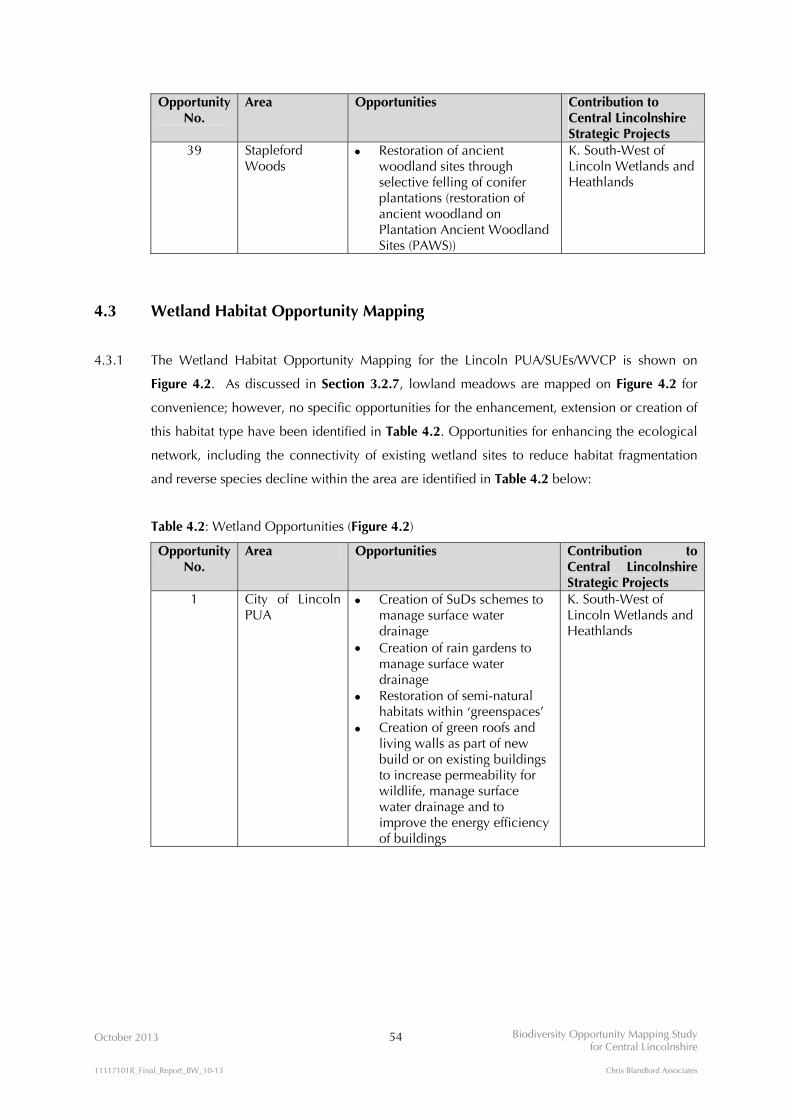
October 2013 54 Biodiversity Opportunity Mapping Study for Central Lincolnshire
11117101R_Final_Report_BW_10-13 Chris Blandford Associates
Opportunity No.
Area Opportunities Contribution to Central Lincolnshire Strategic Projects
39 Stapleford Woods
Restoration of ancient woodland sites through selective felling of conifer plantations (restoration of ancient woodland on Plantation Ancient Woodland Sites (PAWS))
K. South-West of Lincoln Wetlands and Heathlands
4.3 Wetland Habitat Opportunity Mapping
4.3.1 The Wetland Habitat Opportunity Mapping for the Lincoln PUA/SUEs/WVCP is shown on
Figure 4.2. As discussed in Section 3.2.7, lowland meadows are mapped on Figure 4.2 for
convenience; however, no specific opportunities for the enhancement, extension or creation of
this habitat type have been identified in Table 4.2. Opportunities for enhancing the ecological
network, including the connectivity of existing wetland sites to reduce habitat fragmentation
and reverse species decline within the area are identified in Table 4.2 below:
Table 4.2: Wetland Opportunities (Figure 4.2)
Opportunity No.
Area Opportunities Contribution to Central Lincolnshire Strategic Projects
1 City of Lincoln PUA
Creation of SuDs schemes to manage surface water drainage
Creation of rain gardens to manage surface water drainage
Restoration of semi-natural habitats within ‘greenspaces’
Creation of green roofs and living walls as part of new build or on existing buildings to increase permeability for wildlife, manage surface water drainage and to improve the energy efficiency of buildings
K. South-West of Lincoln Wetlands and Heathlands

!!!!!!!!!!!!!!!!!!!!!!!!!!!!!!!!!!!!!!!!!!!!!!!!!!!!!!!!!!!!!!!!!!!!!!!!!!!!!!!!!!!!!!!!!!!!!!!!!!!!!!!!!!!!!!!!!!!!!!!!!!!!!!!!!!!!!!!!!!!!!!!!!!!!!!!!!!!!!!!!!!!!!!!!!!!!!!!!!!!!!!!!!!!!!!!!!!!!!!!!!!!!!!!!!!!!!!!!!!!!!!!!!!!!!!!!!!!!!!!!!!!!!!!!!!!!!!!!!!!!!!!!!!!!!!!!!!!!!!!!!!!!!!!!!!!!!!!!!!!!!!!!!!!!!!!!!!!!!!!!!!!!!!!!!!!!!!!!!!!!!!!!!!!!!!!!!!!!!!!!!!!!!!!!!!!!!!!!!!!!!!!!!!!!!!!!!!!!!!!!!!!!!!!!!!!!!!!!!!!!!!!!!!!!!!!!!!!!!!!!!!!!!!!!!!!!!!!!!!!!!!!!!!!!!!!!!!!!!!!!!!!!!!!!!!!!!!!!!!!!!!!!!!!!!!!!!!!!!!!!!!!!!!!!!!!!!!!!!!!!!!!!!!
p
!(
!(!(
!(!(
!(!(
!(
!(
!(
!(
!(
!(
!(
!(
!(
!(
!(
!(
!(
!(
!(
8
4
7
9
6
5
1
40
16
29
10
24
14
30
28
31
37
11
19 13
22
21
OCTOBER 2013
KEY
0 1 2 km
FIGURE 4.2Wetland Habitat Opportunity MappingLincoln PUA/SUEs/WVCP
N
Reproduced by permission of Ordnance Survey on behalf of HMSO. © Crown copyright and database right 2012. All rights reserved. Ordnance Survey Licence number NK100017926
BIODIVERSITY OPPORTUNITY MAPPING STUDYFOR CENTRAL LINCOLNSHIRE
Witham Valley CountryPark boundary
Wetlands
Ecological Statusof Rivers:
Good
Moderate
Bad
Submitted mineralsand waste sites
p MOD Airbase(constraint)
Sustainable Urban Extensions Permitted minerals
and waste sitesThe Brant and Till Washlands
Neutral grassland
Wetland Biodiversity Opportunity Areas
Targeted opportunity areas for the creation and restoration of a wetland habitat network:
Proposed Lincoln Eastern Bypass
30 Opportunity Number(see Habitat OpportunityMapping Schedule - Table 4.5)
This Figure includes relevant dataavailable at the time of the Study,and may not be exhaustive. The digital datasets have been usedin good faith without any modification or enhancement, and their accuracy cannot be guaranteed.
Habitats:Opportunity Areas:
!!!!!!!!!!!!!!!

October 2013 55 Biodiversity Opportunity Mapping Study for Central Lincolnshire
11117101R_Final_Report_BW_10-13 Chris Blandford Associates
Opportunity No.
Area Opportunities Contribution to Central Lincolnshire Strategic Projects
4 SUE East of Lincoln
Creation of SuDs schemes to manage surface water drainage
Creation of green roofs and living walls as part of new build or on existing buildings to increase permeability for wildlife, manage surface water drainage and to improve the energy efficiency of buildings
G. Lower Witham Peatlands
5 Sincil Dyke Restoration of the dyke through ‘decanalisation’, in-channel and riparian enhancements
Re-establishment of marginal and in-channel vegetation cover
Planting occasional tree and shrub cover
Creation of backwaters and bays for still-water habitat and high-flow refuge
G. Lower Witham Peatlands
6 North of Canwick
Creation of wetland habitat/wet grazing meadow for SE growth area
G. Lower Witham Peatlands
7 Lincoln Eastern Bypass
Creation of SuDs schemes to provide ‘naturalised’ open water habitats
G. Lower Witham Peatlands
8 Canwick SUE Creation of SuDs schemes to manage surface water drainage
Creation of wetland habitat/wet grazing marsh to increase the extent of the existing resource and to aid flood risk management
Creation of green roofs and living walls as part of new build or on existing buildings to increase permeability for wildlife, manage surface water drainage and to improve the energy efficiency of buildings
G. Lower Witham Peatlands

October 2013 56 Biodiversity Opportunity Mapping Study for Central Lincolnshire
11117101R_Final_Report_BW_10-13 Chris Blandford Associates
Opportunity No.
Area Opportunities Contribution to Central Lincolnshire Strategic Projects
9 Swanpool SUE Creation of new, or extensions to, existing reedbeds
Creation of SuDs schemes to manage surface water drainage
Creation of new ‘greenspace’ comprising a mosaic of wetland, heathland and acid grassland habitats
Creation of a blue corridor between Hartsholme Lake and Ballast Holes to increase the permeability of the SUE for wildlife and to aid flood risk management
Creation of green roofs and living walls as part of new build or on existing buildings to increase permeability for wildlife, manage surface water drainage and to improve the energy efficiency of buildings
E. River Till & Fossdyke Navigation Wetlands
10 Fossdyke Navigation
Restoration of ‘naturalised’ channel characteristics through the removal of in-channel obstructions
Restoration of habitat suitable for water voles / eels
Re-establishment of marginal and in-channel vegetation cover
Channel narrowing to improve the flow regime
Planting occasional tree and shrub cover
Creation of backwaters and bays for still-water habitat and high-flow refuge
E. River Till & Fossdyke Navigation Wetlands
11 North of Burton Waters
Creation of a wet grassland and reedbed habitat mosaic to aid flood risk management
Creation of wet woodland habitat to reduce silt deposition in associated watercourses
E. River Till & Fossdyke Navigation Wetlands

October 2013 57 Biodiversity Opportunity Mapping Study for Central Lincolnshire
11117101R_Final_Report_BW_10-13 Chris Blandford Associates
Opportunity No.
Area Opportunities Contribution to Central Lincolnshire Strategic Projects
13 Pike Drain Creation of eel passes to aid migration
Re-establishment of marginal and in-channel vegetation cover
Channel narrowing to improve the flow regime
Creation of backwaters and bays for still-water habitat and high-flow refuge
Planting of occasional tree and shrub cover
F. River Brant and Upper Witham Wetlands
14 Hartsholme Country Park & Swanholme Lakes LNR
Restoration of the small area of remnant bog through suitable management - only location of this habitat in the city
Restoration of remnant open wetland habitats through the selective clearance of woodland
Creation of open water habitats within the woodland area to avoid the need for increasing size of the outfall from Hartsholme Lake
E. River Till & Fossdyke Navigation Wetlands
16 North of Skellingthorpe
Creation of wet woodland habitat to aid silt reduction and flood risk management
E. River Till & Fossdyke Navigation Wetlands
19 Prial Drain Restoration of the drain through ‘decanalisation’, in-channel and riparian enhancements
Re-establishment of marginal and in-channel vegetation cover
Channel narrowing to improve the flow regime
Creation of backwaters and bays for still-water habitat and high-flow refuge
E. River Till & Fossdyke Navigation Wetlands

October 2013 58 Biodiversity Opportunity Mapping Study for Central Lincolnshire
11117101R_Final_Report_BW_10-13 Chris Blandford Associates
Opportunity No.
Area Opportunities Contribution to Central Lincolnshire Strategic Projects
21 East of North Hykeham
Creation of new reedbeds to help improve water quality of the River Brant and its tributaries
Creation of wetland habitats / wet meadows to aid flood risk management
Restoration of neutral grassland habitat on the river banks
Restoration of semi-natural habitats through targeting of environmental land management schemes
Restoration of wet grassland / floodplain habitats through suitable management
F. River Brant and Upper Witham Wetlands
22 North-west of Waddington
Creation of wetland habitats/wet meadows to aid flood risk management
Re-establishment of marginal and in-channel vegetation cover
Channel narrowing to improve the flow regime
Creation of a multi-stage channel with a low-flow sediment berm
Creation of backwaters and bays for still-water habitat and high-flow refuge
F. River Brant and Upper Witham Wetlands
24 Minerals sites East of Whisby
Potential restoration to a mosaic of open waterbody and wetland habitat types, dependent upon submitted sites receiving approval
K. South-West of Lincoln Wetlands and Heathlands
28 Lincoln Edge/Cliff (including the Viking Way)
Protection of important spring-fed habitats/calcareous flushes, if identified as being present
F. River Brant and Upper Witham Wetlands L. South of Lincoln Calcareous Grasslands
29 Minerals sites West of Whisby
Potential creation of new reedbeds as a component of minerals site restorations, if sites are allocated
Potential creation of wet woodland habitat as a component of minerals site restorations, if sites are allocated
K. South-West of Lincoln Wetlands and Heathlands
30 Tunman Wood Creation of wet woodland habitat to aid the control of surface water run-off into adjacent water courses
K. South-West of Lincoln Wetlands and Heathlands

October 2013 59 Biodiversity Opportunity Mapping Study for Central Lincolnshire
11117101R_Final_Report_BW_10-13 Chris Blandford Associates
Opportunity No.
Area Opportunities Contribution to Central Lincolnshire Strategic Projects
31 River Brant and Washlands
Creation of riparian buffer strips of wet grassland or wet woodland to help improve water quality of the River Brant
Restoration of ‘naturalised’ channel characteristics through the removal of in-channel obstructions;
Maintenance, enhancement and expansion of current wetland site at Blackmoor Bridge
Assess requirements for de-silting, and undertake if considered necessary
Creation of in-channel features such as riffle-pool sequences and in-channel deflectors to enhance flow characteristics
Restoration of pasture through arable reversion within washland, where feasible
F. River Brant and Upper Witham Wetlands
37 North of Brant Broughton
Creation of a new washland - preferably grassland/pasture, rather than arable to aid flood risk management
Re-establishment of marginal and in-channel vegetation cover
Channel narrowing to improve the flow regime
Creation of a multi-stage channel with a low-flow sediment berm
Creation of backwaters and bays for still-water habitat and high-flow refuge
F. River Brant and Upper Witham Wetlands

October 2013 60 Biodiversity Opportunity Mapping Study for Central Lincolnshire
11117101R_Final_Report_BW_10-13 Chris Blandford Associates
Opportunity No.
Area Opportunities Contribution to Central Lincolnshire Strategic Projects
40 Beckingham and downstream towards Lincoln
Restoration of semi-natural habitats at Beckingham Ranges through suitable management
Re-establishment of marginal and in-channel vegetation cover
Channel narrowing to improve the flow regime
Creation of a multi-stage channel with a low-flow sediment berm
Creation of backwaters and bays for still-water habitat and high-flow refuge
Creation of bank-side and in-channel woody material
Planting occasional tree and shrub cover
Creation of channel-floodplain habitat connectivity
F. River Brant and Upper Witham Wetlands
4.4 Heathland & Acid Grassland Habitat Opportunity Mapping
4.4.1 The Heathland & Acid Grassland Habitat Opportunity Mapping for the Lincoln
PUA/SUEs/WVCP is shown on Figure 4.3. As discussed in Section 3.2.7, dry neutral
grasslands, such as lowland meadows, are mapped on Figure 4.2 for convenience; however,
opportunities for the extension or creation of this habitat type have been identified in Table 4.3,
where these opportunities are considered appropriate. Opportunities for enhancing the
ecological network, including the connectivity of existing heathland/acid grassland sites to
reduce habitat fragmentation and reverse species decline within the area are identified in Table
4.3 below:
Table 4.3: Heathland / Acid Grassland Opportunities (Figure 4.3)
Opportunity No.
Area Opportunities Contribution to Central Lincolnshire Strategic Projects
1 City of Lincoln PUA
Restoration of acid grassland habitats within greenspaces’
K. South-West of Lincoln Wetlands and Heathlands
8 Canwick SUE Creation of a grassland buffer around the neutral grassland on South Common
K. South-West of Lincoln Wetlands and Heathlands

############################
######
##############################
###################################
###### ###
######
########################################
############
#########
######
######
####
########## ###
######
################
###############
############
######
####
############
#########
#########
######
#############################################################################################################################################################################################################################
#########
################################################
#########
##########################################
####################
####################################
############
########
############
#########
######################################################################
######
########
#####################
######
############
########
############
#########################
######
############
####
#########
##########
#########################
######
################
################################
#########
#########
######
########################
#########
#########
#############################################################################
############
################
#########
#########
################
############
############
######
#########
####################
#########
########################################################
############################
############
######
####################
####
############
########
######
####
############
###############
######
############
#########
######
######
########
####
############
######
#########
#########
######
######
#########
######
######
########
################
####
############
############
######
####
#########
##################
######
####################################
##########################################################################################################################################################################################################################################
###############################################################
##########################################
!(
!(
!(
!(
!(
!(
!(
!(
!(
!(!(
!( !(
!(
!(
!(
!(
!(
8
91
35
25
33
29
10
2024
18 12
14
30
36
15
27
34
OCTOBER 2013
KEY
0 1 2 km
FIGURE 4.3N
Reproduced by permission of Ordnance Survey on behalf of HMSO. © Crown copyright and database right 2012. All rights reserved. Ordnance Survey Licence number NK100017926
BIODIVERSITY OPPORTUNITY MAPPING STUDY FOR CENTRAL LINCOLNSHIRE
Witham Valley CountryPark boundary Sites including
heathlandSustainable UrbanExtensions Coniferous (non-ancient)
plantation woodland
Permitted sand and gravel extraction sites
Heathland & Acid Grassland Habitat Opportunity MappingLincoln PUA/SUEs/WVCP
Soil most likely suitable for heathland and acid grassland habitat creation
Acid grassland Greenspace########################
Targeted opportunity areas for the creation and restoration of a heathland/acid grassland habitat network:
Submitted sand and gravel extraction sites
30 Opportunity Number(see Habitat Opportunity Mapping Schedule - Table 4.5)
This Figure includes relevant dataavailable at the time of the Study,and may not be exhaustive. The digital datasets have been usedin good faith without any modification or enhancement, and their accuracy cannot be guaranteed.
Habitats:
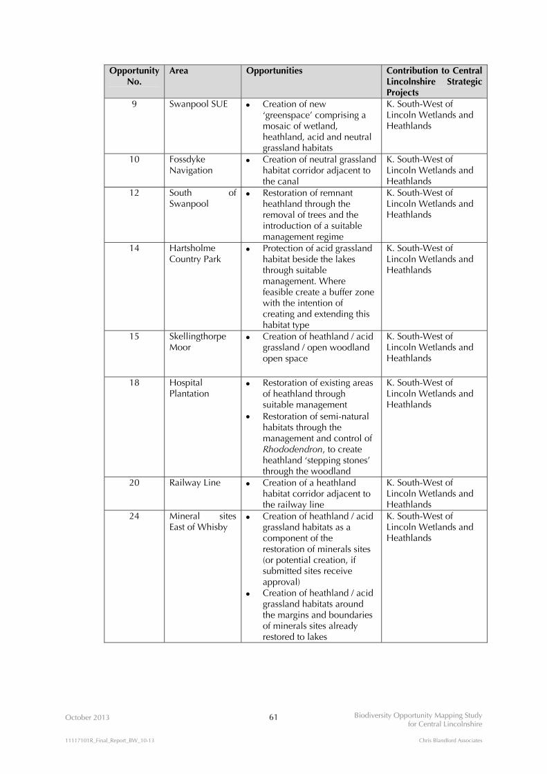
October 2013 61 Biodiversity Opportunity Mapping Study for Central Lincolnshire
11117101R_Final_Report_BW_10-13 Chris Blandford Associates
Opportunity No.
Area Opportunities Contribution to Central Lincolnshire Strategic Projects
9 Swanpool SUE Creation of new ‘greenspace’ comprising a mosaic of wetland, heathland, acid and neutral grassland habitats
K. South-West of Lincoln Wetlands and Heathlands
10 Fossdyke Navigation
Creation of neutral grassland habitat corridor adjacent to the canal
K. South-West of Lincoln Wetlands and Heathlands
12 South of Swanpool
Restoration of remnant heathland through the removal of trees and the introduction of a suitable management regime
K. South-West of Lincoln Wetlands and Heathlands
14 Hartsholme Country Park
Protection of acid grassland habitat beside the lakes through suitable management. Where feasible create a buffer zone with the intention of creating and extending this habitat type
K. South-West of Lincoln Wetlands and Heathlands
15 Skellingthorpe Moor
Creation of heathland / acid grassland / open woodland open space
K. South-West of Lincoln Wetlands and Heathlands
18 Hospital Plantation
Restoration of existing areas of heathland through suitable management
Restoration of semi-natural habitats through the management and control of Rhododendron, to create heathland ‘stepping stones’ through the woodland
K. South-West of Lincoln Wetlands and Heathlands
20 Railway Line Creation of a heathland habitat corridor adjacent to the railway line
K. South-West of Lincoln Wetlands and Heathlands
24 Mineral sites East of Whisby
Creation of heathland / acid grassland habitats as a component of the restoration of minerals sites (or potential creation, if submitted sites receive approval)
Creation of heathland / acid grassland habitats around the margins and boundaries of minerals sites already restored to lakes
K. South-West of Lincoln Wetlands and Heathlands
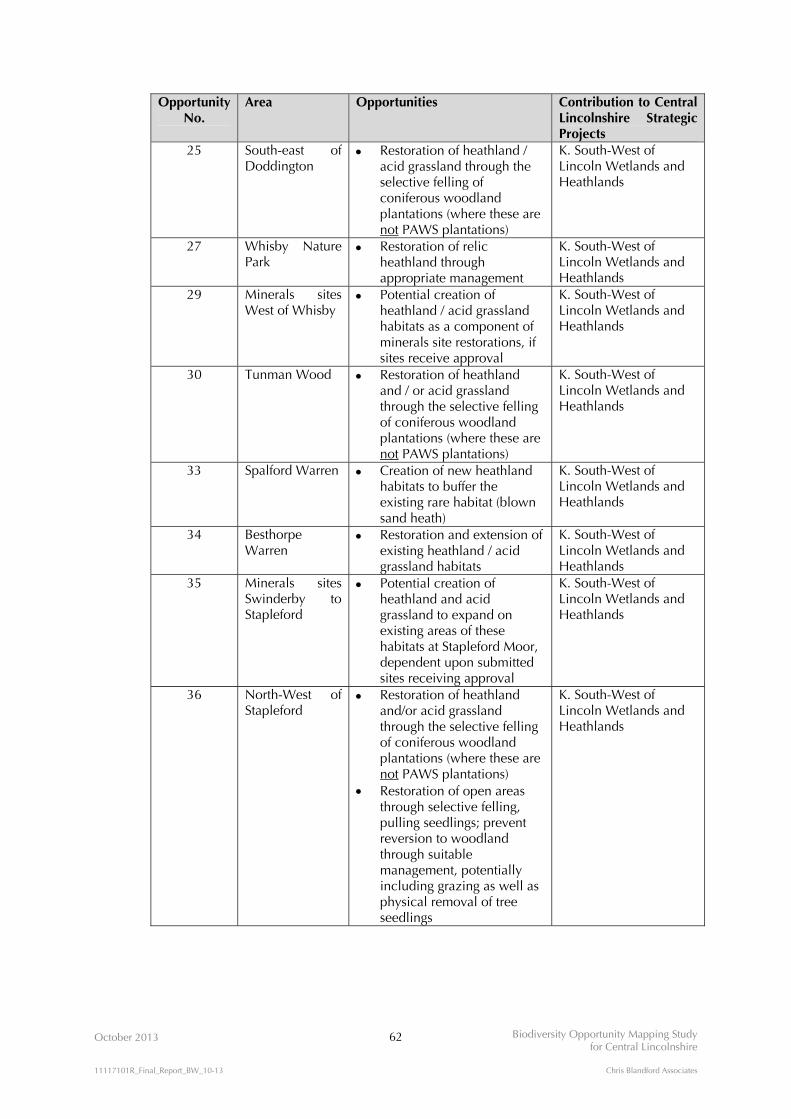
October 2013 62 Biodiversity Opportunity Mapping Study for Central Lincolnshire
11117101R_Final_Report_BW_10-13 Chris Blandford Associates
Opportunity No.
Area Opportunities Contribution to Central Lincolnshire Strategic Projects
25 South-east of Doddington
Restoration of heathland / acid grassland through the selective felling of coniferous woodland plantations (where these are not PAWS plantations)
K. South-West of Lincoln Wetlands and Heathlands
27 Whisby Nature Park
Restoration of relic heathland through appropriate management
K. South-West of Lincoln Wetlands and Heathlands
29 Minerals sites West of Whisby
Potential creation of heathland / acid grassland habitats as a component of minerals site restorations, if sites receive approval
K. South-West of Lincoln Wetlands and Heathlands
30 Tunman Wood Restoration of heathland and / or acid grassland through the selective felling of coniferous woodland plantations (where these are not PAWS plantations)
K. South-West of Lincoln Wetlands and Heathlands
33 Spalford Warren Creation of new heathland habitats to buffer the existing rare habitat (blown sand heath)
K. South-West of Lincoln Wetlands and Heathlands
34 Besthorpe Warren
Restoration and extension of existing heathland / acid grassland habitats
K. South-West of Lincoln Wetlands and Heathlands
35 Minerals sites Swinderby to Stapleford
Potential creation of heathland and acid grassland to expand on existing areas of these habitats at Stapleford Moor, dependent upon submitted sites receiving approval
K. South-West of Lincoln Wetlands and Heathlands
36 North-West of Stapleford
Restoration of heathland and/or acid grassland through the selective felling of coniferous woodland plantations (where these are not PAWS plantations)
Restoration of open areas through selective felling, pulling seedlings; prevent reversion to woodland through suitable management, potentially including grazing as well as physical removal of tree seedlings
K. South-West of Lincoln Wetlands and Heathlands
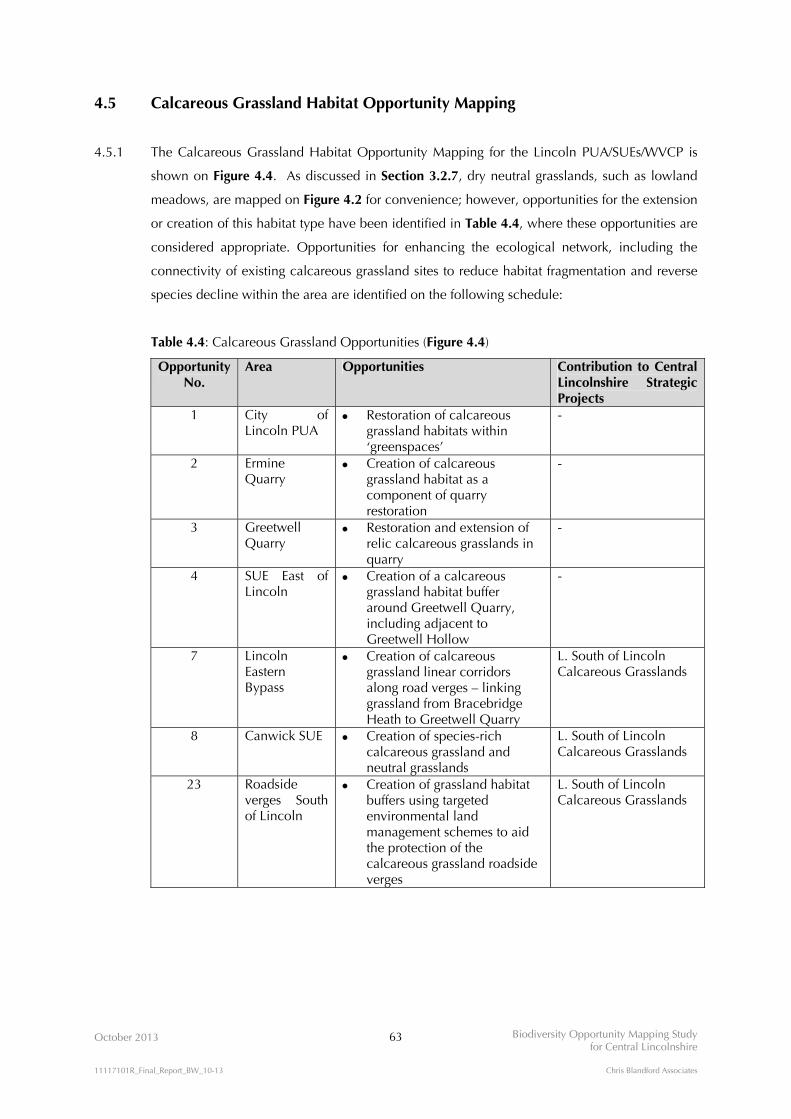
October 2013 63 Biodiversity Opportunity Mapping Study for Central Lincolnshire
11117101R_Final_Report_BW_10-13 Chris Blandford Associates
4.5 Calcareous Grassland Habitat Opportunity Mapping
4.5.1 The Calcareous Grassland Habitat Opportunity Mapping for the Lincoln PUA/SUEs/WVCP is
shown on Figure 4.4. As discussed in Section 3.2.7, dry neutral grasslands, such as lowland
meadows, are mapped on Figure 4.2 for convenience; however, opportunities for the extension
or creation of this habitat type have been identified in Table 4.4, where these opportunities are
considered appropriate. Opportunities for enhancing the ecological network, including the
connectivity of existing calcareous grassland sites to reduce habitat fragmentation and reverse
species decline within the area are identified on the following schedule:
Table 4.4: Calcareous Grassland Opportunities (Figure 4.4)
Opportunity No.
Area Opportunities Contribution to Central Lincolnshire Strategic Projects
1 City of Lincoln PUA
Restoration of calcareous grassland habitats within ‘greenspaces’
-
2 Ermine Quarry
Creation of calcareous grassland habitat as a component of quarry restoration
-
3 Greetwell Quarry
Restoration and extension of relic calcareous grasslands in quarry
-
4 SUE East of Lincoln
Creation of a calcareous grassland habitat buffer around Greetwell Quarry, including adjacent to Greetwell Hollow
-
7 Lincoln Eastern Bypass
Creation of calcareous grassland linear corridors along road verges – linking grassland from Bracebridge Heath to Greetwell Quarry
L. South of Lincoln Calcareous Grasslands
8 Canwick SUE Creation of species-rich calcareous grassland and neutral grasslands
L. South of Lincoln Calcareous Grasslands
23 Roadside verges South of Lincoln
Creation of grassland habitat buffers using targeted environmental land management schemes to aid the protection of the calcareous grassland roadside verges
L. South of Lincoln Calcareous Grasslands

!!!!!!!!!!!!!!!!!!!!!!!!!!!!!!!!!!!!!!!!!!!!!!!!!!!!!!!!!!!!!!!!!!!!!!!!!!!!!!!!!!!!!!!!!!!!!!!!!!!!!!!!!!!!!!!!!!!!!!!!!!!!!!!!!!!!!!!!!!!!!!!!!!!!!!!!!!!!!!!!!!!!!!!!!!!!!!!!!!!!!!!!!!!!!!!!!!!!!!!!!!!!!!!!!!!!!!!!!!!!!!!!!!!!!!!!!!!!!!!!!!!!!!!!!!!!!!!!!!!!!!!!!!!!!!!!!!!!!!!!!!!!!!!!!!!!!!!!!!!!!!!!!!!!!!!!!!!!!!!!!!!!!!!!!!!!!!!!!!!!!!!!!!!!!!!!!!!!!!!!!!!!!!!!!!!!!!!!!!!!!!!!!!!!!!!!!!!!!!!!!!!!!!!!!!!!!!!!!!!!!!!!!!!!!!!!!!!!!!!!!!!!!!!!!!!!!!!!!!!!!!!!!!!!!!!!!!!!!!!!!!!!!!!!!!!!!!!!!!!!!!!!!!!!!!!!!!!!!!!!!!!!!!!!!!!!!!!!!!!!!!!!!!
!(
!(
!(
!(
!(!(
!(
!(
!(
2
8
4
3
7
1
23
38
28
OCTOBER 2013
KEY
FIGURE 4.4N
Reproduced by permission of Ordnance Survey on behalf of HMSO. © Crown copyright and database right 2012. All rights reserved. Ordnance Survey Licence number NK100017926
BIODIVERSITY OPPORTUNITY MAPPING STUDYFOR CENTRAL LINCOLNSHIRE
Witham Valley Country Park boundary
Sustainable Urban Extensions Greenspace
0 1 2 km
Calcareous Grassland Habitat Opportunity MappingLincoln PUA/SUEs/WVCP
Permitted limestone extraction site
Soil most likely suitable for calcareous grassland habitat creation
Calcareous grassland Proposed Lincoln Eastern Bypass!!!!!!!!!!!!!!!
Targeted opportunity areas for the creation and restoration of a calcareous grassland habitat network:
Submitted mineral extraction site - building stone
28Opportunity Number(see Habitat Opportunity Mapping Schedule - Table 4.5)
This Figure includes relevant dataavailable at the time of the Study,and may not be exhaustive. The digital datasets have been usedin good faith without any modification or enhancement, and their accuracy cannot be guaranteed.
Habitats:

October 2013 64 Biodiversity Opportunity Mapping Study for Central Lincolnshire
11117101R_Final_Report_BW_10-13 Chris Blandford Associates
Opportunity No.
Area Opportunities Contribution to Central Lincolnshire Strategic Projects
28 Lincoln Edge/Cliff (including the Viking Way)
Protection and restoration important spring-fed habitats / calcareous flushes
Restoration of grassland habitats (including calcareous) and corridors through favourable management using agri-environment funding
L. South of Lincoln Calcareous Grasslands
38 South of Harmston Heath to Webourn Heath
Restoration of road verges through suitable management e.g. cutting and baling, removing scrub
L. South of Lincoln Calcareous Grasslands

October 2013 65 Biodiversity Opportunity Mapping Study for Central Lincolnshire
11117101R_Final_Report_BW_10-13 Chris Blandford Associates
4.6 Biodiversity Opportunity Mapping Schedule
4.6.1 The Biodiversity Opportunity Mapping Schedule for the Lincoln PUA/SUEs/WVCP (Table 4.5)
below combines all of the opportunities described above in Sections 4.1- 4.4, listing them by
geographical location and ranking them in terms of their priority for delivery.

V
I
IV
II
III
2
8
4
3
7
9
6
5
1
39
35
23
32
25
26
40
16
33
29
10
2024
18 12
14
30
36
15
17
27
38
34
28
31
37
11
19 13
22
21
OCTOBER 2013
KEY
0 2 4 km
Reproduced by permission of Ordnance Survey on behalf of HMSO. © Crown copyright and database right 2012. All rights reserved. Ordnance Survey Licence number NK100017926
BIODIVERSITY OPPORTUNITY MAPPING STUDYFOR CENTRAL LINCOLNSHIRE
This Figure includes relevant dataavailable at the time of the Study,and may not be exhaustive. The digital datasets have been usedin good faith without any modification or enhancement, and their accuracy cannot be guaranteed.
The BOAs represent the priority areasof opportunity within Central Lincolnshire for the restoration and creation of Biodiversity Action Plan (BAP) and otherhabitats. They are intended to be a spatial representation of the Lincolnshire BAP'shabitat targets and are areas of opportunity, not constraint. The BOAs shown in the mapdo not necessarily include all BAP habitatin Central Lincolnshire, nor do they includeall the areas where habitat could exist.
Witham Valley Country Park Boundary
Sustainable Urban Extensions
Targeted opportunity areas for habitat creation and restoration (see Section 4.6):
Lincoln Calcareous Grasslands Lincoln Heathland
South-West Lincoln Mosaic
Upper Witham and Brant Wetlands
IIIIII
IVTill and Fossdyke WetlandsV
Woodland Heathland
Wetland Calcareous Grassland
39
40
38
36
FIGURE 4.5N
Biodiversity Opportunity Map for Lincoln PUA/SUEs/WVCP
Habitats:
(See Figs 4.1 - 4.4)
Biodiversity Opportunity Areas:

October 2013 66 Biodiversity Opportunity Mapping Study for Central Lincolnshire
11117101R_Final_Report_BW_10-13 Chris Blandford Associates
Table 4.5. Biodiversity Opportunity Mapping Schedule for the Lincoln PUA/SUEs/WVCP
Opportunity No.
BOA Figure No.
Area Opportunities for Enhancing the Ecological Habitat Network Sensitivity
1 - 4.1 4.2 4.3 4.4
City of Lincoln Principal Urban Area (PUA)
Creation of SuDs schemes to manage surface water drainage Creation of rain gardens to manage surface water drainage Restoration of acid grassland habitats within ‘greenspaces’ Restoration of calcareous grasslands within ‘greenspaces’
High
Restoration of semi-natural habitats within ‘greenspaces’
Creation of ‘urban woodland’ comprising street trees to increase permeability for wildlife, amenity and to manage the heat
island effect Creation of green roofs and living walls as part of new build or on existing buildings to increase permeability for wildlife,
manage surface water drainage and to improve the energy efficiency of buildings
Medium
Restoration of cemeteries and allotments to benefit wildlife through sympathetic management Low
2 I 4.4 Ermine Quarry Creation of calcareous grassland habitat as a component of quarry restoration High
3 I 4.4 Greetwell Hollow Quarry Restoration and extension of relic calcareous grasslands in quarry High
4 I 4.1 4.2 4.4
Sustainable Urban Extension (SUE) East of Lincoln
Creation of a calcareous grassland habitat buffer around Greetwell Quarry including adjacent to Greetwell Hollow
Creation of SuDs schemes to manage surface water drainage
High
Creation of ‘urban woodland’ comprising street trees to increase permeability for wildlife, amenity and to manage the heat
island effect
Creation of green roofs and living walls as part of new build or on existing buildings to increase permeability for wildlife, manage surface water drainage and to improve the energy efficiency of buildings
Medium
Creation of ‘urban woodland’ comprising street trees to increase permeability for wildlife, amenity and to manage the heat island effect
Low
5 - 4.2 Sincil Dyke Restoration of the dyke through ‘decanalisation’, in-channel and riparian enhancements High
Re-establishment of marginal and in-channel vegetation cover
Planting occasional tree and shrub cover
Creation of backwaters and bays for still-water habitat and high-flow refuge 6 - 4.2 North of Canwick Creation of wetland habitat/wet grazing meadow for SE growth area High
7 I 4.1 4.2 4.4
Lincoln Eastern Bypass (LEB)
Creation of calcareous grassland linear corridors along road verges – linking grassland from Bracebridge Heath to
Greetwell Quarry
Creation of SuDs schemes to provide ‘naturalised’ open water habitats
High
Restoration of hedgerows along farm boundaries and adjacent to the LEB Medium
Creation of woodland habitat in association with the LEB scheme Low
8 I 4.1 4.2 4.3 4.4
Canwick SUE Creation of species-rich calcareous and neutral grasslands
Creation of a grassland buffer around the acid/neutral grassland on South Common
Creation of SuDs schemes to manage surface water drainage
High
Creation of wetland habitat/wet grazing meadow to increase the extent of the existing resource and to aid flood risk management
Medium
Extension of the existing local community orchard
Creation of woodland/woodland corridors to increase permeability of the SUE
Creation of green roofs and living walls as part of new build or on existing buildings to increase permeability for wildlife, manage surface water drainage and to improve the energy efficiency of buildings
Low
9 V 4.1 4.2 4.3
Swanpool SUE Creation of new, or extensions to existing reedbeds
Creation of SuDs schemes to manage surface water drainage
Creation of new ‘greenspace’ comprising a mosaic of wetland, heathland and acid grassland habitats
Creation of a blue corridor between Hartsholme Lake and Ballast Holes to increase the permeability of the SUE for wildlife and to aid flood risk management
High

October 2013 67 Biodiversity Opportunity Mapping Study for Central Lincolnshire
11117101R_Final_Report_BW_10-13 Chris Blandford Associates
Opportunity No.
BOA Figure No.
Area Opportunities for Enhancing the Ecological Habitat Network Sensitivity
Creation of green roofs and living walls as part of new build or on existing buildings to increase permeability for wildlife,
manage surface water drainage and to improve the energy efficiency of buildings
Medium
Creation of woodland/woodland corridors to increase permeability of the SUE Low
10 V 4.2 4.3
Fossdyke Navigation Restoration of ‘naturalised’ channel characteristics through the removal of in-channel obstructions
Restoration of habitat suitable for water voles/eels
Re-establishment of marginal and in-channel vegetation cover
Channel narrowing to improve the flow regime
Planting occasional tree and shrub cover
Creation of backwaters and bays for still-water habitat and high-flow refuge
Creation of neutral grassland habitat corridor adjacent to the canal
High
Creation of a heathland/acid grassland habitat corridor adjacent to the canal Low
11 V 4.1 4.2
North of Burton Waters Creation of a wet grassland and reedbed habitat mosaic to aid flood risk management High
Creation of wet woodland habitat to reduce silt deposition in associated watercourses Low
12 III 4.3 South of Swanpool Restoration of remnant heathland through the removal of trees and the introduction of a suitable management regime High
13 III 4.2 Pike Drain Creation of eel passes to aid migration
Re-establishment of marginal and in-channel vegetation cover
Channel narrowing to improve the flow regime
Planting occasional tree and shrub cover
Creation of backwaters and bays for still-water habitat and high-flow refuge
High
14 III 4.1 4.2 4.3
Hartsholme Country Park Restoration of the small area of remnant bog through suitable management - only location of this habitat in the city
Protection of acid grassland habitat beside the lakes through suitable management. Where feasible create a buffer zone with the intention of creating and extending this habitat type
Restoration of remnant open wetland habitats through the selective clearance of woodland
High
Restoration of semi-natural habitats through the management and control of Rhododendron
Creation of open water habitats within the woodland area to avoid the need for increasing size of the outfall from Hartsholme Lake
Medium
Restoration and enhancement of existing woodland habitat through active management (selective felling; coppicing; ride creation; glade creation)
Low
15 IV 4.1 4.3
Skellingthorpe Moor Creation of heathland/acid grassland/open woodland open space Medium
16 V 4.1 4.2
North of Skellingthorpe Creation of wet woodland habitat to aid silt reduction and flood risk management High
17 - 4.1 West of Skellingthorpe Creation of a woodland habitat corridor linking Ash Lound to Old Wood Medium
18 IV 4.3
Hospital Plantation Creation of a robust baseline habitat dataset by reviewing the mapping of heathland
Restoration of existing areas of heathland through suitable management
Restoration of semi-natural habitats through the management and control of Rhododendron
High
19 III 4.2 Prial Drain Restoration of the drain through ‘decanalisation’, in-channel and riparian enhancements
Re-establishment of marginal and in-channel vegetation cover
Channel narrowing to improve the flow regime
Creation of backwaters and bays for still-water habitat and high-flow refuge
High
20 III 4.3 Railway Line Creation of a heathland habitat corridor adjacent to the railway line High

October 2013 68 Biodiversity Opportunity Mapping Study for Central Lincolnshire
11117101R_Final_Report_BW_10-13 Chris Blandford Associates
Opportunity No.
BOA Figure No.
Area Opportunities for Enhancing the Ecological Habitat Network Sensitivity
21 II 4.2 East of North Hykeham Creation of new reedbeds to help improve water quality of the River Brant and its tributaries
Creation of wetland habitats/wet meadows to aid flood risk management
Restoration of netural grassland habitat on the river banks
Restoration of semi-natural habitats through targeting of agri-environment schemes
Restoration of wet grassland/floodplain habitats through suitable management
High
22 II 4.2 North-west of Waddington Creation of wetland habitats/wet meadows to aid flood risk management
Re-establishment of marginal and in-channel vegetation cover
Channel narrowing to improve the flow regime
Creation of multi-stage channel with a low-flow sediment berm
Creation of backwaters and bays for still-water habitat and high-flow refuge
High
23 I 4.4 Roadside verges South of Lincoln
Creation of grassland habitat buffers using targeted environmental land management schemes to aid the protection of the calcareous grassland roadside verges
High
24 III 4.2 4.3
Mineral sites East of Whisby
Creation of heathland/acid grassland habitats as a component of the restoration of mineral sites High
Creation of heathland/acid grassland habitats around the edges of minerals sites already restored to lakes
Restoration to a mosaic of open waterbody and wetland habitats, dependent on submitted sites receiving approval
Medium
25 IV 4.1 4.3
South-east of Doddington Restoration of heathland habitats through selective felling of coniferous woodland plantations (where these are not PAWS) High
Restoration of broadleaved woodland habitats through suitable management and/or new planting Medium
26 - 4.1 West of Skellingthorpe to Thorney
Creation of woodland corridors/stepping stones to link existing habitats of high value Medium
27 III 4.3 Whisby Nature Park Restoration of relic heathland through appropriate management High
28 I 4.2 4.4
Lincoln Edge/Cliff (including the Viking Way)
Protection and restoration of important spring-fed habitats/calcareous flushes, if identified as being present
Restoration of grassland habitats (including calcareous) and corridors through favourable management using agri-environment funding
High
29 III 4.1 4.2 4.3
Minerals sites west of Whisby
Creation of heathland/acid grassland habitats as a component of mineral site restorations High
Creation of new reedbeds as a component of mineral site restorations
Creation of wet woodland habitat as a component of mineral site restorations, if sites are allocated
Medium
30 III 4.1 4.2 4.3
Tunman Wood Restoration of heathland habitats through selective felling of coniferous woodland plantations (where these are not PAWS) High
Creation of wet woodland habitat to aid the control of surface water run-off into adjacent water courses Low
31 II 4.1 4.2
River Brant and Washlands
Creation of riparian buffer strips of wet grassland or wet woodland to help improve water quality of the River Brant
Restoration of ‘naturalised’ channel characteristics through the removal of in-channel obstructions
Maintenance, enhancement and expansion of current wetland site at Blackmoor Bridge
High
Assess requirements for de-silting
Creation of in-channel features such as riffle-pool sequences and in-channel deflectors to enhance flow characteristics
Restoration of pasture within washland where feasible
Medium
Creation of woodland stepping stones to link isolated woodlands Low
32 III 4.1 Morton Hall Creation of woodland habitat on prison land to link to Tunman Wood Low
33 - 4.3 Spalford Warren Creation of new heathland habitats to buffer the existing rare habitat (blown sand heath) High
34 - 4.3 Besthorpe Warren Restoration and extension of existing heathland/acid grassland habitats High
35 III 4.3 Minerals sites Swinderby to Stapleford
Creation of heathland and acid grassland to expand on existing areas of these habitats at Stapleford Moor, dependent on submitted sites receiving approval
High
36 III 4.3 North-West of Stapleford Restoration of heathland habitats through selective felling of coniferous woodland plantations (where these are not PAWS)
Restoration of open areas through selective felling, pulling seedlings; prevent reversion to woodland through suitable management, potentially including grazing as well as physical removal of tree seedlings
High

October 2013 69 Biodiversity Opportunity Mapping Study for Central Lincolnshire
11117101R_Final_Report_BW_10-13 Chris Blandford Associates
Opportunity No.
BOA Figure No.
Area Opportunities for Enhancing the Ecological Habitat Network Sensitivity
37 II 4.2 North of Brant Broughton Creation of a new washland - preferably grassland/pasture, rather than arable to aid flood risk management
Re-establishment of marginal and in-channel vegetation cover
Creation of a multi-stage channel with a low-flow sediment berm
Creation of backwaters and bays for still-water habitat and high-flow refuge
Medium
38 I 4.4 South of Harmston Heath to Webourn Heath
Restoration of road verges through suitable management e.g. cutting and baling, removing scrub High
39 III 4.1 Stapleford Woods Restoration of ancient woodland sites through selective felling of conifer plantations (restoration of ancient woodland on Plantation Ancient Woodland Sites (PAWS))
High
40 II 4.2 Beckingham Restoration of semi-natural habitats at Beckingham Ranges through suitable management
Re-establishment of marginal and in-channel vegetation cover
Channel narrowing to improve the flow regime
Creation of a multi-stage channel with a low-flow sediment berm
Planting occasional tree and shrub cover
Creation of backwaters and bays for still-water habitat and high-flow refuge
Creation of bankside and in-channel woody material deposits
Creation of channel-floodplain habitat connectivity
Medium
October 2013 70 Biodiversity Opportunity Mapping Study for Central Lincolnshire
11117101R_Final_Report_BW_10-13 Chris Blandford Associates
5.0 CONCLUSIONS AND RECOMMENDATIONS
5.1 Biodiversity Opportunity Mapping for Central Lincolnshire
5.1.1 The Biodiversity Opportunity Mapping Study for Central Lincolnshire has taken forward the GI
Study by providing spatial biodiversity opportunity evidence in support of Local Plan making in
accordance with the National Planning Policy Framework objectives.
5.1.2 The Study has created a GIS-based map showing broad proposals for Biodiversity Opportunity
Areas across Central Lincolnshire (Figure 3.5), which represent areas in which resources should
be targeted to maintain, restore, buffer, link and expand wildlife habitats at a landscape scale.
Strategic biodiversity enhancement projects, including cost estimates for consideration in the
development of the Infrastructure Delivery Plan for Central Lincolnshire, have been identified
in relation to the Biodiversity Opportunity Areas. In addition, the Study has produced detailed
GIS-based maps showing specific biodiversity opportunities for the Lincoln PUA/SUEs/WVCP
(Figures 4.1 – 4.4).
5.1.3 For the first time, Biodiversity Opportunity Mapping for the whole of Central Lincolnshire now
exists to inform a range of applications in relation to land use planning and environmental land
management. Taken together with the more detailed opportunity mapping within the Lincoln
PUA/SUEs/WVCP, the Study is considered to provide a useful tool to assist decision-making in
Central Lincolnshire.
5.1.4 The Biodiversity Opportunity Mapping Study provides an overview of the broad spatial
characteristics for the protection, recreation and expansion of Central Lincolnshire’s ecological
network. The information contained within the BOM Study should be viewed as a starting
point, rather than an end in itself, for planning biodiversity enhancement initiatives.
Specifically, the BOM Study provides the basis for the development of Central Lincolnshire’s
Ecological Network Strategy, as described in the Green Infrastructure Study for Central
Lincolnshire17.
5.1.5 The BOM Study currently identifies a range of suitable habitat types which could be created at
some locations. The Ecological Network Strategy will therefore be required to make informed
choices regarding preferences for the selection of one habitat type in favour of another,
dependent on the detail of a given scenario (e.g. minerals restorations, requirements for flood
risk management, growth and development).
17 CBA (2011). Green Infrastructure Study for Central Lincolnshire. Volume 1 – Strategy. Table 4.1 Long List of Strategic Initiatives and Projects No.15, page 40. For and on behalf of Central Lincolnshire Joint Planning Unit.
October 2013 71 Biodiversity Opportunity Mapping Study for Central Lincolnshire
11117101R_Final_Report_BW_10-13 Chris Blandford Associates
5.2 Constraints and Limitations within the mapping process
5.2.1 The principal constraint to the Study relates to the limited application of soils data in defining
BOAs due to the complexity and high costs of these data, particularly with respect to
calcareous grassland mapping. ‘Bedrock’ data was used to provide some guidance in defining
the calcareous grassland opportunity area. However, this dataset lacks the refinement of soils
data, which is capable of providing a greater level of accuracy in predicting exact locations
where establishing calcareous grasslands is likely to be successful. Similarly, bedrock data
cannot identify anomalies such as overlying superficial soil deposits necessary for the
refinement of priority areas.
5.2.2 Whilst every reasonable effort has been made to source and use relevant and up to date digital
data for the Study, the Biodiversity Opportunity Mapping reflects the current coverage and
quality of digital habitat data available within the timescale constraints of the project. In
particular, there is a notable lack of consistency in the recording and classification of habitat
types within metadata provided in some datasets. In these cases, it would be prudent to
exercise a degree of caution in the interpretation of site-specific opportunities without further
checking and validation of the data.
5.3 Endorsement and Communication
5.3.1 It is recommended that the Central Lincolnshire Joint Planning Unit, its associated Local
Planning Authorities (City of Lincoln Council, North Kesteven District Council and West
Lindsey District Council) and the Greater Lincolnshire Nature Partnership considers formally
endorsing the findings of the Biodiversity Opportunity Mapping Study as a basis for informing
decision-making across Central Lincolnshire. Consideration should also be given to promoting
awareness of the key findings of the study through appropriate methods of communication, and
it is recommended that the report is made available to download from the Central Lincolnshire
Joint Planning Unit and Greater Lincolnshire Nature Partnership website following
endorsement.
5.4 Biodiversity Action Plan Delivery
5.4.1 The Lincolnshire Biodiversity Action Plan, administered by the Greater Lincolnshire Nature
Partnership18, sets out the quantitative targets for increasing and enhancing the biodiversity
resource of Lincolnshire. It is recommended that the Central Lincolnshire Biodiversity
18 http://www.glnp.org.uk/

October 2013 72 Biodiversity Opportunity Mapping Study for Central Lincolnshire
11117101R_Final_Report_BW_10-13 Chris Blandford Associates
Opportunity Maps should be used as the spatial framework for identifying opportunities to
deliver the BAP targets summarised in Table 6.1 below.
Table 6.1: Summary of Lincolnshire’s BAP Habitat Targets
Habitat Type Action Quantity Arable Field Margins Creation 700ha Grazing Marsh Restoration
Creation 800ha 1200ha
Hedgerows Creation 75km Calcareous grassland Restore / increase 275ha Lowland meadows Restore / increase 65ha Heathland Restore / increase 100ha Lowland dry acid grassland Restore / increase 70ha Chalk Streams Restore 90km Fen Expand 1000ha Ponds Create 200 Ponds, lakes and rivers Reduce diffuse input of nutrients &
fertilizers to stillwaters -
Reedbed Increase 500ha Rivers, canals and drains Restore degraded riparian habitat 150km Springs & Flushes Enhance 30 non-chalk springs
5.4.2 It should be noted, however, that these targets relate to the whole county. Therefore assessing
the contribution made through the delivery of BOM projects and initiatives for Central
Lincolnshire should be considered as a proportion of the whole target.
5.5 Green Infrastructure and Biodiversity Planning
Policy Context
5.5.1 The Biodiversity Opportunity Mapping provides the local planning authorities in Central
Lincolnshire with spatial evidence to support local green infrastructure and biodiversity
planning work.
5.5.2 The Government’s National Planning Policy Framework (NPPF) states that: ‘The planning
system should contribute to and enhance the natural and local environment by: minimising
impacts on biodiversity and providing net gains in biodiversity where possible, contributing to
the Government’s commitment to halt the overall decline in biodiversity, including by
establishing coherent ecological networks that are more resilient to current and future
pressures…’ (109). NPPF 114 requires local planning authorities to ‘set out a strategic
approach in their Local Plans, planning positively for the creation, protection, enhancement
and management of networks of biodiversity and green infrastructure…’.
October 2013 73 Biodiversity Opportunity Mapping Study for Central Lincolnshire
11117101R_Final_Report_BW_10-13 Chris Blandford Associates
5.5.3 NPPF 117 goes on to state that: ‘To minimise impacts on biodiversity and geodiversity, planning
policies should:
Plan for biodiversity at a landscape-scale across local authority boundaries; Identify and map components of the local ecological networks, including the hierarchy of
international, national and locally designated sites of importance for biodiversity, wildlife corridors and stepping stones that connect them and areas identified by local partnerships for habitat restoration or creation;
Promote the preservation, restoration and re-creation of priority habitats, ecological networks and the protection and recovery of priority species populations, linked to national and local targets, and identify suitable indicators for monitoring biodiversity in the plan.’
5.5.4 In accordance with the NPPF, it is recommended that the Central Lincolnshire Biodiversity
Opportunity Areas set out in Section 3.0 should be used as spatial evidence to support Policy
CL24 (Green Infrastructure & Biodiversity) of the emerging Central Lincolnshire Local Plan
Core Strategy19. Policy CL24 states:
The Central Lincolnshire Authorities will work with partners, stakeholders and others to conserve, restore and enhance the green infrastructure, biodiversity and geodiversity of Central Lincolnshire for the benefit of residents, visitors and wildlife. In doing so, the Local Plan will support the creation of a high quality, accessible and multi-functional network of green infrastructure across the area, which contributes to healthy and active lifestyles and delivers the benefits of rich and diverse natural environments and ecosystems for Central Lincolnshire.
The Local Plan, other strategies, development, and local investment will:
Green Infrastructure
Maximise the potential of existing and new green infrastructure, including public and other open spaces, by promoting proposals that benefit:
… biodiversity; geodiversity; flood and water management; the conservation of landscape character … carbon reduction and resilience to climate change. Improvements to links between green infrastructure assets within and extending beyond the area should be considered;
Support the implementation of the Green Infrastructure Strategy for Central Lincolnshire, including the Green Infrastructure Network … This includes linking larger areas of … biodiversity value across Central Lincolnshire. Development proposals crossing or adjacent to the Network should make provision for its implementation and/or enhancement;
Biodiversity & Geodiversity
Safeguard nature conservation, biodiversity and geodiversity assets within and outside of Central Lincolnshire from adverse effects of development by:
Pursuing opportunities to conserve and enhance biodiversity and ecological networks, having regard to priority biodiversity habitats and species and the restoration of declining habitat assets;
Proposals for development will be required to accord with these policy principles and requirements and not adversely affect any designated site or any important habitat, species, geological feature or green infrastructure asset. Adequate information must be submitted with planning applications that may affect such assets to allow the likely impacts to be fully assessed.
19 Central Lincolnshire Local Plan Core Strategy (Publication Version, July 2013)

October 2013 74 Biodiversity Opportunity Mapping Study for Central Lincolnshire
11117101R_Final_Report_BW_10-13 Chris Blandford Associates
Without this there will be a presumption against granting permission. Where, exceptionally, the benefits of a development outweigh the importance of a local nature conservation site, species, habitat or green infrastructure feature, the adverse impacts must be minimised and mitigated as far as possible and any losses offset either off-site or as an integral part of the development, to achieve a net gain for green infrastructure and biodiversity.
5.5.5 In addition, it is recommended that the Biodiversity Opportunity Mapping for the Lincoln
PUA/SUEs/WVCP set out in Section 4.0 should be used as spatial evidence to support Policy L1
(Strategy for Growth in the Lincoln Area), L3 (Green Wedges and Green Infrastructure in the
Lincoln Area) and Policy L8 (Lincoln Western Growth Corridor (Land at Swanpool, Fen Farm
and Decoy Farm)20. Policy L1 states:
Protect, nurture and enhance Lincoln’s natural … environment and assets as a key component of the strategy for growth by: Respecting Lincoln’s unique character and setting, including its … biodiversity, geodiversity,
views and corridors that contribute to these;
Policy L3 states:
The Central Lincolnshire Authorities will work with partners and stakeholders to protect, enhance and deliver an integrated green infrastructure network for the Lincoln area. In addition to meeting the general principles for green infrastructure and biodiversity in Policy CL24, this network will meet the specific requirements for the Lincoln area, and will be achieved through development management, investment and appropriate management of land. In relation to growth and development in the Lincoln area, the Local Plan will: Protect and enhance the existing network of green spaces, including Green Wedges and
wildlife sites … together with any future revisions to the network; Undertake a review of the existing Green Wedge network as part of the Central Lincolnshire
Local Plan to consolidate, enhance and, where appropriate, extend the network, including revised or additional designation of land if required, taking account of: - The opportunities identified in the Green Infrastructure Study for Central Lincolnshire; - the proposed locational priorities for development in the Lincoln area, including the
Sustainable Urban Extensions … Maintain, enhance and develop a comprehensive local Green Infrastructure Network based
on the Green Infrastructure Network Concept Plan for the Lincoln area, by: - The protection, enhancement and creation of Local Green Links to connect the Lincoln
Urban Green Grid to the Strategic Green Access Links, greenspace and habitats in the countryside around the city,
- including the Witham Valley, and also to the surrounding satellite villages; Support the delivery of the Witham Valley Country Park …; Protect the Lincoln Edge escarpment and its natural character from inappropriate
development; Protect and enhance the environmental quality of landscapes that contribute to the
character and setting of Lincoln and its setting, including the key access corridors, Green Wedges and woodlands;
Retain existing important natural green spaces, including woodland, and provide significant levels of habitat re-creation to form stepping stones to link existing wildlife habitats;
Provide extensive levels of new accessible natural green space to meet the needs of the expanding population for outdoor recreational space, and to act as ecological buffer zones to protect sensitive wildlife habitats;
Promote the use of green roofs and walls to provide wildlife linkages between green spaces.
20 Ibid.

October 2013 75 Biodiversity Opportunity Mapping Study for Central Lincolnshire
11117101R_Final_Report_BW_10-13 Chris Blandford Associates
Policy L8 states:
To ensure that the development contributes positively to the conservation and enhancement of the environmental quality and character of the Lincoln area, and that adverse impacts are minimised and mitigated, the masterplan and development should: protect and, where appropriate, enhance sites within and adjoining the development that
are designated for … nature conservation purposes, including Critical Natural Assets, Basic Natural Stock and Green Wedges …;
satisfactorily resolve any issues of public access or visitor management in relation to designated sites and biodiversity arising from the development;
5.5.6 Additionally, it is recommended that the BOM Study be extended to provide detailed
opportunity mapping to support Core Strategy policies that relate to other towns within Central
Lincolnshire. In particular, the BOM Study can help and supplement the overarching aims of
policies promoting the protection and enhancement of land for nature conservation purposes
(A Quality Environment) for the following:
Area Policies:
- Gainsborough Area Policy G6 (Green Infrastructure and Settlement Breaks in the Gainsborough Area)
- Sleaford Area Policy S6 (Green Infrastructure in the Sleaford Area)
Sustainable Urban Area Policies: - Gainsborough Policy G7 (Southern Neighbourhood SUE) - Gainsborough Policy G8 (Southern Neighbourhood SUE) - Seaford Policy S7 (Sleaford South SUE) - Sleaford Policy S8 (Sleaford West SUE).
5.5.7 Similar exercises in mapping detailed biodiversity opportunities for Caistor and Market Rasen
should also be considered.
Planning and Delivery
5.5.8 It is recommended that the BOM Study is used to inform site allocations by identifying the
need to:
Avoid sensitive habitats and/or their buffers; Prevent the fragmentation of the ecological network through inappropriate location
selection; Prevent the creation of barriers to species dispersal and habitat connectivity; Protect vulnerable or sensitive habitats; Restore degraded habitats; Enhance habitats; and, Extend habitats to restore or enhance the ecological network.
5.5.9 The following principles should be used in assessing the potential of a site allocation (and
planning application) to helping create a coherent and resilient ecological network for Central
Lincolnshire:

October 2013 76 Biodiversity Opportunity Mapping Study for Central Lincolnshire
11117101R_Final_Report_BW_10-13 Chris Blandford Associates
Biodiversity Opportunity Planning Principles
1. Habitats that contribute towards the protection and enhancement of the ecological network should be embedded into the selection of land allocations and incorporated into the layout of new development.
2. Development should retain, enhance and/or create habitats that positively contribute to the ecological network and support connectivity with the town centre, urban fringe areas and the wider countryside.
3. Development that will cause significant harm to the functioning of the ecological network, particularly in relation to reducing the impacts of and adapting to climate change, should be discouraged.
4. Where an adverse impact on the ecological network (or its components) is unavoidable, development should provide suitable mitigation measures to ensure the overall multi-functionality and connectivity of the ecological network is maintained.
5. Development should provide or contribute towards the provision of on- or off-site habitats as appropriate in locations with identified deficiencies, including arrangements for on-going management and maintenance of the ecological network.
6. Development should deliver a net increase in biodiversity by incorporating opportunities to enhance biodiversity and improve ecological connectivity, including contributing to local Biodiversity Action Plan targets.
7. Development should incorporate measures for adapting to and mitigating against the effects of climate change through innovative ecological design solutions, including sustainable water management/drainage systems and urban cooling measures.
5.5.10 Funding for delivery of biodiversity enhancements and habitat creation to secure and protect
the ecological network, related to individual developments may be secured from developer
contributions. This enables the Council to require developers to provide (or make financial
contributions towards) infrastructure and community benefits which the Council considers
necessary in conjunction with development, secured either through a planning obligation or
payment of a Community Infrastructure Levy (CIL) charge. The types of biodiversity
enhancements and habitat creation related community benefits which the Council may pursue
through planning obligations include the restoration, expansion and/or creation of new habitats
that positively contribute towards the ecological network. This may be particularly relevant in
situations where it may be particularly difficult to avoid habitats associated with the proposed
development site.
5.5.11 Biodiversity offsetting is a new approach (within the UK) to addressing the residual ecological
impacts of planned development which is currently being tested as a pilot scheme in a number

October 2013 77 Biodiversity Opportunity Mapping Study for Central Lincolnshire
11117101R_Final_Report_BW_10-13 Chris Blandford Associates
of local authority areas. Defra has recently released a consultation paper on how biodiversity
offsetting could be applied to the planning system. It is recommended that the CLJPU reviews
the progress of the pilot schemes and consultation process to monitor how biodiversity
offsetting may applied in Central Lincolnshire, and how it may contribute towards delivery of
the ecological network.
5.5.12 Furthermore, it is recommended that consideration should be given to incorporating the
strategic biodiversity enhancement projects set out in Section 3.4, into the Central Lincolnshire
Infrastructure Delivery Plan.
5.5.13 It is recommended that the Biodiversity Opportunity Mapping is used to update and inform the
delivery of the Green Infrastructure Strategy set out in the Central Lincolnshire Green
Infrastructure Study, including providing the basis for developing the proposed Central
Lincolnshire Ecological Network Strategy and Local Green Infrastructure Delivery Plans.
5.6 Minerals and Waste Local Plan
5.6.1 It is recommended that the opportunity mapping is used as a tool for identifying appropriate
end-use restorations for existing and future minerals sites in Central Lincolnshire. The Minerals
and Waste Development Framework Sustainability Appraisal / Strategic Environmental
Assessment Scoping Report 21 states: “Over much of the twentieth century, active and closed
mineral workings provided considerable opportunity for biodiversity through natural
colonisation or designed restoration leading to increases in biodiversity. Restoration of mineral
works can contribute significantly to habitat creation, adaptation to climate change and
improving access to the countryside”.
5.6.2 In recognition of this, the Preferred Minerals and Waste Strategy22 recognises the value that
minerals sites restoration can play in:
Developing the Witham Valley Country Park’s assets; The significant contribution that woodland creation and management can make to
adaptation strategies both for floodplain management and for biodiversity, particularly through the creation of Forest Habitat Networks; and,
Large scale habitat creation schemes … which … include the creation of grazing marsh, fenland habitats and heathland areas.
5.6.3 With respect to biodiversity, the Strategic Objectives of the Core Strategy states that: “At the
cessation of mineral working, after-uses will be identified which best meet local circumstances.
21 Scott Wilson (2008). The Minerals and Waste Development Framework Sustainability Appraisal / Strategic Environmental Assessment Scoping Report. on behalf of Lincolnshire County Council 22 Preferred Minerals and Waste Strategies. Lincolnshire County Council. June 2010.

October 2013 78 Biodiversity Opportunity Mapping Study for Central Lincolnshire
11117101R_Final_Report_BW_10-13 Chris Blandford Associates
The enhancement of existing, and the creation of new biodiversity habitats, and green
infrastructure will be key objectives”;
5.6.4 The Biodiversity Opportunity Mapping also provides spatial evidence to support the
Lincolnshire Minerals and Waste Local Plan. It is recommended that the Biodiversity
Opportunity Mapping information is used to inform reviews of the Lincolnshire Minerals and
Waste Local Plan with respect to identifying opportunities for the after-use of minerals sites
within Central Lincolnshire to contribute to the restoration, linking and expansion of wildlife
habitats at a landscape-scale.
5.6.5 The precise selection of the most appropriate and sustainable restoration programme for a
given site will need to be considered on a case-by-case basis. The BOM Study does, however,
provide guidance on the selection of the most appropriate habitats to which a given site could
be restored (based on the priorities set out in the Lincolnshire BAP), for example:
Sites to the north of Gainsborough, in the Coversands area (BOA I), should preferentially be
restored to heathland and acid grassland habitats; Sites within the Trent Valley, particularly to the south and south-west of Gainsborough
(BOA D), should preferentially be restored to wet woodland, wet grassland, open waterbody habitats;
Sites on the sand and gravel deposits to the south west of Lincoln (BOA K), should preferentially be restored to heathland, acid grassland and open waterbodies; and,
Sites in the major river valleys (BOAs E, F, G, H), should preferentially be restored to open waterbodies, wet and neutral grassland.
5.6.6 The exact selection of preferred habitat restoration for a given site will require detailed
discussion and investigation, to determine the likelihood of success. For example, identifying
the height of the water table will determine whether open water or a terrestrial habitat may be
more achievable. Or, soil conservation may be the priority, in which case the creation of dry
and/or wet grassland habitats may be the most suitable approach. Similarly, the location of a
site may influence the design to the restoration. For example, open water habitats in
combination with reedbeds and/or wet woodland and which exclude the creation of wet
grassland (which could attract geese and other flocking birds), may be a suitable approach to
restoring sites in close proximity to airfields where the threat of bird strikes needs to be taken
into account.
5.6.7 It should also be borne in mind that the type of restoration will depend on the previous use of
the land prior to extraction. This may not always favour habitat creation for enhancing Central
Lincolnshire’s ecological network, particularly where the restoration of high quality agricultural
land (ALC Grades 1, 2 and 3a) and soil conservation may provide greater benefit.

October 2013 79 Biodiversity Opportunity Mapping Study for Central Lincolnshire
11117101R_Final_Report_BW_10-13 Chris Blandford Associates
5.6.8 Overall, the opportunities presented through the restoration of minerals and waste sites could
provide a ‘step change’ in the delivery of BAP targets, particularly through the creation of
wetlands, grasslands and heathlands.
5.7 Water Framework Directive Delivery
5.7.1 It is recommended that the opportunity mapping is used as a tool for identifying biodiversity
opportunities that contribute towards delivering interventions that will improve the chemical
and ecological quality of Central Lincolnshire’s watercourses and wetlands. This is a key
component for meeting water quality and water resources obligations as required by the Water
Framework Directive (WFD).
5.8 Environmental Land Management Targeting
5.8.1 The recent reform of the Common Agricultural Policy will result in considerable changes to
funding for agri-environment measures and woodland planting. There will also be a suite of
‘greening’ measures and encouragement of voluntary initiatives. Proposals will be firmed up
during 2014, ready for implementation from 2015. It is recommended that the opportunity
mapping is used to inform targeting of funding and advice to farmers and landowners.
5.9 Data Management
5.9.1 The digital datasets used and presented on the report figures within this Study reflects the
current availability, coverage and quality of digital habitat data within Central Lincolnshire. In
order to ensure that the partners have access to the most up to date biodiversity data, it is
important that the Lincolnshire Environmental Records Centre develops appropriate
standardised protocols for data recording, storage, management and access. It is recommended
that the data management protocol is based on the key principles set out in Section 4.10 of the
Central Lincolnshire Green Infrastructure Study.
5.9.2 With regards to the Biodiversity Opportunity Areas identified and mapped by this Study, the
boundaries of these areas should be kept under review in light of the future availability of
additional/enhanced digital habitat datasets (see below), and updated as necessary.

October 2013 80 Biodiversity Opportunity Mapping Study for Central Lincolnshire
11117101R_Final_Report_BW_10-13 Chris Blandford Associates
5.10 Recommendations for Further Work
5.10.1 Recommendations for further work include:
The acquisition of soils data as resources allow to further refine the habitat opportunity
mapping, particularly in relation to calcareous grassland;
Developing a programme for checking and validating existing digital habitat data to ensure consistency in the recording and classification of habitat types within metadata;
Undertaking an audit of all non-digitised habitat data and develop a programme validating and digitising these datasets for incorporation into the BOM maps;
Targeting future survey effort to map habitats in areas where there is currently limited knowledge / information (e.g. the A15 corridor north of Lincoln);
Using the model for detailed Biodiversity Opportunity Mapping developed at the Lincoln
PUA/SUEs/WVCP scale for the other growth area locations within Central Lincolnshire (i.e. the Gainsborough Area and the Sleaford Area);
Developing a web-based interactive Central Lincolnshire Biodiversity Opportunity Areas
mapping to facilitate easy access to, and use of, the Study’s outputs.
5.10.2 In order to ensure the longevity of the BOM Study and to ensure it remains current and relevant
to all those who use it, it is recommended that the strategic projects set out in Table 3.1
undergo feasibility testing. The purpose of the testing is to ensure that the findings of the BOM
Study can be translated into action on the ground.

October 2013 81 Biodiversity Opportunity Mapping Study for Central Lincolnshire
11117101R_Final_Report_BW_10-13 Chris Blandford Associates
GLOSSARY
Ancient Woodland: refers specifically to woodland that has existed continuously since 1600 or before in
England and Wales. Prior to 1600, planting of new woodland was uncommon, so a wood present in
1600 was likely to have developed naturally and therefore has the potentially to be of significant
biodiversity value.
Biodiversity Action Plans (BAPs): programmes to address issues affecting threatened species and habitats
and are designed to protect and restore biological systems. Typically, Biodiversity Action Plans include:
data relating to selected species or habitats; an assessment of current conservation status; targets to aid
the conservation and restoration of the selected species or habitats; and, a programme of works for
delivering conservation initiatives.
Biodiversity Offsetting: an approach currently being explored in England and Wales, to addressing the
residual ecological impacts of planned development, once the legal and regulatory hierarchy for the
protection and conservation of biodiversity, has been applied. The introduction of the biodiversity
offsetting concept is in response to the findings set out in the Lawton Review (Making Space for Nature)
and subsequently enshrined in Defra’s Natural Environment (The Natural Choice: securing the value of
nature) White Paper, published June 2011.
Biodiversity Opportunity Mapping (BOM): a process for identifying a spatial framework at varying scales
for targeting resources to protect, manage, enhance, extend and create semi-natural habitats.
Biodiversity Opportunity Areas (BOAs): areas defined through the Biodiversity Opportunity Mapping
process, usually within distinct geographical (e.g. landscape and/or topographical) locations. BOAs may
relate to predominantly one or a mosaic of different habitat types, for which opportunities to protect,
manage, enhance, extend and create have been identified.
Brownfield sites: a jargon term that describes land previously used for industrial purposes or some
commercial uses. The land may be contaminated by low concentrations of hazardous waste or pollution,
and has the potential to be reused once it is cleaned up.
Central Lincolnshire (C Lincs): The Central Lincolnshire Joint Planning Unit and the Central Lincolnshire
Joint Strategic Planning Committee, a local partnership of City of Lincoln, North Kesteven, and West
Lindsey councils together with Lincolnshire County Council, are working together to create an overall
plan for Central Lincolnshire.

October 2013 82 Biodiversity Opportunity Mapping Study for Central Lincolnshire
11117101R_Final_Report_BW_10-13 Chris Blandford Associates
Community Infrastructure Levy (CIL): allows local authorities in England and Wales to raise funds from
developers undertaking new building projects in their area. The money can be used to fund a wide range
of infrastructure that is needed as a result of development. This includes transport schemes, flood
defences, schools, hospitals and other health and social care facilities, parks, green spaces and leisure
centres.
Geographical Information Systems (GIS): a computer based system designed to capture, store,
manipulate, analyse, manage, and present all types of geographical data.
Greenspace: a vegetated area within an otherwise urban context that may be used for a variety of
purposes. Examples include: parks, gardens, cemeteries and allotments.
Planted Ancient Woodland Sites (PAWS): woodlands which exhibit evidence of former ancient
woodland, or for which there is recorded evidence of former ancient woodland, and which have
subsequently been planted with coniferous or broadleaved trees.
Principal Urban Area (PUA) (Lincoln): the existing built-up area of the administrative City of Lincoln plus
the existing built-up areas of Bracebridge Heath, North Hykeham and Waddington parishes in North
Kesteven.
Riparian: of, or pertaining to, river banks
Section 106 agreements (S106): a mechanism for securing planning matters arising from a development
proposal. They are commonly used to bring development in line with the objectives of sustainable
development as articulated through the relevant planning policies.
Strategic Housing Land Availability Assessment (SHLAA): is an evidence base to inform the Local
Development Framework. This assessment provides a comprehensive review of potential housing sites to
ensure there is sufficient land for housing to meet Central Lincolnshire’s future needs. In particular, it
informs the preparation of the CLJPU’s Core Strategy and associated supporting documents.
Sustainable Urban Drainage (SUDS): widely used in urban areas to control water flow and help reduce
the risk of floods. SUDS use natural processes to purify urban run off before it is finally discharged to the
receiving watercourse, and are designed to slow down and retain any water flows on site.
Sustainable Urban Extensions (SUEs): locations identified for future development that encompass and
address sustainability issues relating to transport, green infrastructure and employment through large-
scale masterplanning.

October 2013 83 Biodiversity Opportunity Mapping Study for Central Lincolnshire
11117101R_Final_Report_BW_10-13 Chris Blandford Associates
Washlands: an area of flood plain that is allowed to flood or is deliberately flooded for flood
management purposes.
Water Framework Directive (WFD): is a European Union directive which commits European Union
member states to achieve good qualitative and quantitative status of all water bodies by 2015. The
Directive aims for 'good status' for all ground and surface waters (rivers, lakes, transitional waters, and
coastal waters) in the EU.
The ecological and chemical status of surface waters are assessed according to the following criteria:
Biological quality (fish, benthic invertebrates, aquatic flora); Hydromorphological quality such as river bank structure, river continuity or substrate of the river
bed; Physical-chemical quality such as temperature, oxygenation and nutrient conditions; and, Chemical quality that refers to environmental quality standards for river basin specific pollutants.
These standards specify maximum concentrations for specific water pollutants. If even one such concentration is exceeded, the water body will not be classed as having a “good ecological status”.
Witham Valley Country Park (WVCP): North Kesteven District Council, West Lindsey District Council,
City of Lincoln Council and others are working together on the development of the sub-regional Witham
Valley Country Park on the south western side of Lincoln. The Park is centered on Hartsholme Country
Park and Whisby Nature Park and incorporates a number of other green spaces in the area, including
Lincoln’s Commons, Skellingthorpe Old Wood and Tunman Wood. The aims of the Park are to improve
access to and connectivity between these green spaces, develop opportunities for sustainable tourism
and conserve local biodiversity.


