48

BioDiversity Research Institute Page 2
Bird migration stopover sites: ecology of nocturnal and diurnal raptors at Monhegan Island
Submitted to:
Maine Outdoor Heritage Fund
37 Wiscasset Road,
Pittston, ME 04345
&
Davis Conservation Foundation
4 Fundy Road
Falmouth, ME 04105
Submitted By:
Chris DeSorbo, Kenneth G. Wright, Ian Johnson, and Rick Gray
BioDiversity Research Institute
19 Flaggy Meadow Rd.
Gorham, Maine 04038
(MOHF Grant Request # 101-01-19)
Submitted on:
April 27, 2012

BioDiversity Research Institute Page 3
Biodiversity Research Institute (BRI) is a 501(c)(3) non-profit organization located in Gorham, Maine.
Founded in 1998, BRI’s mission is to assess emerging threats to wildlife and ecosystems through
collaborative research, and to use scientific findings to advance environmental awareness and inform
decision makers.
To obtain copies of this report contact:
BioDiversity Research Institute
19 Flaggy Meadow Rd.
Gorham, ME 04038
USA
(207) 839-7600
www.briloon.org
FRONT PHOTO CAPTION: Peregrine Falcon. Photo credit: Al Hinde.
Northern Saw-whet Owl. Photo credit: Chris DeSorbo
SUGGESTED CITATION: DeSorbo C. R., K. G. Wright, I. Johnson and R. Gray. 2012. Bird migration stopover
sites: ecology of nocturnal and diurnal raptors at Monhegan Island. Report BRI 2012-08 submitted to
the Maine Outdoor Heritage Fund, Pittston, Maine, and the Davis Conservation Foundation, Yarmouth,
Maine. Biodiversity Research Institute, Gorham, Maine. 43 pp plus appendices.
BioDiversity Research Institute Page 4
Contents 1.0 EXECUTIVE SUMMARY........................................................................................................................ 6
2.0 INTRODUCTION .................................................................................................................................. 7
3.0 STUDY AREA ....................................................................................................................................... 9
4.0 OBJECTIVES ...................................................................................................................................... 11
5.0 METHODS ......................................................................................................................................... 11
5.1 Diurnal raptor surveys .................................................................................................................... 11
5.2 Nocturnal raptor surveys: Northern saw-whet Owls .................................................................... 12
5.3 Diurnal raptor banding .................................................................................................................. 13
5.4 Satellite tracking Peregrine Falcons ............................................................................................... 14
6.0 RESULTS ........................................................................................................................................... 15
6.1 Diurnal raptor surveys .................................................................................................................... 15
6.2 Nocturnal raptor surveys: Northern Saw-whet owls ..................................................................... 20
6.3 Diurnal raptor banding .................................................................................................................. 21
6.4 Satellite tracking Peregrine Falcons ............................................................................................... 21
6.4.1. Local movement patterns of Peregrine Falcons on Monhegan Island ....................................... 21
6.4.2. Movement patterns of Peregrine Falcons in Maine and along the Mid-Atlantic Flyway ........... 23
7.0 DISCUSSION ...................................................................................................................................... 26
7.1 Diurnal raptor surveys .................................................................................................................... 27
7.2 Nocturnal raptor surveys: Northern Saw-whet Owls ................................................................... 32
7.3 Diurnal raptor banding .................................................................................................................. 35
7.4 Satellite tracking Peregrine Falcons ............................................................................................... 35
7.5 Relevance to wind power decisions ............................................................................................... 37
7.6 Characterizing Monhegan Island as a migratory stopover site ..................................................... 39
8.0 RECOMMENDATIONS FOR FURTHER STUDY ..................................................................................... 40
9.0 LITERATURE CITED ............................................................................................................................ 42
BioDiversity Research Institute Page 5
List of Figures Figure 1. Monhegan and Manana Islands, and their location in mid-coast Maine. 10
Figure 2. Raptor observer Fred Tilly conducting a fall raptor migration count at Lobster Cove, Monhegan
Island, Maine. 12
Figure 3. Aging Northern Saw-whet Owls using feather molt on Monhegan Island; recently molted
feathers show brighter pink under ultraviolet light. Photo Credit: Al Hinde. 13
Figure 4. Juvenile female Peregrine Falcon fitted with a solar GPS satellite unit on Manana Island, Maine,
fall 2010. We received ≥ four locations a day from this individual, and tracked its daily movements between
Monhegan Island and Columbia. 15
Figure 5. Total number of individual raptors by species observed from observation stations on Monhegan
and Manana Islands, fall 2010. Species abbreviations use AOU notation, from left to right; Bald Eagle, Sharp-
shinned Hawk, American Kestrel, Osprey, Northern Harrier, Peregrine Falcon, and Merlin. Not shown: Northern
Goshawk (n = 1), Unknown Falcon, (n=1), and Unknown Buteo (n = 1). 16
Figure 6. Migration timing of diurnal raptors observed in fall 2010 from Monhegan and Manana Islands,
Maine. * Other = Bald Eagle (n = 3), Northern Goshawk (n = 1), UB = Unknown Buteo (n = 1), UF = Unknown Falcon
(n = 1). Counts were not conducted (primarily due to weather: 22, 24, 25, 30 Sept.; 1, 15, 16 Oct. 18
Figure 7. Flight direction of 791 raptor migrants observed from Monhegan and Manana Islands during fall
2010 migration. 19
Figure 8. Local post-capture doppler and GPS location estimates of two migrant Peregrine Falcons fitted
with satellite units on Manana Island, fall 2010. 23
Figure 9. Migration paths for two juvenile Peregrine Falcons (PTT # 100820 purple, left; PTT #100821,
black, right) captured during fall migration at Manana Island, ME, 2010. 24
List of Tables and Appendices
Table 1. Sample sizes and body mass (g) of diurnal raptors captured at Manana Island, Maine, fall 2010. 21
Appendix A: Diurnal Raptor Survey Protocol 44
Appendix B: Fact Sheet: Northern Saw-Whet Owls 45
Appendix C: Fact Sheet: Diurnal Raptors 47
BioDiversity Research Institute Page 6
1.0 EXECUTIVE SUMMARY In the fall of 2010, we conducted surveys of diurnal and nocturnal raptors on Monhegan Island,
in mid-coast Maine. We conducted standardized raptor counts daily between 15 September and 18
October, and we surveyed Northern Saw-whet Owls using playback calls and mist nets. We established
a station to band migrant raptors and to fit individuals with satellite transmitters to track their daily
movements from local to continental scales. This report summarizes the findings of these efforts. Data
collected during this study is needed to help inform habitat management decisions, such as those
related to siting inshore and offshore wind power facilities, and attempts to determine the value of sites
as a stopover for migratory wildlife.
We counted 807 diurnal migrant raptors during our survey. Falcons comprised 74% of all
migrants observed. Merlins were the most common raptor observed (49%) in the study, followed by
Peregrine Falcons (17%). Buteos (i.e., Red-tailed Hawks, Broad-winged Hawks) large accipiters (i.e.,
Cooper’s Hawks, Northern Goshawks), and Bald Eagles were either absent from the survey or rare. We
documented the timing of raptor migrants at Monhegan. Merlins were early migrants, while Peregrine
Falcons were observed later in the period.
Most raptors were observed with a westerly component to their flight direction, with 34% flying
west, 31% flying southwest, and 23% flying west-southwest. Of the raptors for which we documented
flight height, approximately 88% flew below 200 ft.
We captured and banded 18 Northern Saw-whet Owls on Monhegan over the survey period,
confirming for the first time that this species uses the island during migration. We caught significantly
more hatching year than after hatching year birds during the surveys, and more females than males.
The average minimum staging time of two owls trapped twice on the island was 47.4 hrs. We captured
3 owls on Monhegan banded elsewhere establishing migratory links and evaluations of migration speed.
We banded 25 raptors on Monhegan: 17 peregrines, 6 Merlins, and 2 American Kestrels. All
captured individuals were generally within the expected weight range for migrants except for one
emaciated juvenile male Peregrine Falcon. One Monhegan-captured Peregrine Falcon was captured six
days later at North Assateague Island, MD; this individual travelled 487 miles between captures (81
mi/day). We fitted GPS satellite transmitters to two juvenile female Peregrine Falcons. Both birds
followed similar flight paths between Monhegan and Cape Hatteras, NC, where they departed for the
Caribbean. These individuals overwintered in Cuba and Columbia. We discuss the relevance of our
findings to wind power decisions and assessments of Monhegan Island as a migratory stopover for birds
and provide recommendations for further study.
BioDiversity Research Institute Page 7
2.0 INTRODUCTION
Naturalists throughout history have reveled in the wonders of wildlife migration. In birds, some
species migrate en masse in spectacular punctuated events, while others migrate individually or in
discrete groups over prolonged periods, both during the daytime (diurnal) and at night (nocturnal).
Many migrant songbirds, shorebirds, and raptors travel thousands of miles between the arctic and the
tropics bi-annually, and the extent to which birds stop to feed and rest during migration varies among
species. Bird migration is evident to even novice naturalists in the spring and fall at migration stopover
sites, where birds are commonly seen conspicuously feeding and resting in large, often mixed flocks.
Migratory stopover sites can play an important role in sustaining bird populations (Newton
2008). Due to the high energetic demands of migration, birds need to obtain more food per day than
during other times of the year. Stopover sites enable birds to rest and replenish body reserves depleted
during migration. The value of stopover sites to birds varies depending on the quantity and quality of
food present, competition, disturbance levels, and the presence of other threats (Newton 2008).
Migratory stopovers can be particularly important in enabling birds to venture across ‘ecological
barriers’ such as a large stretches of water or desert devoid of food or shelter. Once birds arrive at a
stopover site, the conditions there are considered to affect birds’ refueling rates and migration speed, as
well as survival and reproduction in periods subsequent to migration. A study of Black-throated Blue
Warblers estimated that up to 85% of apparent annual mortality occurred during migration (Sillett and
Holmes 2002).
Monhegan Island, located 10 mi offshore along mid-coast Maine, is widely recognized as a
world-class birding hotspot and bird stopover site. For decades, large numbers of amateur and
professional naturalists have travelled to this scenic offshore island annually to observe the spectacular
number and variety of birds that stop at the island during their fall migration. To naturalists, Monhegan
may be best known for its neotropical migrant songbird migration in the fall, and it is generally regarded
as an optimal place to observe migrating Peregrine Falcons. Surprisingly however, few efforts have been
made to document or quantify the patterns of migration on Monhegan Island, despite decades of
anecdotal reports by amateur and professional naturalists demonstrating its value to migratory wildlife.
This lack of baseline data limits the ability of resource managers, island residents, and agencies to
compare wildlife patterns on Monhegan to other sites, or to make informed decisions about the
potential effects of a variety of proposed activities on resident or migratory wildlife in the region.
BioDiversity Research Institute Page 8
Information characterizing wildlife movement patterns along the Maine coast is of increasing
interest in recent years as the state strives to meet ambitious alternative energy targets and become a
world leader in alternative, particularly wind, energy production (i.e., 5000 MW of offshore wind energy
by 2030; MSPOa 2012, OETF 2009). Based on recommendations from a Governor-appointed Ocean
Energy Task Force, three deep water wind demonstration and test sites (ocean energy testing areas)
were designated in state waters to facilitate the development of alternative ocean energy in Maine
(MSPOb 2012). Efforts are also underway to lease commercial-scale offshore wind developments, one
less than 15 miles southwest of Monhegan (MPUC 2010). These wind initiatives are relevant to this
study because, relative to Monhegan Island, one test area lies 3 mi to the south, the Damariscove test
area is approximately 14 mi to the west, and a commercial scale lease area is 15 miles to the southwest.
Like many Maine island communities, Monhegan residents have also considered constructing a land-
based community wind turbine (Podolsky 2009, MPPD 2012).
Preliminary efforts to identify areas in which wind power facilities could be built in Maine that
minimize risks to wildlife illustrated the general paucity of baseline information on wildlife abundance
and movement patterns in the state. Research at terrestrial and offshore wind power facilities
demonstrates that baseline wildlife surveys are critical in informing turbine siting decisions, that
properly sited facilities can substantially reduce the potential for negative impacts of wind facilities on
wildlife, and that preconstruction data is required to properly measure impacts of facilities on wildlife
(Langston and Pullan 2004, Drewitt and Langston 2006, Fox et al. 2006).
Raptors are one of the primary bird groups considered to potentially be adversely impacted at
wind power facilities (USFWS 2011). However, the vast majority of studies that emphasize raptors at
wind power facilities are land-based projects located on inland mountain ranges, where the species
composition differs from that observed offshore. The disproportionate emphasis of many studies on
inland areas reflects the higher proportion of proposed or approved wind power projects in these
regions, and the general logistical and cost challenges associated with studying wildlife in the harsh
marine environment. Unfortunately, much of the information gathered on raptor migration patterns
inland has limited use in characterizing the migratory patterns of raptors along the coast and offshore.
In this study, we collected information necessary to begin characterizing the value of Monhegan
Island as a stopover site to migratory raptors, using diurnal raptors and Northern Saw-whet Owls as our
sentinels. Information collected at Monhegan will provide helpful insights on the existing data gap of
quantitative information characterizing raptor migration at other islands and in the offshore
environment in general. While one justification for this data collection effort relates to the clear need
BioDiversity Research Institute Page 9
for baseline data on raptor migration patterns and movements relevant to the discussion about island-
based and offshore wind power, information collected in this study will be useful in a variety of
management and conservation forums where fall bird migration patterns are of interest. This study is
not intended to be part of an environmental impact statement or to be project specific, and the findings
of this study should be equally useful to decision makers, wildlife agencies, and the wind industry alike.
3.0 STUDY AREA
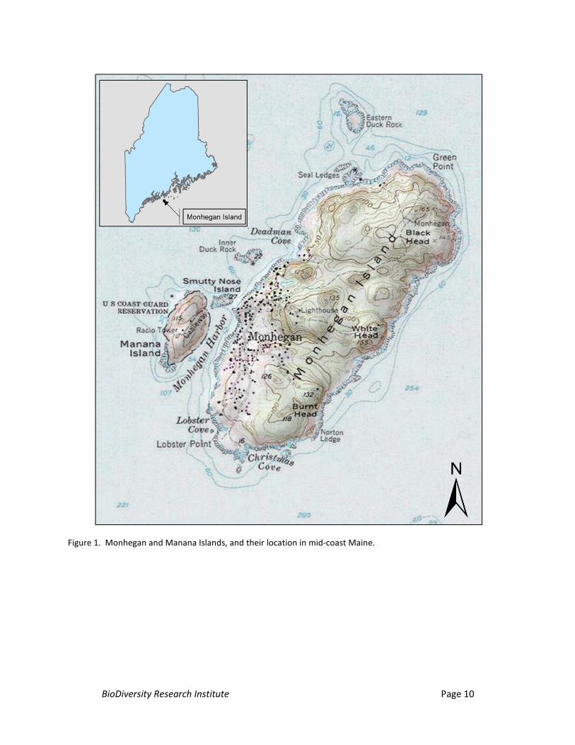
Monhegan Island is a located approximately 10 mi (22 km) offshore in mid-coast Maine in
Lincoln County (Figure 1). It is among the outermost islands strung along Maine’s coastline at varying
distances and is approximately 1.75 mi (2.8 km) long and 0.75 mi. (1.2 km) wide; it is about 1000 acres
(400 ha). Approximately 360 acres of the island are forested with a mixture of dense coniferous and
mixed hardwood stands interspersed among developed and undeveloped open spaces. The island is
approximately 165 ft (50 m) at its highest point at the northern end of the island. Much of Monhegan’s
shoreline consists of rocky cliffs abutting preserved forest land as well as open habitats. Approximately
200 m to the west-central side of Monhegan lays Manana Island, a largely uninhabited island
approximately 600 m long and 300 m wide, with steep inclines on all sides. Manana is comprised almost
entirely of open grassland and shrub habitat and is 115 ft (35 m) at its highest point.
BioDiversity Research Institute Page 10
Figure 1. Monhegan and Manana Islands, and their location in mid-coast Maine.
BioDiversity Research Institute Page 11
4.0 OBJECTIVES
The objectives of this study are to:
(1) Characterize the species composition, timing, intensity, and local flight characteristics of
diurnal raptors at Monhegan Island.
(2) Determine if Northern Saw-whet Owls use Monhegan Island as a stopover during fall
migration, and characterize the timing and intensity of the local owl migration.
(3) Establish an offshore diurnal raptor trapping station to enable the banding, sampling,
and satellite marking of diurnal raptors.
(4) Document flight paths of migratory Peregrine Falcons captured at Monhegan Island
using satellite telemetry.
5.0 METHODS
5.1 Diurnal raptor surveys
We used standard protocols to monitor diurnal raptor migration at Monhegan and Manana
Islands (Figure 2). Protocols were adapted from those used in other hawk migration studies (i.e.,
HawkWatch International, HWI; Hawk Migration Association of North America, HMANA). Observers
conducted counts for 8 hours a day, 7 days a week, from approximately mid-September to mid-October,
as weather permitted. The location of the raptor observation station (“lookout” hereafter) was selected
to maximize the amount of time and directions in which raptors could be viewed as possible. Specific
priority was placed on (a) enabling view of birds’ flight paths relative to the offshore wind
demonstration test site to the south and to the west (MSPOb 2012), and (b) minimizing or eliminating
potential for double counting individuals. Initial counts were conducted from the southern end of the
Monhegan Island near Lobster cove (43.75660 ˚N, 69.32222 ˚W). However, given the flight paths of
raptors in the vicinity and other visibility limitations at Lobster Cove, we determined that the most
optimal location from which to conduct observations was on a high point on Manana Island (43.76316
˚N, 69.32620 ˚W); therefore, we moved the lookout to Manana on 25 September. Data from both of
these lookouts, which are < 0.5 mi (0.8 km) apart, have been combined for the analyses in this report.
Observers identified all migrant raptors to species, age class, and sex as possible. Species or
age/sex classes that were not confirmed by the observer were noted as unknown within that category.
Observers noted the following information on each migrant raptor: time observed (in EST; EDT – 1 hr),

BioDiversity Research Institute Page 12
flight direction (which way the bird is going; N, E, S, W), approximate height from the ground (coded as:
0 = 0 - 100 ft; 1 = 100 - 200 ft; 2 = 200 – 300 ft; 3 = 300 – 400 ft, etc), and lateral distance (direction of
travel and horizontal distance relative to the lookout; approximate distance rounded to the nearest 100
m; Appendix A). Observers prioritized species identification and flight direction data collection during
busy periods. Only raptors observed departing the island were included in the count. Raptors not
exhibiting migratory behavior (i.e., locals) were recorded but are not included in this summary.
After each hour of observation we recorded the following weather variables and data: max
visibility (mi.), temperature (F), percent cloud cover (%), wind speed (mph), wind direction, number of
observers, thermal lift (fair, poor, good, excellent) and number of minutes observed within the hour.
Weather data has not been summarized for the purposes of this report.
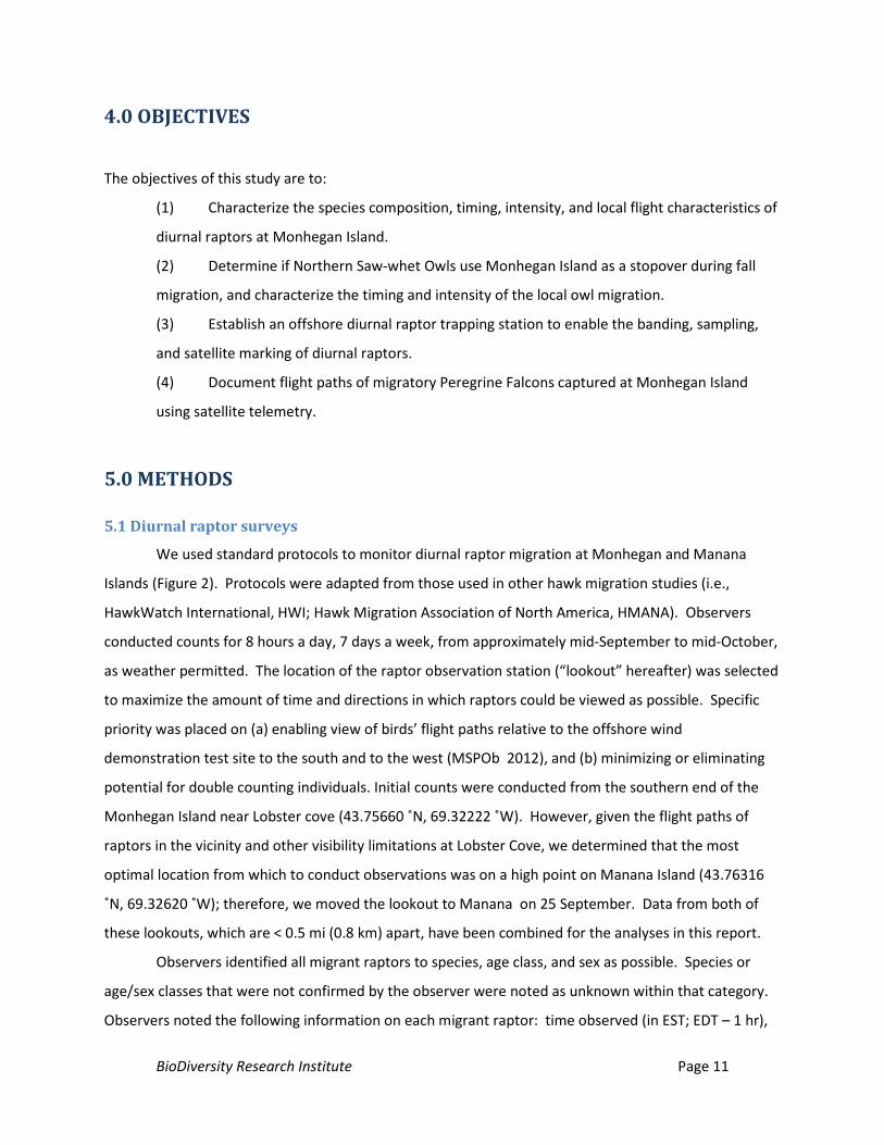
Figure 2. Raptor observer Fred Tilly conducting a fall raptor migration count at Lobster Cove, Monhegan Island,
Maine.
5.2 Nocturnal raptor surveys: Northern saw-whet Owls
To determine if Northern Saw-whet Owls were using Monhegan Island as a migratory stopover
during and gather baseline information, we established an owl banding station on Monhegan Island.
The station, open between 4 and 24 October, consisted of three 12-meter mist nets arranged in a “T”
formation, with a repeating audio lure placed near the center of the net array. The trapping station was
located on Monhegan Island in the Cathedral Woods (43.76656 ˚N, 69.31334 ˚W). We followed
standard protocols in which nets are closed during inclement weather and in cases where predatory
owls (i.e, Barred Owls, Great-horned Owls) are heard in the vicinity. Nets were opened at dusk and
checked approximately hourly until sunrise as weather and staff availability permitted.
Captured owls were extracted from nets, banded, aged, and feather-sampled at a nearby field
banding station prior to release. The sex of individuals was determined using a standardized “wing-mass
BioDiversity Research Institute Page 13
DF” (discriminant function) technique recommended by the Project Owlnet and accepted by the Bird
Banding Lab. Following this protocol, individuals > 93 g were considered females, and < 78 g were
considered males. Owls 79 – 92 g were classified as male, female, or unknown using the DF method
based on unflattened wing cord and body weight (see http://www.projectowlnet.org). Birds were aged
into hatch-year (HY), after hatch-year (AHY), and after second-year (ASY) age classes following standard
protocols that rely upon feather molt and wear to make age assessments (Pyle 1997). Feathers were
evaluated visually under normal lighting conditions as well as under ultraviolet light, which aids in
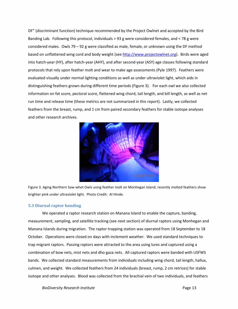
distinguishing feathers grown during different time periods (Figure 3). For each owl we also collected
information on fat score, pectoral score, flattened wing chord, tail length, and bill length, as well as net
run time and release time (these metrics are not summarized in this report). Lastly, we collected
feathers from the breast, rump, and 1 cm from paired secondary feathers for stable isotope analyses
and other research archives.
Figure 3. Aging Northern Saw-whet Owls using feather molt on Monhegan Island; recently molted feathers show
brighter pink under ultraviolet light. Photo Credit: Al Hinde.
5.3 Diurnal raptor banding
We operated a raptor research station on Manana Island to enable the capture, banding,
measurement, sampling, and satellite tracking (see next section) of diurnal raptors using Monhegan and
Manana Islands during migration. The raptor trapping station was operated from 18 September to 18
October. Operations were closed on days with inclement weather. We used standard techniques to
trap migrant raptors. Passing raptors were attracted to the area using lures and captured using a
combination of bow nets, mist nets and dho gaza nets. All captured raptors were banded with USFWS
bands. We collected standard measurements from individuals including wing chord, tail length, hallux,
culmen, and weight. We collected feathers from 24 individuals (breast, rump, 2 cm retrices) for stable
isotope and other analyses. Blood was collected from the brachial vein of two individuals, and feathers
BioDiversity Research Institute Page 14
were collected from 24 individuals. Findings from feather and blood sample analyses are not presented
in this report. A primary objective of establishing the trapping station was to (a) enable the fitting of
satellite units to migrant peregrine falcons (methodology for that effort is presented below), and (b) find
a field site to serve as a future raptor research station to be used in future research and monitoring
efforts. All required state and federal permits were obtained prior to conducting field research.
5.4 Satellite tracking Peregrine Falcons
We fitted two migrant juvenile Peregrine Falcons with 22g solar GPS satellite transmitters (or
Platform Transsmitter Terminals; PTTs; manufactured by North Star Science and Technology) to gain
insights on bird movements at various scales and to link individuals to wintering areas. Units were
programmed with two alternating seasons. During season 1, transmitters were programmed to an 8 hr
on, 90 hr off duty cycle, while fixing GPS locations (in EST) at: 8:00 am (1300 GMT), 11:00 am (1600
GMT), 2:00 pm (1900 GMT), and 5:00 pm (2200 GMT), and 07:00 pm (0:00 GMT). Transmitters fixed one
GPS location at 1:00 EST (1800 GMT) daily after 1 December during season 2. Solar GPS PTTs produce
both GPS locations and ‘doppler’ locations. The accuracy of GPS fixes is considered to be approximately
< 26 m; GPS fixes comprise the bulk of the location data used in analyses. Only doppler location classes
L2 (149 m < accuracy < 350 m) and L3 (accuracy < 150 m) were considered in movement analyses in this
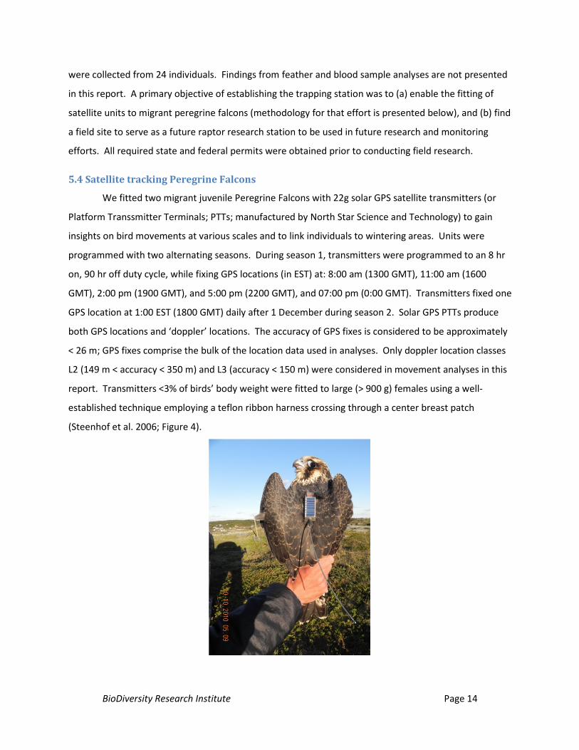
report. Transmitters <3% of birds’ body weight were fitted to large (> 900 g) females using a well-
established technique employing a teflon ribbon harness crossing through a center breast patch
(Steenhof et al. 2006; Figure 4).
BioDiversity Research Institute Page 15
Figure 4. Juvenile female Peregrine Falcon fitted with a solar GPS satellite unit on Manana Island, Maine, fall 2010.
We received ≥ four locations a day from this individual, and tracked its daily movements between Monhegan
Island and Columbia.
6.0 RESULTS
6.1 Diurnal raptor surveys
We observed raptors at the study site for a total of 188.4 hours between 15 September and 18
October. Inclement weather restricted visibility and closed observations on 3 potential observation
days. Rain, fog, and/or strong south winds limited counts on 24 September, 30 September, and 1
October. Counts were not conducted on 15 and 16 October due to staff limitations toward the
conclusion of the project. Our count data is presented in raw form, rather than hawks per hour.
Observations were typically conducted when weather permitted during most of the period. Hawk count
data from this project will be made available at www.hawkcount.org.
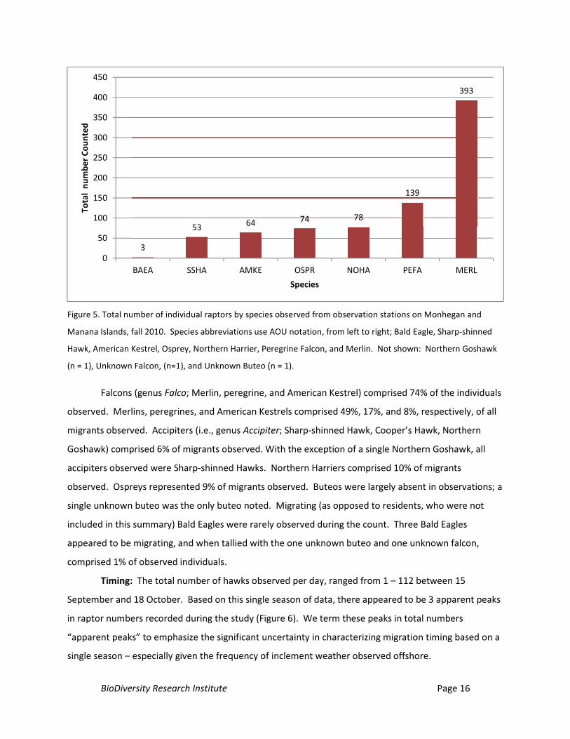
Counts and species composition: We documented a total of 807 diurnal raptors of 8 species
migrating through the Monhegan Island vicinity during observations (Figure 5). The two most abundant
raptors observed were falcons. Merlins were the most abundant migrant observed; Peregrine Falcons
(peregrine hereafter) were the second most common raptor observed. Other species observed were
Northern Harrier, Osprey, American Kestrel, Sharp-shinned Hawk, Bald Eagle, and Northern Goshawk.
All individuals were identified to species with the exception of two individuals, which were classified as
an unknown falcon, and an unknown buteo.
BioDiversity Research Institute Page 16
Figure 5. Total number of individual raptors by species observed from observation stations on Monhegan and
Manana Islands, fall 2010. Species abbreviations use AOU notation, from left to right; Bald Eagle, Sharp-shinned
Hawk, American Kestrel, Osprey, Northern Harrier, Peregrine Falcon, and Merlin. Not shown: Northern Goshawk
(n = 1), Unknown Falcon, (n=1), and Unknown Buteo (n = 1).
Falcons (genus Falco; Merlin, peregrine, and American Kestrel) comprised 74% of the individuals
observed. Merlins, peregrines, and American Kestrels comprised 49%, 17%, and 8%, respectively, of all
migrants observed. Accipiters (i.e., genus Accipiter; Sharp-shinned Hawk, Cooper’s Hawk, Northern
Goshawk) comprised 6% of migrants observed. With the exception of a single Northern Goshawk, all
accipiters observed were Sharp-shinned Hawks. Northern Harriers comprised 10% of migrants
observed. Ospreys represented 9% of migrants observed. Buteos were largely absent in observations; a
single unknown buteo was the only buteo noted. Migrating (as opposed to residents, who were not
included in this summary) Bald Eagles were rarely observed during the count. Three Bald Eagles
appeared to be migrating, and when tallied with the one unknown buteo and one unknown falcon,
comprised 1% of observed individuals.
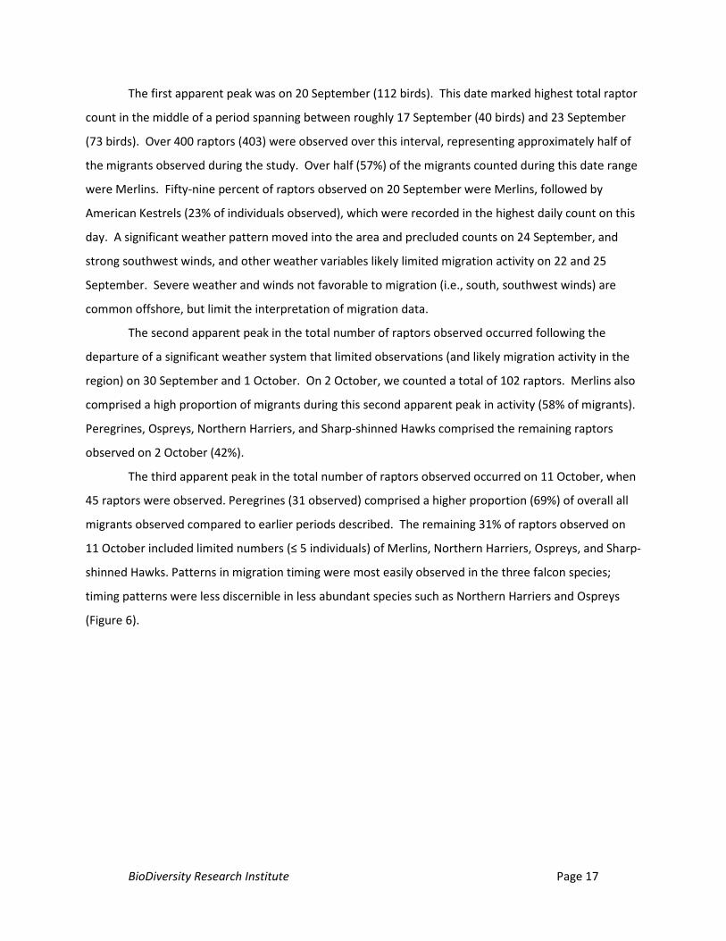
Timing: The total number of hawks observed per day, ranged from 1 – 112 between 15
September and 18 October. Based on this single season of data, there appeared to be 3 apparent peaks
in raptor numbers recorded during the study (Figure 6). We term these peaks in total numbers
“apparent peaks” to emphasize the significant uncertainty in characterizing migration timing based on a
single season – especially given the frequency of inclement weather observed offshore.
3
53 64 74 78
139
393
0
50
100
150
200
250
300
350
400
450
BAEA SSHA AMKE OSPR NOHA PEFA MERL
Tota
l nu
mbe
r Cou
nted
Species
BioDiversity Research Institute Page 17
The first apparent peak was on 20 September (112 birds). This date marked highest total raptor
count in the middle of a period spanning between roughly 17 September (40 birds) and 23 September
(73 birds). Over 400 raptors (403) were observed over this interval, representing approximately half of
the migrants observed during the study. Over half (57%) of the migrants counted during this date range
were Merlins. Fifty-nine percent of raptors observed on 20 September were Merlins, followed by
American Kestrels (23% of individuals observed), which were recorded in the highest daily count on this
day. A significant weather pattern moved into the area and precluded counts on 24 September, and
strong southwest winds, and other weather variables likely limited migration activity on 22 and 25
September. Severe weather and winds not favorable to migration (i.e., south, southwest winds) are
common offshore, but limit the interpretation of migration data.
The second apparent peak in the total number of raptors observed occurred following the
departure of a significant weather system that limited observations (and likely migration activity in the
region) on 30 September and 1 October. On 2 October, we counted a total of 102 raptors. Merlins also
comprised a high proportion of migrants during this second apparent peak in activity (58% of migrants).
Peregrines, Ospreys, Northern Harriers, and Sharp-shinned Hawks comprised the remaining raptors
observed on 2 October (42%).
The third apparent peak in the total number of raptors observed occurred on 11 October, when
45 raptors were observed. Peregrines (31 observed) comprised a higher proportion (69%) of overall all
migrants observed compared to earlier periods described. The remaining 31% of raptors observed on
11 October included limited numbers (≤ 5 individuals) of Merlins, Northern Harriers, Ospreys, and Sharp-
shinned Hawks. Patterns in migration timing were most easily observed in the three falcon species;
timing patterns were less discernible in less abundant species such as Northern Harriers and Ospreys
(Figure 6).
BioDiversity Research Institute Page 18
Figure 6. Migration timing of diurnal raptors observed in fall 2010 from Monhegan and Manana Islands, Maine. * Other = Bald Eagle (n = 3), Northern Goshawk
(n = 1), UB = Unknown Buteo (n = 1), UF = Unknown Falcon (n = 1). Counts were not conducted (primarily due to weather: 22, 24, 25, 30 Sept.; 1, 15, 16 Oct.
0
20
40
60
80
100
120
15-S
ep-1
016
-Sep
-10
17-S
ep-1
018
-Sep
-10
19-S
ep-1
020
-Sep
-10
21-S
ep-1
022
-Sep
-10
23-S
ep-1
0
24-S
ep-1
025
-Sep
-10
26-S
ep-1
027
-Sep
-10
28-S
ep-1
029
-Sep
-10
30-S
ep-1
0
1-O
ct-1
02-
Oct
-10
3-O
ct-1
04-
Oct
-10
5-O
ct-1
06-
Oct
-10
7-O
ct-1
08-
Oct
-10
9-O
ct-1
010
-Oct
-10
11-O
ct-1
012
-Oct
-10
13-O
ct-1
0
14-O
ct-1
015
-Oct
-10
16-O
ct-1
017
-Oct
-10
18-O
ct-1
0
Num
ber o
f rap
tors
obs
erve
d
Date
other, UB, UFSSHAPEFAOSPRNOHAMERLAM.KE
BioDiversity Research Institute Page 19
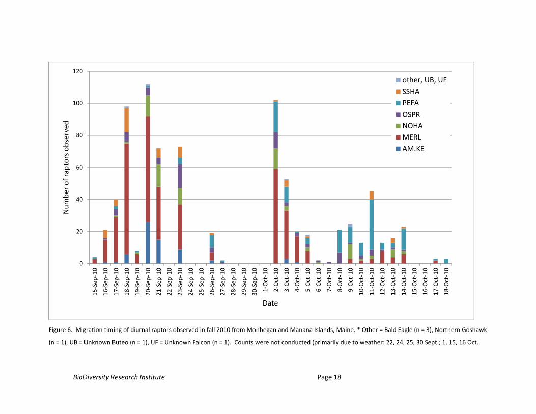
Flight Direction: We noted flight direction for 791 of the migrants observed during the raptor
count. The vast majority of raptors observed from the lookout contained a westerly component to their
flight direction (Figure 7). The highest proportion of migrants were observed departing to the west
(34%), followed by those departing to the southwest (31%). Approximately 88% of all raptors observed
flying in a fairly relatively narrow range of directions ranging between 255° - 270° (west, southwest, or
west-southwest). Unsurprisingly, very few raptors were observed flying due north (1 individual; <1%) or
north-northwest (2 individuals; <1%). We observed two individuals (<1 %) flying directly south. We did
not observe any raptors with an easterly component to its migration.
Figure 7. Flight direction of 791 raptor migrants observed from Monhegan and Manana Islands during fall 2010
migration.
Height: Observers noted approximate flight height of 798 passing migrant raptors. The majority
of migrant raptors were observed between 0 – 200 ft (0 – 61 m). Of all passing migrants, 579 (73%)
were categorized as flying between 0 – 100 ft (0 – 30 m), and 101 raptors (15%) were noted to fly
between 100 – 200 ft (30 – 61 m). Fifty raptors (6%) were categorized as flying between 200 - 300 ft (61
- 91 m). Thirty-six raptors (5%) were noted as flying between 300 – 400 ft (91 - 122 m), and 12 raptors
(1%) were noted at a height >400 ft (>122 m).
Lateral Distance: Observers noted the lateral distance for 532 raptors passing the lookout. The
lateral distance roughly denotes the direction of travel and distance of passing migrants relative to the
location of the lookout. Birds passed the lookout in all four cardinal directions. The highest proportion
(45%, 237 birds) of raptors passed to the west of the lookout. Thirty percent (160 birds) passed to the
north, 19% (99 birds) passed to the south, and 7% (36 birds) passed to the east of the lookout.
The distance at which raptors passed the lookout varied widely among species. Distance codes,
recorded in the field at 100 m increments and rounded to the nearest 100 m, are combined for this data
NW N
WNW
W E
WSW
SW S
88%
BioDiversity Research Institute Page 20
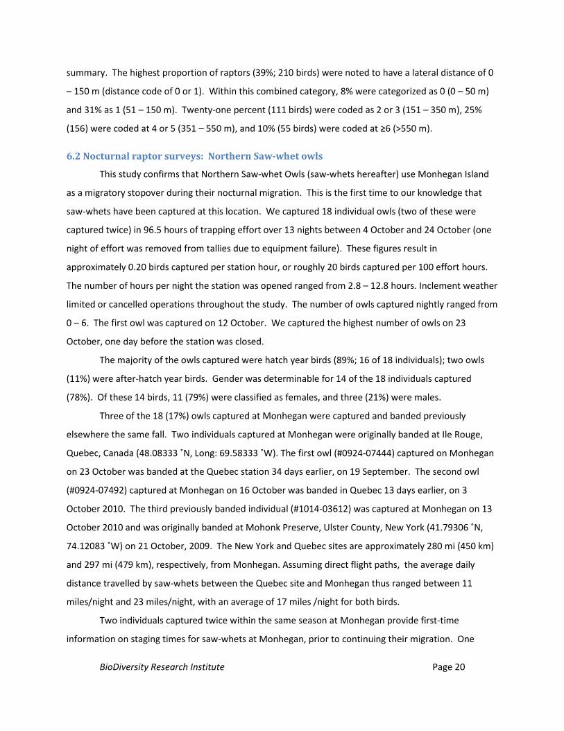
summary. The highest proportion of raptors (39%; 210 birds) were noted to have a lateral distance of 0
– 150 m (distance code of 0 or 1). Within this combined category, 8% were categorized as 0 (0 – 50 m)
and 31% as 1 (51 – 150 m). Twenty-one percent (111 birds) were coded as 2 or 3 (151 – 350 m), 25%
(156) were coded at 4 or 5 (351 – 550 m), and 10% (55 birds) were coded at ≥6 (>550 m).
6.2 Nocturnal raptor surveys: Northern Saw-whet owls
This study confirms that Northern Saw-whet Owls (saw-whets hereafter) use Monhegan Island
as a migratory stopover during their nocturnal migration. This is the first time to our knowledge that
saw-whets have been captured at this location. We captured 18 individual owls (two of these were
captured twice) in 96.5 hours of trapping effort over 13 nights between 4 October and 24 October (one
night of effort was removed from tallies due to equipment failure). These figures result in
approximately 0.20 birds captured per station hour, or roughly 20 birds captured per 100 effort hours.
The number of hours per night the station was opened ranged from 2.8 – 12.8 hours. Inclement weather
limited or cancelled operations throughout the study. The number of owls captured nightly ranged from
0 – 6. The first owl was captured on 12 October. We captured the highest number of owls on 23
October, one day before the station was closed.
The majority of the owls captured were hatch year birds (89%; 16 of 18 individuals); two owls
(11%) were after-hatch year birds. Gender was determinable for 14 of the 18 individuals captured
(78%). Of these 14 birds, 11 (79%) were classified as females, and three (21%) were males.
Three of the 18 (17%) owls captured at Monhegan were captured and banded previously
elsewhere the same fall. Two individuals captured at Monhegan were originally banded at Ile Rouge,
Quebec, Canada (48.08333 ˚N, Long: 69.58333 ˚W). The first owl (#0924-07444) captured on Monhegan
on 23 October was banded at the Quebec station 34 days earlier, on 19 September. The second owl
(#0924-07492) captured at Monhegan on 16 October was banded in Quebec 13 days earlier, on 3
October 2010. The third previously banded individual (#1014-03612) was captured at Monhegan on 13
October 2010 and was originally banded at Mohonk Preserve, Ulster County, New York (41.79306 ˚N,
74.12083 ˚W) on 21 October, 2009. The New York and Quebec sites are approximately 280 mi (450 km)
and 297 mi (479 km), respectively, from Monhegan. Assuming direct flight paths, the average daily
distance travelled by saw-whets between the Quebec site and Monhegan thus ranged between 11
miles/night and 23 miles/night, with an average of 17 miles /night for both birds.
Two individuals captured twice within the same season at Monhegan provide first-time
information on staging times for saw-whets at Monhegan, prior to continuing their migration. One
BioDiversity Research Institute Page 21
individual (#1014-03612) first captured on 13 October was captured again 3 days (72.4 hrs) later on 16
October. A second individual (#1014-34608) captured on 17 October was recaptured one day (22.4 hrs)
later on 18 October. One owl retrapped on Monhegan individual increased its body mass by 3%
between captures (+3.3 g in 22.4 hrs), while the body mass of the other individual decreased by 0.6%
between captures (-0.5 g in 72.4 hrs).
6.3 Diurnal raptor banding
We captured 25 raptors of 3 species during the operation of the diurnal raptor trapping station
at Manana Island (Table 1). All species captured were juvenile falcons. Peregrines were the most
commonly captured species, followed by Merlins and American Kestrels. We captured more female
than male peregrines and Merlins, and an equal number of American Kestrels.
Table 1. Sample sizes and body mass (g) of diurnal raptors captured at Manana Island, Maine, fall 2010.
Female (g) Male (g) Species n Mean (n) Range (g) Mean (n) Range (g) AMKE 2 96 (1) n/a 100 (1) n/a MERL 6 199 (5) 186 - 218 150 (1) 150 PEFA 17 871 (13) 736 - 1070 509 (4) 396 - 582 Total 25
The mass of migrants fell within expected ranges for all individuals within each species with the
exception of one male peregrine. This individual (396 g) was considered emaciated upon evaluation in
the field, and it was later recovered on the island (see Discussion, section 7.4).
6.4 Satellite tracking Peregrine Falcons
We fitted two juvenile female migrant Peregrines with GPS satellite transmitters to document
daily movements of peregrines captured at Monhegan, and to associate migrants captured at
Monhegan with wintering populations. We did not deploy our third transmitter in hopes of catching an
adult female (this unit will be deployed in 2012). Satellite data below have been converted from
Greenwich Mean Time (GMT) to Eastern Daylight Time (GMT – 5 hrs). All location data below should be
considered preliminary pending more detailed processing and analysis of movement data.
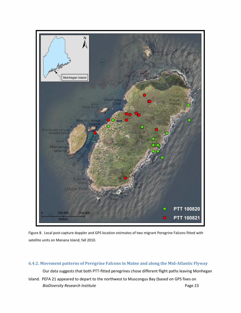
6.4.1. Local movement patterns of Peregrine Falcons on Monhegan Island
While the programming of transmitters used in this study prioritized documenting regional and
long-distance movements, PTT location data provided some insights on the duration of time spent and
BioDiversity Research Institute Page 22
local movement patterns of peregrines on Monhegan. Information on local movement patterns for the
two PTT-fitted Peregrines are described below.
PTT # 100820 (PEFA 20 hereafter): We captured this juvenile female peregrine on 9 October
2010. PEFA 20 spent two nights on Monhegan subsequent to capture. PTT data suggests PEFA 20
utilized the eastern shore of the island, including Black Head, White Head, as well as the forested island
interior, throughout 10 October (Figures 1, 8). By 8:00 AM the morning of 11 October, PEFA 20 fixed a
GPS location approximately 2.8 miles (4.5 km) to the southwest of the island in the open ocean, and by
11 AM a location was fixed approximately 48 miles (77.1 km) southwest on the mainland in Cape
Elizabeth, ME. The distance of the 8:00 AM fix from the island and the distance travelled between this
location and the 11:00 AM location in Cape Elizabeth suggests the 8:00 AM fix occurred as the bird
departed the island. The minimum staging time for PEFA 20, calculated using 7:00 PM on the capture
day, to sunrise on the day of the bird’s departure, was 36 hrs.
PTT # 100821 (PEFA 21 hereafter): We captured this juvenile female peregrine on 5 October
2010. PEFA 21 spent two nights on Monhegan following release. GPS fixes were located on the high
ground southeast of Deadman Cove on the eastern shore of the island, the southeast corner, and the
center of the forest in the northern third of the island (Figures 1, 8). At 8:00 AM on 9 October, PEFA 21
fixed a GPS location west of Black Head in the central northern forests on the island. By 11:00 AM, the
bird fixed a location on Wreck Island (a small island between Harbor Island and Marsh Island in
Muscongus Bay), approximately 8.7 miles (14 km) to the northwest of Monhegan Island. The minimum
staging time for PEFA 21, calculated using 7:00 PM the capture day to the 8:00 AM fix on the day of the
bird’s departure is 37 hours.
BioDiversity Research Institute Page 23
Figure 8. Local post-capture doppler and GPS location estimates of two migrant Peregrine Falcons fitted with
satellite units on Manana Island, fall 2010.
6.4.2. Movement patterns of Peregrine Falcons in Maine and along the Mid-Atlantic Flyway
Our data suggests that both PTT-fitted peregrines chose different flight paths leaving Monhegan
Island. PEFA 21 appeared to depart to the northwest to Muscongus Bay (based on GPS fixes on
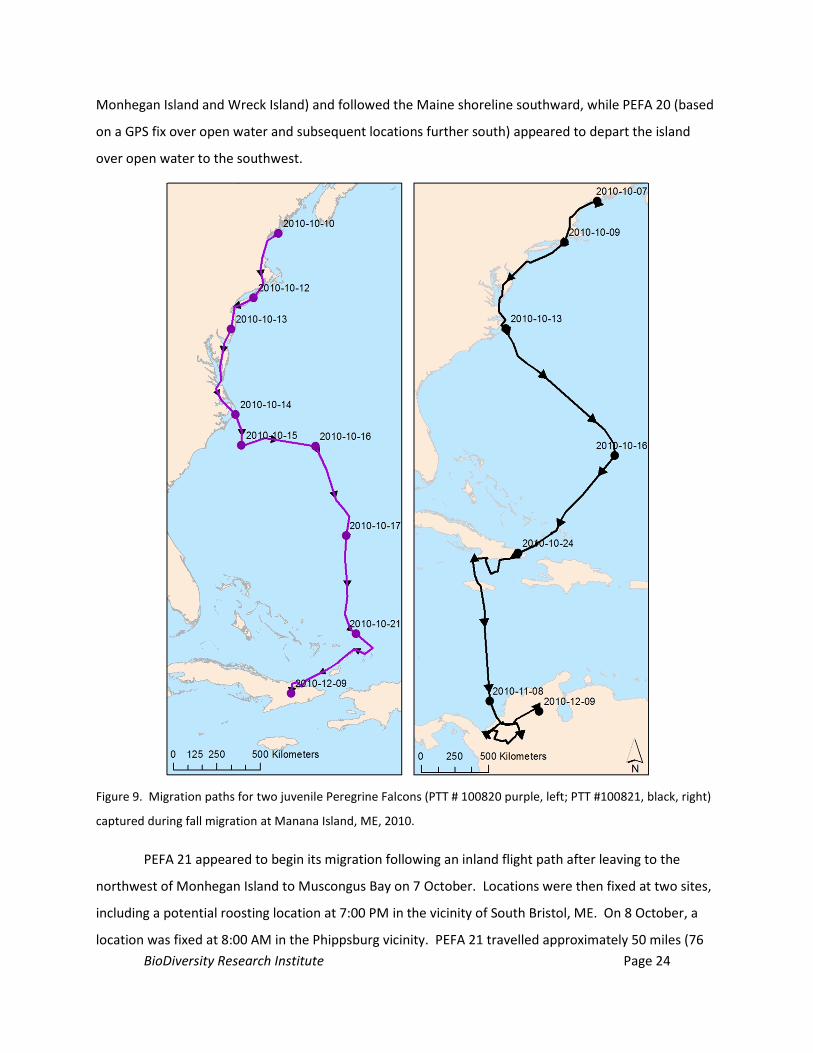
BioDiversity Research Institute Page 24
Monhegan Island and Wreck Island) and followed the Maine shoreline southward, while PEFA 20 (based
on a GPS fix over open water and subsequent locations further south) appeared to depart the island
over open water to the southwest.
Figure 9. Migration paths for two juvenile Peregrine Falcons (PTT # 100820 purple, left; PTT #100821, black, right)
captured during fall migration at Manana Island, ME, 2010.
PEFA 21 appeared to begin its migration following an inland flight path after leaving to the
northwest of Monhegan Island to Muscongus Bay on 7 October. Locations were then fixed at two sites,
including a potential roosting location at 7:00 PM in the vicinity of South Bristol, ME. On 8 October, a
location was fixed at 8:00 AM in the Phippsburg vicinity. PEFA 21 travelled approximately 50 miles (76
BioDiversity Research Institute Page 25
km) over the next three hours to a forested area roughly 2.4 miles (3.9 km) north of West Kennebunk,
ME, where it fixed a location at 11:00 AM. From West Kennebunk, the bird appeared to follow an inland
migration route that tracked South of Kingston, NH, and north of Salem, NH, where it may have roosted.
From this point, the peregrine travelled southward through eastern MA toward Providence and
Narragansett, RI. PEFA 21 fixed a GPS location on Block Island, RI, migrated over open water parallel to
Long Island, NY, and fixed several GPS and Doppler locations on the west side of Barnegat Bay, NJ in the
early evening on 9 October. The next fix on this individual was on 10 October at 8:00 AM approximately
8.4 miles (13 km) southwest of Salisbury, MD. It is unknown if the peregrine crossed Delaware Bay or
followed an inshore route to the west. The next several location fixes suggested the peregrine travelled
nearly due south (to the west of Assateague Island and Chincoteague Bay, known peregrine stopovers)
to the eastern side of Chesapeake Bay, following the Chesapeake Bay Peninsula, crossing Chesapeake
Bay, and fixing a location just north of Virginia Beach, VA at 11:00 AM on 11 October, and fixing several
early evening locations in Mackay Island National Wildlife Refuge, NC. Over the course of the 12 and 13
October, the peregrine generally followed the eastern NC shoreline destined for Cape Hatteras, NC,
where numerous locations were fixed, including overnight locations on 14 October.
PEFA 21 departed the continental U.S. on 15 October, tracking southeast over open ocean for
the next two days. This journey took the bird 715 miles (1,150 km) (approximately 300 miles [428 km]
to the southwest of Bermuda) to the southeast, before it turned southwest and travelled another 414
miles (666 km), to fix a location in Turks and Caicos on 17 October. After spending approximately 5 days
in Turks and Caicos (to 22 September). PEFA 21 spent a few days on Great Inagua Island (to 24
September), after which it spent the remainder of September and all of October along the southern
shore of Cuba. The last Cuban location for PEFA 21 was in the early evening on 7 November. PEFA 21
fixed a location on Jamaica, and left Jamaica to make landfall at La Rada on the northwest shore of
Colombia between 8:00 AM (an open ocean satellite fix) and 11:00 AM on 8 November. Daily locations
were fixed on this peregrine in northern Columbia throughout the remainder of 2010 into the Spring of
2011. The last data we received from this PTT was on 12 March, 2011. As is often the case with PTT
data, the reasons for discontinued transmissions for PEFA 21 are unclear.
PEFA 20 departed Monhegan on 11 October, fixing a location at 8:00 AM approximately 2.8
miles (4.5 km) to the southwest of the island in the open ocean. By 11:00 AM on the same day, PEFA 20
fixed a location approximately 48 miles (77.1 km) to the southwest on the mainland, inshore between
Scarborough Marsh and Higgins Beach, ME. The bird continued southward, fixing two locations
southwest of Boston, MA; locations suggest the bird may have roosted east of Medway, MA, roughly
BioDiversity Research Institute Page 26
153 miles (246 km) from Monhegan Island. PEFA 20 fixed a location at 8:00 AM on the beach south of
Narragansett, RI, and then 11:00 AM near Southhampton, NY on 12 October. It is unknown if the
peregrine flew to Block Island similar to PEFA 20. Location fixes on this individual indicate the bird
followed the length of Long Island, and may have roosted in a forested area approximately 5.0 miles (8.2
km) west of Queens, NY. Locations were fixed on PEFA 20 several miles south of Barnegat Bay, NJ, and
then over open water in western Delaware Bay at 11:00 AM on 13 October. These locations suggest the
bird crossed Delaware Bay rather than choosing an inshore route. PEFA 20 fixed several locations in
Pocomoke Bay in eastern Chesapeake Bay and near Cape Charles, MD on 14 October. These locations
indicate that the individual did not follow the eastern shoreline of Delaware or southern Maryland, but
chose a westerly route near Chesapeake Bay. The bird continued on this inland route as it fixed
locations approximately 7 miles (11 km) west of Suffolk, VA, 1.6 miles (2.7 km) north of New Hope, NC.
Early evening locations suggest the bird may have roosted near the center of Cape Hatteras, NC on 14
October.
PEFA 20 departed the continental U.S. on 15 October, and spent approximately two days
following a flight path east, then south (Figure 9). The first known satellite fix over land since its
departure from North Carolina was in El Salvador on 18 October at 8:00 AM. The bird spent the evening
of 19 October in El Salvador prior to departing to the east on 20 October. On 21 October, PEFA 20 fixed
a location in Turks and Caicos, where it stayed until 23 October, prior to departing for Little Inagua
Island. On 24 October, PEFA 20 flew from Little Inagua Island to eastern Cuba. PEFA 21 fixed daily
locations throughout eastern Cuba until the last transmission on 6 March 2011. The reasons for the
discontinuation of transmissions from PEFA 20 are unknown.
7.0 DISCUSSION
To our knowledge, this study marks the first standardized raptor migration survey that has been
conducted on Monhegan Island, and it is likely one of the only comprehensive raptor surveys using
standardized techniques that has been conducted in Maine’s offshore environment. This study has also
provided potentially the first GPS quality data on migrating peregrines in Maine as well as other New
England and Mid-Atlantic states. Below, we summarize interpretations of the findings of this study
within study components.
BioDiversity Research Institute Page 27
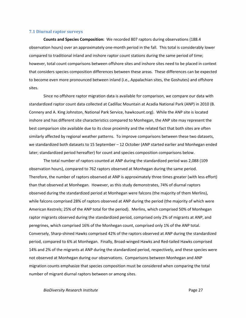
7.1 Diurnal raptor surveys
Counts and Species Composition: We recorded 807 raptors during observations (188.4
observation hours) over an approximately one-month period in the fall. This total is considerably lower
compared to traditional inland and inshore raptor count stations during the same period of time;
however, total count comparisons between offshore sites and inshore sites need to be placed in context
that considers species composition differences between these areas. These differences can be expected
to become even more pronounced between inland (i.e., Appalachian sites, the Goshutes) and offshore
sites.
Since no offshore raptor migration data is available for comparison, we compare our data with
standardized raptor count data collected at Cadillac Mountain at Acadia National Park (ANP) in 2010 (B.
Connery and A. King Johnston, National Park Service, hawkcount.org). While the ANP site is located
inshore and has different site characteristics compared to Monhegan, the ANP site may represent the
best comparison site available due to its close proximity and the related fact that both sites are often
similarly affected by regional weather patterns. To improve comparisons between these two datasets,
we standardized both datasets to 15 September – 12 October (ANP started earlier and Monhegan ended
later; standardized period hereafter) for count and species composition comparisons below.
The total number of raptors counted at ANP during the standardized period was 2,088 (109
observation hours), compared to 762 raptors observed at Monhegan during the same period.
Therefore, the number of raptors observed at ANP is approximately three times greater (with less effort)
than that observed at Monhegan. However, as this study demonstrates, 74% of diurnal raptors
observed during the standardized period at Monhegan were falcons (the majority of them Merlins),
while falcons comprised 28% of raptors observed at ANP during the period (the majority of which were
American Kestrels; 25% of the ANP total for the period). Merlins, which comprised 50% of Monhegan
raptor migrants observed during the standardized period, comprised only 2% of migrants at ANP, and
peregrines, which comprised 16% of the Monhegan count, comprised only 1% of the ANP total.
Conversely, Sharp-shined Hawks comprised 42% of the raptors observed at ANP during the standardized
period, compared to 6% at Monhegan. Finally, Broad-winged Hawks and Red-tailed Hawks comprised
14% and 2% of the migrants at ANP during the standardized period, respectively, and these species were
not observed at Monhegan during our observations. Comparisons between Monhegan and ANP
migration counts emphasize that species composition must be considered when comparing the total
number of migrant diurnal raptors between or among sites.
BioDiversity Research Institute Page 28
In general, the suite of diurnal migrant raptor species observed at Monhegan is comprised of
species known to use powered flight (flapping and gliding) over soaring during migration (Spaar 1997).
Species relying on powered flight often have lower wing loads compared to species relying on soaring
flight (Newton 2008). Species such as Broad-winged Hawks, Red-tailed Hawks, and Cooper’s Hawks
characteristically migrate by gaining altitude on thermals and gliding between them; none of these
species were observed at Monhegan during our count. Thermals are poorly developed and widely
spaced in the coastal environment. The raptors observed at Monhegan during our count generally
include all of the small North American raptors (i.e., Merlin, American kestrel, and Sharp-shinned Hawk)
that can overcome the lack of thermals during favorable wind conditions. These raptors can be quickly
overpowered by strong headwinds, and resultantly, the migration patterns of the small raptors can be
especially influenced by prevailing wind direction and other weather variables.
A secondary factor that likely contributes to influencing differences in species composition
between offshore and inshore sites relates to their dietary preferences and their ability to feed during
migration. Many of the raptors observed at Monhegan (i.e., peregrines, Merlins, Sharp-shinned Hawks,
American Kestrels) are known to partially or exclusively feed upon birds, and in some species
invertebrates (i.e., dragonflies, butterflies). In general, the migration timing and flight paths of many
raptors coincides with that of songbirds and shorebirds (Aborn 1994, White et al. 2002) and/or the
migrations of invertebrate prey, and it is plausible that these food resources help sustain predators
during migration.
Migration Timing: While the timing of the fall raptor migration at Monhegan is generally known
among biologists and birders, it has not been previously quantified and documented through continuous
standardized raptor surveys. Given its northerly location the timing of the raptor migration on
Monhegan appears comparable with that of similar species at other sites along the Atlantic migratory
flyway (i.e., Hawk Mountain, PA, Cape May, NJ). A severe weather system moved into in the vicinity
during late September, bringing high south winds, fog, and/or limited visibility. This system halted
counts (and most likely the regional raptor migration itself) and lessens our ability to clearly interpret
the timing of the migration at Monhegan. Adverse weather will be a consistent factor influencing most
migration studies, particularly in the marine environment.
Our surveys suggest three peaks in the total number of raptor migrants visible from Monhegan:
one in mid-September (20 September; 112 birds counted), a second in early October (1 October; 102
birds), and a third just before mid-October (11 October; 45 birds) (Figure 6). Clear increases and
subsequent decreases were most discernible in the three falcon species (American Kestrels, Merlins, and
BioDiversity Research Institute Page 29
peregrines), which comprised the majority of the migrants observed (Figure 6). The first peak in the
total daily count at Monhegan was primarily comprised by Merlins. The daily count of American Kestrels
was highest for the season on this day as well, although lower numbers compared to Merlins. The
pattern suggestive of a mid-September peak in total daily counts at Monhegan was also evident at ANP.
In contrast to Monhegan, the first peak at ANP was heavily comprised of American Kestrels (49% of daily
total) and Sharp-shinned Hawks (32%); Merlins were relatively rare (2%).
The second peak in daily counts at Monhegan (2 October) was also evident at the ANP site one
day later. However, while 58% of the raptors counted at Monhegan on this second peak were Merlins
(and 1% were Sharp-shinned hawks; 19% were Peregrines), 53% of the raptors counted during the
second peak at ANP were Sharp-shinned Hawks (and 3% were Merlins, 16% were Broad-winged Hawks).
Merlin counts declined to <10 individuals/day by 5 October at Monhegan, and never surpassed this level
for the remainder of the count. The third peak at Monhegan occurred on 11 October, when we tallied
the highest daily peregrine count of 31 individuals. Daily observations of 1 – 13 peregrines continued to
end of the count. Counts at ANP also show a third peak in raptor activity on 12 October, the final day of
their count. The ANP daily total was primarily comprised by Sharp-shinned Hawks, while the Monhegan
total was dominated by peregrines.
The concordance of the general timing of raptor movements at the Monhegan and ANP sites
despite notable differences in species composition between them may suggest that weather conditions
or other factors are similarly influencing raptors’ cues to migrate at both sites. Raptor migration surveys
at ANP and Monhegan were similarly limited by adverse weather over the 24 September - 1 October,
and further surveys will be required to evaluate the extent to which this storm influenced species-
specific timing patterns observed in 2010. As is typically observed at other sites, northwest winds
favored migratory activity, while south winds severely limited raptor migration. Future counts starting
earlier (i.e, mid August or 1 September) would improve characterizations of the migratory patterns of
the smaller raptors (i.e., Merlins, American Kestrels, and Sharp-shinned Hawks) at Monhegan. The
highest daily count for Sharp-shinned Hawks at ANP occurred on 11 September, before the onset of our
counts on Monhegan. Seventy-two percent of the total number of raptors counted at ANP between 1
September and 14 September were American Kestrels (27% of total) and Sharp-shinned Hawks (45%) (A.
King Johnston, NPS, unpublished data; hawkcount.org). Significant population level declines have been
recently detected in both of these species (Bildstein et al. 2008), and improving our understanding of
these species is warranted.
BioDiversity Research Institute Page 30
Flight Direction, Height, and Lateral Distance
A thorough understanding of local raptor flight characteristics such as height and flight direction
is important in evaluating the potential for collision risk with proposed construction projects, and
equally important, measuring behavior changes post-construction.
Flight Direction: Our migration surveys indicated that all migrants visible from the lookout had
a westerly component to their flight direction, with 87% of raptor migrants observed flying between
255° – 270° (west, west-southwest, or southwest). A relatively small proportion of migrants (11%) was
observed flying either Northwest or West-Northwest, and no raptors were observed flying north, south,
or east. Raptors departing the island at low altitudes to the east or south may have been difficult to
detect by observers; however, we suspect these cases were rare as few raptors would “disappear”
behind the island during counts – especially during days with more notable movements. Flight
directions observed at Monhegan may suggest that migrant raptors passing through the area are
targeting visible islands (such as Seguin Island) or the mainland upon departure. While peregrines have
been observed offshore (White et al. 2002, ), and the species is clearly capable of making large open
water crossings, the departure directions chosen by migrants in this study might be expected given the
broader geographic context of potential southward stopover locations and final destinations. Due to
the western retreat of the north Atlantic coastline, the easternmost point of land south of Monhegan is
the eastern tip of Cape Cod, MA, which lies roughly147 miles (236 km) in a direction of 192 degrees.
This point represents the easternmost point at which migrants departing Monhegan might be
considered to stop if they attempted a point-to-point flight over open water. No birds in our study
ventured in this direction; most favored westerly flight paths toward the coast.
Height: This study provides baseline information on passing raptor flight height of 798 migrants
at Monhegan Island. Seventy-three percent of the migrants observed in this study were noted to fly at
heights between 0 – 100 ft (0 – 30 m), 15% were between 100 – 200 ft (30-61 m), and the remaining
12% were above 200 ft (further details in results). Similar findings reporting flight heights below 200 ft
were also noted for non-migrant raptors, November 2008 – August 2009, at Monhegan’s Lighthouse Hill
in an interim report contracted by the Monhegan Municipal Power District (Podolsky 2009).
A variety of factors related to the site geography, species differences, and weather conditions
can influence the height at which raptors pass over a particular area. The notable distance between
Monhegan and other islands or the mainland may influence birds’ tendencies to arrive in the Monhegan
vicinity at a relatively low altitude. Raptors may fly at or below 100 ft at Monhegan because thermal
development is likely limited in the area. Raptors flying at low altitudes may be scanning the area for
BioDiversity Research Institute Page 31
potential prey, and those flying closer to the water can gain lift from prevailing winds on wavelets.
Peregrines and gulls are commonly observed soaring on the eastern side of the island using thermals
and the updrafts deflecting off of Black Head and White Head when winds are favorable. Wind patterns
at these areas may influence birds’ behavior and local flight patterns. While flight height information
collected in this study is of value in establishing baseline raptor behavior patterns in the area, its
relevance in assessing the potential impact of structures on local wildlife is limited, as data collection
protocols should be project specific depending on the design and location of structures. Height
estimation by human observers is likely subjective with limited accuracy. Flight height and other
information collected in this study pertain only to raptors confirmed to be migrants by the fact that they
were observed departing the vicinity. Our findings are not relevant to birds characterized as “locals,”
migrants circling the islands, or bird movements during the breeding season.
Lateral Distance: We documented the lateral distance of 532 passing raptors observed from the
lookout. The lateral distance roughly denotes the direction and distance of passing migrants relative to
the location of the lookout. Our surveys indicated that 45% of raptors passed to the west of the
lookout, and 30% passed the lookout to the north. A smaller proportion (19%) of raptors passed to the
south of the lookout, while 7 % passed to the east. These findings are consistent with the flight
direction findings that indicate the majority of migrant raptors move in a westerly direction. Given the
northerly origins of migrants seen at Monhegan, and indications that the majority of raptors flew in a
general west or southwesterly direction, it is unsurprising that 75% of raptors passed the lookout to the
north and west. However, the lateral distance measure provides an additional dimension further
characterizing bird movements, indicating that while no birds were observed flying in south, east, or
north directions – birds were observed passing to the south, east, and north sides of the lookout.
Only 8% of raptors passed within 50 m of the lookout, and 31% passed within 0 - 150 m. When
combined, findings suggest that less than half (39%) of categorized raptors passed within 150 m of the
lookout. The proportion of raptors noted to pass the lookout at distances 150 - 550 m (distance code
categories 2 – 5) was similar across categories, ranging from 10 – 20%. Ten percent of coded raptors
were noted to pass the lookout at distances ≥ 551 m (distance codes 6 – 8).
The distance code data collected in this study indicates that the lateral distances at which
raptors pass the island varies widely; however, a substantial proportion (39%) of individuals passed
within 150 m. When paired with the flight height data indicating that 74% of passing raptors were at
heights 0 – 100 ft, tallies begin to quantify counters’ general characterizations that birds often flew at
low to moderate heights, often within a close proximity to the lookout.
BioDiversity Research Institute Page 32
7.2 Nocturnal raptor surveys: Northern Saw-whet Owls
Unlike diurnal raptors, which can be visually counted during migration, one of the only means of
surveying and characterizing owl migration is to make inferences based on information gathered
through captures at a banding station, an approach commonly used in passerine monitoring.
Until recently, no efforts to survey migrant saw-whets on Maine coastal islands had been
documented, particularly at islands offshore. This represented a large gap in our understanding of the
natural history of this species that is important to its management and conservation. While previous
efforts had established that saw-whets were relatively common during migration at Maine-based
banding stations in Freeport (J. Camuso, MDIFW) North Yarmouth (B. Lane, independent), western
Maine (C. DeSorbo, BRI), and probably other locations, it remained unknown to what extent owls would
venture over large expanses of open water to stop at islands along the Maine coast. In a 2009 pilot
effort to characterize the nocturnal and diurnal raptor migration at Isle Au Haut (an outer island,
approximately 15 mi. southwest of Mt. Desert Island), researchers found that saw-whets appeared to be
a relatively common fall nocturnal migrant during a limited survey effort (DeSorbo and Gray, in prep.).
This finding suggested that this outer Maine island and others may represent important migratory
stopovers for owls migrating through the Gulf of Maine, prompting further interest in repeating surveys
at Isle Au Haut, and expanding surveys to other island and mainland sites throughout the Gulf of Maine
in 2010 (Appendix B). In this study, we summarize findings relative to Monhegan. Preliminary
comparisons between data collected at Monhegan to other island and mainland sites surveyed during
2010 are presented in Appendix B and further comparisons (including incorporation of additional data
collected in 2011) are forthcoming (K Williams, BRI, unpubl. data).
Characterizing the Northern Saw-whet Owl Migration at Monhegan
We documented during this study that saw-whets use Monhegan Island during their fall
migration. This information was previously unknown due to the nocturnal and inconspicuous nature of
migratory owls. Details characterizing the migration follow.
Counts: Our capture of 18 owls in 96.5 station hours (13 nights), yields a relatively low capture
rate compared to other long-term owl banding stations. That said, the vast majority of long-term saw-
whet banding data has been collected at stations located on the mainland, and thus little baseline data
collected on islands exists for comparison, particularly offshore. Preliminary comparisons of Monhegan
data in 2010 to survey data collected at other island and mainland sites in the Gulf of Maine during 2009
(DeSorbo and Gray in prep, Camuso 2011) and 2010-2011 suggest that fewer saw-whets target
BioDiversity Research Institute Page 33
Monhegan compared to other sites surveyed (Appendix B., K. Williams, unpubl. data). However,
differences in survey intensity (partially influenced by weather) and timing between Monhegan and
other sites limit our ability to make robust site comparisons with other sites and fully characterize the
importance of Mohegan to migrant saw-whets. Weather patterns are known to affect the fall migration
patterns of saw-whets (Weir et al. 1990, Rasmussen et al. 208), and inclement weather, which is
common offshore, hindered survey efforts throughout our survey.
Annual variation in the total number of saw-whets captured during fall migration is highly
influenced by the number of juveniles, particularly during irruption years (Whalen and Watts 2002,
Rasmussen et al. 2008). The primary factors affecting the number of juveniles produced are annual
breeding success, and nomadic behavior related to changing prey densities (Cannings 1993, Lliff 2000,
Marks and Doremus 2000). Additional surveys will be required to establish a baseline to determine
whether the quantity of owls captured at Monhegan are reflective of the ‘typical’ timing and intensity,
and migratory characteristics of saw-whets using the island during irruption and non-irruption years.
Timing: Our surveys, which were conducted for 13 nights spanning 4 October to 23 October,
likely encompassed at least a portion of the peak of the saw-whet migration at Monhegan. We captured
no owls during survey efforts in early October (4, 6 October), and captured the most owls toward the
end of the surveyed period (23 October; n = 6). The highest effort-adjusted capture rate was on 13
October (0.67 owls per station hour; 4 owls in 6 station hrs). While numbers vary among years, peak
captures are commonly reported in October at mid-Atlantic banding stations further south. The period
over which 90% of the saw-whets were captured at Cape May, NJ was 16 – 19 October during the years
1980-1988 (Duffy and Kerlinger 1992). The peak of captures at the saw-whet banding station in
Freeport is typically in mid-October (Camuso 2011), and this period was similarly active at other saw-
whet stations along the Maine coast during 2010 (K. Williams, BRI, unpubl. data).
Age: The majority of the owls captured at Monhegan were hatch-year (HY) birds (89% HY vs
11% AHY). High juvenile-to-adult ratios are commonly reported at other fall saw-whet banding stations
(including other Maine sites in 2010) and passerine banding stations. High juvenile-to-adult ratios
appear to be most common during irruption years (Rasmussen et al. 2008). For example, the proportion
of HYs captured at the Delmarva Peninsula, VA, varied from 82% during irruption years, to 33% during
non-irruption years (Whalen and Watts 2002). In a banding station run for the past 11 years in Freeport,
ME, 65% of the owls captured were HY birds (Camuso 2011).
Gender: Females were captured more frequently than males (79% vs 21%) at Monhegan.
Seventy percent of the saw-whets captured at the banding station in Freeport, ME were females
BioDiversity Research Institute Page 34
(Camuso 2011). A high female-to-male ratio is commonly reported at saw-whet banding stations along
the east coast, for reasons that are not well understood. Audio playbacks do appear to bias capture sex
ratios, but skewed sex ratios are still found at saw-whet banding stations that do not use audiolures
(Duffy and Matheny 1997).
Information Gathered from Banded Individuals
Findings from this study provided first-time estimates of the approximate minimum staging time
of migrant saw-whets on Monhegan, as well as first-time links of Monhegan-captured saw-whets to
other locations on their migratory routes.
Minimum Staging Time: Staging time and timing of migratory movements in general are likely
to be highly influenced by the body condition of individuals and prevailing weather patterns, as well as
local habitat quality at stopover sites. The minimum staging time for the two owls retrapped (i.e.,
during the same season) at Monhegan in 2010 ranged from 22.4 hrs - 72.4 hrs. Minimum staging time
has been suspected to differ during irruption and non-irruption years (median 5 vs. 10 nights; Whalen
and Watts 2002), and individuals in better body condition are thought to leave stopovers sooner during
irruption years (Whalen and Watts 2002). Retrapped individuals both increased (3%; +3.3 g in 22.4 hrs)
and decreased body mass between captures (0.6%; -0.5 g in 72.4 hrs). A limited sample size precludes
meaningful conclusions based on this data.
Migratory Links and Migration Speed: Efforts to survey owls through banding at Monhegan
enable researchers to link saw-whets using offshore islands to other sites visited during their migration
and estimate their rates of travel. Three saw-whets captured at Monhegan were previously banded
elsewhere, linking two owls to Ile Rogue, Quebec, Canada (banded in 2010), and one to the Mohonk
Preserve, New York (banded in 2009). The average time between captures in Quebec and Monhegan
was 23.5 days, ranging 13 – 34 days, and the average daily distance travelled was 17 mi (27 km) per
night. The estimated speed of migration based upon saw-whet band recoveries at banding stations
elsewhere has ranged widely from 3.5 km/ night to 88 km/night (Rasmussen et al. 2008). The flight from
the nearest point of land to Monhegan is approximately 10 mi (16 km).
We can interpret little about the bird captured at Monhegan the year following its original
banding in New York. This recapture could suggest that birds follow an inland migration route from the
coast of Maine; however, birds may change migratory routes between years. Saw-whets banded in
southern Maine (BRI, unpubl. data) have been previously recovered at this location in New York,
suggesting this migratory route may not be unusual. Saw-whets banded in Freeport, ME have been

BioDiversity Research Institute Page 35
recovered in PA, MD, DE, SC, NJ, RI, and Ontario (Camuso 2011), and saw-whets captured at other BRI
banding stations throughout the Gulf of Maine further illuminate the flyways used by migrating saw-
whets along the Atlantic.
While no other owl species were captured incidentally during the Monhegan study, it is
noteworthy that a Boreal Owl was reported to be found dead on the island near the Icehouse in 2008
(Cundy 2011). A picture of the bird is currently posted at http://www.monhegan.info/birds.html. Very
little is known about Boreal Owls in Maine and the finding of an individual on Monhegan may warrant
further investigation.
7.3 Diurnal raptor banding
The trapping station operated on Manana Island may be the first of its kind to be established in
Maine. Through this effort, we banded 25 individuals, including 17 peregrines, six Merlins, and two
American Kestrels. No previously banded individuals were captured on Manana. One individual banded
and released from Manana was captured healthy four days later on Assateague Island MD. All
individuals appeared to be healthy upon capture, except for one male, noteworthy in that it exhibited a
very low body mass (396g). This individual is discussed in the next section. Banding efforts in this study
enabled access to individuals for the sampling, banding, measurement, and PTT-fitting (of peregrines,
next section) and physical evaluation of diurnal raptors. Feather samples will be analyzed for stable
isotopes and archived, efforts that may help establish the breeding origins of migrants. Information
gathered through banding and sampling efforts during this study may help in further investigations and
management of migratory and breeding populations of these three minimally studied species.
7.4 Satellite tracking Peregrine Falcons
Satellite telemetry units employing GPS level accuracy have remarkably improved wildlife
movement studies by improving the programming capability, lifespan, and accuracy of units. The two
female peregrines tracked during this study provide first-time information on minimum staging time and
habitat preferences on Monhegan Island, and GPS-level accuracy information on the preferred
migratory flyways used from Maine to Cuba and South America, migration speed, and insights on
identifying important migratory stopovers. We have additionally associated individuals captured at
Monhegan with their wintering locales in Cuba and Columbia. Movement patterns can differ
substantially among individuals depending on a variety of factors including weather, food availability,
body condition, and others. The movements of the two large (>900 g) juvenile females captured in this
BioDiversity Research Institute Page 36
study may not be representative of those exhibited by males, adults, or birds with differing body
condition, or other differences.
Local Movements on Monhegan: Both satellite tracked peregrines, captured four days apart,
exhibited remarkably similar estimated minimum staging times of approximately 36 and 37 hrs. GPS
fixes on these two individuals during their stay suggest areas that may be of importance to migrating
peregrines. The areas in which PTT-fitted peregrines fixed locations are generally consistent with those
where peregrines are commonly observed on the island (i.e, the eastern cliffs). Both individuals stayed
on the island for 2 nights prior to continuing their migration. It is unknown the extent to which this
stopover time is influenced by handling individuals and fitting them with transmitters. Given that both
peregrines were captured late in the day, it is unsurprising that individuals roosted on the island
immediately following capture. At South Padre Island, Texas, recaptures of 26 banded peregrines within
the same season indicated that the average staging time was 6.86 days, with individuals staying a
minimum of several hours to 17 days (Doney et al. 2011).
The amount of time that birds remain at a migratory stopover is dependent on weather
conditions, body condition, and other factors (Newton 2008). During this project, we captured one male
peregrine with a notably low body weight (396 g; the other males ranged from 504 – 582 g). A banded
male peregrine was observed hunting on the island the day following capture, and we presume this was
the same individual. Unusually torrential rains ensued that evening, the peregrine was recovered dead
the following morning at a residence. We suspect that poor body condition and severe weather
conditions both contributed to the mortality of this individual.
Flyways: The Peregrines tracked using satellite telemetry in this study provided first-time high
resolution information on the preferred flyways of migratory peregrines along the Maine coastline.
Both peregrines tracked during this component of the study moved relatively quickly through the state
following departure from Monhegan. Satellite fixes suggest the individuals chose different flyways
leaving the island, with one bird departing to the northwest, and the other appearing to depart the
southwest over open ocean. After the peregrines left the island, both individuals appeared to favor
following the Maine coastline over flyways further offshore, a preference that was evident throughout
the birds’ migration. Both individuals moved inland as they proceeded further south. One peregrine
began moving inland in the vicinity of Biddeford, Maine, while the other fixed one location near Cape
Elizabeth, Maine, and a second west of Gloucester, Massachusetts. Both individuals choose routes to
the west of Gloucester and Boston, and both entirely avoided Cape Cod. One satellite-tagged peregrine
exited Maine less than 6 hours after it departed Monhegan, while the other likely spent the night in
BioDiversity Research Institute Page 37
Phippsburg, Maine, and crossed into New Hampshire approximately 27 hours after it fixed a location on
Wreck island (near Monhegan). Both individuals followed a relatively similar migration path that led
west of Boston, directly south to Rhode Island and Long Island Sound, New York, west to the New Jersey
coastline. From the NJ coastline, both individuals moved toward the northeastern portion of
Chesapeake Bay, and generally followed the Atlantic coastline south to Cape Hatteras, NC, where they
both departed for the Caribbean.
The migratory pathways documented by Peregrines in this study are generally consistent with
those reported previously in other studies. Both peregrines followed very similar flightpaths despite
travelling days apart. The movements of both individuals may have been similarly influenced by
weather conditions or other factors during migration.
Wintering locations: We successfully associated migrant peregrines captured on Monhegan
Island with habitats emphasized during the winter months. While both peregrines moved steadily
throughout the Caribbean during the late fall and early winter months, both individuals eventually
remained in one general location during the winter months in 2011. Our findings indicate that one
satellite tracked individual overwintered in southeastern Cuba, while the other overwintered in
northern Columbia. Both of these locations have been previously noted as wintering locations for
migrating peregrines. Peregrine nestlings banded in Maine have been previously linked to Cuba using
band recoveries (C. Todd, MDIFW, pers. comm.).
7.5 Relevance to wind power decisions
Diurnal raptors surveys: This study is the first to our knowledge to conduct continuous raptor
surveys to determine the direction of departure and flight height for migrant raptors leaving the vicinity
of Monhegan Island. Raptor survey and flight characteristic information collected in this study provides
baseline information that may be helpful in evaluating the potential for raptors migrating through the
area to be affected by structures such as wind turbines (i.e., via avoidance behaviors or collisions).
However, our surveys emphasized fall migrant raptors only. Efforts to assess the risk of land-based
community wind turbines on the island will require additional efforts, and impact assessments require
project-specific data collection methodology based upon the location and design of proposed structures.
Findings from our surveys indicate that a large proportion migrant raptors departing the island
complex were flying at heights ≤ 200 ft, a height generally within or below the rotor sweep of most wind
turbines. Similar findings were reported for 40 assumedly non-migrant raptors, documented November
2008 – August 2009, at Monhegan’s Lighthouse Hill in an interim report contracted by the Monhegan
BioDiversity Research Institute Page 38
Municipal Power District (Podolsky 2009). Our lateral distance measures indicated that migrant raptors
passed on all sides of the lookout (and island complex), with the majority of raptors passing to the west
and the north at variable distances. It should be emphasized that our surveys, which favored departing
raptors in order to ensure an accurate count, are inadequate to characterize the flight patterns of
raptors foraging locally during stopovers, or local residents.
Our surveys indicated that the majority of raptors visible from the lookout flew in the general
directions of the Damariscove test site, located approximately 17.8 mi (28.6 km) to the west (261
degrees) of Monhegan, and the proposed Statoil Hydro project site, about 13 miles southwest of the
island. Our surveys did not suggest that raptors visible from Monhegan were flying toward the
proposed Monhegan test site 3 miles south of the island. However, raptors ≥3 miles away over open
water cannot be reliably and consistently detected. Therefore, the flightpath, height, and other flight
characteristics of raptors passing through the actual test sites or proposed pilot project site remain
unknown. Given the general direction of the majority of raptors leaving Monhegan, the collection of
this information is warranted. Efforts aiming specifically to detect and document the flight
characteristics of raptors flying through the project sites will likely need to explore alternative options
such as boat-based surveys or other technologies.
Northern Saw-whet Owl Surveys: The extent to which an existing or future wind power facility
development might affect saw-whets (or other owls) now documented to use Monhegan during
migration remains unclear. As noted above, efforts to assess the risk of a structure for potential impact
on a species require project-specific surveys depending on the design and location of the project. The
height at which owls fly, and their flight patterns, on, to or from the island are unknown and are
important variables to consider in risk assessments. Similar to the diurnal raptors discussed above, owls
departing Monhegan to the west or southwest may fly through the Damariscove test site or proposed
Maine PUC lease site. It remains unclear how lighted turbines or other structures may affect owls. We
have taken preliminary steps to confirm the presence saw-whets on Monhegan and characterize their
migration. Additional surveys will be required in order to determine if the number, age, and sex ratios
of owls captured during this study are reflective of a ‘typical’ irruption or non-irruption year. Surveys to
better characterize the abundance and patterns of other owls would also result in a more
comprehensive assessment of the owls using Monhegan Island as well as others in the Gulf of Maine.
BioDiversity Research Institute Page 39
7.6 Characterizing Monhegan Island as a migratory stopover site
Stopover sites are locations where long-distance migrant birds stop to replenish depleted
energy reserves prior to continuing their migration (Newton 2008). In this study, we have taken
preliminary steps to evaluate the value of Monhegan Island as a stopover site for birds by gathering
baseline data on the raptor migration there. Factors that determine the value of a stopover site to birds
include the quantity and quality of food, shelter, and levels of predation, competition, and other threats
(Newton 2008). The extent to which birds stay at a stopover depends on a variety of factors, including
body condition and local weather patterns, and conditions at stopover sites are considered to affect
birds’ migration speed as well as survival and reproduction in subsequent years.
We documented that Monhegan Island attracts a substantial number of Merlins, peregrines,
and other raptors, and increases in the numbers of these migrants generally coincides with the songbird
migration. The duration of time raptors remain on the island remains unknown. Merlins, the most
abundant raptor observed during our counts, are commonly observed hunting passerines during the
summer months and during migration on the island. Peregrines, more conspicuous to observers than
Merlins during migration, are commonly observed soaring above the cliffs on the eastern side of the
island (this observation site was not monitored during this study) and hunting in open areas during
migration. Estimating the number of individual raptors that remain on the island or the duration of
their stay is challenging. For example, >90 individual peregrine observations were observed from White
Head on 5 October 2009 (C. Todd, MIDFW, pers. comm.); however, many were considered the same
individuals, and only seven individuals could be reliably confirmed through simultaneous observation.
Raptor surveys at Lighthouse Hill recorded >40 peregrine observations on the same day. The two
transmitter-fitted female peregrines in this study, both of which had high body masses, stayed on the
island for a minimum average of 36.5 hours (36 and 37 hrs) prior to departure. All but one raptor
captured during this study had body masses considered reasonable for healthy migrants, the exception
being an emaciated juvenile male peregrine. We suspect that poor body condition and a severe
weather event (torrential downpours) both contributed to this bird’s eventual mortality on the island
following the departure of the storm. Our surveys also documented that saw-whets use Monhegan as a
stopover site during migration. Similar to our diurnal raptor counts, owl surveys represent first steps
necessary in characterizing the owl migration on Monhegan. The two saw-whets that were trapped
twice within the same season on the island provided the first information on the minimum staging time
and body condition of saw-whets on the island. These two migrants stayed on the island a minimum
average of 47.4 hrs (range 22.4 – 72.4 hrs). One owl gained weight between captures, while the weight
BioDiversity Research Institute Page 40
of the other individual declined between captures. Overall, our limited dataset indicated that the
condition of owls, as indicated by body mass, appeared to be similar to weights of owls captured at
other sites during migration. Given its location and relative isolation approximately 10 mi offshore, the
finding that owls may commonly venture over open water to reach Monhegan despite the risks, is
somewhat unexpected. While Monhegan Island is in line with the shortest distance migration path for
migrants coming from other outer Maine islands (i.e., Metinic, Matinicus), birds reaching Monhegan
from other nearby locations (i.e., Port Clyde, St. Georges Islands) would be increasing the distance of
their migratory route to reach Monhegan. Learning more about the local flightpaths of owls in the
region would help provide insights on the reasons why and extent to which owls detour (i.e., increase
the length of their migratory route) to reach Monhegan.
Juvenile mortality is high in many raptor species such as the peregrine (Newton 1978), and a
significant portion of bird mortality occurs during migration. Monhegan may play an important role in
enabling some individuals to rest and refuel prior to continuing on their migration. This role may be
particularly important for individuals in poor body condition. Degradation of conditions and resources at
stopover sites may have significant implications for bird populations.
8.0 RECOMMENDATIONS FOR FURTHER STUDY
Diurnal Raptor Surveys: This study demonstrates that the species composition and other
characteristics differ in the offshore raptor migration compared to inshore and especially inland sites.
This may be the only raptor survey using standardized methods conducted to date in the offshore
environment, and comparable data is lacking at other offshore sites in Maine or elsewhere along the
mid-Atlantic. Annual variations are common in bird migration data due to weather, population
fluctuations, and numerous other factors. We recommend conducting: (1) similar surveys at other sites
in the Gulf of Maine and elsewhere, (2) surveys for multiple years at sites like Monhegan to assess
annual variability, (3) surveys earlier (i.e., mid-August; similar to Acadia NP count) to better document
the migration of “early” migrants such as Merlins and likely other species.
Nocturnal Surveys: This study provides first-time information documenting that saw-whets use
Monhegan Island during migration; however, more dedicated comprehensive surveys are required to
better estimate the use of Monhegan by saw-whets and make more meaningful comparisons to other
sites. Alternate survey techniques will be required to survey other owl species. We recommend
conducting additional surveys to: (1) improve our limited characterization of the timing and intensity of
BioDiversity Research Institute Page 41
the saw-whet owl migration at Monhegan during irruption and non-irruption years, (2) determine the
local flighpaths of owls arriving on and leaving the island, (3) further document their migratory flight
path, (4) better estimate the minimum staging time and evaluate body condition of migrant owls using
Monhegan and offshore islands, and (5) evaluate the use of Monhegan and other offshore islands by
other owl species (i.e, Boreal Owls).
Satellite tracking: The two juvenile female peregrines fitted with GPS satellite transmitters in
this study provided valuable information on movements of this species at local, regional, and
continental scales. The information gathered from these two transmitters is limited. Similar
information on adults, males and spring flight paths is lacking. Some peregrine experts suspect that
male and adult peregrines may travel further offshore compared to females and juveniles. We
recommend continuing efforts to track migrant peregrines using satellite telemetry to achieve
meaningful sample sizes of both sexes and age classes.
Surveys relative to wind energy areas: This study provides first-time quantifiable data
indicating the potential for fall migrant raptors to fly through or near the state-designated Monhegan
and Damariscove test sites, and the proposed lease site (MPUC 2012). In order to better characterize
collision risk and to provide preconstruction data enabling evaluations of behavior changes of raptors
post construction, we recommend: (1) conducting multi-year fall surveys within or closer to these sites,
and (2) integrating visual raptor count data collected in these areas with other survey technologies, and
(3) fitting satellite or other tracking devices to individuals “upwind” of Monhegan (i.e., Atlantic Canada).
Migratory stopover sites: Few efforts have been undertaken to characterize Monhegan’s value
as a stopover site to migrating wildlife. We recommend further studies to quantify the role Monhegan
and other Maine islands play in sustaining migratory wildlife populations.
Acknowledgements This study was made possible by grants from the Maine Outdoor Heritage Fund and the Davis
Conservation Foundation. Several organizations and agencies played a key role in assisting with and
making this project logistically feasible: Monhegan Associates, the Maine Department of Marine
Resources, and the Maine Department of Inland Fisheries and Wildlife. Many individuals contributed to
this project directly and indirectly. All were critical to the completion of fieldwork and this report.
Thanks to: Al Hinde, Fred Tilly, Jeff Johnson, Mike Forgues and Mike Young, Lillian Harris, Glenn Burdick,
Bruce Herman, Keel Kemper, Charlie Todd, Kendall Marden, Kevin Regan, Jeremiah Trimble, Angi King
Johnston, Bruce Connery, and Ken Klapper. Thanks to the many wonderful seasonal and year-round
BioDiversity Research Institute Page 42
Monhegan residents that welcomed us into their community, assisted with our needs, and enriched our
stay: Rusty Spear, Shermie Stanley, Lisa Brackett, Maryann Boody, and Lucas Chioffi. Thanks to Jonathan
Atwood, Wing Goodale, Charlie Todd, and Kate Williams for their valuable reviews and contributions to
this report.
9.0 LITERATURE CITED
Aborn, D. 1994. Correlation between raptor and songbird numbers at a migratory stopover site. Wilson Bulletin 106:150-154
Bildstein, K. L., J. P. Smith, E. Ruelas Inzunza, and R. R. Veit (Eds.) State of North America's birds of prey. Nuttall Ornithological Club, Cambridge, MA, and American Ornithologists' Union, Washington, D.C. 466 pp.
Camuso, J. 2011. Northern Saw-whet Owl Research. Maine Audubon. <http://www.maineaudubon.org/conserve/research/saw-whet2.shtml> (accessed Dec. 27, 2011).
Cannings, R. J. 1993. Northern Saw-whet Owl. Birds of North America 42:1-20. Cundy, D. 2011 “Bird Archive.” Monhegan.Info. <http://www.monhegan.info/birds.html > (accessed Dec. 4,
2011). DeSorbo, C. R., and R. Gray. In Prep. Findings from a pilot effort to survey and capture fall migrant diurnal and
nocturnal raptors on Isle Au Haut, Maine. Biodiversity Research Institute, Gorham, Maine. Doney, G., M. Yates and W. Seegar. 2011. 2010 Peregrine Falcon migration studies at South Padre Island, Texas:
January 2011 Update. Earthspan Inc. Unpublished Rep. 24 pp. Drewitt, A. L. and R. H. W. Langston. 2006. Assessing the impacts of wind farms on birds. Ibis 148: 29-42. Duffy, K. and P. Kerlinger. 1992. Autumn owl migration at Cape May Point, New Jersey. Wilson Bulletin 104:312-
320. Duffy, K.E. and Matheny, P. E. 1997. Northern Saw-whet Owls (Aegolius acadicus) captured at Cape May Point, NJ,
1980-1994: Comparison of two capture techniques. Biology and conservation of owls in the Northern Hemisphere, 2nd International Symposium. U.S. Department of Agriculture, Forest Service, North Central Forest Experimental Station. General Technical Report NC-190.
Fox, A. D., M. Desholm, J. Kahlert, T. K. Christensen, and I. K. Petersen. 2006. Information needs to support environmental impact assessment of the effects of European marine offshore wind farms in birds. Ibis 148: 129-144.
Fuller, M. R., W. S. Seegar and L. S. Schueck. 1998. Routes and travel rates of migrating Peregrine Falcons Falco peregrinus and Swainson’s Hawks Buteo swainsoni in the Western Hemisphere. Journal of Avian Biology 29:433-440.
Goodale W. and T. Divoll. 2009. Birds, Bats and Coastal Wind Farm Development in Maine: A Literature Review. Report BRI 2009-18. BioDiversity Research Institute, Gorham, Maine. 40 pp.
Iliff, M. 2000. Middle Atlantic region. North American Birds 54:36-37. Langston, R. H. W., J. D. Pullan. 2004. Effects of wind farms on birds. Nature and the environment, No. 139. Council
of Europe Publishing. ISBN 92-871-5548-8. Marks, J. S. and J. H. Doremus. 2000. Are northern saw-whet owls, nomadic?. Journal of Raptor Research 34:299-
304. MPUC. 2010. Request for proposals for long-term contracts for deep-water offshore wind energy pilot projects and
tidal energy demonstration projects. Maine Public Utilities Commission. Hallowell, Maine. <http://www.maine.gov/mpuc/electricity/rfps/standard_offer/deepwater2010/> [accessed 23 January, 2012].
MSPO 2012a. Renewable Ocean Energy. Maine State Planning Office. Augusta, ME. <http://www.maine.gov/spo/specialprojects/renewableoceanenergy/> [accessed Jan. 13, 2012].
MSPO 2012b. Testing Ocean Energy in Maine. Maine State Planning Office. Augusta Maine. <http://www.maine.gov/doc/initiatives/oceanenergy/oceanenergy.shtml> [accessed Jan. 13, 2012].
BioDiversity Research Institute Page 43
MPPD 2012. Monhegan Community Wind: Exploring affordable renewable power to meet the needs of Monhegan's ratepayers. Monhegan Plantation Power District. Monhegan, Maine. http://www.monheganpower.com/windpower/index.html [accessed Jan. 14, 2012].
Newton, I. 1979. Population ecology of raptors. Berkhamstead, UK. Poyser. 399 pp. Newton, I. 2008. The migration ecology of birds. Academic Press, Cambridgeshire, UK. OETF 2009. Final Report of the Ocean Energy Task Force to Governor John E. Baldacci. Maine Ocean Energy Task
Force. October 2009. 71 pp. plus appendices. Report available at: http://www.maine.gov/spo/specialprojects/OETF/index.htm. [accessed Jan. 13, 2012].
Podolsky, R. H. 2009. Interim Avian Field Report – Summer 2009. Monhegan Plantation Power District. 11 pp. plus appendices.
Rasmussen, J., L. Spencer, G. Sealy and R. J. Cannings. 2008. Northern Saw-whet Owl. The Birds of North America Online (A. Poole, Ed.). Ithaca: Cornell Lab of Ornithology; Retrieved from the Birds of North America Online: http://bna.birds.cornell.edu/bna/species/042doi:10.2173/bna.42
Sillet, T. S. and R. T. Holmes. 2002. Variation in survivorship of a migratory songbird throughout its annual cycle. J. Anim. Ecol. 71:296-308.
Spaar, R. 1997. Flight strategies of migrating raptors; a comparative study of interspecific variation in flight characteristics. Ibis. 139:532-539.
Steenhof, K. K. K. Bates, M. R. Fuller, M. N. Kochert, J. O. McKinley, P. O. Lukacs. 2006. Effects of radiomarking on prarie falcons: attachment failures provide insights about survival. Wildlife Society Bulletin 34:116-126.
USFWS 2011. U.S. Fish and Wildlife Service Draft Land-Based Wind Energy Guidelines. U. S. Fish and Wildlife Service. Washington, D.C. 64 pp. plus appendices.
Weir, R. D., F. Cooke, M. H. Edwards, and R. B. Stewart. 1980. Fall migration of Saw-whet Owls at Prince Edward Point, Ontario. Wilson Bulletin 92:475-488.
Whalen, D. M. and B. D. Watts. 2002. Annual migration density and stopover patterns of Northern Saw-whet owls (Aegolius acadicus). Auk 119:1154-1161.
White, Clayton M., Nancy J. Clum, Tom J. Cade and W. Grainger Hunt. 2002. Peregrine Falcon (Falco peregrinus), The Birds of North America Online (A. Poole, Ed.). Ithaca: Cornell Lab of Ornithology; Retrieved from the Birds of North America Online: http://bna.birds.cornell.edu/bna/species/660doi:10.2173/bna.660
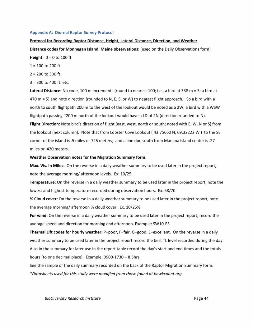
BioDiversity Research Institute Page 44
Appendix A: Diurnal Raptor Survey Protocol
Protocol for Recording Raptor Distance, Height, Lateral Distance, Direction, and Weather
Distance codes for Monhegan Island, Maine observations: (used on the Daily Observations form)
Height: 0 = 0 to 100 ft.
1 = 100 to 200 ft.
2 = 200 to 300 ft.
3 = 300 to 400 ft. etc.
Lateral Distance: No code, 100 m increments (round to nearest 100; i.e., a bird at 338 m = 3; a bird at
470 m = 5) and note direction (rounded to N, E, S, or W) to nearest flight approach. So a bird with a
north to south flightpath 200 m to the west of the lookout would be noted as a 2W; a bird with a WSW
flightpath passing ~200 m north of the lookout would have a LD of 2N (direction rounded to N).
Flight Direction: Note bird’s direction of flight (east, west, north or south; noted with E, W, N or S) from
the lookout (next column). Note that from Lobster Cove Lookout ( 43.75660 N, 69.32222 W ) to the SE
corner of the island is .5 miles or 725 meters; and a line due south from Manana Island center is .27
miles or 420 meters.
Weather Observation notes for the Migration Summary form:
Max. Vis. In Miles: On the reverse in a daily weather summary to be used later in the project report,
note the average morning/ afternoon levels. Ex: 10/25
Temperature: On the reverse in a daily weather summary to be used later in the project report, note the
lowest and highest temperature recorded during observation hours. Ex: 58/70
% Cloud cover: On the reverse in a daily weather summary to be used later in the project report, note
the average morning/ afternoon % cloud cover. Ex. 10/25%
For wind: On the reverse in a daily weather summary to be used later in the project report, record the
average speed and direction for morning and afternoon. Example: SW10-E3
Thermal Lift codes for hourly weather: P=poor, F=fair, G=good, E=excellent. On the reverse in a daily
weather summary to be used later in the project report record the best TL level recorded during the day.
Also in the summary for later use in the report table record the day’s start and end times and the totals
hours (to one decimal place). Example: 0900-1730 – 8.5hrs.
See the sample of the daily summary recorded on the back of the Raptor Migration Summary form.
*Datasheets used for this study were modified from those found at hawkcount.org
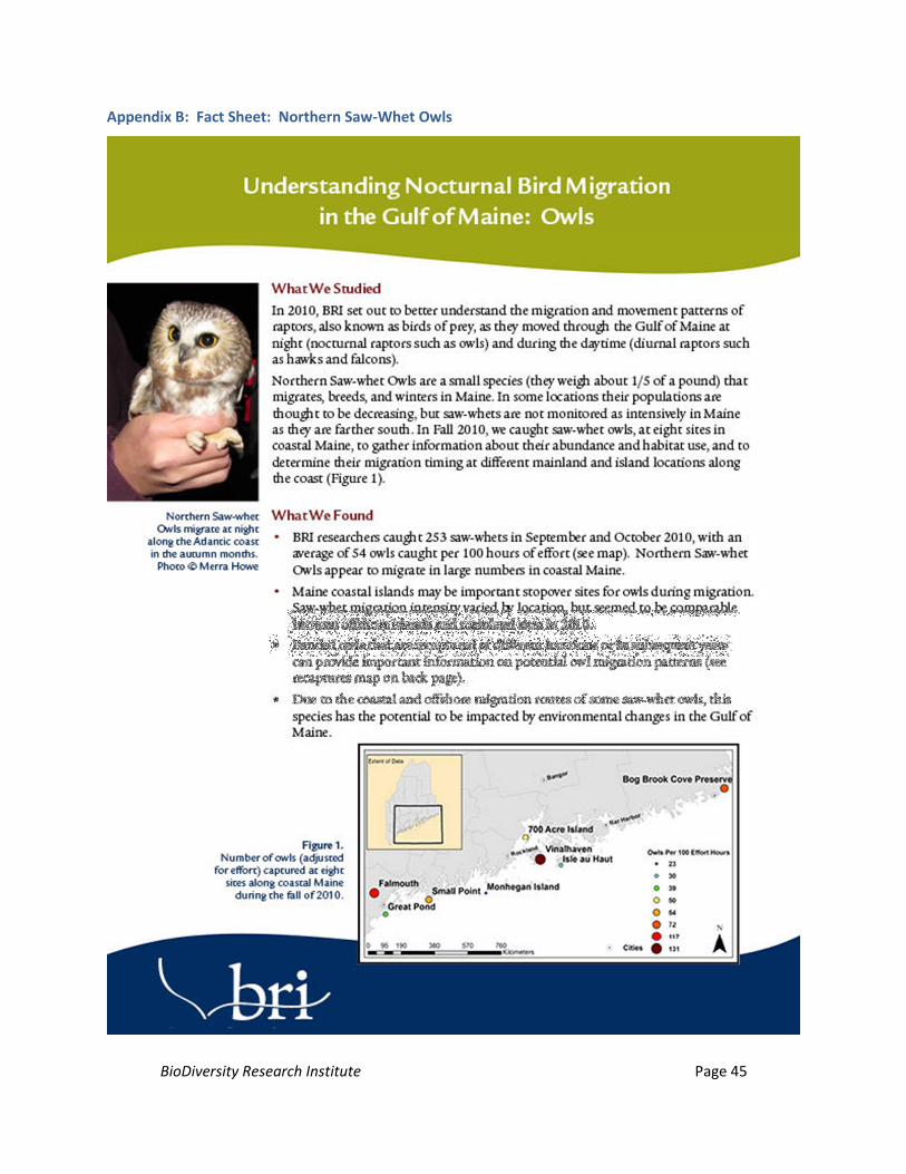
BioDiversity Research Institute Page 45
Appendix B: Fact Sheet: Northern Saw-Whet Owls
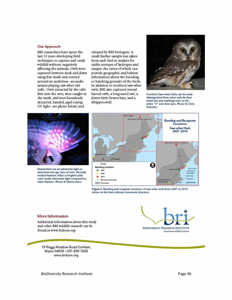
BioDiversity Research Institute Page 46
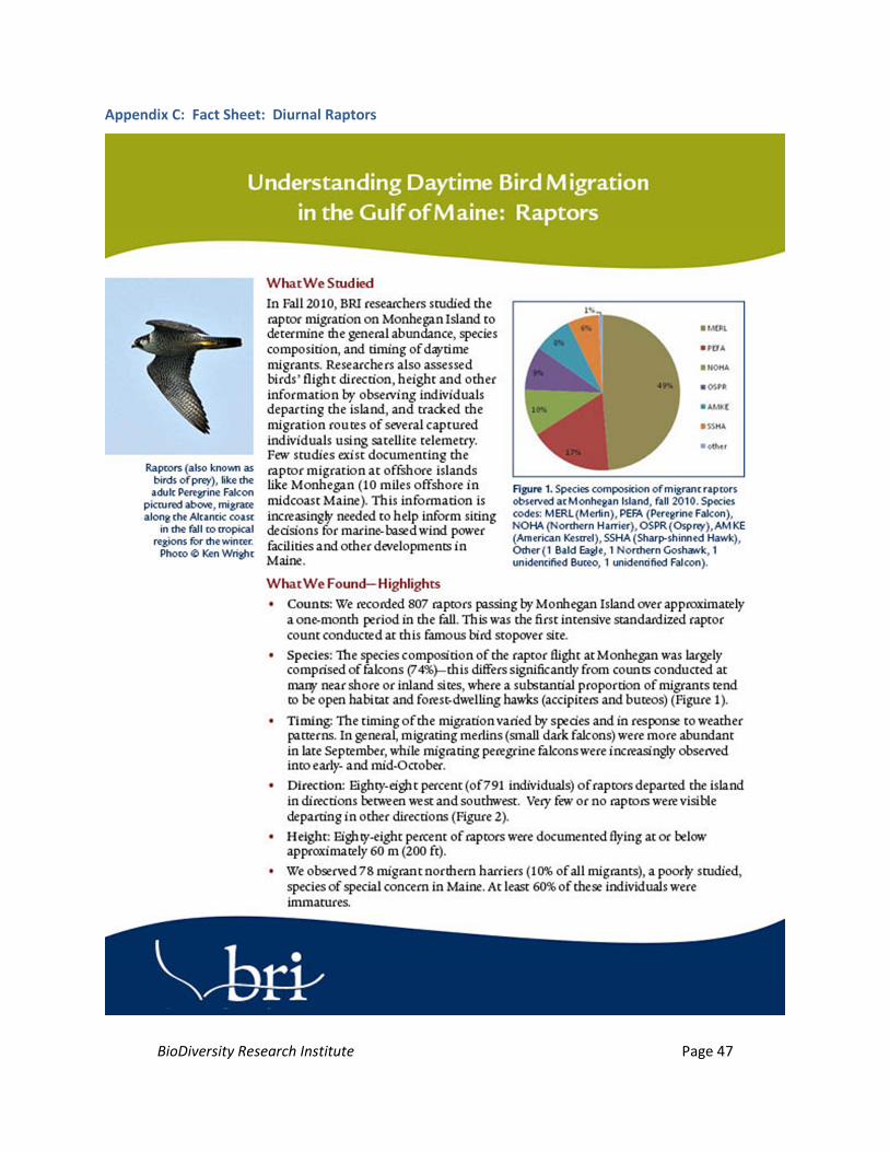
BioDiversity Research Institute Page 47
Appendix C: Fact Sheet: Diurnal Raptors
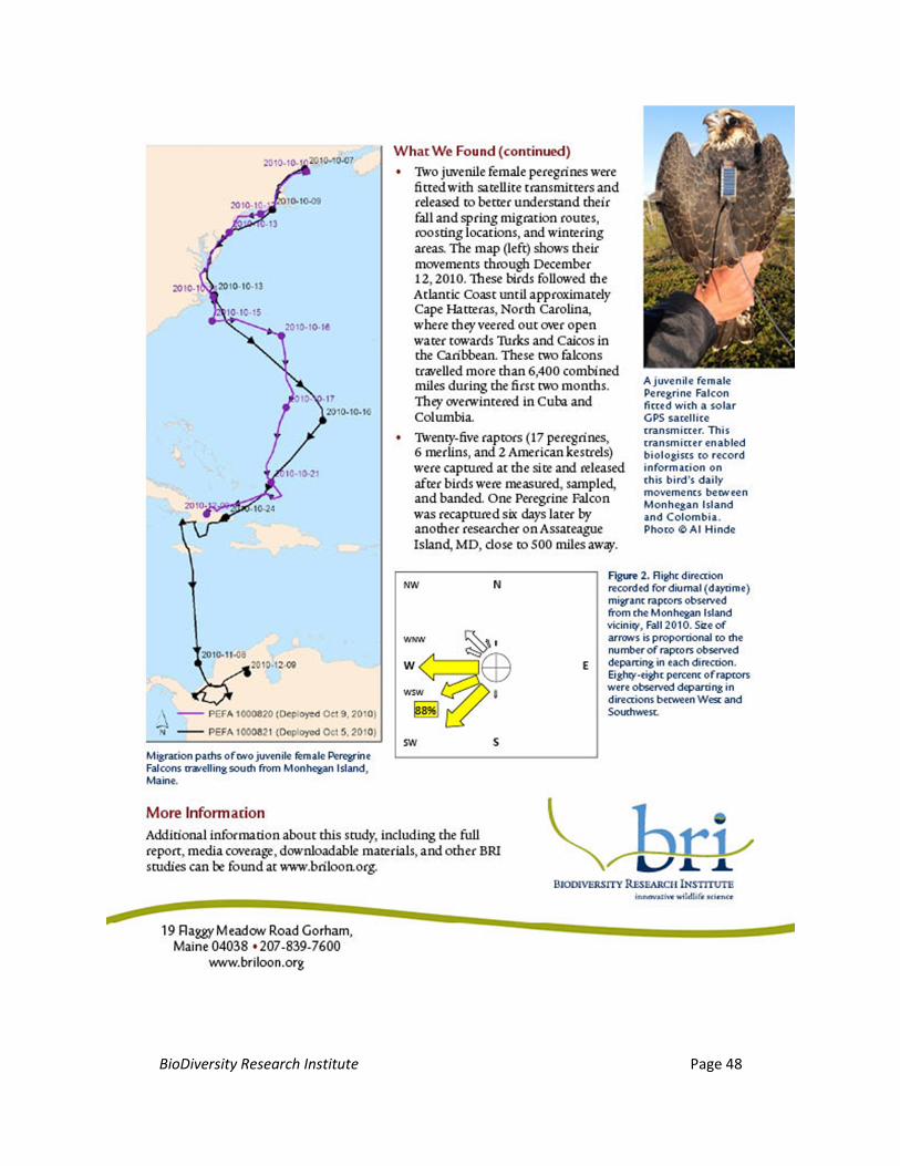
BioDiversity Research Institute Page 48


![Diurnal and Nocturnal Animals. Diurnal Animals Diurnal is a tricky word! Let’s all say that word together. Diurnal [dahy-ur-nl] A diurnal animal is an.](https://static.documents.pub/doc/80x56/56649dda5503460f94ad083f/diurnal-and-nocturnal-animals-diurnal-animals-diurnal-is-a-tricky-word-lets.jpg)


