20
Progress Report April 2009 Progress Report April 2009 S STINA RESOURCES LTD. S STINA RESOURCES LTD.

Progress ReportApril 2009Progress ReportApril 2009
SSTINARESOURCES LTD.
SSTINARESOURCES LTD.

Introduction2010 expects to be a very exciting and sucecssful year for Stina and it’s shareholders. All four of the Company’smineral properties will see significant exploration this year, and substantial results are expected, improvingCompany value and shareholder equity. Stina plans to conduct the first core driling on the Dime gold propertyin the Yukon in early summer as part of a substantial exploration program focussed on refining the formerTeck target located on the claim block, in addition to expanding the property’s future targets.
Stina will continue with further soil sampling and trenching on the two proposed target areas of the Kodiakgold property in the Yukon in an effort to establish future drilling targets. 2009 exploration confirmed manygeological consistancies with the neighbouring tie-on Underworld White Gold Property, and the Companyintends to further strengthen these similarities.
The Bisnoi McKay vanadium property in Nevada will see an aggressive core and RC drilling program, inaddition to further metallurgical research, aimed at moving the property towards pre-feasibility. In addition,the Company continues to explore future marketing opportunities for it’s vanadium resource, includingtraditional and newly emerging green technologies.
Exploration on the Zeibright gold Property in northern California has been initiated by sub-optionee TrimaxCorporation, who have very aggressive plans to continue development on the former Newmont gold producingmine. Stina has partnered with Trimax and expect them to rapdily develop the value of this property in 2010.
All of our shareholders are big part of Stina’s 2010 year, and will continue to be into the future as thecompany further explores and develops its gold properties in the upcoming seasons. Stina believes it hasexcellent properties, solid shareholder backing and resources, the ability to raise capital, emerging contacts,and the fortitude to become a significant player in the mineral exploration industry.
As a major shareholder, we thank you for your continued support and look forward to working with you aswe grow the company. Encompassed in this report is a snapshot summary of the company and its explorationproperties as of March 2010. Should you have any further questions, we would be pleased to meet with youat any time to discuss. In adition, our company website is www.stinaresources.com.
Sincerely,
Jim WallControllerStina Resources Ltd.

Directors and OfficersRod Sinn, President / CEO, Director, Toronto, ONSince: 2009 Mr. Sinn (48) brings an impressive record of diversified business success and a high level ofbusiness acumen to the company. His achievements include building a highly respected and profitable mortgagebrokerage firm, the reorganization and expansion of an international high tech company, as well as growinga security firm from 180 to 800 employees. He possesses the skill sets required to achieve the company’slong-term strategies and strategic partnerships while maximizing value for all shareholders.
Edward Gresko, Vice President, Toronto, ONSince: 1993 Mr. Gresko brings a great deal of experience and contacts to Stina, particularly in eastern Canadawith respect to corporate identity, investor relations and capital fundraising. Formerly a broker and salesperson,he has a strong background in public companies, particularly in the mineral exploration and resource industry.In addition, he provides strong sales management.
Sidney Mann, Treasurer / Director, London, EnglandSince: 1994 Mr. Mann, a chartered accountant in England, has over 25 years of experience with publiccompanies, both in North America and Europe. As chairman of the audit committee, Mr. Mann oversees thefinancial and operational infrastructures of the company. He has strong investor relations contacts throughoutEurope, particularly in capital fund raising.
James Corrigan, Director (April 2010), Vancouver, BCMr. Corrigan brings many years of investor relations and technology experience to Stina. He has worked asa consultant to Stina for over 5 years, and has ben instrumental in developing many key presentations for theCompany. Additionally, he brings strong investor communications skills and contacts to Stina.
Jim Wall, Secretary/ Controller, Director (April 2010), Vancouver, BCSince: 1995 Mr. Wall, a graduate of UBC in the fields of Commerce and Athletic Administration, has overtwelve years experience managing public companies. Acting as the financial controller for Stina, he overseesthe day to day operations of the company. He has a strong administrative background and brings solidorganizational and technical skills to the company.
Key ConsultantsEd Ulmer, P. Geologist, Denver, CODennis LaPrairie, P. Engineer, Reno, NVJean Pautler, P. Geologist, Whitehorse, YTShawn Ryan, Geo Consultant, Dawson City, YT
Corporate Information
Page 2
Head OfficeSte 717 – 165 LaRose AvenueEtobicoke, ON M9P 3S9Tel: (416) 368-2271Fax: (416) 368-2635E-Mail: [email protected]: www.stinaresources.comRegistrar and Transfer AgentOlympia Trust Company,Vancouver, BCSolicitorsFang & AssociatesVancouver, B.C.
AuditorsDale, Matheson, Carr-Hilton, Labonte, LLPChartered AccountantsVancouver, B.C.ListingTSX Venture ExchangeSymbol: SQADirect Contact InformationJim Wall; Tel. (604) 244-0964Tel. (800) 882-3213

Operations Detail and Financial Conditions
Selected Annual Financial Information
FISCAL YEARS ENDEDSeptember 30, 2009* September 30, 2008 September 30, 2007
Total Revenue $ 60,625* $ 65,437 $ 64,008Gross Profit $ 45,321* $ 44,426 $ 47,355Operating Expenses $ 278,634* $ 265,911 $ 234,937Net Income (Loss) $ (323,955)* $ (221,485) $ (184,628)Loss Per Share $ (0.02) $ (0.02) $ (0.02)Total Assets $ 5,833,188 $ 3,563,114 $ 1,527,196
Summary of Quarterly Results
QUARTERS ENDEDDec. 31, 2009* Sept. 30, 2009* June 30, 2009 Mar. 31, 2009
Total Revenue $ - $ 10,321 $ 17,019 $ 20,594Gross Profit $ - $ 7,272 $ 11,867 $ 17,338Oper. Expenses $ 265,836 $ 94,105 $ 60,060 $ 140,216Net Income (Loss) $ (265,836) $ (132,154) $ (48,193) $ (122,878)(Loss) Per Share $ (0.01) $ (0.02) $ (0.003) $ (0.008)Total Assets $ 5,777,771 $ 5,833,188 $ 3,597,803 $ 3,610,155Total Liabilities $ 159,925 $ 158,201 $ 179,337 $143,496
QUARTERS ENDEDDec. 31, 2008 Sept. 30, 2008 June 30, 2008 Mar. 31, 2008
Total Revenue $ 12,691 $ 15,727 $14,066 $ 18,467Gross Profit $ 8,844 $ 9,402 $ 10,196 $ 13,209Oper. Expenses $ 29,574 $ 61,976 $ 64,623 $ 84,855Net Income (Loss) $ (20,730) $ (52,574) $ (54,427) $ (71,646)(Loss) Per Share $ (0.001) $ (0.004) $ (0.005) $ (0.006)Total Assets $ 3,624,125 $ 3,563,114 $ 4,109,022 $ 1,389,469Total Liabilities $ 148,872 $ 131,631 $ 100,845 $ 122,465
*On September 30, 2009, the Company discontinued its Northern Seas Health Foods Division. Operating details of thisdiscontinued division were consolidated into Loss from Discontinued Operations on the company financial statements soas to comply with future IFRS requirements regarding comparative figures.
Page 3

Comparative Mineral Property Exploration
Three Months Year EndedEnded Dec. 31, Sept. 30,
2009 2009Bisoni McKay Vanadium Property, Nevada, USA
Acquisition costsBalance, beginning of year $ 2,846,585 $ 2,858,617
Incurred during the year:Staking and claim costs 2,466 9,736Reclassify reclamation bond posted on property - (21,768)Balance, end of year 2,849,051 2,846,585
Exploration expendituresBalance, beginning of year $ 695,568 $ 650,511Incurred during the year:Geological consulting - 194Permits and bonds 194 -Reclamation estimate - 21,768Storage 1,935 8,642Balance, end of year 698,983 695,568
Total Bisoni McKay Property 3,548,034 3,542,153
Kodiak Property, Yukon Territory, Canada
Acquisition costsBalance, beginning of year $ 184,675 $ -Incurred during the year: Acquisition costs, cash - 75,000Acquisition costs, 250,000 shares at $0.44 - 1009,675Balance, end of year 184,675 184,675
Exploration expendituresBalance, beginning of year $ 146,729 $ -Geological consulting 750 74,217Geomagnetic - 10,938Helicopters - 14,595Soil sampling - 46,979Balance, end of year 147,479 146,729
Total Kodiak Property $ 332,154 $331,404
DimeProperty, Yukon Territory, Canada
Exploration expendituresBalance, beginning of year $ 91,901 $ -Geological consulting - 91,901
Total Dime Property $ 91,901 $91,901
Cumulative Mineral Interest Expenditures* $ 3,972,512 $ 3,965,458
*includes $423 expensed in claim costs on Zeibright Property in California, USA in quarter ending Dec. 31, 2009
Page 4

Flow through ExpendituresA total of $1,000,000 in flow-through expenditures have been committed by the Company before December 31, 2010. Todate $68,400 was expensed in August 2009, and $79,373 in September, towards the Kodiak and Dime Gold Propertieslocated in the Yukon.
Liquidity and SolvencyDuring the period ended December 31, 2009 over the same period in 2008, cash resources (including short-terminvestments) increased by $1,709,403. As at December 31, 2009 the Company had a working capital surplus of $1,623,566(December 31, 2008 – deficiency of $40,900).
Current Capital StructureTotal Shares Issued & Outstanding: 20,458,643Fully Diluted: 22,982,656Estimated Float: 9,000,000Escrow: 281,250
Employee Options:887,475 @ $0.21, expiring May 18, 2010; 675,000 @ $0.30, expiring Nov 13, 2014
Warrants:961,538 share purchase warrants, expiring Jul 10, 2011 @ $1.00 in year one, $1.25 in year two
Cash: $1.5M – March 2010
Summary of Securities Three Months Ended Year ended
December 31, 2009 September 30, 2009Number of Amount Number of Amount
Shares $ Shares $
Balance, beginning of year 20,458,643 9,327,410 14,624,067 6,806,435Issued during the year:Cash, stock option @ $0.21 10,000 2,100 - -Cash, private placement- at $0.20 i) - - 661,500 132,300- at $0.47 ii) - - 3,000,000 1,410,000- at $0.52 iii) - - 1,923,076 1,000,000Share issue costs - (131,000Mineral property:- at $0.44 iv) 250,000 125,000 - -Transfer - contributed surplus v) - 2,850 - -
Balance, end of year 20,458,643 9,332,360 20,458,643 9,327,410
i) On January 16, 2009, the Company completed a non-brokered private placement of 661,500 shares at $0.20 per share.
ii) On July 10, 2009, the Company completed a non-brokered private placement of 3,000,000 shares at $0.47 per share.
iii) On July 10, 2009, the Company completed a non-brokered private placement of 1,923,076 share units at $0.52 per unit. Eachunit consists of one common share and one half share purchase warrant. Each full warrant entitles the holder to acquire oneadditional common share at $1.00 per share up to July 11, 2010 or $1.25 per share until July 11, 2011.Finders’ fees of $131,000in cash were paid in connection with the above private placement.
iv) On July 8, 2009, the Company issued 250,000 common shares, at $0.50 per share as part of a property acquisition valued at$125,000.
v) The Company records the grant date fair value of vested stock options as a credit to contributed surplus. These amounts aretransferred to share capital upon exercise of the underlying stock options. During the period, $2,850 was transferred to sharecapital for options exercised.
Page 5

Shares in Escrow
As at March 31, 2010, 281,250 shares were held in escrow. The shares are subject to a time release escrowagreement as follows:
Anticipated release dates: Shares for releaseJune 24, 2010 93,750December 24, 2010 93,750June 24, 2011 93,750Total 281,250
Stina Mineral Exploration
Kodiak Gold Property
BackgroundLocated approximately 150 km south of Dawson City, YT, the Kodiak Property claim block consists of 152claims covering 30 square kilometres, or 6,400 acres, and ties on to the southern side of Underworld Whitegold property. The Kodiak claim block also straddles Thistle Creek, which was the richest placer gold-producing creek in the area, given up more than 63,000 ounces of placer gold since the turn of the century.
Shawn Ryan of Ryanwood Exploration Inc. (REI) was the vendor for the Kodiak property, as well as forUnderworld’s White property, and re-evaluated the Geological Survey of Canada database for similar positiveindicators for white-style mineralization on the Kodiak property. The GSC silt survey of the Thistle areaidentified anomalous gold and arsenic levels in silt samples collected from streams that drain Kodiak property.The presence of elevated gold and arsenic values suggests potential for mineralization similar to that identifiedby Underworld Resources.
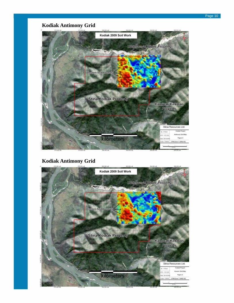
2009 Work ProgramIn August the Company initiated a work program on the Kodiak property. A total of 1,925 soil samples werecollected on a grid covering 875 hectares or 2,163 acres, about 28 per cent of the Kodiak claim block. Thesamples were collected at 50-metre intervals along north-south lines 100 metres apart. All samples wereanalyzed by multielement scan at ACME labs of Vancouver. The soil survey is an important explorationtool at the Kodiak property because rock outcrops are scarce and it identified two anomalous areas ofinterest on the grid.
With background gold of 2.5 parts per billion (ppb) over the sample grid, a large contiguous area on thewestern side of the grid carries greater than four parts per billion gold with accompanying elevated valuesof arsenic and antimony. This anomalous area is 2,000 metres long and from 100 metres to 750 metres wide.Within this broad area, a cluster of higher gold grades range from 14 ppb to 99 ppb with arsenic from 40 to676 parts per million and antimony from one part per million to 6.9 ppm. Another cluster of samples locatedjust outside of the elevated gold area carries gold values ranging from 140 ppb to 308 ppb. This anomaly isunique in that there are no elevated arsenic values. Each of these higher-grade clusters covers an area of 250by 250 metres.
On the eastern side of the grid there is a group of more isolated pockets of elevated gold values also withaccompanying arsenic and antimony. Elevated nickel values in soil also occur either with or in the proximityof the anomalous gold zones indicating underlying mafic or ultramafic rocks. Airborne and ground magneticsurveys also support the presence of these rocks on the Kodiak property as well as their existence about 15kilometres north on the Underworld White gold property.
Page 6

Page 7

In addition to the gold anomalies found, the soil survey results are significant for the element associations,the pattern of their distribution and for revealing geologic similarities on the Kodiak property with theUnderworld White gold deposits located about 15 km north.These include the following:
• Arsenic and antimony are common associated elements with gold mineralization.
• The anomalies form three northwest linear trends suggesting a structure control of mineralization on theKodiak claims.
• On the Underworld’s Arc gold deposit, gold is accompanied by arsenic. Underworld’s Golden Saddledeposit contains no arsenic. The contrasting arsenic contents are also evident in the anomalies on theKodiak grid.
• The Kodiak anomalies are at the end of a high magnetic trend that extends from the Underworld Whiteproperty.
• The soil anomalies at Kodiak are on or between magnetic anomalies that are interpreted as mafic rocks.The elevated nickel values also support this. Similarly, the higher-grade gold mineralization atUnderworld’s Golden Saddle deposit sets next to ultramafic units with strong magnetic signatures.
• The potential for gold mineralization on the Kodiak block is further supported by historical placer goldproduction on Thistle Creek that bounds the north side of the claim block, and the anomalous silt (stream)sediment values on Kodiak from GSC surveys.
A 43-101 geo-technical report on the Kodiak property has been received from Jean Pautler.
Report Recommendations:Based on the favorable geological setting, geology, magnetic geophysical signature, gold in soil anomaliesand similarities and proximity to the White Gold discovery of Underworld Resources Ltd., further work isrecommended on the Kodiak Project. A 5 line km trenching program is recommended to test the anomalousgold in soil geochemistry. Possible initial trench locations are shown in Figure 6 of the report, but requirefield ground truthing for confirmation of suitable locations, and additional trench targets may be indicated bythe additional soil geochemistry recommended below. Two additional soil grids are recommended, a 2500mby 2500m grid (Northwest Grid), consisting of 1,300 soils, to the west of the 2009 grid and a 2500m by1500m grid (Southeast Grid), consisting of 780 soils, to the south of the 2009 grid. The grids are designed tocover the regional northwest structure, mapped by the Geological 25 Survey of Canada, just southwest of thewestern gold in soil anomaly from the 2009 grid (Northeast Grid) due to evidence of a possible northweststructural control. Ridge and spur soil geochemistry is also recommended over the remainder of the propertyin order to evaluate it. Property scale mapping, prospecting and rock geochemical sampling should also beconducted at this time. This should be followed up with a Phase 2 diamond drilling program with a smallhelicopter supported rig to test the gold in soil anomalies. Drill targets currently exist based on the soilgeochemistry but can be prioritized based on the results of the grid soil and trenching program. Based on theabove recommendations, the following two phase exploration program with corresponding budget is proposed.
2010 ExplorationThe company plans to expand the western side of the 2009 soil sample grid with an additional 3,000 soilsattempting to refine a drilling target.
In the fall of 2009 a total of 1,925 soil samples were collected on a grid covering 875 hectares or 2,163 acres,about 28 per cent of the Kodiak claim block. This anomalous area is 2,000 metres long and from 100 metresto 750 metres wide Within this area, a cluster of higher gold grades range from 14 ppb to 99 ppb with arsenicfrom 40 to 676 parts per million and antimony from one part per million to 6.9 ppm. Another cluster ofsamples located just outside of the elevated gold area carries gold values ranging from 140 ppb to 308 ppb.This anomaly is unique in that there are no elevated arsenic values. Each of these higher-grade clusterscovers an area of 250 by 250 metres.
Page 8

Kodiak - White Regional Claims
Page 9
Kodiak Antimony Grid
Kodiak Antimony Grid
Page 10

Kodiak 2010 Exploration Budget
Expected start time: late May 2010
Program3,000 soils @$50 per inclusive of collection transport and assay $150,00020 days of trenching @ $1,000 per day all inclusive 20,00010 days pf geology work @ $750 per day 7,500Contingency including helicopter, rock assay 20,000
Total Estimated Budget $197,500
Future Kodiak Property Commitments to Vendor (REI):
Pay to Ryanwood:- $50,000 on or before June 15, 2010;- $100,000 on or before June 15, 2011;- $75,000 on or before June 15, 2012;- $75,000 on or before June 15, 2013.
Issue and deliver to Ryanwood:- 200,000 common shares of the company on or before June 15, 2010;- 200,000 common shares of the company on or before June 15, 2011;- 200,000 common shares of the company on or before June 15, 2012;- 200,000 common shares of the company on or before June 15, 2013.
Incur expenditures:- In the amount of $100,000 on or before Nov. 18, 2009 (deferred on advance made to REI)- In the additional amount of $200,000 on or before Nov. 15, 2010;- In the additional amount of $300,000 on or before Nov. 15, 2011;- In the additional amount of $500,000 on or before Nov. 15, 2012.
Dime Gold Property
BackgroundDime Property consisting of 128 mineral claims (2,655 hectares) is located in the Ten Mile Creek areaapproximately 75 kilometers south of Dawson City in the Yukon Territory. The area south of Dawson Cityhas become a focus for gold exploration as a result of recent announcements by Underworld Resources thatdrilling has intersected wide intervals of intrusion related gold mineralization at their White Gold Property.Underworld Resources website lists recent drill holes ranging from 104.0 meters averaging 3.89 g/t gold(WD09-31) to 31.1 meters averaging 9.20 g/t gold (WD 09-47).
The property contains part of a former Teck drilling target over the southwest corner of the property.
2009 ExplorationIn August the Company contracted Carl von Einsiedel of RAM Explorations to make an initial fieldexamination of the Dime property and present Stina with a 43-101 technical report. During the propertyexamination it was determined that the location of the claim posts for the adjoining mineral claims in the TenGrid area are incorrectly located on the Yukon Department of Mines claim maps. claim posts in the field willbe used to determine the boundary of the Dime Property and that the Dime Property will be reduced. Based
Page 11

on the assumption that the southwestern boundary of the present Dime Property will be adjusted to reflectthe actual location of the adjoining mineral claims the southwestern boundary of the Dime Property currentlyshown on the Yukon Department of Mines website has been moved approximately 135 meters to the northeast.
A 43-101 geo-technical report on the Kodiak property has been received from Carl von Einseidl
Report Recommendations:To further evaluate the Dime Property it is recommended that the Company complete a Stage 1 ExplorationProgram consisting of a detailed geochemical survey of the Ten Grid Area (50 meter spaced grid lines) anda more widely spaced geochemical survey (either along 100 – 200 meter spaced lines or along topographiccontour profiles) that extends from the eastern part of the Ten Grid Target to the eastern and southeasternboundaries of the Dime Claims (referred to as the Dime Property Recon Grid). Additionally, the Companywill complete a land survey to accurately establish a cut line that marks the legal boundary between the DimeClaims and the remaining valid Teck Claims in the Ten Grid Area.
For the Ten Grid Detail Area the survey area is estimated at 0.9 square kilometers. Using a sample density of800 samples per square kilometer (equivalent to 25 meter spaced samples along 50 meter spaced lines) andtaking into account the samples collected during the present evaluation a total of approximately 500 additionalsoil samples will be required to define specific target area for follow-up trenching. On completion of the soilsampling program excavator trenching, systematic rock sampling, geological mapping and ground magneticsurveys should be completed within the presently defined limits of the Ten Grid Target Area.
For the Dime Property Recon Area the survey area is estimated at 8.4 square kilometers. Using a sampledensity of 200 samples per square kilometer (equivalent to 50 meter spaced sampling along 100 meterspaced lines) a minimum of 1,680 samples will be required to assess the Dime Property Recon Area. In theevent that significant targets are identified within the Dime Property Recon Area allowance should be madefor completion of at least two detail survey grids comprising a minimum of 250 samples. The estimated costof the program is $259,710 and should provide sufficient geological information to determine if a follow-updrill program is warranted. The most cost effective way to complete the proposed program will be to constructa temporary tent camp to accommodate sampling, trenching and geological personnel in the northern part ofthe Ten Grid area. Alternatively, Stina could complete the proposed sampling program from a nearby basecamp and ferry personnel back and forth on a daily basis provided that cost sharing agreements are in placeto minimize helicopter charter requirements.
In the event that the Stage 1 program defines a significant mineralized zone a second stage program consistingof helicopter supported diamond drilling would be warranted. The cost of a follow up drill program based onthe assumption that two target areas will be tested by a maximum of 1,000 meters of diamond drilling isestimated at approximately $350,000.
2010 ExplorationThe company plans to expand the present southwest grid soil sampled in late 2009, directed towards refininga drilling target. Additional exploration includes trenching to bedrock, ground geophysics. Sampling willdetail and expand the present grid and continue further exploration in areas of interest elsewhere on the claimblock. Due to proximity of the southwest target grid on the claim boundary, the company is currently dis-cussing joint exploration over the target with Solomon Resources who hold the adjacent property claims.The 2009 soil sample program included 191 soil samples (plus 10 duplicates) collected on a grid coveringabout 37 hectres. The gold values in the survey range from one part per billion to 6,082 ppb, or six ppmwith a trend on the bottom claims of the property. (See news release dated February 8, 2010)
Page 12

Page 13

Dime 2010 Exploration Budget
Expected start time: late May/ early June 2010
Budget3,000 soils @$50 per inclusive of collection transport and assay $150,000140 days of trenching @ $1,000 per day all inclusive 140,000Trenching equipment mobilization 5,000Geology work 20,000150 km of ground magnetic survey @$125 per 18,7505 diamond drill holes of 100 m each @ $500 inclusive 250,000Contingency fund 18,750
Total $602,500
Future Property Commitments to Vendor (REI)
Pay to Ryanwood:- $125,000 on or before June 26, 2010;-$100,000 on or before June 26, 2011;-$100,000 on or before June 26, 2012;- $150,000 on or before June 26, 2013.
Issue and deliver to Ryanwood Exploration:- 200,000 common shares of the company on or before June 26, 2010;- 300,000 common shares of the company on or before June 26, 2011;- 300,000 common shares of the company on or before June 26, 2012;- 250,000 common shares of the company on or before June 26, 2013.
Incur expenditures:- In the amount of $100,000 on or before Nov. 15, 2009 (deferred);- In the additional amount of $250,000 on or before Nov. 15, 2010;- In the additional amount of $500,000 on or before Nov. 15, 2011;- In the additional amount of $750,000 on or before Nov. 15, 2012.
Bisoni McKay Vanadium Property
BackgroundStina’s 309 hectare, 37 claim Bisoni McKay Vanadium property in northern Nevada, about 50 km southeastof Eureka, NV is currently partway into phase II of development. The property sits in the vanadium beltadjacent to the Bisoni and Gibillini vanadium properties, the latter currently being developed by RockyMountain Resources.
In 2005 Stina completed Phase I of an introductory drilling program, which included the first diamonddrilling on the property ever. Results were very strong, including:75 ft of 0.95% V2O5 contained within 320 ft of 0.46% V2O5, in DDH-BMK-05-01.
• 76 ft of 0.95% V2O5 contained within 320 ft of 0.46% V2O5, in DDH-BMK-05-01.• 131 ft of 0.88% V2O5 contained within 345 ft of 0.53% V2O5 in DDH-BMK-05-02.• 115 ft of 0.60 V2O5 in DDH-BMK-05-03.• 300 ft of 0.45% V2O5 in RC BMK-05-01.• 120 ft of 0.55% V2O5 and 170 feet of 0.47% V2O5 in RC BMK-05-02.• 120 ft of 0.55% V2O5 in RC BMK-05-03.
Page 14

In 2005 the Company identified three sections on the 2,000 foot strike length.Northern Section A is a well defined ore body stratabound and strataform in carbonaceous shale, extendingto the south open to the north, approximately 600 feet wide and 600+ feet deep, dipping 85 degreed to thesoutheast. Phase II interval RC drilling and a subsequent 43-101 resource estimate conducted on a 700square foot grid located in Northern Section A in 2008 showed 10.6M indicated short tons of vanadiumpentoxide at 0.39% at a 0.2% cutoff grade, and an additional 9M inferred short tons of vanadium pentoxideat a 0.2% cutoff grade.Engineers estimate a much higher tonnage on Northern Section A.
Highlights of the Northern Section A grid RC drilling over a sub section 100 wide X 700 feet included:• Inclusive section of 350 ft of 0.47% V2O5 on hole RC BMK 07-03• Inclusive section of 220 ft of 0.40% V2O5 on hole RC BMK 07-04.• Inclusive section of 120 ft of 0.47% V2O5 on hole RC BMK 07-05.• Inclusive section of 270 ft of 0.38% V2O5 on hole RC BMK 07-06.• Inclusive section of 235 ft of 0.38% V2O5 on hole RC BMK 07-07.• Inclusive section of 240 ft of 0.47% V2O5 on hole RC BMK 07-08.• Inclusive section of 170 ft of 0.44% V2O5 on hole RC BMK 07-09.• Inclusive section of 200 ft of 0.57% V2O5 on hole RC BMK 07-10.An NI 43-101-compliant mineral resource study, completed in November, 2007, by Maptek using the Vulcanprogram, determined indicated resources in the north half of Area A totaling 8.07 million short tonsaveraging 0.43 per cent V2O5 at the 0.3 per cent grade cut-off zone and 10.6 million short tons averaging0.39 per cent V2O5 at the 0.2 per cent cut-off.
The indicated resources calculations table separates reduced and oxide mineralization. About 130 feet to 150feet of oxidized shale overlies the carbonaceous mineralization, the result of deep weathering of the carbon-aceous-shale host rock. The transition from oxidized to reduced zone is typically abrupt, and in some holesthere is supergene vanadium enrichment of vanadium from five feet to 35 feet below the redox horizon withgrades that can be 50 per cent to 150 per cent higher than grades in the reduced shale below. Because ofgeological evidence and good grade and mineralization continuity in Area A-North, an inferred resourceestimate was calculated Area A-South using data from three 2005 RC holes, BMK 05-1, 2 and 3 at intervalsslightly more than 200 feet apart.
Metallurgical testing at Hazen Research in Golden, CO in 2007 on Northern Section A ore, resulted in over90% recovery of vanadium pentoxide in oxidized material using an acid pug leach method, and almost 70%V2O5 recovery on carbonaceous material using a roast operation.
Southern Section B has shown very good RC drilling results twinning strong Hecla RC holes drilled in the1970s. Section B is less defined and surrounded by more limestone than section A.Further south is Section C, containing historical drilling from the 1950s to the 1970s by many organizationsincluding Union Carbide and Noranda. This section is considered the wildcard section on the Bisoni McKayproperty with strong potential, yet unexplored.
Bisoni McKay Property Highlights:• Only known pure-vanadium operation in North America• NI 43-101 qualified with initial mineral resource study completed• Easy logistical access• Located in mining-friendly Nevada• Open-pittable - mineralization close to surface• Host rock is soft and very easy to grind• Potentially leachable operation• High levels of tonnage and grade
2010 ExplorationThe Company intends to refine and complete the Phase II program initiated in 2007. The Company proposesdrilling an additional 18 reverse circulation holes for a total of 7,000 feet and 8 core holes for a total of4,000 feet. This Northern Section B drilling would continue directly south of core fence BMK - 01, 02 and03 drilled in 2005 in 100 foot stepouts and additional fences. The result would be an expanded drill areaof approximately 1,500 feet in length by 100 to 200 feet in width, on which the 2008 resource estimatecould be updated.
Page 15

Page 16

The Company also intends to further metallurgical testing on oxidized, transition and carbonaceous materialfrom Northern Section A at Hazen Research expanding on previously reported strong recovery results. Ascoping study is being considered, and the Company intends to discuss the possibility of an initial pilot plantwith the Nevada Bureau of Land Management. Drilling could commence in May, and metallurgical testingand resource updates could be made in the fall of 2010.The estimated budget for the 2010 Bisoni McKay Program is between $500,000 and $750,000.
Future Property CommitmentsNone
Bisoni McKay Property Resource Estimate
Page 17
Zeibright Gold Property
BackgroundThe Zeibright mine is a former gold producer located in northeastern California, approximately 75 mileswest of Reno, NV along the border between Placer and Nevada counties in the Sierra Nevada mountainrange, and is within the Sierra Nevada gold-bearing area, immediately east of the productive Grass Valleyand Nevada City gold districts. The area is considered related to the motherlode structure, the northern limitof which is approximately 40 kilometres (25 miles) to the south-southwest of the Zeibright mine.
The Zeibright mine produced over 100,000 ounces of gold from underground operations until the 1950s.The Zeibright mineralized dike structure containing gold-bearing quartz veins ranges in width from 2.5metres (8.5 feet) to over nine m (30 feet). The structure, believed to be continuous, is exposed on either sideof the mountain and has been mined by various owners, between 1867 and 1959, including the NewmontMining Corp., which was in the process of tunnelling from two adits (north and south), through the northside of the mountain intending to connect to the Omega mine approximately 6,000 m (18,000 feet) farther.

The adit had been tunnelled approximately 600 m (1,800 feet) to the east from the Omega hydraulic pit tointersect the structure and a total of 2,600 m (8,500 feet) to the north from the existing Zeibright mineworkings. Approximately 2,300 m (7,000 feet) remain to link the two tunnels, and the north face of the adit(Zeibright side) was apparently left in ore.
Sampling results from Newmont Mining maps indicated ore-grade material in several locations along theadit that had not yet been developed. Historic Newmont sampling of the adit 1 tunnel over 385 m (1,266 feet)along a mean vein system width of 2.6 m (8.5 feet) averaged five grams/tonne (0.15 ounce/ton). A technicalreport was prepared for Stina in 2004 on the Zeibright Property by Elaine Basa, P.Geo. Stina acquired a100% interest in the Zeibright Property from Steephollow Resources Inc. of Reno, NV in March 2009. Theoption agreement calls for a minimum of $100,000 in exploration work before March 18, 2011, and issue toSteephollow Resources Inc. 1 million common shares of stock subsequent to this work being completed.
Sub-Option AgreementIn November 2009, Stina Sub-optioned the Zeibright Property to Trimax Corporation of Toronto, ON, apublicly trading company on the OTC Pink Sheets. Terms of the agreement call for Trimax to earn a 70%interest in the Property from Stina by completing $2 million US in exploration work over a period of fouryears as follows:
• $200,000 on exploration and development of the claims by July. 18, 2010• $300,000 on exploration and development of the claims by Feb. 18, 2011• $500,000 on exploration and development of the claims by Feb. 18, 2012• $1-million on exploration and development of the claims by Feb. 18, 2013
Stina maintains the right to buy back a 20-per-cent interest in the property for the payment of $500,000within 90 days after Trimax has exercised its option. The claims are subject to a 2-per-cent net smelterroyalty in favour of Dennis La Prairie as further described in the original Feb. 18, 2009 agreement betweenStina and Steephollow. The NSR may be bought back for $1-million for each 1-per-cent. Stina and Trimaxshall both have the right to buy such 1 per cent NSR proportional to their respective percentage holdings inthe property as at the date of receipt by Mr. La Prairie of the written notice to purchase such NSR interest.
2010 ExplorationThe company originally intended to conduct electromagnetic and geophysical studies on the top of thestructure above the tunnelling, attempting to interpolate mineralized vein continuity between the two tunnels.Additionally, the company intends to drill above the Zeibright structure adits to determine if mineralizationrises above this level. Trimax has obtained a copy of the 2004 Basa report and intends to explore the Zeibrightproperty along the same guidelines as Stina had intended.
Future Property Commitments to Vendor (Steephollow Resources Inc.)
Incur expenditures:- In the amount of $100,000 on or before February 18, 2011(expected to be completed by July 18, 2010 by Trimax Corp.)
Page 18

Recent News Release & Material ChangesOn April 5, 2010 the Company announced its exploration plans for the spring and summer of 2010 on itsDime and Kodiak gold properties in the Yukon Territory, as well as its Bisoni McKay vanadium property inNevada. A budget of $800,000 has been allocated to Dime and Kodiak, and approximately $500,000 toBisoni McKay. Preparations for these programs are under way, including geological evaluations of progressand results to date, establishment of sampling and drilling targets, and securing geological field staff andequipment. (see news release dated April 5, 2010)
On February 8, 2010 the Company announced results of a soil sample program on the Dime property. The2009 soil sample program included 191 soil samples collected on a grid covering about 37 hectares. The goldvalues in the survey were as high as 6,082 ppb, or six ppm along a mineralized trend on the bottom claims ofthe property. (see news release dated Feb 8, 2010)
On January 29, 2010 the TSX Venture Exchange accepted for filing the property option agreement datedJuly 23, 2009, between Ryanwood Exploration Inc. and Stina Resources Ltd. Stina has acquired the option toearn a 100-per-cent interest subject to a 2-per-cent net smelter return royalty, in the Dime property located inthe Dawson mining district, Yukon territory. To earn its interest the company must pay $600,000 and issue1.25 million shares over four years. The company must also spend $1.6-million on exploration of the propertyover four years. (see Dime property) The Company also issued 200,000 common shares of stock to RyanwoodExplorations Inc. The company can purchase half of the net smelter return royalty for $2-million.
On November 11, 2009 the Company announced the results of the soil sampling program completed inAugust 2009 on the Kodiak Property. 1,925 samples were collected on 50 metre intervals along north southlines of 100 metres each. The sampling covered approximately 28 percent of the Kodiak property and resultsidentified two anomalous areas of interest on the grid.
Changes in Accounting Policies including Initial Adoption of IFRSCanadian Companies are required by 2010 to make the transition from Canadian GAAP Reporting Standardsto International Financial Reporting Standards (IFRS). Stina has taken preliminary steps in this transition,including addressing financial statement presentation, disclosure procedures and providing risk assessmentevaluation prepared by management. The 2010/2011 fiscal year will be the first year fully reporting underIFRS standards.
At the conclusion of year end (September 30, 2009, Stina closed its health foods division (Northern Seas),intending to focus entirely on mineral exploration. The elimination of this division will eliminate not onlyoverhead costs in a declining market place, but also allow for clearer financial presentations.
Stina has recently established a subsidiary in the State of Nevada under the incorporation name Stina ResourcesUSA Ltd. as a division to hold the company’s US claims, in particular the Bisoni McKay Nevada Claims.
Subsequent Events and Looking ForwardStina has outlined intended exploration work on the Kodiak, Dime and Bisoni McKay properties in earlyspring with further soil samples and related geological and geo-chemical exploration work in key locations,with the purpose to establish reasonable drill targets in 2010. (see News Release Dated April 5, 2010)
Stina has also initiated discussions with several groups in the green technology large battery industries aboutsupplying vanadium from the Bisoni McKay vanadium property, and continues to follow these leads in anattempt to establish a pre-production market for vanadium pentoxide.
Stina intends to extend the sub-option agreement with Trimax Corp. threshold for the first $200,000 ofexpenditures from April 18, 2010 to July 18, 2010. All other details of the sub-option agreement remain thesame.
Page 19


