65
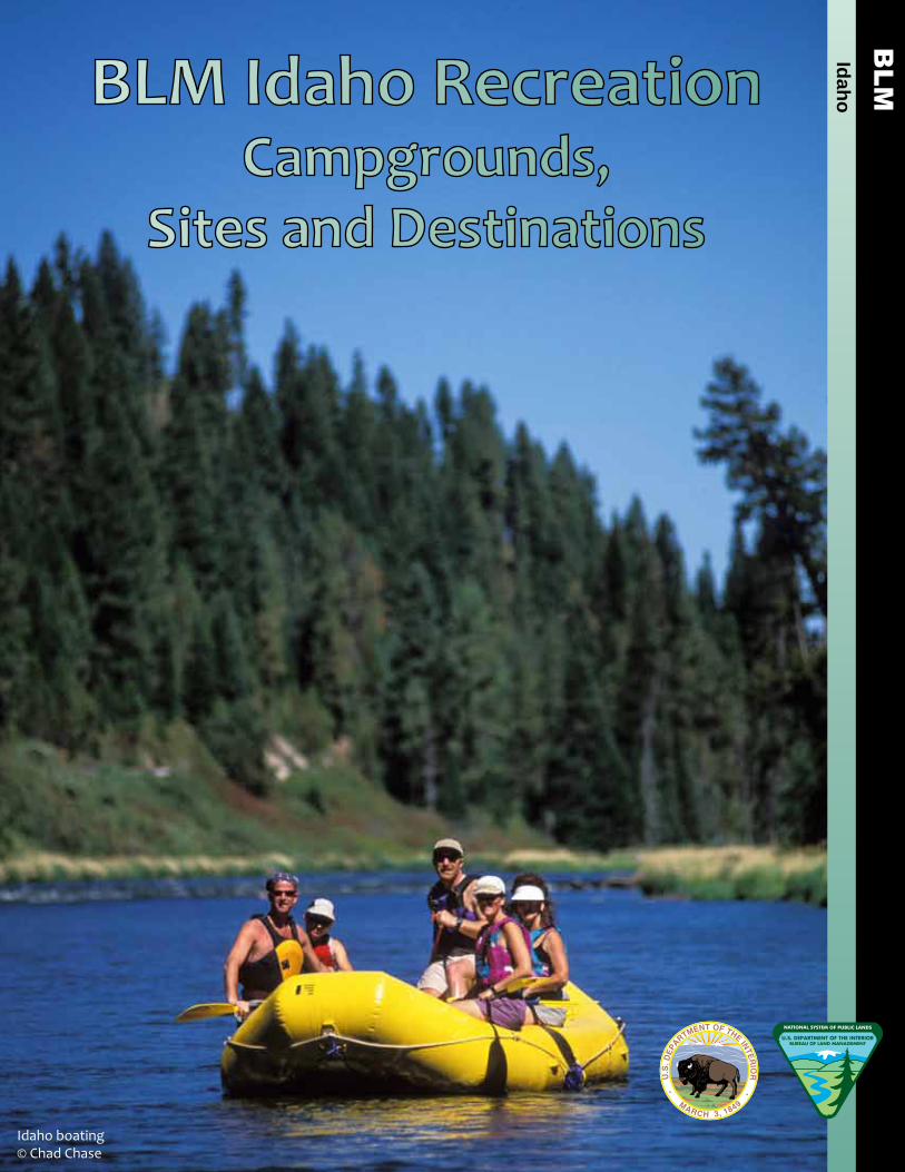
1 Idaho BLM Idaho Recreation Campgrounds, Sites and Destinations Idaho boating © Chad Chase
1
IdahoBLM Idaho Recreation Campgrounds,
Sites and Destinations
Idaho boating© Chad Chase

Inside Cover is blank

BLM Idaho Recreation Campgrounds,
Sites and Destinations
U.S. Department of the InteriorBureau of Land Management
Idaho State Office 1387 S. Vinnell Way
Boise, ID 83709(208) 373-4000
http://www.blm.gov/idwww.facebook.com/blmidahowww.youtube.com/blmidaho www.twitter.com/blmidaho

This page is blank

Table of Contents
Welcome to Your Public Lands 6
“Know Before You Go” 7
Contact Us 8
Map Legend 9
Southwestern Idaho
Bruneau Field Office 10-13Four Rivers Field Office 14-17Morley Nelson Snake River Birds of Prey 18-21 Owyhee Field Office 22-25
Northern Idaho
Coeur d’ Alene Field Office 26-29Cottonwood Field Office 30-33
Eastern Idaho
Challis Field Office 34-37Pocatello Field Office 38-41Salmon Field Office 42-45Upper Snake Field Office 46-49
Central Idaho
Burley Field Office 50-53Jarbidge Field Office 54-57Shoshone Field Office 58-61
Hulls Gulch National Recreation Trail© Glenn Oakley
Owyhee River Canyon
6
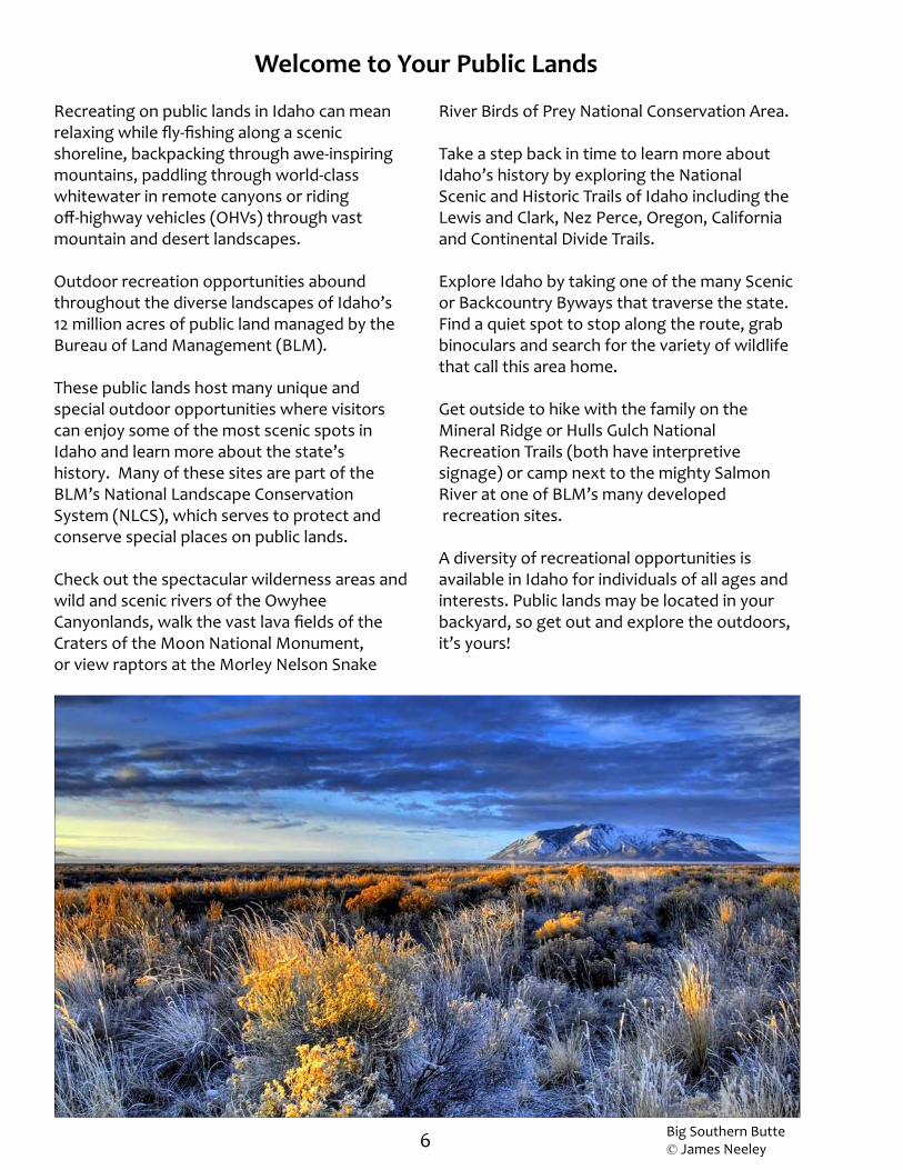
Recreating on public lands in Idaho can mean relaxing while fly-fishing along a scenic shoreline, backpacking through awe-inspiring mountains, paddling through world-class whitewater in remote canyons or riding off-highway vehicles (OHVs) through vast mountain and desert landscapes.
Outdoor recreation opportunities abound throughout the diverse landscapes of Idaho’s 12 million acres of public land managed by the Bureau of Land Management (BLM).
These public lands host many unique and special outdoor opportunities where visitors can enjoy some of the most scenic spots in Idaho and learn more about the state’s history. Many of these sites are part of the BLM’s National Landscape Conservation System (NLCS), which serves to protect and conserve special places on public lands.
Check out the spectacular wilderness areas and wild and scenic rivers of the Owyhee Canyonlands, walk the vast lava fields of the Craters of the Moon National Monument,or view raptors at the Morley Nelson Snake
River Birds of Prey National Conservation Area.
Take a step back in time to learn more about Idaho’s history by exploring the National Scenic and Historic Trails of Idaho including the Lewis and Clark, Nez Perce, Oregon, California and Continental Divide Trails.
Explore Idaho by taking one of the many Scenic or Backcountry Byways that traverse the state. Find a quiet spot to stop along the route, grab binoculars and search for the variety of wildlife that call this area home.
Get outside to hike with the family on the Mineral Ridge or Hulls Gulch National Recreation Trails (both have interpretive signage) or camp next to the mighty Salmon River at one of BLM’s many developed recreation sites.
A diversity of recreational opportunities is available in Idaho for individuals of all ages and interests. Public lands may be located in your backyard, so get out and explore the outdoors, it’s yours!
Welcome to Your Public Lands
Big Southern Butte © James Neeley
7
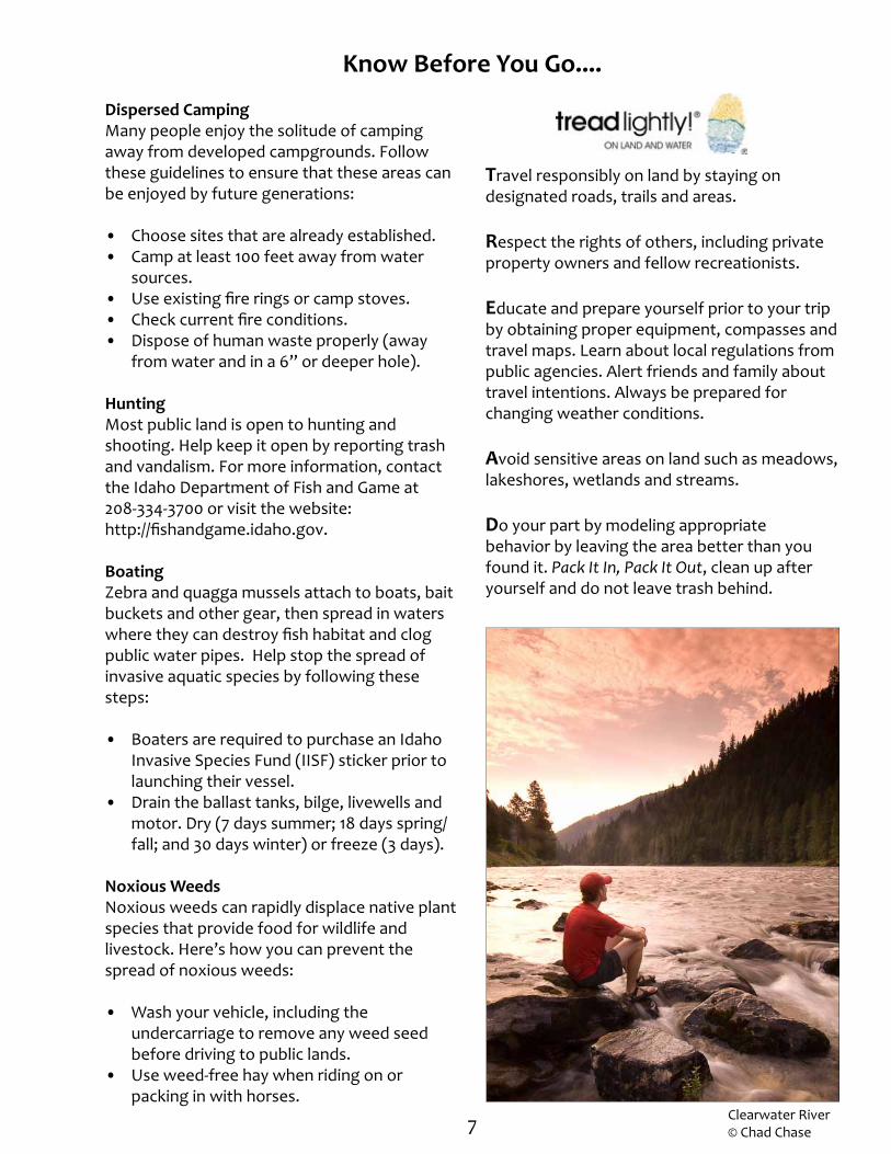
Know Before You Go....
Travel responsibly on land by staying on designated roads, trails and areas.
Respect the rights of others, including private property owners and fellow recreationists.
Educate and prepare yourself prior to your trip by obtaining proper equipment, compasses and travel maps. Learn about local regulations from public agencies. Alert friends and family about travel intentions. Always be prepared for changing weather conditions.
Avoid sensitive areas on land such as meadows, lakeshores, wetlands and streams.
Do your part by modeling appropriate behavior by leaving the area better than you found it. Pack It In, Pack It Out, clean up after yourself and do not leave trash behind.
Dispersed CampingMany people enjoy the solitude of camping away from developed campgrounds. Follow these guidelines to ensure that these areas can be enjoyed by future generations:
• Choose sites that are already established.• Camp at least 100 feet away from water
sources.• Use existing fire rings or camp stoves. • Check current fire conditions. • Dispose of human waste properly (away
from water and in a 6” or deeper hole).
HuntingMost public land is open to hunting and shooting. Help keep it open by reporting trash and vandalism. For more information, contact the Idaho Department of Fish and Game at 208-334-3700 or visit the website: http://fishandgame.idaho.gov.
BoatingZebra and quagga mussels attach to boats, bait buckets and other gear, then spread in waters where they can destroy fish habitat and clog public water pipes. Help stop the spread of invasive aquatic species by following these steps:
• Boaters are required to purchase an Idaho Invasive Species Fund (IISF) sticker prior to launching their vessel.
• Drain the ballast tanks, bilge, livewells and motor. Dry (7 days summer; 18 days spring/fall; and 30 days winter) or freeze (3 days).
Noxious WeedsNoxious weeds can rapidly displace native plant species that provide food for wildlife and livestock. Here’s how you can prevent the spread of noxious weeds:
• Wash your vehicle, including the undercarriage to remove any weed seed before driving to public lands.
• Use weed-free hay when riding on or packing in with horses.
Clearwater River © Chad Chase
8
BLM Idaho State Office1387 S. Vinnell WayBoise, Idaho 83709Public Desk: 208-373-4000E-mail: [email protected]
Southwestern Idaho Bruneau Field Office 3948 Development Avenue Boise, ID 83705 Phone: 208-384-3300
Four Rivers Field Office/ Snake River Birds of Prey National Conservation Area 3948 Development Avenue Boise, ID 83705 Phone: 208-384-3300
Owyhee Field Office 20 First Avenue West Marsing, ID 83639 Phone: 208-896-5912
Northern Idaho
Coeur d’Alene Field Office 3815 Schreiber Way Coeur d’Alene, ID 83815 Phone: 208-769-5000
Cottonwood Field Office 1 Butte Drive Cottonwood, ID 83522 Phone: 208-962-3245
Eastern Idaho
Challis Field Office 1151 Blue Mountain Road Challis, ID 83226 Phone: 208-879-6200
Pocatello Field Office 4350 Cliffs Drive Pocatello, ID 83204 Phone: 208-478-6340
Salmon Field Office 1206 South Challis Street Salmon, ID 83467 Phone: 208-756-5400
Upper Snake Field Office 1405 Hollipark Drive Idaho Falls, ID 83401 Phone: 208-524-7500
Central Idaho
Burley Field Office 15 East 200 South Burley, ID 83318 Phone: 208-677-6600
Jarbidge Field Office 2536 Kimberly Road Twin Falls, ID 83301 Phone: 208-735-2060
Shoshone Field Office/ Craters of the Moon National Monument 400 West “F” Street Shoshone, ID 83352 Phone: 208-732-7200
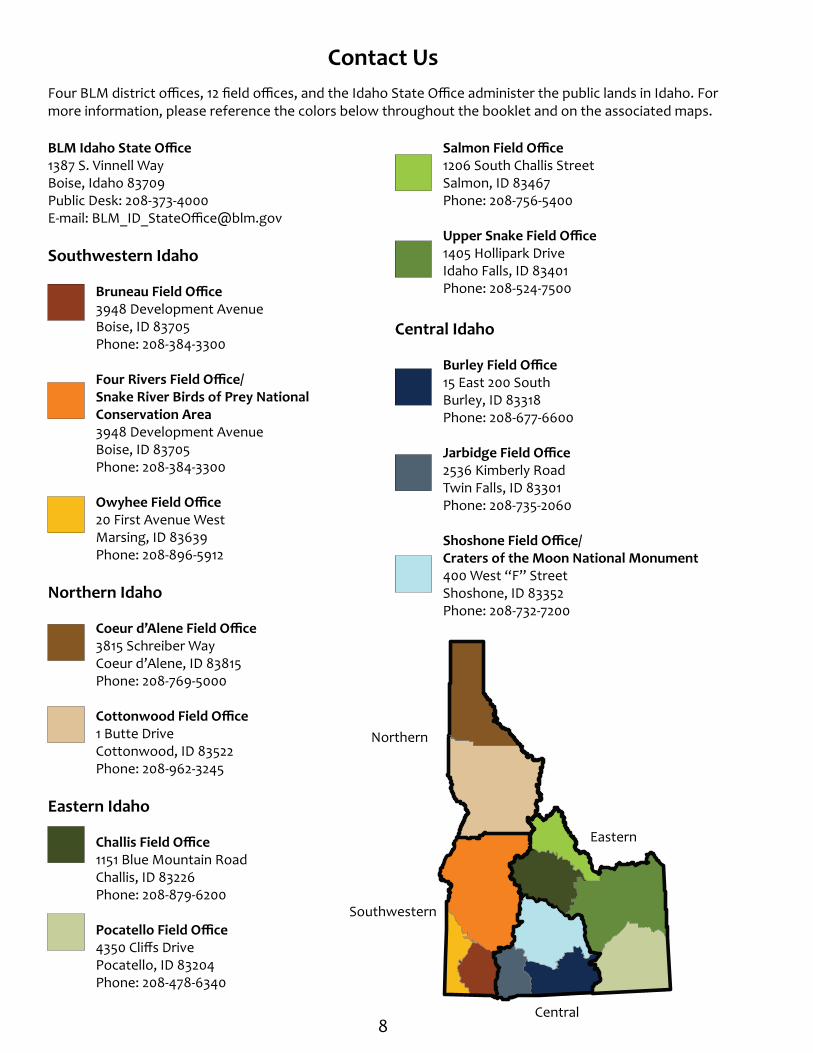
Contact UsFour BLM district offices, 12 field offices, and the Idaho State Office administer the public lands in Idaho. For more information, please reference the colors below throughout the booklet and on the associated maps.
Northern
Central
Eastern
Southwestern

9
Map LegendPlease reference the following legend for maps throughout the booklet.
Local student illustration depicting “favorite activity on public lands.” Don’t miss more student illustrations on the back of the statewide map.
Boating the Payette River
Designated Wilderness Area
National Wild and Scenic River Special Management Area County Boundary Interstate Highway
US Highway
State Highway
£
Map Symbols
Note: Roads partly revised 2011
“No warranty is made by the Bureau of Land Management (BLM). The accuracy, reliability, or completeness of these data for individual use or aggregate use with other data is not guaranteed. Map scale varies in illustrations.” Created by BLM, Idaho State Office, 2012.
Land Status Managing Agency
Bureau of Land Management
Bureau of Reclamation
Corps of EngineersMilitary Reservations and Corps of EngineersIndian Reservation
Bankhead-Jones LU Lands (Admin by Acquiring Agency)National Grasslands (Admin by USFS)
Military Land
National Park Service
National Wildlife Refuge
Private
State of Idaho
US Forest Service
State of Idaho Fish & Game; State of Idaho Parks & Rec
Southwestern Idaho
Northern Idaho
Burley Field OfficeJarbidge Field Office
Central Idaho
Recreation Site and General BLM Management Area
Coeur d’ Alene Field OfficeCottonwood Field Office
Eastern Idaho
Challis Field OfficePocatello Field OfficeSalmon Field OfficeUpper Snake Field Office
Bruneau Field OfficeFour Rivers Field Office
Owyhee Field Office
Morley Nelson Snake River Birds of Prey NCA
Shoshone Field Office/Craters of the Moon NCA
###
#
##
####
##
#
§̈¦15
¬«21
£¤93
10
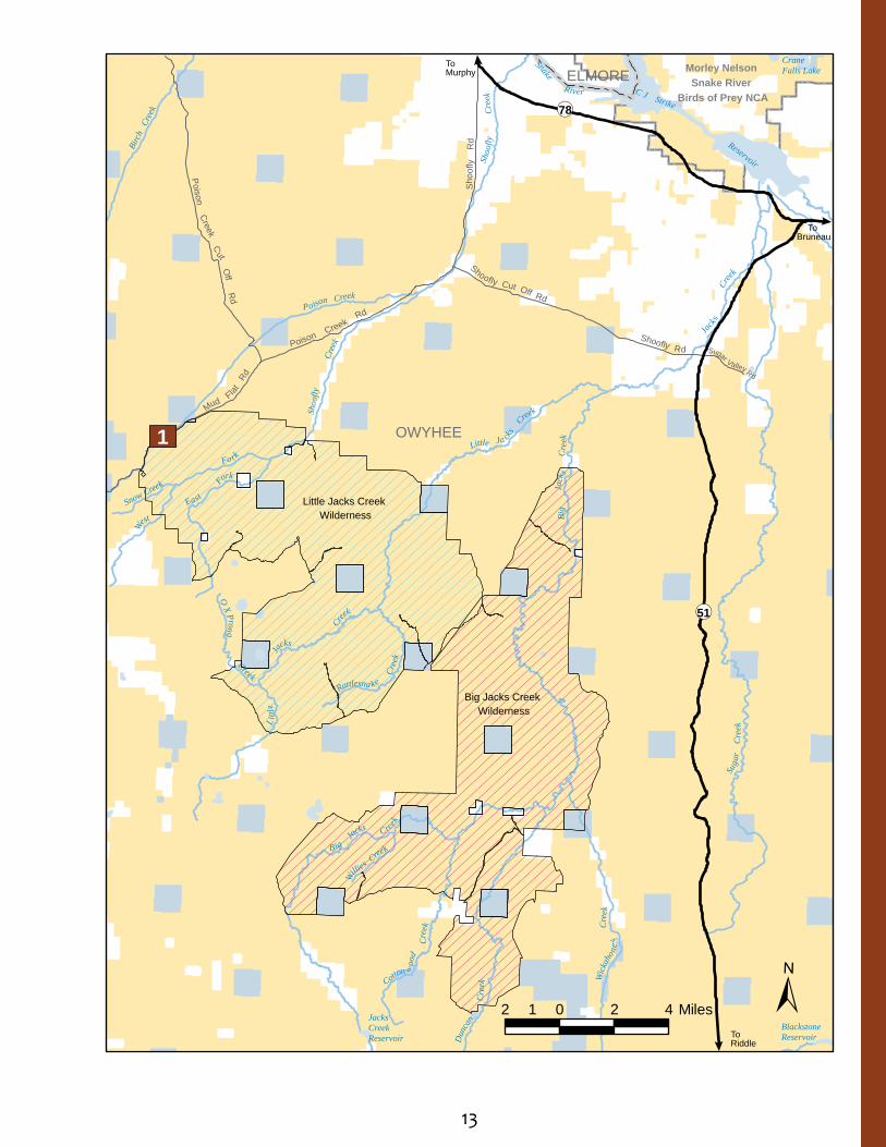
Some of the most spectacular and untouched high desert landscapes in the United States can be found here. From the sweeping plateaus and towering canyons of the Owyhee Canyonlands and the solitude of the Big and Little Jacks Creek Wilderness Areas, to the excellent wildlife viewing along the Owyhee Uplands Backcountry Byway, memorable vistas and experiences are around each turn.
Three wilderness areas including the Big Jacks Creek Wilderness, Little Jacks Creek Wilderness, and the Bruneau-Jarbidge River Wilderness are located in this region. The waterways through much of these wilderness areas are also designated as Wild & Scenic Rivers.
The spectacular Owyhee, Deep Creek, Bruneau and Jarbidge Rivers are floatable in the spring, but are only recommended for experienced and well-prepared boaters. These remote rivers have difficult put-in and take-out locations (especially in bad weather) and have challenging Class II - V whitewater with difficult portages. A waterproof river guide is available from the BLM.
Visitors to this area can also enjoy bird watching, camping, big game and upland bird hunting, hiking, motorized recreation, horseback riding and driving for pleasure.
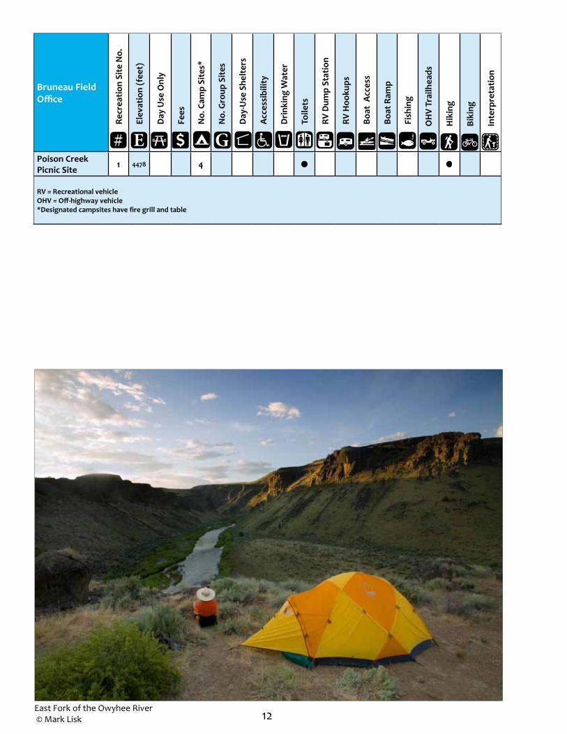
The only developed recreation spot in this region is Poison Creek picnic site. This site has tables, grills, fire grates, one vault toilet, shaded areas and a small trail.
The Owyhee Uplands Back Country Byway, also called Mud Flat Road, is a scenic driving route across the Owyhee Plateau and Canyonlands. Traversing 92 miles in Idaho and 12 in Oregon, the Byway allows visitors to explore different vegetative zones, including juniper and mahogany stands and sagebrush and aspen-covered plateaus.
Take proper precautions when visiting this harsh, remote environment. Cell phone
coverage is unlikely. To ensure a safe trip and return, be prepared with proper equipment, maps, compasses, clothing and knowledge of the general area and weather conditions.
Wilderness areas and wild and scenic rivers are part of the BLM’s National Landscape Conservation System, which serves to protect and conserve special places on public lands.
Help care for and protect this fragile environment for current and future generations by leaving no trace and packing out what you pack in. Decrease the chance of contaminating the water supply and minimize wildlife disturbance by camping at least 200 feet from streams.
Southwestern Idaho: Bruneau Field Office
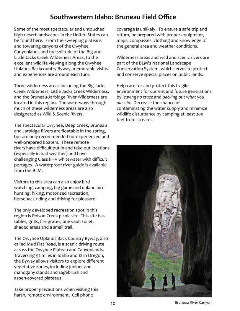
Bruneau River Canyon

11Battle Creek Wild and Scenic River
Exploring the area on bikes© Chad Chase
12
Bruneau Field Office
Recr
eatio
n Si
te N
o.
Elev
atio
n (f
eet)
Day
Use
Onl
y
Fees
No.
Cam
p Si
tes*
No.
Gro
up S
ites
Day
-Use
She
lter
s
Acc
essi
bilit
y
Dri
nkin
g W
ater
Toile
ts
RV D
ump
Stat
ion
RV H
ooku
ps
Boat
Acc
ess
Boat
Ram
p
Fish
ing
O
HV
Trai
lhea
ds
H
ikin
g
B
ikin
g
I
nter
pret
atio
n
Poison Creek Picnic Site 1 4478 4
RV = Recreational vehicleOHV = Off-highway vehicle*Designated campsites have fire grill and table
E G#
East Fork of the Owyhee River © Mark Lisk
13
Little Ja cks
C
reek
Li
ttle
J
acks
Cree
k
To Bruneau
To Murphy
To Riddle
OWYHEE
ELMORE
Shoofly Cut Off Rd
Shoofly Rd Sugar Valley Rd
S
hoof
ly
Rd
Poison C
reek Rd
Mud F
lat
Rd
Poison Creek C
ut Off R
d
¬«51
¬«78
Little Jacks Creek Wilderness
Big Jacks Creek Wilderness
Birc
h C
reek
Snow Creek
Poison Creek
West
Fo rk
Shoo
fly
C
reek
East
Fork
O X Prong Creek
Ja
cks
Creek
S
hoof
ly
Cre
ek
Su
gar
Cre
ek
Wick
aho ne
y C
ree k
Cotton w
ood
Cre
ek
Dun
can
Cre
ek
B ig
Jacks Cree
k
Big
Jack
s
Cre
ek
Willie
s Cree
k
Rattlesna ke
Cre
ek
Crane Falls Lake
Blackstone Reservoir
Jacks Creek Reservoir
Snake River C J Strike Reservoir
Morley Nelson Snake River
Birds of Prey NCA
±2 0 2 41 Miles
1

14
Southwestern Idaho: Four Rivers Field Office
This region is the backyard of Idaho’s largest city (Boise), yet offers easy access to unspoiled destinations for outdoor adventure.
The 130-mile Ridge to Rivers Trail System offers hikers, bikers and wildlife viewers plenty of trails to explore. Seven miles up Eighth Street from Boise’s North End, the three-mile Hulls Gulch National Recreation Trail offers a quiet escape from the city and interpretive signs teach visitors about the unique natural history of the Boise Foothills.
In the mid-1800s, thousands of pioneers followed the Oregon Trail 2,000 miles from Missouri to Oregon in search of a better life. Located southeast of Boise, the 135-mile stretch of the Oregon National Historic Trail, can be experienced from a car or explored on foot. Original wagon wheel ruts are visible today on the North Trail and Sinker Creek segments.
At Bonneville Point, visitors can stand in the
same spot where Captain Benjamin Bonneville and his expedition party overlooked the valley he named Les Bois, site of the city that today bears the same name — Boise. The site is also an access point for the Oregon Trail and a place to hike, picnic, geocache and view wildlife.
The Payette River offers opportunities for recreationists of all skill levels to kayak, canoe and fish. Motorized and non-motorized boating are allowed and rafting enthusiasts can expect rapids of varying difficulties. Local outfitters offer half and full day trips of this scenic river.
Brownlee Reservoir is a popular fishing location known for its great catfish, crappie and small mouth bass. Fishermen can set-up camp and launch their fishing boats at Steck Park campground. Steck Park, located at the southern end of the 56-mile-long reservoir, offers access to Brownlee Reservoir along the Snake River from the Idaho side of Hell’s Canyon.
Biking the Ridge to Rivers trail system

15Little Gem motorcycle park Hulls Gulch National Recreation Trail
Boise Whitewater Festival
16
Four Rivers Field Office
Recr
eatio
n Si
te N
o.
Elev
atio
n (f
eet)
Day
Use
Onl
y
Fees
No.
Cam
p Si
tes*
No.
Gro
up S
ites
Day
-Use
She
lter
s
Acc
essi
bilit
y
Dri
nkin
g W
ater
Toile
ts
RV D
ump
Stat
ion
RV H
ooku
ps
Boat
Acc
ess
Boat
Ram
p
Fish
ing
O
HV
Trai
lhea
ds
H
ikin
g
B
ikin
g
I
nter
pret
atio
n
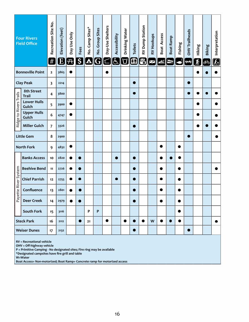
Bonneville Point 2 3865
Clay Peak 3 2214
8th Street Trail 4 3800
Lower Hulls Gulch 5 3900
Upper Hulls Gulch 6 4747
Miller Gulch 7 3326
Little Gem 8 2900
North Fork 9 4832
Banks Access 10 2820
Beehive Bend 11 2726
Chief Parrish 12 2755
Confluence 13 2801
Deer Creek 14 2979
South Fork 15 3116 P P
Steck Park 16 2112 21 W
Weiser Dunes 17 2132
RV = Recreational vehicleOHV = Off-highway vehicleP = Primitive Camping - No designated sites; Fire ring may be available *Designated campsites have fire grill and tableW=WaterBoat Access= Non-motorized; Boat Ramp= Concrete ramp for motorized access
E G#
Paye
tte
Rive
r Sys
tem
Ridg
e to
Riv
ers
Trai
ls
17
Bank s
Lowman Hwy
To New Meadows
To MountainHome
Olds Ferry Rd
! !
!
!
!
! !!
!!
!! !
!
!
!
!
!
!!
!
! !
!
!
!
!
!!
!
!
!
!
!!
Kuna
Star
Mesa
Nampa
Boise
Eagle
Notus
Parma
Banks
Wilder
Emmett
Crouch
Weiser
Marsing
Gardena
Payette
Crystal
Midvale
Cascade
Council
MeridianHomedale
Caldwell
Donnelly
Greenleaf
Middleton
Fruitland
Cambridge
Olds Ferry
New Plymouth
Smiths Ferry
GardenValley
Horseshoe Bend
To Jordan Valley, Ore
To Ontario, Ore
GEM
ADA
BOISE
WASHINGTON VALLEY
ADAMS
CANYON
PAYETTE
OWYHEE ELMORE
¬«55¬«52
¬«71
¬«16
¬«19
¬«69
¬«78
¬«45
¬«72
¬«44
¬«55
¬«55
¬«21
¬«52
¬«52
¬«19
¬«55
£¤20
£¤95
£¤95
£¤95
§̈¦84
§̈¦184
§̈¦84
Cascade Reservoir
Lake Lowell
Crane Creek Reservoir
Brownlee Reservoir
Paddock Valley Reservoir
Black Canyon Reservoir
Ben Ross Reservoir
Mann Creek Reservoir
Lucky Pea
k L
a ke
Boise River
Snake River
Sna ke River
Payette River
Weiser Riv er
N
orth
Fo rk
P
ayet
te
Rive
r
Little Weiser River
Weiser R
iver
Midd le Fork Weiser
Riv
er
Jump
Cree
k
±5 0 5 10
Miles
OR
EG
ON
OR
EG
ON
9
16
17
3
1112
131415
7 654
2
10
8

18
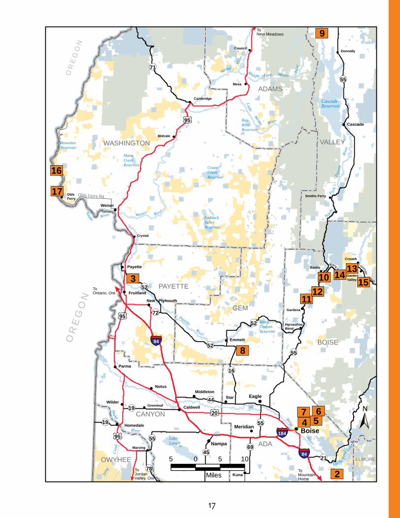
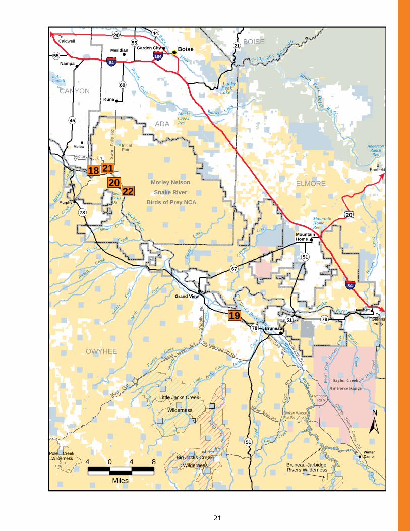
Southwestern Idaho: Morley Nelson Snake River Birds of Prey National Conservation Area
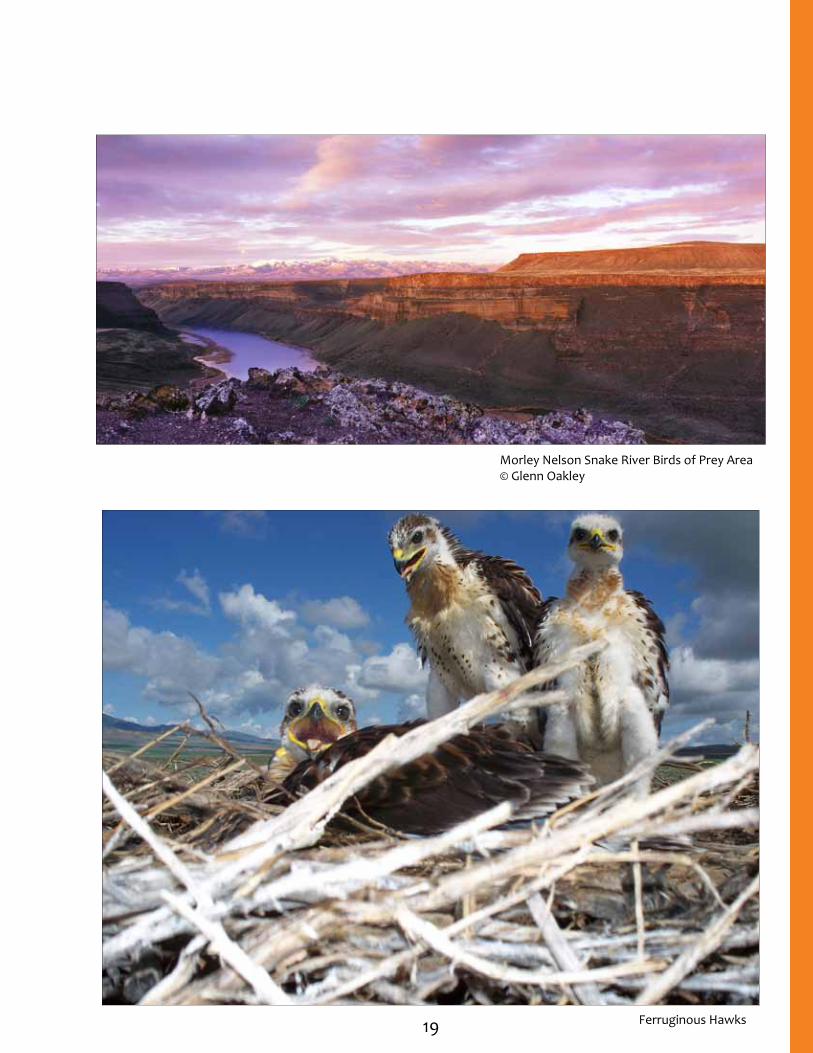
This area’s spectacular, vast and unique landscape supports one of the world’s densest concentrations of nesting birds of prey. Congress established the Morley Nelson Snake River Birds of Prey National Conservation Area (NCA) in 1993 to help recognize and protect the area’s wildlife values. This 485,000-acre area hosts about 800 pairs of falcons, eagles, hawks and owls that arrive each spring to mate and raise their young. In addition to outstanding bird and wildlife viewing, this area hosts various recreational opportunities. Visitors can sightsee, ride on horseback, hike, hunt, mountain bike, picnic and camp. The NCA is one of the many units within the BLM’s National Landscape Conservation System which serves to protect and conserve special places on public lands.
Catch a glimpse of the area’s birds of prey at Dedication Point, a spectacular overlook on the rim of the Snake River Canyon. A ¼-mile trail with interpretive signs offers insights about the birds, geology and other wildlife.
Experience the magnificence of this area from the waters and shorelines of Cove Recreation
Site. This is a popular area to fish, hike, view wildlife, boat (motorized and non-motorized), waterski, swim and picnic. About one mile east of the dam, day-use and overnight camping facilities are available on the south shore of C.J. Strike Reservoir.
Halverson Lake is nestled along the canyon wall with opportunities for all types of outdoor adventure, as well as cultural education. During a visit to Halverson Lake, visitors can also check out Celebration Park to learn about the history of Native Americans who still use this area.
Spring and fall weather conditions in sheltered canyon areas average 5-10 °F warmer than temperatures in nearby Boise. This makes recreation outdoors possible in the late winter, spring and fall when many higher-elevation recreation areas are still affected by weather.
A visitor guide containing general maps of the NCA, raptor viewing information, shooting regulations/information and recreational opportunities is available from the BLM.
Morley Nelson Snake River Birds of Prey Area© Glenn Oakley
19
Morley Nelson Snake River Birds of Prey Area© Glenn Oakley
Ferruginous Hawks
20 Morley Nelson Snake River Birds of Prey Area© Glenn Oakley
Morley Nelson Snake River Birds of Prey National Conservation Area
Recr
eatio
n Si
te N
o.
Elev
atio
n (f
eet)
Day
Use
Onl
y
Fees
No.
Cam
p Si
tes*
No.
Gro
up S
ites
Day
-Use
She
lter
s
Acc
essi
bilit
y
Dri
nkin
g W
ater
Toile
ts
RV D
ump
Stat
ion
RV H
ooku
ps
Boat
Acc
ess
Boat
Ram
p
Fish
ing
O
HV
Trai
lhea
ds
H
ikin
g
B
ikin
g
I
nter
pret
atio
n
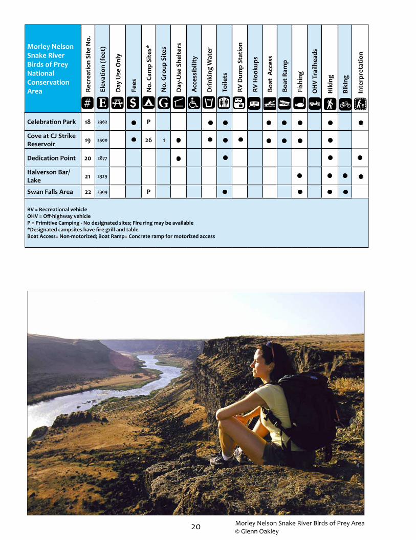
Celebration Park 18 2362 P
Cove at CJ Strike Reservoir 19 2500 26 1
Dedication Point 20 2877
Halverson Bar/Lake 21 2329
Swan Falls Area 22 2309 P
RV = Recreational vehicleOHV = Off-highway vehicleP = Primitive Camping - No designated sites; Fire ring may be available *Designated campsites have fire grill and tableBoat Access= Non-motorized; Boat Ramp= Concrete ramp for motorized access
E G#
21
OWYHEE
ADA
ELMORE
CANYON
BOISE
Little Jacks Creek
Wilderness
Big Jacks Creek Wilderness
Pole Creek Wilderness
Bruneau-Jarbidge Rivers Wilderness
Poison Creek R
d
Mud Flat
Rd
S
hoo
fly
Rd
Shoofly Cut Off Rd
Hot Creek Rd
Hot Springs Rd
Clover Three Creek Rd
Overlook Rd
Miss le Base RdBroken WagonFlat Rd
C
CC
Rd
Sw
an F
alls
Rd
LnVictory
Initial Point
¬«78
¬«51
¬«51
¬«21
¬«45
¬«67
¬«69
¬«55£¤20
£¤20
§̈¦84
§̈¦184
¬
¬«51
¬«78¬«78
§̈¦84
¬«44
¬«55
To GlennsFerry
To Caldwell
To Fairfield
!
!
!
!
!
!
!
!
!
!
Kuna
Murphy
Bruneau
Hammett
Meridian
Grand View
Garden City
Mountain Home
Boise!
Melba
!
Winter Camp
Nampa
Snake River
Lake Lowell Lucky
Peak Lake
Mountain Home Res
Blacks Creek Res
South Fork Boi s e Ri v er
P
o iso
n Creek
Sh
oofly
Cre
ek
L
ittle Jacks C
reek
Bi g
Jac
ks
Cree
k
Sug
ar
Cre
ek
Jacks
C
ree k
Clov er Cr eek
B
irch
Cree
k
C
astle
Cree
k
Pickett
Creek
Fossil
Cr eek
Sinker C
reek
Briar Cree
k
R
abbit
C
reek
Bruneau R iver
C
an
yon
Creek
C
orde
r
C
reek
Snake Rive r
Browns Creek
Wea
st F
ork
Bro
wns
Cre
ek
P
ot Hole
Cre
ek
Ben
nett
Cre
ek
C J St r ike Reservoir
A r row rock Rese
r v
oir
AndersonRanch
Res
Tenmile Creek
Blacks Cree
k
Boise River
Hot
Creek
Swan Falls Dam
19
2220
18 21
Saylor Creek
Air Force Range
Morley Nelson
Snake River
Birds of Prey NCA
4 0 4 8
Miles
±

22
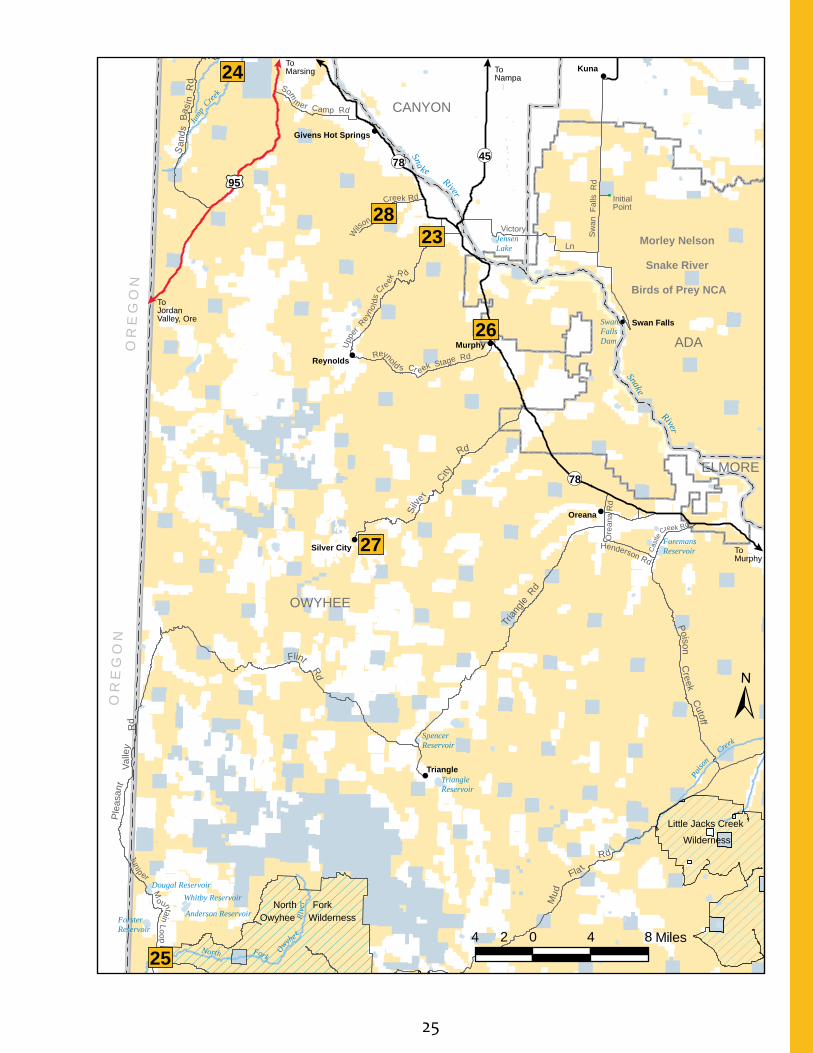
Southwestern Idaho: Owyhee Field Office
From the sheer rock cliffs and magnificent plateaus of the Owyhee Canyonlands, to the scenery and wildlife viewing available along the Owyhee Uplands Backcountry Byway, the southwest corner of Idaho is a special place to visit. Visitors will find plenty of opportunities to explore, find solitude, and experience some of nature’s most wild places in this remote, rugged country. The area includes two wilderness areas and multiple sections of wild and scenic rivers.
The Owyhee Uplands Backcountry Byway represents high desert scenery at its finest. Along the route, visitors are treated to views of the surrounding sagebrush-steppe ecosystem that provides habitat for over 180 species of birds and mammals. Scenic geologic formations, composed of volcanic rock deposited 8-12 million years ago, are also present in this area.
For off-highway vehicle (OHV) enthusiasts, this area features three popular trailheads along the Owyhee Front. Trails include single tracks for motorcycles and wider trails and two-tracks for all terrain vehicles (ATVs) and other motorized vehicles.
Plenty of non-motorized adventures are also available. Hikers who travel ¼ mile to Jump
Creek Falls will discover a lush riparian community filled with waterbirch and red osier dogwood trees.
History comes alive at the Silver City campground, located in a partially restored 19th century mining town in the Owyhee Mountains.
The Owyhee River System, sometimes called the “Grand Canyon of the Owyhee,” is famous for its deep canyons, steep cliffs, turbulent whitewater, brilliant wildflowers and abundant wildlife. Golden eagles, falcons, hawks, bighorn sheep and deer all call this area home. Much of the Owyhee River and its tributaries are designated as wild and scenic rivers and nearly 70 miles of the river, upstream from the Idaho-Oregon border, is within the Owyhee River Wilderness area.
These designations protect the unique character of this area and make it part of the BLM’s National Landscape Conservation System, which serves to protect and conserve special places on public lands.
Rafting and kayaking the Owyhee with its Class II - V whitewater is popular in the spring during higher water flows. Low water float trips are also possible in smaller craft.
Owyhee River Canyon © Glenn Oakley
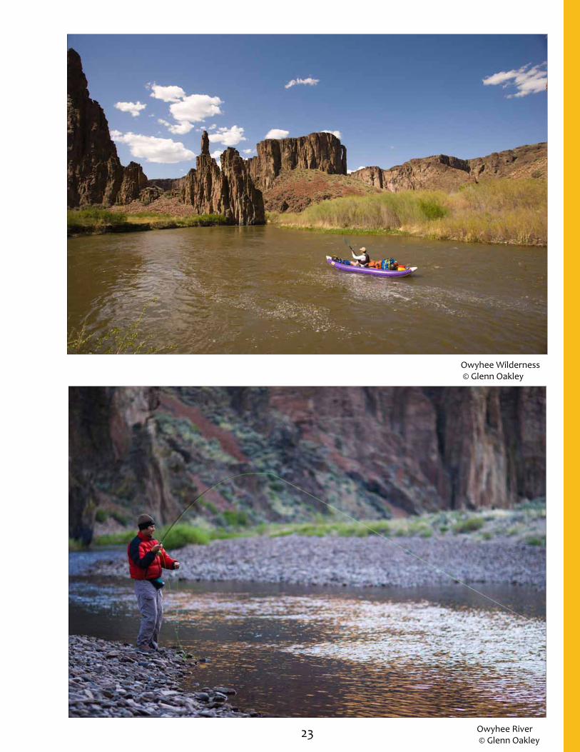
23 Owyhee River © Glenn Oakley
Owyhee Wilderness © Glenn Oakley

24
Owyhee Field Office
Recr
eatio
n Si
te N
o.
Elev
atio
n (f
eet)
Day
Use
Onl
y
Fees
No.
Cam
p Si
tes
*
No.
Gro
up S
ites
Day
-Use
She
lter
s
Acc
essi
bilit
y
Dri
nkin
g W
ater
Toile
ts
RV D
ump
Stat
ion
RV H
ooku
ps
Boat
Acc
ess
Boat
Ram
p
Fish
ing
O
HV
Trai
lhea
ds
H
ikin
g
B
ikin
g
I
nter
pret
atio
n
Hemingway Butte 23 2480
Jump Creek 24 2650
North Fork 25 4763 7
Rabbit Creek 26 2772
Silver City 27 6161 6
Wilson Creek 28 2762
RV = Recreational vehicleOHV = Off-highway vehicle*Designated campsites have fire grill and tableBoat Access= Non-motorized; Boat Ramp= Concrete ramp for motorized access
E G#
Owyhee Uplands Backcountry Byway
25
Snake River
Mud
Fla t
Rd
")
")
")
!
!
!
!
!
!
!
!Kuna
Oreana
Murphy
Triangle
Reynolds
Swan Falls
Silver City
Givens Hot Springs
To Jordan Valley, Ore
To Marsing To
Nampa
To Murphy
Morley Nelson
Snake River
Birds of Prey NCA
Sw
an F
alls
Rd
Ln
Trian
gle R
d
Victory
Silve
r
City
Rd
P oison Creek C
utoff
Flint Rd
Ple
asan
t
Valle
y
Rd
Junip er M
ountain LoopC
astle
Creek Rd
Sna ke RiverU
pper
Rey
nold
s C
re
ek
R d
Wilso
n
Creek Rd
Reynold s Cr eek Stage Rd
Som
mer Camp Rd
San
ds B
asi n
Rd
Henderson Rd
Ore
ana
Rd
OWYHEE
ADA
CANYON
ELMORE
¬«45
¬«78
¬«78
£¤95
North Fork Owyhee Wilderness
Little Jacks Creek
Wilderness
Triangle Reservoir
Dougal Reservoir
Forster Reservoir
Jensen Lake
Foremans Reservoir
Spencer Reservoir
Whitby Reservoir
Po
iso
n C
reek
Anderson Reservoir
North Fork O
wyhe e
Riv
er
Jump
Cree
k
Swan Falls Dam
±
4 0 4 82 Miles
OR
EG
ON
OR
EG
ON
24
2823
26
27
25
Initial Point

26
Northern Idaho: Coeur d’ Alene Field Office
This “gem of the north” is not only valued by locals, but also by visitors for its beautiful scenery, recreational opportunities and variety of amenities. This serene, scenic area is also the perfect spot to escape crowds and be physically active on public lands.
Beautiful Lake Coeur d’Alene offers outstanding fishing, hiking, boating and nature viewing. Three boat launch sites are available at Blackwell Island, Mineral Ridge and Killarney Lake. Overnight boating guests will enjoy three boat-in campgrounds at Popcorn Island, Mica Bay and Windy Bay Boater Parks.
Hiking in this area is a popular way to view spectacular vistas of Lake Coeur d’ Alene. The 3.3-mile Mineral Ridge National Recreation Trail is an invigorating and educational hike. As visitors meander down this trail, they will learn about forest plants, animals and their interrelationships at 22 stations. The Beauty
Bay recreation site offers a short half-mile trail with commanding views and a nice picnic area.
Wildlife viewing is an attraction to this region. Each winter from November through February, a migrating population of up to 150 bald eagles visits the area to feed on spawning kokanee salmon.
The St. Joe River is a popular fly fishing and elk hunting destination. Overnight guests can stay at Huckleberry Campground, the only full-service RV campground on this stretch of the river. During the summer, visitors enjoy swimming, rafting, canoeing and tubing here.
Check out the lake views from the comfort of a car on the beautiful Lake Coeur d’Alene Scenic Byway. Glorious views of lakes and mountains are around every curve on this scenic tour of the countryside.
Eagle watch at Lake Coeur d’ Alene
Eagle at Lake Coeur d’ Alene

27 Blue Creek Bay
Blackwell Island

28
Coeur d’Alene Field Office
Recr
eatio
n Si
te N
o.
Elev
atio
n (f
eet)
Day
Use
Onl
y
Fees
No.
Cam
p Si
tes
*
No.
Gro
up S
ites
Day
-Use
She
lter
s
Acc
essi
bilit
y
Dri
nkin
g W
ater
Toile
ts
RV D
ump
Stat
ion
RV H
ooku
ps
Boat
Acc
ess
Boat
Ram
p
Fish
ing
O
HV
Trai
lhea
ds
H
ikin
g
B
ikin
g
I
nter
pret
atio
n
Beauty Bay 29 2575
Blackwell Island 30 2142
Blue Creek Bay 31 2148
Blue Creek Trail 32 2162
Crater Lake¹ 33 6250 P
Crater Peak¹ 34 6345 P
Gamlin Lake 35 2112
Huckleberry Campground 36 2247 30 3 WE
Killarney Lake Boat Launch 38 2148 12
Killarney Lake Picnic Site 39 2230 2
Mica Bay Boater Park** 40 2132 16
Mineral Ridge Boat Launch 41 2139
Mineral Ridge Scenic Area/ National Recreation Trail
42 2152
Orphan Point Saddle¹ 43 5912 P
Popcorn Island** 44 2129 2
Sheep Springs¹ 45 5442 P
Tingley Springs¹ 46 5055 P
Windy Bay Boater Park** 47 2132 14
RV = Recreational vehicleOHV = Off-highway vehicleP = Primitive Camping - No designated sites; Fire ring may be available *Designated campsites have fire grill and table** = No vehicle access, boat-in only E=Electricity; W=WaterBoat Access= Non-motorized; Boat Ramp= Concrete ramp for motorized access¹ = High-clearance vehicles recommended
E G#

29
To Potlatch
To Sandpoint
St Joe River Rd
!(
!
!
!!
!
!
!
!
!
!
!
!
!
!
!
!
SHOSHONE
KOOTENAI
BONNER
BENEWAH
LATAH
¬«3
¬«41
¬«5
¬«6
¬«54
¬«200
¬«53
¬«4
¬«60
¬«57
¬«58
!
!
!!¬«3
¬«97
£¤95
£¤2
£¤95
§̈¦90
§̈¦90
Hayden Lake
Chatcolet Lake
Spokane River
Turtle Lake
Priest River
Coeur d’ Alen e Rive r
Lake
Pend O
reille
Coe
ur
d'
Alen
e
La
ke
S t Joe River
Gem
Lane
Emida
Santa
Avery
Sagle
Tensed
Calder
Worley
Osburn
Hayden
Clarkia
De Smet
St. Joe
Plummer
Wallace
KelloggCataldo
Bayview
Cabinet
Laclede
Oldtown
Fernwood
Harrison
Rathdrum
Chatcolet
Pinehurst
Blanchard Careywood
Cocolalla
St. Maries
Post Falls
Spirit Lake
Priest River
Coeur d'Alene
!
!!
!
Athol
!
!
!
!
!
Rose Lake
!
!
!
!
!
!
!
!
35
30
29 42413132
40
47
443938
4645
36
433433
No vehicle access,boat-in
only
No vehicle access,boat-in
only
MO
NTAN
AWA
SH
ING
TO
N
±
10 0 10
Miles
5
30
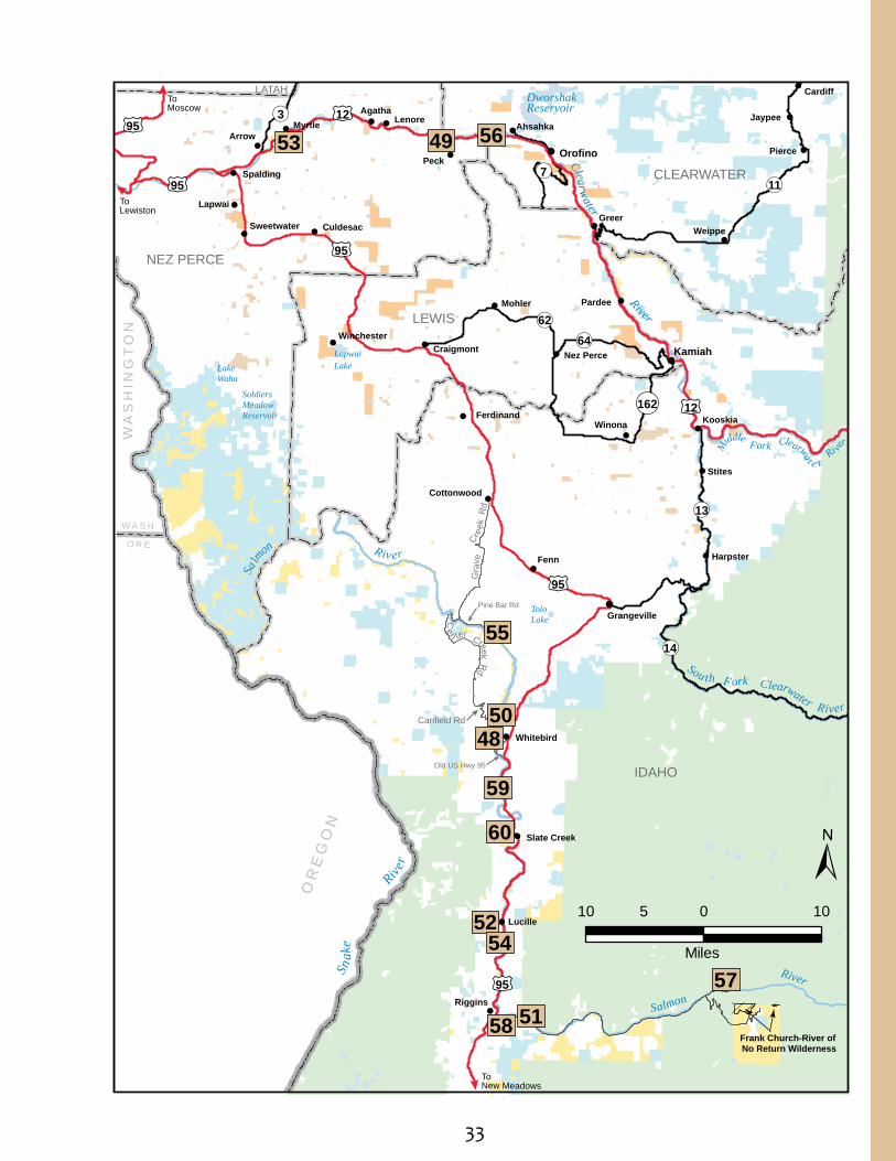
Northern Idaho: Cottonwood Field Office
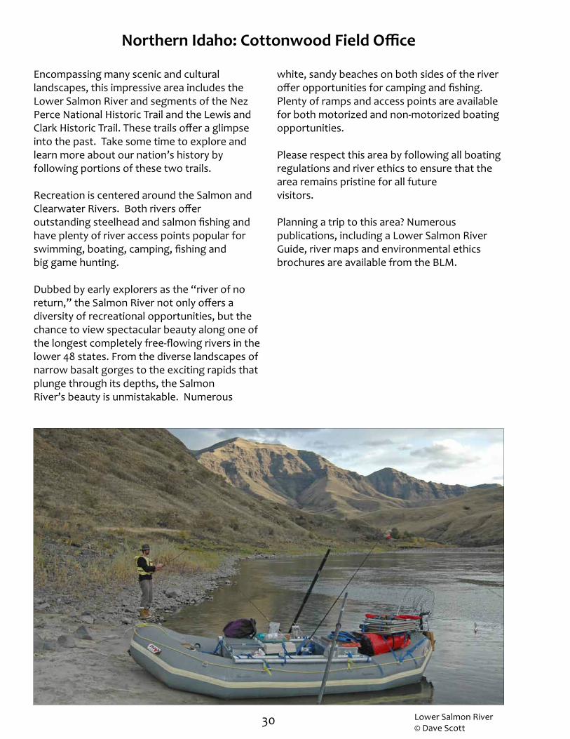
Encompassing many scenic and cultural landscapes, this impressive area includes the Lower Salmon River and segments of the Nez Perce National Historic Trail and the Lewis and Clark Historic Trail. These trails offer a glimpse into the past. Take some time to explore and learn more about our nation’s history by following portions of these two trails.
Recreation is centered around the Salmon and Clearwater Rivers. Both rivers offer outstanding steelhead and salmon fishing and have plenty of river access points popular for swimming, boating, camping, fishing and big game hunting.
Dubbed by early explorers as the “river of no return,” the Salmon River not only offers a diversity of recreational opportunities, but the chance to view spectacular beauty along one of the longest completely free-flowing rivers in the lower 48 states. From the diverse landscapes of narrow basalt gorges to the exciting rapids that plunge through its depths, the Salmon River’s beauty is unmistakable. Numerous
white, sandy beaches on both sides of the river offer opportunities for camping and fishing. Plenty of ramps and access points are available for both motorized and non-motorized boating opportunities.
Please respect this area by following all boating regulations and river ethics to ensure that the area remains pristine for all future visitors.
Planning a trip to this area? Numerous publications, including a Lower Salmon River Guide, river maps and environmental ethics brochures are available from the BLM.
Lower Salmon River © Dave Scott

31
Salmon River © Mark Lisk
Lower Salmon River camping© Chad Chase
Salmon River rapids
32
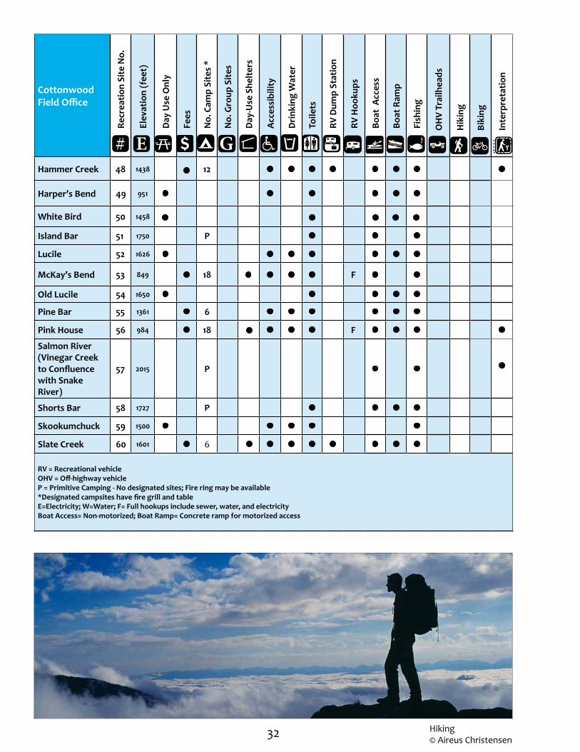
Cottonwood Field Office
Recr
eatio
n Si
te N
o.
Elev
atio
n (f
eet)
Day
Use
Onl
y
Fees
No.
Cam
p Si
tes
*
No.
Gro
up S
ites
Day
-Use
She
lter
s
Acc
essi
bilit
y
Dri
nkin
g W
ater
Toile
ts
RV D
ump
Stat
ion
RV H
ooku
ps
Boat
Acc
ess
Boat
Ram
p
Fish
ing
O
HV
Trai
lhea
ds
H
ikin
g
B
ikin
g
I
nter
pret
atio
n
Hammer Creek 48 1438 12
Harper’s Bend 49 951
White Bird 50 1458
Island Bar 51 1750 P
Lucile 52 1626
McKay’s Bend 53 849 18 F
Old Lucile 54 1650
Pine Bar 55 1361 6
Pink House 56 984 18 F
Salmon River (Vinegar Creek to Confluence with Snake River)
57 2015 P
Shorts Bar 58 1727 P
Skookumchuck 59 1500
Slate Creek 60 1601 6
RV = Recreational vehicleOHV = Off-highway vehicleP = Primitive Camping - No designated sites; Fire ring may be available *Designated campsites have fire grill and table E=Electricity; W=Water; F= Full hookups include sewer, water, and electricityBoat Access= Non-motorized; Boat Ramp= Concrete ramp for motorized access
E G#
Hiking© Aireus Christensen
33
M
iddle Fork Clearwat e r Ri ve
r
Gra
ve
Cre
ek R
d
Ce n ter Creek Rd
Canfield Rd
Pine Bar Rd
Old US Hwy 95
Frank Church-River of No Return Wilderness
!
!
!
!
!
!
!
!
!
!!
!
!!
! !
!!
!! !
!
!
!
! ! !!
! !!!
!
!
Fenn
Peck
Greer
Arrow
Stites
Winona
Kamiah
Mohler Pardee
Weippe
Lapwai
Pierce
Myrtle LenoreAgatha
Jaypee
Riggins
Lucille
Kooskia
Orofino
Ahsahka
Cardiff
Harpster
Culdesac
Spalding
Whitebird
Ferdinand
Nez PerceCraigmont
Cottonwood
Winchester
Sweetwater
Slate Creek
Grangeville
IDAHO
LEWIS
NEZ PERCE
CLEARWATER
LATAH
¬«14
¬«13
¬«162
¬«7
¬«3
¬«11
¬«64¬«62
£¤95
£¤12
£¤95
£¤95
£¤12
To New Meadows
To Lewiston
£¤95
£¤95
To Moscow
Dworshak Reservoir
Soldiers Meadow Reservoir
Lapwai LakeLake
Waha
Tolo Lake
Clearwater River
Sn
ake
Rive
r
Sa
lm
on
R iv er
Sou th F ork Clearwater River
Salmon
River
55
5048
59
60
5254
58 51
53 49 56
57
OR
EG
ON
WA
SH
ING
TO
N
O R E
W A S H
10 0 10
Miles
5
±

34
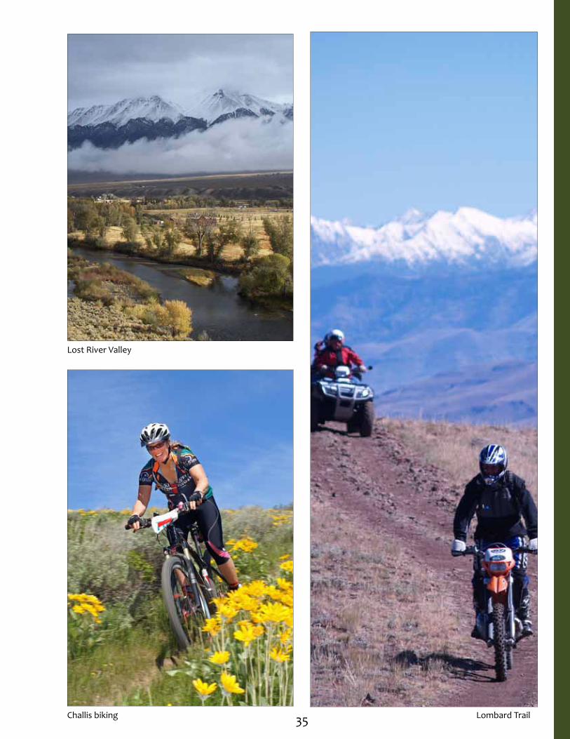
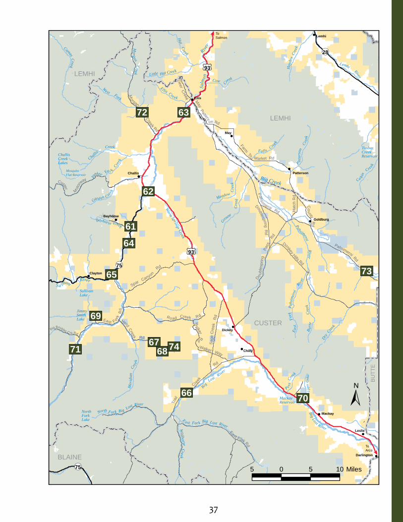
Eastern Idaho: Challis Field Office
This area’s remote and beautiful expanses of land, towering mountains and scenic rivers are the backdrop for a variety of outdoor recreation opportunities. Most recreation centers on the East Fork of the Salmon River, the Main Salmon River and the Big Lost River System. The clear waters of the Salmon River Canyon offer outstanding steelhead and trout fishing. Other opportunities include Class I and II boating, big game hunting, nature viewing and camping along the river.
The popular camping destination of Joe T. Fallini Campground (formerly Mackay Reservoir Recreation Site) is the only recreational site in the area that offers full RV hookups. This scenic site has gorgeous views of the Lost River Range and offers boating in the summer and ice fishing in late winter.
History buffs will enjoy a visit to the ghost town of Bayhorse or learn about the unique mining history of the White Knob Mining District, one of the largest copper producers in Idaho. Take the self-guided Mackay Mine Hill Auto Tour to discover more about the area’s past.
Hikers will enjoy exploring this spectacular area. The Lost River Access Trail includes a ¾- mile trail designed for maximum accessibility (grade and slope) from the trailhead down to the Big Lost River. For those interested in a more arduous hike paired with a spectacular view of Mt. Caleb, another ¾-mile hike is also available.
OHV riders will find a multitude of rides available in this area. These include the Jimmy Smith Trail, Pennal Gulch Trail, Bayhorse Mine Area, Snake Ridge Trail and the Lombard Trail.
Lost River Valley
Lost River Valley sheep
35
Lost River Valley
Lombard TrailChallis biking

36
Challis Field Office
Recr
eatio
n Si
te N
o.
Elev
atio
n (f
eet)
Day
Use
Onl
y
Fees
No.
Cam
p Si
tes
*
No.
Gro
up S
ites
Day
-Use
She
lter
s
Acc
essi
bilit
y
Dri
nkin
g W
ater
Toile
ts
RV D
ump
Stat
ion
RV H
ooku
ps
Boat
Acc
ess
Boat
Ram
p
Fish
ing
O
HV
Trai
lhea
ds
H
ikin
g
B
ikin
g
I
nter
pret
atio
n
Bayhorse 61 5150 11
Challis Bridge 62 5183
Cottonwood 63 4806 15
Deadman Hole 64 5216 5
East Fork 65 7155 10
Garden Creek 66 6745 5
Herd Lake Campsite 67 6981 1
Herd Lake Overlook 68 7198 P
Jimmy Smith Trailhead 69 6100 P
Joe T. Fallini at Mackay 70 6099 26 4 WE
Little Boulder 71 6200 3
Morgan Creek 72 5541 4
Summit Creek 73 6443 P
Upper Lake Creek 74 9090 2
RV = Recreational vehicle OHV = Off-highway vehicle P = Primitive Camping - No designated sites; Fire ring may be available *Designated campsites have fire grill and table E=Electricity; W=Water; F= Full hookups include sewer, water, and electricityBoat Access= Non-motorized; Boat Ramp= Concrete ramp for motorized access
E G#
Chilly Slough
37
Spar Canyon
Rd
Do
uble
sprin
g
Pas
s
Rd
Ro ad Creek R d
Walker Rd
Walker Way
Sag
e C
reek
R
d
T
rail
Cre
ek
Rd
Herd Creek Rd
Eas t Fork R
d
Big Boulder Crk Rd
Pahs imeroi Rd
Pahsimeroi Rd
Donkey Hills Rd
Doublespring Rd
Co
u nty Rd
Farm To Market Rd
May Patters
on Rd
East Fork Rd
Custer M
otor
way
Morgan C
reek Rd
Deer C
reek
Hat
ch R
d
!
!
!
!
!
!
!!
!
!
!
!
!
May
Ellis
Lemhi
Leslie
Mackay
Chilly
Dickey
Clayton
Challis
GoldburgBayhorse
Patterson
Darlington
CUSTER
LEMHI
LEMHI
BLAINE
BU
TTE
¬«75
¬«75
¬«28
£¤93
£¤93
To Arco
To Salmon
Big Creek
L emhi River
H
ayde
n C
reek
Cow Cr
eekLittle Hat Creek
Hat C
reek
El lis C
reek
Morgan Creek
Camas Creek
Salm
on
R
iver
C
hallis
Creek
Sa lmon
River
E ast Fork Big Lost River
Yankee F
o r k C
reek
Gard en C reek
North Fork Big Lost River
Wildho rse Creek
M
erid
ian
Cr
eek
Bi g
Lost R ive
r
Big Lost River
Upp
er C
edar
Dry
Creek
West Fork
P atte
rson
Cre
ek
Fa lls Cree
k
Pahsimeroi River
Ea
st
For
k
Pahs
imer
oi
River
B urn
t
Cr
eek
Grouse
C
reek
Meadow Cre
ek
C
a bin
Creek
Pe te C
reek
Sullivan Lake
Mosquito Flat Reservoir
Challis Creek Lakes
Timber Creek Reservoir
North Fork Lake
Mackay Reservoir
Bayhorse creek
JimmySmith Lake
Warm S prings Creek
±
5 0 5 10 Miles
61
62
63
64
65
66
6768
69
70
71
72
73
74

38
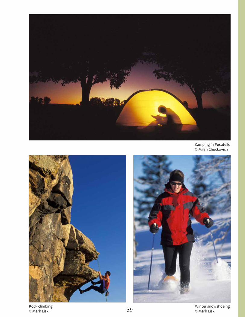
Eastern Idaho: Pocatello Field Office
Southeast Idaho landscape ranges from salt desert shrub to high elevation sub-alpine fir that supports unique plants and animals and provides an environment for different recreational opportunities. Visitors to this area will discover unique historical information and enjoy fishing, camping and off-highway vehicle (OHV) riding.
The Blackfoot River flows through a desert canyon of sagebrush and juniper habitat where visitors enjoy hiking and trout fishing. Anglers can set-up camp at one of five small campgrounds, lining the shores of the Blackfoot River. Wildlife viewers will enjoy the area’s nesting golden eagles, prairie falcons, red-tailed hawks and great horned owls.
A range of floating opportunities is available along the Blackfoot River for boaters of all experience levels. The 10-mile stretch of river from Blackfoot Dam to Cutthroat Creek Campground hosts primarily Class I rapids, with one Class II section. The section from Cutthroat Trout Campground to Trail Creek Bridge includes 12 miles of Class II rapids. More advanced boaters will enjoy the 12-mile stretch from Trail Creek Bridge to Cedar Creek (near Aldridge) that hosts Class III-IV or IV-V rapids, depending on water levels.
Other floating and fishing opportunities can be found on the Portneuf and Bear Rivers. Motorized and non-motorized boating and fishing can be found on the Snake River below American Falls Dam. The Blackfoot and Oneida Reservoirs host a large population of rainbow and cutthroat trout. A developed campground is located at each reservoir for avid fishermen and other water sports enthusiasts.
Visitors and local residents enjoy the convenience of outdoor adventures right in their backyard. Many recreation options can be found within an hour’s drive of Pocatello. On the edge of town, visitors can explore 40 miles of designated routes on foot, mountain bike or off-highway vehicle (OHV) at the Chinese Peak - Blackrock Trail System. All travel via motorized vehicles and mountain bikes is limited to designated routes and from November 16 – April 15, a seasonal closure is in effect to protect important mule deer winter range. Horse and foot traffic (hiking, snow shoeing and cross-country skiing) is welcome year-round during the winter months.
To experience the history and scenery of this region, drive the Pioneer Scenic Byway or the Bear Lake Caribou Scenic Byway, or hike along the Oregon/California National Historic Trail.
Biking in the Pocatello area
39
Camping in Pocatello© Milan Chuckovich
Rock climbing© Mark Lisk
Winter snowshoeing© Mark Lisk
40 Floating the Blackfoot River near Cutthroat Trout Campground
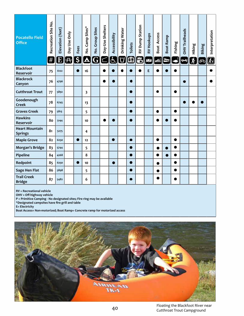
Pocatello Field Office
Recr
eatio
n Si
te N
o.
Elev
atio
n (f
eet)
Day
Use
Onl
y
Fees
No.
Cam
p Si
tes*
No.
Gro
up S
ites
Day
-Use
She
lter
s
Acc
essi
bilit
y
Dri
nkin
g W
ater
Toile
ts
RV D
ump
Stat
ion
RV H
ooku
ps
Boat
Acc
ess
Boat
Ram
p
Fish
ing
O
HV
Trai
lhea
ds
H
ikin
g
B
ikin
g
I
nter
pret
atio
n
Blackfoot Reservoir 75 6122 16 E
Blackrock Canyon 76 4796
Cutthroat Trout 77 5892 3
Goodenough Creek 78 6745 13
Graves Creek 79 5813 5
Hawkins Reservoir 80 5144 10
Heart Mountain Springs 81 5275 4
Maple Grove 82 6250 12
Morgan’s Bridge 83 5744 5
Pipeline 84 4268 8
Redpoint 85 6250 10
Sage Hen Flat 86 5898 5
Trail Creek Bridge 87 5482 6
RV = Recreational vehicleOHV = Off-highway vehicleP = Primitive Camping - No designated sites; Fire ring may be available *Designated campsites have fire grill and tableE= ElectricityBoat Access= Non-motorized; Boat Ramp= Concrete ramp for motorized access
E G#

41
Fort HallIndian
Reservation
Idaho NationalEngineering Laboratory
Wolverine R d
Lincolin C reek Rd
Grays Lake Rd
Mc Coy Cr eek Rd
Ross Fork Rd Gay M ine Rd
Pole Line Rd
Res
erva
ti on
Rd
Basin Rd
C
h est
erfi e
ld R
dCow
Camp Rd
Coral R
d Skin ny D
i p Rd
Topo
nce
Rd
Lun
d R
d
Blackfoot Res Rd
Goverment D
am Rd
North Access Rd
China Cap Rd
Bone Rd
Bone Rd
P ar
adise R d
Blackfoot Res Rd
Sho
rtcut Rd
Sunnyside Rd
Long Valley Rd
Ellis Rd
A rimo Rd
MarshCrk Rd
JensenRd
Hawkins Rd
N Beach Rd
E S
hore
Rd
Ding le E
Shore Rd
CottonwoodRd
Old Hwy 30
BINGHAM
CARIBOU
ONEIDA
POWER
BONNEVILLE
BANNOCK
FRANKLIN
BUTTE
JEFFERSONMADISON
TETON
BEAR LAKE
CA
SS
IA
¬«38
¬«40
¬«22
¬«43
¬«48
¬«39
¬«33
¬«37
¬«36
¬«36
¬«34
¬«31
¬«34
£¤30
£¤89
£¤20
£¤26
£¤20
£¤26
£¤91£¤26
To Arco
To Rexburg
To Afton
To Utah To
Utah
£¤30
£¤30£¤91
To
Wyo
min
g
§̈¦15
§̈¦15
§̈¦84
§̈¦15
§̈¦86
To Twin Falls
To Utah
To Twin Falls
To Dubois
To Utah
§̈¦15
Bear Creek
B la ckfoot Slug Cr eek Slug Creek
Lanes Creek
Big
Los
t R
iver
Sna
ke R
iver
Portneuf River
Snak
e
Riv
er
Blackfoot
R iver
Dee
p
Cree
k
Mald R
iver
Sn
ake
R
iver H
enrys
Frk
Snake Riv er
Be
ar
R ive
r
Be
ar
River
American Falls Reservoir
Bear Lake
Palisades Reservoir
Ririe Reservoir
Alexander Reservoir
Oneida Narrows Res
Daniels Reservoir
Grays Lake
NationalWildlifeRefuge
Glendale Reservoir
Mud Lake
Treasureton Res
Weston Creek Reservoir
Condie Res
Deep Creek Reservoir Twin Lakes
Reservoir
Packsaddle Lake
Gibson Lakes
Blackfoot River Rservo ir
Bear River
Bannock Creek
Roy
Gay
Ovid
Grays Lake
Rose
Bone
Iona
Ucon
Howe
Paris
Mound Valley
Niter
ArimoRobinGrace
InkomHatch
Henry
Tyhee
Wayan
Firth
OzoneIrwin
Ammon
Ririe
Rigby
Menan
Weston
Dayton
Banida
Sharon
Downey
Poplar
Shelley
Preston
Juniper
Liberty
Virgina
Michaud
Pingree
Liberty
Wapello
Kimball
Lincoln
Lorenzo
Roberts
Franklin
Holbrook
Wardboro
Swanlake
Thatcher
Rockland
Mccammon
Bancroft
Portneuf
ChubbuckAberdeen
Moreland
Scoville
Thornton
Riverdale
Pocatello
Fort Hall
Blackfoot
Riverside
Palisades
Sunnydell
Fish Haven
Malad City
Mink Creek
Bennington
Georgetown
Lewisville
St. Charles
Bloomington
Springfield
Atomic City
Swan ValleyIdaho Falls
Soda Springs
Chesterfield
Cerro Grande
American Falls
Lava Hot Springs
Montpelier
Grays Lake O
utlet
Willow
C ree k
!
!!
!
!!
!!
!!
!!
!! !
!
!
!
! !
! !
!
!!!
!!
!
!!! !
!
!
!
!
!
! !
!
! !
!
! !
!!
!
!
!
!!
!
! !!
!
!!
!
! !
!
! !!
!
!!!
!
!
!
!
!!
!!
!
!! !
!!
!
Rock Creek
U TA H
±
9 0 9 18
Miles
7576
77
78
79
80
8182
83
84
85
86
87

42
Eastern Idaho: Salmon Field Office
Spectacular scenery and great opportunities for adventure await visitors in this area. The Salmon River, “River of No Return,” provides world-class river rafting, camping, hiking, sight-seeing and wildlife viewing. The Salmon River, Bitterroot, and Lemhi ranges offer endless hiking, fishing, hunting and exploration opportunities.
Hikers and nature lovers will find scenic and rugged terrain in the isolated, often-overlooked Lemhi Range where elk, deer, mountain goats, moose and black bears are abundant.
The Salmon River meanders through the second-deepest gorge on the continent and is well-known as Idaho’s best steelhead fishing area, along with rainbow and cutthroat trout. Rafters will enjoy scenic floating and fishing along the calmer stretches of the river near the
town of Salmon, or tackle challenging whitewater (Class I-IV) on the stretch of river west of North Fork, Idaho.
The unspoiled 1.6-million acre Bitterroot Range and Continental Divide serve as Idaho’s eastern border. This area was visited by the Corps of Discovery’s Lewis and Clark in 1805. Today, visitors can stand on the Continental Divide National Scenic Trail and see the same expansive view that greeted the Corps of Discovery.
The Bitterroot Range is home to a variety of wildlife and offers spectacular trails for mountain biking and hiking. This is also the ultimate terrain for rock climbing, hunting and fishing excursions.
Birch Creek© James Neeley

43
Pirimids recreation site
Tower Rock recreation site

44
Salmon Field Office
Recr
eatio
n Si
te N
o.
Elev
atio
n (f
eet)
Day
Use
Onl
y
Fees
No.
Cam
p Si
tes*
No.
Gro
up S
ites
Day
-Use
She
lter
s
Acc
essi
bilit
y
Dri
nkin
g W
ater
Toile
ts
RV D
ump
Stat
ion
RV
Hoo
kups
Boat
Acc
ess
Boat
Ram
p
Fish
ing
O
HV
Trai
lhea
ds
H
ikin
g
B
ikin
g
I
nter
pret
atio
n
Agency Creek 88 5663 P
Discovery Hill 89 4222
Eight Mile 90 4094
Eleven Mile 91 4143
Goldbug Hot Springs 92 4796
Kilpatrick 93 4445 P
McFarland 94 5374 5
Morgan Bar 95 3838 7
Sharkey Hot Springs 96 5272
Shoup Bridge 97 4032 5
Smokey Cubs 98 6269 7 1
Tower Creek Pyramids 99 4143
Tower Rock 100 3789 5 1
Williams Lake 101 5708 7 RV = Recreational vehicleOHV = Off-highway vehicleP = Primitive Camping - No designated sites; Fire ring may be available *Designated campsites have fire grill and tableBoat Access= Non-motorized; Boat Ramp= Concrete ramp for motorized access
E G#
Steelhead salmon fishing

45
Willam s Creek
!
!
!
!
!
!
!
!
!
May
Ellis
Lemhi
Baker
Tendoy
Salmon
Carmen
Leadore
North Fork
Lee Creek Rd
Cotto m L
n
Old Hwy 28Lee
Cre
ek R
d
Deep Creek Rd
May P
atter son
Rd
Doublespring Rd
Hay
den
Creek
Rd
Basi n Creek Rd
Warm
Sp rin
gs Wood Rd
Agen cy
Cree
k Rd
Old H
wy 28
Back R
d
Old L emhi Rd
Carmen Creek R
d
NF-021
Iron Creek Rd
NF-030
Freeman Creek RdNF-0
23
NF - 129
NF-028
NF-014
NF-027
LEMHI
CUSTER
¬«29
¬«28
£¤93
£¤93
To Arco
To Montana
N F
ork
Salm
o n
Salmo n R
iver Fourth
of J
uly C
reek
Littl
e Fo
urth
of
Jul y C
reek
Diamon d Cre ek
Fenst er C re ek
C
armen
Cree
k
Freema n Creek
He nry Cre ek
Lemhi River
Lake Creek WillamsLake
Boh
anno
n
C
reek
Wim
pey
C
ree
k
Pra
tt
Cree
k
Sandy C
reekKenney
C
ree k
Patte e
C
reek
A
gency Creek
Cow C ree k
Yea rian
Cre
ek
South
Fork
R eese C
reek
Litt
le Eightm
ile C
reek
Canyon C
reek
B
ig E
ight
mile
C
reek
Mill
C
reek
Le
e
C
reek
Hay
den
Creek
Bear Creek
Cow Cree
k
Ellis Creek
Little
Ha
t Creek
Hat Creek Poison Creek
Iron Creek
Ringle Cre ek
McKim Creek
W
ar
m Spring Creek
Haynes C reek
McDevitt Creek
Deer Creek
Rattlesn ake Creek
Sa
l mon
R
ive
r
Within gton Creek
Twelvemile Cre ek
Lemhi River
East
For
k
Ea st
F
ork
Towe
r C
reek
Wallace C
reek
Bear Valley Lakes
Basin Lake
Big
Tim
ber
Cre
ek
Basin Creek
±
4 0 4 8 Miles
MO
NTAN
A
MO
NTAN
A
99100
101
98
97
96
95
9493
92
9190
89
88

46
Eastern Idaho: Upper Snake Field Office
Whether fishing or floating the internationally-renowned South Fork of the Snake River, taking an exhilarating buggy ride on the St. Anthony Sand Dunes, or a quiet stroll on the Cress Creek Nature trail, visitors will find an impressive variety of recreational activities for enthusiasts of all ability levels.
The St. Anthony Sand Dunes is the largest tract of sand dunes in Idaho, covering approximately 175 square miles. This 10,000-acre off-highway vehicle (OHV) playground offers dunes ranging from 50 to 400 feet in height. Exploration of this area’s sandy grounds can also be done on foot or horseback. Adjacent Egin Lakes Campground offers facilities for overnight guests. This popular dune-riding destination is also home to large populations of wintering elk, deer and moose.
The majestic South Fork of the Snake River flows for 66 miles through high mountain valleys, rugged canyons, and broad flood plains. This section of the Snake River supports the largest riparian cottonwood gallery forest in the West and is among the most unique and diverse ecosystems in Idaho. It is a birdwatching
paradise that is home to 126 bird species, including 21 raptors (birds of prey) and is designated as a National Important Bird Area. The river also supports the largest native cutthroat fishery outside of Yellowstone National Park. The South Fork is known throughout the country as a premier blue ribbon trout fishery, and was selected as the host site for the 1997 World Fly-Fishing Championship. Multiple access points are available to float the South Fork. Take your own boat or go with a guide. To get a bird’s eye view of the South Fork of the Snake River, take a stroll along the beautiful 1¼-mile Cress Creek Nature Trail.
To discover more about the area’s environment, try one of the four interpretive trails. Each trail system incorporates educational information along the trail route. Visitors can learn about the geology, recreation opportunities, local plant communities and common wildlife species viewed in that area.
Hikers will also enjoy challenging ascents through this area’s geologic past. Big Southern Butte is one of the largest volcanic domes in the world, yet is one of the youngest (300,000 years old). Hikers who trek to the top of this 7,550-foot high summit will be rewarded with spectacular panoramic views stretching for miles. The Hell’s Half Acre lava trail crosses the Snake River Plain desert through the rough terrain and contorted landscapes created by multiple lava flows. This flow is the most recent in eastern Idaho, having erupted about 4,100 years ago.
South Fork of the Snake RiverFishing near the South Fork of the Snake River

47
South Fork of the Snake River © Mark Lisk
St. Anthony Sand Dunes© Duneratt, LLC
South Fork of the Snake River © Mark Lisk
48
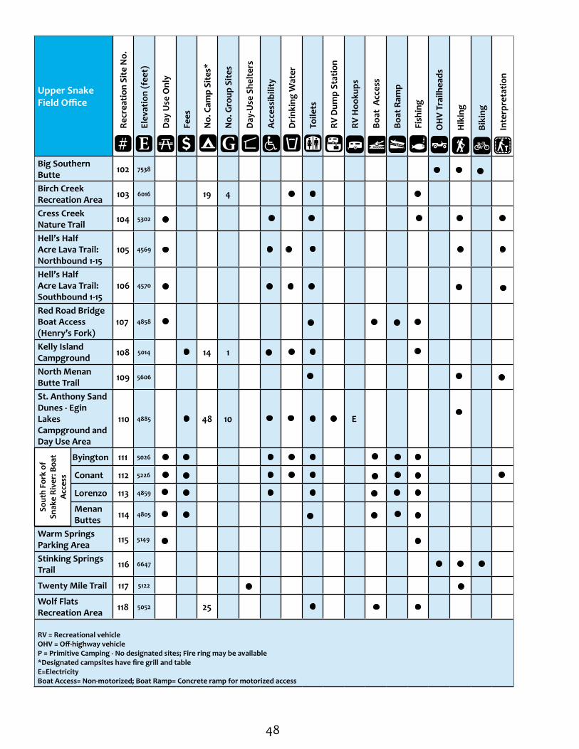
Upper Snake Field Office
Recr
eatio
n Si
te N
o.
Elev
atio
n (f
eet)
Day
Use
Onl
y
Fees
No.
Cam
p Si
tes*
No.
Gro
up S
ites
Day
-Use
She
lter
s
Acc
essi
bilit
y
Dri
nkin
g W
ater
Toile
ts
RV D
ump
Stat
ion
RV H
ooku
ps
Boat
Acc
ess
Boat
Ram
p
Fish
ing
O
HV
Trai
lhea
ds
H
ikin
g
B
ikin
g
I
nter
pret
atio
n
Big Southern Butte 102 7538
Birch Creek Recreation Area 103 6016 19 4
Cress Creek Nature Trail 104 5302
Hell’s Half Acre Lava Trail: Northbound 1-15
105 4569
Hell’s Half Acre Lava Trail: Southbound 1-15
106 4570
Red Road Bridge Boat Access (Henry’s Fork)
107 4858
Kelly Island Campground 108 5014 14 1
North Menan Butte Trail 109 5606
St. Anthony Sand Dunes - Egin Lakes Campground and Day Use Area
110 4885 48 10 E
Byington 111 5026
Conant 112 5226
Lorenzo 113 4859
Menan Buttes 114 4805
Warm Springs Parking Area 115 5149
Stinking Springs Trail 116 6647
Twenty Mile Trail 117 5122
Wolf Flats Recreation Area 118 5052 25
RV = Recreational vehicleOHV = Off-highway vehicleP = Primitive Camping - No designated sites; Fire ring may be available *Designated campsites have fire grill and table E=ElectricityBoat Access= Non-motorized; Boat Ramp= Concrete ramp for motorized access
E G#
Sout
h Fo
rk o
f Sn
ake
Rive
r: B
oat
Acc
ess

49
Henrys Fork East Camas Creek
Ch ing Creek
West Camas Creek
Beaver C reek
War
m
Rive
r
Conant Creek
Fa ll Cree k
Willo w Creek
Gr ays Lake Outlet
Blackfoo t R
iver
D
uboi
s-Kilgore R
d
Red R
d
Yale-Kilgo re Rd
Idmon Rd
600 N St
Sunnyside R
d
Bone Rd
Keeps Crossing Rd Fall s C reek
Rd
600 N St
Taber Rd
Spr
ingf
ield
-Tab
er
Rd
Section R
d
Rose
Iona
Ucon
Howe
Teton
Henry
Tyhee
Wayan
FirthTaber
Irwin
Ammon
Ririe
Rigby
Menan
Hamer
Camas
Idmon
Basalt
Dehlin
Poplar
Parker
Ashton
Dubois
Shelley
Pingree
Liberty
WapelloKimball
Roberts
Rexburg
Newdale
Chester
Winsper
Spencer
Kilgore
ChubbuckAberdeen
Moreland
Thornton
Mud Lake
Terreton
Humphrey
Pocatello
Fort Hall
BlackfootRiverside
Sunnydell
Macks Inn
Lewisville
Warm River
Springfield
Atomic City
Swan Valley
Idaho Falls
St. Anthony
Island Park
Cerro Grande
Sage Junction
Lorenzo
Clementsville
To Malad City
CLARK
BINGHAM
FREMONT
BONNEVILLE
BUTTE
JEFFERSON
CARIBOU
MADISON
BANNOCK
TETON
LEMHI
POWER
BLA
INE
Fort HallIndian
Reservation
Idaho National
Engineering
Laboratory
¬«28
¬«33
¬«31
¬«48
¬«33
¬«22
¬«32
¬«33
¬«47
¬«34
¬«39
¬«43
£¤20
£¤30
£¤26
£¤20
£¤20
£¤26 £¤91
£¤26To Arco
§̈¦15
§̈¦15
§̈¦15
§̈¦86To American Falls
Medicine Lodge Creek
Birch Creek
Camas Creek
S nake
Ri v
er
Snake River
Hen
rys F
ork
American Falls Reservoir
Blackfoot River
Reservoir
Mud Lake
Island Park
Reservoir
Ririe Reservoir
Chesterfield Reservoir
Sheridan Reservoir
Little Valley Reservoir
Ashton Reservoir
Silver Lake
Two-Way Pond
Chester Reservoir
Grays LakeNational WildlifeRefuge
Teton Rive r
Henrys Lake
M O N TA N A
115
108104
112
111 116118
105106
117
113109114
107110
102
103
!
!
!
!
!
! !
!!
!
!
!
!
!
!!
!
!!
!
!!
!
!!!
!!
!
!
!
!!
!!
!
!
!
!!
! !! !
!!
!
! !
! !
!
!!
!
!!
!
!
!
!
!
To Butte, Mont
To Three Forks, Mont
±
8 0 8 164 Miles

50
Central Idaho: Burley Field Office
This area’s basalt cliffs and grasslands offer outstanding hunting for upland game birds and antelope, while a local reservoir provides plenty of fishing opportunities for visiting anglers.
Water activities in this region are popular during warm and cold weather. During warm months, anglers flock to Lud Drexler Park in search of abundant brown trout, kokanee salmon, yellow perch, black crappie, chinook salmon, channel catfish, small mouth bass and walleye. In January and Feburary, visitors often arrive to ice fish at the Salmon Falls Creek Reservoir.
The Cotterel Mountains provide wonderful, peaceful hiking opportunities with scenic vistas. Hikers can also combine their love of the outdoors with a cultural learning experience at Milner Historic Recreation Area. Deep ruts are still visible here, remnants of the Oregon Trail emigrants who passed through this area over 100 years ago. Just north of the west entrance to Milner, an interpretive shelter and hiking trail leads to the ruts.
For those interested in wildlife viewing, take a trip to the Rock Creek Canyon - Shoshone Basin area. The paved roads travel through a steep, rock-walled canyon along Rock Creek, where you might see mallards, teal or mule deer on their winter range (December through February). In May through October, look for birds that call this area home including yellow warbler, American goldfinch, brown-headed cowbird, belted kingfisher and northern flicker.
Nearby Electric Spring is a 25-acre marsh, fenced to protect nesting waterfowl and wading birds. Look for the interpretive signs and keep an eye out for geese and ducks on the nesting islands. Visitors heading west from the marsh into the sagebrush flatlands of the Basin may catch a glimpse of pronghorn and sage-grouse. The area also has numerous campgrounds and hiking trails.
For the skiing enthusiast, the Magic Mountain area has several cross-country ski trails available. Occasionally a porcupine, longtailed weasel, or Steller’s or gray jay may be seen on explorations in the backcountry.
Castle Rocks
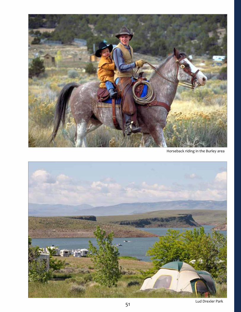
51 Lud Drexler Park
Horseback riding in the Burley area

52
Burley Field Office
Recr
eatio
n Si
te N
o.
Elev
atio
n (f
eet)
Day
Use
Onl
y
Fees
No.
Cam
p Si
tes*
No.
Gro
up S
ites
Day
-Use
She
lter
s
Acc
essi
bilit
y
Dri
nkin
g W
ater
Toile
ts
RV D
ump
Stat
ion
RV H
ooku
ps
Boat
Acc
ess
Boat
Ram
p
Fish
ing
O
HV
Trai
lhea
ds
H
ikin
g
B
ikin
g
I
nter
pret
atio
n
Lud Drexler Park 119 5045 20
McClendon Spring Campground
120 4839 P
Milner Historic Recreation Area 121 4153 20
Snake River Vista 122 4438 2 RV = Recreational vehicleOHV = Off-highway vehicleP = Primitive Camping - No designated sites; Fire rings may be available *Designated campsites have fire grill and tableBoat Access= Non-motorized; Boat Ramp= Concrete ramp for motorized access
E G#
Hunting in the Burley area© Glenn Oakley

53
H ig h Line Canal Low Line Can al Dese rt Creek
N. C
otto
nwoo
d C re
ek
Cottonwood Creek
Goo
se
Cre
ek
Co ld
Creek
Marsh Creek
Raft R
iver
Bi g Wo od Riv er
Little Wood River
A
lmo
R
d
Narrows R
d
To IdahoFalls
To Fairfield
To Buhl
200
0 St
Can
al
R
d
2500 St
2200 St
ThreeCreek Rd Birch Creek Rd
Basin Rd Elba Rd
Junction Valley Rd L
y nn
Rd
Ely Rd
Goose
Cr e
ek
Rd
Gannett Pic abo Rd
Shal
e Butte Rd
Kim
ama
Car
ey
Rd
Kim
ama
Car
ey R
d
Laidla
w P
ark R
d
A
rco M
inid
oka
R
d
Bear Trap Cave R d
Giff
ord
Spring Rd
Old Hwy 81
CASSIA
BLAINE
LINCOLN
BUTTE
TWIN FALLS
POWER
MINIDOKAJEROME
CAMAS
GOODING
BIN
GH
AM
CUSTER
ON
EID
A
!!
!
!
!
!
! ! !
! !!
! !
!
!!
!
!
! !!
! !
!!
!!
!!!
!
!
!
! !
!
!!
!!
!
!! !
!
!
! !
!
!
Almo
Elba
Paul
Eden
Arco
Basin
Malta
Declo
Filer
Carey
Bridge
Oakley
Locust
ConantConner
Albion
Berger
Hansen Burley
Rupert
Jerome
Kimama
Owinza
Picabo
Hailey
Gimlet
Idavada Moulton
Juniper
Idahome
Acequia
Wendell
Gooding
Rogerson
Kimberly
Hazelton
Minidoka
Dietrich
Shoshone
Bellevue
Amsterdam
Hollister
Richfield
Springdale
Twin Falls
Magic City
Butte City
Murtaugh
American Falls
Rockland
Gannett
¬«46
¬«75
¬«25
¬«39
¬«37
¬«77¬«81¬«27
¬«27
¬«24
¬«24
¬«74¬«50
¬«25
¬«33
£¤93
£¤93
£¤93
£¤30
£¤30
£¤20
£¤26
£¤26£¤20
£¤26
To Nevada
§̈¦84
§̈¦86
§̈¦84
To Utah
To GlennsFerry
Big Los t River
Magic Res
Salmon Falls Creek Res
Lower Goose Creek Res
Murtaugh Lake
Little Wood River Res
Wilson Lake Res
Fish Creek Res
Campbell Res
Deep Creek Res
Mc Han Res
Lava Lake
Big Wood River Lake
Goose Lake
Blue Lakes
Star Lake
Wheatly Pond
Lake Walcott
Snake River
Snake RiverM ilner L ak
e
Carey Lake
Independence Lakes
Lake Cleveland
To American
Falls
City of RocksNational Reserve
Cratersof theMoon
National Monument
Idaho National
Engineering Laboratory
N E VA D A U TA H
120
122
121
119
±7 0 7 14 Miles
54
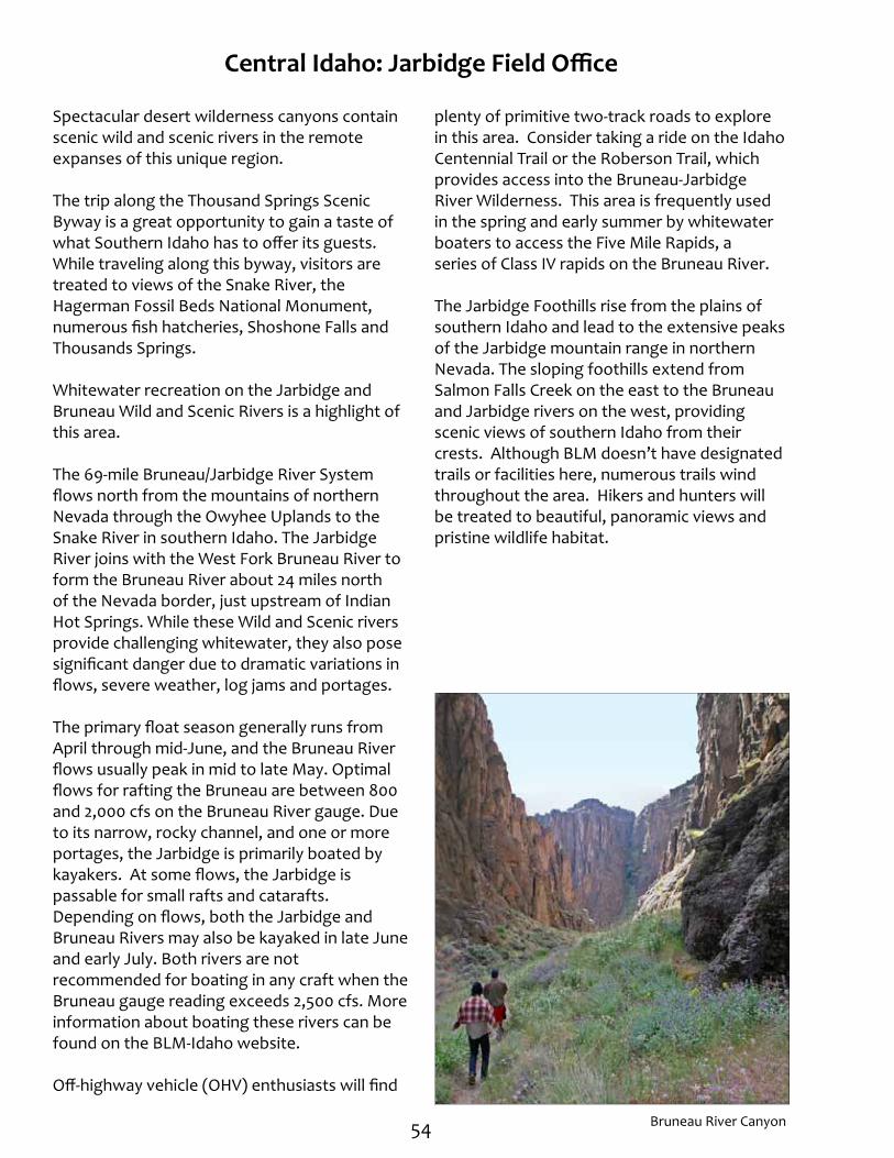
Central Idaho: Jarbidge Field Office
Spectacular desert wilderness canyons contain scenic wild and scenic rivers in the remote expanses of this unique region.
The trip along the Thousand Springs Scenic Byway is a great opportunity to gain a taste of what Southern Idaho has to offer its guests. While traveling along this byway, visitors are treated to views of the Snake River, the Hagerman Fossil Beds National Monument, numerous fish hatcheries, Shoshone Falls and Thousands Springs.
Whitewater recreation on the Jarbidge and Bruneau Wild and Scenic Rivers is a highlight of this area.
The 69-mile Bruneau/Jarbidge River System flows north from the mountains of northern Nevada through the Owyhee Uplands to the Snake River in southern Idaho. The Jarbidge River joins with the West Fork Bruneau River to form the Bruneau River about 24 miles north of the Nevada border, just upstream of Indian Hot Springs. While these Wild and Scenic rivers provide challenging whitewater, they also pose significant danger due to dramatic variations in flows, severe weather, log jams and portages.
The primary float season generally runs from April through mid-June, and the Bruneau River flows usually peak in mid to late May. Optimal flows for rafting the Bruneau are between 800 and 2,000 cfs on the Bruneau River gauge. Due to its narrow, rocky channel, and one or more portages, the Jarbidge is primarily boated by kayakers. At some flows, the Jarbidge is passable for small rafts and catarafts. Depending on flows, both the Jarbidge and Bruneau Rivers may also be kayaked in late June and early July. Both rivers are not recommended for boating in any craft when the Bruneau gauge reading exceeds 2,500 cfs. More information about boating these rivers can be found on the BLM-Idaho website.
Off-highway vehicle (OHV) enthusiasts will find
plenty of primitive two-track roads to explore in this area. Consider taking a ride on the Idaho Centennial Trail or the Roberson Trail, which provides access into the Bruneau-Jarbidge River Wilderness. This area is frequently used in the spring and early summer by whitewater boaters to access the Five Mile Rapids, a series of Class IV rapids on the Bruneau River.
The Jarbidge Foothills rise from the plains of southern Idaho and lead to the extensive peaks of the Jarbidge mountain range in northern Nevada. The sloping foothills extend from Salmon Falls Creek on the east to the Bruneau and Jarbidge rivers on the west, providing scenic views of southern Idaho from their crests. Although BLM doesn’t have designated trails or facilities here, numerous trails wind throughout the area. Hikers and hunters will be treated to beautiful, panoramic views and pristine wildlife habitat.
Bruneau River Canyon

55
Bruneau River Canyon© Leland Howard

56
Jarbidge Field Office
Recr
eatio
n Si
te N
o.
Elev
atio
n (f
eet)
Day
Use
Onl
y
Fees
No.
Cam
p Si
tes*
No.
Gro
up S
ites
Day
-Use
She
lter
s
Acc
essi
bilit
y
Dri
nkin
g W
ater
Toile
ts
RV D
ump
Stat
ion
RV H
ooku
ps
Boat
Acc
ess
Boat
Ram
p
Fish
ing
O
HV
Trai
lhea
ds
H
ikin
g
B
ikin
g
I
nter
pret
atio
n
Big Cottonwood 123 5150 4
Bruneau Canyon Overlook 124 3612
Bruneau River Launch Site 125 3687
Bruneau River Take-Out 126 2618
Cedar Creek Reservoir 127 5226
Idaho Centennial Road/Trail 128 3620
Jarbidge River Launch Site 129 5032 3
Juniper Grove 130 5183 4
The Forks 131 5050 4 RV = Recreational vehicleOHV = Off-highway vehicle*Designated campsites have fire grill and tableBoat Access= Non-motorized; Boat Ramp= Concrete ramp for motorized access
E G#
Jarbidge Wild and Scenic River
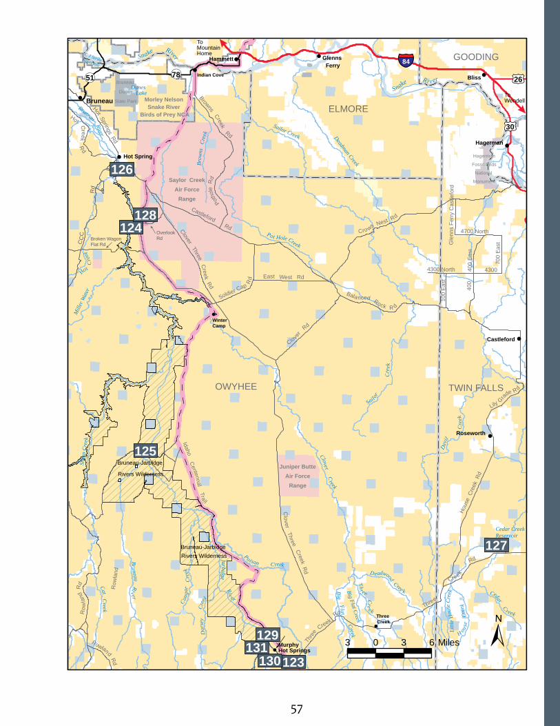
57
Idaho Centennal Tra i l
£¤30
£¤26§̈¦84
Bliss
Bruneau
Hammett
Hagerman
Roseworth
Castleford
Hot Spring
Three Creek
Winter Camp
Indian Cove
Glenns Ferry
Murphy Hot Springs
400
400
Eas
t
100
Eas
t
4300
Gle
nns
Ferr
y C
astle
ford
4300 North
Row
land
Cro ws Nest Rd
Balanced Rock R d
Clover
Rd
Clover Three Creek Rd
Clover Three Creek R
d
Ho
use
Cre
ek R
d
Lily G
rade Rd
East West Rd
Soldier Cap Rd
Pot
hole
Rd
Browns Creek Rd
Hot Springs Rd
Hot Cr eek R
d
Ro w
land
Rd
Rowlan d Rd
Broken WagonFlat Rd C
CC
Rd
OWYHEE TWIN FALLS
ELMORE
GOODING
4700 North
700
Eas
t
Castleford Rd
Three
Creek
R
d
Thr
ee
Creek
Rd
Overlook Rd
¬«78¬«51
To Wendell
To MountainHome
Bruneau-Jarbidge
Rivers Wilderness
Bruneau-Jarbidge Rivers Wilderness
Sailor Creek
Shee
p Cr
eek
Deadman Creek
Mill
er W
ater
Big Flat Creek
Bruneau Riv er
Cat Creek
C ouga
r C
reek
D
orse
y
Cre
ek
Jarbi dge Riv
er
Po ison C reek
Ceda r C reek
D eadwood Cree k Th
r ee Cre
ek
Big Fla t Creek
H
ouse
Cr
eek
Littl
e H
ouse
Cre
ek D
evil
C
reek
Clover Creek
Sail or
C
reek
Bruneau River
Pot Hole Creek
Brow
ns
Cree
k
Ho t C
reek
Cedar Creek Reservoir
C J Strike Reservoir
Dunes Lake
Snake Ri v er
Snake River
Morley Nelson Snake River
Birds of Prey NCA
Bruneau
Dunes
State Park
Saylor CreekAir Force
Range
Hagerman
Fossil Beds
National
Monument
Juniper ButteAir Force
Range
±3 0 3 6 Miles
125
126
124
127
128
123130131
129!
!
!
!
!
!
!
!
!!
!!
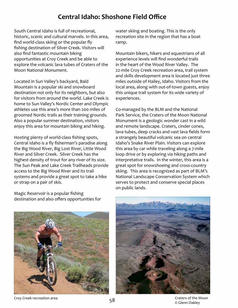
58
Central Idaho: Shoshone Field Office
South Central Idaho is full of recreational, historic, scenic and cultural marvels. In this area, find world-class skiing or the popular fly fishing destination of Silver Creek. Visitors will also find fantastic mountain biking opportunities at Croy Creek and be able to explore the volcanic lava tubes of Craters of the Moon National Monument.
Located in Sun Valley’s backyard, Bald Mountain is a popular ski and snowboard destination not only for its neighbors, but also for visitors from around the world. Lake Creek is home to Sun Valley’s Nordic Center and Olympic athletes use this area’s more than 200 miles of groomed Nordic trails as their training grounds. Also a popular summer destination, visitors enjoy this area for mountain biking and hiking.
Hosting plenty of world-class fishing spots, Central Idaho is a fly fisherman’s paradise along the Big Wood River, Big Lost River, Little Wood River and Silver Creek. Silver Creek has the highest density of trout for any river of its size. The Sun Peak and Lake Creek Trailheads provide access to the Big Wood River and its trail systems and provide a great spot to take a hike or strap on a pair of skis.
Magic Reservoir is a popular fishing destination and also offers opportunities for
Craters of the Moon© Glenn Oakley
water skiing and boating. This is the only recreation site in the region that has a boat ramp.
Mountain bikers, hikers and equestrians of all experience levels will find wonderful trails in the heart of the Wood River Valley. The 22-mile Croy Creek recreation area, trail system and skills development area is located just three miles outside of Hailey, Idaho. Visitors from the local area, along with out-of-town guests, enjoy this unique trail system for its wide variety of experiences.
Co-managed by the BLM and the National Park Service, the Craters of the Moon National Monument is a geologic wonder cast in a wild and remote landscape. Craters, cinder cones, lava tubes, deep cracks and vast lava fields form a strangely beautiful volcanic sea on central Idaho’s Snake River Plain. Visitors can explore this area by car while traveling along a 7-mile loop drive or by exploring via hiking paths and interpretative trails. In the winter, this area is a great spot for snowshoeing and cross-country skiing. This area is recognized as part of BLM’s National Landscape Conservation System which serves to protect and conserve special places on public lands.
Croy Creek recreation area
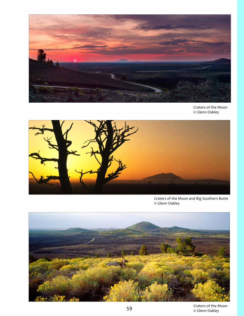
59
Craters of the Moon© Glenn Oakley
Craters of the Moon© Glenn Oakley
Craters of the Moon and Big Southern Butte © Glenn Oakley

60 Bald Mountain
Shoshone Field Office
Recr
eatio
n Si
te N
o.
Elev
atio
n (f
eet)
Day
Use
Onl
y
Fees
No.
Cam
p Si
tes*
No.
Gro
up S
ites
Day
-Use
She
lter
s
Acc
essi
bilit
y
Dri
nkin
g W
ater
Toile
ts
RV D
ump
Stat
ion
RV H
ooku
ps
Boat
Acc
ess
Boat
Ram
p
Fish
ing
O
HV
Trai
lhea
ds
H
ikin
g
B
ikin
g
I
nter
pret
atio
n
Croy Creek Recreation Area and Trailhead
132 5702
Fish Creek Reservoir 133 5360 1
Gooding/Camas County Line 134 5554
Magic Reservoir 135 4816 P
Lake Creek Trailhead 136 5974
Murtaugh Boating Access 137 3822
Silver Creek (North and South)
138
4714 4698 3
Sun Peak Picnic Area 139 5898 1
Thorn Creek Reservoir 140 5541 P
RV = Recreational vehicleOHV = Off-highway vehicleP = Primitive Camping - No designated sites; Fire ring may be available *Designated campsites have fire grill and tableBoat Access= Non-motorized; Boat Ramp= Concrete ramp for motorized access
E G#

61
East F
ork Wood River
Cratersof theMoon
National Monument
Shal
e Butte Rd
Kim
ama
Car
ey
Rd
Kim
ama
Car
ey R
d
Laidla
w P
ark R
d
Gannett Picabo Rd
Thorn Creek Desert Rd
Westside Magic Rd
West Magic Rd
Buhl PaulEden
Declo
Filer
Carey
Berger
Hansen Burley
Rupert
Jerome
Kimama
Tuttle
Owinza
Picabo
Hailey
Gimlet
Heyburn
Acequia
Wendell
Gooding
Gannett
Ketchum
Murtaugh
Kimberly
Hazelton
Hagerman
Dietrich
Shoshone
Bellevue
Richfield
Fairfield
Springdale
Twin Falls
Magic City
Sun Valley
BLAINE
LINCOLN
CAMAS
JEROME
GOODING
TWIN FALLS
CASSIA
CUSTER
BUTTE
MINIDOKA
Little Wood River
Big Wood River
Li
ttle
Woo
d Ri
ver
¬«46
¬«25
¬«25
¬«27
¬«27
¬«77
¬«81
¬«24
¬«75
¬«24
¬«74
£¤93
£¤20
£¤30
£¤26
£¤30
£¤26£¤93
£¤20
£¤93
To Nevada
To MountainHome
To Arco
To MountainHome
§̈¦84
§̈¦84
To GlennsFerry
Antelope
Creek
H igh Line Can al
Low Line C
anal
Dry
C
reek
Fou
rmile
Cre
ek
Lava Creek
Big
Woo
d Ri
v er
W
arm
Springs Cree
k
Deer Creek
Big
Smoky Cre
ek
Mul d
oon
Cree
k
Murtaugh Lake
Mormon Reservoir
Little Wood River Res Fish
Creek Res
Bray Lake
Campbell Res
Kelly Res
Mc Han Res
Lava Lake
Huff LakeMacon
Lake
Clear Lakes
Baker Lake
Star Lake
Snake River
Snake Ri ver
Wilson Lake Res
Blue Lakes
Goose Lake
M
ilner Lake
Big Wood River Lake
Magic Res
Camas Creek
Soldier Creek
Ind
ian C re ek
Littl
e W
ood
Riv
er
Fish Creek
To Utah
±
7 0 7 14Miles
137
140134
135 138
133
132
136139
Rock
Cre
ek R
d
Croy
Creek Rd
Co
Line
Rd
Priest RdCutoff Rd
Fish CreekReservoir Rd
!
!
! !!
! !
!!!
!! !!
!
!
!
!
!
!
!
!
!
!!
!
!
! !
!
!
!
!
!
!
!

This page is left blank

U.S. Department of the InteriorBureau of Land Management
Idaho State Office 1387 S. Vinnell Way
Boise, ID 83709(208) 373-4000
http://www.blm.gov/idwww.facebook.com/blmidahowww.youtube.com/blmidaho www.twitter.com/blmidaho


