BLOODVEIN RIVER A Canadian Heritage River Ten-year Monitoring Report: 2008 – 2018 Prepared by Manitoba Conservation and Climate Parks and Protected Spaces Branch with Ontario Parks, The Ministry of the Environment, Conservation and Parks for The Canadian Heritage Rivers System June 2020
Transcript
BLOODVEIN RIVERA Canadian Heritage River
Ten-year Monitoring Report: 2008 – 2018
Prepared by
Manitoba Conservation and Climate Parks and Protected Spaces Branch with
Ontario Parks, The Ministry of the Environment, Conservation and Parks
for
The Canadian Heritage Rivers System June 2020
AcknowledgementsThis report was prepared with contributions from numerous individuals and organizations including but not limited to:
• Sung Joon Kim, Mark Lee, and Tara Wiess, Manitoba Sustainable Development Water Science & Watershed Management Section
• Daniel Rheault, Manitoba Sustainable Development Water Quality Management Section
• Bloodvein River, Little Grand Rapids, Pikangikum and Lac Seul First Nations, who conducted a review of this report and/or collaborated on past research projects that contributed to information included in this report
• The Pimachiowin Aki Corporation
• The Manitoba Métis Federation
• Jill Taylor-Hollings, Department of Anthropology, Lakehead University.
Bloodvein River : A Canadian Heritage River | i
EXECUTIVE SUMMARYThe Bloodvein River is part of a network of rivers and lakes across northern Manitoba and Ontario, which were created by glaciers scouring the earth as they receded over 11,000 years ago. Indigenous Peoples have been living along the river corridor for thousands of years and today it flows through the Anishinaabe traditional territories of Lac Seul, Pikangikum, Little Grand Rapids, and Bloodvein River First Nations. On the basis of its strong natural and human heritage values, the western (Manitoba) portion of the Bloodvein was nominated to the Canadian Heritage Rivers System (CHRS) in 1984 and the eastern (Ontario) portion nominated in 1986. The CHRS requires that a detailed monitoring report be prepared every 10 years from designation to confirm that rivers continue to possess the natural, cultural and recreational values for which they were designated.
This 10-year monitoring report lists activities, events and research that occurred on the Bloodvein River since the last 10-year monitoring report was published in 2007, through to the end of 2018. It describes any changes or threats to the river’s natural heritage values, cultural heritage values, recreational values and CHRS integrity values. The management actions recommended by the management plans for the river are reviewed and their degree of achievement assessed. Lastly, benefits of CHRS designation are described.
Several important events and activities have taken place along the Bloodvein River over the past decade. Manitoba and Ontario agreed to work together to maintain the national significance of the river through the designation of Canada’s first Interprovincial Wilderness Area. The river also flows through Pimachiowin Aki, a 29,040-square-kilometre Indigenous cultural landscape designated as a UNESCO World Heritage Site in 2018. In addition, a new, all-weather road that crosses the Bloodvein was completed in 2014, providing road access to Bloodvein River First Nation and beyond. The construction of this road and bridge over the Bloodvein in Manitoba was a significant event that improved access to the west end of the river corridor, but also increased the potential for negative impacts such as littering and boat caching. It will be important that monitoring be conducted
to help prevent such issues from developing in the area.
Various research and monitoring projects were conducted in the Bloodvein River corridor between 2008-2018. These include aerial population surveys, radio collaring of caribou and wolves, and recruitment and population surveys for caribou and moose. Archaeological research carried out along the Bloodvein also discovered over 100 different, diverse sites that were not previously recorded. This included a site that is much older (ca. 9,000-7,000 years before present) than those previously known along the Bloodvein River.
Review of the Bloodvein River’s natural heritage, cultural heritage and recreational values revealed that few significant changes have occurred since the last 10-year monitoring report in 2007, and those that have occurred are considered positive in nature. The designated heritage river corridor was changed slightly, by being shortened at the west end but extended at the east end. There have also been some changes in the status of specific species assessed by the Committee on the Status of Endangered Wildlife in Canada (COSEWIC) and/or under federal or provincial legislation. Implementation of the management plans for the Bloodvein River has been mostly successful, with the majority of the management actions achieved or ongoing. Designation to the CHRS is found to have generated benefits ranging from increased recognition of the significance of the river to material support for the development of educational and promotional materials.
Based on the findings of this report, the natural heritage, cultural heritage, and recreational values of the Bloodvein River have remained intact since CHRS designation in 1987 and the river is determined to be worthy of continued designation as a river of national significance within the CHRS. Recommendations for future work include involving a fieldwork component in the next 10-year monitoring report and working toward updating the known inventory of cultural heritage values for the Bloodvein River, in partnership with Indigenous communities, researchers and organizations.
Table of ContentsAcknowledgements ....................................................... IFC
Executive Summary ............................................................ i
INTRODUCTIONThe Bloodvein River is a nationally significant waterway that presents outstanding examples of natural and human heritage and provides an exceptional recreational experience. It was on the strength of these values that the river was designated to the Canadian Heritage Rivers System (CHRS).
A national river conservation program, the CHRS was established by the federal, provincial and territorial governments in 1984 with the goal to help conserve and recognize Canadian rivers with outstanding natural, cultural and recreational heritage values. Rivers designated to the CHRS are reviewed annually and a more in-depth monitoring report must be compiled every 10 years from the year of designation. The 10-year reports are intended to review the state of the rivers and assess any changes or threats to the values for which they were nominated.
The Manitoba segment of the Bloodvein River was nominated to the CHRS in 1984 and, after completion of the Bloodvein Heritage River Management Plan in 1986, was designated a Canadian Heritage River in 1987. The Ontario government nominated its portion of the Bloodvein River in 1986 and, following completion of the Bloodvein River Resource Management Strategy, the Ontario portion was designated to the CHRS in 1998, resulting in recognition of nearly the entire length of the river. This was also the first interprovincial CHRS designation.
The CHRS Bloodvein River nomination documents identify the values for which the river was nominated and assess the integrity of these values. This report determines whether human land use, natural occurrences or other factors have affected those values over the course of the last 10 years. The first 10-year monitoring report for the Bloodvein River was published in 2000 and
covered the period from 1987-2000, while the second 10-year monitoring report was published in 2007 and dealt with 2000-2007. This document is the third decadal monitoring report for the river and it covers the period from 2008 to 2018.
The purpose of this report is to assess any changes to the cultural, natural, and recreational values of the Bloodvein River and determine whether or not the river continues to merit CHRS designation. The objectives are to:
• describe any significant events, research, actions or changes that have occurred since the 2007 10-Year Monitoring Report was written;
• review the natural, cultural and recreational values for which the river was nominated, identify any changes or threats to these values, and determine if the river continues to possess them;
• review the CHRS integrity values of the river, identify any changes or threats to these values and determine if the river continues to possess them;
• review the management actions prescribed in the Atikaki Provincial Park & Bloodvein Canadian Heritage River Management Plan and the Woodland Caribou Provincial Park Management Plan for the Bloodvein River and assess their level of achievement; and
• identify any river conservation, stewardship, economic, cultural or other benefits that have arisen as a result of the Canadian Heritage River designation.
This 10-Year Monitoring Report is the result of collaboration between the governments of Manitoba and Ontario. It is for information purposes only and is meant to be a concise and informative evaluation of the current state of the river.
2 | Ten-year Monitoring Report: 2008 – 2018
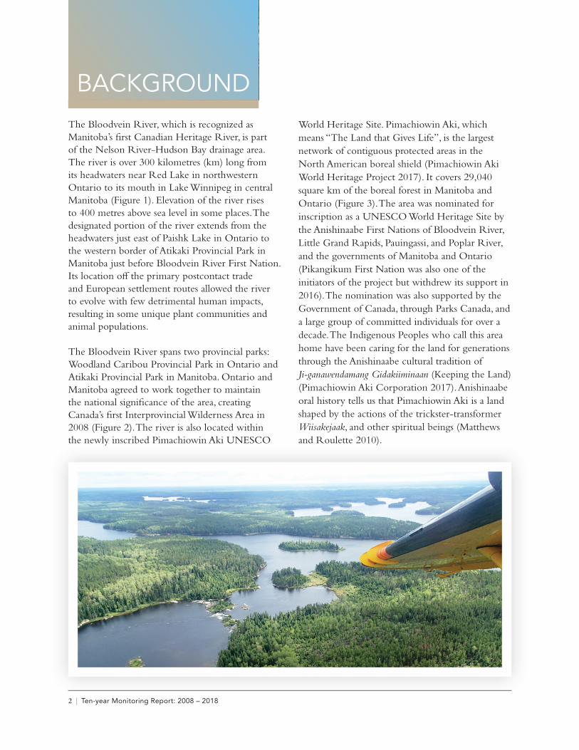
BACKGROUNDThe Bloodvein River, which is recognized as Manitoba’s first Canadian Heritage River, is part of the Nelson River-Hudson Bay drainage area. The river is over 300 kilometres (km) long from its headwaters near Red Lake in northwestern Ontario to its mouth in Lake Winnipeg in central Manitoba (Figure 1). Elevation of the river rises to 400 metres above sea level in some places. The designated portion of the river extends from the headwaters just east of Paishk Lake in Ontario to the western border of Atikaki Provincial Park in Manitoba just before Bloodvein River First Nation. Its location off the primary postcontact trade and European settlement routes allowed the river to evolve with few detrimental human impacts, resulting in some unique plant communities and animal populations.
The Bloodvein River spans two provincial parks: Woodland Caribou Provincial Park in Ontario and Atikaki Provincial Park in Manitoba. Ontario and Manitoba agreed to work together to maintain the national significance of the area, creating Canada’s first Interprovincial Wilderness Area in 2008 (Figure 2). The river is also located within the newly inscribed Pimachiowin Aki UNESCO
World Heritage Site. Pimachiowin Aki, which means “The Land that Gives Life”, is the largest network of contiguous protected areas in the North American boreal shield (Pimachiowin Aki World Heritage Project 2017). It covers 29,040 square km of the boreal forest in Manitoba and Ontario (Figure 3). The area was nominated for inscription as a UNESCO World Heritage Site by the Anishinaabe First Nations of Bloodvein River, Little Grand Rapids, Pauingassi, and Poplar River, and the governments of Manitoba and Ontario (Pikangikum First Nation was also one of the initiators of the project but withdrew its support in 2016). The nomination was also supported by the Government of Canada, through Parks Canada, and a large group of committed individuals for over a decade. The Indigenous Peoples who call this area home have been caring for the land for generations through the Anishinaabe cultural tradition of Ji-ganawendamang Gidakiiminaan (Keeping the Land) (Pimachiowin Aki Corporation 2017). Anishinaabe oral history tells us that Pimachiowin Aki is a land shaped by the actions of the trickster-transformer Wiisakejaak, and other spiritual beings (Matthews and Roulette 2010).
Bloodvein River : A Canadian Heritage River | 3
FIGURE 1: Bloodvein River corridor and surrounding area.
The Bloodvein River is located within the vast wilderness of the Canadian Shield and forms part of a network of rivers and lakes created over 11,000 years ago as the glaciers receded north across Manitoba and Ontario. The river flows through an area encompassing the most complete and diverse representation of landforms, as well as plant and animal boreal forest communities, of any area in
Manitoba or Canada (Bird and Hale Ltd. 1982). Vegetation along the Bloodvein River represents a variety of successional stages from recently burned forest stands to black spruce climax forests strewn with lichen. A large diversity of wildlife such as moose, black bear, woodland caribou, wolverine, lake sturgeon and a variety of bird species are found along the river corridor.
Limited archaeological research has taken place along the Bloodvein River in either province, and early on the research that did occur was focused on pictographs (e.g., Dewdney and Kidd, 1967; Steinbring 1987). The Bloodvein River corridor and adjacent streams contain one of the most numerous and varied array of pictographs in Canada (Dewdney and Kidd 1967; Petch 2010; Steinbring 1987); these were created by Indigenous Peoples and may date from thousands of years old to fairly recent times. Several complex groupings are of international significance in terms of scale, variety of symbols, and ties with local Ojibwe community members (Pimachiowin Aki 2017; Taylor-Hollings 2017).
Brief surveys of some parts of the river have taken place in Manitoba, completed by several different archaeologists over several decades (Petch 1991; Taylor-Hollings 2017); however, a systematic survey
has not been completed for the Manitoba side. Wall (1980) reported on the only other general archaeological survey of the Bloodvein River in Ontario before Taylor-Hollings (2017) and colleagues worked on brief reconnaissance trips along the length of the river there. Taylor-Hollings conducted reconnaissance trips from 2004 to 2017 along the length of the river, and these were the basis of her PhD thesis, “People Lived There a Long Time Ago”: Archaeology, Ethnohistory, and Traditional Use of the Miskewyaabiziibee (Bloodvein River) in Northwestern Ontario. A variety of other archaeological sites such as campsites, seasonal gathering locations, and middens had been found by earlier surveys and dated back as early as the Middle/Shield period (ca. 7,000-2,200 BP). Artifacts such as pottery (ca. 2,200-200 years BP), chipped and ground stone, cold hammered native copper, and animal bones have been discovered that provide evidence indicative of a great variety
Bloodvein River : A Canadian Heritage River | 5
of everyday activities. The oldest artifacts along the Bloodvein River have been dated back to the Paleo Period (ca. 9,000-7,000 years BP).
More recently, European independent traders, the Hudson’s Bay Company and Northwest Company used the Bloodvein River, along with resident Indigenous Peoples. It was one of the many secondary trapping areas and route ways that connected people from Hudson Bay and Lake Superior with Lake Winnipeg (Lytwyn 1986a, 1986b). Hudson’s Bay Company records indicate that several trading posts were located along the river, beginning in 1794 but only lasting for a very brief time (Lytwyn 1986a, 1986b). Fur trade artifacts have also been reported at a few sites (Taylor-Hollings 2017). As the river was off the more regular trade and settlement routes, there have likely been less negative human impacts to the
natural and cultural heritage values in this area.The Bloodvein River offers opportunities for a variety of recreational experiences including high quality wilderness canoeing, camping, fishing, nature observation and wildlife photography. A nationally significant canoeing destination, the river offers a wilderness atmosphere, challenging rapids, scenic portages, numerous viewscapes and varied landscape features. The changing character of the river from east to west provides a variety of paddling experiences ranging from flat-water sections through quiet lakes and wild rice marshes, to opportunities for white-water paddling through rapids and falls. Walleye and northern pike angling is exceptional in this area, and wildlife viewing opportunities are also abundant, with woodland caribou and moose being among the many iconic Canadian species visitors may encounter.
FIGURE 3: Pimachiowin Aki UNESCO World Heritage Site.
6 | Ten-year Monitoring Report: 2008 – 2018
METHODOLOGYSeveral methods were used to gather information for this report. These included:
• review of the Bloodvein River annual monitoring reports prepared between 2008-2017;
• review of the Bloodvein River nomination documents, decadal monitoring reports and management plans;
• a literature review of relevant research, articles and reports; and
• discussions by phone and email with individuals and agencies knowledgeable about activities on the river, including staff of Manitoba Conservation and Climate and other Manitoba government departments, Ontario Parks, Environment and Climate Change Canada, members of Bloodvein River First Nation and others.
Based on the information gathered, a table was prepared summarizing activities, events and research on the Bloodvein River between 2008-2018 (Table 1). Changes and threats to the river’s natural, cultural and recreational values, as well as the CHRS integrity values, were assessed. The actions recommended in the Atikaki Provincial Park & Bloodvein Canadian Heritage River Management Plan and the Woodland Caribou Provincial Park Management Plan were reviewed for an assessment of their degree of implementation. A table was also prepared identifying the benefits of the Bloodvein River’s CHRS designation.
Bloodvein River : A Canadian Heritage River | 7
CHRONOLOGY OF EVENTSSeveral significant events and actions have taken place along the Bloodvein River since 2008. There have also been a number of studies and research projects that have enhanced knowledge of the significant features of the river. Bloodvein River-related events, actions, research or studies that occurred between 2008-2018 are summarized in Table 1. Some of the lakes referred to in Table 1 and elsewhere throughout this report are illustrated in Figure 4.
Notably, collaboration between Manitoba and Ontario resulted in the designation of Canada’s first Interprovincial Wilderness Area in 2008. The Manitoba-Ontario Interprovincial Wilderness Area
includes Woodland Caribou Provincial Park and the Eagle-Snowshoe Conservation Reserve in Ontario, and Atikaki Provincial Park and parts of Nopiming Provincial Park in Manitoba. This designation signified a commitment by both provinces to work together to conserve the ecological integrity of this area and coordinate management activities. A few years after that designation took place an even more significant event occurred, which was the July 1, 2018 inscription of Pimachiowin Aki, which includes the Bloodvein River and its watershed, on the UNESCO World Heritage List. This site represents one of the few UNESCO World Heritage Sites recognized for both cultural and natural values.
TABLE 1: Chronology of events 2008-2018Year Significant Events, Actions, Research or Studies since 2008
2008 Removal of one commercial outcamp along the Bloodvein River in Manitoba.
Completion of Manitoba’s Atikaki Provincial Park & Bloodvein Canadian Heritage River Management plan.
Special Management Zone identified in Manitoba’s Atikaki Provincial Park & Bloodvein Canadian Heritage River Management plan. This area is intended to provide particularly high quality, wilderness canoeing experiences.
Adjustment made to river corridor boundaries in Manitoba to match Atikaki Provincial Park boundaries for the portion of river west of its junction with the Sasaginnigak River.
Designation of Manitoba-Ontario Interprovincial Wilderness Area.
Indigenous communities in Ontario were consulted regarding their interest in collaborating on vegetation/fire management plan.
Proposed boundary change to Woodland Caribou Provincial Park, which would result in more of the headwaters of the Bloodvein River in Ontario being included in the park.
Project to complete wording for Ontario’s Canadian Heritage River Plaque, which involved Elders from Pikangikum and Lac Seul First Nations working with Ontario Parks, neared completion. It was decided that the message order would be Ojibwe syllabics, English, and then French.
Construction of an access point for the Bloodvein River near Lund Lake in Ontario completed after consultation with Lac Seul and Pikangikum First Nations and an archaeological assessment occurred. Construction of an information kiosk underway.
A designated campsite system project was underway in Woodland Caribou Provincial Park. The use of designated campsites was intended to protect significant features in the park as well as the Bloodvein River.
The number of shore lunch sites in Ontario were reduced and unused sites were rehabilitated.
Jill Taylor-Hollings, a PhD student from the University of Alberta, started archaeological surveys on Knox, Murdock, Paishk, and Thicketwood lakes in collaboration with Pikangikum and Lac Seul First Nations, and Ontario Parks; approvals had been obtained prior to that through a series of meetings.
After consulting with community members from Lac Seul and Pikangikum First Nations, the official name of the headwater lake on the Bloodvein River system was changed from Peisk Lake to Paishk Lake to correct the spelling to that of the family name of Indigenous people who have long lived there.
8 | Ten-year Monitoring Report: 2008 – 2018
Year Significant Events, Actions, Research or Studies since 2008
2009 High water levels were reported on the Bloodvein River.
Planning stages began for the construction of the East Side Road in Manitoba, an all-weather road that would eventually reach Bloodvein River First Nation.
A boundary adjustment was proposed to exclude the East Side Road and associated infrastructure (bridge) from the CHRS river corridor and Atikaki Provincial Park.
Canoe route survey distributed in Manitoba to monitor visitor experience.
Work on a series of CHRS posters began.
Completed Terms of Reference describing a collaborative vegetation/fire management plan for the Woodland Caribou Signature Site.
Completed text for the Bloodvein plaques for Ontario and two plaques were produced for 2010 dedication.
Jill Taylor-Hollings continued PhD research with Little Grand Rapids First Nation and Ontario Parks, focusing on Artery Lake, Ontario.
2010 The boundary of the CHRS river corridor and Atikaki Provincial Park in Manitoba was adjusted to exclude the area of a proposed bridge and all-weather road, slightly shortening the designated corridor.
Bloodvein River First Nation developed its community-based Land Use Plan, along with the Manitoba government, which re-affirmed the protected status of the river corridor.
High water levels were reported.
Manitoba began enforcement of a prohibition on boat caches in Atikaki Provincial Park.
Aircraft landings and takeoffs and powerboating were no longer permitted in Atikaki Provincial Park from June 1 to September 15 with a few exceptions (Kautunigan and Artery lakes), in accordance with the park management plan.
Bloodvein River Plaque dedication ceremony held July 20th, 2010 in Red Lake, Ontario.
Erected entry kiosk at Lund Lake access point in Ontario, the closest road entry to the Bloodvein River.
Began vegetation/fire management planning in Ontario.
Jill Taylor-Hollings continued research regarding family history and occupancy along the Bloodvein in Ontario.
2011 Little Grand Rapids First Nation and Ontario Ministry of Natural Resources developed a community based land use plan for their traditional territory in Ontario.
Conducted an inventory of portage and campsite conditions on the Manitoba side of the Bloodvein River. Portages were found to be in good condition, campsites were clean and relatively free from vegetation damage, and flagging tape was used to indicate hazardous take-outs.
Travel restrictions due to high fire hazard reduced the number of groups travelling the river.
Water levels started off high but by end of season were below normal.
Completed Bloodvein poster in June and distributed to local communities.
Pimitotah Advisory Board (land use planning committee consisting of Bloodvein River First Nation and Manitoba Provincial Government representatives) was formed and a land use plan was published.
Pimitotah Advisory Board planned for a GPS inventory of culturally significant features to be conducted in 2012.
Submitted UNESCO World Heritage Site nomination to Paris, France in January for Pimachiowin Aki.
Forest fire starting south of Larus Lake in Ontario in mid-summer grew to over 24,000 ha in size, causing the evacuation of four outpost camps. No structures were lost. Fire surrounded Murdock Lake and re-surfaced just before Thanksgiving due to very dry conditions.
Investigation discovered a fraudulent Land Use Permit on Murdock Lake.
Ontario continued to work on vegetation/fire management plan. Posted background and scoping document on Environmental Bill of Rights (EBR) website.
Jill Taylor-Hollings continued her cultural landscape study with three First Nations and Ontario Parks.
Bloodvein River : A Canadian Heritage River | 9
Year Significant Events, Actions, Research or Studies since 2008
Continued campsite inventory and review in Woodland Caribou Provincial Park.
Prepared location to erect a second CHRS plaque at Knox Lake in Ontario through collaboration with Indigenous Elders, with a plan to erect it in 2012.
2012 Little Grand Rapids First Nation and Manitoba Conservation developed “Ni-Kes” Lands Management Plan document for their traditional territory in that province.
Reduced amount of time spent on river by River Stewards (staff who travelled the river corridor conducting light maintenance activities) in Manitoba due to staff shortages. River Stewards in Manitoba reported an increase in the number of large groups encountered.
Manitoba conducted caribou recruitment and moose population surveys.
Manitoba hired a consultant to collar wolves.
Water levels were lower than usual.
Fire impacted habitat on shore of Hooker Lake in Manitoba.
Installed CHRS plaque at Knox Lake in Ontario with participation by Indigenous Elders.
Pimachiowin Aki Corp. continued to move toward designation of a UNESCO World Heritage Site. In August, the Bloodvein River was included in a larger adjudication tour with UNESCO representatives, community members, politicians, academics, and government officials.
Famous Japanese photographer Hidehiro Otake worked in Woodland Caribou Provincial Park. Many of his photographs contributed to the Pimachiowin Aki nomination documents and other advertising for the park and site.
Jill Taylor-Hollings and community members excavated an archaeological test pit next to a local trapper’s cabin along the Bloodvein River in Ontario as part of the UNESCO adjudication site visit. Dig revealed artifacts showing repeated use of the site going back at least 2000 years and continuity of site choice.
Jill Taylor-Hollings continued ongoing research with interviews of Elders.
Ontario pursued court action regarding private land use permit on Murdock Lake.
Ontario continued development of a Vegetation Management Plan, working towards a fire driven approach to maintain ecological integrity.
Woodland caribou winter survey was completed and 40 caribou were collared across the Berens and Sydney range.
The number of shore lunch sites in Ontario was reduced and conditions were established for their use.
Snowmobiling was phased out of Larus Lake as per the phase out schedule outlined in the Woodland Caribou Management Plan with the aim to reduce mechanized activity in the area.
2013 Bloodvein River First Nation and Manitoba Historic Resources Branch conducted site investigations along the Manitoba side of the Bloodvein River resulting in the recovery of various sites and artifacts of interest.
Reductions to the River Steward program in Manitoba resulted in no River Stewards for the Bloodvein.
UNESCO deferred examination of the nomination of the Pimachiowin Aki World Heritage Site due to wanting more information from all parties involved; another nomination document was later developed.
A private recreation camp Land Use Permit in Woodland Caribou Provincial Park was shown to be fraudulent. Legal action was taken with the result being a fine totalling $35,000 and loss of the camp. Removal of the cabin and assets began.
Clean-up efforts in Ontario following the fall 2012 “snowdown” storm continued.
Archaeological investigations took place on Murdock Lake in Ontario as part of Jill Taylor-Hollings’ ongoing PhD work.
Lakehead University Aboriginal Partnership Award given to Lac Seul, Pikangikum, and Little Grand Rapids along with Doug Gilmore (Ontario Parks), Jill Taylor-Hollings (University of Alberta, Lakehead University) and Scott Hamilton (Lakehead University) for archaeological research along the Bloodvein River in Ontario.
Traplines in Ontario were repatriated to local Indigenous communities.
10 | Ten-year Monitoring Report: 2008 – 2018
Year Significant Events, Actions, Research or Studies since 2008
Ontario continued to work with local Indigenous communities while developing a designated campsite program in Woodland Caribou Provincial Park.
Manitoba and the Ontario Ministry of Natural Resources and Forestry Aviation Forest Fire and Emergency Services Section continued to develop cross-boundary response options that will allow fire to perform its ecological role.
Ontario completed a moose aerial inventory for Wildlife Management Unit 2P.
Caribou recruitment winter flights were conducted in Ontario.
2014 Manitoba completed construction of the all-weather road to Bloodvein River First Nation and the bridge over the Bloodvein River, making the west end of the river road-accessible year-round.
The Pimitotah Land Use Plan was revised and the new plan published.
Manitoba government staff observed a high volume of canoe traffic on the river in July.
Manitoba conducted aerial moose population and distribution surveys as well as a caribou satellite tracking collar study.
Manitoba conducted furbearer track surveys.
Manitoba monitored wildlife using infrared trail cameras.
The unauthorized cabin on Murdock Lake in Ontario was removed and the site returned to a more natural state.
Pimachiowin Aki Corp. continued to move toward designation of the UNESCO World Heritage Site.
Songmeters and wildlife cameras were placed along the Bloodvein River in different habitats as part of a Northwestern Ontario long-term monitoring project.
Caribou recruitment winter flights were conducted in Ontario.
2015 Increase in large canoe group traffic reported by Manitoba government staff, particularly in Atikaki Provincial Park. Groups were advised by the District Park Supervisor for Atikaki that they are required to obtain a Special Event Permit for groups over nine people.
The Pimachiowin Aki World Heritage Site nomination was submitted to UNESCO as Manitoba’s first World Heritage Site with a decision expected in 2016.
Manitoba completed consultation on a proposal from Bloodvein River First Nation to amend the Pimitotah Land Use Plan.
Manitoba approved a proposal to prohibit logging in all zones of the Pimitotah Traditional Use Planning Area.
Manitoba’s canoe route survey for Atikaki Provincial Park was updated.
Manitoba continued aerial surveys to identify moose populations and distribution, satellite tracking collaring for caribou, furbearer tracking surveys, and wildlife monitoring studies using infrared trail cameras.
The Bushey Lake boat cache in Manitoba was removed.
A number of petroforms were identified in Manitoba.
Bloodvein River First Nation identified a previously unknown petroglyph in Manitoba.
Pimachiowin Aki Corp. continued to move toward designation of a UNESCO World Heritage Site. The Bloodvein River was included in a larger adjudication tour with UNESCO representatives, community members, politicians, academics, and government officials.
Caribou recruitment winter flights were conducted in Ontario.
Long-term wildlife monitoring project continued in Ontario.
Snowmobiling was discontinued at Murdock Lake in Ontario as per the phase-out schedule.
2016 Sixty-five groups totalling over 650 participants contacted the regional office in Manitoba to obtain Special Event Permits for large-group canoe trips (primarily summer camp and/or outfitting groups) on the Bloodvein. Manitoba continued to inform organizations of this permit requirement.
Bloodvein River : A Canadian Heritage River | 11
Year Significant Events, Actions, Research or Studies since 2008
Pikangikum First Nation withdrew support for the Pimachiowin Aki World Heritage Site nomination. The World Heritage Committee referred the nomination back to Canada and a revised World Heritage Site nomination document (Pimachiowin Aki 2017) covering a smaller traditional Indigenous area was submitted with the expectation that it would be considered in 2018.
Construction of a boat launch and parking lot on Longbody Creek, which is off of the west end of the Bloodvein in Manitoba, was completed in late August (first official use August 23). The facility is to typically open on the May long weekend and close for the season by Thanksgiving.
Woodland Caribou Signature Site Vegetation Management Plan was published. The plan directs vegetation management activities for the area, recognizing that fire plays an important ecological role and can be used as an effective tool in vegetation management. The plan recommends working with Indigenous communities to incorporate Anishinaabe Eshkotay, an Indigenous customary burning practice dating back to at least the mid-1800s (Lewis 1977, 1982).
Long-term wildlife monitoring project continued in Ontario.
2017 Bloodvein River First Nation held an event in Manitoba in July celebrating the Bloodvein as part of the CHRS Canada 150 project. The event involved a pancake breakfast, followed by a youth canoe trip to a set of rapids on the river and then back to the community. The celebration concluded with a barbeque for the youth and other community members. Approximately 80 people participated.
A large event was held at Centennial Park in Red Lake, Ontario to commemorate the Bloodvein River as part of the Canada 150 project hosted by Ontario Ministry of Natural Resources and the Red Lake Heritage Centre. Various politicians, Lac Seul and Pikangikum First Nations community members, and locals participated. Large displays were set up and lunch was served.
A final revised nomination document (Pimachiowin Aki 2017) was submitted to UNESCO for consideration of Pimachiowin Aki as a World Heritage Site.
Sustainable Development and Bloodvein River First Nation provided fire pits, “garden throne” pit toilets and picnic tables for six campsites between the boundary of Atikaki Provincial Park and Bloodvein River First Nation.
A forest fire occurred along the south shore of the river five kilometres west of North Eagle Lake.
Manitoba’s River Steward program was officially discontinued in the spring.
All-weather road from Bloodvein River to Berens River in Manitoba was completed.
Manitoba conducted wildlife monitoring activities including aerial surveys covering an area within 10 km of the all-weather road.
Jill Taylor-Hollings’ PhD thesis published online with the University of Alberta.
The Canadian Heritage Rivers System’s National Conservation Award of Merit given to Lac Seul, Pikangikum, and Little Grand Rapids along with Doug Gilmore (Ontario Parks), and Jill Taylor-Hollings (University of Alberta, Lakehead University) for archaeological research along the Ontario portion of the Bloodvein River.
Long-term wildlife monitoring project continued in Ontario.
In accordance with the Woodland Caribou Provincial Park Management Plan, a review of snowmobile activities took place in Red Lake with local groups of interest that resulted in a 10-year extension of snowmobile access to Knox Lake via Paishk Lake only.
2018 On July 1, Pimachiowin Aki was inscribed as Canada’s newest UNESCO World Heritage Site.
Multiple significant fires occurred along the Bloodvein corridor in both Manitoba and Ontario. The river was closed to travel for part of the season due to these fires.
Extremely low water levels were experienced throughout the open water season along the Bloodvein River corridor.
A key element of the Monitoring Program for the new World Heritage Site – the Pimachiowin Aki Guardians Program – was selected by Environment and Climate Change Canada as part of the federal Indigenous Guardians Pilot Program.
Long-term wildlife monitoring project continued in Ontario.
12 | Ten-year Monitoring Report: 2008 – 2018
Year Significant Events, Actions, Research or Studies since 2008
Manitoba collaborated with Bloodvein River First Nation to develop new text for the Bloodvein CHRS plaque.
Manitoba and Ontario, with input from Indigenous communities and others, began work to develop a Story Map for the Bloodvein, as part of a CHRS project to develop an online GIS-based website to promote and tell the stories of rivers across the system.
FIGURE 4: Bloodvein River area lakes.
Bloodvein River : A Canadian Heritage River | 13
NATURAL HERITAGE VALUES
BackgroundRivers are nominated to the CHRS based on their outstanding natural heritage, cultural heritage, and recreational values. The Canadian Heritage Rivers System Principles, Procedures and Operational Guidelines (CHRS 2017: page 50) states that:“Outstanding Canadian natural heritage value will be recognized when a river and its immediate environment:
• is an outstanding example of river environments as they are affected by the major stages and processes in the earth’s evolutionary history as represented in Canada; or
• contains outstanding representations of significant ongoing fluvial, geomorphological and biological processes; or
• contains along its course unique, rare or outstanding examples of biotic and abiotic natural phenomena, formations or features; or
• contains along its course habitats of rare or endangered species of plants and animals, including outstanding concentrations of plants and animals of Canadian interest and significance”.
In addition to these guidelines, designated rivers represent of a number of distinct cultural and/or natural heritage and recreational values. As described in the nomination documents for the Manitoba and Ontario portions of the Bloodvein River (with updates made to the terminology and language used where appropriate), the designation of the river to the CHRS was based primarily on the following outstanding natural heritage values:
• the Bloodvein River is a wild, free-flowing river through rugged Canadian Shield largely undisturbed by human-made intrusions;
• high quality, pristine water reflects the natural conditions that have remained unaltered for hundreds of years;
• the river is situated in a relatively large, almost self-contained independent drainage basin, possibly worthy of international attention;
• the river flows through an area which encompasses the widest diversity and most complete representation of landforms and plant and animal boreal forest communities of any area in Manitoba or Canada (Bird and Hale Ltd. 1982);
• the river flows through the 2-3 billion year old Canadian Shield, the largest, best exposed craton in the world, with extensive evidence in the form of significant glacial features for the alteration of these early rocks forming the river corridor;
• the watershed supports woodland caribou, which are part of the largest surviving herds south of the James Bay Lowlands;
• intact boreal forest vegetation communities exhibiting prairie influences in terms of species composition and illustrating a variety of successional stages, from recently burned stands caused by lightening storms to lichen-strewn black spruce climax forests;
• over 350 taxa including a number of rare species with prairie, arctic and southeastern affinities, which is indicative of an area of transition from south to north and east to west; and
• habitat mosaic providing support for a wide diversity of fauna including woodland caribou, moose, black bear, timber wolves, wolverine, river otter, lynx, fisher, marten, beaver, bald eagles, osprey, great grey owls, turkey vultures, loons, Canada geese, a variety of ducks, great blue heron and chestnut lamprey.
Condition of Natural Values since 2008As the Bloodvein River is located in a fairly remote area with limited access, its original wilderness character has been largely undisturbed by human development. There have been no significant changes in the condition of the natural values of the Bloodvein River since 2008.
In Canada, the conservation status of species are assessed by the Committee on the Status of Endangered Wildlife in Canada (COSEWIC) and
14 | Ten-year Monitoring Report: 2008 – 2018
classified as either extinct, extirpated, endangered, threatened, special concern or not at risk. Based on COSEWIC’s assessment, species at risk may then be added to the official list and protected by the federal Species at Risk Act (SARA) (2002). Species may also be protected by provincial legislation. Within Manitoba, species at risk are protected by the Endangered Species and Ecosystems Act (2018). In Ontario, governing legislation is called the Endangered Species Act (2007). The conservation status of some of the species identified in previous assessments of the Bloodvein River’s natural values has changed over time. Changes in conservation status over the last decade may have occurred due to changes in species population numbers, changes in the way a population is assessed, or other factors. Table 2 notes changes to these statuses that have occurred over the last decade.
The recent construction of an all-season road and bridge over the Bloodvein River in Manitoba improved access to the area, and this has the
potential to impact natural values along the river corridor. No such impacts have been observed to date, but this is something that will be monitored into the future. Prior to construction, the designated corridor for the Bloodvein River was shortened slightly to exclude the bridge and road. The designated heritage river corridor was also extended in Ontario in 2008 to include the headwaters east of Paishk Lake. Park additions to Woodland Caribou Provincial Park were proposed at the same time, which would result in the headwaters being protected within the park.
Several forest fires have burned portions of the Bloodvein River corridor in the years since 2008, but as these events are naturally occurring and have important benefits for forest renewal, the changes they create on the landscape are not considered negatively in terms of the river’s natural values. The notable forest fires that crossed or occurred near to the Bloodvein River corridor since 2008 are illustrated in Figure 5.
FIGURE 5: Forest fires near the Bloodvein River corridor since 2008.
Bloodvein River : A Canadian Heritage River | 15
CULTURAL HERITAGE VALUES
BackgroundThe Canadian Heritage Rivers System Principles, Procedures and Operational Guidelines (CHRS 2017: page 50) states that:“Outstanding Canadian cultural value will be recognized when a river and its immediate environment:
• is of outstanding importance owing to its influence, over a period of time, on the historical development of Canada through a major impact upon the region in which it is located or beyond; or
• is strongly associated with persons, events or beliefs of national significance; or
• contains historical or archaeological structures, works or sites which are unique, rare or of great antiquity; or
• contains concentrations of historical or archaeological structures, works or sites which are representative of major themes in Canadian history”.
• As described in the nomination documents for the Manitoba and Ontario portions of the Bloodvein River (with updates made to terminology and language used where appropriate), the designation of the river to the CHRS was based primarily on the following outstanding cultural heritage values:
• the Bloodvein River is a major expression of Anishinaabe cultural landscapes indicative of Indigenous habitation for thousands of years prior to European contact including undisturbed archaeological sites, and many Indigenous pictograph sites, of which at least one is of national significance due to its size, integrity, and diversity of images;
• evidence of occupation by Indigenous people following the retreat of glaciers from the Early or Palaeo period (ca. 9,000-7,000 years BP), through the Middle period (or Shield period from ca. 7,000-2,200 years BP), to Laurel, Blackduck and Selkirk archaeological cultures during the
Woodland period (ca. 2,200-200 years BP), and after European contact;
• the river was used as a transportation route and Indigenous Peoples lived along it for thousands of years;
• the remains of fur trading posts and Indigenous habitation sites provide evidence that the river was used as a fur trapping area and transportation route during a brief but highly competitive era of the fur trade in Canada;
• the river environment today is likely similar to what it was during the Woodland period (ca. 2,200-200 years BP) of pre- and post-European contact;
• the Bloodvein is an exciting representation of an important symbol of our nation’s heritage, the Canadian Shield; and
• the Bloodvein River is included within Ontario’s Woodland Caribou Provincial Park and Manitoba’s Atikaki Provincial Park, thereby assuring that heritage values are protected.
Condition of Cultural Heritage Values since 2008The cultural heritage values of the Bloodvein River have remained largely intact with few changes to the condition of these values since designation. However, erosion, human disturbances, and potentially global warming are factors that require monitoring. Notably, research carried out along the Bloodvein River over the past decade has uncovered cultural heritage values and sites on both the Ontario and Manitoba sides that were not identified for the river at the time of nomination. An archaeological research study conducted by PhD student Taylor-Hollings (2017), in collaboration with Lac Seul, Pikangikum, and Little Grand Rapids First Nations along with Ontario Parks employees, uncovered 104 newly recorded archaeological sites, including two previously undocumented pictographs, a Thunderbird nest, and a lichenoglyph. The latter is a form of rock
16 | Ten-year Monitoring Report: 2008 – 2018
art created when a person scrapes away lichen from a rock to leave an image or can also be an interpretation of the naturally occurring lichen growth. A lichenoglyph documented in this study was naturally formed and has been maintained by community members. The newly discovered sites also include 24 rarely found precontact quartz quarrying sites, where early inhabitants obtained quartz for making tools and other uses. These sites are vulnerable to erosion and lichen growth. This research comprised brief surveys of the entire Bloodvein River system on the Ontario side. Evidence of precontact occupation by Indigenous Peoples since the Early or Palaeo Period (ca. 9,000-7,000 years BP) was found on the Ontario side, through to recent times (Taylor-Hollings 2017). Petroforms, a petroglyph, and other sites were recently investigated in Manitoba by Bloodvein River First Nation and Manitoba Historic Resources Branch archaeologists.
The natural, cultural and recreational values of the Bloodvein River were promoted in 2011 through the development and distribution of a poster intended to promote the beauty and rich history of the river. The text on the poster was written in English as well as Ojibwe, the traditional language of Indigenous communities in the area. This poster was distributed to individuals and groups with an interest in the river.
The inscription of Pimachiowin Aki as a UNESCO World Heritage Site in 2018 was very significant in terms of its international recognition of the area based on the importance of both its cultural and natural values. This project may lead to more opportunities for cultural heritage appreciation in the future.
Bloodvein River : A Canadian Heritage River | 17
RECREATIONAL VALUES
BackgroundThe Canadian Heritage Rivers System Principles, Procedures and Operational Guidelines (CHRS 2017: page 50) states that:
“Outstanding Canadian recreational value will be recognized when a river and its immediate environment possess a combination of river-related recreational opportunities and related natural and/or cultural values that together provide capability for an outstanding recreational experience.
Recreational opportunities include water-based activities such as canoeing and other forms of boating, swimming and angling, and other activities such as camping, hiking, wildlife viewing, and natural and cultural appreciation that may be part of a river-touring experience. Natural values include natural visual aesthetics, and physical assets such as sufficient flow, navigability, rapids, accessibility and suitable shoreline”.
As described in the nomination documents for the Manitoba and Ontario portions of the Bloodvein River (with updates made to terminology and language used where appropriate), the designation of the river to the CHRS was based primarily on the following outstanding recreational values:
• the Bloodvein River is rated as nationally significant for canoeing due to its wilderness atmosphere, challenging rapids, scenic portages, numerous viewscapes and varied landscape features;
• the river provides excellent opportunities for continuous water travel through an aesthetically spectacular landscape offering both flat-water and white-water canoeing opportunities;
• opportunities for appreciating natural and cultural heritage values are plentiful along the river;
• a number of opportunities for quality fishing and wildlife viewing are available along the river; and
• being located within Woodland Caribou Provincial Park and Atikaki Provincial Park will ensure that recreational opportunities along the
river are provided and that the river’s carrying capacity is not exceeded.
Condition of Recreational Values since 2008There have been a number of changes to fishing regulations over the last ten years or so in an effort to conserve this important natural resource and maintain angling opportunities into the future. The Bloodvein River continues to be an internationally known canoeing destination, travelled by new visitors each year as well as those who return repeatedly to enjoy the beauty and challenge it offers. In some years, forest fires have impacted the accessibility of the route for canoeists, but this is a natural event that has happened in the past and will happen again in the future.
The completion of the all-season road and bridge over the Bloodvein River in 2014 had the potential to affect the river’s recreational values, as it made the Manitoba side of the river directly accessible by vehicle for the first time. Enabling easier access to the Bloodvein River may result in both positive and negative impacts to the river corridor. On the one hand, there is the benefit of more people now being able to travel to and access the river, including those who may have been prevented from doing so previously due to the cost involved or logistical challenges. However, more people accessing the area, particularly by motor vehicle, has the potential to increase issues related to litter, unauthorized boat caching and crowding. Thus far, no such negative impacts have been recorded, and this is something that will continue to be monitored.
Notable changes and potential threats to the Bloodvein River’s natural, cultural and recreational values that occurred between 2008-2018 are summarized in Table 2. Values that have not been subject to any change are not listed in the table. To review the full list of values for which the Bloodvein River was designated to the CHRS, see the 2007 10-Year Monitoring Report for the river.
18 | Ten-year Monitoring Report: 2008 – 2018
TABLE 2: Changes and threats to Bloodvein River natural heritage, cultural heritage and recreational values between 2008-2018Values Description of Change in Value Reason for Change Actions Taken in Response
Natural Heritage Values
Hydrology – water flow
Monthly flow during late summer and early fall has significantly increased which seems to be a major contributor to increased annual runoff volume. Annual runoff volume reached the highest level recorded since 1976 in 2010, with the second highest record found in 2009. Decadal average runoff volumes show a significant increasing trend.
Undetermined No action required.
Biotic Environments – Aquatic Ecosystems
The designated heritage river corridor was extended in Ontario in 2008 to include the headwaters just east of Paishk Lake.
This change was made along with a proposal to expand the boundaries of Woodland Caribou Provincial Park. When the North Paishk Park Addition becomes regulated, this boundary expansion will provide greater protection to the headwaters.
None required; park expansion pending.
Fauna – Rare Species: Mammals
Little brown myotis and northern myotis, both species of bat, were first assessed as endangered by COSEWIC in 2012 and added to SARA in 2014. They are also listed as endangered under The Endangered Species and Ecosystems Act in Manitoba and the Species at Risk in Ontario list. White-nose syndrome was detected in the Red Lake area in 2017; this poses a threat to little brown myotis and northern myotis populations.
White-nose syndrome has been spreading across North America since 2006. Sub-populations elsewhere on the continent have been devastated by the disease.
Ontario published a response plan for white-nose syndrome in 2015. Manitoba continues to work with co-operating agencies to monitor the extent and impact of white-nose syndrome.
Bloodvein River : A Canadian Heritage River | 19
Values Description of Change in Value Reason for Change Actions Taken in Response
Fauna – Rare Species: Birds
Various changes have been made to the status of different bird species listed under COSEWIC and/or SARA:• Eastern whip-poor-will – designated
as threatened in 2009;• Canada warbler – designated as
threatened in 2008;• barn swallow – designated as
threatened in 2011;• bank swallow – designated as
threatened in 2013;• olive-sided flycatcher – changed from
threatened to special concern in 2018;• Eastern wood-pewee – designated as
special concern in 2012;• evening grosbeak - designated as
special concern in 2016;• rusty blackbird – designated as special
concern in 2009; and• short-eared owl - designated as special
concern in 2012.
American white pelican was listed on the Species at Risk in Ontario List as threatened in 2009 (had previously been listed as endangered).
The great blue heron was listed in the 2007 10-year report as being of special concern since 1997, however, only the fannini subspecies, found in British Columbia, was actually designated by COSEWIC as being of special concern. There is no designated conservation status for the herodias subspecies, which is the species found along the Bloodvein. The peregrine falcon is also listed in the 2007 report as being of special concern; however, the peregrine falcon is not known to be present in the area along the Bloodvein River.
Changes in conservation status have occurred due to changes in species population numbers, changes in the way a population is assessed, or other factors. Populations have declined for varying reasons, including loss of habitat in many cases. Some causes may be unknown.
No new actions identified at this time.
Fauna – Rare Species: Fish
Lake sturgeon (Saskatchewan – Nelson River populations) status as endangered re-examined and confirmed by COSEWIC in 2017.
Under COSEWIC, the chestnut lamprey was split into two populations in 2010 and its designation as a species of special concern was de-activated. The species remains designated as being of special concern under SARA.
Undetermined No new actions identified at this time.
20 | Ten-year Monitoring Report: 2008 – 2018
Values Description of Change in Value Reason for Change Actions Taken in Response
Fauna – Rare Species: Other
Snapping turtle was assessed as special concern by COSEWIC in 2008 and listed under SARA in 2011.
According to the SARA public registry, the snapping turtle’s “life history… and its dependence on long, warm summers to complete incubation successfully make it unusually susceptible to anthropogenic threats”.
No new actions identified at this time.
The mapleleaf mussel, assessed as endangered under SARA and threatened under COSEWIC, was found in the Bloodvein River in 2005. Although this observation occurred prior to 2008, it is being listed here as this species has not previously been included in the inventory of natural values for the Bloodvein.
Enriched understanding of precontact through postcontact use of the Ontario river corridor as a whole due to Indigenous knowledge holders, archaeologists, and Ontario Parks employees working together. Improved understanding of precontact use of river corridor: a probable fish trap was recorded near Knox Lake on the Bloodvein River. Indigenous knowledge holders shared information and archaeological evidence found for commercial fishing in the mid 20th century along the river (Taylor-Hollings 2017).
Research and dialogue with communities
None required
Shoreline Resource Harvesting – Trapping, Mines and Quarries
Better understanding of precontact use of the river corridor: 24 quartz quarries found in Ontario by recent archaeological studies (Taylor-Hollings 2017).
Research None required
In Woodland Caribou Provincial Park in Ontario, commercial trapping by non-Indigenous trappers has been phased out. Indigenous trapping continues.
Improved understanding of Fur Trade period and traditional use of the river corridor in Ontario: A fragment of a fur trade bead was uncovered near Knox Lake along the Bloodvein River (Taylor-Hollings 2017). Several late 19th century cans found at one location are indicative of a later fur trade site.
Research None required
Bloodvein River : A Canadian Heritage River | 21
Values Description of Change in Value Reason for Change Actions Taken in Response
Siting of Dwellings and River-based Communities
Additional postcontact sites have been identified by Indigenous community members and archaeologists including clearings, seasonal campsites, and economic activity areas.
Research and dialogue with communities
None required
Spiritual Associations – Sacred or Spiritual Sites
Improved understanding of precontact and postcontact use of the river corridor in Ontario due to Indigenous knowledge holders sharing information. Two undocumented pictograph sites and a lichenoglyph were reported; other spiritual sites, burial sites and a Thunderbird nest were identified (Taylor-Hollings 2017).
Bloodvein River First Nation and Manitoba Historic Resources Branch recently conducted site investigations along the Manitoba side of the Bloodvein River; they discovered several unrecorded sites and artifacts.
Research and dialogue with communities
None required
Recreational Values
Boating & Extended Canoe/Kayak Tripping
Construction of the all-weather road and bridge over the Bloodvein River in Manitoba increased access to the river corridor for recreational activities.
To facilitate year-round access to Indigenous communities on the East side of Lake Winnipeg.
Changes in patterns of use and potential issues such as accumulation of litter either near the river or at the Longbody Creek boat launch area will be periodically monitored.
Angling Angling opportunities continue to exist on the Bloodvein but some specific changes to angling regulations, as well as policies that affect associated activities, have been implemented:• beginning in 2018, the Bloodvein
River from the mouth at Lake Winnipeg upstream to Meekisiwi Rapids is closed to all fishing from April 2 to and including May 11;
• live bait restrictions have been implemented for the Bloodvein River in Manitoba;
• snowmobile use in Woodland Caribou Provincial Park is being gradually phased out, potentially leading to a reduction in ice fishing activity; and
• phase-out of boat caches and/or enforcement of a prohibition on boat caches is being implemented/enforced in both jurisdictions.
Management actions intended in part to reduce angling pressure on certain fish species.
No new actions are required. The baitfish policy in Ontario, including for the province’s protected areas, is being reviewed.
Camping Ontario is developing a designated campsite program to reduce disturbance footprints.
Management action None required
22 | Ten-year Monitoring Report: 2008 – 2018
Values Description of Change in Value Reason for Change Actions Taken in Response
Snowmobiling/ dog sledding
Snowmobile use in Woodland Caribou Provincial Park is being gradually phased out.
Management action None required
Natural Heritage Appreciation – Vegetation
Fires along the Bloodvein have provided the opportunity to observe post-fire regeneration and succession processes, including potential observations of rare plants that require fire activity.
Natural process None required
Human Heritage Appreciation
Inscription of Pimachiowin Aki UNESCO World Heritage Site provides greater recognition of the significance and uniqueness of the area, and suggests that opportunities for human heritage appreciation will continue to increase.
The internationally recognized nomination and designation process that took place over the course of 10+ years prior to the designation.
None required at this time; additional opportunities may arise in the future.
Bloodvein River : A Canadian Heritage River | 23
INTEGRITY GUIDELINESIn order to be designated a Canadian Heritage River, a river and its immediate environment must meet certain natural, cultural and recreational integrity value guidelines. A review of the CHRS integrity values has confirmed that the Bloodvein River continues to meet these guidelines and that they have been subject to no significant negative changes or threats. Examples of neutral or positive changes in the Bloodvein River corridor since 2008 in relation to the CHRS integrity values are described in Table 3. See Appendix A for a comprehensive list of CHRS integrity value guidelines.
TABLE 3: Changes to Bloodvein River integrity values between 2008-2018CHRS Integrity Values Changes to Integrity Values
The nominated section is of sufficient size to include significant representations of all of the natural processes, features or other phenomena that give the river its outstanding natural value.
Relatively minor changes have been made to the designated heritage river corridor in the years since 2008. It continues to be of sufficient size to contain all of the key elements and natural processes that give the river its outstanding natural value.
The natural aesthetic character of the nominated section is free of, or not adversely affected by, human developments.
The designated corridor was changed slightly in 2010 to exclude the area in Manitoba where the all-weather road and bridge would be constructed. This change was primarily due to the need to change the Atikaki Provincial Park boundary, as the road development was not compatible with the wilderness park classification and land use category (additional lands were added to the park elsewhere to compensate for the removal of land in the area of the road corridor).
The river’s visual appearance is capable of providing river travelers with a continuous natural experience, or a combined natural and cultural experience, without significant interruption by modern human intrusions.
This value may have been improved by the removal of several outcamps and boat caches from the river corridor in both provinces.
24 | Ten-year Monitoring Report: 2008 – 2018
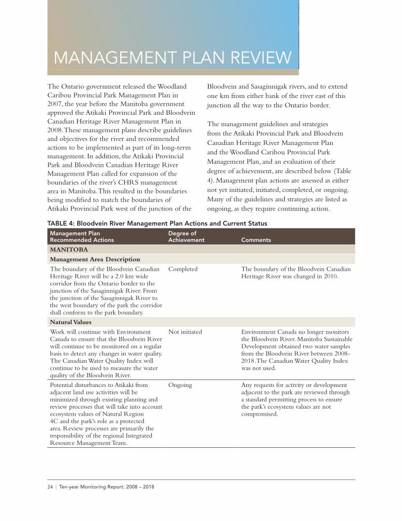
MANAGEMENT PLAN REVIEWThe Ontario government released the Woodland Caribou Provincial Park Management Plan in 2007, the year before the Manitoba government approved the Atikaki Provincial Park and Bloodvein Canadian Heritage River Management Plan in 2008. These management plans describe guidelines and objectives for the river and recommended actions to be implemented as part of its long-term management. In addition, the Atikaki Provincial Park and Bloodvein Canadian Heritage River Management Plan called for expansion of the boundaries of the river’s CHRS management area in Manitoba. This resulted in the boundaries being modified to match the boundaries of Atikaki Provincial Park west of the junction of the
Bloodvein and Sasaginnigak rivers, and to extend one km from either bank of the river east of this junction all the way to the Ontario border.
The management guidelines and strategies from the Atikaki Provincial Park and Bloodvein Canadian Heritage River Management Plan and the Woodland Caribou Provincial Park Management Plan, and an evaluation of their degree of achievement, are described below (Table 4). Management plan actions are assessed as either not yet initiated, initiated, completed, or ongoing. Many of the guidelines and strategies are listed as ongoing, as they require continuing action.
TABLE 4: Bloodvein River Management Plan Actions and Current StatusManagement Plan Recommended Actions
Degree of Achievement Comments
MANITOBA
Management Area Description
The boundary of the Bloodvein Canadian Heritage River will be a 2.0 km wide corridor from the Ontario border to the junction of the Sasaginnigak River. From the junction of the Sasaginnigak River to the west boundary of the park the corridor shall conform to the park boundary.
Completed The boundary of the Bloodvein Canadian Heritage River was changed in 2010.
Natural Values
Work will continue with Environment Canada to ensure that the Bloodvein River will continue to be monitored on a regular basis to detect any changes in water quality. The Canadian Water Quality Index will continue to be used to measure the water quality of the Bloodvein River.
Not initiated Environment Canada no longer monitors the Bloodvein River. Manitoba Sustainable Development obtained two water samples from the Bloodvein River between 2008-2018. The Canadian Water Quality Index was not used.
Potential disturbances to Atikaki from adjacent land use activities will be minimized through existing planning and review processes that will take into account ecosystem values of Natural Region 4C and the park's role as a protected area. Review processes are primarily the responsibility of the regional Integrated Resource Management Team.
Ongoing Any requests for activity or development adjacent to the park are reviewed through a standard permitting process to ensure the park’s ecosystem values are not compromised.
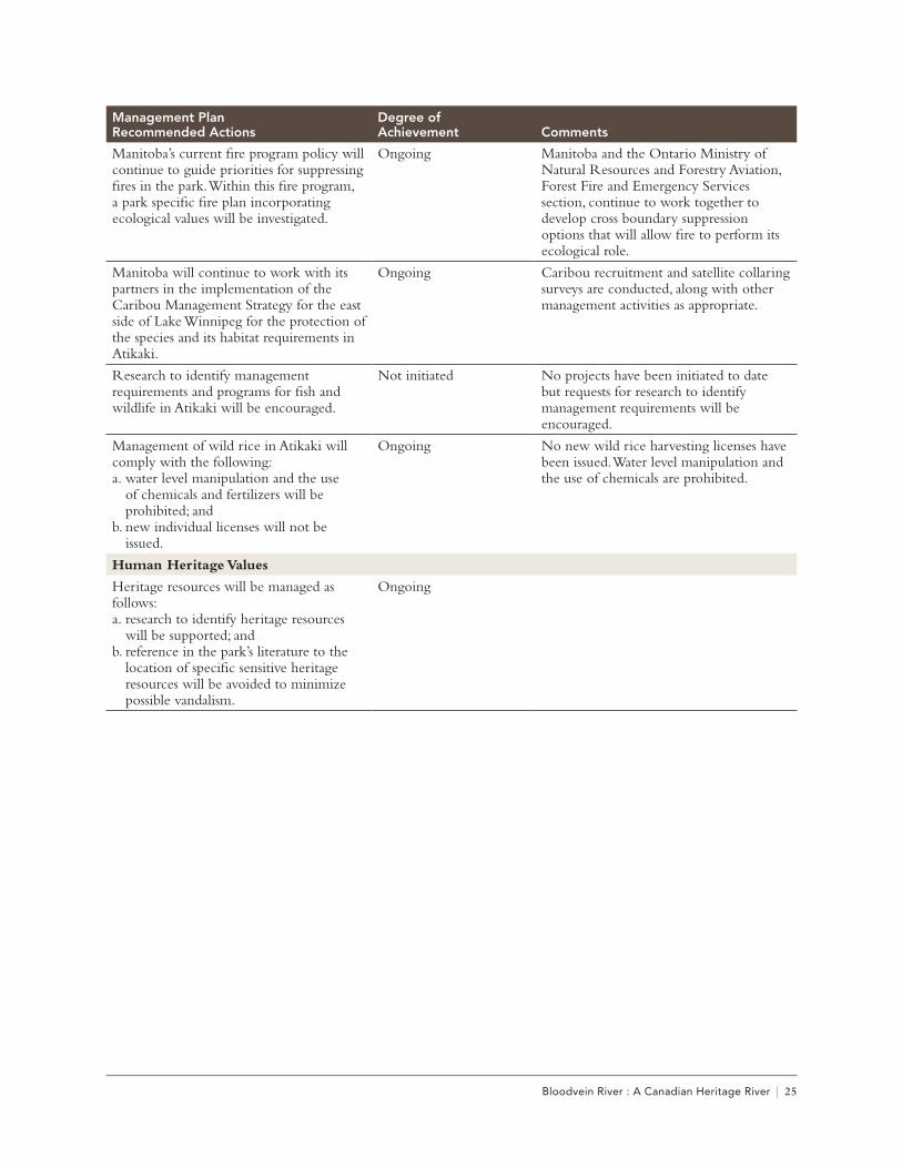
Bloodvein River : A Canadian Heritage River | 25
Management Plan Recommended Actions
Degree of Achievement Comments
Manitoba’s current fire program policy will continue to guide priorities for suppressing fires in the park. Within this fire program, a park specific fire plan incorporating ecological values will be investigated.
Ongoing Manitoba and the Ontario Ministry of Natural Resources and Forestry Aviation, Forest Fire and Emergency Services section, continue to work together to develop cross boundary suppression options that will allow fire to perform its ecological role.
Manitoba will continue to work with its partners in the implementation of the Caribou Management Strategy for the east side of Lake Winnipeg for the protection of the species and its habitat requirements in Atikaki.
Ongoing Caribou recruitment and satellite collaring surveys are conducted, along with other management activities as appropriate.
Research to identify management requirements and programs for fish and wildlife in Atikaki will be encouraged.
Not initiated No projects have been initiated to date but requests for research to identify management requirements will be encouraged.
Management of wild rice in Atikaki will comply with the following:a. water level manipulation and the use
of chemicals and fertilizers will be prohibited; and
b. new individual licenses will not be issued.
Ongoing No new wild rice harvesting licenses have been issued. Water level manipulation and the use of chemicals are prohibited.
Human Heritage Values
Heritage resources will be managed as follows:a. research to identify heritage resources
will be supported; andb. reference in the park’s literature to the
location of specific sensitive heritage resources will be avoided to minimize possible vandalism.
Ongoing
26 | Ten-year Monitoring Report: 2008 – 2018
Management Plan Recommended Actions
Degree of Achievement Comments
Recreational Values
A Special Management Zone will be identified along the major river corridors to provide high quality, wilderness canoeing experiences.
Within this zone:a. aircraft landings and take-offs will not
be permitted from June 1 to September 15, except for emergencies, park management, uses associated with wild rice operations and access to Kautunigan Lake, which is designated as a pick-up and drop-off point;
b. powerboating will not be permitted from June 1 to September 15 except for emergencies, park management and uses associated with wild rice operations;
c. aircraft and powerboat use will be permitted for activities associated with the private cabin and commercial boat cache within this zone. Negotiations for the removal/relocation of these developments will be pursued; and
d. powered white-water rafts may be permitted on the Pigeon River component of the zone.
Initiated Aircraft landings and takeoffs and powerboating are restricted as described here. Implementation of this management action was initiated in 2010.The commercial boat cache referred to in (c) was removed in 2015.
Manitoba will develop and employ a wilderness recreation management system to enable rapid and consistent assessments of the quality of visitor experiences and extent of physical impacts on portages, campsites, etc., so that appropriate management actions can be undertaken. Management actions could include:a. increasing public education on low-
impact/no trace camping;b. site management including designating
campsites and temporarily closing heavily used ones; and
c. managing use levels by implementing registration or reservation systems, as well as placing limitations on group size and length of stay.
Ongoing Canoe route surveys for Atikaki were updated in 2015.Summer camps and outfitters are required to obtain a Special Event Permit for groups of nine or more participants. Manitoba continues to communicate this requirement to user groups.
Bloodvein River : A Canadian Heritage River | 27
Management Plan Recommended Actions
Degree of Achievement Comments
Auxiliary Facilities (Boat, Motor and Fuel Caches):a. existing auxiliary facilities [will] be
permitted. New auxiliary facilities will be considered outside the Special Management Zones if an operator is willing to relinquish an existing auxiliary facility;
b. negotiations will be undertaken for the removal of the boat cache on the Bloodvein River at Bushey Lake; and
c. caching of private boats or equipment will not be permitted and such will be removed when found.
Ongoing The Bushey Lake boat cache was removed (traded for another location outside of the Bloodvein corridor) in 2015.
Private cabins:Existing private cabins and clubhouses will be permitted outside Special Management Zones. New private cabins or clubhouses will not be permitted. Negotiations will be undertaken for the removal of the existing private cabin on the Bloodvein River.
Ongoing The private cabin has not yet been removed.
Manitoba will seek a formal commitment with Ontario to establish an interprovincial wilderness area involving Atikaki and Woodland Caribou Provincial Parks.
Completed Manitoba and Ontario established Canada’s first Interprovincial Wilderness Area in 2008.
The use of snowmobiles and all-terrain vehicles (ATVs) in Atikaki will be permitted as follows:a. snowmobiles and ATVs may be used for
hunting, trapping and the maintenance of lodges, outcamps and cabins;
b. development of recreational snowmobile and ATV trails will not be permitted; and
c. permits may be issued for snowmobile access to the Manitoba portion of Obukowin Lake utilizing the access route from Siderock Lake.
Ongoing Development of recreational snowmobile and ATV trails has not been permitted. Snowmobiles and ATVs continue to be used for hunting, trapping, and maintenance purposes.
Manitoba will work with Ontario and the communities and First Nations surrounding Atikaki Provincial Park to investigate and pursue a nomination for inscription of the area as an UNESCO World Heritage Site.
Completed The Pimachiowin Aki World Heritage Site was inscribed in 2018. This project was the result of collaboration between Bloodvein, Little Grand Rapids, Pauingassi, and Poplar River First Nations along with Manitoba, Ontario, Parks Canada, and others.
28 | Ten-year Monitoring Report: 2008 – 2018
Management Plan Recommended Actions
Degree of Achievement Comments
Strategies for interpreting natural and cultural features will continue to be developed. Strategies that will be investigated include:a. orientation and interpretive displays
and materials at key entry points, tourist lodges and communities surrounding the park;
b. interpretive training and information for commercial operators in the park;
c. specific brochures and publications dealing with selected management and interpretive issues as required, i.e. the production of an educational video on the woodland caribou;
d. presentations on an Internet Website; ande. the development, in co-operation with
non-government organizations, of publications for use on the rivers, such as waterproof maps.
Ongoing The Manitoba Parks website was updated to include more information on backcountry and wilderness camping, as well as on paddling the Bloodvein. The Bloodvein River poster produced in 2011 provides information on the river’s natural and cultural features.
Manitoba has offered interpretive training and information to commercial operators but to date there has been no interest.The Bloodvein River Story Map will be a new tool for interpretation once available online. Additional strategies and products will be investigated as opportunities arise and resources permit.
ONTARIO
Boundary
Regulate Ontario’s Living Legacy planning area (OLL) and Whitefeather Forest and Adjacent Area recommended park additions as part of Woodland Caribou Provincial Park.
Initiated The Sydney/Rowdy and Douglas/Foley park additions became regulated as part of Woodland Caribou Provincial Park in 2014. The two park additions associated with the Bloodvein River headwaters, Paishk Lake North and Paishk/Lund, are still pending regulation.
Resource Management
Prepare a vegetation management plan which will consider Woodland Caribou Provincial Park’s unique prairie-boreal habitat mosaic, critical habitat for forest-dwelling woodland caribou, Indigenous habitat manipulation and fire’s role in the ecosystem.
Completed The Woodland Caribou Signature Site Vegetation Management Plan was published in 2016.
In association with the vegetation management plan, fire management planning will be undertaken in cooperation with the Ministry of Natural Resources and Forestry’s fire program. This plan will further develop objectives and protection priorities, and guide implementation through fire response and fire use.
Completed The Woodland Caribou Signature Site Vegetation Management Plan includes a fire response plan that guides fire objectives in the Woodland Caribou Signature Site.
In order to protect and maintain the resident forest dwelling woodland caribou population, periodic monitoring of the population and the protection of critical habitat (e.g. winter habitat and calving/nursing areas) will be implemented.
Ongoing Conducted formal and informal winter aerial surveys, recruitment surveys, calving surveys, GPS collar tracking and collected genetic material from caribou. Protection of critical habitat incorporated into adjacent forest management plans and fire response plans.
Bloodvein River : A Canadian Heritage River | 29
Management Plan Recommended Actions
Degree of Achievement Comments
Implement an education program on the effects of introducing non-native fish species into a natural system.
Ongoing Ontario Invasive Species Strategic Plan released in 2012. Several education programs offered by Ontario’s Invading Species Awareness Program.
Pursue conservation limits only for sport fishing in Woodland Caribou Provincial Park.
Not initiated There is no interest in pursuing this recommendation at this time.
Continue consultation with First Nations and the Ministry of Culture, Sports, and Tourism to determine the most effective way of protecting significant cultural areas as they are identified.
Ongoing Indigenous Elders and community members have identified culturally significant areas that should or should not be identified or disturbed.
Operations
Prepare a park operating plan to provide park staff with the necessary information required to operate the park on a day-to-day basis. The park operating plan will include administration, staffing, occupational health and safety, maintenance schedules, enforcement and emergency services. The operating plan will be reviewed annually and revised as required.
Completed A Park Specific Plan that guides standards and management of the park was developed in 2016.
Ongoing evaluation of the recreational resources of the park in order to establish use targets and recreation management prescriptions consistent with the long-term protection of the park.
Ongoing Portage trails and campsites are evaluated and maintained regularly in Ontario.
The introduction of a visitor management program based as determined through an ongoing assessment of recreational impacts on park resources and implemented through a quota-based entry system.
Not initiated It was determined that a visitor management program is not required at this time.
A campsite system will be developed which will restrict use to authorized campsites designated on a park campsite map. Campsites will be periodically monitored for site deterioration including unauthorized structures, tree damage, litter, root exposure, loss of vegetative ground cover and human waste.
Ongoing A designated campsite system project is currently underway in Woodland Caribou Provincial Park.
Seasonally manage camping on islands and peninsulas in areas of importance to woodland caribou. These campsites will be identified on the park campsite map and will be closed from May 1 to June 30 of each year.
Not initiated It was decided not to pursue this objective at this time.
Activities in seasonal access zones will be monitored and should sustainability of the resource be at risk, quota-based entry regulations may be applied. The timing restrictions for seasonal access will also be monitored and re-evaluated on an ongoing basis.
Ongoing
30 | Ten-year Monitoring Report: 2008 – 2018
Management Plan Recommended Actions
Degree of Achievement Comments
The development of an Ontario Parks Boat Cache Agreement.
Ongoing Currently part of the MNRF boat cache program.
Develop and implement a strategy to remove remote fly-in boat caches.
Ongoing All remote fly-in boat caches have been removed from the Bloodvein.
A natural heritage education plan will be prepared as part of the park operating plan. Specific program direction may include education initiatives designed to enhance awareness of, and involvement in, the park by area schools and other interest groups such as naturalist clubs or youth groups. Other initiatives could include structured and unstructured recreation opportunities for exploration and appreciation of Indigenous culture, the fur trade, earth and life science features, and the Bloodvein Canadian Heritage River as well as interpretive opportunities with partners of the park.
Not initiated Education initiatives in the community occur but are not part of a formal plan.
Ontario Parks will work with local groups, school boards, the Red Lake Publicity Board, First Nations and the tourism industry to develop and distribute information about the park, park system, local and regional attractions.
Ongoing Ontario Parks facilitates Indigenous Elders giving presentations to youth groups visiting the park, gives annual school presentations and participates in local events to promote the park. A park exhibit took place at the local Red Lake Heritage Centre in the summer of 2017. Park information is posted online, including through social media.
Woodland Caribou Provincial Park will work with Pikangikum and other First Nation partners in the research and interpretation of Indigenous culture.
Ongoing Jill Taylor-Hollings has completed multiple reports, academic posters, presentations and her archaeology PhD thesis, which was published online in 2017. The park continues to work with Pikangikum, Lac Seul, Little Grand Rapids and other First Nations, along with academics.
Implement the creation of an Interprovincial Wilderness Area in cooperation with the province of Manitoba.
Completed Manitoba and Ontario established Canada’s first Interprovincial Wilderness Area in 2008.
Development
Expand the present canoe route system where better distribution of users is required and/or where new experiences may be created.
Ongoing Some route scouting has taken place.
Relocate portages due to environmental damage.
Ongoing Portage into Knox Lake re-routed and developed in 2016 to reduce damage.
Inventory and evaluate existing and potential campsites to obtain the appropriate campsite potential of Woodland Caribou Provincial Park. As a result of this inventory some existing campsites may have to be relocated or closed.
Ongoing Initial inventory and screening complete. Some campsites have been closed due to sensitivities or logistical reasons. Campsite appropriateness may change with new information or forest fire disturbances.
Bloodvein River : A Canadian Heritage River | 31
Management Plan Recommended Actions
Degree of Achievement Comments
Develop and improve parking areas at Lund Lake and Leano Lake access zones respectively. Improve parking areas in the Johnson Lake and Onnie Lake areas which provide initial access to the Douglas Creek (A11) and Hjalmar Lake (A12) access zones.
Completed Construction of an access point, including a parking lot, information kiosk and portage trail for the Bloodvein River at Lund Lake was completed. Parking areas at Leano Lake, Johnson Lake and Onnie Lake were improved and kiosks with park information constructed.
Develop or identify safe loading and unloading areas within air access zones.
Completed Docks were constructed on Artery Lake and Sabourin Lake to help facilitate air access.
Construct information kiosks at major entry points to relay important park messages for people entering the park.
Completed Erected entry kiosk at Lund Lake access point, the closest road entry to the Bloodvein River.
32 | Ten-year Monitoring Report: 2008 – 2018
BENEFITS OF DESIGNATIONA recently added requirement of CHRS 10-year monitoring reports is to describe any benefits resulting from the designation. The most obvious and important benefit of the designation of the Bloodvein River is that it supports conservation of the river and preservation of its values. This
designation continues to play a key role in the celebration of the river’s natural, cultural and recreational values. The various benefits of CHRS designation that have been identified for the Bloodvein River are listed in Table 5.
TABLE 5: Benefits of the Bloodvein River CHRS designationType of Benefit Description
Environmental and Cultural Benefits
• The designation contributed to the decision to re-align a segment of the new, all-season road constructed at the west end of the river corridor to avoid impacting sensitive cultural sites.
• The designation and associated CHRS monitoring requirements were included as important considerations in the documents supporting the nomination of the Pimachiowin Aki UNESCO World Heritage Site.
• The increased profile of the river across Canada and recognition of its significance has led to greater appreciation of the river’s history and features, and prompted further research into archaeological sites and cultural heritage.
Recreational Benefits • The designation supports the rationale behind restricting motorized activities and recreational facilities within the river corridor to an even greater degree than that prescribed for the other areas within Atikaki and Woodland Caribou provincial parks. This helps to maintain the wilderness experience the river offers.
Improved Knowledge • Understanding of vegetation, landscapes, wildlife, cultural history and other values was improved through the preparation of background and nomination documents. This was also accomplished through discussions with Indigenous traditional knowledge holders for several parts of the river.
Stewardship, Community Engagement and Collaboration
• The designation provides greater support and/or opportunities for activities and events to take place in the area of the river corridor, such as the Canada 150 celebrations that occurred in 2017.
• Increased dialogue and collaborations with Anishinaabe Indigenous communities with traditional territories along the river is now occurring.
Development of Communications Products
• The Bloodvein’s status as a Canadian Heritage River has been noted in various media publications.
• The designation has encouraged the production of materials such as a promotional/educational poster and the Bloodvein River Story Map.
• The designation is promoted on the Ontario Parks and Manitoba Parks websites.• Social media including Facebook, Twitter, and Instagram are being used to
promote all Canadian Heritage Rivers, including the Bloodvein.
Bloodvein River : A Canadian Heritage River | 33
CONCLUSIONS AND RECOMMENDATIONS
Based on the findings of this report, the natural heritage, cultural heritage and recreation values of the Bloodvein River are determined to be intact and any significant changes to those values are considered to be positive. Therefore, the Bloodvein River is worthy of continued designation as a river of national significance within the CHRS.
It should be noted that on-the-ground monitoring activities specifically for the purposes of this report were not conducted, largely due to budgetary and logistical constraints. It is recommended that Manitoba and Ontario work together to develop an approach for the next Bloodvein River 10-year report that includes a fieldwork component, with this work to ideally be conducted in both provinces.
In addition, it is recommended that Manitoba and Ontario work toward updating the known inventory of cultural heritage values for the Bloodvein River, in partnership with the Indigenous communities and organizations with an interest in the river. Although several archaeologists have worked on the Manitoba side of the river in past decades (e.g., Petch 1991, 2010), sometimes along with Bloodvein River First Nation community members, a complete archaeological survey of the Manitoba side has not yet been completed. The recent work of Taylor-Hollings (2017), Lac Seul, Little Grand Rapids, and Pikangikum First Nations along with Ontario Parks referenced throughout this report made a significant contribution in terms of recording knowledge related to the archaeology, ethnohistory, and traditional knowledge of the river in Ontario, but there is more that can be done in this regard.
34 | Ten-year Monitoring Report: 2008 – 2018
OVERALL ASSESSMENTThe designation of the Bloodvein River as a Canadian Heritage River should remain in place.
Bloodvein River : A Canadian Heritage River | 35
APPENDIX A: CHRS Natural, Cultural and Recreational Integrity Values1. NATURAL INTEGRITY VALUES• The nominated section is of sufficient size to include significant representations of all of the natural
processes, features or other phenomena that give the river its outstanding natural value.
• The nominated section includes those ecosystem components which contribute significantly to the provision of habitat for species in need of protection.
• There are no human-made impoundments within the nominated section.
• All key elements and ecosystem components are unaffected by impoundments located outside the nominated section.
• The water in the nominated section is uncontaminated to the extent that its natural aquatic ecosystem is intact.
• The natural aesthetic character of the nominated section is free of, or not adversely affected by, human developments.
2. CULTURAL INTEGRITY VALUES• The nominated section is of sufficient size to include significant representations of all of the features,
activities or other phenomena that give the river its outstanding cultural value.
• The visual character of the nominated section enables uninterrupted appreciation of at least one of the periods of the river’s historical importance.
• The key artifacts and sites comprising the cultural values for which the river is nominated, are unimpaired by impoundments and human land uses.
• The water quality of the nominated section does not detract from the visual character or the cultural experience provided by its cultural values.
3. RECREATIONAL INTEGRITY VALUES• The river possesses water of a quality suitable for contact recreational activities, including those
recreational opportunities for which it is nominated.
• The river’s visual appearance is capable of providing river travelers with a continuous natural experience, or a combined natural and cultural experience, without significant interruption by modern human intrusions.
• The river is capable of supporting recreational uses without significant loss of, or impact on, its natural and cultural values or its visual character.
36 | Ten-year Monitoring Report: 2008 – 2018
ReferencesReports, Articles and Literature:Davidson-Hunt I., N. Deutsch, and A.M. Miller. 2012. Pimachiowin Aki Cultural Landscape Atlas: Land
That Gives Life. Winnipeg: Pimachiowin Aki Corporation.
Dewdney, S., and K. Kidd. 1962. Indian Rock Paintings of the Great Lakes. Toronto: University of Toronto Press.
Lewis, H.T. 1977. Muskuta: The Ecology of Indian Fires in Northern Alberta. Western Canadian Journal of Anthropology 7:15-52.
Lewis, H.T. 1982. A time for burning. Occasional Publication Number 17. Edmonton: Boreal Institute for Northern Studies, University of Alberta.
Lytwyn, V.P. 1986a. The Fur Trade History of the Bloodvein River. Woodland Caribou Technical Report #5. Red Lake: Ontario Ministry of Natural Resources, Red Lake District.
Lytwyn, V.P. 1986b. The Fur Trade of the Little North: Indians, Pedlars, and Englishmen East of Lake Winnipeg, 1760-1821. Winnipeg: Rupert’s Land Research Centre, University of Winnipeg.
Matthews, M., and R. Roulette. 2010. Mapping the Ojibwe Universe, Giishkaanadong: Ojibwe Cosmology Discussion Paper. Winnipeg: Prepared for Pimachiowin Aki World Heritage Site Corporation.
Petch, V. 1991. An Archaeological Survey of the Sasaginnigak River System Including the Kautunigan Lake Area. Manitoba Archaeological Journal 1(2):23-44.
Petch, V. 2010. Pimachiowin Aki Cultural Landscape – Macro Scale Document. A report prepared for the Pimachiowin Aki Corporation, Winnipeg, MB. Pimachiowin Aki World Heritage Project: The Land that Gives Life. Nomination for Inscription on the World Heritage List.
Taylor-Hollings, J. 2017. “People Lived There a Long Time Ago”: Archaeology, Ethnohistory, and Traditional Use of the Miskweyaabiziibee (Bloodvein River) in Northwestern Ontario. Unpublished PhD dissertation, Department of Anthropology, University of Alberta, Edmonton.
Steinbring, J. 1987. The Sasaginnigak Lake Rock Painting Site, EjKv-P3. Manitoba Archaeological Quarterly 11(1):3-47.
Wall, R.D. 1980. Archaeological Survey of the Bloodvein River System. In Studies in West Patricia Archaeology No. 1 1978-1979, pp. 71-81, edited by C.S. “Paddy” Reid. West Patricia Heritage Resource Report 1, Archaeological Research Report 15. Toronto: Historical Planning and Research Branch, Ministry of Culture and Recreation.
Water Quality Management Section. Manitoba Sustainable Development. 2008. Winnipeg: Bloodvein Water Quality Data.
Water Survey Canada (WSC). Environment Canada. 1976-2016. Bloodvein River Hydrometric Station.
Bloodvein River : A Canadian Heritage River | 37
Websites:
https://pimaki.ca Pimachiowin Aki Corporation. 2018.
Background Studies and Planning Documents:Bird and Hale Ltd. 1982. Regional Analysis Study of Natural Region 1: The Central Boreal Uplands.
Ottawa: Parks Canada.
Bloodvein First Nation and Manitoba Planning Team. 2011. Pimitotah: To Care for Our Land. Bloodvein First Nation Land Use Plan.
Canadian Heritage Rivers System – various annual reports from 2008-2017.
Canadian Heritage Rivers System. 2001. A Cultural Framework for Canadian Heritage Rivers. Ottawa: Minister of Public Works and Government Services Canada.
Canadian Heritage Rivers System. 2001. A Framework for the Natural Values of Canadian Heritage Rivers. Ottawa: Minister of Public Words and Government Services Canada.
Canadian Heritage Rivers System. 2017. Principles, Procedures and Operational Guidelines.
Hilderman Thomas Frank Cram. 1997. Canadian Heritage Rivers System: Systems Study of Rivers in Manitoba. Winnipeg, Manitoba: Report Prepared for Parks Canada, Department of Canadian Heritage.
Hilderman Thomas Frank Cram. 2000. Canadian Heritage Rivers System: Bloodvein River Monitoring Report (1987-2000). Winnipeg, Manitoba: Report Prepared for Manitoba Conservation, Parks and Natural Areas Branch and Canadian Heritage Rivers Board.
Hilderman Witty Crosby Hanna and Associations. 1986. Bloodvein Heritage River Management Plan.Winnipeg, Manitoba: Report Prepared for Manitoba Parks Branch.
Jackson, J.E. 1998. Managing the Bloodvein River as a Canadian Heritage River: Bloodvein River (Ontario Portion) Resource Management Strategy. Prepared for Ontario Parks/Parks Canada. Thunder Bay: Government of Ontario.
Little Grand Rapids First Nation and Manitoba. 2012. Little Grand Rapids First Nation “Ni-Kes” Lands Management Plan Manitoba Planning Area. Winnipeg, Manitoba.
Little Grand Rapids First Nation and Ontario Ministry of Natural Resources. 2011. Little Grand Rapids Community Based Land Use Plan. Red Lake, Ontario.
Manitoba Parks Branch. 1984. Canadian Heritage Rivers System: Bloodvein River Nomination Document (unpublished newsletter). Winnipeg, Manitoba.
38 | Ten-year Monitoring Report: 2008 – 2018
Manitoba Conservation. 2001. Atikaki Interpretive Park Map. Winnipeg, Manitoba.
Manitoba Conservation. 2005. Manitoba’s Conservation and Recovery Strategy for Boreal Woodland Caribou. Winnipeg, Manitoba.
Manitoba Conservation. 2008. Atikaki Provincial Park and Bloodvein Canadian Heritage River Management Plan. Winnipeg, Manitoba.
Newman, C., and D. Gilmore. 2007. Canadian Heritage Rivers Systems: Bloodvein River Monitoring Report 07. Report prepared for Manitoba Conservation, Woodland Caribou Provincial Park, and Canadian Heritage Rivers Board.
Ontario Ministry of Natural Resources. 2007. Woodland Caribou Provincial Park Management Plan. Red Lake, Ontario.
Ontario Ministry of Natural Resources and Forestry. 2016. Woodland Caribou Signature Site Vegetation Management Plan. Red Lake, Ontario.
Pikangikum First Nation and Ontario Ministry of Natural Resources. 2006. Cheekahnahwaydahmungk Keetahkeemeenaan (Keeping the Land): A Land Use Strategy for the Whitefeather Forest and Adjacent Areas. Planning document produced by Pikangikum First Nation and the OMNR. Queen’s Printer for Ontario and Pikangikum First Nation.
Pimachiowin Aki World Heritage Project. 2016. Pimachiowin Aki World Heritage Project - The Land that Gives Life: Nomination for Inscription on the World Heritage List. Document submitted to UNESCO in January 2016.
Pimachiowin Aki World Heritage Project. 2016. Management Plan Appendix I.