44
INFORMATION & INFORMATION & TRAINING GUIDE TRAINING GUIDE 2021 2021 MASTER MASTER NATIONAL NATIONAL

INFORMATION &INFORMATION &TRAINING GUIDETRAINING GUIDE
2021
2021
MA
STER
MA
STER
NA
TIO
NA
LN
ATI
ON
AL

2

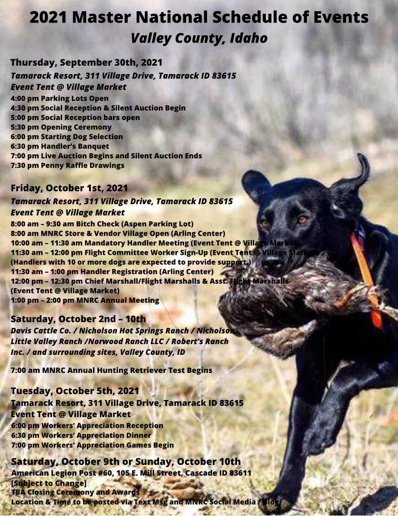
2021 Master National Schedule of EventsValley County, Idaho
Thursday, September 30th, 2021
4:00 pm Parking Lots Open4:30 pm Social Reception & Silent Auction Begin5:00 pm Social Reception bars open5:30 pm Opening Ceremony6:00 pm Starting Dog Selection6:30 pm Handler’s Banquet7:00 pm Live Auction Begins and Silent Auction Ends7:30 pm Penny Raffle Drawings
Tamarack Resort, 311 Village Drive, Tamarack ID 83615Event Tent @ Village Market
8:00 am – 9:30 am Bitch Check (Aspen Parking Lot)8:00 am MNRC Store & Vendor Village Open (Arling Center)10:00 am – 11:30 am Mandatory Handler Meeting (Event Tent @ Village Market)11:30 am – 12:00 pm Flight Committee Worker Sign-Up (Event Tent @ Village Market)(Handlers with 10 or more dogs are expected to provide support.)11:30 am – 1:00 pm Handler Registration (Arling Center)12:00 pm – 12:30 pm Chief Marshall/Flight Marshalls & Asst. Flight Marshalls(Event Tent @ Village Market)1:00 pm – 2:00 pm MNRC Annual Meeting
Friday, October 1st, 2021Tamarack Resort, 311 Village Drive, Tamarack ID 83615Event Tent @ Village Market
Saturday, October 2nd – 10thDavis Cattle Co. / Nicholson Hot Springs Ranch / NicholsonLittle Valley Ranch /Norwood Ranch LLC / Robert’s RanchInc. / and surrounding sites, Valley County, ID
7:00 am MNRC Annual Hunting Retriever Test Begins
Tuesday, October 5th, 2021Tamarack Resort, 311 Village Drive, Tamarack ID 83615Event Tent @ Village Market6:00 pm Workers’ Appreciation Reception6:30 pm Workers’ Appreciation Dinner7:00 pm Workers’ Appreciation Games Begin
Saturday, October 9th or Sunday, October 10thAmerican Legion Post #60, 105 E. Mill Street, Cascade ID 83611[Subject to Change]TBA Closing Ceremony and AwardsLocation & Time to be posted via Text Msg and MNRC Social Media / Blog

Welcome to Valley County, IdahoValley County is a rural county located in west-central Idaho. Established in 1917, it was named after the North Fork of thePayette River, which extends over 30 miles from Payette Lake at McCall south to Cascade and on to Round Valley. Thevalley was formerly a summer pasture for livestock from the Boise area. Since completion of Cascade Dam in 1948, muchof the northern valley has been covered by the Cascade Reservoir. From the 1910s, logging, farming and ranching werethe economic mainstays of the county, however changes in federal policy have virtually eliminated timber harvest onNational Forest System lands. This has resulted in a shift to a recreation based economy.
Although the valley portion of the county contains ranches and farms, many visitors are surprised to learn that 91% ofthe county is public land. 88% of Valley County is contained in portions of the Payette, Boise, and Salmon-Challis NationalForests, while 3% is state land. The county, with the exception of some flat land along the rivers, is a high and rugged arearanging from rolling wooded plateaus to 10,000 foot peaks along the Middle Fork of the Salmon River.
This expanse of public land makes Valley County a recreation paradise, suited for nearly every form of outdoor activity.Hiking, backpacking, mountain biking, Alpine and Nordic skiing, whitewater rafting/kayaking, snowmobiling, camping,hunting and fishing combine to make the area a year round playground which has resulted in the small communities ofMcCall and Cascade becoming popular recreation destinations. Three Alpine ski areas, as well as several excellent golfcourses, serve the area. A network of roads and trails on public land offers use by off-road vehicles, motorcycles, horsesand hiking, while over 500 miles of trails are groomed for snowmobile use in winter.
Located in the geographical center of the state, the county is still very rural. There are only two traffic lights in the county(both in McCall), and the permanent county-wide population is only about 10,400. As visitors come to the area onsummer holidays and during the McCall winter Carnival, the population of McCall can grow to over 60,000. Luckily, the2021 Master National occurs after the summer peak of visitors and before deer and elk seasons. You should enjoy ourbeautiful fall weather , with seasonable day and cool night temperatures. We hope you enjoy our county!
5

6

ContentsMaster National Schedule of Events . . . . . . . . . . . . . . . . . . . . . . 4Welcome to Valley County . . . . . . . . . . . . . . . . . . . . . . . . . . . . . . . 5Master National Map . . . . . . . . . . . . . . . . . . . . . . . . . . . . . . . . . . . 6About Our Pin . . . . . . . . . . . . . . . . . . . . . . . . . . . . . . . . . . . . . . . . . . 8Sporting Dog Permit . . . . . . . . . . . . . . . . . . . . . . . . . . . . . . . . . . . . 9Training/Testing Site Rules/Regulations . . . . . . . . . . . . . . . . . . 10Sheep in McCall . . . . . . . . . . . . . . . . . . . . . . . . . . . . . . . . . . . . . . . .11Property #1 . . . . . . . . . . . . . . . . . . . . . . . . . . . . . . . . . . . . . . . . . . . 12Property #2 . . . . . . . . . . . . . . . . . . . . . . . . . . . . . . . . . . . . . . . . . . . 13Property #3 . . . . . . . . . . . . . . . . . . . . . . . . . . . . . . . . . . . . . . . . . . . 15Property #4 . . . . . . . . . . . . . . . . . . . . . . . . . . . . . . . . . . . . . . . . . . . 18Property #5 . . . . . . . . . . . . . . . . . . . . . . . . . . . . . . . . . . . . . . . . . . . 20Property #6 & #7 . . . . . . . . . . . . . . . . . . . . . . . . . . . . . . . . . . . . . . .22Property #8 . . . . . . . . . . . . . . . . . . . . . . . . . . . . . . . . . . . . . . . . . . . 26Property #9 . . . . . . . . . . . . . . . . . . . . . . . . . . . . . . . . . . . . . . . . . . . 27Property #10  . . . . . . . . . . . . . . . . . . . . . . . . . . . . . . . . . . . . . 28Property #12 . . . . . . . . . . . . . . . . . . . . . . . . . . . . . . . . . . . . . . . . . . 29Property #13 . . . . . . . . . . . . . . . . . . . . . . . . . . . . . . . . . . . . . . . . . . 31Property #14 . . . . . . . . . . . . . . . . . . . . . . . . . . . . . . . . . . . . . . . . . . 34Property #15 . . . . . . . . . . . . . . . . . . . . . . . . . . . . . . . . . . . . . . . . . . 36Property #16 & #17 . . . . . . . . . . . . . . . . . . . . . . . . . . . . . . . . . . . . 37 Public Training "Bear Basin" . . . . . . . . . . . . . . . . . . . . . . . . . . . . 38Public Training "Squaw Basin" . . . . . . . . . . . . . . . . . . . . . . . . . . 39 Public Training "Sugarloaf" . . . . . . . . . . . . . . . . . . . . . . . . . . . . . 40 Public Training "Upper Payette" . . . . . . . . . . . . . . . . . . . . . . . . . 42
7ON THE COVER:CWR's She's So Fly "Lacey" Photo/Owned By Dave Alexander

-About Our Pin-
Many folks have described the location of the 2021 Master Nationalas being in McCall, Idaho, which is the location of one of the largestand most popular AKC hunt tests in the west. Every July, theTreasure Valley Hunting Retriever Club hosts an event that offersdouble header tests in junior, Senior and Master stakes. In planning the 2021 Master National event, however, werecognized the need for a much larger venue, and expanded toinclude all of Valley County, Idaho. Only by using land throughoutthe county have we been able to put the event together.Landowners from Cascade, Donnelly and McCall graciously haveallowed the use of their lands for both training and testing. Eventhough there are training sites located in nearby Adams and Idahocounties, the focus of this event is clearly Valley County. The citiesof Cascade (the county seat), and the largest city in the county,McCall, have been important parts of providing logistic support.Tamarack Resort, a popular destination resort near Donnelly, willhost several gatherings, and the host hotel, the Holiday Inn, is inMcCall.In designing the pin for this year’s event, we started with the stateof Idaho and the location of Valley County central within it. Thered, white and blue background colors copy the generic Idaholicense plate, and the logos of both the Master National RetrieverClub and the host Treasure Valley Hunting Retriever Club areprominently displayed. With this pin, we recognize the effortsthroughout Valley County, the State of Idaho, and both clubs.
8
9
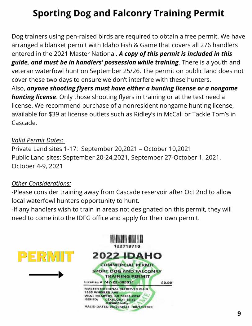
Sporting Dog and Falconry Training Permit
Dog trainers using pen-raised birds are required to obtain a free permit. We havearranged a blanket permit with Idaho Fish & Game that covers all 276 handlersentered in the 2021 Master National. A copy of this permit is included in thisguide, and must be in handlers’ possession while training. There is a youth andveteran waterfowl hunt on September 25/26. The permit on public land does notcover these two days to ensure we don’t interfere with these hunters.Also, anyone shooting flyers must have either a hunting license or a nongamehunting license. Only those shooting flyers in training or at the test need alicense. We recommend purchase of a nonresident nongame hunting license,available for $39 at license outlets such as Ridley’s in McCall or Tackle Tom’s inCascade.
Valid Permit Dates: Private Land sites 1-17: September 20,2021 – October 10,2021Public Land sites: September 20-24,2021, September 27-October 1, 2021,October 4-9, 2021
Other Considerations:-Please consider training away from Cascade reservoir after Oct 2nd to allowlocal waterfowl hunters opportunity to hunt.-If any handlers wish to train in areas not designated on this permit, they willneed to come into the IDFG office and apply for their own permit.
PERMITPERMITPERMIT

Training/Test Site General Rules Regulations-A Guide to the Use of Training Properties-
The following “Guidelines” list important considerations for the use of the pre-Master National TrainingGrounds and the Master National Hunt Test Grounds. All of these grounds were made available for theevent by their property owners for the betterment of the community and their love of dogs. These rulesand regulations are certainly not all inclusive of every possible situation that may arise. Please use commonsense, and above all, professional courtesy while on the properties and when coming in contact withothers on the properties. We are guests and we must utilize the properties with the least amount ofintrusiveness possible. The Training Property sites are open from 8 AM – 5pm, September 24 untilSeptember 30
1. SMOKING OUTSIDE OF YOUR VEHICLE IS STRICTLY PROHIBITED on the Test Grounds and ALLTraining Property Grounds. NO EXCEPTIONS.2. SEE “SHEEP IN IDAHO” AS WELL AS INSTRUCTIONS ON INDIVIDUAL PROPERTIES.3. The Use of these grounds shall be coordinated through the random draws for property use.4. No one may contact the owners for individual or group use or access these properties except throughthe Hunt Test Committee.5. The regulations listed for each property in the training catalog are in addition to thesegeneral guidelines.6. Unless instructed otherwise, please close and secure all gates at all times.7. Keep vehicles to the edges of fields and away from pond banks. Access fields only with UTV’s or 4-wheelers if available.8. Be wary of livestock and neighbors.9. Never shoot in the direction of any visible residence.10. Remove all of your trash, including spent shells, dead birds and any other trash you find. Do not leavefood scraps or spilled dog food on the grounds. Some properties specifically prohibit feeding on thegrounds due to moving wildlife. WE DO HAVE MOUNTAIN LIONS AND WOLVES IN THE AREA!!11. Stay well-away from kennels and residences unless otherwise directed by property owners.12. By entering any of these properties you acknowledge the risks inherent in outdoor sports whethersuch risks are apparent or hidden. All participants accept those risks and agree that they alone areresponsible for the health and safety for themselves and others in their group. Participants, by their use ofthe properties, acknowledge that they hold the property owners, MNRC, TVHRC, its officers and membersharmless and free of any liability for accidents, injuries or damage to their persons or vehicles. Entering anyof the properties is further subject to the participants’ agreement to be held fully responsible for anydamage, accidental or otherwise, to the property and any animals, facilities, buildings or equipment locatedon the property.13. Enjoy these wonderful properties but PLEASE, be courteous to the landowners and their neighbors.14. MOST IMPORTANT, if grounds and grasses are still very dry, then NO USE OF 209/22 BLANKS in anywinger. Fire moves very quickly and we don’t want anyone to get hurt or lose their life.15. PLEASE PICK UP AFTER YOUR DOGS!! Especially on groomed grounds! Use Porta Potty on property ifavailable for yourself!!
10
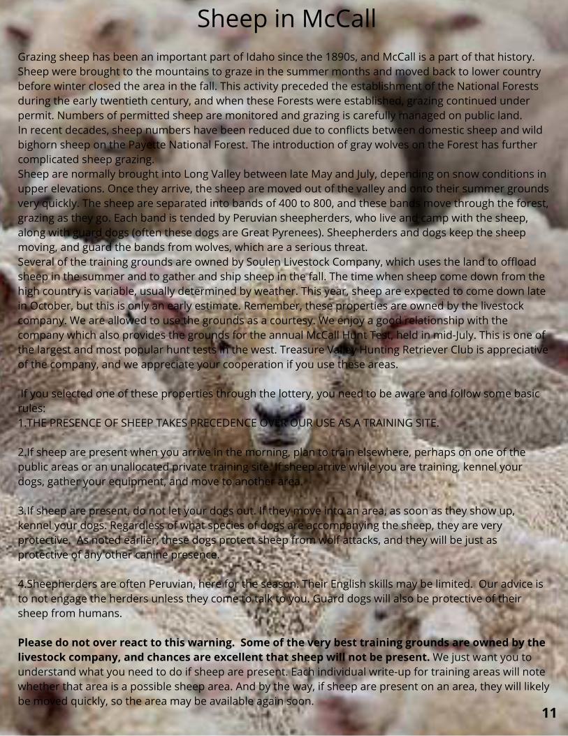
Sheep in McCallGrazing sheep has been an important part of Idaho since the 1890s, and McCall is a part of that history.Sheep were brought to the mountains to graze in the summer months and moved back to lower countrybefore winter closed the area in the fall. This activity preceded the establishment of the National Forestsduring the early twentieth century, and when these Forests were established, grazing continued underpermit. Numbers of permitted sheep are monitored and grazing is carefully managed on public land.In recent decades, sheep numbers have been reduced due to conflicts between domestic sheep and wildbighorn sheep on the Payette National Forest. The introduction of gray wolves on the Forest has furthercomplicated sheep grazing.Sheep are normally brought into Long Valley between late May and July, depending on snow conditions inupper elevations. Once they arrive, the sheep are moved out of the valley and onto their summer groundsvery quickly. The sheep are separated into bands of 400 to 800, and these bands move through the forest,grazing as they go. Each band is tended by Peruvian sheepherders, who live and camp with the sheep,along with guard dogs (often these dogs are Great Pyrenees). Sheepherders and dogs keep the sheepmoving, and guard the bands from wolves, which are a serious threat.Several of the training grounds are owned by Soulen Livestock Company, which uses the land to offloadsheep in the summer and to gather and ship sheep in the fall. The time when sheep come down from thehigh country is variable, usually determined by weather. This year, sheep are expected to come down latein October, but this is only an early estimate. Remember, these properties are owned by the livestockcompany. We are allowed to use the grounds as a courtesy. We enjoy a good relationship with thecompany which also provides the grounds for the annual McCall Hunt Test, held in mid-July. This is one ofthe largest and most popular hunt tests in the west. Treasure Valley Hunting Retriever Club is appreciativeof the company, and we appreciate your cooperation if you use these areas.
If you selected one of these properties through the lottery, you need to be aware and follow some basicrules:1.THE PRESENCE OF SHEEP TAKES PRECEDENCE OVER OUR USE AS A TRAINING SITE.
2.If sheep are present when you arrive in the morning, plan to train elsewhere, perhaps on one of thepublic areas or an unallocated private training site. If sheep arrive while you are training, kennel yourdogs, gather your equipment, and move to another area.
3.If sheep are present, do not let your dogs out. If they move into an area, as soon as they show up,kennel your dogs. Regardless of what species of dogs are accompanying the sheep, they are veryprotective. As noted earlier, these dogs protect sheep from wolf attacks, and they will be just asprotective of any other canine presence.
4.Sheepherders are often Peruvian, here for the season. Their English skills may be limited. Our advice isto not engage the herders unless they come to talk to you. Guard dogs will also be protective of theirsheep from humans.
Please do not over react to this warning. Some of the very best training grounds are owned by thelivestock company, and chances are excellent that sheep will not be present. We just want you tounderstand what you need to do if sheep are present. Each individual write-up for training areas will notewhether that area is a possible sheep area. And by the way, if sheep are present on an area, they will likelybe moved quickly, so the area may be available again soon.
11

Flyers: Yes
Water: Yes (limited). Inspectthe creek for steep banksbefore setting up.
Land: Yes
Address: Off of WestMountain RoadGPS: 44.89043, -116.14982
Property #1 Directions: From the traffic light on the south side of McCall,turn west on Deinhard Lane. Travel 1.7 miles to aleft turn on West Valley Road.After 0.2 miles, thisroad will turn left 90 degrees and becomeWisdom Road. Proceed approximately 0.2 milesto a “T” intersection. Turn right onto WestMountain Road. Proceed 0.9 miles to the entry tothis property on the left. The left turn is on asharp right hand curve so use caution. Theproperty will have a Master National TrainingGround sign on the gate.THIS PROPERTY MAY HAVE SHEEP PRESENT.PLEASE REVIEW GUIDELINES FORINTERACTING WITH SHEEP.
Attributes/Description: This property is named The Tenth Seriesbecause it was the site of the 10th and finalseries of both the 1999 and 2003 NationalAmateur Field Trials. This property offersthe opportunity to train in sage and utilizea variety of slopes. Williams Creek runsthrough it and may have steep banks.If thegrasses are tall, handlers should check forhidden tree stumps. The area mayaccommodate a large group.
IF SHOOTING LIVE FLYERS, DO NOTSHOOT TOWARDS ANY HOMES
ORLIVESTOCK PRESENT ONADJACENT PROPERTY
12

Flyers: Yes
Water: No
Land: Yes
Address: Off West MountainRoad
GPS: 44.88127, -116.14737
Property #2Directions: From the traffic light on the south side of McCall,turn west on Deinhard Lane. Travel 1.7 miles toa left turn on West Valley Road.After 0.2 miles,this road will turn left 90 degrees and becomeWisdom Road. Proceed approximately 0.2 milesto a “T” intersection. Turn right onto WestMountain Road. Proceed 1.8 miles to the entryto this property on the left. The property willhave a Master National Training Ground sign atthe entrance. This road serves a working graveloperation. Trucks may be using the entry roadand will have the right of way.Please allow forpassage when parking along the road.THIS PROPERTY MAY HAVE SHEEP PRESENT.PLEASE REVIEW GUIDELINES FORINTERACTING WITH SHEEP. Attributes/Description:
This property offers land seriesthrough sage and grass. Some brushpiles and scattered pines are presentto create complexity.The terrain isrolling and field trial distances areavailable. The area shouldaccommodate a large group.
13
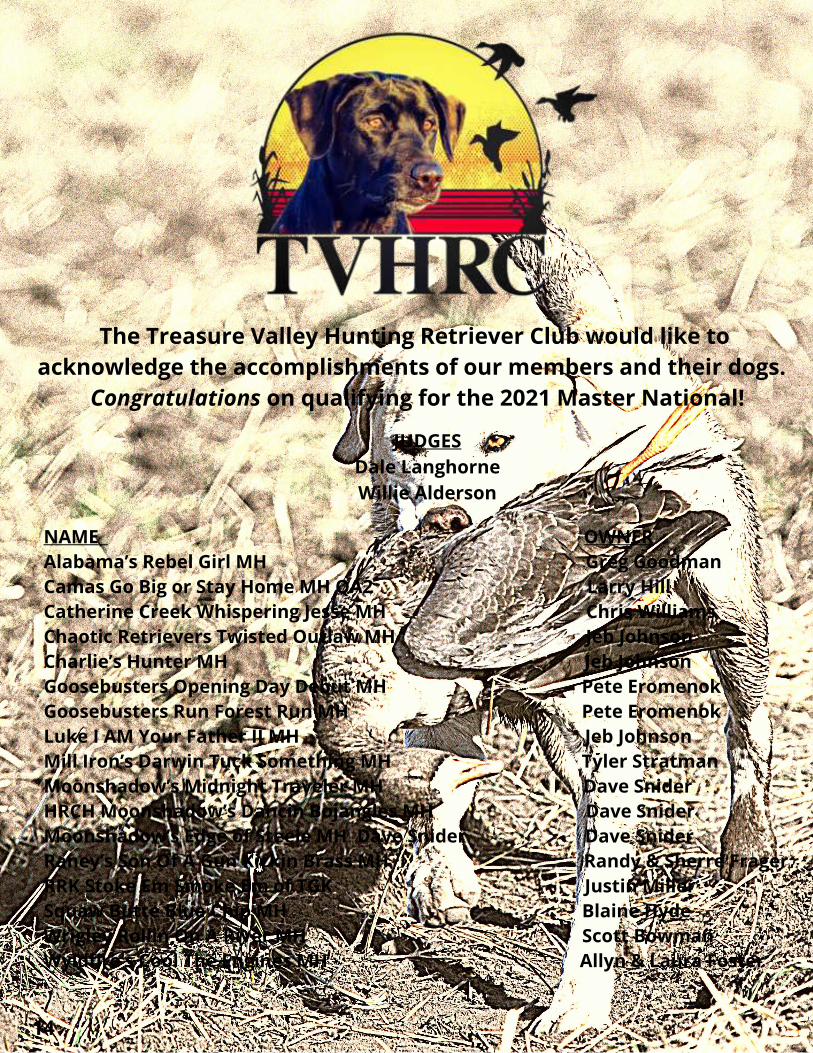
The Treasure Valley Hunting Retriever Club would like toacknowledge the accomplishments of our members and their dogs.
Congratulations on qualifying for the 2021 Master National!
JUDGESDale LanghorneWillie Alderson
NAME OWNER Alabama’s Rebel Girl MH Greg Goodman Camas Go Big or Stay Home MH QA2 Larry HillCatherine Creek Whispering Jesse MH Chris Williams Chaotic Retrievers Twisted Outlaw MH Jeb Johnson Charlie’s Hunter MH Jeb Johnson Goosebusters Opening Day Debut MH Pete Eromenok Goosebusters Run Forest Run MH Pete Eromenok Luke I AM Your Father II MH Jeb Johnson Mill Iron’s Darwin Tuck Something MH Tyler Stratman Moonshadow’s Midnight Traveler MH Dave Snider HRCH Moonshadow’s Dancin Bojangles MH Dave Snider Moonshadow’s Edge of Steele MH Dave Snider Dave SniderRaney’s Son Of A Gun Kickin Brass MH Randy & Sherre FragerRRK Stoke Em Smoke Em of TGK Justin MillerSquaw Butte Blue Chip MH Blaine Hyde Wrigley Rollin On A River MH Scott Bowman Wyldfire’s Cool The Engines MH Allyn & Laura Foster
14
Flyers: Yes
Water: Yes
Land: Yes
Address: Off West MountainRoad, Meckel Gravel Pit
GPS: 44.87740, -116.13500
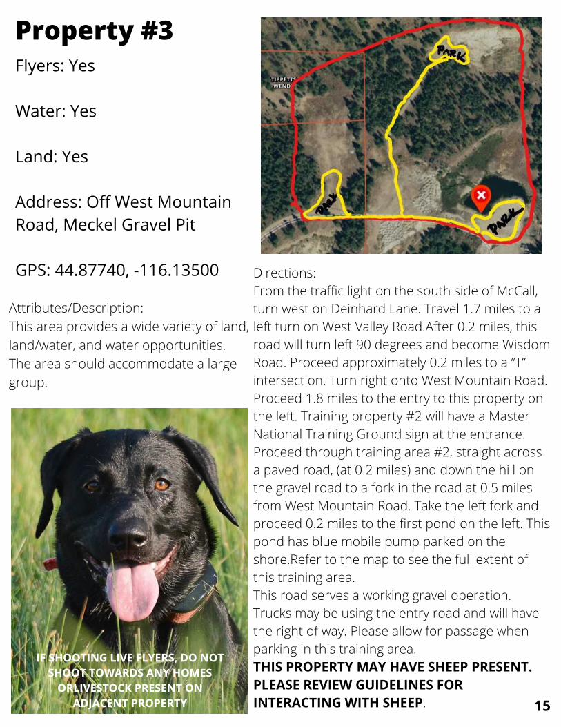
Property #3
Directions:From the traffic light on the south side of McCall,turn west on Deinhard Lane. Travel 1.7 miles to aleft turn on West Valley Road.After 0.2 miles, thisroad will turn left 90 degrees and become WisdomRoad. Proceed approximately 0.2 miles to a “T”intersection. Turn right onto West Mountain Road.Proceed 1.8 miles to the entry to this property onthe left. Training property #2 will have a MasterNational Training Ground sign at the entrance.Proceed through training area #2, straight acrossa paved road, (at 0.2 miles) and down the hill onthe gravel road to a fork in the road at 0.5 milesfrom West Mountain Road. Take the left fork andproceed 0.2 miles to the first pond on the left. Thispond has blue mobile pump parked on theshore.Refer to the map to see the full extent ofthis training area.This road serves a working gravel operation.Trucks may be using the entry road and will havethe right of way. Please allow for passage whenparking in this training area.THIS PROPERTY MAY HAVE SHEEP PRESENT.PLEASE REVIEW GUIDELINES FORINTERACTING WITH SHEEP.
Attributes/Description:This area provides a wide variety of land,land/water, and water opportunities.The area should accommodate a largegroup.
IF SHOOTING LIVE FLYERS, DO NOTIF SHOOTING LIVE FLYERS, DO NOTSHOOT TOWARDS ANY HOMESSHOOT TOWARDS ANY HOMES
ORLIVESTOCK PRESENT ONORLIVESTOCK PRESENT ONADJACENT PROPERTYADJACENT PROPERTY 15

16

17
Flyers: Yes
Water: Yes
Land: Yes
Address: Off West MountainRoad, Meckel Gravel Pit
GPS: 44.875466, -116.13384
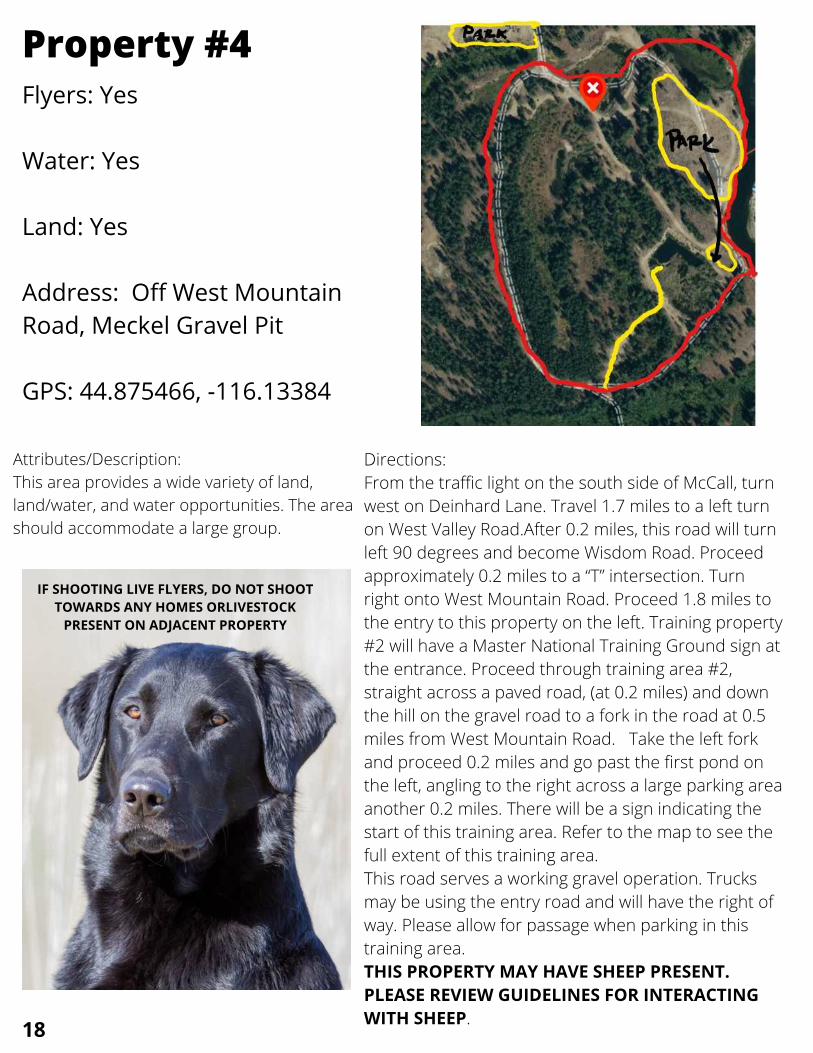
Property #4
Directions:From the traffic light on the south side of McCall, turnwest on Deinhard Lane. Travel 1.7 miles to a left turnon West Valley Road.After 0.2 miles, this road will turnleft 90 degrees and become Wisdom Road. Proceedapproximately 0.2 miles to a “T” intersection. Turnright onto West Mountain Road. Proceed 1.8 miles tothe entry to this property on the left. Training property#2 will have a Master National Training Ground sign atthe entrance. Proceed through training area #2,straight across a paved road, (at 0.2 miles) and downthe hill on the gravel road to a fork in the road at 0.5miles from West Mountain Road. Take the left forkand proceed 0.2 miles and go past the first pond onthe left, angling to the right across a large parking areaanother 0.2 miles. There will be a sign indicating thestart of this training area. Refer to the map to see thefull extent of this training area.This road serves a working gravel operation. Trucksmay be using the entry road and will have the right ofway. Please allow for passage when parking in thistraining area.THIS PROPERTY MAY HAVE SHEEP PRESENT.PLEASE REVIEW GUIDELINES FOR INTERACTINGWITH SHEEP.
Attributes/Description:This area provides a wide variety of land,land/water, and water opportunities. The areashould accommodate a large group.
IF SHOOTING LIVE FLYERS, DO NOT SHOOTIF SHOOTING LIVE FLYERS, DO NOT SHOOTTOWARDS ANY HOMES ORLIVESTOCKTOWARDS ANY HOMES ORLIVESTOCK
PRESENT ON ADJACENT PROPERTYPRESENT ON ADJACENT PROPERTY
18

Your Real Estate Guide for 208 Life!Your Master National Judge for 2021
LOOKING TO LOOKING TO LOOKING TO BUY OR SELLBUY OR SELLBUY OR SELL IN IDAHO? IN IDAHO? IN IDAHO?
YOU HANDLE YOUR DOG TO THE BLIND,YOU HANDLE YOUR DOG TO THE BLIND,YOU HANDLE YOUR DOG TO THE BLIND,
AND I'LL HANDLE THE REST!AND I'LL HANDLE THE REST!AND I'LL HANDLE THE REST!
Willie Alderson208-991-8543
Flyers: Yes
Water: Yes
Land: Yes
Address: Off West MountainRoad, Meckel Gravel Pit
GPS: 44.870054, -116.140613
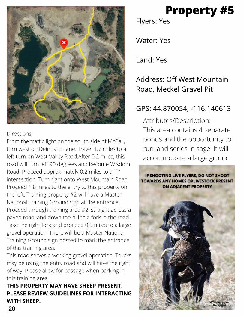
Property #5
Directions:From the traffic light on the south side of McCall,turn west on Deinhard Lane. Travel 1.7 miles to aleft turn on West Valley Road.After 0.2 miles, thisroad will turn left 90 degrees and become WisdomRoad. Proceed approximately 0.2 miles to a “T”intersection. Turn right onto West Mountain Road.Proceed 1.8 miles to the entry to this property onthe left. Training property #2 will have a MasterNational Training Ground sign at the entrance.Proceed through training area #2, straight across apaved road, and down the hill to a fork in the road.Take the right fork and proceed 0.5 miles to a largegravel operation. There will be a Master NationalTraining Ground sign posted to mark the entranceof this training area. This road serves a working gravel operation. Trucksmay be using the entry road and will have the rightof way. Please allow for passage when parking inthis training area.THIS PROPERTY MAY HAVE SHEEP PRESENT.PLEASE REVIEW GUIDELINES FOR INTERACTINGWITH SHEEP.
Attributes/Description:This area contains 4 separateponds and the opportunity torun land series in sage. It willaccommodate a large group.
20

OFF10 %A L L B E V E R A G E S ! !
The Lake Fork Merc is a small convenience store and gas stationwith an espresso bar. We sell beer, wine, hot food, soda, snacks
and more! Please stop in and visit us on scenic highway 55, inthe heart of Idaho, just 5 miles south of McCall.
13845 Hwy 55 McCall, ID 83635
(208) 634-411421
Flyers: Yes
Water: Yes (limited)
Land: Yes
Address: Off West MountainRoad
GPS: 44.809456, -116.169582
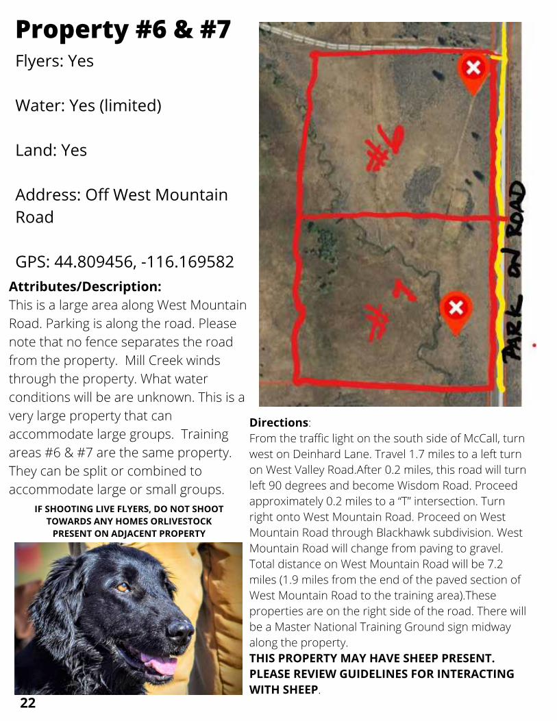
Property #6 & #7
Directions:From the traffic light on the south side of McCall, turnwest on Deinhard Lane. Travel 1.7 miles to a left turnon West Valley Road.After 0.2 miles, this road will turnleft 90 degrees and become Wisdom Road. Proceedapproximately 0.2 miles to a “T” intersection. Turnright onto West Mountain Road. Proceed on WestMountain Road through Blackhawk subdivision. WestMountain Road will change from paving to gravel.Total distance on West Mountain Road will be 7.2miles (1.9 miles from the end of the paved section ofWest Mountain Road to the training area).Theseproperties are on the right side of the road. There willbe a Master National Training Ground sign midwayalong the property. THIS PROPERTY MAY HAVE SHEEP PRESENT.PLEASE REVIEW GUIDELINES FOR INTERACTINGWITH SHEEP.
Attributes/Description:This is a large area along West MountainRoad. Parking is along the road. Pleasenote that no fence separates the roadfrom the property. Mill Creek windsthrough the property. What waterconditions will be are unknown. This is avery large property that canaccommodate large groups. Trainingareas #6 & #7 are the same property.They can be split or combined toaccommodate large or small groups. IF SHOOTING LIVE FLYERS, DO NOT SHOOTIF SHOOTING LIVE FLYERS, DO NOT SHOOT
TOWARDS ANY HOMES ORLIVESTOCKTOWARDS ANY HOMES ORLIVESTOCKPRESENT ON ADJACENT PROPERTYPRESENT ON ADJACENT PROPERTY
22

24

25

Flyers: Yes
Water: No
Land: Yes
Address: Off West MountainRoad
GPS: 44.769947, -116.155460
Property #8
Directions:From the traffic light on the south side ofMcCall, turn west on Deinhard Lane.Travel 1.7 miles to a left turn on WestValley Road.After 0.2 miles, this road willturn left 90 degrees and become WisdomRoad. Proceed approximately 0.2 miles toa “T” intersection. Turn right onto WestMountain Road. Proceed on WestMountain Road through Blackhawksubdivision. West Mountain Road willchange from paving to gravel. Totaldistance on West Mountain Road will be10.2 miles (4.9 miles from the end of thepaved section of West Mountain Road tothe training area).The property is on theleft side of the road. There will be aMaster National Training Ground sign atthe gate. Please close the gate behind youwhen you enter and leave.
Attributes/Description:There may be water present. Thisis primarily a land series at thistime of year. As you proceed intothe property take care to not driveinto a boggy section of the road.
26
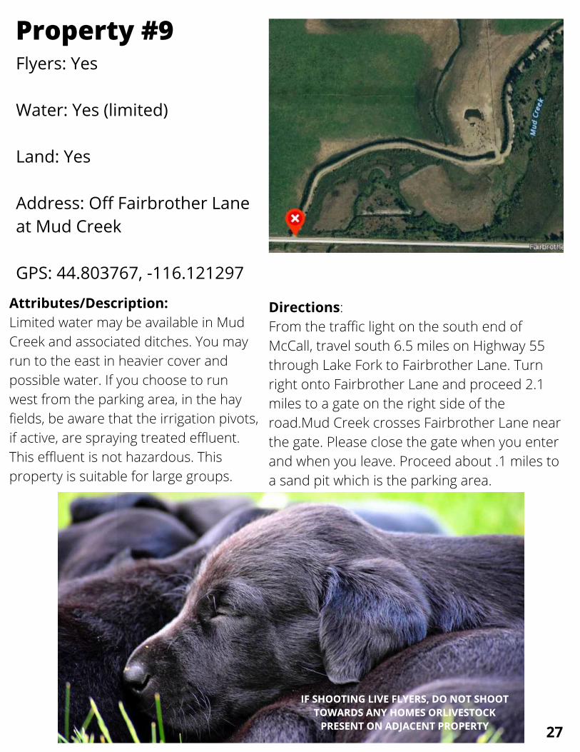
Flyers: Yes
Water: Yes (limited)
Land: Yes
Address: Off Fairbrother Laneat Mud Creek
GPS: 44.803767, -116.121297
Property #9
Directions:From the traffic light on the south end ofMcCall, travel south 6.5 miles on Highway 55through Lake Fork to Fairbrother Lane. Turnright onto Fairbrother Lane and proceed 2.1miles to a gate on the right side of theroad.Mud Creek crosses Fairbrother Lane nearthe gate. Please close the gate when you enterand when you leave. Proceed about .1 miles toa sand pit which is the parking area.
Attributes/Description:Limited water may be available in MudCreek and associated ditches. You mayrun to the east in heavier cover andpossible water. If you choose to runwest from the parking area, in the hayfields, be aware that the irrigation pivots,if active, are spraying treated effluent.This effluent is not hazardous. Thisproperty is suitable for large groups.
IF SHOOTING LIVE FLYERS, DO NOT SHOOTIF SHOOTING LIVE FLYERS, DO NOT SHOOTTOWARDS ANY HOMES ORLIVESTOCKTOWARDS ANY HOMES ORLIVESTOCK
PRESENT ON ADJACENT PROPERTYPRESENT ON ADJACENT PROPERTY 27

Flyers: Yes
Water: No
Land: Yes
Address: Junction of NorwoodRoad & Fairbrother Lane
GPS: 44.803681, -116.101465
Property #10 & #11
Directions:From the traffic light on the south end ofMcCall, travel south 6.5 miles on Highway 55through Lake Fork to Fairbrother Lane. Turnright onto Fairbrother Lane and proceed 1.1miles to a gate on the left side of the road.Please close the gate when you enter and whenyou leave. At the other end of the right of way isanother gate onto Smiley Lane, which alsoconnects back to Highway 55. This gate shouldremain closed. Both gates will be marked with aMaster National Training Property sign.
Attributes/Description:These two training sites may be combined toaccommodate large groups or usedseparately by smaller groups. The railroadright-of-way is private land and shouldaccommodate all vehicles. There may bewater present off the right-of-way.However,this depends on the rainfall in the season.
IF SHOOTING LIVE FLYERS, DO NOT SHOOTTOWARDS ANY HOMES OR LIVESTOCK
PRESENT ON ADJACENT PROPERTY
28
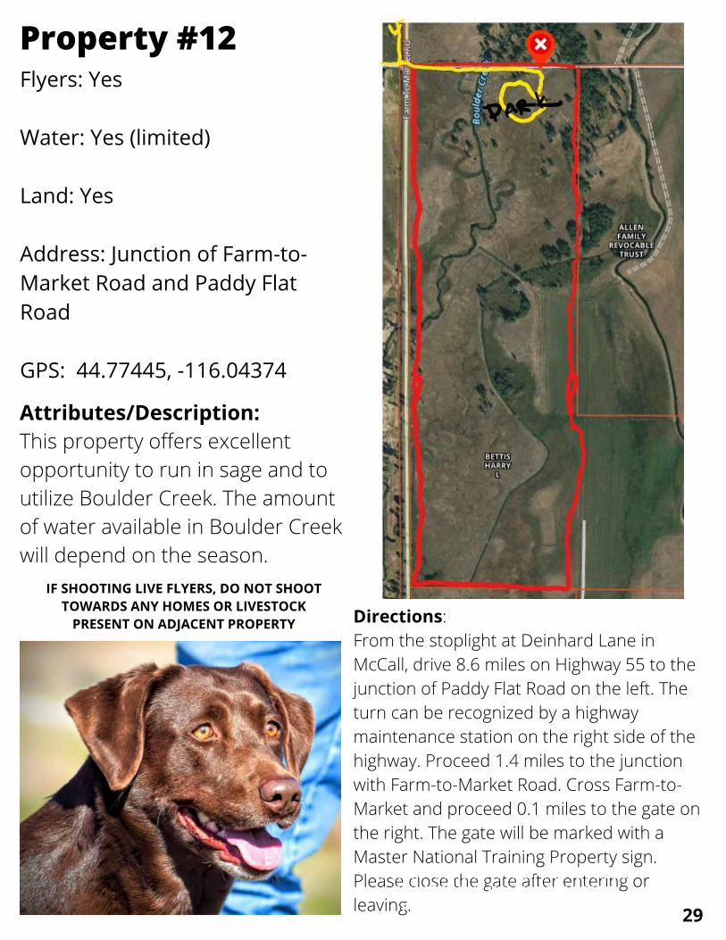
Flyers: Yes
Water: Yes (limited)
Land: Yes
Address: Junction of Farm-to-Market Road and Paddy FlatRoad
GPS: 44.77445, -116.04374
Property #12
Directions:From the stoplight at Deinhard Lane inMcCall, drive 8.6 miles on Highway 55 to thejunction of Paddy Flat Road on the left. Theturn can be recognized by a highwaymaintenance station on the right side of thehighway. Proceed 1.4 miles to the junctionwith Farm-to-Market Road. Cross Farm-to-Market and proceed 0.1 miles to the gate onthe right. The gate will be marked with aMaster National Training Property sign.Please close the gate after entering orleaving.
Attributes/Description:This property offers excellentopportunity to run in sage and toutilize Boulder Creek. The amountof water available in Boulder Creekwill depend on the season.
IF SHOOTING LIVE FLYERS, DO NOT SHOOTIF SHOOTING LIVE FLYERS, DO NOT SHOOTTOWARDS ANY HOMES ORLIVESTOCKTOWARDS ANY HOMES ORLIVESTOCK
PRESENT ON ADJACENT PROPERTYPRESENT ON ADJACENT PROPERTY
IF SHOOTING LIVE FLYERS, DO NOT SHOOTTOWARDS ANY HOMES OR LIVESTOCK
PRESENT ON ADJACENT PROPERTY
29


Flyers: Yes
Water: Yes (limited)
Land: Yes
Address: Off Farm-to-MarketRoad
GPS: 44.76729, -116.04774
Property #13
Directions:From the stoplight at DeinhardLane in McCall, drive 8.6 miles onHighway 55 to the junction ofPaddy Flat Road on the left. Theturn can be recognized by ahighway maintenance station onthe right side of the highway.Proceed 1.4 miles to the junctionwith Farm-to-Market Road. Turnright (south) and travel 0.5 miles tothe gate on the right.The gate willbe marked with a Master NationalTraining Property sign. Please closethe gate when you enter and whenyou leave.
Attributes/Description:This property providessagebrush and rolling terrain. Itis suitable for large groups. Water may be present inBoulder Creek depending on theseason.
IF SHOOTING LIVE FLYERS, DO NOT SHOOTIF SHOOTING LIVE FLYERS, DO NOT SHOOTTOWARDS ANY HOMES OR LIVESTOCKTOWARDS ANY HOMES OR LIVESTOCK
PRESENT ON ADJACENT PROPERTYPRESENT ON ADJACENT PROPERTY
31

33
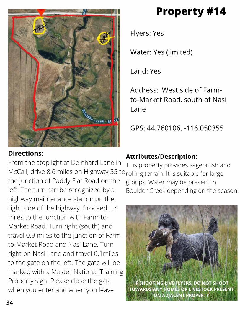
Flyers: Yes
Water: Yes (limited)
Land: Yes
Address: West side of Farm-to-Market Road, south of NasiLane
GPS: 44.760106, -116.050355
Property #14
Directions:From the stoplight at Deinhard Lane inMcCall, drive 8.6 miles on Highway 55 tothe junction of Paddy Flat Road on theleft. The turn can be recognized by ahighway maintenance station on theright side of the highway. Proceed 1.4miles to the junction with Farm-to-Market Road. Turn right (south) andtravel 0.9 miles to the junction of Farm-to-Market Road and Nasi Lane. Turnright on Nasi Lane and travel 0.1milesto the gate on the left. The gate will bemarked with a Master National TrainingProperty sign. Please close the gatewhen you enter and when you leave.
Attributes/Description:This property provides sagebrush androlling terrain. It is suitable for largegroups. Water may be present inBoulder Creek depending on the season.
IF SHOOTING LIVE FLYERS, DO NOT SHOOTTOWARDS ANY HOMES OR LIVESTOCK PRESENT
ON ADJACENT PROPERTY
34

GUN DOGSGUN DOGS HUNT TESTSHUNT TESTS
OBEDIENCEOBEDIENCESHED HUNTINGSHED HUNTING
KODY REYNOLDSKODY REYNOLDSKODY REYNOLDS HAGERMAN, IDHAGERMAN, IDHAGERMAN, ID
775-527-2488775-527-2488775-527-2488 [email protected]@[email protected]
35

Flyers: Yes
Water: No
Land: Yes
Address: Off StonebrakerRoad, near Sugarloaf StatePark
GPS: 44.591355 -116.068299
Property #15
Directions:From McCall: From the south stoplight(Highway 55 & Deinhard Lane), travel21.0 miles south on Highway 55through the towns of Lake Fork andDonnelly to Stonebraker Lane on theright. From Cascade, travel north onHighway 55 for 5.9 miles to StonebrakerLane on the left.Stonebraker Lane serves Lake CascadeState Park-Sugarloaf Unit, so you mayfollow signs toward the park.Travel 1.2miles on Stonebraker Lane to the gateon the right. Approximately 100 yardsprior to the gate, Stonebraker Laneturns sharply left. This is the junctionwith Old Highway 55 (unmarked).Enterthe gate and park. Please close the gatewhen entering and exiting.
Attributes/Description:This property offers a broadhillside of interspersed sage andgrass. It is suitable for largegroups.
IF SHOOTING LIVE FLYERS, DO NOT SHOOTIF SHOOTING LIVE FLYERS, DO NOT SHOOTTOWARDS ANY HOMES OR LIVESTOCKTOWARDS ANY HOMES OR LIVESTOCK
PRESENT ON ADJACENT PROPERTYPRESENT ON ADJACENT PROPERTY
36

Flyers: No
Water: Yes (Limited on #17)
Land: Yes
Address: Off Highway 95,west of Council
GPS: 44.60365, -116.43087
Property #16 & #17
Directions:Please call Maggie Langhorne [phone (925) 980-6335)] to give notice if you want to train onproperties #17 & # 18. She will meet you and have you sign a liability disclaimer beforetraining.From the stoplight on the north side of McCall (Highway 55 & Mission Street), drive north11.5 miles to the junction of Highway 55 and Highway 95 in the city of NewMeadows.Proceed on Highway 95 south to Council, ID. Continue on Highway 95 south 32.7miles to Indian Valley Road. Turn left on Indian Valley Road and proceed 0.1 miles to NorthGrays Creek Road. Turn left on N Grays Creek Road and travel 0.1 miles to Whiteman Lane.Turn right on Whiteman Ln and proceed 0.4 miles to a “T” intersection with Meadow Ln. Turnleft on Meadow Ln and proceed 0.1 miles to a gate on the right that leads to the traininggrounds.Training ground #16 has a pond. The first gate allows access to one side of the pond. If youwish to work from the other side of the pond, do not drive across the ditch. Exit through thegate to Meadow Lane. Take Meadow Lane to the intersection (just short of the red barn) andturn right on the unmarked road. Proceed 50 yards to another gate on the right. This entrywill allow access to the other side of the pond should you wish to work from there.Property #17 is adjacent to property #16 and can be accessed by driving 0.1 miles furtherup the unmarked road to the first driveway to the Langhorne home. Turn into the firstdriveway and proceed straight through the gate.
Attributes/Description:This property provides grass and rolling terrain.
37

Flyers: Yes
Water: No
Land: Yes
Address: Bear Basin Road offHighway 55
GPS: 44.94096, -116.13911
Public Property: Bear Basin
Directions:From the stop light in the north endof McCall (Highway 55 and MissionStreet), travel 2.1 miles north onHighway 55 to Bear Basin Road onthe right. Travel 1.5 miles to a largemeadow on the left. Park on the sideof the road or in established parkingareas.
Attributes/Description:Bear Basin is located on the PayetteNational Forest. It is heavily used bynon-motorized recreationist in thewinter and summer. The area willaccommodate large training groups.However, this is public land andother users must be accommodated.Trainers do not have exclusive use ofthe area.
IF SHOOTING LIVEFLYERS, DO NOT
SHOOT TOWARDSANY HOMES OR
LIVESTOCK PRESENTON ADJACENT
PROPERTY
38
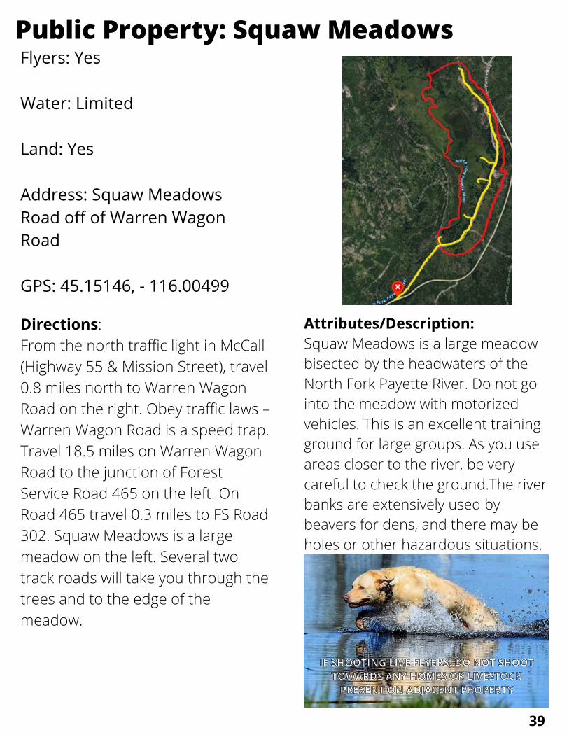
Flyers: Yes
Water: Limited
Land: Yes
Address: Squaw MeadowsRoad off of Warren WagonRoad
GPS: 45.15146, - 116.00499
Public Property: Squaw Meadows
Directions:From the north traffic light in McCall(Highway 55 & Mission Street), travel0.8 miles north to Warren WagonRoad on the right. Obey traffic laws –Warren Wagon Road is a speed trap. Travel 18.5 miles on Warren WagonRoad to the junction of ForestService Road 465 on the left. OnRoad 465 travel 0.3 miles to FS Road302. Squaw Meadows is a largemeadow on the left. Several twotrack roads will take you through thetrees and to the edge of themeadow.
Attributes/Description:Squaw Meadows is a large meadowbisected by the headwaters of theNorth Fork Payette River. Do not gointo the meadow with motorizedvehicles. This is an excellent trainingground for large groups. As you useareas closer to the river, be verycareful to check the ground.The riverbanks are extensively used bybeavers for dens, and there may beholes or other hazardous situations.
IF SHOOTING LIVE FLYERS, DO NOT SHOOTIF SHOOTING LIVE FLYERS, DO NOT SHOOT
TOWARDS ANY HOMES OR LIVESTOCKTOWARDS ANY HOMES OR LIVESTOCKPRESENT ON ADJACENT PROPERTYPRESENT ON ADJACENT PROPERTY
39

Flyers: Yes
Water: Limited
Land: Yes
Address: Off Stonebraker Laneoff Highway 55
GPS: 44.59620, -116.06871
Public Property: Sugarloaf
Directions:From McCall: From the southstoplight (Highway 55 & DeinhardLane), travel 21.0 miles south onHighway 55 through the towns ofLake Fork and Donnelly toStonebraker Lane on the right. From Cascade, travel north onHighway 55 for 5.9 miles toStonebraker Road on the left. Stonebraker Lane serves LakeCascade State Park-Sugarloaf Unit,so you may follow signs toward thepark.Travel 1.1 miles on StonebrakerLane.The road turns sharply left. Thisis the junction with Old Highway 55(unmarked). Park along StonebrakerLane and enter through the foottraffic gate.
Attributes/Description:To the left of the Old Highway is grassand sage. To the right of the old highwayis the lake bed. Depending on how far thelake has been drawn down, water may beavailable on the lake bed. Be sure tocheck the status of blue-green algae inCascade Reservoir if you intend to runyour dogs in the water.This is public land and other users mustbe accommodated. Trainers do not haveexclusive use of the area.
IF SHOOTING LIVE FLYERS, DO NOT SHOOTIF SHOOTING LIVE FLYERS, DO NOT SHOOT
TOWARDS ANY HOMES OR LIVESTOCKTOWARDS ANY HOMES OR LIVESTOCKPRESENT ON ADJACENT PROPERTYPRESENT ON ADJACENT PROPERTY
40

41
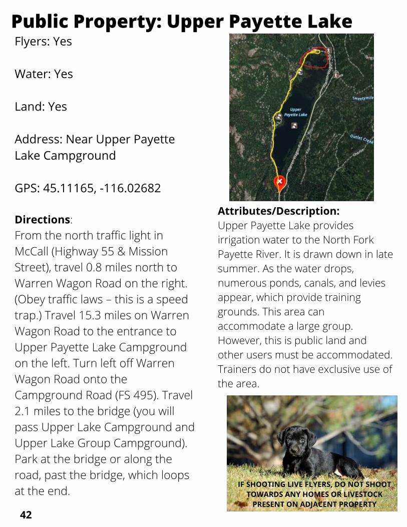
Flyers: Yes
Water: Yes
Land: Yes
Address: Near Upper PayetteLake Campground
GPS: 45.11165, -116.02682
Public Property: Upper Payette Lake
Directions:From the north traffic light inMcCall (Highway 55 & MissionStreet), travel 0.8 miles north toWarren Wagon Road on the right.(Obey traffic laws – this is a speedtrap.) Travel 15.3 miles on WarrenWagon Road to the entrance toUpper Payette Lake Campgroundon the left. Turn left off WarrenWagon Road onto theCampground Road (FS 495). Travel2.1 miles to the bridge (you willpass Upper Lake Campground andUpper Lake Group Campground).Park at the bridge or along theroad, past the bridge, which loopsat the end.
Attributes/Description:Upper Payette Lake providesirrigation water to the North ForkPayette River. It is drawn down in latesummer. As the water drops,numerous ponds, canals, and leviesappear, which provide traininggrounds. This area canaccommodate a large group.However, this is public land andother users must be accommodated.Trainers do not have exclusive use ofthe area.
IF SHOOTING LIVE FLYERS, DO NOT SHOOTTOWARDS ANY HOMES OR LIVESTOCK
PRESENT ON ADJACENT PROPERTY42
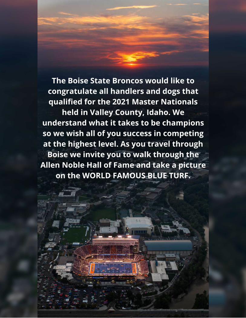
The Boise State Broncos would like tocongratulate all handlers and dogs thatqualified for the 2021 Master Nationals
held in Valley County, Idaho. Weunderstand what it takes to be championsso we wish all of you success in competingat the highest level. As you travel through
Boise we invite you to walk through theAllen Noble Hall of Fame and take a picture
on the WORLD FAMOUS BLUE TURF.


