EAST WEST SOUTHWEST A13 A1 A20 A20 M20 B10 M1 A13 M2 B19 B31 B10 B34 B34 B31 Mount Crawford Forest Information Centre S.E. Fwy Sturt Hwy Port Wakefield Road Main North Road ADELAIDE Hahndorf Balhannah Woodside Lobethal Stirling Crafers Bridgewater Magill Mount Torrens Blackwood Glen Osmond Mitcham Glenelg Grange Port Adelaide Marion Prospect Richmond Nairne Lenswood Norton Summit Outer Harbour Gepps Cross Modbury Athelstone Birdwood Mount Pleasant Gumeracha Kersbrook Williamstown Salisbury Elizabeth Virginia St Kilda Mawson Lakes Gawler Two Wells Lyndoch Tanunda Nuriootpa Angaston Freeling Greenock Roseworthy Eden Valley Cudlee Creek South Para Reservoir Gawler River N 10km S C A L E 0 Total Fire Ban and Forest Closures For your safety, forest reserves are closed to the public on declared Total Fire Ban days and in areas where forest operations such as harvesting are being undertaken. Visitors must keep clear of logging operations and pay attention to all signs. www.forestrysa.com.au Shooting, trapping and other forms of hunting are not permitted within forest reserves. Mount Crawford Forest Information Centre Facilities for Hire Bookings are required for all facilities. Online bookings can be made at www.forestrysa.com.au or enquire at Mount Crawford Forest Information Centre (MCFIC). Old School House A 10.5 km drive from MCFIC with access from Springton Road via Fire Gate MR4. This historic old building is located 450 m from the gate and offers bunk style accommodation for six (bedding required), with a slow combustion heater, kitchen annex, solar lighting, toilet and untreated rainwater with nearby access to the Heysen Trail. Youth Hostel Road (YHA) A 7.5 km drive from MCFIC, with access from Mount Road via Fire Gate BH1. This scenic, secure creekside location is 600 m from the gate with space and privacy for small to medium groups. It has a shelter, picnic table, fire pit, toilet and camping area with nearby access to the Heysen Trail. Centennial Drive A 6 km drive from MCFIC with access from Mount Road via Fire Gate MC 4. This camping area is available primarily to larger school and scout groups, and for special events. The area offers picnic tables, pit toilet, untreated rainwater and a three-sided shelter with a fireplace. Also provides access to the Heysen and the Mount Crawford Summit Trails. This area is currently not available for online booking. Fromms Farm A 4 km drive from MCFIC with access from Mount Road via Fire Gate DW5. Once an old dairy, this large three-sided shelter provides space for medium to large groups offering a fireplace, untreated rainwater, picnic tables and pit toilet. Ponderosa Horse Camp A 9 km drive from MCFIC with access from Starkey Road via Fire Gate DW11. This large campground is set between native and plantation pine forest and is designed for those camping with horses and riders of the Kidman Trail. It offers a small shelter, 4 horse yards, untreated rainwater, picnic tables and a pit toilet. Cromer Shed A 7 km drive from MCFIC with access from Cricks Mill Road (Mt Pleasant Road) via Fire Gate CR3. Drive 400 m north to Fire Gate CR4. The large three-sided shelter is nestled within low, open native vegetation 200 m from the gate. Suitable for small to medium groups offering a fireplace/wood BBQ inside, solar lighting, untreated rainwater and a pit toilet. Mount Crawford Forest Reserve (East Section) Land was first purchased for forestry at Mount Crawford in 1909. Plantings commenced in 1914 and continued to expand until the 1960s. Many of the original plantations have since been clear felled and replanted. Today, the Mount Crawford Forest Reserve covers an area of 12,367 hectares and is modelled as a community forest. It is managed for sustainable commercial forestry, while providing for the conservation of native flora and fauna and community use for recreation. This brochure covers the eastern section of the reserve, which is located between the townships of Williamstown, Mount Pleasant and Forreston. Native Forest Reserves Mount Crawford Forest Reserve contains 4,440 hectares of native vegetation protected for conservation. This includes eight gazetted Native Forest Reserves covering 3,600 hectares. These Native Forest Reserves and conservation zones are of high conservation value, containing a rich variety of trees, shrubs and ground cover species that provide significant habitat for native birds, reptiles and mammals. Native forest areas are an important resource for scientific research and provide opportunities for activities such as nature study, bird watching and bush walking. Pets in the Forest Dogs are welcome in plantation forest areas, provided they are kept under direct control at all times and kept on a leash when in picnic areas or near other forest users or wildlife such as kangaroos. To protect native wildlife, dogs and other pets are not permitted in Native Forest Reserves. Please be aware fox baiting programs are undertaken periodically in Native Forest Reserves as part of regional native wildlife protection programs. For your safety, forest reserves are closed to the public on days of declared total fire ban. Jan Feb Mar Apr May Jun Jul Aug Sep Oct Nov Dec Camping Fires Gas Barbecues = Allowed during that month = Prohibited during that month (on the spot fines apply) This forest is located within the Mount Lofty Ranges Fire Ban District. For CFS fire ban information phone 1300 362 361 or visit the CFS website. Being aware of a Total Fire Ban is your responsibility. Campfires and Barbecues Wood fires are permitted within the forest from 1 May to 31 October each year. Gas fires are permitted from 1 April to 30 November. Fireplaces should be cleared of all flammable material for a distance of 4 metres. Someone must be present at all times and ensure that the fire is fully extinguished before leaving. Visitors may collect wood for campfires from the plantation forest floor only, near their campsites and picnic areas. It is an offence to cut down or damage standing trees or plants. Campfires are restricted to fire places located in campgrounds, picnic areas and at huts. Please conserve wood supplies by keeping fires small. Horse Riding Forests provide extensive opportunities for enjoyable riding in a relaxed environment. Permits and fees apply when riding horses in the forest. Daily, weekly and annual permits are available from MCFIC. The network of existing fire tracks in plantation pine areas is available for riding. Horse riding is not permitted in Native Forest Reserves which have been set aside for conservation. Please avoid picnic areas and campgrounds. Consider the forest trail code on multiple use trails as you may encounter cyclists and walkers during your ride. Using clean feed limits the chances of weeds spreading. Please remove all manure and feed upon departure. Forest Activities and Events Many organised competitions and events are held in Mount Crawford Forest Reserve. These require the submission of an event application and are approved on a case-by-case basis. Such events may include orienteering, mountain biking, horse riding, scout and school camps and organised motorsports. Contact MCFIC for more information. Orienteering There is one permanent orienteering course established within Mount Crawford Forest Reserve in conjunction with the Orienteering Association of South Australia. The course contains an Easy and Moderate level, providing a solid introduction to this popular recreational activity. Course maps are available from MCFIC. Firewood for Household Use Seasoned hardwood (cut & split) and softwood (cut rounds) is available for purchase by the trailer load. To enquire about prices, collection times and availability, contact MCFIC. Mt Crawford Forest Information Centre Warren Road, Williamstown, SA 5351 Office hours: 10am - 12pm (Friday - Sunday only) Phone: (08) 8521 1700 Email: [email protected]Web: www.forestrysa.com.au Postal: Mount Crawford Forest Private Bag Williamstown SA 5351 Certified to Australian Forestry Standard AS 4708 Mt Crawford Fire Lookout Tower Mt Crawford Forest (East) Visitor Information It is an offence to cut down or damage any living or standing vegetation, or to remove any timber from a forest reserve without a permit.
Transcript
EASTWEST
SOUTHWESTA13
A1
A20
A20M20
B10
M1
A13
M2
B19
B31
B10
B34
B34
B31
Mount Crawford Forest Information Centre
S.E.
Fwy
Sturt
Hwy
Port Wakefield
Road
Mai
nN
orth
Roa
d
ADELAIDE
Hahndorf
Balhannah
Woodside
Lobethal
StirlingCrafers
Bridgewater
Magill Mount Torrens
Blackwood
GlenOsmond
MitchamGlenelg
Grange
PortAdelaide
Marion
Prospect
Richmond
Nairne
LenswoodNortonSummit
OuterHarbour
GeppsCross
Modbury
Athelstone
Birdwood
MountPleasant
Gumeracha
Kersbrook
Williamstown
Salisbury
Elizabeth
Virginia
St Kilda
MawsonLakes
GawlerTwo WellsLyndoch
Tanunda
Nuriootpa
Angaston
Freeling Greenock
Roseworthy
EdenValley
Cudlee Creek
South ParaReservoir
GawlerRiver
N10km
S C A L E
0
Total Fire Ban and Forest ClosuresFor your safety, forest reserves are closed to the public on declared Total Fire Ban days and in areas where forest operations such as harvesting are being undertaken. Visitors must keep clear of logging operations and pay attention to all signs.
www.forestrysa.com.au
Shooting, trapping and other forms of hunting are not permitted within
forest reserves.
Mount Crawford Forest Information Centre
Facilities for HireBookings are required for all facilities. Online bookings can be made at www.forestrysa.com.au or enquire at Mount Crawford Forest Information Centre (MCFIC).
Old School HouseA 10.5 km drive from MCFIC with access from Springton Road via Fire Gate MR4. This historic old building is located 450 m from the gate and offers bunk style accommodation for six (bedding required), with a slow combustion heater, kitchen annex, solar lighting, toilet and untreated rainwater with nearby access to the Heysen Trail.
Youth Hostel Road (YHA)A 7.5 km drive from MCFIC, with access from Mount Road via Fire Gate BH1. This scenic, secure creekside location is 600 m from the gate with space and privacy for small to medium groups. It has a shelter, picnic table, fire pit, toilet and camping area with nearby access to the Heysen Trail.
Centennial DriveA 6 km drive from MCFIC with access from Mount Road via Fire Gate MC 4. This camping area is available primarily to larger school and scout groups, and for special events. The area offers picnic tables, pit toilet, untreated rainwater and a three-sided shelter with a fireplace. Also provides access to the Heysen and the Mount Crawford Summit Trails. This area is currently not available for online booking.
Fromms FarmA 4 km drive from MCFIC with access from Mount Road via Fire Gate DW5. Once an old dairy, this large three-sided shelter provides space for medium to large groups offering a fireplace, untreated rainwater, picnic tables and pit toilet.
Ponderosa Horse CampA 9 km drive from MCFIC with access from Starkey Road via Fire Gate DW11. This large campground is set between native and plantation pine forest and is designed for those camping with horses and riders of the Kidman Trail. It offers a small shelter, 4 horse yards, untreated rainwater, picnic tables and a pit toilet.
Cromer ShedA 7 km drive from MCFIC with access from Cricks Mill Road (Mt Pleasant Road) via Fire Gate CR3. Drive 400 m north to Fire Gate CR4. The large three-sided shelter is nestled within low, open native vegetation 200 m from the gate. Suitable for small to medium groups offering a fireplace/wood BBQ inside, solar lighting, untreated rainwater and a pit toilet.
Mount Crawford Forest Reserve (East Section)Land was first purchased for forestry at Mount Crawford in 1909. Plantings commenced in 1914 and continued to expand until the 1960s. Many of the original plantations have since been clear felled and replanted.
Today, the Mount Crawford Forest Reserve covers an area of 12,367 hectares and is modelled as a community forest. It is managed for sustainable commercial forestry, while providing for the conservation of native flora and fauna and community use for recreation.
This brochure covers the eastern section of the reserve, which is located between the townships of Williamstown, Mount Pleasant and Forreston.
Native Forest ReservesMount Crawford Forest Reserve contains 4,440 hectares of native vegetation protected for conservation. This includes eight gazetted Native Forest Reserves covering 3,600 hectares.
These Native Forest Reserves and conservation zones are of high conservation value, containing a rich variety of trees, shrubs and ground cover species that provide significant habitat for native birds, reptiles and mammals.
Native forest areas are an important resource for scientific research and provide opportunities for activities such as nature study, bird watching and bush walking.
Pets in the ForestDogs are welcome in plantation forest areas, provided they are kept under direct control at all times and kept on a leash when in picnic areas or near other forest users or wildlife such as kangaroos.
To protect native wildlife, dogs and other pets are not permitted in Native Forest Reserves.
Please be aware fox baiting programs are undertaken periodically in Native Forest Reserves as part of regional native wildlife protection programs.
For your safety, forest reserves are closed to the public on days of declared total fire ban.
Jan Feb Mar Apr May Jun Jul Aug Sep Oct Nov DecCampingFiresGas Barbecues
= Allowed during that month= Prohibited during that month (on the spot fines apply)
This forest is located within the Mount Lofty Ranges Fire Ban District. For CFS fire ban information phone 1300 362 361 or visit the CFS website. Being aware of a Total Fire Ban is your responsibility.
Campfires and BarbecuesWood fires are permitted within the forest from 1 May to 31 October each year. Gas fires are permitted from 1 April to 30 November.
Fireplaces should be cleared of all flammable material for a distance of 4 metres. Someone must be present at all times and ensure that the fire is fully extinguished before leaving.
Visitors may collect wood for campfires from the plantation forest floor only, near their campsites and picnic areas.
It is an offence to cut down or damage standing trees or plants. Campfires are restricted to fire places located in campgrounds, picnic areas and at huts. Please conserve wood supplies by keeping fires small.
Horse RidingForests provide extensive opportunities for enjoyable riding in a relaxed environment. Permits and fees apply when riding horses in the forest. Daily, weekly and annual permits are available from MCFIC.
The network of existing fire tracks in plantation pine areas is available for riding. Horse riding is not permitted in Native Forest Reserves which have been set aside for conservation.
Please avoid picnic areas and campgrounds. Consider the forest trail code on multiple use trails as you may encounter cyclists and walkers during your ride. Using clean feed limits the chances of weeds spreading. Please remove all manure and feed upon departure.
Forest Activities and EventsMany organised competitions and events are held in Mount Crawford Forest Reserve. These require the submission of an event application and are approved on a case-by-case basis.
Such events may include orienteering, mountain biking, horse riding, scout and school camps and organised motorsports. Contact MCFIC for more information.
OrienteeringThere is one permanent orienteering course established within Mount Crawford Forest Reserve in conjunction with the Orienteering Association of South Australia.
The course contains an Easy and Moderate level, providing a solid introduction to this popular recreational activity. Course maps are available from MCFIC.
Firewood for Household UseSeasoned hardwood (cut & split) and softwood (cut rounds) is available for purchase by the trailer load. To enquire about prices, collection times and availability, contact MCFIC.
Mt Crawford Forest Information CentreWarren Road, Williamstown, SA 5351
It is an offence to cut down or damage any living or standing vegetation, or to remove any timber from a forest reserve without a permit.
VineyardMountadam
Tower
Scotts Shelter(Heysen Trail)
Cromer
Chalks
FrommsFarmFire Lookout
Tower 525 m
Historicplantings1922
Sailors Gully
Rocky Paddock
JenkinsNature Trail
MountCrawford Forest
InformationCentre
Arboretum
CentennialDrive
Cemetery and OldChurch Ruin
The OldSchoolHouse
Historicplanting 1914
Historicplanting 1916
Historicplanting 1924
MountPleasant
Peter SeppeltGrand Cru
Estate
Malcolm CreekVineyard
RoachdaleNature
Trail
Police
Police
MOUNT CRAWFORDFOREST RESERVE
Gold was discovered at Watts Gully in 1884, followed by smaller
discoveries in Sailors, Speck, Dead Horse and Blood and Thunder
gullies. Opal, garnet and other gems have been located in the reserve. Fossicking permits are available.
Cromer Shed
Ponderosa
PonderosaHorseCamp
TalungaPark
Queen VictoriaJubilee Park
YHA Road
Heysen Trail
Trail
Heys
en
Trail
Mawso
n
Kidm
an T
rail M
awson Trail
Kidman Trail
Mt CrawfordSummit Trail
Warr
en
To
wer Hike
Warren Tower
Hike
Mt PleasantSummit Trail
Circuit1
Circuit2
Circuit3
Big Flat Trail
Big F
lat T
railDewells Trail
Dewells
Trail
HeadquartersLoop 2
HeadquartersLoop 1
Mount RoadTrailhead
Dry weathercreek crossing
SA Water ReserveNO PUBLIC ENTRY
SA Water ReserveNO PUBLIC ENTRY
SA Water ReserveNO PUBLIC ENTRY
HaleConservation
Park
CromerConservation
Park
WarrenConservation
Park
Stony
Rive
r
Para
Sout
h
ReservoirBarossa
Torrens
Rive
r
WarrenReservoir
South ParaReservoir
LittleMt Crawford525 m
MtPleasant
543 m
Mt Crawford562 m
Rd
YHA
Rd
Norsw
orthy
MewittRoad
Rd
Walpole
RdCreekRocky
Tower
Rd
Chalks
Road
For
ties
Rd
Rd
Ridge
Three
Break
Chain
Road
Roa
d
Needles Road
Rd
Rd
Roa
d
Wirr
aW
irra
Rd
wood
Black
Mount
Canham
Yettie
Leskes Rd
Cro
mer
Roa
d
Road
Telephone
Tun
gali
Gottwald
Road
Hooper
Road
Gully
Roa
dS
tark
ey
RdPark
Corryton
Cow
ell
Lorke Rd
Miamba
Road
RdHit
Luck
y
Roa
dS
nake
Bla
ck
Quinns
Roa
dS
mith
Road
Rd
Rd
Hill
High
Eden
Road
Roa
d
Road
Devon
Glen
Roa
d
McB
ean
Road
Fre
nchs
Road
Springs
Boehms
Road
Craneford
Roa
dR
ange
McB
eans
RoadHill
Checker
Rd
Roa
d
St
Wild
Watts
Road
SouthTce
Rozenweig Rd
Baynes Gully R
d
Spe ck
Gully Rd
Ale
xander Forrest R
d
RO
AD
PA
RA
LIT
TL
E
ROAD
RO
AD
ROAD
MILL
CRICKS
ROAD
RO
AD
ROAD
WA
RR
EN
RO
AD
RO
AD
ROAD
ROAD
SPRINGTON
FORRESTON
WA
RR
EN
RO
AD
VALLEY
TORRENS
SPRINGTON
Cromer
Forreston
Mount Pleasant
Williamstown
Kersbrook
B31
B31
B31
B10
B34
B34
B34
B35
B35
B35
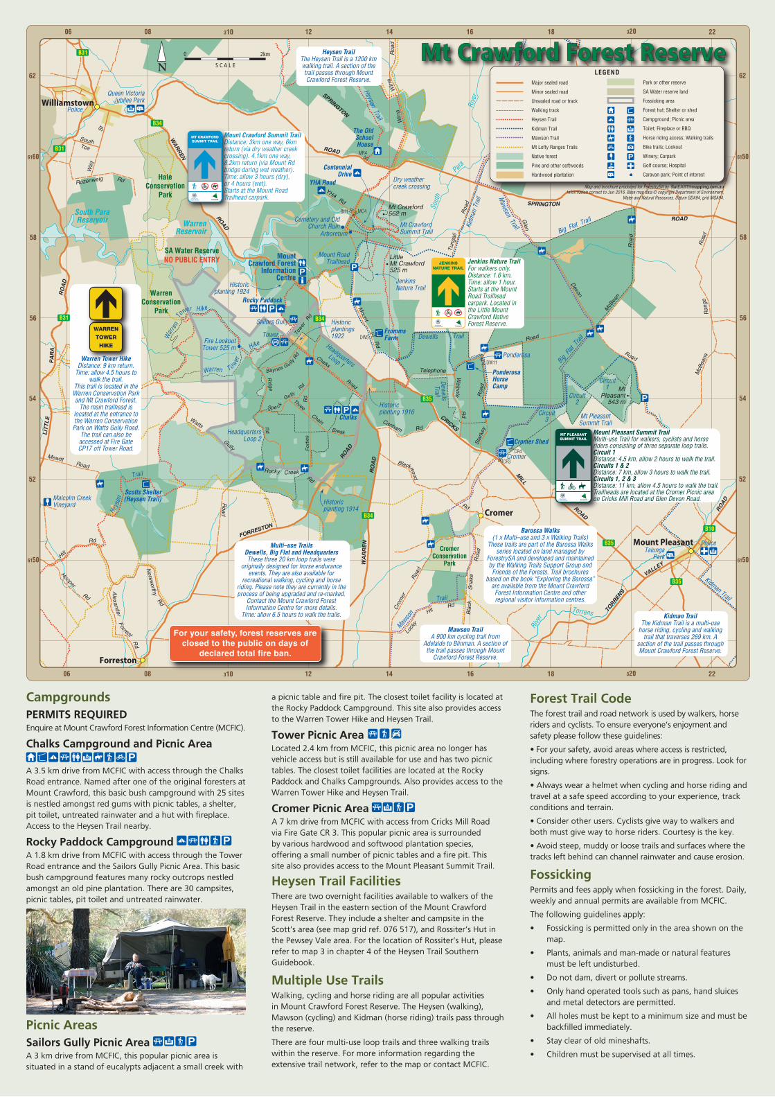
B31 Heysen TrailThe Heysen Trail is a 1200 km walking trail. A section of the trail passes through Mount Crawford Forest Reserve.
Kidman TrailThe Kidman Trail is a multi-use
horse riding, cycling and walking trail that traverses 269 km. A
section of the trail passes through Mount Crawford Forest Reserve.
Mawson TrailA 900 km cycling trail from
Adelaide to Blinman. A section of the trail passes through Mount
Crawford Forest Reserve.
Mount Crawford Summit TrailDistance: 3km one way, 6km return (via dry weather creek crossing). 4.1km one way, 8.2km return (via Mount Rd bridge during wet weather).Time: allow 3 hours (dry),or 4 hours (wet).Starts at the Mount Road Trailhead carpark.
Jenkins Nature TrailFor walkers only.Distance: 1.6 km.Time: allow 1 hour.Starts at the Mount Road Trailhead carpark. Located in the Little Mount Crawford Native Forest Reserve.
Warren Tower HikeDistance: 9 km return.
Time: allow 4.5 hours to walk the trail.
This trail is located in the Warren Conservation Park and Mt Crawford Forest.
The main trailhead is located at the entrance to the Warren Conservation
Park on Watts Gully Road. The trail can also be accessed at Fire Gate CP17 off Tower Road.
Mount Pleasant Summit TrailMulti-use Trail for walkers, cyclists and horse riders consisting of three separate loop trails.Circuit 1Distance: 4.5 km, allow 2 hours to walk the trail.Circuits 1 & 2 Distance: 7 km, allow 3 hours to walk the trail.Circuits 1, 2 & 3 Distance: 11 km, allow 4.5 hours to walk the trail.Trailheads are located at the Cromer Picnic area on Cricks Mill Road and Glen Devon Road.
MT PLEASANT SUMMIT TRAIL
Barossa Walks(1 x Multi–use and 3 x Walking Trails)
These trails are part of the Barossa Walks series located on land managed by
ForestrySA and developed and maintained by the Walking Trails Support Group and
Friends of the Forests. Trail brochures based on the book “Exploring the Barossa”
are available from the Mount Crawford Forest Information Centre and other regional visitor information centres.
Multi–use TrailsDewells, Big Flat and Headquarters These three 20 km loop trails were
originally designed for horse endurance events. They are also available for
recreational walking, cycling and horse riding. Please note they are currently in the process of being upgraded and re-marked.
Contact the Mount Crawford Forest Information Centre for more details.
Water and Natural Resources. Datum GDA94, grid MGA94.
LEGENDMajor sealed road
Minor sealed road
Unsealed road or track
Walking track
Heysen Trail
Kidman Trail
Mawson Trail
Mt Lofty Ranges Trails
Native forest
Pine and other softwoods
Hardwood plantation
Park or other reserve
SA Water reserve land
Fossicking area
Forest hut; Shelter or shed
Campground; Picnic area
Toilet; Fireplace or BBQ
Horse riding access; Walking trails
Bike trails; Lookout
Winery; Carpark
Golf course; Hospital
Caravan park; Point of interest
For your safety, forest reserves are closed to the public on days of
declared total fire ban.
JENKINSNATURE TRAIL
MT CRAWFORD SUMMIT TRAIL
Campgrounds PERMITS REQUIREDEnquire at Mount Crawford Forest Information Centre (MCFIC).
Chalks Campground and Picnic Area
A 3.5 km drive from MCFIC with access through the Chalks Road entrance. Named after one of the original foresters at Mount Crawford, this basic bush campground with 25 sites is nestled amongst red gums with picnic tables, a shelter, pit toilet, untreated rainwater and a hut with fireplace. Access to the Heysen Trail nearby.
Rocky Paddock CampgroundA 1.8 km drive from MCFIC with access through the Tower Road entrance and the Sailors Gully Picnic Area. This basic bush campground features many rocky outcrops nestled amongst an old pine plantation. There are 30 campsites, picnic tables, pit toilet and untreated rainwater.
Picnic AreasSailors Gully Picnic AreaA 3 km drive from MCFIC, this popular picnic area is situated in a stand of eucalypts adjacent a small creek with
a picnic table and fire pit. The closest toilet facility is located at the Rocky Paddock Campground. This site also provides access to the Warren Tower Hike and Heysen Trail.
Tower Picnic AreaLocated 2.4 km from MCFIC, this picnic area no longer has vehicle access but is still available for use and has two picnic tables. The closest toilet facilities are located at the Rocky Paddock and Chalks Campgrounds. Also provides access to the Warren Tower Hike and Heysen Trail.
Cromer Picnic AreaA 7 km drive from MCFIC with access from Cricks Mill Road via Fire Gate CR 3. This popular picnic area is surrounded by various hardwood and softwood plantation species, offering a small number of picnic tables and a fire pit. This site also provides access to the Mount Pleasant Summit Trail.
Heysen Trail FacilitiesThere are two overnight facilities available to walkers of the Heysen Trail in the eastern section of the Mount Crawford Forest Reserve. They include a shelter and campsite in the Scott’s area (see map grid ref. 076 517), and Rossiter’s Hut in the Pewsey Vale area. For the location of Rossiter’s Hut, please refer to map 3 in chapter 4 of the Heysen Trail Southern Guidebook.
Multiple Use TrailsWalking, cycling and horse riding are all popular activities in Mount Crawford Forest Reserve. The Heysen (walking), Mawson (cycling) and Kidman (horse riding) trails pass through the reserve.
There are four multi-use loop trails and three walking trails within the reserve. For more information regarding the extensive trail network, refer to the map or contact MCFIC.
Forest Trail CodeThe forest trail and road network is used by walkers, horse riders and cyclists. To ensure everyone’s enjoyment and safety please follow these guidelines:
• For your safety, avoid areas where access is restricted, including where forestry operations are in progress. Look for signs.
• Always wear a helmet when cycling and horse riding and travel at a safe speed according to your experience, track conditions and terrain.
• Consider other users. Cyclists give way to walkers and both must give way to horse riders. Courtesy is the key.
• Avoid steep, muddy or loose trails and surfaces where the tracks left behind can channel rainwater and cause erosion.
FossickingPermits and fees apply when fossicking in the forest. Daily, weekly and annual permits are available from MCFIC.
The following guidelines apply:
• Fossicking is permitted only in the area shown on the map.
• Plants, animals and man-made or natural features must be left undisturbed.
• Do not dam, divert or pollute streams.
• Only hand operated tools such as pans, hand sluices and metal detectors are permitted.
• All holes must be kept to a minimum size and must be backfilled immediately.