Boundary Hydroelectric Project (FERC No. 2144) Study No. 20 Bat Surveys and Habitat Inventory Final Report Prepared for Seattle City Light Prepared by Gregory A. Green, Jessica Piasecke, and Steve Negri Tetra Tech March 2009
Transcript
Boundary Hydroelectric Project (FERC No. 2144)
Study No. 20
Bat Surveys and Habitat Inventory
Final Report
Prepared for Seattle City Light
Prepared by Gregory A. Green, Jessica Piasecke, and Steve Negri
Tetra Tech
March 2009
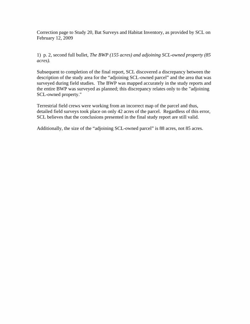
Correction page to Study 20, Bat Surveys and Habitat Inventory, as provided by SCL on February 12, 2009 1) p. 2, second full bullet, The BWP (155 acres) and adjoining SCL-owned property (85 acres). Subsequent to completion of the final report, SCL discovered a discrepancy between the description of the study area for the “adjoining SCL-owned parcel” and the area that was surveyed during field studies. The BWP was mapped accurately in the study reports and the entire BWP was surveyed as planned; this discrepancy relates only to the "adjoining SCL-owned property." Terrestrial field crews were working from an incorrect map of the parcel and thus, detailed field surveys took place on only 42 acres of the parcel. Regardless of this error, SCL believes that the conclusions presented in the final study report are still valid. Additionally, the size of the “adjoining SCL-owned parcel” is 88 acres, not 85 acres.
FINAL REPORT STUDY NO. 20 – BAT SURVEYS AND HABITAT INVENTORY
Boundary Hydroelectric Project Seattle City Light FERC No. 2144 i March 2009
2 Study Objectives.......................................................................................................................1
3 Study Area ................................................................................................................................1
4 Methods.....................................................................................................................................4 4.1. Information Update...........................................................................................................4 4.2. Inventory and Characterization of Bat Habitats................................................................4 4.3. Roost Site and Maternity Colony Surveys........................................................................5 4.4. Hibernacula Surveys .........................................................................................................5 4.5. Foraging Site Sampling.....................................................................................................6 4.6. Tree Roost Mapping .........................................................................................................7 4.7. Documentation and Effects Assessment...........................................................................7
5 Results .......................................................................................................................................7 5.1. Information Update...........................................................................................................7 5.2. Inventory and Characterization of Bat Habitats..............................................................13 5.3. Roost Site and Maternity Colony Surveys......................................................................18 5.4. Hibernacula Surveys .......................................................................................................22 5.5. Foraging Site Sampling...................................................................................................22 5.6. Tree Roost Mapping .......................................................................................................23 5.7. Effects Assessment .........................................................................................................27
FINAL REPORT STUDY NO. 20 – BAT SURVEYS AND HABITAT INVENTORY
Boundary Hydroelectric Project Seattle City Light FERC No. 2144 ii March 2009
List of Tables Table 5.1-1. Bat species potentially occurring in the study area. .................................................. 8 Table 5.1-2. Locations of mines in the Project vicinity with potentially suitable bat habitat,
determination of occurrence within the study area, and linear distances to the reservoir high-water line (1,994 feet NAVD 88 [1,990 feet NGVD 29]). ................................................... 10
Table 5.5-1. Bat species identified acoustically at eight foraging sites surveyed in the study area. ....................................................................................................................................... 23
List of Figures Figure 3.0-1. Study area for the Bat Study. ................................................................................... 3 Figure 5.1-1. Locations of mines within and nearby the study area. ........................................... 11 Figure 5.2-1. Locations of sites surveyed for bat use. ................................................................. 15 Figure 5.3-1. Researcher at entrance to Washington Mine.......................................................... 20 Figure 5.6-1. Sand Creek cottonwood snags potentially used as bat roosts. ............................... 25 Figure 5.6-2. Sullivan Creek cottonwood snags potentially used as bat roosts. .......................... 26
Boundary Hydroelectric Project Seattle City Light FERC No. 2144 1 March 2009
Study No. 20: Bat Surveys and Habitat Inventory Final Report
Boundary Hydroelectric Project (FERC No. 2144)
1 INTRODUCTION
Study No. 20, the Bat Surveys and Habitat Inventory Study (Bat Study), was conducted in support of the relicensing of the Boundary Hydroelectric Project (Project), Federal Energy Regulatory Commission (FERC) No. 2144, as identified in the Revised Study Plan (RSP; SCL 2007) submitted by Seattle City Light (SCL) on February 14, 2007, and approved by FERC in its Study Plan Determination letter dated March 15, 2007. This report describes the field efforts, analyses, and determination of Project effects and represents the completion of the study.
2 STUDY OBJECTIVES
The primary goal of the Bat Study was to provide information needed to determine the presence of bat species and/or their important habitats in the Project vicinity, and assess ongoing Project effects on these species. Specific objectives of the study were to:
• Document bat species occurrence in the Project vicinity. • Inventory and characterize structures potentially used for day roosting, night roosting,
maternity colonies, and hibernacula. • Document use of selected structures during the breeding and winter hibernation time
periods. • Assess the level of use of selected foraging areas (e.g., the Boundary Wildlife
Preserve [BWP]). • Identify threats to bat species or habitats, including potential Project effects.
3 STUDY AREA
The study area for the Bat Study extended approximately 18 miles along the Pend Oreille River from the Box Canyon tailrace downstream to the U.S.-Canada border (Figure 3.0-1) and encompassed the following:
• Downstream of Metaline Falls—The reservoir, fluctuation zone (forebay elevation 1,954–1,994 feet NAVD 88 [1,950–1,990 feet NGVD 291]) allowed under the current
1SCL is in the process of converting all Project information from an older elevation datum (National Geodetic Vertical Datum of 1929 [NGVD 29]) to a more recent elevation datum (North American Vertical Datum of 1988 [NAVD 88]). As such, elevations are provided relative to both data throughout this document. The conversion factor between the old and new data is approximately 4 feet (e.g., the crest of the dam is 2,000 feet NGVD 29 and 2,004 feet NAVD 88).
FINAL REPORT STUDY NO. 20 – BAT SURVEYS AND HABITAT INVENTORY
Boundary Hydroelectric Project Seattle City Light FERC No. 2144 2 March 2009
license, and the land within the FERC Project boundary (Project area), which includes most Project facilities, the area 200 horizontal feet (i.e., along the ground surface, perpendicular to the shoreline) beyond the high water level (forebay elevation 1,994 feet NAVD 88 [1,990 feet NGVD 29]) along both reservoir shorelines, and the transmission line right-of-way from the powerhouse to the Bonneville Power Administration interconnection.2 For clarification on the types of activities to be conducted from forebay elevations 1,954–1,974 feet NAVD 88 [1,950–1,970 feet NGVD 29]), please refer to the RSP, Task 2, last paragraph (SCL 2007).
• Upstream of Metaline Falls―The reservoir fluctuation zone (approximately 1,986 - 2,020 feet NAVD 88 [1,982–2,016 feet NGVD 29], based on hourly records from 1987 through 2005 at the U.S. Geological Survey [USGS] gage below Box Canyon Dam), and the land within approximately 200 horizontal feet of the high water level (approximately 2,020 feet NAVD 88 [2,016 feet NGVD 29]) along both reservoir shorelines extending to the FERC project boundary for the Box Canyon Project.3,4
• The BWP (155 acres) and adjoining SCL-owned property (85 acres). • 100 feet around any Project works areas that extend outside the Project boundary. • Land within 100 horizontal feet along both sides of the river from Boundary Dam to
the U.S.-Canada border (approximately 0.9 mile). The range of water surface elevations recorded during the survey periods for this study is presented below and represents typical operating conditions for the period in which field data were collected. Existing conditions at the time of surveys were considered adequate to acquire all data required for this study:
• From Box Canyon Dam to Metaline Falls―Elevation 1,988–2,003 feet NAVD 88 (1,984–1,999 feet NGVD 29), as measured at the USGS gage 12396500 (surveys to identify potential bat habitat were not targeted for the fluctuation zone in this area).
• From Metaline Falls to Boundary Dam―Elevation 1,987–1,993 feet NAVD 88 (1,983–1,989 feet NGVD 29), as measured at the SCL gage located in the Boundary forebay. The bat habitat survey for this section of the reservoir was conducted during a drawdown event on September 6, 2007. During the survey, water surface elevations were at or below 1,974 feet NAVD 88 (1,970 feet NGVD 29), as measured at the SCL gage located in the Boundary forebay.
2Per Task 5 of the RSP, SCL conducted bat foraging surveys in representative habitats throughout the study area. The reader will note that on Figure 5.2-1 in the vicinity of Monument Bar, the site surveyed falls just outside of the study area. The survey crew was not able to locate a site in that vicinity within the study area that could accommodate the placement of the mist nets. SCL considers the data collected at this location to be suitable to interpret the effectiveness of the area to support foraging bats. 3As indicated in this and other study reports in the Updated Study Report, SCL agreed it is appropriate to study the existing fluctuation range of the reservoir; however, for development of the Preliminary Licensing Proposal (PLP) and License Application, SCL will base its assessment of potential protection, mitigation, and enhancement measures on that portion of the fluctuation zone that is determined to be under the influence of Boundary Project operations, versus the effects of inflows and Metaline Falls that are beyond the control of the Project. 4Data for the riparian zone downstream of the Box Canyon Dam located within the FERC project boundary for the Box Canyon Project (FERC #2042) are included in this report; however, in the development of the PLP and License Application, SCL’s assessment of potential protection, mitigation, and enhancement efforts will be limited to those effects that are determined to be under the influence of Boundary Project operations.
LegendRoadsStreamsWaterbodiesStudy Area BoundaryExisting Project Boundary
Unpublished Work Copyright 2008 Seattle City Light
Map Version 01/28/08Washington
ProjectLocation
FINAL REPORT STUDY NO. 20 – BAT SURVEYS AND HABITAT INVENTORY
Boundary Hydroelectric Project Seattle City Light FERC No. 2144 4 March 2009
4 METHODS
Seven tasks were identified for this study: • Task 1: Information update • Task 2: Inventory and characterization • Task 3: Roost site and maternity colony surveys • Task 4: Hibernacula surveys • Task 5: Foraging site sampling • Task 6: Tree roost mapping • Task 7: Documentation and effects assessment
The methodologies for these tasks are described in detail below. 4.1. Information Update
This task involved updating the information provided in the RSP on bat species potentially inhabiting the study area, potential roost sites, and hibernacula. Species information provided in the RSP was verified by consulting available literature on the distribution and habitat use of bats. Additional site-specific information relative to the study area was obtained from the U.S. Forest Service (USFS; Mike Borysewicz), Bureau of Land Management (BLM; Nancy Williams), and Washington Department of Fish and Wildlife (WDFW; Dana Base and Howard Ferguson). The USFS provided a list of 32 potential bat use sites (24 mines, 7 caves, and 1 bridge) in the vicinity of the Project. For approximately half of these sites, the location information was missing or lacking in the detail needed to accurately map the sites and determine if they were within the study area. Additional location data for these sites was requested from the USFS, but more accurate information did not exist. Subsequently, additional sources were consulted, including the U.S. Environmental Protection Agency (EPA) Comprehensive Environmental Response, Compensation and Liability Act (CERCLA) reports (E&E 2002), the Washington Department of Ecology (Ecology) abandoned mines lands investigation reports (Hart Crowser 2006, 2007), and the USGS minerals resource database (Boleneus 1999). Despite the lack of detailed location data, SCL believes that the intensive field efforts resulted in the location of all caves and adits in the study area that could potentially serve as bat habitat. 4.2. Inventory and Characterization of Bat Habitats
For this study, potential bat roosting, hibernacula, and maternity colony sites were defined as caves and mines that are relatively isolated or undisturbed and not regularly flooded, and that provide protection from predators and the elements. Some Project-related structures such as dam tunnels, portals, and maintenance buildings were considered to be potential roosting, hibernacula, and maternity colony sites. All sites identified in Task 1 as potentially suitable bat habitat, as well as additional sites observed in the field, were investigated. Each of these sites was visited, mapped using a Global
FINAL REPORT STUDY NO. 20 – BAT SURVEYS AND HABITAT INVENTORY
Boundary Hydroelectric Project Seattle City Light FERC No. 2144 5 March 2009
Positioning System (GPS) unit, characterized, and photographed. Data collected at each site included temperature, humidity, opening size, evidence of disturbance, and vegetation present. Based on site characteristics, the bat species likely to use each site were identified, and each site’s potential for providing maternal colony or hibernating habitat was assessed. Lastly, the need for bat occurrence surveys was determined. During a study-related reservoir drawdown on September 6, 2007, a survey was conducted of mine adits and caves occurring in the fluctuation zone down to elevation 1,974 feet NAVD 88 (1,970 feet NGVD 29). The purpose of the survey was to determine if additional habitat for bats might be available if the reservoir were to be maintained at a lower water surface elevation. In addition, pre-construction photographs (SCL 1966) and bathymetry maps were examined to determine the number of caves and mine adits occurring between 1,954 feet and 1,974 feet NAVD 88 (1,950 feet and 1,970 feet NGVD 29) in the lower reservoir that might represent potential bat habitat. This exercise focused on the portion of the study area between Metaline Falls and Boundary Dam because this section of the reservoir contains the most potentially suitable habitat. 4.3. Roost Site and Maternity Colony Surveys
Nocturnal emergence/dispersal surveys (Kunz et al. 1996), also known as visual exit surveys, were conducted to identify bat use of potential roosting or maternity sites at locations identified in Task 2. Surveys were conducted from 30 minutes before sunset until 2 hours after sunset (Tuttle and Taylor 1998). Field staff sat quietly close to the entrance of the cave or mine, to minimize disturbance to bats, and used tally counters to keep track of bat exits and entrances. The difference between the “exit” and “entrance” counts during each survey period was used as an estimate of the number of individual bats using the site. Bat calls were also recorded to identify bat species because most can be difficult or impossible to identify by sight alone in low light conditions. Pettersson 240x ultrasonic sound detectors (Pettersson Elektronik AB, Uppsala, Sweden) and iRiver digital recorders (iRiver, Seoul, Korea) were used to collect echolocation call data. The call data were later analyzed using SonoBat bat call analysis software (SonoBat, Arcata, California). At sites where the potential for bat use was considered low, such as some of the tunnels and portals associated with Boundary Dam and powerhouse, initial surveys were conducted with acoustical bat detectors only. If bats were acoustically detected, a visual exit survey was conducted the following night. The portals and tunnels associated with Boundary Dam and powerhouse were surveyed during the day using flashlights to investigate cracks and crevices in the ceilings and upper walls of these structures. In addition, two caves in the Canyon Reach, which extends from Metaline Falls to the downstream end of Z Canyon (Project river mile [PRM] 26.8 to 18.0), were also surveyed, both acoustically and visually. Surveys of potential roost and maternity colony sites were conducted in June and August 2007. 4.4. Hibernacula Surveys
From information gathered in Tasks 1 and 2, three potential winter hibernacula (Metaline and Washington mines and the Thurman exploratory adit) were identified in the study area. These sites were then surveyed in September and October 2007 for the presence of swarming bats,
FINAL REPORT STUDY NO. 20 – BAT SURVEYS AND HABITAT INVENTORY
Boundary Hydroelectric Project Seattle City Light FERC No. 2144 6 March 2009
which can be indicative of use as a winter hibernaculum (Vonhof and Gwilliam 2000). Data collected at these sites included temperature, relative humidity, and air flow. Visual exit surveys of the entrances were conducted beginning one half hour before sunset and ending two hours after sunset, and ultrasonic detectors were used to collect call data. Recordings were later analyzed using SonoBat. 4.5. Foraging Site Sampling
Eight sites in the study area (see Figure 5.2-1) were identified as representing potential bat foraging habitat. Mist nets were used to survey for the presence of foraging bats at all these sites except one (see #8 below). The eight sites are described below:
1. The Sullivan Creek site is located on a dike at the edge of the Sullivan Creek wetland. Common snowberry (Symphoricarpus albus), reed canarygrass (Phalaris arundinacea), and willow (Salix spp.) are the main plant species present. This site was surveyed on July 24, 2007; two mist nets were stretched across the dike.
2. The Boundary Forebay site is located at the western edge of the Forebay Recreation
Area. One net was stretched under two cottonwood trees near the southwest corner of the Ross Cabin, while a second net was placed across the southern front of the cabin; this site was surveyed on July 25, 2007.
3. The BWP site is located at the head of the BWP slough. Two nets were placed in a
v-pattern at the head of a small pond at the southern end of the slough, and a third net was placed upslope of the pond at the edge of a quaking aspen (Populus tremuloides) stand. The site was surveyed on July 26, 2007.
4. The Monument Bar site is located just north of Monument Bar within a second-
growth conifer stand. On August 15, 2007, two nets were placed across a USFS road in the vicinity of Monument Bar; a third was placed on a spur road heading west toward the river, approximately 75 feet away from the other two nets (see footnote 2 in Section 3, Study Area).
5. The Boundary Tailrace site is located in riparian habitat downstream of Boundary
Dam on the east side of the river. Two nets were placed in a v-pattern near an old mining cabin (Schierding) site, and a third net was placed across the very end of USFS Road 200 on July 27, 2007.
6. The Box Canyon site is located in a stand of cottonwood trees on the east side of the
river just below Box Canyon Dam. Three mist nets were placed in gaps between trees that are possible flyways; this site was surveyed on August 17, 2007 (see footnote 4 in Section 3, Study Area).
7. The Lime Creek site is located at the mouth of Lime Creek where a series of
cascading pools and shrubby riparian habitat border a forested wetland. Three mist
FINAL REPORT STUDY NO. 20 – BAT SURVEYS AND HABITAT INVENTORY
Boundary Hydroelectric Project Seattle City Light FERC No. 2144 7 March 2009
nets were placed across the mouth of the braided stream just before it enters the reservoir embayment. The site was surveyed on August 16, 2007.
8. Metaline Pool is a wide, slower stretch of the Pend Oreille River just upstream of
Metaline Falls. Due to the slower water velocity, aquatic weed beds have become established, potentially supporting large numbers of emergent aquatic insects. On the night of July 17, 2008, a detector was placed on the shoreline, aimed over the water of Metaline Pool, with the intention of determining the composition of the bat community feeding in large numbers over these waters. No mist-netting was conducted.
At each site where mist-net sampling was used, the nets were deployed for approximately 3 hours beginning at sunset. Each bat captured was immediately removed from the net, weighed and measured, identified to species, sexed and aged (juvenile or adult), and released. Data recorded at each site included location, habitat features, and the number and position of mist nets. Ultrasonic bat detectors were also deployed at each site in conjunction with the mist-netting to identify bats not captured in the nets. 4.6. Tree Roost Mapping
Incidental to other wildlife surveys, sites in the study area with an abundance of potential roost trees were mapped. These sites were identified by the presence of mature decay-class Populus spp. (quaking aspen and black cottonwood) and/or large-diameter, intermediate decay-class conifer trees. These habitat types were the most often used as day roost sites by bats in the Pend Oreille River basin of British Columbia, Canada (Vonhof and Gwilliam 2000). Locations of tree roost sites were entered into a Geographic Information System (GIS) database. 4.7. Documentation and Effects Assessment
All data gathered during field surveys of potential bat use sites and habitats were recorded on data sheets. These were then scanned into portable document format for electronic storage and backup, and the original data sheets were archived. All locations of known roosting, hibernacula, and maternity colony sites were recorded and maintained in a GIS database.
5 RESULTS
5.1. Information Update
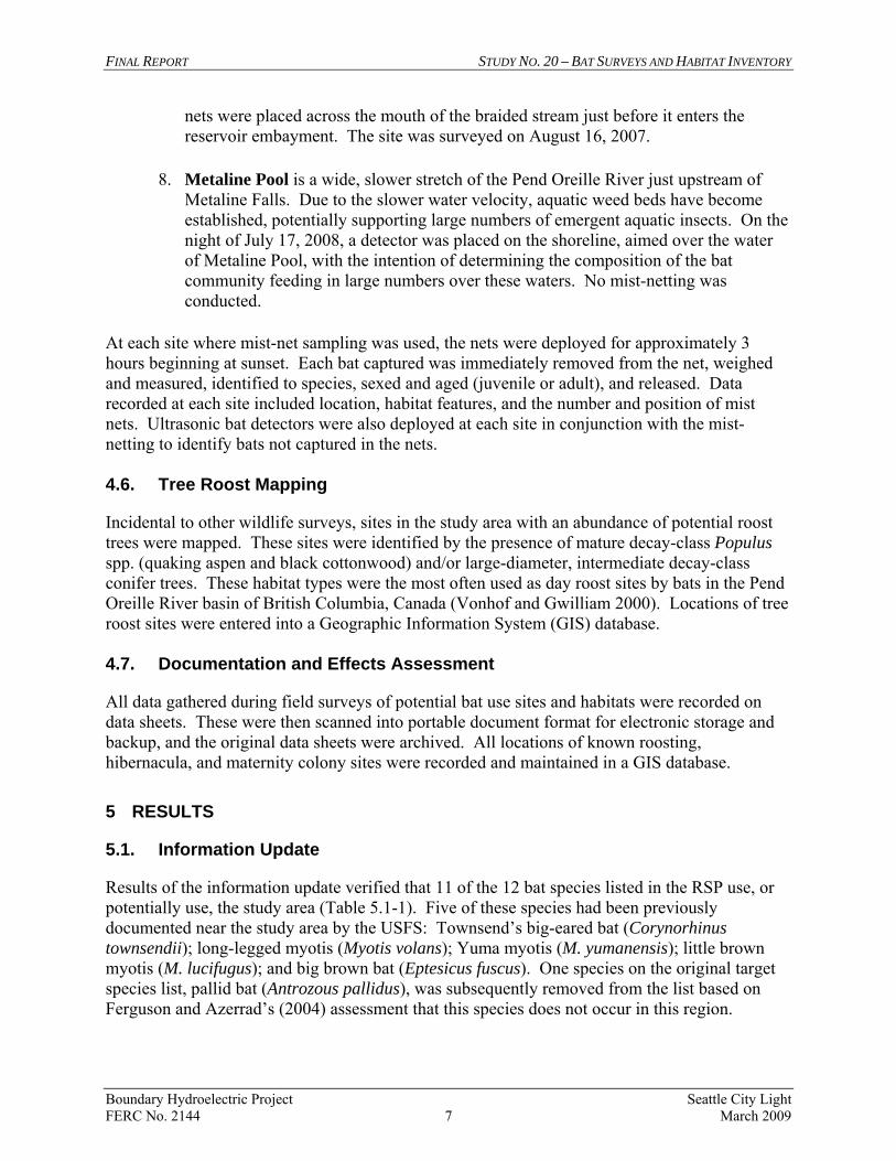
Results of the information update verified that 11 of the 12 bat species listed in the RSP use, or potentially use, the study area (Table 5.1-1). Five of these species had been previously documented near the study area by the USFS: Townsend’s big-eared bat (Corynorhinus townsendii); long-legged myotis (Myotis volans); Yuma myotis (M. yumanensis); little brown myotis (M. lucifugus); and big brown bat (Eptesicus fuscus). One species on the original target species list, pallid bat (Antrozous pallidus), was subsequently removed from the list based on Ferguson and Azerrad’s (2004) assessment that this species does not occur in this region.
FINAL REPORT STUDY NO. 20 – BAT SURVEYS AND HABITAT INVENTORY
Boundary Hydroelectric Project Seattle City Light FERC No. 2144 8 March 2009
The USFS was not able to provide additional information on bat use in the study area beyond the data it supplied for the RSP (Borysewicz 2008) and WDFW has not conducted any bat research in the Project vicinity (Ferguson 2008). Both agencies concurred with the list of bats potentially occurring in the Project area (Table 5.1-1). The BLM provided the results from exit surveys they conducted at Washington Mine on August 22, 2007 (see Section 5.3). Table 5.1-1. Bat species potentially occurring in the study area.
Common Name Scientific Name
USFS Status1
BLM Status2
WDFW Status3 Suitable Habitat
California myotis Myotis californicus
None None None Desert-shrub-oak woodland to ponderosa pine. Roosts in crevices and cracks of canyon walls, caves, and mine shafts.
western small-footed myotis Myotis ciliolabrum
None BT SM Wide ecological range, from rock outcrops on open grasslands to canyons in the foothills to lower mountains with yellow pine woodlands. Day roosts are variable, but include cracks and crevices in cliffs, beneath tree bark, in mines and caves, and human dwellings. Night roosts are under a variety of natural and human-made structures. Hibernacula include caves, mines, and tunnels.
long-eared myotis Myotis evotis
None BT SM Hibernates in caves; summer day roosts under tree bark in coniferous forests.
little brown myotis Myotis lucifugus
None None None Day and night roosts are used by active bats and include, but are not limited to buildings, trees, under rocks, and in wood piles; hibernacula usually include abandoned mines or caves.
fringed myotis Myotis thysanodes
None BT SM Woodlands at moderate elevations in mountains; night and day roosts include caves, mines, and buildings (typically abandoned); hibernacula include caves and buildings.
long-legged myotis Myotis volans
None BT SM Mid-elevation forests; hibernates in winter in mines or caves.
Yuma myotis Myotis yumanensis
None None None Variety of habitats, ranging from juniper and riparian woodlands to desert regions near open water.
hoary bat Lasiurus cinereus
None None None Preference for coniferous versus broadleaf trees.
silver-haired bat Lasionycteris noctivagans
None None None Hardwoods with ponds or streams nearby. Roosts under loose tree bark, particularly willow, maple, and ash, hollow snags, buildings; during winter they hibernate inside trees, buildings, rock crevices, and similarly protected structures.
FINAL REPORT STUDY NO. 20 – BAT SURVEYS AND HABITAT INVENTORY
Table 5.1-1, continued…
Boundary Hydroelectric Project Seattle City Light FERC No. 2144 9 March 2009
Common Name Scientific Name
USFS Status1
BLM Status2
WDFW Status3 Suitable Habitat
big brown bat Eptesicus fuscus
None None None Roosts in tree hollows, natural caves, or openings in rock ledges; some hibernate in caves.
Townsend’s big-eared bat Corynorhinus townsendii
S BA SC Maternity colonies and roosts in caves, mines, and buildings in a variety of habitats.
Notes: 1 U.S. Forest Service (USFS): S = Sensitive 2 Bureau of Land Management (BLM) Status: BA = Bureau Assessment, BT = Bureau Tracking 3 Washington Department of Fish and Wildlife (WDFW) Status: SC = State Candidate for listing as threatened
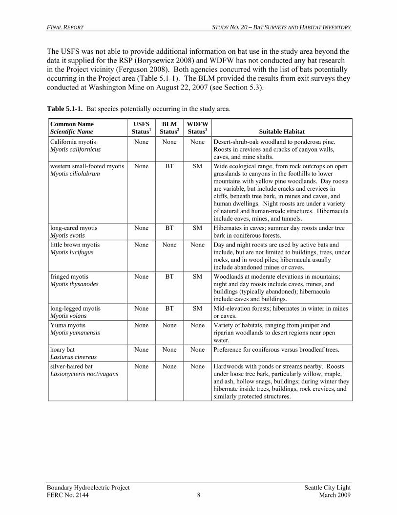
or endangered, SM =State Monitor Source: Nagorsen and Brigham (1993). Table 5.1-2 provides more precise location information (mostly from Boleneus [1999]) for the mines listed in the RSP and indicates whether they occur within the study area. These locations are shown on Figure 5.1-1. The Emerald Mine could not be located (although there is an Emerald Mine located near Salmo, B.C.). Sterling Mine, which has entrances in the study area, was not included in the original table but has been added here. The Thurman site, which is a prospect rather than a past working mine, was located during field surveys and also added to the list. Seven mining-related sites were determined to occur within the study area. Four of the mines (Metaline, Washington, Sterling, and Thurman) were accessible to researchers. The Robert E. Lee Mine is flooded, and evidence of the Hanley Mine is no longer present (it may be underwater). The EPA’s Superfund Technical Assessment and Response Team (E&E 2002) searched for the Z Canyon Mine but could not locate it and concluded that it too was underwater. Three additional mines (Tom Cat, Flusey Group, and Riverside) were investigated to determine their location relative to the study area boundaries. The Tom Cat Mine is apparently located at the top of a ridge west of the dam but could not be located within the study area. The Flusey Group Mine is located on a steep slope on the western side of the Canyon Reach (on SCL property) and includes an adit potentially supporting bats. However, the mine entrance is farther than 200 feet from the reservoir shoreline (outside of the study area). Finally, the Riverside Mine occurs south of Slate Creek on a bench over 250 feet above the river. Part of the mine site occurs within 200 feet of the river, but the shaft, potentially providing habitat for bats, occurs beyond 200 feet and therefore is outside of the study area. Hart Crowser (2006) indicated that an additional adit may occur on the precipice below the site, but neither they nor the Historical Research Associates team (see Study 24 Cultural Resources Study Final Report [SCL 2009a]) were able to locate the alleged adit. Study 20 researchers were also unable to locate the adit during a follow-up survey in July 2008.
FINAL REPORT STUDY NO. 20 – BAT SURVEYS AND HABITAT INVENTORY
Boundary Hydroelectric Project Seattle City Light FERC No. 2144 10 March 2009
Table 5.1-2. Locations of mines in the Project vicinity with potentially suitable bat habitat, determination of occurrence within the study area, and linear distances to the reservoir high-water line (1,994 feet NAVD 88 [1,990 feet NGVD 29]).
Location (UTM)1
Site Name Easting Northing
Within Study Area?
Distance to Reservoir
(ft)2 Comments
Tom Cat 474006 5426338 No >800 Outside of study area. Lakeview 477197 5426324 No 7,550 Outside of study area. Z Canyon 474944 5426032 Yes 445 Not able to locate in field. Hanley 474393 5425877 Yes 15 Flooded; access not possible Giant #1 and #2 474135 5422514 No 3,795 Outside of study area. Hoage 474008 5421880 No 4,525 Outside of study area. Lead King 474097 5420613 No 4,150 Outside of study area. Flusey Group 475546 5420351 No 25 Outside of study area. Lucky Strike #1 and #2 475764 5419783 No 1,040 Outside of study area. Robert E. Lee 475036 5419263 Yes 10 Flooded; access not possible Riverside 475559 5418460 No 350 Could not locate adit; water well
outside the study area. Yellowhead 472830 5414549 No 740 Outside of study area. Pend Oreille 473606 5414367 No 1,160 Outside of study area. Sullivan 472526 5414028 No 925 Outside of study area. Grandview 473802 5413376 No 1,575 Outside of study area. Washington 472691 5412606 Yes 25 Roost, hibernaculum, and maternal
colony surveys performed. Oriole 469715 5411997 No 6,360 Outside of study area. Blue Bucket 470783 5410168 No 1,785 Outside of study area. Metaline 471385 5410009 Yes 60 Roost, hibernaculum, and maternal
colony surveys performed Wolf Creek 472007 5408439 No 980 Outside of study area. Thurman 47223 5410504 Yes 50 A prospect, not a mine. Not included
on the list in the RSP. Roost and hibernaculum surveys performed.
Emerald N/A N/A N/A N/A Could not be located. Sterling 471278 5409321 Yes <200 Roost survey performed.
Notes: 1 Boleneus (1999). 2 Distance from adit to reservoir high water line. RSP – Revised Study Plan UTM – Universal Transverse Mercator
LimeLake
LedbetterLake
Lower LeadKing Lake
Upper LeadKing Lake
CrescentLake
Slate
Creek
Pend
Oreil
le
River
Flume
C reek
Uncas
Gulch
Threemile
Creek
South Fork Flume
Creek
Pewe
e
CreekFence Creek
Sl umb
e r
Creek
Lime
Creek
Middle
Fork Flume Creek
Everett
Creek
North
Fork
Sullivan
Creek
Be aver
Creek
31
C2975
CANADA
UNITED STATES
BoundaryDam
PeweeFalls
Riverside
Z Canyon
Yellowhead
Tom Cat
Sullivan
Robert E. Lee
Pend Oreille
Lucky Strike
Lead King
Lakeview
Hoage
Hanley
Grandview
Giant
Flusey Group
SEATTLE CITY LIGHTBOUNDARY HYDROELECTRIC PROJECT
FERC PROJECT NO. 2144
Figure 5.1-1Locations of mines within and
nearby the study area.
0 0.5
Miles
Unpublished Work Copyright 2008 Seattle City Light
(Map 1 of 2)
LegendMine LocationsRoadsStreamsWaterbodiesStudy Area BoundaryExisting Project Boundary
MapKey
Map Version 08/20/08
LostLake
WolfLake
LimeLake
Pend
Ore
il le
Riv
er
Flume
C reek
Threemile
Creek
South Fork Flume
Creek
Sullivan
CreekSand
Cre
ek
Sweet
Cre ek
Lunch
Creek
Pocahontas Creek
Linton
Creek
Lost
Cree k
Wolf
Creek
BoxCanyon
Dam
31
Metaline
MetalineFalls
C9345
Yellowhead
Washington
Wolf Creek
Sullivan
Sterling
Pend Oreille
Oriole
Metaline
Grandview
Blue Bucket
Thurman Adit
SEATTLE CITY LIGHTBOUNDARY HYDROELECTRIC PROJECT
FERC PROJECT NO. 2144
Figure 5.1-1Locations of mines within and
nearby the study area.
0 0.5
Miles
Unpublished Work Copyright 2008 Seattle City Light
(Map 2 of 2)
LegendMine Locations
Roads
Streams
Waterbodies
Study Area Boundary
Existing Project Boundary
MapKey
Map Version 09/29/08
FINAL REPORT STUDY NO. 20 – BAT SURVEYS AND HABITAT INVENTORY
Boundary Hydroelectric Project Seattle City Light FERC No. 2144 13 March 2009
5.2. Inventory and Characterization of Bat Habitats
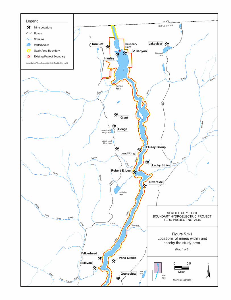
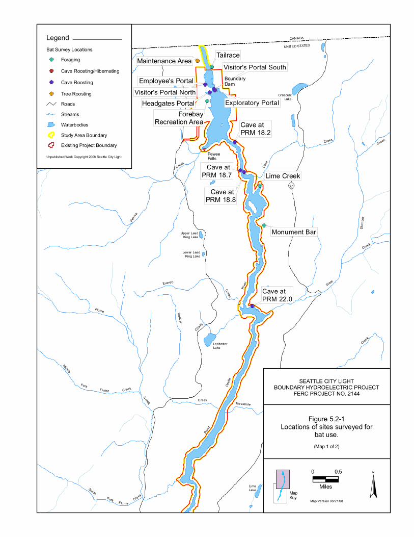
Sites identified in the field as potential day roosts, maternal roosts, or hibernacula are identified in Figure 5.2-1 and include mine adits, mine prospects (shallow exploratory adits), caves, tunnels and portals associated with Boundary Dam, SCL maintenance buildings, and the tree roost sites (discussed in Section 5.6). Bats use a variety of sites as day roosts, including all of the structures mentioned above. However, maternal roosts must have specific characteristics to facilitate the protection and growth of natal bats. In general, bat species potentially breeding in the study area use maternity sites that are humid and warm. Myotis spp. (myotis), for example, can tolerate maximum daily temperatures from 30 to 40°C (86 to 104°F) (Nagorsen and Brigham 1993; Williams and Brittingham 1997), whereas 18 to 30°C (64 to 86°F) is more typical for Townsend’s big-eared bat maternal roosts (Pierson and Rainey 1998). Bats will develop maternal colonies in structures with lower temperatures but there must be enough individuals to raise the temperature by clustering (in numbers from 30 to the hundreds), thereby using their combined body heat to increase the temperature and maintain a warmer microclimate (Betts 1997). In contrast, suitable hibernacula are humid structures that maintain temperatures near 0°C (Fenton and Barclay 1980). Temperatures below freezing can kill some hibernating bats, and temperatures much higher than freezing will wake bats from torpor resulting in depletion of energy reserves, possibly leading to starvation (Humphries et al. 2003). Relative humidity of greater than 85 percent is apparently necessary to help hibernating myotis prevent water loss (Fenton and Barclay 1980; Fenton 1983; Bilecki 2003). Townsend’s big-eared bats are seemingly more tolerant of temperatures near freezing and of lower levels of humidity (Raesly and Gates 1987; Clark et al. 1996; Jagnow 1998). The following features in the study area were investigated to assess their potential to serve as day roosts, maternity roosts, or hibernacula.
• Mine Adits—Field investigations revealed that four of the seven mine adits within the study area (Metaline, Washington, Sterling, and Thurman) provide day roosting habitat for bats (Figure 5.2-1). Metaline and Washington mines are extensive enough that they could possibly provide hibernating habitat for bats as well, but are probably too cold for use by maternal bats. June temperatures recorded at the adit entrances were less than 20°C (68°F), with the likelihood of much colder summer temperatures deeper in the mine. October humidity recordings at the entrances of both mines were less than 75 percent, but that value may not represent the relative humidity at microsites within the mine that might support hibernating bats. Running water is also found in both the Metaline and Washington mines, providing a humidity source. The Sterling Mine location includes two adits. The northern adit is about 6 feet tall, 10 feet wide, and extends back about 40 feet. It is very open and exposed, tapering to a small space in the back. It does not have the depth or size to provide suitable habitat for maternal or hibernating bats. The southern adit is quite different. The
FINAL REPORT STUDY NO. 20 – BAT SURVEYS AND HABITAT INVENTORY
Boundary Hydroelectric Project Seattle City Light FERC No. 2144 14 March 2009
opening measures about 2 feet by 4 feet, then drops into an adit of about 8 feet by 8 feet that extends into the hillside farther than could be determined with flashlights. It is possible that the mine, similar to the Metaline and Sterling mines, could serve as a hibernaculum. Thurman adit is an exploratory prospect extending only about 30 feet into the hillside with a small, partially collapsed entrance. Although it provides suitable day roosting habitat, it is probably too small to maintain winter temperatures above freezing and too enclosed to allow enough warm summer air inside to heat the interior to suitable temperatures for maternal colonies. The summer temperature recorded at the adit entrance was only 16°C (60°F). An additional (unnamed) exploratory adit was located near Slate Creek several hundred vertical feet above the reservoir, but was deemed too shallow (approximately 10 feet) and smooth-walled (no crevices) to support roosting bats.
• Shoreline Caves—A number of variously-sized natural caves occur along the reservoir downstream of Metaline Falls; only two of these features in the study area showed evidence of day roost use by bats. The dry cave at PRM 18.7 is located on the river canyon west bank, approximately 1.5 miles upstream of the Boundary forebay. This is a large natural cave with an opening approximately 20 feet high by 15 feet wide, and a depth of about 30 feet. A Townsend’s big-eared bat was seen roosting in the cave during the daytime on four different occasions between late March and mid-May 2008, and two big-eared bats were observed roosting in the cave on September 16, 2008. Also, several species of bats were detected flying around the cave entrance during acoustical surveys. Another much smaller cave is located less than a half mile downstream of the mouth of Slate Creek at PRM 22.0. The entrance is about 5 feet by 5 feet, and the cave forms a pocket with a depth of about 10 feet. Its value to bats appears limited, although the carcass of an unknown myotis was found inside and there are a number of small crevices. Neither of the two caves potentially used as day roosts is large enough to serve as hibernacula and no evidence of maternal bat use was recorded during spring and summer surveys. A small, natural cave was also located several hundred vertical feet above the reservoir pool near Slate Creek (near an adit described in Section 5.1), but it is too shallow to support roosting bats. Finally, the USFS list in the table provided in the RSP included a cave described as “Unknown Cave above Lime Creek.” An extensive search in the study area failed to locate this cave.
• Partially Submerged Caves—Two additional caves in the Canyon Reach have entrances that that will completely submerge; however, even at the full pool elevation, at least 10 vertical feet of open space ceiling remains inside the caves. Three unidentified myotis were found roosting on the ceiling of the downstream cave (PRM 18.2) during daylight hours on two occasions. No bats were observed at the second cave at PRM 18.8 (however, an intact barn swallow nest was found). The small size of these caves makes them unsuitable as maternal sites or hibernacula.
LimeLake
LedbetterLake
Lower LeadKing Lake
Upper LeadKing Lake
CrescentLake
Slate
Creek
Pend
Oreil
le
River
Flume
C reek
Uncas
Gulch
Threemile
Creek
South Fork Flume
Creek
Pewe
e
CreekFence Creek
Sl umb
e r
Creek
Lime
Creek
Middle
Fork Flume Creek
Everett
Creek
North
Fork
Sullivan
Creek
Be aver
Creek
31
C2975
CANADA
UNITED STATES
Cave at PRM 18.7
Visitor's Portal North
Tailrace
Monument Bar
Lime Creek
Headgates Portal Exploratory Portal
Employee's Portal
Cave at PRM 22.0
Visitor's Portal South
ForebayRecreation Area
Maintenance Area
Cave at PRM 18.8
Cave at PRM 18.2
BoundaryDam
PeweeFalls
SEATTLE CITY LIGHTBOUNDARY HYDROELECTRIC PROJECT
FERC PROJECT NO. 2144
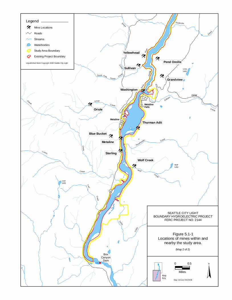
Figure 5.2-1Locations of sites surveyed for
bat use.
0 0.5
Miles
Unpublished Work Copyright 2008 Seattle City Light
(Map 1 of 2)
LegendBat Survey Locations
ForagingCave Roosting/HibernatingCave RoostingTree RoostingRoadsStreamsWaterbodiesStudy Area BoundaryExisting Project Boundary
MapKey
Map Version 08/21/08
LostLake
WolfLake
LimeLake
Pend
O reil
le Ri
ver
Flume
C reek
Threemile
Creek
South Fork Flume Creek
North
Fork
Sullivan
Creek
Sullivan
CreekSand
Cree
k
Sweet
C re ekLunch
Creek
Pocahontas Creek
Linton Creek
Lost
C ree k
Wolf Creek
31
Metaline
MetalineFalls
C9345
MetalineMine
Washington Mine
Thurman Adit
Sullivan CreekRiparian
Boundary Wildlife Preserve
Box CanyonRiparian
Sullivan CreekCottonwoods
Metaline Pool
SterlingMine
BoxCanyon
Dam
SEATTLE CITY LIGHTBOUNDARY HYDROELECTRIC PROJECT
FERC PROJECT NO. 2144
Figure 5.2-1Locations of sites surveyed for
bat use.
0 0.5
Miles
Unpublished Work Copyright 2008 Seattle City Light
(Map 2 of 2)
LegendBat Survey Locations
ForagingCave Roosting/HibernatingCave RoostingTree RoostingRoadsStreamsWaterbodiesStudy Area BoundaryExisting Project Boundary
MapKey
Map Version 08/21/08
FINAL REPORT STUDY NO. 20 – BAT SURVEYS AND HABITAT INVENTORY
Boundary Hydroelectric Project Seattle City Light FERC No. 2144 17 March 2009
• Dam Portals and Tunnels—Five portals associated with Boundary Dam (Figure
5.2-1) may provide limited habitat for bats. These include the north and south portals of the visitor’s tunnel, the employee’s portal (with an offshoot adit to the mucking room), the headgate portal, and the exploratory portal. (For purposes of this discussion, a “portal” is defined as an opening into the rock; several large openings of this nature were created in association with construction of the Project. A “tunnel” is a continuous opening that is entered/exited at each end through a portal.) Based on the high level of human and equipment activity and the relatively smooth rock substrate, the employee’s portal appeared to be the least likely portal/tunnel to support bats. However, the mucking room fork of the employee’s portal is relatively dark with a lesser amount of human activity and therefore appeared to offer better conditions for roosting bats. The visitor’s tunnel provides some crevices for roosting bats near the north portal entrance, but most of its length at the southern opening has been smoothed with concrete or covered with tile and other materials; therefore, it is not adequate for roosting. The headgate portal is similar to the visitor’s tunnel, but there are fewer crevices. The exploratory portal is a narrow shaft extending only about 20 feet into the solid rock, is smooth-walled, and does not appear to provide more than marginal roosting habitat. Although the few crevices and recesses found in these features may provide some opportunity for roosting bats, none are large enough for establishing maternal colonies, and the interiors are relatively cooler (20°C) and lower in humidity (<70 percent) than those preferred by maternal bats. Human activity and warm temperatures would preclude use of the portals and tunnels as hibernacula.
• Buildings—Six maintenance facility buildings, located below Boundary Dam (Figure
5.2-1), were examined for potential bat use. Only the large shop building appeared to be accessible to bats, but no evidence of bat use was found there or at any of the other facilities. Ross Cabin, an old miner’s log cabin in the Forebay Recreation Area, could potentially support roosting bats and is discussed further in Section 5.5.
• Mine Adits and Caves Below the Normal High Water Surface Elevation—A
survey during the September 6, 2007, drawdown (as measured at the Boundary Dam forebay), when the reservoir was held at or below elevation 1,970 feet NAVD 88 (1,966 feet NGVD 29) identified five caves and four mine adits in the area between 1,974- to 1,994-feet NAVD 88 (1,970- to 1,990-feet NGVD 29). Two of the caves (discussed above) are partially open during normal Project operations and provide dry roosting habitat for bats. The remaining seven structures are completely inundated during normal Project operations. All of these structures were shallow (6 to 25 feet deep), and may once have provided limited day roost habitat for bats. None of the structures had the characteristics suitable for maternal or hibernation use if the reservoir were operated at lower water surface elevations. As stated in the RSP, Task 2 for Study 20, (SCL 2007), Project maintenance very infrequently requires that the Boundary Project forebay be drawn down below elevation 1,974 feet NAVD 88 (1,970 feet NGVD 29) to elevation 1,954 feet NAVD
FINAL REPORT STUDY NO. 20 – BAT SURVEYS AND HABITAT INVENTORY
Boundary Hydroelectric Project Seattle City Light FERC No. 2144 18 March 2009
88 (1,950 feet NGVD 29). Between 1987 and 2005 (the period represented by the Project hydrologic record (R2 Resource Consultants, Inc. 2008), drawdowns below 1,974 feet NAVD 88 (1,970 feet NGVD 29) occurred less than 0.25 percent of the time (equivalent to 17.5 days) and drawdowns at or below 1,964 feet NAVD (1,960 feet NGVD) occurred only 0.02 percent of the time (equivalent to 1.5 days); the lowest recorded forebay elevation within the 19-year hydrologic record was 1,957 feet NAVD 88 (1,953 feet NGVD 29). The examination of re-construction photographs (SCL 1966) of the lower reservoir indicated that there are numerous caves and at least two mine adits at elevations well below 1,954 feet NAVD 88 (1,950 feet NGVD 29). Only two caves were identified that appeared to be within the 20 foot zone between 1,954 feet and 1,974 feet NAVD 88 (1,950 and 1,970 feet NGVD 29); they are located adjacent to each other on a rock face at the lower end of the Canyon Reach. One cave is approximately 15 by 6 by 10 feet, and because of its shallow depth, probably provided little habitat value to bats. The dimensions of the other cave were approximately 75 by 15 by 50 feet end not visible (ENV). The exact depth of this cave cannot be determined, however, it is likely that it once provided roosting habitat for bats; it is less clear whether it may have provided for maternal or hibernation use.
The pre-construction photographs revealed that there were numerous crevices associated with shears, fault lines, and loose rock that likely provided summer roosting habitat for solitary or small groups of bats (especially myotis). However, the highest quality structures in the study area for supporting large numbers of bats (e.g., Sterling, Metaline, and Washington mines) are currently available for use. Although appropriately-scaled pre-construction photographs were not available for the upper reservoir, all potential locations where caves or mines could have occurred within the fluctuation zone were surveyed during the September 6, 2007, drawdown. No caves or mine adits were observed.
5.3. Roost Site and Maternity Colony Surveys
Summer surveys in 2007 and 2008 were conducted at 10 locations to assess bat roosting and maternal colony use. As determined by the habitat inventory and characterization task (Section 5.2), most of the sites appeared capable of providing day roosting habitat. None, however, appeared particularly suitable for use by maternal bats due to either cool or unmoderated temperatures. Nonetheless, bats are capable of increasing and maintaining microclimate temperatures by combining body heat in the form of clustering (Betts 1997), so the potential use of study area structures with cooler temperatures could not be completely eliminated from further consideration. Although the best means of identifying maternal roosts is to enter the sites, the deeper mine adits were not entered due to safety concerns. An alternative method to document maternal bat use of a structure is to monitor for large numbers of bats (greater than 30) exiting the structure during the early evening. If large numbers were observed, follow-up mist net surveys for lactating females could confirm maternal use. The summer survey results from each of the 10 locations follow.
FINAL REPORT STUDY NO. 20 – BAT SURVEYS AND HABITAT INVENTORY
Boundary Hydroelectric Project Seattle City Light FERC No. 2144 19 March 2009
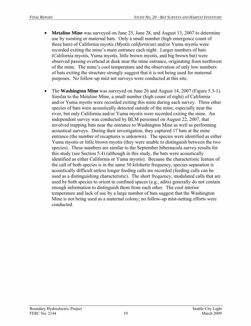
• Metaline Mine was surveyed on June 25, June 28, and August 13, 2007 to determine use by roosting or maternal bats. Only a small number (high emergence count of three bats) of California myotis (Myotis californicus) and/or Yuma myotis were recorded exiting the mine’s main entrance each night. Larger numbers of bats (California myotis, Yuma myotis, little brown myotis, and big brown bat) were observed passing overhead at dusk near the mine entrance, originating from northwest of the mine. The mine’s cool temperature and the observation of only low numbers of bats exiting the structure strongly suggest that it is not being used for maternal purposes. No follow-up mist net surveys were conducted at this site.
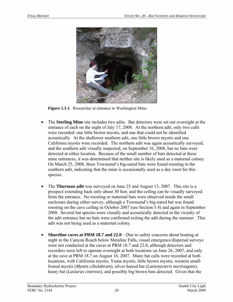
• The Washington Mine was surveyed on June 26 and August 14, 2007 (Figure 5.3-1).
Similar to the Metaline Mine, a small number (high count of eight) of California and/or Yuma myotis were recorded exiting this mine during each survey. Three other species of bats were acoustically detected outside of the mine, especially near the river, but only California and/or Yuma myotis were recorded exiting the mine. An independent survey was conducted by BLM personnel on August 22, 2007, that involved trapping bats near the entrance to Washington Mine as well as performing acoustical surveys. During their investigation, they captured 17 bats at the mine entrance (the number of recaptures is unknown). The species were identified as either Yuma myotis or little brown myotis (they were unable to distinguish between the two species). These numbers are similar to the September hibernacula survey results for this study (see Section 5.4) (although in this study, the bats were acoustically identified as either California or Yuma myotis). Because the characteristic feature of the call of both species is in the same 50 kilohertz frequency, species separation is acoustically difficult unless longer feeding calls are recorded (feeding calls can be used as a distinguishing characteristic). The short frequency, modulated calls that are used by both species to orient in confined spaces (e.g., adits) generally do not contain enough information to distinguish them from each other. The cool interior temperature and lack of use by a large number of bats suggest that the Washington Mine is not being used as a maternal colony; no follow-up mist-netting efforts were conducted.
FINAL REPORT STUDY NO. 20 – BAT SURVEYS AND HABITAT INVENTORY
Boundary Hydroelectric Project Seattle City Light FERC No. 2144 20 March 2009
Figure 5.3-1. Researcher at entrance to Washington Mine.
• The Sterling Mine site includes two adits. Bat detectors were set out overnight at the
entrance of each on the night of July 17, 2008. At the northern adit, only two calls were recorded: one little brown myotis, and one that could not be identified acoustically. At the shallower southern adit, one little brown myotis and one California myotis were recorded. The northern adit was again acoustically surveyed, and the southern adit visually inspected, on September 16, 2008, but no bats were detected at either location. Because of the small number of bats detected at these mine entrances, it was determined that neither site is likely used as a maternal colony. On March 25, 2008, three Townsend’s big-eared bats were found roosting in the southern adit, indicating that the mine is occasionally used as a day roost for this species.
• The Thurman adit was surveyed on June 25 and August 13, 2007. This site is a
prospect extending back only about 30 feet, and the ceiling can be visually surveyed from the entrance. No roosting or maternal bats were observed inside the small enclosure during either survey, although a Townsend’s big-eared bat was found roosting on the cave ceiling in October 2007 (see Section 5.4) and again in September 2008. Several bat species were visually and acoustically detected in the vicinity of the adit entrance but no bats were confirmed exiting the adit during the summer. This adit was not being used as a maternal colony.
• Shoreline caves at PRM 18.7 and 22.0—Due to safety concerns about boating at
night in the Canyon Reach below Metaline Falls, visual emergence/dispersal surveys were not conducted at the caves at PRM 18.7 and 22.0, although detectors and recorders were left to operate overnight at both locations on June 26, 2007, and only at the cave at PRM 18.7 on August 16, 2007. Many bat calls were recorded at both locations, with California myotis, Yuma myotis, little brown myotis, western small-footed myotis (Myotis ciliolabrum), silver-haired bat (Lasionycteris noctivagans), hoary bat (Lasiurus cinereus), and possibly big brown bats detected. Given that the
FINAL REPORT STUDY NO. 20 – BAT SURVEYS AND HABITAT INVENTORY
Boundary Hydroelectric Project Seattle City Light FERC No. 2144 21 March 2009
acoustical detectors can detect bats over 100 feet away, that the cave entrances are immediately adjacent to reservoir foraging habitat, that many of the bats detected are not cave-dwellers, and that no bats were visually recorded inside these caves, it is unlikely that the few bats acoustically recorded were actually using the caves. Although both caves are occasionally used as day roosting sites (a dried bat carcass was found in the cave at PRM 22.0, and Townsend’s big-eared bats were recorded in the cave at PRM 18.7), neither cave is very large and both are unlikely to support maternal bat use. No bats were observed in the caves during daylight surveys prior to detector placement, suggesting that any roosting occurring in these structures is concealed within crevices or intermittent.
• Dam Portals and Tunnels—A bat survey of the underground structures associated
with Boundary Dam and powerhouse was conducted on June 17, 2007. No roosting bats or guano were observed, and only a few features suggesting potential use, such as crevices, were noted. Still, given that these features represent potential (albeit marginal) bat habitat, additional survey work was conducted. The north portal of the visitor’s tunnel and employee’s portal were visually and acoustically surveyed for exiting bats, whereas the south portal of the visitor’s tunnel, the headgate portal, and the exploratory portal were only acoustically surveyed. The exit surveys at the north portal of the visitor’s tunnel and the employee’s portal were conducted on June 27, 2007. No bats were observed emerging from the employee’s portal, whereas four bats emerged from the visitor’s tunnel north portal. The bats were visually identified as Myotis spp. and acoustically identified as little brown myotis. Silver-haired bats were acoustically detected several times at the entrance to the visitor’s tunnel north portal, but it is believed that these bats were not entering the portal, but rather feeding around the nearby lights. No bat calls were acoustically detected at the visitor’s tunnel south portal, the headgate portal, or the exploratory portal during the June 27th survey.
Follow-up acoustical surveys were performed at the visitor’s north portal and employee’s portal on July 16, 2008. Detectors were left overnight inside the north visitor’s portal, the employee’s tunnel at the mucking tunnel fork, and inside the mucking tunnel. Only one call was recorded: a little brown myotis at the employee’s tunnel-mucking tunnel fork. It was concluded that only a few little brown myotis were day roosting in the portals and tunnel associated with Boundary Dam, and none of this was maternal use. Too few bats were observed to warrant a follow-up mist net survey.
Although the observed level of bat use of potentially suitable roost sites in the study area was low and no evidence of maternity use was found, large numbers of bats were regularly observed foraging over the reservoir between Metaline Falls and the Metaline Mine (see Section 5.5). This area also receives relatively high use by swallows, piscivorous waterbirds, and waterfowl, suggesting a rich ecology driven, perhaps, by the presence of emergent aquatic insects.
FINAL REPORT STUDY NO. 20 – BAT SURVEYS AND HABITAT INVENTORY
Boundary Hydroelectric Project Seattle City Light FERC No. 2144 22 March 2009
5.4. Hibernacula Surveys
The Metaline and Washington mines are likely the only features in the study area that represent potential hibernacula. The exploratory portal at Boundary Dam, the caves along the reservoir, and the Thurman adit are too shallow and/or too exposed to maintain temperatures above freezing during the winter (bats generally hibernate in mines or caves at depths of several hundred feet where freezing temperatures cannot penetrate). Although the portals and tunnels associated with Boundary Dam would remain above freezing during the winter, constant human activities associated with these structures, coupled with marginal habitat features, likely inhibit use by hibernating bats. The Metaline and Washington mines were surveyed in September and October 2007 for the presence of swarming bats, which is indicative of use as winter hibernacula. Similar to the results of the roost site and maternity colony surveys, only small numbers of California and/or Yuma myotis were observed using the two mines (a high count of 5 bats for the Metaline Mine and 14 for the Washington Mine). During the October 11, 2007, exit survey, one larger bat was visually observed flying very near the Washington Mine entrance; this bat triggered the acoustical detector and was later acoustically identified as a Townsend’s big-eared bat. The Townsend’s big-eared bat was not observed using the Washington Mine at any point. The Thurman adit also was surveyed in September and October 2007. During the October 12, 2007, survey, a single Townsend’s big-eared bat was noted day roosting near the entrance. While recording the bat, a better view of the adit interior was afforded, revealing a shallow (30 feet deep) prospect instead of a mine. The Thurman adit was subsequently removed from consideration as a potential hibernaculum because of its small size. In conclusion, small numbers of myotis appear to be using Metaline and Washington mines as day roosts, and possibly as hibernacula, but the latter cannot be confirmed without a winter interior inspection of each mine. However, given that only a small number of bats were recorded using these mines in the fall of 2007, there was not sufficient cause to warrant conducting winter surveys of the Metaline or Washington mines. 5.5. Foraging Site Sampling
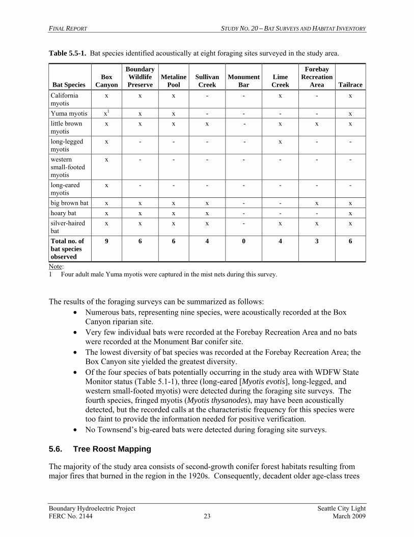
Foraging surveys were conducted at eight sites in July and August 2007 and July 2008 (acoustic survey only), as shown on Figure 5.2-1. Bats were detected at all sites except in the conifer habitats at Monument Bar (Table 5.5-1). Four adult male Yuma myotis were captured at the Box Canyon riparian site on October 17, 2007, and represent the only successful mist net captures during the course of the foraging site sampling (most bats appeared to detect the mist nets and actively avoided them). Consequently, the acoustical data provided much more information on bat use than the mist net data.
FINAL REPORT STUDY NO. 20 – BAT SURVEYS AND HABITAT INVENTORY
Boundary Hydroelectric Project Seattle City Light FERC No. 2144 23 March 2009
Table 5.5-1. Bat species identified acoustically at eight foraging sites surveyed in the study area.
Bat Species Box
Canyon
Boundary Wildlife Preserve
Metaline Pool
Sullivan Creek
Monument Bar
Lime Creek
Forebay Recreation
Area TailraceCalifornia myotis
x x x - - x - x
Yuma myotis x1 x x - - - - x little brown myotis
x x x x - x x x
long-legged myotis
x - - - - x - -
western small-footed myotis
x - - - - - - -
long-eared myotis
x - - - - - - -
big brown bat x x x x - - x x hoary bat x x x x - - - x silver-haired bat
x x x x - x x x
Total no. of bat species observed
9 6 6 4 0 4 3 6
Note: 1 Four adult male Yuma myotis were captured in the mist nets during this survey. The results of the foraging surveys can be summarized as follows:
• Numerous bats, representing nine species, were acoustically recorded at the Box Canyon riparian site.
• Very few individual bats were recorded at the Forebay Recreation Area and no bats were recorded at the Monument Bar conifer site.
• The lowest diversity of bat species was recorded at the Forebay Recreation Area; the Box Canyon site yielded the greatest diversity.
• Of the four species of bats potentially occurring in the study area with WDFW State Monitor status (Table 5.1-1), three (long-eared [Myotis evotis], long-legged, and western small-footed myotis) were detected during the foraging site surveys. The fourth species, fringed myotis (Myotis thysanodes), may have been acoustically detected, but the recorded calls at the characteristic frequency for this species were too faint to provide the information needed for positive verification.
• No Townsend’s big-eared bats were detected during foraging site surveys. 5.6. Tree Roost Mapping
The majority of the study area consists of second-growth conifer forest habitats resulting from major fires that burned in the region in the 1920s. Consequently, decadent older age-class trees
FINAL REPORT STUDY NO. 20 – BAT SURVEYS AND HABITAT INVENTORY
Boundary Hydroelectric Project Seattle City Light FERC No. 2144 24 March 2009
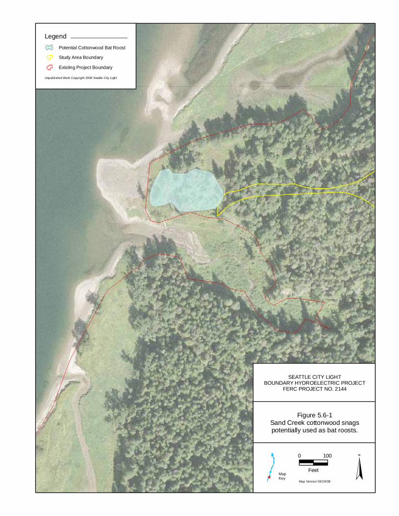
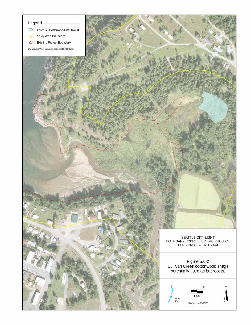
and large snags are not abundant. Apart from the occasional pine snag excavated by pileated woodpeckers (Dryocopus pileatus) or northern flickers (Colaptes auratus), limited cavity habitat for tree-roosting bats was recorded in the conifer forests in the study area. Potential deciduous tree-roosting habitat does occur at the BWP (Figure 5.6-1) and along Sullivan Creek (Figure 5.6-2). The BWP supports extensive stands of cottonwood, aspen, and other deciduous trees that provide potential roosting habitat, and probably most closely represent the habitat types found to be used by roosting bats in the Pend Oreille River Valley of British Columbia (Vonhof and Gwilliam 2000). The only concentration of large cottonwood snags in the study area with abundant cavities for roosting bats is located on the BWP at the mouth of Sand Creek. While more limited than the BWP, the cottonwood stands at Sullivan Creek also offer potential tree-roosting habitat for bats, especially the patch of large cottonwood snags found ringing the eastern shoreline of the upper pond.
SEATTLE CITY LIGHTBOUNDARY HYDROELECTRIC PROJECT
FERC PROJECT NO. 2144
Figure 5.6-1Sand Creek cottonwood snagspotentially used as bat roosts.
Map Version 09/29/08
0 100
Feet
Unpublished Work Copyright 2008 Seattle City Light
LegendPotential Cottonwood Bat Roost
Study Area Boundary
Existing Project Boundary
MapKey
SEATTLE CITY LIGHTBOUNDARY HYDROELECTRIC PROJECT
FERC PROJECT NO. 2144
Figure 5.6-2Sullivan Creek cottonwood snags
potentially used as bat roosts.
Map Version 09/29/08
0 100
Feet
Unpublished Work Copyright 2008 Seattle City Light
LegendPotential Cottonwood Bat Roost
Study Area Boundary
Existing Project Boundary
MapKey
FINAL REPORT STUDY NO. 20 – BAT SURVEYS AND HABITAT INVENTORY
Boundary Hydroelectric Project Seattle City Light FERC No. 2144 27 March 2009
5.7. Effects Assessment
With two exceptions, none of the caves or mines used or potentially used by bats in the study area are hydrologically connected to the reservoir and, therefore, water surface elevations have no influence on bat use of these sites. One of the exceptions is a natural cave located near the mouth of the Canyon Reach at PRM 18.2 that is partially submerged. The entrance of this cave is closed by high water during peak water surface elevations in the course of daily reservoir fluctuations; however, approximately 10 feet of dry space remains inside the cave even during the highest pool levels, and as many as three bats (myotis) have been recorded roosting in the cave. In general, this cave is closed 3–14 percent of the time annually (on average about 4 hours per day), and always during the morning hours. The cave is never closed during the evening hours when bats are active. The second exception is a cave located at PRM 18.8 in the Canyon Reach. Like the cave at PRM 18.2, it is partially submerged during peak water surface elevations with approximately 10 feet of dry space inside the cave during the highest pool levels. Unlike the other cave, no bats were ever found roosting in this cave’s dry ceiling. Several mine adits and caves in the lower reservoir exposed during the September 2007 drawdown could potentially provide bat roosting habitat if the reservoir were operated at lower pool levels. However, nearly all of these sites were shallow or silted in and none would be expected to serve as more than an occasional roost site. Structures associated with Boundary Dam receive only a minor amount of bat use (no more than four individual bats were detected at the employee’s portal and visitor’s tunnel, and the maintenance buildings north of the dam do not represent high quality bat habitat). The two stands of trees that represent the best tree roosting habitat in the study area (at Sullivan Creek and the BWP) are well above the fluctuation zone and are not affected by changing reservoir water surface elevations. Bats native to Washington forage on a variety of flying insects, including the adult phases of many aquatic macroinvertebrates such as midges [Chironomidae and Ceratopogoninae], caddisflies [Cheumatopsyche], and mayflies [Ephemerella excrusian]). Results from a May 2007 survey conducted in the upper reservoir for the Benthic Macroinvertebrate Habitat Suitability Index study (Appendix 8 in Study 7, Mainstem Aquatic Habitat Modeling Study Final Report [SCL 2009b]) found that macroinvertebrate composition and density varies by substrate and depth. At sites composed of hard substrates (generally cobble), macroinvertebrate biomass was very low in the 2-foot-depth interval, higher in the 5-foot interval, and much higher in the 10-20 foot interval. At soft substrate (mud) sites, there was a high biomass of worms (Oligocheata) in the 2-foot-depth interval, but no macroinvertebrate species important to bats (SCL 2009b). The 10- and 15-foot depths had modest amounts of macroinvertebrate biomass, including midges. Fluctuating water surface levels at Boundary Reservoir appear to prevent or limit the production of midges, caddisflies, and mayflies in both rocky and mud substrates in areas that have very shallow water (< 2 feet) and are subject to daily desiccation. The deeper portions of the fluctuation zone, however, support a moderate to high biomass of macroinvertebrates that represent bat prey. Macroinvertebrate production from these deeper zones apparently provides prey in quantities sufficient to attract the high numbers of bats observed foraging over the
FINAL REPORT STUDY NO. 20 – BAT SURVEYS AND HABITAT INVENTORY
Boundary Hydroelectric Project Seattle City Light FERC No. 2144 28 March 2009
reservoir upstream of Metaline Falls in the summers of 2007 and 2008. Although project operations may be influencing aquatic macroinvertebrate production in some areas of the reservoir, it does not appear to have a significant effect on the prey base for bats. No non-Project activities were identified as potentially affecting bats. Incidental observations during the terrestrial studies suggest that both Metaline and Washington mines are regularly visited by humans, but the potential effect on bats is unknown. Further, the BLM intends to gate the Washington Mine in 2009 (Lowe 2008) to ensure disturbance to bats is minimized.
6 CONCLUSIONS
Surveys were conducted for the presence of bats and bat habitat within the study area. Key results include the following:
• Of the 11 bat species with ranges that include northeastern Washington, 10 were documented in the study area.
• Small numbers of bats (mostly California and/or Yuma myotis) roost within the Metaline and Washington mines; there is no evidence that these mines are used as maternity colonies or hibernacula.
• No bats were captured and a relatively small number of bats were acoustically recorded at the Boundary tailrace, the SCL Boundary Forebay Recreation Area, Lime Creek, Sullivan Creek, and the BWP riparian sites; at the Monument Bar conifer site, no bats were detected at all.
• High numbers and a high diversity of bats were recorded acoustically at the Box Canyon riparian site (although it is outside of the study area) and four adult Yuma myotis were captured in the mist nets.
• Concerning the tunnels and buildings associated with Boundary Dam, four little brown myotis were observed exiting the visitor’s tunnel north portal on June 27, 2007, and one was recorded in the employee tunnel on July 16, 2008.
• Potential tree-roosting habitat for bats was recorded at Sand Creek and Sullivan Creek.
• Large numbers of bats forage over the reservoir in the summer, especially south of Metaline Falls.
• Use of the study area by the following four bat species with state or federal status was verified: Townsend’s big-eared bat, long-eared myotis, long-legged myotis, and western small-footed myotis. Calls suggestive (at the appropriate characteristic frequency) of fringed myotis, a state monitor species, were also recorded, but the calls were too faint to verify.
• Although there are a few shallow caves and mine adits occurring within the fluctuation zone (1,954 to 1,994 feet NAVD 88 [1,950 to 1,990 feet NGVD 29]), none of these structures are believed to be of sufficient size and depth to have supported maternal or hibernating bat habitat (with the potential exception of one site, where pre-Project photographs do not provide sufficient detail to make a firm determination).
FINAL REPORT STUDY NO. 20 – BAT SURVEYS AND HABITAT INVENTORY
Boundary Hydroelectric Project Seattle City Light FERC No. 2144 29 March 2009
In conclusion, Project operations and use of associated structures likely have minimal effect on bats, their habitat, and food sources. The biggest potential threat to bats in the study area is human disturbance in cave and mine roost sites. However, these activities are considered to be non-Project-related. Further, steps will be taken by the BLM in 2009 to minimize these potential impacts at Washington Mine (Lowe 2008).
7 VARIANCES FROM FERC-APPROVED STUDY PLAN AND PROPOSED MODIFICATIONS
The field studies did not vary from the methods outlined in the RSP other than additional acoustical data being collected in 2008 at Sterling Mine and over Metaline Pool.
8 REFERENCES
Betts, B.J. 1997. Microclimate in Hell’s Canyon mines used by maternity colonies of Myotis yumanensis. Journal of Mammalogy 78:1240-1250.
Bilecki, L.C. 2003. Bat Hibernacula in the Karst Landscape of Central Manitoba: Protecting
Critical Wildlife Habitat While Managing for Resource Development. M.S. Thesis, University of Manitoba, Winnipeg.
Boleneus, D.E. 1999. Geologic datasets for weights-of-evidence analysis in northeast
Washington – 2. Mineral databases. Open-File Report 99-384, USGS, Spokane, Washington. 34 pp.
Borysewicz, M. 2008. E-mail communication between Michael Borysewicz, USFS, and Greg
A. Green, Tetra Tech, concerning USFS bat projects in the vicinity of the Boundary Project. August 19, 2008.
Clark, B.K., B.S. Clark, D.M. Leslie, Jr., and M.S. Gregory. 1996. Characteristics of caves used
by the endangered Ozark big-eared bat. Wildlife Society Bulletin 24:8-14. E&E (Ecology and Environment, Inc.). 2002. Preliminary Assessments and Site Investigations
Report, Lower Pend Oreille River Mines and Mills, Pend Oreille County, Washington, TDD: 01-08-0009. Unpublished report submitted to the U.S. Environmental Protection Agency. Seattle, Washington.
Fenton, M.B. 1983. Just Bats. University of Toronto Press. Toronto, Ontario, Canada. Fenton, M.B., and R.M.R. Barclay. 1980. Myotis lucifugus. Mammalian Species No. 142.
8 pp. Ferguson, H. 2008. E-mail communication between Howard Ferguson, WDFW, and Greg A.
Green, Tetra Tech, concerning bat research in the Project vicinity. August 18, 2008.
FINAL REPORT STUDY NO. 20 – BAT SURVEYS AND HABITAT INVENTORY
Boundary Hydroelectric Project Seattle City Light FERC No. 2144 30 March 2009
Ferguson, H., and J.M. Azerrad. 2004. Management Recommendations for Washington’s priority species. Priority Habitat and Species. Volume 5. Pallid bat, Antrozous pallidus. Washington Department of Fish and Wildlife. 10 pp. Available online at: http://wdfw.wa.gov/hab/phs/vol5/anpa.pdf.
Metaline Falls, Washington. Prepared for Washington State Department of Ecology, Olympia, Washington.
Hart Crowser, Inc. 2007. Abandoned Mines Lands Initial Investigation Report: Bella May
Mine, Blue Bucket Mine, and Bella May/Blue Bucket Mill Site, Metaline, Washington. Unpublished report submitted to the Washington State Department of Ecology, Seattle, Washington.
Humphries, M.M., D.W. Thomas, and D.L. Kramer. 2003. The role of energy availability in
mammalian hibernation: a cost-benefit approach. Physiological and Biochemical Zoology 76:165-179.
Jagnow, D.H. 1998. Bat usage and cave management of Torgac Cave, New Mexico. Journal of
Cave and Karst Studies 60:33-38. Kunz, T.H., D.W. Thomas, G.C. Richards, C.R. Tidemann, E.D. Pierson, and P.A. Racey. 1996.
Observational techniques for bats. In Measuring and Monitoring Biological Diversity: Standard Methods for Mammals, pp. 105–114. D. E. Wilson, F. R. Cole, J. D. Nichols, R. Rudran, and M. S. Foster, eds. Smithsonian Institution Press. Washington, D.C.
Lowe, J. 2008. Phone conversation between Jason Lowe, BLM biologist, and Greg A. Green,
Tetra Tech, concerning gating of Washington Mine. August 18, 2008. Nagorsen, D.W., and R.M. Brigham. 1993. Bats of British Columbia. Vol. 1, The Mammals of
British Columbia. University of British Columbia Press. Vancouver, B.C. Royal B.C. Museum Handbook. 165 pp.
Pierson, E.D., and W.E. Rainey. 1998. Distribution, Status, and Management of Townsend’s
Big-eared Bat (Corynorhinus townsendii) in California. BMCP Technical Report No. 96-7, California Department of Fish and Game. 34 pp.
Raesly, R.L., and J.E. Gates. 1987. Winter habitat selection by north temperate cave bats. The
American Midland Naturalist 118:15-31. SCL (Seattle City Light). 1966. Canyon Geology Project No. 2144 – Article 43. Boundary
Project, Pend Oreille River. June 7, 1966. SCL. 2007. Revised Study Plan for the Boundary Hydroelectric Project (FERC No. 2144).
Seattle, Washington. February 2007. Available online at: http://www.seattle.gov/light/news/issues/bndryRelic/br_document.asp.
FINAL REPORT STUDY NO. 20 – BAT SURVEYS AND HABITAT INVENTORY
Boundary Hydroelectric Project Seattle City Light FERC No. 2144 31 March 2009
SCL. 2009a. Study 24 – Cultural Resources Study Final Report for the Boundary Hydroelectric
Project (FERC No. 2144). Prepared by Historical Research Associates, Inc. (under contract to Tetra Tech). March 2009.
SCL. 2009b. Study 7 – Mainstem Aquatic Habitat Modeling Study Final Report for the
Boundary Hydroelectric Project (FERC No. 2144). Prepared by Tetra Tech, Thomas R. Payne and Associates, Golder Associates, and Terrapin Environmental. March 2009.
Tuttle, M.D., and D.A.R. Taylor. 1998. Bats and Mines. Bat Conservation International, Inc.
Resource Publication No. 3. Vonhof, M.J., and J.C. Gwilliam. 2000. A Summary of Bat Research in the Pend d’Oreille
Valley in Southern British Columbia. Columbia Basin Fish and Wildlife Compensation Program, December 2000. 105 pp.
Williams, L.M., and M.C. Brittingham. 1997. Selection of maternity roosts by big brown bats.
Journal of Wildlife Management 61:359-368.
FINAL REPORT STUDY NO. 20 – BAT SURVEYS AND HABITAT INVENTORY
Boundary Hydroelectric Project Seattle City Light FERC No. 2144 32 March 2009