NATIONAL ACADEMY OF SCIENCES Any opinions expressed in this memoir are those of the author(s) and do not necessarily reflect the views of the National Academy of Sciences. WILLIAM BOWIE 1872—1940 A Biographical Memoir by J. A. FLEMING Biographical Memoir COPYRIGHT 1951 NATIONAL ACADEMY OF SCIENCES WASHINGTON D.C.
Transcript
n a t i o n a l a c a d e m y o f s c i e n c e s
Any opinions expressed in this memoir are those of the author(s)and do not necessarily reflect the views of the
National Academy of Sciences.
W i l l i a m B o W i e
1872—1940
A Biographical Memoir by
J . a . fleming
Biographical Memoir
Copyright 1951national aCademy of sCienCes
washington d.C.
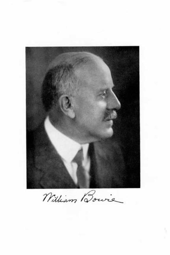
WILLIAM BOWIE
1872-1940
BY J . A. FLEMING
William Bowie was born May 6, 1872, at Grassland, anestate near Annapolis Junction, Anne Arundel County, Mary-land. He died August 28, 1940, at Mt. Alto Hospital in Wash-ington, D. C , after an illness of about three weeks. Funeralservices were held at St. Thomas Episcopal Church, Washing-ton, D. C, August 30, 1940, followed by burial in ArlingtonNational Cemetery.
His family, descended from a long line of English ancestors,many of whom were knighted, was traced back as far as 1325.His American forebears, all of whom played important partsin the history of Maryland, originated with John Bowie, Sr.(1688-T 759), who emigrated from England to America about1705-06. William Bowie's great grandfather Thomas Bowief 1767-1823) was Colonel of the 34th Regiment of the Mary-land forces in the war of i8r2, and his father Thomas JohnBowie (1837-1898) served as Deputy Provost Marshal forPrince Georges County, Maryland, during the Civil War andwas later elected for one term in the House of the MarylandLegislature. William Bowie's mother, Susanna Anderson(Bowie), whose English ancestors have been traced from earlyin the Fourteenth Century, was also descended from a well-known Maryland family, the activities of many of whom helpedmake history in Maryland. On June 28, 1899, William Bowiemarried Elizabeth Taylor Wattles of Alexandria. Virginia, whosurvives him and who is also of illustrious English and Ameri-can ancestry. There were two children, William (deceased ininfancy) and Clagett, an aeronautical engineer and designer,presently of Baltimore, Maryland. Bowie was also survivedby two brothers : Edward Bowie, an eminent meteorologist, whohas since died, and John Bowie, who resides at Grassland, theold family estate.
William Bowie received his early education in the publicschools and at the venerable St. John's College of Annapolis.
61
NATIONAL ACADEMY BIOGRAPHICAL MEMOIRS VOL. XXVI
Maryland. l ie later attended and received degrees from TrinityCollege, Hartford, Connecticut (B.S. 1893; M.A. 1907; Sc.D.1919) and Lehigh University (C.E. 1895; Sc.D. 1922). Healso received honorary degrees (LL.D. 1936) from the Uni-versity of Edinburgh, Scotland, on the occasion of the meetingof the International Union of Geodesy and Geophysics of whichhe was President, and from the George Washington University(Sc.D. 1937).
He entered the service of the United States Coast and Geo-detic Survey on July 1, 1895, first as a junior officer in thefield and later as chief of parties engaged in triangulation andbase-line measurements in many states of the Union as wellas in the Philippines, Puerto Rico, and Alaska. He wasappointed in 1909 as Inspector of Geodetic Work and Chief ofthe Computing Section, which was re-designated as the Divi-sion of Geodesy from October 15, 1915. He rendered distin-guished service in this position until he was retired in May,1936, having reached the age of 64, the retiring age for com-missioned officers of the Survey, but he was recalled to activeduty on June I, 1936, and served until his final retirement onDecember 31, 1936.
During his connection of over 40 years with the Survey hewon distinction both at home and abroad for his notable attain-ments in geodesy, related science, and engineering. Aside fromdirecting the main function of the Computing Section and theDivision of Geodesy, namely, extending control surveys con-sisting of triangulation, leveling, and pendulum and gravitywork, throughout the country, he found time to make researchesin earth-physics which were the basis of many official publica-tions and his well-known book "Isotasy." In addition he pub-licized the general usefulness and public value of surveying andmapping by contributing hundreds of articles to current journalsand newspapers. During World War I, he was commissioneda major in the Corps of Engineers, U. S. Army, and was as-signed to the Mapping Division of the Office of the Chief ofEngineers in Washington (August, 1918, to February, 1919).
Dr. Bowie's scientific activity was directed chiefly toward theaccomplishment of three general objectives: (1) Promotion of
62
WILLIAM BOWIE FLEMING
mapping of the United States and its territories and improve-ment of cartographic methods and technique. (2) Expansionof geodetic work and improvement of instruments and methods.(3) Promotion of interest and progress in geophysical sciences,particularly through the media of national and internationalbodies.
(1) Promotion of Cartography and of Improved Instrumentsand Technique
Earnest advocacy of more and better maps was an outstand-ing feature of Bowie's scientific career. Although from a pro-fessional standpoint his chief interest was in the somewhatlimited field of geodesy, he always viewed his work from thebroad concept of its value and general utility as a part of map-ping which then sorely needed a champion. On this point hebrought to bear all his energy and eloquence, never letting passan opportunity to impress its importance upon his countrymen.To this end he addressed many scientific and engineering so-cieties and contributed articles to newspapers and technicaljournals, always stressing the need for, and the great advantageto be derived from, adequate surveys and maps of the UnitedStates and its outlying territories. For this alone his contribu-tion to posterity merits first consideration, notwithstanding hisgeodetic research for which he received nearly all his honors.He was always ready to support his assertions by citing instancesof losses resulting from the destruction of highway structuresbecause of lack of proper planning where highways had to beextended over unmapped areas. Another of his theses was thedependence on mapping in evaluating available water suppliesand in the solution of certain biological problems. From theeconomic viewpoint he emphasized the fact that good maps andgood control-surveys make possible the execution of our variousenterprises in a more efficient way, thereby reducing the cost toour people of private and public works.
Of great practical advantage to geodetic operations wasBowie's initiation of a movement to place surveying and mappingin North America on a single geodetic datum known as the
63
NATIONAL ACADEMY BIOGRAPHICAL MEMOIRS VOL. XXVI
North American Datum,1 which was adopted by Canada andMexico in 1913. By this the execution of surveys along theircommon borders in a uniform and systematic manner wasassured and a mutual understanding in geodetic matters estab-lished.
The deplorable lack of co-ordination, uniformity, and stand-ardization of methods in the various Governmental organiza-tions engaged in this work could not long escape notice by oneas assiduous as Bowie in the cause of maps and mapping.Working through the National Research Council, he pointedout the unsatisfactory and wasteful duplication of the work.He advocated, as the best means for correcting this condition,the establishment of an agency within the Government to studythe problem and undertake the task of co-ordinating the servicesinvolved. The result of his campaign was the creation in 1919of a Board of Surveys and Maps, later known as the FederalBoard of Surveys and Maps. He was chairman of this Boardduring its early years. This Board rendered useful service tounits engaged in mapping. Its functions were transferred tothe Bureau of the Budget in 1942.
Under Bowie's supervision from October 10, 1909, therewere added many thousand miles of arcs to the triangulation-net of the country. To make an equitable distribution of theclosing errors among the arcs, which, using the old system,would have been impracticable, Bowie suggested the establish-ment of juncture figures and the adjustment of interveningarcs as separate sections. This simplified method was first suc-cessfully applied to the first-order control-arcs in the westernpart of the United States and later to the eastern half.
Bowie was also largely responsible for the organization inthe American Society of Civil Engineers of a Division of Sur-veying and Mapping, of which he was Chairman until 1940.From the work of this Division has come a better appreciationof the economic advantages of good maps and the realization
1 "For all connected triangulation in the United States, Canada, andMexico, the initial point is the Triangulation Station, Meades Ranch, inthe State of Kansas. Its adopted latitude and longitude and the azimuthfrom it to the Station Waldo are called the North American Datum."[W. Bowie, Jour. Frank. Inst, p. 665, June 1914.]
64
WILLIAM BOWIE FLEMING
of their almost universal application to problems of the nationalservices.
(2) Expansion of Geodetic Work and Improvement ofInstruments and Methods
Bowie was placed in charge of the geodetic work of the Surveyon October 10, 1909. At that time 10,000 miles of triangulationand 30,000 miles of leveling had been done. During the 27 yearsof his administration, these figures were raised to 68,000 and261,000 miles, respectively. At the same time the number ofgravity stations was increased from 60 to 720 and astronomicalLaplace stations from about 32 to 390.
It was during this period that great changes in the tempoof field work of the Survey took place. During the earlyyears of the present century, the field-equipment was trans-ported from station to station by mules and horses, and thenecessity of erecting wooden towers rendered progress com-paratively slow. With the advent of the rapid autotruck withall modern conveniences and portable steel towers which couldbe quickly erected and dismounted, the geodetic field workwas greatly improved and its progress accelerated. Bowiequickly envisioned the advantages of these innovations andadopted them in the field work of the Survey.
One of the problems which confronted Bowie pertained tothe procurement of suitable instruments and the recondition-ing of old ones which through usage had become incapable ofyielding results of the accuracy required for first-order tri-angulation. One of the various improvements advocated byBowie, after careful investigation, was the substitution ofsilver circles on the theodolites. This change was suggestedfor the purpose of eliminating any inaccuracy which mightresult from the displacement of the silver inlay originally setin the bronze circles of these instruments. These silver circleswere found to be an important improvement and were gradu-ally adopted for the theodolites of the Survey.
Bowie also improvised in the field a base tape-stretcher ap-paratus which was later improved and manufactured in theSurvey's instrument-shop.
6--,
NATIONAL ACADEMY BIOGRAPHICAL MEMOIRS VOL. XXVI
He was also responsible for improvements in gravity instru-ments and methods. At his suggestion observations were madein 1914 which showed the possibility of using the noon signalstransmitted by the United States Naval Observatory overthe wires of the Western Union Telegraph Company, in thedetermination of the periods of the pendulums in gravity work.Bowie had had much experience in time determinations forlongitude work in which the program of observations at eachstation included an exchange of telegraphic signals with anexisting station for the purpose of eliminating certain errors.He visualized the use of the daily Western Union signals forpendulum gravity determinations where, as was usually thecase, a pendulum gravity station was in reasonable proximityto the telegraph office. The trial of the method in 1914 provedfeasible and it was used thereafter until the development ofnew equipment. This so accelerated gravity observations thata single station could be completed on the average in about oneweek whereas before that time an average of about three weekswas required at each station. Furthermore, only one observerwas required by the new method instead of two.
The subject of isostasy has been under investigation at theUnited States Coast and Geodetic Survey for many years.The first work there was done under the direction of ProfessorJ. F. Hayford, Bowie's predecessor in geodetic operations, inconnection with the deflection of the vertical and the determina-tion of the size and shape of the earth. This work was laterextended to include investigations of the effect of topographyand isostatic compensation upon the intensity of gravity. Theseinvestigations of gravity and isostasy were continued underBowie from 1909 and the results obtained were set forth ina number of publications of the Survey. It was found thatthe theory of isostasy was useful in accounting for abnormalvalues of gravity and for studying underground structure.Isostatic anomalies were shown to indicate a departure fromnormal conditions of specific gravity of the rock underlyingthe point of observation.
Bowie's investigations of gravity paved the way for theuse of determinations of gravity in studying geological struc-
66
WILLIAM BOWIE FLEMING
ture and the gravity method which has proved so valuable ingeophysical exploration.
During the gravimetric survey of Holland, 1912-1922, theswampy nature of certain parts of that country made it impos-sible to find any fixed base for the pendulum apparatus. Meas-ures had to be taken, therefore, for ensuring the accuracyof the observations in spite of the unsteadiness of the instru-ment. A method was accordingly developed by Dr. F. A.Vening Meinesz of swinging two pendulums simultaneously inthe same swinging plane, thereby eliminating the effect of thehorizontal accelerations. The success of this method whenapplied to the unstable terrain of Holland led to the ideathat it could also be applied to ships at sea; experiments per-formed on board submarines while submerged demonstratedthe feasibility of this method for making gravity determina-tions over ocean areas.
Bowie was greatly interested in this improved method indetermination of gravity and warmly encouraged VeningMeinesz in pursuing his observations at sea. He took a leadingpart in arranging collaboration of Vening Meinesz and theDutch authorities with the United States Navy and otherAmerican organizations so that values of gravity at sea mightbe obtained by the United States and other interested govern-ments or organizations. Largely as a result of his efforts, threeexpeditions were successfully concluded in 1928, 1932, and1936-37, chiefly in the vicinity of the West Indies. The resultsof these expeditions confirmed the theories of Airy2 and Pratt3
that the earth's crust under the oceans is in isostatic equilibriumwith the crust in the continent—an idea which was ardentlysupported by Bowie. They also yielded vital supplemental datawhich permitted the interpretation of the geology and geophysicsof the region surveyed.
2 G. B. Airy, On the Computation of the effect of the attraction ofmountain masses as disturbing the astronomical latitude stations in geo-detic surveys. Phil. Trans. Roy. Soc. London, vol. 145, pp. 101-104 (1855).
3J . H. Pratt, On the attraction of the Himalaya Mountains and of theelevated regions beyond them upon the plumb line in India. Phil. Trans.Roy. Soc. London, vol. 145, pp. 53-100 (1855).
07
NATIONAL ACADEMY BIOGRAPHICAL MEMOIRS VOL. XXVi
(3) National and International Activities
Few Americans have wielded so great an influence in nationaland international scientific bodies concerned with geodesy andgeophysics as William Bowie. He was present as the UnitedStates representative at the last General Assembly of the Inter-national Geodetic Association at Hamburg in 1912, when theFiftieth Anniversary of that organization was celebrated. Atthe triennial conventions of that Association representativegeodesists from the twenty or more adhering countries werebrought together and their personal contacts and discussionsresulted in the greatest benefit to the science of geodesy through-out the world.
With the outbreak of World War I, the activities of manyinternational scientific organizations were either suspended orterminated, but the work of the International Geodetic Asso-ciation was continued on a limited scale by the so-called ReducedGeodetic Association to which seven neutral countries, includ-ing the United States, belonged. After the United Statesentered the war in 1917, the work was carried on by the othersix member-nations, to which too much credit cannot be givenfor preventing a break in international co-operation in geodeticmatters during World Wrar I.
Contrary to expectations, the old International Geodetic Asso-ciation was not revived with the return of peace. At a meetingheld in Brussels in 1919, at which Bowie was one of the leadingdelegates from the United States, the International Union ofGeodesy and Geophysics was created and its Section (laterdesignated Association) of Geodesy was destined to replace theold International Geodetic Association. At the first plenarymeeting of the Section at Rome in 1922, all of the countriesforming the Reduced Geodetic Association were represented.
Dr. Bowie was President of the Section of Geodesy from itsestablishment in 1919 until 1933. One of the troublesome ques-tions which soon claimed the attention of the InternationalUnion was the admission of the Central Powers and their alliesto membership. Although several of the European delegateswere, from the first, bitterly opposed to their admission, Bowie
68
WILLIAM BOWIE FLEMING
consistently denounced this limitation to the international char-acter of the Union and, in his capacity as ex-officio Vice-Presi-dent of the Union, threw his influence always on the side oftolerance and international understanding. In 1926, the statutesof the Union were revised and the clauses to which the CentralPowers took umbrage were eliminated.
In all the deliberations of the Union as well as those of the Sec-tion (later Association) of Geodesy, the words of Bowie alwayscarried weight. His dignified bearing and commanding pres-ence assured him the respect of all and his clever diplomacyoften succeeded in bringing about satisfactory settlements ofquestions where prolonged and heated discussion would haveproduced at best a doubtful solution. He was a past masterof the art of conducting a meeting and under his general guid-ance even much-contested matters were often dispatched withsurprising smoothness. He was strongly in favor of workingthrough committees as the best manner of dealing with disputedquestions, since spontaneous debate in international assemblies,where different languages are involved, often becomes inter-minable.
In token of his unusual ability in parliamentary practice,coupled with his high scientific attainments, he was electedPresident of the International Union of Geodesy and Geo-physics from 1933 to 1936. In 1936 he received the degree ofDoctor of Laws from the University of Edinburgh. Becauseof his intimate acquaintance with the affairs of the Union, hewas called upon to act as Secretary, in the absence of BrigadierWinterbotham, at the General Assembly of the Union held inWashington in 1939.
Bowie was instrumental in bringing about the adoption ofthe "Hayford Spheroid," known as the "international spheroid,"at the meeting of the International Union of Geodesy and Geo-physics at Madrid in 1924.
In the minutes of the Executive Committee of the AmericanGeophysical Union one meets with Bowie's name at everyturn because of the prominent part he took in shaping the destinyof the Union and in directing its policies. He was the firstChairman of its Section of Geodesy, holding that post from 1919
69
NATIONAL ACADEMY BIOGRAPHICAL MEMOIRS VOL. XXVI
to 1922. He was General Secretary of the Union from 1929-1932.
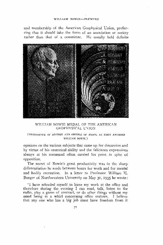
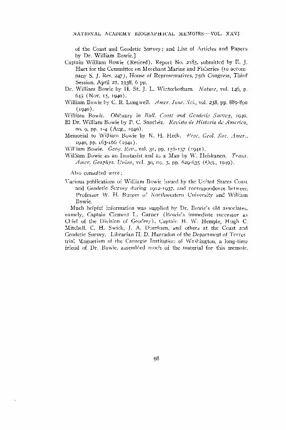
His counsel, wise judgment, and enthusiasm had much todo with the development of the Union (which originally had amembership of only 50 and whose membership at the time ofBowie's death was over 1400, and in 1949 is over 4500) andwith the encouragement of geophysics as a profession through-out the United States. That the Union was not unmindful ofhis outstanding service was attested by the establishment ofthe William Bowie Medal, endowed by friends and co-workers,for award for distinguished attainment and outstanding contri-bution to the advancement of co-operative research in funda-mental geophysics.
The following extract from the citation (April 28, 1939)when the first award of this Medal was made to Bowie, epito-mizes the regard in which he was held by his colleagues.
"It is particularly fitting that the first award of this Medalshould be to the man whose name the Medal bears. It is notnecessary here, among your intimate friends and colleaguesin geophysics, to refer specifically to your long list of scientificaccomplishments and honors. But we do feel that in presentingyou with the first imprint of this Medal that has been createdin your name and that of the organization for which you haveworked so long and so lovingly, we are not handing youmerely a bit of stamped and engraved metal, but rather a power-ful talisman of those human forces, affection, esteem, and tradi-tion so fundamental to your spirit of progress. It is sincerelyhoped that in the years to come this Medal, through its futureawards, will continue to promote and to recognize that spiritof helpfulness and friendliness in unselfish co-operative researchwhich you have so bountifully displayed."
In all deliberations he stood for encouragement of scientificeffort and co-operation with agencies which would advance thecause of geophysics. As a member of the National Academyof Sciences since 1927 he was affiliated with the Section onAstronomy. He did much to interest the Academy in geo-physics and was one of those who took an active part in theorganization and endowment of the Woods Hole OceanographicInstitution. He was a firm advocate of enlarging the scope
70
WILLIAM BOWIE FLEMING
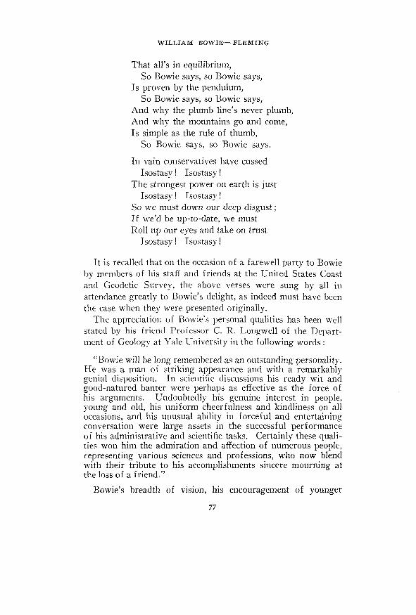
and membership of the American Geophysical Union, prefer-ring that it should take the form of an association or societyrather than that of a committee. He usually held definite
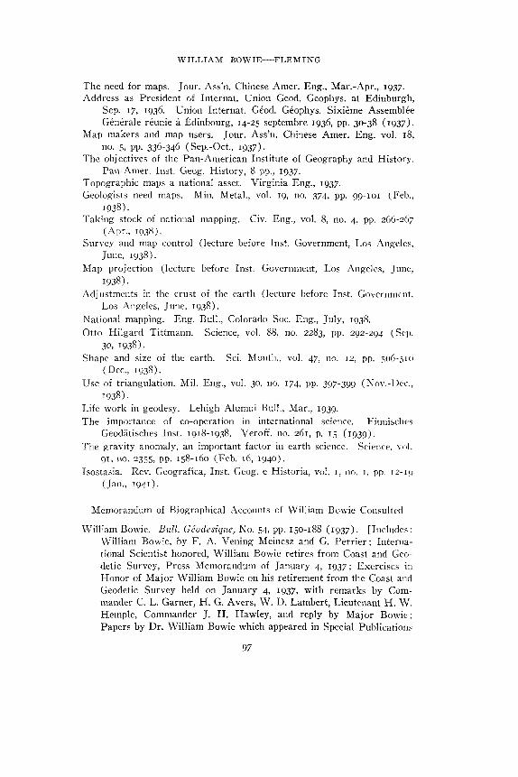
WILLIAM BOWIE MEDAL OF THE AMERICANGEOPHYSICAL UNION
(PHOTOGRAPH OF REVERSE AND OBVERSE OF MEDAL AS FIRST AWARDED
WILLIAM BOWIE.)
opinions on the various subjects that came up for discussion andby virtue of his oratorical ability and the felicitous expressionsalways at his command often carried his point. in spite ofopposition.
The secret of Bowie's great productivity was in the sharpdifferentiation he made between hours for work and for mentaland bodily recreation. In a letter to Professor William H.Burger of Northwestern University on May 31, 1935 he wrote:
"I have schooled myself to leave my work at the office andtherefore during the evening I can read, talk, listen to theradio, play a game of contract, or do other things without mymind being in a whirl concerning office matters. I believethat any one who has a big job must have freedom from it
71
NATIONAL ACADEMY BIOGRAPHICAL MEMOIRS VOL. XXVJ
for some of the day. I try to drive as hard as I can while Iam at the office, but at the close of the official day I am throughuntil the next morning. Under this plan I seem to be standingup in fine shape, as I have written you before."
(4) Leadership
Bowie's scientific ability was enhanced by his rare qualityof leadership—one possessed by so few scientists. It has fallento the lot of few American men of science to be endowed withthe high qualities of leadership and organization which charac-terized Bowie throughout his long career in government service.His unswerving purpose was to build up a unified and contentedgroup of efficient workers as the best way to advance the workin view. He had the rare faculty of effecting the accomplish-ment of his objectives through the co-operative efforts of themen under his direction, a large part of which was due to hishonesty and generosity of bestowing credit where it was due—he thus assured zealous and loyal co-operation in the work.
His popularity as a leader was evidenced on many occasionsbut perhaps never to better advantage than at the time of hisretirement from active service when his Division held a dinnerand exercises in his honor. He was outstandingly successfulas a chief of division and set an example of administrationwhich others in like positions would do well to emulate.
Dr. Bowie took much interest in educational matters andheld very sane views regarding public instruction, insisting thatthe object of study was to understand the subject and not toover-strive to obtain good marks.
Some of his cogent ideas on the subject are illustrated in thefollowing extracts from letters to Professor Burger:
"I am inclined to think that your success with the CoastSurvey and since may be due to the fact that you took a generalscience course rather than an engineering one. Hayford wasquite convinced that the strictly engineering courses did notgive a man a well-rounded education. I am becoming moreconvinced than ever that we should have in an engineeringcourse more physics, mechanics, mathematics, English, history,and perhaps philosophy and economics. They are the thingsthat enable one to understand life. Learning how to buildbridges and highways, etc., makes men too narrow unless they
WILLIAM BOWIE FLEMING
have these other things. When Hay ford went to Northwesternhe started the five-year course in order that the students wouldhave some cultural courses. In this he was sound.
"These fundamental things that I have mentioned above arethe basis of all engineering. A man well grounded in thesefundamentals can soon learn the technical phases of any engi-neering job to which he may be called. I find in the Division ofGeodesy that our field men who have had special courses inphysics while in their Colleges and Universities are able tohandle our work a little better than those who took merely struc-tural and construction courses." (June 13, 1935.)
"I think there is too much attention paid by students at highschools and universities to marks. They think if they get agood mark they are doing good work. As a matter of fact themark may be due merely to cramming for the recitation or thequiz without any real intention of understanding what thesubject is all about.
"I am inclined to favor the system used at the Harvard LawSchool. They do have recitations in a sense. The students arerequired to get up and talk about certain cases and naturallythey do not like to make a mess of it. But no marks are givenor taken into consideration during the entire year. At the endof the year a comprehensive examination is given in each subjecttaken. The examination questions are designed to show whethera student really understands his subject and the fundamentalprinciples of law. There are scarcely any questions involvingmerely memory tests. This it seems to me is the ideal way ofconducting any course. Then the student tries to learn some-thing about it rather than to get by in daily recitations andoccasional quizzes.
"I believe outside activities of the school and college, if notoverdone, are a great benefit to the student. After all whenwe get through college our dealings are principally with peo-ple and not with things. Of course we must know fundamentalprinciples of science or anything else that we study, but deal-ing with people is very important. If one goes through collegewithout contacting other students in extra-curricular activities,he is very much handicapped when he gets out into the world'swork. I find that men who have had such extra-curricular workin college make better chiefs of parties. They know how tohandle men, to pep up their morale, and to make them enjoya rough and tumble life." (December 27, 1935.)
Despite his official responsibilities Bowie found time to dosome teaching outside of the Coast and Geodetic Survey. From
73
NATIONAL ACADEMY BIOGRAPHICAL MEMOIRS VOL. XXVI
1912 to 1917 he conducted a short course in geodetic surveyingand practical astronomy at Columbia University summer sur-veying camp near Litchfield, Connecticut. He was also speciallecturer at Lehigh University from 1924 to 1936. He neverlost an opportunity to urge young men to make the most ofthe best in them and to encourage them to strive for leadershipin their chosen work.
He was also an excellent public speaker and brilliant con-versationalist, being never at a loss for something to say andhow to say it. He was much given to citing telling examplesto reinforce his statements. In an address given before theSouth Carolina Society of Engineers, in emphasizing the inade-quacy of some descriptions of land-marks, in connection withhis campaign for better maps, he cited an old deed which read"Beginning at a point on Powdermill Hill where Bill Joneskilled the Indian." Another instance of his shrewd humormay be noted in a conversation with one of his friends when hesaid by way of precept: "If you want to make a name for your-self in science, choose for investigation some subject whichnobody knows anything about and which, moreover, nobodycares anything about, such as isostasy. Then you will receivebouquets instead of bricks!"
(5) Affiliation with Scientific Bodies, Honors, and Awards
Scientific bodies—Bowie was interested in many scientificsocieties and organizations, to which he contributed much ofhis time, both as an active and as an honorary member. Amongthem may be mentioned the following:
National Academy of SciencesNational Research Council in its Division of Foreign
RelationsAcademy of Sciences of the Institute of FranceAcademy of Sciences of NorwayNational Academy of History and Geography of MexicoRussian Geographical SocietyFinnish Geographical Society (Honorary membership had
been unanimously voted but Bowie's death occurred beforeits finalization)
74
WILLIAM BOWIE FLEMING
International Union of Geodesy and Geophysics (President,1933-36)
International Association of Geodesy (President, 1919-33)Federal Board of Surveys and Maps (Chairman, 1922-24,
member of Executive Committee, 1920-36)American Society of Civil Engineers (Chairman of Division
of Surveying and Mapping from its organization in 1926)American Institute of Consulting EngineersAmerican Geographical SocietyAmerican Association of GeographersAmerican Astronomical SocietyAmerican Engineering Council (Committee on Surveying and
Mapping)American Society of PhotogrammetryAmerican Geophysical Union (President, 1919-22 and 1929-
3 2 ) .American Association for the Advancement of SciencePan American Institute of Geography and History (Honorary
President from 1929)Society of American Military Engineers (President, 1938,
and Executive Officer and Editor of The Military Engineerfrom January 1-August 28, 1940)
Geological Society of AmericaGeological Society of WashingtonNational Geographic SocietyPhilosophical Society of Washington (President, 1926)Seismological Society of AmericaSouth Carolina Society of Civil EngineersWashington Academy of Science (President, 1930)Washington Society of Engineers (President, 1914)
He was a member of the following Greek-letter fraternities:Delta Kappa EpsilonPhi Beta KappaSigma Xi (President, District of Columbia Chapter, 1935-36)
He enjoyed memberships in the following clubs:Cosmos Club of Washington (life member)Army and Navy Club of Washington
75
NATIONAL ACADEMY BIOGRAPHICAL MEMOIRS VOL. XXVI
Honorary awards and medals—Recognition of Bowie's sci-entific activities, other than awards of honorary degrees, maybe noted as follows:
The Charles Lagrange Prize by the Royal Academy of Bel-gium in 1932
The Elliott-Cresson Medal by the Franklin Institute of Phila-delphia in 1937 for contributions to the science of geodesy
Medal and Diploma as an Officer of Orange-Nassau by theQueen of The Netherlands in 1937 [The Medal andDiploma of the Order were presented through the Ministerof The Netherlands at Washington with the followingcitation: "In recognition of outstanding achievements inthe interests of international science and geodesy and hiscollaboration with Dr. F. A. Vening Meinesz, Professorof Geodesy at the University of Utrecht, The Netherlands,and a Member of The Netherlands Geodetic Commission,in the determination of gravity at sea."]
Decoration of the Cross of Grand Officer of the Order of St.Sava from Yugoslavia in 1939
First award of the William Bowie Medal by the AmericanGeophysical Union in 1939
Sometimes the development of regard of scholars in otherfields is reflected in doggerel rhymes so often used in friendlyget-together meetings. Thus as regards Bowie's work in isostasyin the earlier days, about a quarter-century ago, before the geolo-gist had altogether accepted isostasy, at a meeting of the Geo-logical Society of Washington during December, 1923, HenryG. Ferguson and Frank C. Calkins submitted the followingverses, which were sung to the tune of "Maryland, My Mary-land" by the chorus of the Pick and Hammer Club:
What is it rules the upper crust?Isostasy! Isostasy!
What actuates the overthrust?Isostasy! Isostasy!
What gives the shore-line wanderlust ?What humbles highlands in the dust ?What makes the strongest stratum bust ?
Isostasy! Isostasy!
76
WILLIAM BOWIE FLEMING
That all's in equilibrium,So Bowie says, so Bowie says,
Is proven by the pendulum,So Bowie says, so Bowie says,
And why the plumb line's never plumb,And why the mountains go and come,Is simple as the rule of thumb,
So Bowie says, so Bowie says.
In vain conservatives have cussedIsostasy! Isostasy!
The strongest power on earth is justIsostasy! Isostasy!
So we must down our deep disgust;If we'd be up-to-date, we mustRoll up our eyes and take on trust
Isostasy! Isostasy!
It is recalled that on the occasion of a farewell party to Bowieby members of his staff and friends at the United States Coastand Geodetic Survey, the above verses were sung by all inattendance greatly to Bowie's delight, as indeed must have beenthe case when they were presented originally.
The appreciation of Bowie's personal qualities has been wellstated by his friend Professor C. R. Longwell of the Depart-ment of Geology at Yale University in the following words :
"Bowie will be long remembered as an outstanding personality.He was a man of striking appearance and with a remarkablygenial disposition. In scientific discussions his ready wit andgood-natured banter were perhaps as effective as the force ofhis arguments. Undoubtedly his genuine interest in people,young and old, his uniform cheerfulness and kindliness on alloccasions, and his unusual ability in forceful and entertainingconversation were large assets in the successful performanceof his administrative and scientific tasks. Certainly these quali-ties won him the admiration and affection of numerous people,representing various sciences and professions, who now blendwith their tribute to his accomplishments sincere mourning atthe loss of a friend."
Bowie's breadth of vision, his encouragement of younger
77
NATIONAL ACADEMY BIOGRAPHICAL MEMOIRS VOL. XXVI
men, his interest in other than his immediate field, his unselfishservice in his every contact, and his unflagging zeal and devo-tion to bring together the seven main fields of geophysics as areal Union endear and perpetuate his memory, not only to hisown countrymen but to all of those many colleagues in almostevery country of the world who had the privilege of his ac-quaintance.
78
WILLIAM BOWIE FLEMING
BIBLIOGRAPHY OF WILLIAM BOWIEBY J. A. FLEMING AND H. D. HAREADON
It has been difficult to prepare a complete bibliography of publicationsand writings by Bowie. In the preparation of the following material theauthors have had the generous assistance of Captain H. W. Hemple,presently Chief of the Division of Geodesy of the Coast and GeodeticSurvey, of his assistants, and of the Librarian of the Survey. As will benoted, there are included, in addition to major scientific reports andaddresses, numerous reviews, abstracts, and articles in newspapers; thusthe increasing tempo of Bowie's activities, both as a scientist and as apublic spirited citizen, is clearly indicated. Some of his publications doubt-less have been omitted from this list, but such omissions are probably fewin number.
Abbreviations used in references follow general conventions but inorder to avoid any ambiguity, they are indicated in the key below:
Abbr'n. Meaning Abbr'n.Abs. Abstract Frank.
Abstracted Gaz.Adv. Advancement Geod.Aeron. Aeronautical Geod.Amer. America Geog.
TranslationObservatory U. S. United Statespage vol. volumepages Wash. Washington, D.C.Petroleum Zs. Zeitschrift
Sep. SeptemberOct. OctoberNov. NovemberDec. December
NationalNationalenumber
79
NATIONAL ACADEMY BIOGRAPHICAL MEMOIRS VOL. XXVI
Some recent triangulation in the southwest part of the United States(presented before Phil. Soc. Wash., Mar. 10, 1910).
Determination of the height and geographical position of Mt. McKinley.Bull. Amer. Geog. Soc, vol. 42, no. 4, pp. 260-261 (Apr., 1910).
Primary triangulation and base measurement by the Coast and GeodeticSurvey (presented before Phil. Soc. Wash., in 1910).
The measurement of two primary base lines with invar tapes (presentedbefore Phil. Soc. Wash., Jan. 28, 1911). Eng. News-Record, vol. 65,no. n , p. 315 (Mar. 16, 1911).
The Texas-California arc of primary triangulation. Abs., Science, vol.33, no. 849, pp. 838-839 (Apr. 7, 1911) ; also abs. Bull. Amer. Geog.Soc, vol. 43, no. 6, pp. 447-448 (June, 1911).
The completion of Texas-California arc of primary triangulation. Abs.,Science, vol. 33, no. 854, pp. 748-750 (May 12, 1911) ; Amer. Geog.Soc, (June, 1911) ; Sci. Amer. Supp., vol. 74, p. 412 (Dec. 28, 1912).[Rev. by Dr. E. Hammer, Petermann's Mitteil., p. 209, Apr., 1913.]
Recent gravity-work by the Coast and Geodetic Survey (presented beforePhil. Soc. Wash., May 6, 1911). Abs., Science, vol. 33, no. 858, pp.911-912 (June 9, 1911).
Recent gravity work in the United States. Amer. Jour. Sci., vol. 32,pp. 101-113 (Aug., 1911).
Primary base lines at Stanton, Texas, and Deming, New Mexico. Ann.Rep. U. S. Coast Geod. Surv., 1910, App. 4, pp. 143-171, Gov. Print-ing Office, 1911.
Making practical use of the U. S. primary triangulation systems (pre-sented before Amer. Ass'n. Adv. Sci., Sec. D, Wash., Dec. 28, 1911).Eng. News, vol. 67, no. 8, p. 341 (Feb. 22, 1912).
Some relations between gravity anomalies and the geologic formationsin the United States. Amer. Jour. Sci., vol. 33, pp. 237-240 (Mar.,1912).
Some results of the Hayford method of gravity reductions. Jour. Wash.Acad. Sci., vol. 2, no. 21, pp. 499-504 (Dec. 19, 1912).
Effect of topography and isostatic compensation upon the intensity ofgravity [with J. F. Hayford]. Spec. Pub'n. 10, U. S. Coast Geod.Surv., 132 pp., 1912.
Texas-California arc of primary triangulation. Spec. Pub'n. 11, U. S.Coast Geod. Surv., 141 pp., 1912. [Rev. in Bull. Amer. Geog. Soc,vol. 45, no. 1, p. 54 (Ja«-» T9i3)-]
Effect of topography and isostatic compensation upon the intensity ofgravity. Spec. Pub'n. 12, U. S. Coast Geod. Surv., 28 pp. with 5maps, 1912. [Rev. as "Gravity publications" by Dr. Kohlschiitter,Petermann's Mitteil., p. 260, May, 1913.]
The precise level net of the United States. Eng. News, vol. 69, no. 16,p. 775 (Apr. 17, 1913).
80
WILLIAM BOWIE FLEMING
The 17th general conference of the International Geodetic Association.Bull. Amer. Geog. Soc, vol. 45, no. 5, pp. 351-356 (May, 1913).
The adoption of the North American Datum. Bull. Amer. Geog. Soc,vol. 45, no. 8, p. 614 (Aug., 1913).
Determination of time, longitude, latitude and azimuth. Spec. Pub'n. 14,U. S. Coast Geod. Surv., 177 pp., 1913 [Rev. by David Rines, Science,vol. 38, no. 980, pp. 515-518 (Oct. 10, 1913).]
Isostasy (presented at Naval Observatory, Washington, Jan. 16, 10.14).Washington Society of Engineers (presented before Baltimore Soc. Eng.,
Feb. 24, 1914).Isostasy and the size and shape of the earth (address at Atlanta, Georgia,
with supplement, Dec. 20, 1913). Science, vol. 39, no. 1011, pp. 695-707 (May 15, 1914).
Isostasy in India (presented before Phil. Soc. Wash., Apr. 11, 1914).Abs., Jour. Wash. Acad. Sci., vol. 4, no. 10, pp. 245-249 (May 19,1914).
Some geodetic evidence of isostasy. Abs., Jour. Wash. Acad. Sci., vol. 4,pp. 382-383 (1914).
The substitution of metal tapes and wires for bars in base measurements.Jour. Frank. Inst., vol. 177, no. 6, pp. 665-672 (June, 1914).
Recent development of precise leveling in the United States (presentedto Amer. Ass'n. Adv. Sci., Sec. D., Philadelphia, Dec. 31, 1914).
Fourth general adjustment of the precise level net of the United States[with H. G. Avers]. Spec. Pub'n. 18, U. S. Coast Geod. Surv., 328pp., 1914.
Primary triangulation along the 104th meridian and along the 39th parallelin Colorado, Utah and Nevada. Spec. Pub'n. 19, U. S. Coast Geod.Surv., 141 pp., 1914.
Precise leveling from Brighen, Utah, to San Francisco, California. Spec.Pub'n. 22, U. S. Coast Geod. Surv., 67 pp., 1914.
Symposium on the factors producing change in positions of strandline dur-ing Pleistocene and Post-Pleistocene (discussion Geol. Soc. Wash.,Mar. 24, 1915). Abs., Jour. Wash. Acad. Sci., vol. 5, no. 12, p. 446(June 19, 1915).
Astronomical and geodetic work in Alaska (unpublished address of June23, I9I5)-
The geodetic work of the Coast and Geodetic Survey (presented beforePhil. Soc. Wash., Apr. 10, 1915). Abs., Jour. Wash. Acad. Sci., vol.5, no. 15, p. 557 (1915).
The errors in precise leveling due to irregular atmospheric refractions.Science, vol. 42, no. 1090, pp. 712-718 (Nov. 19, 1915).
Omaha's position on the earth's surface. The Omaha Bee, Feb., 1916.Determination of the intensity of gravity on land in the United States
The one hundredth anniversary of the United States Coast and GeodeticSurvey—Account of celebration. Science, vol. 43, no. 1115, pp. 655-656 (May 12, 1916).
Review of "The elements of surveying and geodesy" by W. C. Popplewell(London). Science, vol. 43, no. 1120, pp. 856-857 (June 16, 1916).
The contributions of geodesy to geography. Geog. Rev., vol. 2, no. 5,pp. 342-353 (Nov., 1916) ; Sci. Amer. Suppl., vol. 83, no. 2145, pp.82-83 (Feb. 10, 1917).
Modern methods of precise leveling by the U. S. Coast and GeodeticSurvey. Eng. and Contracting, vol. 47, no. 5 (Jan. 31, 1917).
The gravimetric survey of the United States. Proc. Nation. Acad. Sci.,vol. 3, no. 3, pp. 171-177 (Mar., 1917).
Our present knowledge of isostasy (presented before Phil. Soc. Wash.,Mar. 17, 1917). Abs., Jour. Wash. Acad. Sci., vol. 7, no. 9, pp. 269-270 (May 4, 1914).
Some evidences of isostasy (presented before Geol. Soc. Wash., Mar.14, 1917). Abs., Jour. Wash. Acad. Sci., vol. 7, no. 10, pp. 311-312(May 19, 1917).
Local versus regional distribution of isostatic compensation. Amer. Jour.Sci., vol. 43, pp. 471-475 (June, 1917).
Review of "Mean Sea Level at Datum for Elevations" by E. Lester Jones.Science, vol. 46, no. 1181, pp. 164-166 (Aug. 17, 1917).
Our present knowledge of isostasy from geodetic evidence. Jour. Geol.,vol. 25, no. 5, pp. 422-445 (July-Aug., 1917) ; abs., Jour. Wash. Acad.Sci., vol. 7, pp. 267-268 (1917).
Investigations of gravity and isostasy. Spec. Pub'n. 40, U. S. CoastGeod. Surv., 196 pp. with 9 maps, 1917. [Abs. in Jour. Wash. Acad.Sci., vol. 7, no. 6, pp. 159-160 (1917).]
Specifications and instructions for preparation fire control and trainingmaps. Chief Eng. U. S. Army, Reproduction Plant, WashingtonBarracks, D. C, 4610, 44 pp., 1917 (?) .
Primary triangulation and precise leveling as done by the Coast andGeodetic Survey (presented before Phil. Soc. Wash., Jan. 5, 1918).Abs., Jour. Wash. Acad. Sci., vol. 18, no. 4, p. 105 (Feb. 19, 1918).
Oceanography in the Coast and Geodetic Survey (address at CosmosClub, Washington, in honor of Dr. Frithof Nansen, Feb. 26, 1918).
The advantage of having maps. Memo. Mar 7, 1919.Mapping the United States for civil and military needs (presented before
Report on the connection of the arcs of primary triangulation, Texas andMexico. Spec. Pub'n. 54, U. S. Coast Geod. Surv., 93 pp., 1919.
Grid system for progressive maps in the United States [with O. S.Adams]. Spec. Pub'n. 59, U. S. Coast Geod. Surv., 227 pp., 1919.[Abs., Jour. Wash. Acad. Sci., vol. 9, no. 19, pp. 597-598 (Nov. 19,I9I9)-]
82
WILLIAM BOWIE FLEMING
Board of Surveys and Maps of the Federal Government. Science, vol.Si, no. 1314, pp. 233-235 (Mar. 5, 1920).
Present status of geodesy and some of the problems of this branch ofgeophysics. Proc. Nation. Acad. Sci., vol. 6, no. 10, pp. 545-555 (Oct.15, 1920). [Rep. Circ. Ser., Nation. Res. Council, no. 11, pp. 545-555 (Oct., 1920).]
The Kilauea Volcanic Observatory [with others] (Report of a Commit-tee of the Nation. Acad. Sci.). Proc. Nation. Acad. Sci., vol. 6,no. 12, pp. 706-710 (Dec. 15, 1920).
Some geological conclusions from geodetic data. Proc. Nation. Acad.Sci., vol. 7, no. 1, pp. 23-28 (Jan., 1921). [Rev. in Sci. Amer. (Sep.,1921).]
The Pan Pacific Scientific Congress (presented before Phil. Soc. Wash.,Oct. 23, 1920). Abs., Jour. Wash. Acad. Sci., vol. 11, no. 7, pp. 165-166 (Apr. 4, 1921).
The relation of isostasy to uplift and subsidence. Amer. Jour. Sci., vol.2, no. 7, pp. 1-20 (July, 1921).
The topographical map of the United States. Geog. Rev., vol. 11, no. 3,p. 441 (July, 1921).
Research in geodetic work in the Pacific. Proc. First Pan-Pac. Sci. Conf.,1920, Bernice P. Bishop Mus., Spec. Pub'n. 7, Part 2, p. 452 ff. (1921).
Ocean currents and isostasy. Proc. First Pan-Pac. Sci. Conf., 1920,Bernice P. Bishop Mus., Spec. Pub'n. 7, Part 2, p. 503 ff. (1921).
The bearing of geodetic investigations on the geologic structure of thePacific. Proc. First Pan-Pac. Sci. Conf., 1920, Bernice P. BishopMus., Spec. Pub'n. 7, Part 3, pp. 882-885 (1921).
Remarks on symposium of training scientists for Pacific work. Proc.First Pan-Pac. Sci. Conf., 1920, Bernice P. Bishop Mus., Spec. Pub'n.7, Part 3, p. 926 (1921).
Scientific phases of charting waters and mapping the land (address beforeAmer. Ass'n. Adv. Sci., Sec. D, Toronto, Canada, 1921).
Mapping and charting (address before Amer. Ass'n. Adv. Sci., Sec. D,Toronto, Canada, 1921).
The yielding of the earth's crust (presented before Phil. Soc. Wash.,Mar. 11, 1922). Ann. Rep. Smith. Inst'n. 1921, Pub'n. 2683, pp. 235-247, 1922; abs., Jour. Wash. Acad. Sci., vol. 12, no. 11, pp. 269-270(June 4, 1922).
Theory of isostasy—A geological problem (lecture at Nation. Bur. Stand.,Oct. 31, 1921). Bull. Geol. Soc. Amer., vol. 33, no. 2, pp. 273-286(June 30, 1922).
The earth's crust and rsostasy. Geog. Rev., vol. 12, no. 4, pp. 613-627(Oct., 1922). [Rev. in Scot. Geog. Mag., vol. 39, no. 2 (Apr. 16,1923)-]
Geodetic operations in the United States, January 1, 1912, to December31, 1921 (Rome report). Spec. Pub'n. 81, U. S. Coast Geod. Surv.,
83
NATIONAL ACADEMY BIOGRAPHICAL MEMOIRS VOL. XXVI
26 pp., 1922. [Rev. by J. F. Hayford in Science, vol. 55, no. 1433,pp. 645-646 (June 16, 1922).]
Report on meetings of International Geodetic and Geophysical Union(presented before Phil. Soc. Wash., Oct. 21, 1922). Abs., Jour.Wash. Acad. Sci., vol. 13, no. 3, p. 43 (Feb. 4, 1923).
Ignorance of the world's natural resources as a cause for wars. Advocateof Peace, vol. 85, pp. 58-59 (Feb., 1923).
Board of Surveys and Maps. Science, vol. 57, no. 1476, pp. 436-437(Apr. 13, 1923).
The present status of geodetic work in the United States and its valueto geology. Amer. Jour. Sci., vol. 5, pp. 378-382 (May, 1923).[Abs. in Bull. Geol. Soc. Amer., vol. 34, no. 1, p. 74 (Mar., 1923).]
Review of Nansen's "The Strandflat and Isostasy." Amer. Jour. Sci.,vol. 5, no. 29, pp. 428-432 (May, 1923).
Some recent progress in isostatic investigations (address before Amer.Geophys. Union, Apr. 19, 1923). Jour. Wash. Acad. Sci., vol. 13,no. 13, pp. 267-270 (July 19, 1923) ; abs., Bull. Nation. Res. Council,vol. 7, part 5, no. 41, pp. 95-96 (Jan., 1924).
Remarking of the initial point for surveys and maps in North America.Geog. Rev., vol. 13, no. 3, p. 465 (July, 1923).
Mapping the Pan-Pacific area. Bull. Pan-Pac. Union, 43, pp. 11-12 (1923).Isostatic investigations and data for gravity stations established in the
United States in 1915. 1923 (?) .Study of time errors in precise longtitude determinations by U. S. Coast
and Geodetic Survey. Spec. Pub'n. 92, U. S. Coast Geod. Surv., 9PP-, 1923-
Geodetic and topographic mapping. Eng. News-Record, vol. 92, no. 3,p. i n (Jan. 17, 1924).
Abnormal densities in the earth's crust disclosed by analysis of geodeticdata. Geog. Jour., vol. 63, no. 1, pp. 26-33 (Jan-> 1924). [Rev. inAmer. Jour. Sci., Apr., 1924, and in Nature, vol. 112, no. 2823, pp.843-844 (Dec. 8, 1923).]
General conference of the International Geodetic and Geophysical Union(in "Report of Meeting of the International Geodetic and GeophysicalUnion and Its Sections Held at Rome, May 2-10, 1922"). Bull.Nation. Res. Council, vol. 7, part 5, no. 41, pp. 27-29 (Jan., 1924).
Report of the Section of Geodesy [in "Report of Meeting of the Inter-national Geodetic and Geophysical Union and Its Sections Held atRome, May 2-10, 1922"] Bull. Nation. Res. Council, vol. 7, part 5,no. 41, pp. 29-32 (Jan., 1924).
Precise triangulation and level nets of United States. Eng. News-Record,vol. 92, no. 8, p. 330 (Feb. 21, 1924).
The accuracy of longitude determinations by the U. S. Coast and GeodeticSurvey by wire signals and General Feme's proposed radio longi-tude net. Abs., Bull. Nation. Res. Council, vol. 7, part 5, no. 41,pp. 87-88 (Jan., 1924).
WILLIAM BOWIE FLEMING
Some recent progress in isostatic investigations (presented at FourthAnnual Meeting of the American Geophysical Union, Washington,D. C, Apr., 1923, before the Section of Geodesy). Abs., Bull. Nation.Res. Council, vol. 7, part 5, no. 41, pp. 95-96 (Jan., 1924).
Earth movements in California as disclosed by triangulation (abs., withdiscussion by A. Keith, L. C. Graton, and A. C. Lawson). Hull.Geol. Soc. Amer., vol. 35, no. 1, pp. 60-62 (Mar. 30, 1924) ; abs.,Pan-Amer. Geol., vol. 41, no. 2, pp. 134-135 (Mar., 1924).
Mountain building without loss of isostatic equilibrium (abs., with dis-cussion by F. P. Shepard and W. H. Hobbs). Bull. Geol. Soc. Amer.,vol. 35, no. 1, pp. 62-63 (Mar. 30, 1924) ; abs. Pan-Amer. Geol.,vol. 41, no. 2, p. 135 (Mar., 1924).
Tertiary history of the north Atlantic Ocean (abs., with discussion byW. P. Woodring, Charles Schuchert, A. C. Lawson, and W. H.Hobbs). Bull. Geol. Soc. Amer., vol. 35, no. 1, pp. 84-85 (Mar. 30,1924) ; abs., Pan-Amer. Geol., vol. 41, no. 2, pp. 142-143 (Mar.,1924).
The function of geodesy in surveying. Mil. Eng., vol. 16, no. 6, pp. 140-143 (Mar.-Apr., 1924).
Review of "Geodetic Evidence for the Supposed Westerly Drift of Green-land" by Col. Sir Charles Close. Amer. Jour. Sci., vol. 7, pp. 332-333 (Apr., 1924).
Stability of geodetic bench marks in United States—Results by U. S.Coast and Geodetic Survey in locations showing elevation changeis of value to construction. Eng. News-Record, vol. 92, no. 18, p.762 (May 1, 1924).
The use of geodetic measurements in detecting horizontal and verticalearth movements. Jour. Wash. Acad. Sci., vol. 14, no. 10, pp. 21-29(May 19, 1924).
Isostasy in Holland. Amer. Jour. Sci., vol. 7, pp. 405-410 (May, 1924).Gravity results in the MacKenzie Basin. Amer. Jour. Sci., vol. 7, pp.
On the size of the block of the earth's crust which may be independentlyin isostatic equilibrium. Jour. Wash. Acad. Sci., vol. 14, no. 15,PP- 355-362 (Sep. 19, 1924).
The importance of isostasy in geodetic research. Bull. Geodesique,Union Internat. Geod. Geophys., no. 3, pp. 194-213 (July-Sep., 1924).
Gravity observations on Indian Ocean and the results of their isostaticreduction. Nature, vol. 114, no. 2878, pp. 930-931 (Dec. 27, 1924).
The accuracy of longitude determinations by the Coast and Geodetic
85
NATIONAL ACADEMY BIOGRAPHICAL MEMOIRS VOL. XXVI
Survey and General Feme's proposed longitude net. Proc. Pan-Pac.Sci. Cong., Australia, 1923, vol. 2, pp. 516-518 (1924).
Practical and scientific value of geodetic surveys. Proc. Pan-Pac. Sci.Cong., Australia, 1923, vol. 2, pp. 557-563 (1924).
The limiting depth of earthquake foci as indicated by seismic investiga-tions. Proc. Pan-Pac. Sci. Cong., Australia, 1923, vol. 2, pp. 575-580(1924).
Isostasy: Its importance in geological and geophysical investigations andresearch. Proc. Pan-Pac. Sci. Cong., Australia, 1923, vol. 2, pp.1165-1168 (1924).
The theory of isostasy in its relation to major earth movements. Proc.Pan-Pac. Sci. Cong., Australia, 1923, vol. 2, pp. 1360-1366 (1924).
Isostatic investigations and data for gravity stations established in theUnited States since 1915. Spec. Pub'n. 99, U. S. Coast Geod. Surv.,iv + 91 pp., 1924. [Rev. Nature, vol. 114, no. 2872, pp. 730-731(1924); also Amer. Jour. Sci., vol. 8, no. 43, p. 98 (July, 1924).]
Geodetic operations in the United States and outlying possessions, Janu-ary 1, 1922, to December 31, 1923 (Madrid report). Spec. Pub'n.104, U. S. Coast Geod. Surv., iv + 28 pp., 1924.
Earth movements in California. Spec. Pub'n. 106, U. S. Coast Geod.Surv., 22 pp., 1924.
A gravimetric test of the "Roots of Mountains" theory. Ser. Pub'n. 291,U. S. Coast Geod. Surv., 8 pp., 1924.
Scientist suggests inventory of goods in world as surest guarantee ofpeace. Nation. News Serv. Weekly, Feb. 15, 1925.
Results of meeting of Section of Geodesy held at Madrid in Septemberand October, 1924, which are of geological interest. Amer. Jour.Sci., vol. 9, pp. 180-186 (Feb., 1925).
The causes and prediction of earthquakes. Science, vol. 61, no. 1580, pp.379-382 (Apr. 10, 1925).
Board of Surveys and Maps and aeronautics. Nation. Aeron. Ass'n.Rev., vol. 3, no. 4, pp. 56, ff. (Apr., 1925).
Isostasy at Madrid meetings of International Union of Geodesy and Geo-physics. Pan-Amer. Geol., vol. 43, no. 5, pp. 337-344 (June, 1925).
Report of the Section of Geodesy [in "Report of the International Geo-detic and Geophysical Union, and Its Sections at Madrid, October1-10, 1924"]. Bull. Nation. Res. Council, vol. 10, part 3, no. 53, pp.14-16 (July, 1925).
Scientists to weigh "floating" earth crust—Dutch geodesists will usesubmarine to test truth of new theory. New York Times, Sep. 6, 1925.
Scientists to test "drift" of continents. New York Times, Sep. 20, 1925;most of this article under title "Are the Continents Anchored ?"appeared in The World Rev., Sep. 28, 1925.
The results of the meeting of the Section of Geodesy of the Internat.Union of Geod. and Geophys. of interest to astronomers. Pop. Astr.,vol. 33, no. 7, pp. 423-430 (Aug.-Sep., 1925).
86
WILLIAM BOWIE FLEMING
Volcanic science to make earth safer. New York Times, Oct. n , 1925.How mountains are made (radio talk, Apr. 15, 1925). Sci. Month., vol.
21, no. 10, pp. 404-408 (Oct., 1925).Mapping the earth (talk before Washington Women's Club, Nov., 1925).The ups and downs of the earth (radio talk, Dec. 3, 1925).Isostasy in the Southern Pacific. Jour. Wash. Acad. Sci., vol. 15, no. 20,
pp. 445-450 (Dec. 4, 1925). [Rev. in Nature, vol. 117, no. 2937, p.246 (Feb. 13, 1926).]
The deflection of the vertical in Porto Rico. Jour. Wash. Acad. Sci.,vol. 16, no. 2, pp. 29-3! (Jan. 19, 1926).
Geology from the isostatic viewpoint. Sci. Month., vol. 22, no. 1, pp. 5-18(Jan., 1926).
Isostasy in Western Siberia. Amer. Jour. Sci., vol. 11, pp. 113-118 (Feb.,1926). [Rev. in Nature, vol. 117, no. 2941, p. 395 (Mar. 13, 1926).]
Eliminating drag effect in triangulation. Mil. Eng., vol. 18, no. 97, pp.34-35 (Jan.-Feb., 1926).
Proposed theory, in harmony with isostasy, to account for major changesin the elevation of the earth's surface. Gerlands Beitr. Geophysik,vol. 15, no. 2, pp. 103-115 (1926).
Mapping the sky-ways. Western Flying, pp. 7, 28-29, Feb., 1926.Notes on the Airy on "Roots of Mountains" theory. Science, vol. 63,
no. 1632, pp. 371-374 (Apr. 9, 1926).Earthquakes from the isostatic viewpoint. Jour. Wash. Acad. Sci., vol.
16, no. 9, pp. 245-250 (May 4, 1926).The work of the Coast and Geodetic Survey. Cornell Civ. Eng., p. 193,
May, 1926; rep. (somewhat abridged) under title "The Coast andGeodetic Survey," Tech. Eng. News, Mass. List. Tech., pp. 168-171,188, 200 (Oct., 1926).
Submarine used to study gravity of ocean beds. U. S. Daily News, Sep.16, 1926.
Pendulum observations between Holland and Java. Amer. Jour. Sci.,vol. 12, pp. 273-274 (Sep., 1926).
Isostatic reductions of Spanish gravity stations. Amer. Jour. Sci., vol.12, pp. 354-356 (Oct., 1926). [Rev. in Nature, vol. 119, no. 2983(Jan. 1, 1927).]
Long lines of triangulation. Geog. Rev., vol. 16, no. 4, pp. 638-641(Oct., 1926).
Discussion following Symposium on the constitution of the earth and theinferences to be drawn from it [with others]. Bull. Nation. Res.Council, vol. 11, part 2, no. 56, pp. 33-39 (Nov., 1926).
The trend of geodesy. Bull. Nation. Res. Council, vol. 11, part 2, no. 56,pp. 58-61 (Nov., 1926).
Relation of earthquakes to isostasy. Bull. Nation. Res. Council, vol. 11,part 2, no. 56, pp. 72-73 (Nov., 1926).
87
NATIONAL ACADEMY BIOGRAPHICAL MEMOIRS VOL. XXVI
The Aleutian Islands from the standpoint of the geodesist and chart-maker.Bull. Nation. Res. Council, vol. II, part 2, no. 56, pp. 121-124 (Nov.,1926).
The relation of isotasy to seismology. Amer. Jour. Sci., vol. 12, pp. 415-418 (Nov., 1926).
Use of gravity pendulum as a timepiece. Ser. Pub'n. 356, U. S. CoastGeod. Surv., 4 pp., 1926.
Isostatic condition of the United States, as indicated by groups of gravitystations. Ser. Pub'n. 366, U. S. Coast Geod. Surv., n pp., 1926.
Use of the gravity pendulum in the search for petroleum. Oil and GasJour., vol. 25, no. 35, pp. 80-84 (Jan. 20, 1927).
Review of "Schwerekraft und isostatische Kompensation in Norwegen"by W. Heiskanen. Amer. Jour. Sci., vol. 13, pp. 87-90 (Jan., 1927).
Measurement of length of line used in determination of velocity of light.Astroph. Jour., vol. 65, no. 1, pp. 48-56 (Jan., 1927) ; also rep. asApp. Ill , in Cont. Mt. Wilson Obs., no. 329, pp. 14-22 (1927).
Importance of isostasy to mapping. Mil. Eng., vol. 19, no. 103, pp. 19-23(Jan.-Feb., 1927).
The part played by isostasy in geophysics and geology (presidentialaddress, Phil. Soc. Wash., Jan. 8, 1927). Jour. Wash. Acad. Sci.,vol. 17, no. S, pp. 101-117 (Mar. 4, 1927).
Importance of gravity observations in disclosing sub-surface structures.Bull. Assoc. Eng. Soc. (Illinois), Apr., 1927.
Isostasy. Book published by E. P. Dutton and Co., 681 Fifth Avenue,New York, xvi + 275 pp., 39 figs., July, 1927.
The effect of the shape of the geoid on values of gravity at sea. Amer.Jour. Sci., vol. 14, pp. 222-227 (Sep., 1927).
Some phases of the vertical movement of crustal material. Amer. Jour.Sci., vol. 14, pp. 253-258 (Oct., 1927).
Rapport sur l'isostasie (Report on isostasy). Travaux de la Section deGeodesie, Union Internat. Geod. Geophys., Madrid, 1924, vol. 4, 38pp. (1927).
Geodetic operations in the United States, January 1, 1924, to December31, 1926 (Prague report). Spec. Pub'n. 134, U. S. Coast Geod. Surv.,iii + 34 pp., 1927.
The triangulation of the United States. Cornell Civ. Eng., vol. 36, no. 5,pp. 117-121 (Feb.-Mar., 1928).
An early comment on isostatic compensation. Amer. Jour. Sci., vol. 15,PP- 433-434 (May, 1928).
Isostasy and geological thought. Sci. Month., vol. 26, pp. 385, ff. (May,1928).
Gravity in Western Canada. Amer. Jour. Sci., vol. 16, no. 93, pp. 263-266 (Sep., 1928).
The triangulation of North America. Geog. Jour. (London), vol. 72,no. 4, pp. 348-356 (Oct., 1928).
Seismology (Comments on)—Report of Advisory Committee, Carnegie
WILLIAM BOWIE FLEMING
Institution of Washington. Carnegie Inst. Wash. Year Book no.27, 1927-28, pp. 411-412 (Dec. 13, 1928).
The reliability of the spheroid derived by the isostatic method. Bull.Geodesique, Union Internat. Geod. Geophys., no. 20, pp. 495, ff. (Oct.-Dec, 1928).
Comments of Wegener hypothesis (Chapter in "Theory of ContinentalDrift," pub. by Amer. Ass'n. Petrol. Geol., pp. 178-186, 1928).
The importance of gravity determinations at sea. Proc. Pan-Pac. Sci.Cong., Japan, 1926, vol. 1, pp. 631-634 (1928).
Rapport sur l'isostasie (Report on isostasy). Travaux de la Section deGeodesie, Union Internat. Geod. Geophys., Prague, aout 29-scptembre10, 1927, vol. 6, 32 pp. (1928).
Causes and prediction of earthquakes (Chapter in "Papers in Honor ofCharles Frederick Johnson—Trinity College, 1928"). 1928.
Comparison of old and new triangulation in California. Spec. Pub'n.151, U. S. Coast Geod. Surv., 50 pp., 1928. [Rev. in Nature, vol.123, no. 3102, pp. 583-584 (Apr. 13, 1929).]
The stability of the earth's crust as tested by triangulation. Abs., Jour.Wash. Acad. Sci., vol. 19, no. 4, pp. 88-89 (Feb. 19, 1929).
Leveling up Mt. Whitney. Sierra Club Bull., Feb., 1929.Weighing the earth from a submarine. Sci. Amer., vol. 140, pp. 218-221
(Mar., 1929). [Trans, in Boletin de Pescas, Instituto Espafiol deOceanografia, Apr., 1929.]
Possible origin of oceans and continents. Gerlands Beitr. Geophysik,vol. 21, no. 2/3, pp. 178-182 (1929).
Isostasy and geological thought. Sci. Month., vol. 28, no. 5, pp. 385-392(May, 1929).
Carey V. Hodgson. Science, vol. 69, no. 1799, pp. 657-658 (June 21, 1929).The Ohio arc of first-order triangulation. Bull. Geodesique, Union
Internat. Geod. Geophys., no. 22, pp. 51-53 (Apr.-June, 1929).The figure of the earth derived from triangulation methods. Amer. Jour.
Sci., vol. 18, pp. 53-59 (July, 1929).Au sujet des prismes verticaux de la terre ayant meme masse. C.-R.
Acad. Sci., vol. 189, no. 9, pp. 350-352 (Aug., 1929) and Erratum,ibid., p. 412, Sep., 1929.
Activities of the Surveying and Mapping Division of the Society. Proc.Amer. Soc. Civ. Eng., vol. 55, no. 7, pp. 1899-1901 (Sep., 1929) [Rep.by W. and L. E. Gurley Co., 4 pp., 1929.]
Note on a change, by the Coast and Geodetic Survey, in precise levelingmethods. Bull. Geodesique, Union Internat. Geod. Geophys., no. 23,pp. 98-100 (July-Sep., 1929).
Tilting of mean sea level. Gerlands Beitr. Geophysik., vol. 23, no. 2,pp. 97-98 (1929). [Rev. by McArthur in Pac. Eng., Feb., 1930.]
Zones of weakness in the earth's crust. Science, vol. 70, no. 1825, pp.589-592 (Dec. 20, 1929).
An approximate method of making the isostatic reduction of gravityvalues. Bull. Geodesique, Union Internat. Geod. Geophys., no. 24,pp. 210-222 (Oct.-Dec, 1929).
Geography. Pop. Sci. Month., vol. 116, no. 1, p. 21 (Jan., 1930).The scientific and practical value of triangulation. Jour. Wash. Acad.
Sci., vol. 20, no. 4, pp. 53-59 (Feb. 19, 1930).The status and importance of isostasy. Min. Metal., vol. 11, no. 278,
PP- 93-95 (Feb., 1930). [Rep. in Oil and Gas Jour., Feb., 1930.]Discurso del sr. Dr. William Bowie, representando a la Sociedad Geo-
grafico Nacional, pronunciado en la Assemblea del Instituto Pan-Americano de Geografia e Historia el 7 de septiembre de 1929. Rev.Soc. Estudios Astronomicos y Geofisicos, Mexico, D. F., vol. 2, no. 1,pp. 5-11 (Feb., 1930).
The triangulation system of the United States. Sci. Month., vol. 30, pp.127-131 (Feb., 1930).
Bench marks established on trees. Eng. News-Record, vol. 104, no. 3,PP- 532-533 (Mar. 27, 1930).
Status and progress in the art of surveying and mapping. Proc. Amer.Soc. Civ. Eng., vol. 56, no. 3, pp. 453-463 (Mar., 1930). [Rep. as"Progress in the Art of Surveying and Mapping," in Pac. Eng., 12pp., Sep., 1930.]
Crustal changes due to moon's formation. Gerlands Beitr. Geophysik,vol. 25, no. 2, pp. 137-144 (1930).
International co-operation in geographical work (Mexican address).Science, vol. 71, no. 1843, pp. 425-429 (Apr. 25, 1930).
Test of the Wegener hypothesis by means of geodetic data in India. Sci-ence, vol. 71, no. 1844, pp. 459-460 (May. 2, 1930).
Topographic map of entire country grows in year. U. S. Daily, June17, 1930.
Azimuths on the Mississippi River arc of triangulation. Bull. Geodesique,Union Internat. Geod. Geophys., no. 26, pp. 33-39 (Apr.-June, 1930).
The origin of the moon. Mil. Eng., vol. 22, no. 123, pp. 199-203 (May-June, 1930).
Accomplishments in field geodesy during the year April, 1928, to April,1929. Trans. Amer. Geophys. Union 1929 and 1930, pp. 36-40 (June,1930).
Progress in geodetic work, April, 1929, to April, 1930. Trans. Amer.Geophys. Union 1929 and 1930, pp. 129-135 (June, 1930).
Some international problems in geodesy. Bull. Geodesique, Union Internat.Geod. Geophys., no. 26, pp. 33-39 (Apr.-June, 1930).
Discussion on "Exploring the Hidden Earth" with George W. Gray.World's Work, July, 1930.
Meeting of the International Union of Geodesy and Geophysics, Stock-holm, Aug., 1930.
90
WILLIAM BOWIE FLEMING
Elements of isostasy—Observations and interpretation. Sci. Month., vol.31, no. 2, pp. 163-175 (Aug., 1930).
La importancia de la astronomia en las triangulaciones. Rev. Soc. Estu-dios Astronomicos y Geofisicos, vol. 2, no. 4, pp. 50.-64 (Sep., 1930).
Approximate value of the depth of compensation from Japanese gravitydata. Amer. Jour. Sci., vol. 20, pp. 220-222 (Sep., 1930).
Tilting of mean sea level. Illinois Eng., Oct., 1930.Modernizing triangulation practice. Civ. Eng., vol. 1, no. 3, pp. 189-193
(Dec, 1930). [Feb., Mar., and Apr. numbers Civ. Eng. contain lettersconcerning this paper.]
Geodetic work done in California by U. S. Coast and Geodetic Survey(Report Advisory Committee in Seismology, Carnegie Institutionof Washington). Carnegie Inst'n. Wash. Year Book 1929-30, no. 29,pp. 428-430 (Dec, 1930).
Report on isotasy (prepared for General Assembly Internat. Union Geod.Geophys., Stockholm, Aug., 1930). Mimeogr. ed., 27 pp., 1930.
Geodetic operations in the United States, January 1, 1927, to December31, 1929 (Stockholm report). Spec. Pub'n. 166, U. S. Coast Geod.Surv., iv + 38 pp., 1930.
Notes on the activities and personnel of Coast and Geodetic Survey;progress on expanded plan for control surveys. Jour. Ass'n. Amer.State Geologists, Jan., 1931.
Modernizing triangulation practice—Improved instruments and equipmentby Geodetic Survey. [Rev. in Civ. Eng., vol. 1, p. 429 (Feb., 1931).]
Isostasy (Chapter 7 of vol. 2 of series "Physics of the Earth" on "Figureof the Earth"). Bull. 78, Nation. Res. Council, pp. 103-115 (Feb.,
Shaping the earth [presidential address. Wash. Acad. Sci., Jan. 15, 1931].Jour. Wash. Acad. Sci., vol. 21, no. 6, pp. 103-125, Mar. 19, 1931.[Rep. in Ann. Rep. 1931, Smith. Inst'n., pp. 325-345, 1932.]
The determination of astronomical longitudes at some triangulation sta-tions. Bull. Geodesique, Union Internat. Geod. Geophys., no. 29,pp. 52-54 (Jan.-Mar., 1931).
Raoul Gautier. Science, vol. 73, no. 1900, pp. 579-580 (May 29, 1931).The preservation of old surveying instruments. Mil. Eng., vol. 23, no.
128, pp. 114-116 (Mar.-Apr., 1931).Thickness of the ice in Greenland. Amer. Jour. Sci., vol. 21, pp. 406-408
(May, 1931).The earth as an engineering structure (radio talk over Columbia Broad-
casting System, Jan. 30, 1931). Sci. Month., vol. 32, no. 5, pp. 457-460 (May, 1931) ; U. S. Coast Geod. Surv., Bull. Ass'n. Field Eng.,no. 3, pp. 63-66 (1931).
Scientists consider recent progress in studies of earth, geodetic surveyextends progress of field work, and how knowledge of earth's shapeaids map making. U. S. Daily, May, 1931.
91
NATIONAL ACADEMY BIOGRAPHICAL MEMOIRS VOL. XXVI
Progress in geodetic work during the past year. Trans. Amer. Geophys.Union 1931, pp. 51-58 (June, 1931).
Geodetic work lays the basis for study of earth-movements. Trans. Amer.Geophys. Union 1931, pp. 65-66 (June, 1931).
Triangulation. Sci. Amer., vol. 144, pp. 369-373 (June, 1931). [Spanishtrans, under title "Triangulaciones—Como y por que se Hacen",Ingeniera (Mexico), pp. 243, ff., July 1931.]
Basis of surveys over country being adjusted. U. S. Daily, 1 p., Sep.16, 1931.
Hitching the shore line to the stars. Bull. Mer. Mar., pp. 6-7, Oct., 1931.Mapping our country. Cornell Civ. Eng., Dec. 23, 1931.Azimuth lines established at triangulation station. Bull. Geodesique,
Union Internat. Union Geod. Geophys., no. 32, p. 311 (Oct.-Dec,1031)-
Sur une cause possible des tremblements de terra ne se manifestent pasa la surface du globe. C.-R., Acad. Sci., vol. 194, no. 6, pp. 507-508(Feb. 8, 1932).
A method of testing Airy and Pratt isostasy. Gerlands Beitr. Geophysik,vol. 36, pp. 171-176 (1932).
Comments on isostasy made by authors of geological and geophysical booksand papers. Nation. Res. Council, 49 pp., Apr., 1932 (mimeogr.).
Reports of Committee on Improvement in Gravity Instruments. Nation.Res. Council, Div. Geol. Geog., Apr., 1932 (mimeogr.).
What can ocean surveys accomplish? Philadelphia Ledger, Apr. 22, 1932.Working with maps. New York Times, May 15, 1932.Geodetic work accomplished from May 1, 1931, to April 30, 1942. Trans.
Amer. Geophys. Union 1932, pp. 81-85 (June, 1932).The standard theodolite of U. S. Coast and Geodetic Survey. Civ. Eng.,
vol. 2, no. 6, pp. 355-357 (June, 1932).The great control surveys of the United States. U. S. Daily, July 26, 1932.Locating geographic positions of boundary lines. U. S. Daily, Sep. 23,
1932.Can the problems of oceans and continents be solved? Assoc. Press, Oct.
4, 1932.The surfaces of the earth. Jour. Geol., vol. 40, no. 8, pp. 739-744 ( Nov.-
Dec, 1932).Rapport sur l'isostasie (Report on isostasy). Travaux de la Ass'n.
Geodesie, Union Internat. Geod. Geophys., Stockholm, 11-23 aout,1930, vol. 8 (1932).
Gravity data (in volume on "Yellowstone-Beartooth-Big Horn region).16th Internat. Geol. Cong., 1933, Guidebook 24, Excursion C-2, pp.63-64, 1932.
Pratt or Airy? (Isostasy). Jour. State Russian Geog. Soc, vol. 65,no. 1, pp. 13-23 (1933)- [In Russian.]
Early American boundary surveys. Civ. Eng., vol. 3, no. 2, p. 96 (Feb.,1933)-
Triangulating the Continent of North America. Eng. News-Record, vol.no, no. 13, pp. 405-406 (Mar. 30, 1933).
Report of Committee on Isostasy. Ann. Rep. 1932-33, Nation. Res.Council, Div. Geol. Geog., App. I, Apr., 1933 (mimeogr.).
Precise geodetic measurements and their relation to seimological investi-gations. Trans. Amer. Geophys. Union 1933, pp. 284-286 (June, 1933).
Preserve the landmarks. Eng. News-Record, vol. 111, no. 6, p. 172(Aug. 10, 1933).
One hundred years of control surveys. Civ. Eng., vol. 3, pp. 467-478(Aug., 1933).
The use of Laplace azimuths in the adjustment of triangulation. Bull.Geodesique, Union Internat. Geod. Geophys., no. 39, pp. 237-249(July-Aug., 1933).
Protect the surveying mark (orig. mss. title "Landmarks too valuablenot to be carefully kept"). The State, Columbia, S. C, Oct. 15,1933, and other newspapers.
Surveying and mapping the United States. Mil. Eng., vol. 25, no. 143,PP- 386-389 (Sep.-Oct., 1933)-
Geodetic operations in the United States, January 1, 1930, to December31, 1932 (Lisbon report). Spec. Pub'n. 178, U. S. Coast Geod.Surv., 25 pp., 1933-
Geodetic surveying (Chapter in "Vocational Guidance in EngineeringLines"). Amer. Ass'n. Eng., 1933 (?) .
Gravity stations on the Nile Delta. Science, vol. 79, no. 2053, pp. 410-411 (May 4, 1934)-
A comparison of isostasy in India and in the United States and South-ern Canada. Gerlands Beitr. Geophysik, vol. 41, no. 2, pp. 250-260(1934). [Abs. in Zs. Geophysik, vol. 10, no. 5/6, pp. 93-94 (1934).]
Planning without maps. Eng. News-Record, vol. 113, no. 2, p. 57 (July12, 1934)-
Resurveying the coast of Connecticut. Ann. Rep., Conn. Soc. Civ. Eng.,pp. 44, ff., July, 1934.
Control surveys furnish framework for airway maps. Air CommerceBull., vol. 6, no. 5, pp. in-112 (Nov. 15, 1934).
The use in the United States of geodetic control surveys in testing thestability of the earth's surface (presented before Pac. Sci. Cong.,Vancouver, Canada, June, 1933). Proc. Pac. Sci. Cong., vol. 2,pp. 1279-1283 (1934).
Isostasy and its importance in geological and geophysical investigationsand research (presented before Pac. Sci. Cong., Vancouver, Canada,June, 1933). Proc. Pac. Sci. Cong. 1933, vol. 2, pp. 1165-1168(1934). [Abs. in Pan-Amer. Geol., vol. 66, no. 3, pp. 232-233(Oct., 1936).]
93
NATIONAL ACADEMY BIOGRAPHICAL MEMOIRS VOL. XXVI
Working with maps (address before South Carolina Society of Engi-neers June 15, 1934). Geodetic Letter, no. 8, 1934.
Fundamental geodetic surveys in the United States nearing completion(address before Nation. Acad. Sci., Nov. 19, 1934). Proc. Nation.Acad. Sci., vol. 21, no. 1, pp. 32-36 (Jan. 15, 1935). [Rev. in Nature,vol. 135, no. 3414, p. 5Sp (Apr. 6, 1935).]
Appui donne a la Geodesie par le Gouvernement des fitats-Unis del'America du Nord. C.-R. Acad. Sci., vol. 200, no. 5, pp. 366-368(Jan. 28, 1935).
The work of the Coast and Geodetic Survey (lecture before Ass'n. Amer.State Geol., Washington, Feb. 23, 1935).
Geodetic control net aided by PWA-financed work. Eng. News-Record,vol. 114, no. 9, pp. 316-317 (Feb. 28, 1935).
The present status of geodetic surveys (lecture at Nation. Bur. Stand.,Mar. 1, 1935).
The value of maps to all of us (radio interview between Prof. J. C.Dodds and W. Bowie at Iowa State College, Ames, Iowa, Mar.6, 1935)-
Review of "Measurements of Gravity over the Nippon Trench." Sci-ence, vol. 81, no. 2100, p. 309 (Mar. 29, 1935).
The work of the Coast and Geodetic Survey in Texas. Eleventh ann.short course in highway engineering, College Station, Texas, Apr.13, 1935-
Dust storms cover survey monuments. Press release, Apr. 17, 1935.Survey monuments do not mark buried treasure. Press release, Apr.
20, 1935.Surveying and mapping entering a new era (presented in Seventh Ann.
Inst. Government, Los Angeles, June 10, 1935).Significance of gravity anomalies at stations in the West Indies. Bull.
Geol. Soc. Amer., vol. 46, no. 6, pp. 869-878 (June 30, 1935).Astronomical work of the United States Coast and Geodetic Survey.
Astro. Soc. Pac, leaflet 77 (June, 1935).The geodetic work of the Coast and Geodetic Survey and its uses
(lecture before Iowa Eng. Soc. and Eng. Ext. Serv., Iowa StateCollege, Mar., 1935). Geodetic Letter, vol. 2, no. 6, pp. 4-13 (June,1935)-
Status of national control surveys. Bull. Amer. State Geol., July 1,1935-
Surveying and mapping in the curricula of departments of civil engineer-ing of our universities. Sent to Civ. Eng., July 29, 1935.
Gravity at sea (embodied in Report of Special Committee on Geo-physical and Geologic Study of Oceanic Basins). Trans. Amer.Geophys. Union 1935, part I, p. 7 (Aug., 1935).
Mapping the country. Trans. Amer. Geophys. Union 1935, part I,pp. 61-62 (Aug., 1935).
94
WILLIAM BOWIE FLEMING
Isostasy (lecture before Iowa Eng. Soc. and Eng. Ext. Serv.. IowaState College, Ames, Iowa, Mar. 6, 1935). Sci. Month., vol. 41,no. 3, pp. 234-239 (Sep., 1935).
The use of triangulation in boundary surveys. Bull. Pan-Amer. Union,vol. 69, pp. 694-699 (Sep., 1935).
Use of ball bearings as leveling turning points. Bull. Geodesique, UnionInternat. Geod. Geophys., no. 47, pp. 367-370 (July-Sep., 1935).
Absolute gravity survey in Gulf Coast States would be of great valueto petroleum industry [with W. L. Baker and others]. Oil Weekly,vol. 79, no. 9, pp. 38, 39, 42, 44, 46 (Nov. i i , 1935).
The origin of oceans and continents. Sci. Month., vol. 41, no. 5, pp. 444-449 (Nov., 1935).
U. S. Coast and Geodetic Survey helps to map nation. Bull. Balto.Eng. Club., vol. 10, no. 6, pp. 5-9 (Dec, 1935). "
Science in the United States Coast and Geodetic Survey (presentedbefore Nation. Acad. Sci., Apr. 22, 1935). Jour. Frank. Inst.. vol.220, no. 6, pp. 719-731 (Dec, 1935)-
Basic survey data essential to industry. Oil Weekly, vol. 79, no. 9, pp.40-46 (1935).
Can the national control surveys help engineers? Illinois Soc. Eng.,1935 (?)•
Working with maps (address before South Carolina Engineering Society,meeting June 14-15, 1934, at Charleston, S. C. [Pub. as "Impor-tancia de las cartas geograficas", Pan-Amer. Inst. Geog. e Historia,Pub'n. 16 (I935)-]
Control survey costs lowered by engineering parties of the Coast andGeodetic Survey. 1935.
Employment on control surveys. 1935.Astronomical work of the United States Coast and Geodetic Survey.
1935.The national mapping plan (address before Ass'n. State Geol., Oct. 1,
!935)- Jour. Ass'n. Amer. State Geol., vol. 6, no. 4, pp. 8-10(Jan., 1936).
The national mapping plan of the National Resources Board (addressbefore Nation. Acad. Sci., Charlottesville, Virginia, Nov. 20, 1935).Science, vol. 83, no. 2144, pp. 94-95 (Jan. 31, 1936).
No maps in a mapping age. Civ. Eng., vol. 6, no. 2, pp. 88-90 (Feb.,1936) ; also in Amer. Soc. Photogrammetry, Jan.-Mar., 1936, Cana-dian Surveyor, Apr., 1936, Geodetic Letter, June, 1936, Jour. Ass'n.Chinese Amer. Eng., p. 298, Sep.-Oct., 1936, Louisiana Conserv. Rev.,Jan., 1937.
Status of geodetic surveys in the United States of North America.Amer. Soc. Civ. Eng., Feb., 1936.
Benefits of Arkansas boundaries. Arkansas Gaz., vol. 12, no. 5, pp. 1-2(Mar. 29, 1936).
95
NATIONAL ACADEMY BIOGRAPHICAL MEMOIRS VOL. XXVI
Status of work of the Coast and Geodetic Survey of importance togeologists. Jour. Ass'n. Amer. State Geol., vol. 7, no. 2, pp. 21-28(Apr. 1, 1936).
State co-operation in Geodetic Survey to bring topographic maps upto date: The leveling of California. Cal. Highways and Pub. Works,pp. 22-24, Apr., 1936.
Science in the United States Coast and Geodetic Survey. Hydrog.Rev., .Internat. Hydrog. Bur., vol. 13, p. 99 (May, 1936).
Geodetic surveys in the United States of North America. Jour. Ass'n.Chinese Amer. Eng., vol. 17, pp. 99, ff. (Mar.-Apr., 1936).
Vertical movements of earth's crust as determined by leveling. Jour.Geol., vol. 44, no. 3, pp. 387-395 (Apr.-May, 1936).
Local densities affect values of gravity. Jour. Geol., vol. 44, no. 4, pp.510-514 (May-June, 1936).
Coast Geodetic Survey—Explanation of its hydrographic work beingwith geodetic work (communication to Geodetic Survey of Canada,July 6, 1936).
The place of geodesy in geophysical research (paper in Symposium onrecent trends in geophysical research). Trans. Amer. Geophys.Union 1936, part I, pp. 15-20 (July, 1936).
More levels and maps needed. Eng. News-Record, vol. 117, no. 7, p.247 (Aug. 13, 1936).
Maps aid engineering and planning (address before Eng. Club of Trenton,New Jersey, Dec. 10, 1936).
Highway location can be helped by geodetic surveys. Texas Parade, Dec,1936.
Geodetic operations in the United States, 1933-1935. Spec. Pub'n. No.207. U. S. Coast Geod. Surv., 25 pp., 1936.
Geodetic work of the United States of America. Jour. Russian Geog.Soc, 1936 (?)•
Maps aid oil and gas industries. Oil and Gas Jour., 1936.The place of surveying and mapping in the curricula of educational insti-
tutions (report as Chairman, Committee on Surveying and Mappingin Engineering Industries, Division of Engineering and Mapping,Amer. Soc. Civ. Eng.). 1936 (?) .
The need for maps (talk before British Ass'n. Adv. Sci., Blackpool, Eng-land. Sep. 14, 1936). Mil. Eng., vol. 29, no. 163, pp. 42-43 (Jan.-Feb.,1937)•
Isostasy (address before British Ass'n. Adv. Sci., Blackpool, England,Sep. 10, 1936). Sci. Month., vol. 44, no. 4, pp. 353-357 (Apr., 1937).
Map makers and map users. Civ. Eng., vol. 7, no. 4, pp. 273-276 (Apr.,1937)-
Response on occasion of exercise in honor of Major William Bowie onhis retirement from the Coast and Geodetic Survey held on Jan. 4,1937. Bull. Geodesique, Union Internat. Geod., Geophys., no. 54, pp.162-168 (Apr.-June, 1937).
96
WILLIAM BOWIE FLEMING
The need for maps. Jour. Ass'n. Chinese Amer. Eng., Mar.-Apr., 1937.Address as President of Internat. Union Geod. Geophys. at Edinburgh,
Sep. 17, 1936. Union Internat. Geod. Geophys. Sixieme AssembleeGeneral e reunie a fidinbourg, 14-25 septembre 1936, pp. 30-38 (1937).
Map makers and map users. Jour. Ass'n. Chinese Amer. Eng. vol. 18,no. 5, pp. 336-346 (Sep.-Oct, 1937).
The objectives of the Pan-American Institute of Geography and History.Pan-Amer. Inst. Geog. History, 8 pp., 1937.
Topographic maps a national asset. Virginia Eng., 1937.Geologists need maps. Min. Metal., vol. 19, no. 374, pp. 99-101 (Feb.,
1938).Taking stock of national mapping. Civ. Eng., vol. 8, no. 4, pp. 266-267
(Apr., 1938).Survey and map control (lecture before Inst. Government, Los Angeles,
June, 1938).Map projection (lecture before Inst. Government, Los Angeles, June,
1938).Adjustments in the crust of the earth (lecture before Inst. Government,
30, 1938).Shape and size of the earth. Sci. Month., vol. 47, no. 12, pp. 506-510
(Dec, 1938).Use of triangulation. Mil. Eng., vol. 30, no. 174, pp. 397-399 (Nov.-Dec,
1938).Life work in geodesy. Lehigh Alumni Bull., Mar., 1939.The importance of co-operation in international science. Finnisches
Geodatisches Inst. 1918-1938. Veroff. no. 261, p. 15 (1939).The gravity anomaly, an important factor in earth science. Science, veil.
91, no. 2355, pp. 158-160 (Feb. 16, 1940).Isostasia. Rev. Geografica, Inst. Geog. e Historia, vol. 1, no. 1. pp. 12-19
(Jan., 1941).
Memorandum of Biographical Accounts of William Bowie Consulted
William Bowie. Bull. Gcodesique, No. 54, pp. 150-188 (1937). [Includes:William Bowie, by F. A. Vening Meinesz and G. Perrier; Interna-tional Scientist honored, William Bowie retires from Coast and Geo-detic Survey, Press Memorandum of January 4, 1937; Exercises inHonor of Major William Bowie on his retirement from the Coast andGeodetic Survey held on January 4, 1937, with remarks by Com-mander C. L. Garner, H. G. Avers, W. D. Lambert, Lieutenant H. W.Hemple, Commander J. H. Hawley, and reply by Major Bowie;Papers by Dr. William Bowie which appeared in Special Publications
97
NATIONAL ACADEMY BIOGRAPHICAL MEMOIRS VOL. XXVI
of the Coast and Geodetic Survey; and List of Articles and Papersby Dr. William Bowie.]
Captain William Bowie (Retired). Report No. 2185, submitted by E. J.Hart for the Committee on Merchant Marine and Fisheries (to accom-pany S. J. Res. 247), House of Representatives, 75th Congress, ThirdSession, April 21, 1938, 6 pp.
Dr. William Bowie by H. St. J. L. Winterbotham. Nature, vol. 146, p.645 (Nov. 15, 1940).
William Bowie by C. R. Longwell. Amer. Jour. Sci., vol. 238, pp. 889-890(1940).
William Bowie. Obituary in Bull. Coast and Geodetic Survey, 1940.El Dr. William Bowie by P. C. Sanchez. Revista de Historia de America,
no. 9, pp. 1-4 (Aug., 1940).Memorial to William Bowie by N. H. Heck. Proc. Geol. Soc. Amer.,
1940, pp. 163-166 (1941).William Bowie. Geog. Rev., vol. 31, pp. 156-157 (1941).William Bowie as an Isostasist and as a Man by W. Heiskanen. Trans.
Various publications of William Bowie issued by the United States Coastand Geodetic Survey during 1912-1937, and correspondence betweenProfessor W. H. Burger of Northwestern University and WilliamBowie.
Much helpful information was supplied by Dr. Bowie's old associates,namely, Captain Clement L. Garner (Bowie's immediate successor asChief of the Division of Geodesy), Captain H. W. Hemple, Hugh C.Mitchell, C. H. Swick, J. A. Duerksen, and others at the Coast andGeodetic Survey. Librarian H. D. Harradon of the Department of Terres-trial Magnetism of the Carnegie Institution of Washington, a long-timefriend of Dr. Bowie, assembled much of the material for this memoir.