121
Appendices

Appendices

COPYRIGHT NOTICE
This document, Hydrologic and Hydraulic modelling - Bribie Island (BRI), is licensed under the Creative
Commons Attribution 4.0 Licence, unless otherwise indicated.
Please give attribution to: © Moreton Bay Regional Council 2016
We also request that you observe and retain any notices that may accompany this material as part of the
attribution.
Notice Identifying Other Material and/or Rights in this Publication:
The author of this document has taken steps to both identify third-party material and secure permission for
its reproduction and reuse. However, please note that where these materials are not licensed under a
Creative Commons licence or similar terms of use, you should obtain permission from the rights holder to
reuse their material beyond the ways you are permitted to use them under the Copyright Act 1968. Where
third party material is used, this has been identified within the document. Please also see the Table of
References.
Further Information
For further information about the copyright in this document, please contact:
Moreton Bay Regional Council
PO Box 159
CABOOLTURE QLD 4510
Email: [email protected]
Phone: (07) 3205 0555
DISCLAIMER The Creative Commons Attribution 4.0 Licence contains a Disclaimer of Warranties and Limitation of Liability. In addition: This flood study and its associated models and data were produced by Aurecon Australia Pty Ltd for Moreton Bay Regional Council only. The views expressed in the study are those of the author(s) alone, and do not necessarily represent the views of the Moreton Bay Regional Council. Reuse of this study or its associated data by anyone for any other purpose could result in error and/or loss. You should obtain professional advice before making decisions based upon the contents of this document.

Appendix A Infrastructure Data
Assessment Report

Appendix A Infrastructure Data Assessment Report

Project: Regional Floodplain Database Stage 2 Detailed Modelling – Package 3: Pumicestone Passage and Bribie Island Data Infrastructure Assessment Report
Reference: 211090
Prepared for: Moreton Bay Regional Council
Revision: 1
31 May 2012


Project 211090 | File 211090 Data Infrastructure Assessment Report_Final.docx | 31 May 2012 | Revision 1
Regional Floodplain Database Stage 2 Detailed Modelling – Package 3: Pumicestone Passage and Bribie Island
Date | 31 May 2012 Reference | 211090 Revision | 1
Aurecon Australia Pty Ltd ABN 54 005 139 873 Level 14, 32 Turbot Street Brisbane QLD 4000 Locked Bag 331 Brisbane QLD 4001 Australia T F E W
+61 7 3173 8000 +61 7 3173 8001 [email protected] aurecongroup.com

p 1
Project 211090 | File 211090 Data Infrastructure Assessment Report_Final.docx | 31 May 2012 | Revision 1
Contents 1 Introduction 2
1.1 Study objective 2 1.2 Objective of data infrastructure assessment report 2
2 Available data and gap analysis 4
2.1 Bridges 4 2.2 Culverts 4 2.3 Trunk underground drainage 5 2.4 Detention basins 5 2.5 Terrain 5 2.6 Prioritisation methodology 6 2.7 Data prioritisation (A and B) 6
2.7.1 Survey capture requirements 7 2.7.2 Alternative data capture methods 7
3 Recommendations 8 4 References 9
4.1 Documents 9 4.2 Other data 9
Appendices Appendix A
Figures Appendix B
Data assessment and gap analysis Appendix C
Structure prioritisation Appendix D
Bathymetric data assessment and gap analysis Appendix E
Survey requirements Appendix F
Survey scope document

p 2
Project 211090 | File 211090 Data Infrastructure Assessment Report_Final.docx | 31 May 2012 | Revision 0
1.1 Study objective Moreton Bay Regional Council (MBRC) is delivering a Regional Floodplain Database (RFD) in support of their flood risk management, considering emergency response, development control, strategic landuse and infrastructure planning. The MBRC was recently formed under local government amalgamations and is responsible for Caboolture, Pine Rivers, Redcliffe and Bribie Island. The RFD project is focusing on the northern sector as a key growth area for south east Queensland.
The project is being funded by MBRC, Emergency Management Queensland (EMQ) and Emergency Management Australia (EMA) as part of the Disaster Resilience Program and will provide:
• A comprehensive and consistent description of flood behaviour across the region • Strategies for management of any flooding problems identified • A system/process to store and manage this information and keep it up-to-date Stage 1 of the project was completed in July 2010 and involved a number of sub-projects. These projects delivered consistent processes and protocols for the detailed hydrologic and hydraulic model development. A key sub-project involved the development of broadscale hydrodynamic models for each minor basin to provide general understanding of flooding mechanisms and allow prioritisation of data capture.
Stage 2 (current stage) of the project involves the development of detailed hydrologic and hydraulic models for each minor basin.
Stage 3 will build on the detailed models and “add value” through assessment of flood damages and community resilience measures.
1.2 Objective of data infrastructure assessment report This report pertains to the data infrastructure assessment and gap analysis for Package 3, including:
• Bribie Island • Pumicestone Passage (including Six Mile, Beerburrum, Elimbah, Ningi and Glass Mountain
Creeks) The Pumicestone Passage basin is mostly rural, with flood-prone lower reaches. There are a large number of structures in this basin, with the potential to impact upon flooding of urban areas. Additionally, accurate modelling of breakout flows travelling between the lower reaches of Ningi and Elimbah Creeks will be important.
1 Introduction

p 3
Project 211090 | File 211090 Data Infrastructure Assessment Report_Final.docx | 31 May 2012 | Revision 0
The Bribie Island catchment has significant flooding through some urban areas and canal estates. Representation of urban flowpaths and structures will be important to the accurate modelling of this catchment.
This report assesses the infrastructure and bathymetric data requirements for modelling of the Bribie Island and Pumicestone Passage minor basins. It documents the results of the data gap analysis carried out for drainage infrastructure including bridges, culverts, detention basins and trunk drainage and also for below-water bathymetric details. The infrastructure has been prioritised according to the significance of location and potential impacts to the hydraulic model results. Following the gap analysis and the data prioritisation, a composite assessment of survey requirements has been undertaken.

p 4
Project 211090 | File 211090 Data Infrastructure Assessment Report_Final.docx | 31 May 2012 | Revision 0
2.1 Bridges Bridge drawings received by the Department of Transport and Main Roads (DTMR), Moreton Bay Regional Council (MBRC) and Queensland Rail (QR) for road and rail crossings have been assessed to determine whether critical data is available. The critical information required for the hydraulic modelling of bridges includes:
• Deck location, surface/obvert levels and thickness • Pier locations, dimensions, orientation to flow and pile arrangements • Handrail location, height and extent • Cross-section of channel beneath bridge Appendix A provides a list of the available data for all bridges and identifies data gaps. With regards to the above, deck locations can be obtained from the aerial images where they are not available in drawings. We note that where no data is available regarding whether a particular crossing is a bridge or a culvert, we have assumed that the crossing is a culvert. This assumption may not be correct in all cases.
2.2 Culverts Bribie Island and Pumicestone Passage stormwater trunk drainage network GIS data, DTMR drawings and QR drawings have been reviewed to determine whether critical data for culvert crossing locations is available. Culvert locations and lengths can be estimated from the aerial image where visible. The critical information required for the hydraulic modelling of culverts includes:
• Culvert shape • Dimensions and number of barrels • Culvert invert levels Culvert locations identified in the data assessment exclude crossings of local dirt roads throughout the upper reaches of the Pumicestone Passage catchment. Appendix A provides a list of the available data for all culverts and identifies data gaps.
We understand that Council’s surveyors have undertaken survey of many of the culverts within the Pumicestone Passage and Bribie Island minor basins and that the gap analysis provided in Appendix A will need to be revised once this survey data is provided to Aurecon.
2 Available data and gap analysis

p 5
Project 211090 | File 211090 Data Infrastructure Assessment Report_Final.docx | 31 May 2012 | Revision 0
2.3 Trunk underground drainage The trunk drainage data standard specifies that trunk drainage refers to “extended underground drainage systems which have a large open channel or stream feeding into them (ie stormwater pipe networks which are intended to convey flows from a major storm event)”. Whilst the only location in which we have identified that this definition applies is the outlet to the Bellara Detention Basin, we recommend that the drainage systems in Bellara be included in the modelling as this area is flood-prone and the stormwater networks have the potential to impact upon the flood modelling results throughout this area.
The critical areas in which we think modelling of the pipe network is required include:
• All pipe systems which drain into the Bellara Detention Basin • All pipe systems which drain from Bellara into the Pacific Harbour canal The critical information required for the hydraulic modelling of trunk drainage includes:
• Pipe location, shape, dimensions, invert levels, length and number of barrels • Stormwater pit/junction locations, type, dimensions and invert levels Stormwater pits and junctions include structures such as kerb inlet pits, manholes and field inlet pits. An assessment of the Bribie Island stormwater drainage network GIS data for the areas defined above established:
• Pipe location, shape, dimensions, invert levels and number of barrels are available • Stormwater pit locations, invert levels and surface levels are available • Stormwater pit/junctions types have been categorised into manholes, catch pits, gully pits, pipe
outlets and inlet structures however details of the structures corresponding to these categories are not available
2.4 Detention basins We have identified a single detention basin within Bellara on Bribie Island. The outlet of this basin consists of two culverts. The simple arrangement of the outlet allows it to be represented directly in the hydraulic model, excluding the requirement for a special relationship to be developed. Refer to Section 2.3 for the trunk drainage data relevant to the Bellara Detention Basin.
The culvert inlets on this basin are screened with wire mesh operating as trash racks and the culvert outlets consist of an attachment reducing the flow area of the culvert. These features have been identified through a site visit and no further information is required for the outlet structure.
The LiDAR data at the detention basin outlet is well defined and is free of dense vegetation, thick grass or any other obstructions which may affect the accuracy of the LiDAR survey; therefore the LiDAR representation of the outlet embankment should be sufficient for accurate modelling. No bathymetric data exists for the detention basin.
2.5 Terrain LiDAR data has been provided by MBRC for the Pumicestone Passage and Bribie Island basins. In addition to the LiDAR data, to accurately model the waterways, bathymetric information will be required for significant perennial reaches. These reaches have been identified and prioritised in Appendix C.

p 6
Project 211090 | File 211090 Data Infrastructure Assessment Report_Final.docx | 31 May 2012 | Revision 0
Cross-section data, including bathymetric details, are available from the EXTRAN Model layout and cross-sections provided by MBRC for Six Mile Creek in the Pumicestone Passage Basin. A comparison of the surveyed cross-sections and the LiDAR data showed that there is minimal difference between the two and the inclusion of the invert details from the cross-sections is considered to have an insignificant impact on conveyance capacity through Six Mile Creek, therefore this information will not need to be included in the hydraulic model.
The WorleyParsons (2010) Floodplain Terrain report indicates that bathymetric data for Pacific Harbour and Bribie Gardens is available and is included in the terrain tool (and therefore the zpoints).
Survey data for the Solander Drain is also available. This survey has been compared to the LiDAR data and there is a difference in the bed elevation in the order of 1 m, therefore we recommend that the survey should be included in the hydraulic model.
No bathymetric data is available for the Bellara Detention Basin.
2.6 Prioritisation methodology The structure data has been prioritised based on three main criteria:
• Broadscale model flood extents – Structures within or nearby the 100 year broadscale model flood extents were identified as structures to be included in the hydraulic model. Conversely structures outside of these extents were considered to be insignificant and were excluded
• Land use – Flood levels through urban areas are generally of greater significance than rural areas therefore structures located in urban areas were considered to be of higher priority
• Major crossings of highways and railway – Highways and railways present a large obstruction to flowpaths. The major crossings of the Bruce Highway, Beerburrum Road and the railway line were given higher priority
Prioritisation of the bathymetric data was determined from the aerial image and has been prioritised based on three major criteria:
• Larger reaches with greater widths and higher water depths were considered to be of higher priority as bathymetry in these reaches could have a substantial impact on channel capacity. Larger channels are typically located in the lower reaches of each waterway
• Reaches with large catchments are likely to have a greater impact in hydraulic model and are considered of higher priority. These are also typically located in the lower reaches of each waterway
• Reaches in urban areas are considered to be of greater significance Prioritisation of the structures is listed in Appendix B and prioritisation of the bathymetry is listed in Appendix C. Note that all structures have been prioritised, then structures requiring survey have identified following the prioritisation.
2.7 Data prioritisation (A and B) The structures and bathymetric data have been prioritised into A (high priority) and B (low priority). These structures are shown on Figure 1. Structures identified as Priority A include:
• Structures inside or nearby the 100 year broadscale model flood extents and in urban areas • Crossings of Pumicestone Road • Outlet structure from the Bellara Detention Basin • Significant crossings of the railway and highways (Bruce Highway and Beerburrum Road)

p 7
Project 211090 | File 211090 Data Infrastructure Assessment Report_Final.docx | 31 May 2012 | Revision 0
Structures of Priority B include:
• Structures that are inside or nearby the 100 year ARI broadscale model flood extents, in rural areas and not part of a major crossing of the railway or highways
Bathymetric data of Priority A includes large (wide or deep) reaches (typically in the lower reaches) and reaches inside or nearby urban areas. Bathymetric data of Priority B includes smaller reaches, which are typically tributaries, or upper reaches in rural areas. Prioritised bathymetric data is shown on Figure 2.
2.7.1 Survey capture requirements The survey capture requirements have been identified based upon a composite assessment of data gaps and data prioritisation. Discussions with Council have indicated that most culvert survey within the Pumicestone Passage and Bribie Island catchments has been undertaken; therefore culverts have not been included in the survey data requirements. The prioritised infrastructure and bathymetric survey requirements are included in Appendix D and a copy of the survey scope document is included in Appendix E.
2.7.2 Alternative data capture methods We understand that there are limited budgets available for survey capture and that MBRC may determine that other catchments are more important with respect to survey data collection, therefore we have tried to identify where alternative methods may be used to provide the critical details required for modelling. These methods are outlined below.
Culverts In the absence of survey data for modelling of culverts the invert levels could be set to match the LiDAR data surface levels and the culvert size, number of barrels and shape determined from the field with a site visit.
Bridges Either the obvert levels or the thickness of bridge decks will need to be provided by drawings or survey due to difficulty in alternative determination techniques. The LiDAR data could be used as a less accurate method of determining the deck levels and of representing the cross section underneath the bridge. The aerial images could be used to determine the bridge deck location. Other critical data such pier locations, dimensions, orientation to flow, pile arrangements and handrail location, height and extent can be measured or estimated in the field with a site visit.
Trunk drainage For the stormwater network data within Bellara, most critical data is available for the pipes. Data relating to pit types is unavailable. It would be possible to either:
• Adopt standard pit types and apply these standard types to all pits for which no data is available • Undertake a site visit to determine as much information as possible, especially with regard to inlet
pit types. The site visit would not provide manhole/junction pit details however standard assumptions could be made regarding these
Bathymetry No alternative methods exist for capture of bathymetric data. If bathymetric survey is not available, 2d_zlines will need to be used to provide a continuous flowpath through modelled reaches.

p 8
Project 211090 | File 211090 Data Infrastructure Assessment Report_Final.docx | 31 May 2012 | Revision 0
Priority A culverts are located in areas considered to be critical, such as urban areas where accuracy of results is considered to be important or at major crossings of highways and railways where the structure has could have substantial influence on upstream and downstream conditions. Priority A infrastructure also includes major bridge crossing of highways and railways where inaccuracy in modelling could impact on results upstream and downstream.
Survey requirements for bridges have been identified based upon the gap analysis and the data prioritisation. No survey requirements have been identified for culverts as most of these have already been surveyed by Council.
Where bathymetric data is not available, there are no alternative methods for this data capture and the LiDAR survey will need to be applied, reducing the reliability of the hydraulic model. Reaches of Priority B are typically tributaries in rural areas where reducing the reliability of the hydraulic model may be considered acceptable. Priority B reaches are typically smaller with shallower depths; therefore the reduction in channel capacity may not be significant if the LiDAR data is applied. Priority A reaches are considered to be critical to the hydraulic model and the reduction in channel capacity in the absence of bathymetric data could have a significant impact on results.
It is recommended that survey information for Priority A structures and reaches requiring bathymetric data be sourced in order to maximise the reliability of the hydraulic model and obtain accurate results in critical areas. Alternate methods may be considered for Priority B structures where possible as lower reliability of the hydraulic model may be considered acceptable in these areas.
3 Recommendations
p 9
Project 211090 | File 211090 Data Infrastructure Assessment Report_Final.docx | 31 May 2012 | Revision 0
4.1 Documents WorleyParsons (2010), Regional Floodplain Database – Floodplain Terrain, 9 September 2010
4.2 Other data Aerial images
All MBRC roads GIS data, as provided by council
Bribie Island stormwater trunk drainage network GIS data, as provided by Council September 2010
Department of Transport and Main Roads (DTMR) drawings for bridges and culverts
LiDAR data from, as provided by Council
Moreton Bay Regional Council (MBRC) drawings for bridges
Pumicestone Passage stormwater trunk drainage network GIS data, as provided by Council September 2010
Queensland Rail (QR) drawings for bridges and culverts
Solander Drain survey 09 September 2008, as provided by council October 2010
Tuflow Z points and loc files covering the Moreton Bay regional basins of Pumicestone Passage (PUM) and Bribie Island (BRI)
Six Mile Creek EXTRAN Model layout and cross sections, as provided by Council October 2010
4 References

Appendices


Appendix A Figures


BONGAREEBONGAREEBONGAREEBONGAREEBONGAREEBONGAREEBONGAREEBONGAREEBONGAREEBONGAREEBONGAREEBONGAREEBONGAREEBONGAREEBONGAREEBONGAREEBONGAREEBONGAREEBONGAREEBONGAREEBONGAREEBONGAREEBONGAREEBONGAREEBONGAREEBONGAREEBONGAREEBONGAREEBONGAREEBONGAREEBONGAREEBONGAREEBONGAREEBONGAREEBONGAREEBONGAREEBONGAREEBONGAREEBONGAREEBONGAREEBONGAREEBONGAREEBONGAREEBONGAREEBONGAREEBONGAREEBONGAREEBONGAREEBONGAREE
SANDSTONE POINTSANDSTONE POINTSANDSTONE POINTSANDSTONE POINTSANDSTONE POINTSANDSTONE POINTSANDSTONE POINTSANDSTONE POINTSANDSTONE POINTSANDSTONE POINTSANDSTONE POINTSANDSTONE POINTSANDSTONE POINTSANDSTONE POINTSANDSTONE POINTSANDSTONE POINTSANDSTONE POINTSANDSTONE POINTSANDSTONE POINTSANDSTONE POINTSANDSTONE POINTSANDSTONE POINTSANDSTONE POINTSANDSTONE POINTSANDSTONE POINTSANDSTONE POINTSANDSTONE POINTSANDSTONE POINTSANDSTONE POINTSANDSTONE POINTSANDSTONE POINTSANDSTONE POINTSANDSTONE POINTSANDSTONE POINTSANDSTONE POINTSANDSTONE POINTSANDSTONE POINTSANDSTONE POINTSANDSTONE POINTSANDSTONE POINTSANDSTONE POINTSANDSTONE POINTSANDSTONE POINTSANDSTONE POINTSANDSTONE POINTSANDSTONE POINTSANDSTONE POINTSANDSTONE POINTSANDSTONE POINT
CABOOLTURECABOOLTURECABOOLTURECABOOLTURECABOOLTURECABOOLTURECABOOLTURECABOOLTURECABOOLTURECABOOLTURECABOOLTURECABOOLTURECABOOLTURECABOOLTURECABOOLTURECABOOLTURECABOOLTURECABOOLTURECABOOLTURECABOOLTURECABOOLTURECABOOLTURECABOOLTURECABOOLTURECABOOLTURECABOOLTURECABOOLTURECABOOLTURECABOOLTURECABOOLTURECABOOLTURECABOOLTURECABOOLTURECABOOLTURECABOOLTURECABOOLTURECABOOLTURECABOOLTURECABOOLTURECABOOLTURECABOOLTURECABOOLTURECABOOLTURECABOOLTURECABOOLTURECABOOLTURECABOOLTURECABOOLTURECABOOLTURE
BEERBURRUMBEERBURRUMBEERBURRUMBEERBURRUMBEERBURRUMBEERBURRUMBEERBURRUMBEERBURRUMBEERBURRUMBEERBURRUMBEERBURRUMBEERBURRUMBEERBURRUMBEERBURRUMBEERBURRUMBEERBURRUMBEERBURRUMBEERBURRUMBEERBURRUMBEERBURRUMBEERBURRUMBEERBURRUMBEERBURRUMBEERBURRUMBEERBURRUMBEERBURRUMBEERBURRUMBEERBURRUMBEERBURRUMBEERBURRUMBEERBURRUMBEERBURRUMBEERBURRUMBEERBURRUMBEERBURRUMBEERBURRUMBEERBURRUMBEERBURRUMBEERBURRUMBEERBURRUMBEERBURRUMBEERBURRUMBEERBURRUMBEERBURRUMBEERBURRUMBEERBURRUMBEERBURRUMBEERBURRUMBEERBURRUM
NINGININGININGININGININGININGININGININGININGININGININGININGININGININGININGININGININGININGININGININGININGININGININGININGININGININGININGININGININGININGININGININGININGININGININGININGININGININGININGININGININGININGININGININGININGININGININGININGININGI
TOORBULTOORBULTOORBULTOORBULTOORBULTOORBULTOORBULTOORBULTOORBULTOORBULTOORBULTOORBULTOORBULTOORBULTOORBULTOORBULTOORBULTOORBULTOORBULTOORBULTOORBULTOORBULTOORBULTOORBULTOORBULTOORBULTOORBULTOORBULTOORBULTOORBULTOORBULTOORBULTOORBULTOORBULTOORBULTOORBULTOORBULTOORBULTOORBULTOORBULTOORBULTOORBULTOORBULTOORBULTOORBULTOORBULTOORBULTOORBULTOORBUL
DONNYBROOKDONNYBROOKDONNYBROOKDONNYBROOKDONNYBROOKDONNYBROOKDONNYBROOKDONNYBROOKDONNYBROOKDONNYBROOKDONNYBROOKDONNYBROOKDONNYBROOKDONNYBROOKDONNYBROOKDONNYBROOKDONNYBROOKDONNYBROOKDONNYBROOKDONNYBROOKDONNYBROOKDONNYBROOKDONNYBROOKDONNYBROOKDONNYBROOKDONNYBROOKDONNYBROOKDONNYBROOKDONNYBROOKDONNYBROOKDONNYBROOKDONNYBROOKDONNYBROOKDONNYBROOKDONNYBROOKDONNYBROOKDONNYBROOKDONNYBROOKDONNYBROOKDONNYBROOKDONNYBROOKDONNYBROOKDONNYBROOKDONNYBROOKDONNYBROOKDONNYBROOKDONNYBROOKDONNYBROOKDONNYBROOK
No Window
No Window
Legend
Notes:
Projection: MGA Zone 56
° Scale 1:10 000 (m) (@ A3 size)
0 5000 (m)
Date: 20/10/2010 Version: 0
P:\S
WM
2\w
ork\
2110
90 M
BR
C R
FD
Sta
ge 2
\GIS
\Map
Info
\RF
D-I
nfra
stru
ctur
e-F
ig1.
wor
B
y: T
C
RFD Stage 2 Detailed ModellingPumicestone Passage and Bribie Island
Figure 1: Structure Locations
Pumicestone Passage Structures
Bridge Priority ABridge Priority BCulvert Priority ACulvert Priority BFootbridge Priority B
Bribie Island Structures
Bridge Priority ACulvert Priority ACulvert Priority BFootbridge Priority ALock Priority A
Roads by Heirarchy
12345
Reaches
BONGAREEBONGAREEBONGAREEBONGAREEBONGAREEBONGAREEBONGAREEBONGAREEBONGAREEBONGAREEBONGAREEBONGAREEBONGAREEBONGAREEBONGAREEBONGAREEBONGAREEBONGAREEBONGAREEBONGAREEBONGAREEBONGAREEBONGAREEBONGAREEBONGAREEBONGAREEBONGAREEBONGAREEBONGAREEBONGAREEBONGAREEBONGAREEBONGAREEBONGAREEBONGAREEBONGAREEBONGAREEBONGAREEBONGAREEBONGAREEBONGAREEBONGAREEBONGAREEBONGAREEBONGAREEBONGAREEBONGAREEBONGAREEBONGAREE
SANDSTONE POINTSANDSTONE POINTSANDSTONE POINTSANDSTONE POINTSANDSTONE POINTSANDSTONE POINTSANDSTONE POINTSANDSTONE POINTSANDSTONE POINTSANDSTONE POINTSANDSTONE POINTSANDSTONE POINTSANDSTONE POINTSANDSTONE POINTSANDSTONE POINTSANDSTONE POINTSANDSTONE POINTSANDSTONE POINTSANDSTONE POINTSANDSTONE POINTSANDSTONE POINTSANDSTONE POINTSANDSTONE POINTSANDSTONE POINTSANDSTONE POINTSANDSTONE POINTSANDSTONE POINTSANDSTONE POINTSANDSTONE POINTSANDSTONE POINTSANDSTONE POINTSANDSTONE POINTSANDSTONE POINTSANDSTONE POINTSANDSTONE POINTSANDSTONE POINTSANDSTONE POINTSANDSTONE POINTSANDSTONE POINTSANDSTONE POINTSANDSTONE POINTSANDSTONE POINTSANDSTONE POINTSANDSTONE POINTSANDSTONE POINTSANDSTONE POINTSANDSTONE POINTSANDSTONE POINTSANDSTONE POINT
WOORIMWOORIMWOORIMWOORIMWOORIMWOORIMWOORIMWOORIMWOORIMWOORIMWOORIMWOORIMWOORIMWOORIMWOORIMWOORIMWOORIMWOORIMWOORIMWOORIMWOORIMWOORIMWOORIMWOORIMWOORIMWOORIMWOORIMWOORIMWOORIMWOORIMWOORIMWOORIMWOORIMWOORIMWOORIMWOORIMWOORIMWOORIMWOORIMWOORIMWOORIMWOORIMWOORIMWOORIMWOORIMWOORIMWOORIMWOORIMWOORIM
INSETINSETINSETINSETINSETINSETINSETINSETINSETINSETINSETINSETINSETINSETINSETINSETINSETINSETINSETINSETINSETINSETINSETINSETINSETINSETINSETINSETINSETINSETINSETINSETINSETINSETINSETINSETINSETINSETINSETINSETINSETINSETINSETINSETINSETINSETINSETINSETINSET
SEE INSETSEE INSETSEE INSETSEE INSETSEE INSETSEE INSETSEE INSETSEE INSETSEE INSETSEE INSETSEE INSETSEE INSETSEE INSETSEE INSETSEE INSETSEE INSETSEE INSETSEE INSETSEE INSETSEE INSETSEE INSETSEE INSETSEE INSETSEE INSETSEE INSETSEE INSETSEE INSETSEE INSETSEE INSETSEE INSETSEE INSETSEE INSETSEE INSETSEE INSETSEE INSETSEE INSETSEE INSETSEE INSETSEE INSETSEE INSETSEE INSETSEE INSETSEE INSETSEE INSETSEE INSETSEE INSETSEE INSETSEE INSETSEE INSET


BONGAREEBONGAREEBONGAREEBONGAREEBONGAREEBONGAREEBONGAREEBONGAREEBONGAREEBONGAREEBONGAREEBONGAREEBONGAREEBONGAREEBONGAREEBONGAREEBONGAREEBONGAREEBONGAREEBONGAREEBONGAREEBONGAREEBONGAREEBONGAREEBONGAREEBONGAREEBONGAREEBONGAREEBONGAREEBONGAREEBONGAREEBONGAREEBONGAREEBONGAREEBONGAREEBONGAREEBONGAREEBONGAREEBONGAREEBONGAREEBONGAREEBONGAREEBONGAREEBONGAREEBONGAREEBONGAREEBONGAREEBONGAREEBONGAREE
SANDSTONE POINTSANDSTONE POINTSANDSTONE POINTSANDSTONE POINTSANDSTONE POINTSANDSTONE POINTSANDSTONE POINTSANDSTONE POINTSANDSTONE POINTSANDSTONE POINTSANDSTONE POINTSANDSTONE POINTSANDSTONE POINTSANDSTONE POINTSANDSTONE POINTSANDSTONE POINTSANDSTONE POINTSANDSTONE POINTSANDSTONE POINTSANDSTONE POINTSANDSTONE POINTSANDSTONE POINTSANDSTONE POINTSANDSTONE POINTSANDSTONE POINTSANDSTONE POINTSANDSTONE POINTSANDSTONE POINTSANDSTONE POINTSANDSTONE POINTSANDSTONE POINTSANDSTONE POINTSANDSTONE POINTSANDSTONE POINTSANDSTONE POINTSANDSTONE POINTSANDSTONE POINTSANDSTONE POINTSANDSTONE POINTSANDSTONE POINTSANDSTONE POINTSANDSTONE POINTSANDSTONE POINTSANDSTONE POINTSANDSTONE POINTSANDSTONE POINTSANDSTONE POINTSANDSTONE POINTSANDSTONE POINT
CABOOLTURECABOOLTURECABOOLTURECABOOLTURECABOOLTURECABOOLTURECABOOLTURECABOOLTURECABOOLTURECABOOLTURECABOOLTURECABOOLTURECABOOLTURECABOOLTURECABOOLTURECABOOLTURECABOOLTURECABOOLTURECABOOLTURECABOOLTURECABOOLTURECABOOLTURECABOOLTURECABOOLTURECABOOLTURECABOOLTURECABOOLTURECABOOLTURECABOOLTURECABOOLTURECABOOLTURECABOOLTURECABOOLTURECABOOLTURECABOOLTURECABOOLTURECABOOLTURECABOOLTURECABOOLTURECABOOLTURECABOOLTURECABOOLTURECABOOLTURECABOOLTURECABOOLTURECABOOLTURECABOOLTURECABOOLTURECABOOLTURE
BEERBURRUMBEERBURRUMBEERBURRUMBEERBURRUMBEERBURRUMBEERBURRUMBEERBURRUMBEERBURRUMBEERBURRUMBEERBURRUMBEERBURRUMBEERBURRUMBEERBURRUMBEERBURRUMBEERBURRUMBEERBURRUMBEERBURRUMBEERBURRUMBEERBURRUMBEERBURRUMBEERBURRUMBEERBURRUMBEERBURRUMBEERBURRUMBEERBURRUMBEERBURRUMBEERBURRUMBEERBURRUMBEERBURRUMBEERBURRUMBEERBURRUMBEERBURRUMBEERBURRUMBEERBURRUMBEERBURRUMBEERBURRUMBEERBURRUMBEERBURRUMBEERBURRUMBEERBURRUMBEERBURRUMBEERBURRUMBEERBURRUMBEERBURRUMBEERBURRUMBEERBURRUMBEERBURRUMBEERBURRUMBEERBURRUM
NINGININGININGININGININGININGININGININGININGININGININGININGININGININGININGININGININGININGININGININGININGININGININGININGININGININGININGININGININGININGININGININGININGININGININGININGININGININGININGININGININGININGININGININGININGININGININGININGININGI
TOORBULTOORBULTOORBULTOORBULTOORBULTOORBULTOORBULTOORBULTOORBULTOORBULTOORBULTOORBULTOORBULTOORBULTOORBULTOORBULTOORBULTOORBULTOORBULTOORBULTOORBULTOORBULTOORBULTOORBULTOORBULTOORBULTOORBULTOORBULTOORBULTOORBULTOORBULTOORBULTOORBULTOORBULTOORBULTOORBULTOORBULTOORBULTOORBULTOORBULTOORBULTOORBULTOORBULTOORBULTOORBULTOORBULTOORBULTOORBULTOORBUL
DONNYBROOKDONNYBROOKDONNYBROOKDONNYBROOKDONNYBROOKDONNYBROOKDONNYBROOKDONNYBROOKDONNYBROOKDONNYBROOKDONNYBROOKDONNYBROOKDONNYBROOKDONNYBROOKDONNYBROOKDONNYBROOKDONNYBROOKDONNYBROOKDONNYBROOKDONNYBROOKDONNYBROOKDONNYBROOKDONNYBROOKDONNYBROOKDONNYBROOKDONNYBROOKDONNYBROOKDONNYBROOKDONNYBROOKDONNYBROOKDONNYBROOKDONNYBROOKDONNYBROOKDONNYBROOKDONNYBROOKDONNYBROOKDONNYBROOKDONNYBROOKDONNYBROOKDONNYBROOKDONNYBROOKDONNYBROOKDONNYBROOKDONNYBROOKDONNYBROOKDONNYBROOKDONNYBROOKDONNYBROOKDONNYBROOK
No Window
No Window
Legend
Notes:
Projection: MGA Zone 56
° Scale 1:10 000 (m) (@ A3 size)
0 5000 (m)
Date: 20/10/2010 Version: 0
P:\S
WM
2\w
ork\
2110
90 M
BR
C R
FD
Sta
ge 2
\GIS
\Map
Info
\RF
D-I
nfra
stru
ctur
e-F
ig2.
wor
B
y: T
C
RFD Stage 2 Detailed ModellingPumicestone Passage and Bribie Island
Figure 2: Bathymetric Data Locations
Priority A ReachesPriority B Reaches
Roads by Heirarchy
12345
Non-Critical Reaches
BONGAREEBONGAREEBONGAREEBONGAREEBONGAREEBONGAREEBONGAREEBONGAREEBONGAREEBONGAREEBONGAREEBONGAREEBONGAREEBONGAREEBONGAREEBONGAREEBONGAREEBONGAREEBONGAREEBONGAREEBONGAREEBONGAREEBONGAREEBONGAREEBONGAREEBONGAREEBONGAREEBONGAREEBONGAREEBONGAREEBONGAREEBONGAREEBONGAREEBONGAREEBONGAREEBONGAREEBONGAREEBONGAREEBONGAREEBONGAREEBONGAREEBONGAREEBONGAREEBONGAREEBONGAREEBONGAREEBONGAREEBONGAREEBONGAREE
SANDSTONE POINTSANDSTONE POINTSANDSTONE POINTSANDSTONE POINTSANDSTONE POINTSANDSTONE POINTSANDSTONE POINTSANDSTONE POINTSANDSTONE POINTSANDSTONE POINTSANDSTONE POINTSANDSTONE POINTSANDSTONE POINTSANDSTONE POINTSANDSTONE POINTSANDSTONE POINTSANDSTONE POINTSANDSTONE POINTSANDSTONE POINTSANDSTONE POINTSANDSTONE POINTSANDSTONE POINTSANDSTONE POINTSANDSTONE POINTSANDSTONE POINTSANDSTONE POINTSANDSTONE POINTSANDSTONE POINTSANDSTONE POINTSANDSTONE POINTSANDSTONE POINTSANDSTONE POINTSANDSTONE POINTSANDSTONE POINTSANDSTONE POINTSANDSTONE POINTSANDSTONE POINTSANDSTONE POINTSANDSTONE POINTSANDSTONE POINTSANDSTONE POINTSANDSTONE POINTSANDSTONE POINTSANDSTONE POINTSANDSTONE POINTSANDSTONE POINTSANDSTONE POINTSANDSTONE POINTSANDSTONE POINT
WOORIMWOORIMWOORIMWOORIMWOORIMWOORIMWOORIMWOORIMWOORIMWOORIMWOORIMWOORIMWOORIMWOORIMWOORIMWOORIMWOORIMWOORIMWOORIMWOORIMWOORIMWOORIMWOORIMWOORIMWOORIMWOORIMWOORIMWOORIMWOORIMWOORIMWOORIMWOORIMWOORIMWOORIMWOORIMWOORIMWOORIMWOORIMWOORIMWOORIMWOORIMWOORIMWOORIMWOORIMWOORIMWOORIMWOORIMWOORIMWOORIM
INSETINSETINSETINSETINSETINSETINSETINSETINSETINSETINSETINSETINSETINSETINSETINSETINSETINSETINSETINSETINSETINSETINSETINSETINSETINSETINSETINSETINSETINSETINSETINSETINSETINSETINSETINSETINSETINSETINSETINSETINSETINSETINSETINSETINSETINSETINSETINSETINSET
SEE INSETSEE INSETSEE INSETSEE INSETSEE INSETSEE INSETSEE INSETSEE INSETSEE INSETSEE INSETSEE INSETSEE INSETSEE INSETSEE INSETSEE INSETSEE INSETSEE INSETSEE INSETSEE INSETSEE INSETSEE INSETSEE INSETSEE INSETSEE INSETSEE INSETSEE INSETSEE INSETSEE INSETSEE INSETSEE INSETSEE INSETSEE INSETSEE INSETSEE INSETSEE INSETSEE INSETSEE INSETSEE INSETSEE INSETSEE INSETSEE INSETSEE INSETSEE INSETSEE INSETSEE INSETSEE INSETSEE INSETSEE INSETSEE INSET


Appendix B Data assessment and gap analysis


p 2
Project 211090 | File 211090 Data Infrastructure Assessment Report_Final.docx | 31 May 2012 | Revision 0
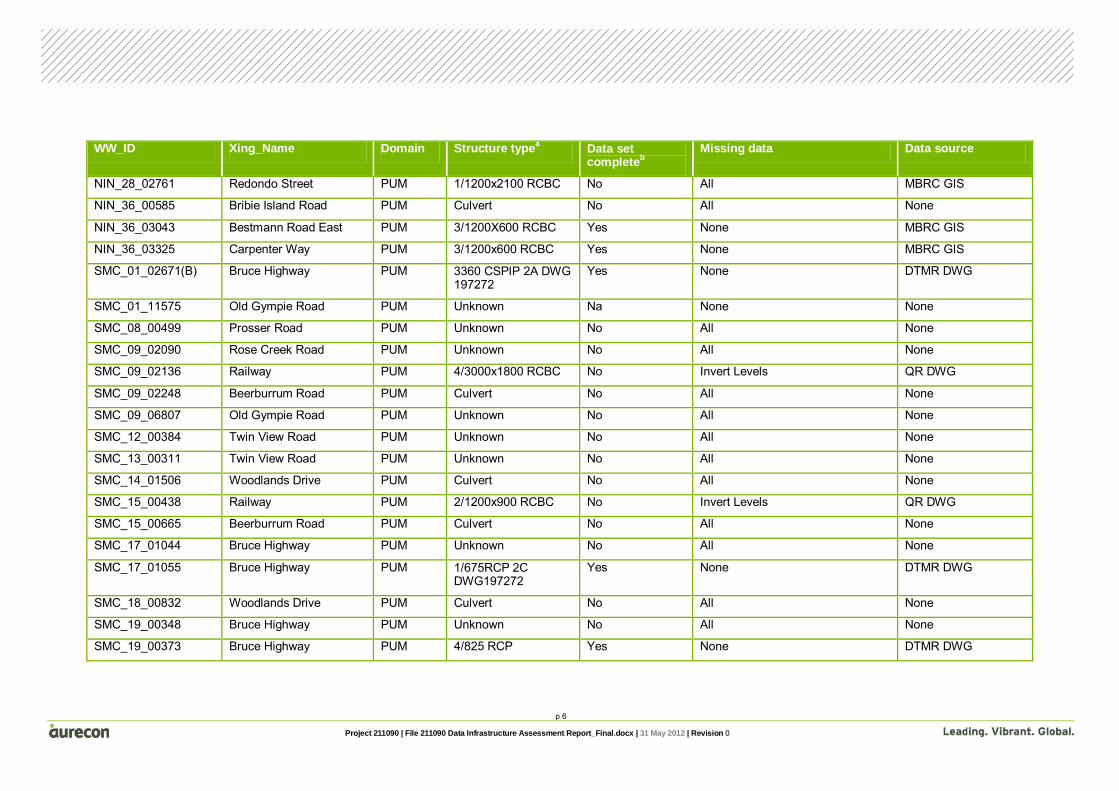
Appendix B – Data assessment and gap analysis
Pumicestone Passage – Bridges
WW_ID Xing_Name Domain Structure typea Data set completeb
Missing data Data source
BEE_01_01652 Bruce Highway PUM Bridge No Handrail DTMR DWG
BEE_01_01675 Bruce Highway PUM Bridge No Handrail DTMR DWG
BEE_01_06768 Railway PUM Bridge No Pier Data, Deck Elevation Data QR DWG
BEE_01_07615 Railway PUM Bridge No All None
BEE_01_07828 Beerburrum Road PUM Bridge Yes None DTMR DWG
BEE_10_01778 Beerburrum Road PUM Bridge No All None
ELI_01_09748 Donnybrook Road PUM Footbridge No All None
ELI_01_10536 Donnybrook Road PUM Bridge Yes None MBRC DWG
NIN_36_00225 Bribie Island Road PUM Footbridge No All None
SMC_01_02645 Bruce Highway PUM Bridge Yes None DTMR DWG
SMC_01_02671(A) Bruce Highway PUM Bridge Yes None DTMR DWG
SMC_01_05975 Railway PUM Bridge No Pier Data, Deck Vertical Data QR DWG
SMC_01_06873 Beerburrum Road PUM Bridge Yes None DTMR DWG
SMC_01_13518 Twin View Road PUM Bridge Yes None MBRC DWG
SMC_34_03784 King Road PUM Bridge No All None a Where data source is not available the structure type has been taken from aerial images and will need to be confirmed once data is available b Complete data set column refers to critical data as identified in Section 2 of the report

p 3
Project 211090 | File 211090 Data Infrastructure Assessment Report_Final.docx | 31 May 2012 | Revision 0
Pumicestone Passage – Culverts
WW_ID Xing_Name Domain Structure typea Data set completeb
Missing data Data source
BEE_01_11919 Old Gympie Road PUM Unknown No All None
BEE_06_00530 Railway PUM Culvert No All None
BEE_06_00568 Beerburrum Road PUM Unknown No All None
BEE_08_00425 Railway PUM 5/1800 RCP No Invert Levels QR DWG
BEE_08_00755 Railway PUM Culvert No All None
BEE_08_00787 Beerburrum Road PUM Unknown No All None
BEE_09_01117 Bruce Highway PUM Unknown No All None
BEE_09_01592 Steve Irwin Way PUM Culvert No Invert Levels QR DWG
BEE_10_01633 Railway PUM 6/2100 RCP No Invert Levels QR DWG
BEE_10_01724 Railway PUM Culvert No All None
BEE_12_00243 Bruce Highway PUM 1/1800 RCP Yes None DTMR DWG
BEE_12_00275 Bruce Highway PUM 1/1800 RCP Yes None DTMR DWG
BEE_14_00454 Bruce Highway PUM Unknown No All None
BEE_14_00481 Bruce Highway PUM Unknown No All None
BEE_16_00679 Bruce Highway PUM 1/1200x450 RCBC No All None
BEE_16_00703 Bruce Highway PUM 2/750 RCP Yes None DTMR DWG
BEE_18_01376 Bruce Highway PUM 3/1800X450 RCBC No All None
BEE_18_01396 Bruce Highway PUM 6/1800 RCP Yes None DTMR DWG
BEE_18_05085 Rose Creek Road PUM 2/1800 RCP No Invert Levels QR BWG
BEE_18_05085 Railway PUM Culvert Yes None MBRC GIS
BEE_18_05151 Railway PUM Culvert Yes None MBRC GIS

p 4
Project 211090 | File 211090 Data Infrastructure Assessment Report_Final.docx | 31 May 2012 | Revision 0
WW_ID Xing_Name Domain Structure typea Data set completeb
Missing data Data source
BEE_18_05190 Beerburrum Road PUM Culvert No All None
ELI_03_01693 Bruce Highway PUM Culvert No All None
ELI_07_00183 Meldale Road PUM 1/450 RCP Yes None MBRC GIS
ELI_09_00104 Meldale Road PUM 2/450 RCP Yes None MBRC GIS
ELI_10_00057 Pumicestone Road PUM Culvert No All None
ELI_11_04807 Donnybrook Road PUM Culvert No All None
Not on reach Pumicestone Road PUM 1/750x450 RCBC Yes None DTMR DWG
Not on reach Pumicestone Road PUM 1/900x300 RCBC Yes None DTMR DWG
Not on reach Pumicestone Road PUM 1/450 RCP Yes None DTMR DWG
Not on reach Pumicestone Road PUM 2/600x300 RCBC Yes None DTMR DWG
Not on reach Pumicestone Road PUM 2/600x300 RCBC Yes None DTMR DWG
ELI_13_01616 Donnybrook Road PUM Culvert No All None
ELI_14_00382 Pumicestone Road PUM Culvert No All None
ELI_16_01136 Pumicestone Road PUM Culvert No All None
ELI_18_00000 Esplanade PUM Unknown No All None
ELI_20_00000 Esplanade PUM 4/750 RCP Yes None MBRC GIS
ELI_20_00617 Freeman Road PUM 3/1200x600 RCBC Yes None MBRC GIS
ELI_22_00038 Esplanade PUM Culvert No All None
ELI_24_00122 Esplanade PUM Unknown No All None
GMC_01_15669 Bruce Highway PUM Unknown No All None
GMC_02_00459 Bruce Highway PUM Culvert No All None
GMC_04_02236 Bruce Highway PUM 1/750 RCP No All None
GMC_24_00212 Esplanade North PUM Culvert No All None

p 5
Project 211090 | File 211090 Data Infrastructure Assessment Report_Final.docx | 31 May 2012 | Revision 0
WW_ID Xing_Name Domain Structure typea Data set completeb
Missing data Data source
GMC_24_00331 Amy Street PUM 3/750 RCP Yes None MBRC GIS
GMC_26_00000 Amy Street PUM 2/1200x450 RCBC Yes None MBRC GIS
GMC_28_02630 Donnybrook Road PUM Unknown No All None
Not on reach Pumicestone Road PUM 1/450x300 RCBC No Location DTMR DWG
Not on reach Pumicestone Road PUM 1/450x300 RCBC No Location DTMR DWG
Not on reach Pumicestone Road PUM 1/450x300 RCBC No Location DTMR DWG
Not on reach Pumicestone Road PUM 1/450x300 RCBC No Location DTMR DWG
Not on reach Pumicestone Road PUM 1/450x300 RCBC Yes None DTMR DWG
Not on reach Pumicestone Road PUM 1/450x300 RCBC Yes None DTMR DWG
Not on reach Pumicestone Road PUM 1/450x300 RCBC Yes None DTMR DWG
NIN_01_18391 Pumicestone Road PUM Culvert No All None
NIN_01_23388 Rutters Road PUM Culvert No All None
NIN_01_23388 Bruce Highway PUM Culvert No All None
NIN_01_23388 Bruce Highway PUM Culvert No All None
NIN_14_00567 Minor Road PUM Unknown No All None
NIN_14_01586 Wattle Grove Drive PUM 1/750 RCP Yes None MBRC GIS
NIN_14_01586 Wrenaus Way PUM 3/750 RCP Yes None MBRC GIS
NIN_22_00733 Bribie Island Road PUM Culvert No All None
NIN_24_00716 Bribie Island Road PUM Culvert No All None
NIN_24_03255 Sandstone Bvd PUM Culvert No All None
NIN_28_00581 Sandheath Place PUM Culvert No All None
NIN_28_02308 Sandheath Place PUM 3/2400x1200 RCBC & 1/1200x1200 RCBC
No All MBRC GIS
p 6
Project 211090 | File 211090 Data Infrastructure Assessment Report_Final.docx | 31 May 2012 | Revision 0
WW_ID Xing_Name Domain Structure typea Data set completeb
Missing data Data source
NIN_28_02761 Redondo Street PUM 1/1200x2100 RCBC No All MBRC GIS
NIN_36_00585 Bribie Island Road PUM Culvert No All None
NIN_36_03043 Bestmann Road East PUM 3/1200X600 RCBC Yes None MBRC GIS
NIN_36_03325 Carpenter Way PUM 3/1200x600 RCBC Yes None MBRC GIS
SMC_01_02671(B) Bruce Highway PUM 3360 CSPIP 2A DWG 197272
Yes None DTMR DWG
SMC_01_11575 Old Gympie Road PUM Unknown Na None None
SMC_08_00499 Prosser Road PUM Unknown No All None
SMC_09_02090 Rose Creek Road PUM Unknown No All None
SMC_09_02136 Railway PUM 4/3000x1800 RCBC No Invert Levels QR DWG
SMC_09_02248 Beerburrum Road PUM Culvert No All None
SMC_09_06807 Old Gympie Road PUM Unknown No All None
SMC_12_00384 Twin View Road PUM Unknown No All None
SMC_13_00311 Twin View Road PUM Unknown No All None
SMC_14_01506 Woodlands Drive PUM Culvert No All None
SMC_15_00438 Railway PUM 2/1200x900 RCBC No Invert Levels QR DWG
SMC_15_00665 Beerburrum Road PUM Culvert No All None
SMC_17_01044 Bruce Highway PUM Unknown No All None
SMC_17_01055 Bruce Highway PUM 1/675RCP 2C DWG197272
Yes None DTMR DWG
SMC_18_00832 Woodlands Drive PUM Culvert No All None
SMC_19_00348 Bruce Highway PUM Unknown No All None
SMC_19_00373 Bruce Highway PUM 4/825 RCP Yes None DTMR DWG

p 7
Project 211090 | File 211090 Data Infrastructure Assessment Report_Final.docx | 31 May 2012 | Revision 0
WW_ID Xing_Name Domain Structure typea Data set completeb
Missing data Data source
SMC_20_01371 Williams Road PUM Unknown No All None
SMC_20_03707 Powell Road PUM Culvert No All None
SMC_20_03766 Hoffman Road PUM Unknown No All None
SMC_20_05638 Minor Road PUM Unknown No All None
SMC_22_00787 Newlands Road PUM Unknown No All None
SMC_24_00261 Newlands Road PUM Unknown No All None
SMC_26_00127 Powell Road PUM Culvert No All None
SMC_28_00908 Powell Road PUM Culvert No All None
SMC_28_01916 Scurr Road PUM Culvert No All None
SMC_28_02077 Scurr Road PUM Unknown No All None
SMC_30_00666 Scurr Road PUM 4/900 RCP Yes None MBRC DWG
SMC_36_00481 King Road PUM Unknown No All None
SMC_36_01650 Powell Road PUM Unknown No All None
SMC_40_00207 Powell Road PUM Unknown No All None
SMC_42_00788 Williams Road PUM Unknown No All None
SMC_42_01802 Pates Road PUM Culvert No All None
SMC_44_00868 Williams Road PUM Culvert No All None
SMC_46_01629 King Road PUM Unknown No All None
SMC_48_01569 King Road PUM Culvert No All None
SMC_58_00453 Hamilton Road PUM 9/675 RCP Yes None MBRC GIS
SMC_58_00504 Railway PUM 2/1800 RCP No Invert Levels QR DWG
SMC_58_00539 Beerburrum Road PUM Culvert No All None
SMC_60_00679 Kirrang Drive PUM 1/900 RCP Yes None MBRC GIS

p 8
Project 211090 | File 211090 Data Infrastructure Assessment Report_Final.docx | 31 May 2012 | Revision 0
WW_ID Xing_Name Domain Structure typea Data set completeb
Missing data Data source
SMC_64_01396 Mansfield Road PUM 1/1500x750 RCBC Yes None MBRC GIS
SMC_66_00151 Bigmor Drive PUM 1/450 RCP Yes None MBRC GIS
SMC_68_00227 Mansfield Road PUM 1/600 RCP Yes None MBRC GIS
SMC_70_00654 Mansfield Road PUM 3/900 RCP Yes None MBRC GIS
SMC_72_01331(A) Mansfield Road PUM 2/450 RCP Yes None MBRC GIS
SMC_72_01331(B) Mansfield Road PUM 1/450 RCP Yes None MBRC GIS a Where data source is not available the structure type has been taken from aerial images and will need to be confirmed once data is available b Complete data set column refers to critical data as identified in Section 2 of the report
Bribie Island – Bridges
WW_ID Xing_Name Domain Structure typea Data set completeb Missing data Data source
BON_01_00137 Welsby Parade BRI Bridge No All None
BON_01_00212 Footpath BRI Lock No All None
BON_01_00811 Goodwin Drive BRI Bridge No All None
BON_09_00050 Welsby Parade BRI Bridge No All None
BON_21_00037 South Esplanade BRI Bridge No All None
DUX_01_02462 Sunderland Drive BRI Bridge No All None
DUX_01_01826 Footpath BRI Footbridge No All None
DUX_02_00701 Eagles Landing BRI Bridge No All None
DUX_04_00568 Sunderland Drive BRI Bridge No All None
DUX_04_02128 Quarterdeck Drive BRI Bridge No All None
DUX_11_00000 Minor Road BRI Footbridge? No All None

p 9
Project 211090 | File 211090 Data Infrastructure Assessment Report_Final.docx | 31 May 2012 | Revision 0
WW_ID Xing_Name Domain Structure typea Data set completeb Missing data Data source
DUX_11_00000 Minor Road BRI Footbridge? No All None
DUX_12_00000 Island Parade BRI Bridge No All None
WRI_05_00000 Footpath BRI Footbridge No All None a Where data source is not available the structure type has been taken from aerial images and will need to be confirmed once data is available b Complete data set column refers to critical data as identified in Section 2 of the report
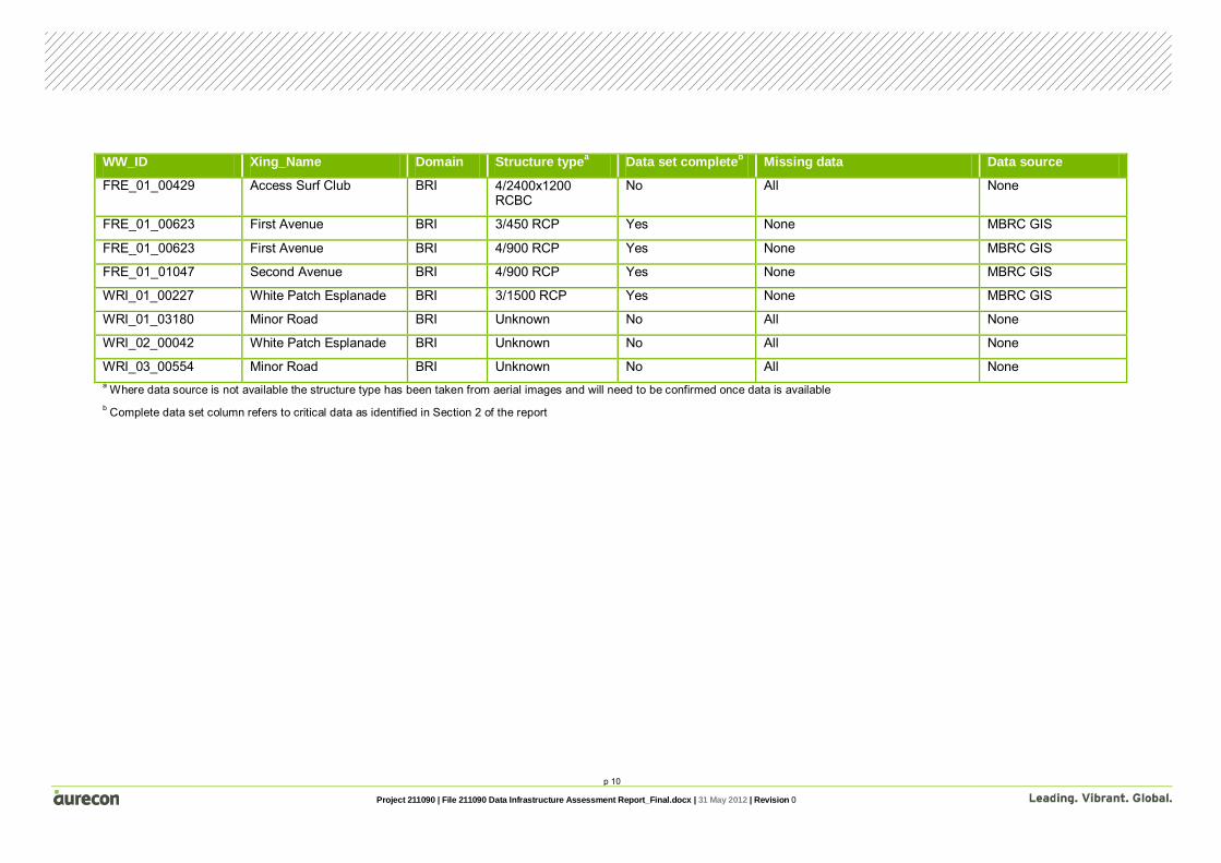
Bribie Island – Culverts
WW_ID Xing_Name Domain Structure typea Data set completeb Missing data Data source
BON_01_01940 Protea Drive BRI 2/1200 RCP Yes None MBRC GIS
BON_03_00000 Cotterill Avenue BRI 1/1200 RCP Yes None MBRC GIS
BON_09_00673 Goodwin Drive BRI 4/450 RCP Yes None MBRC GIS
BON_13_00238 Minor Road BRI Unknown No All None
BON_21_00612 Toorbul Street BRI 2/900x300 RCBC Yes None MBRC GIS
Not on reach Benabrow Avenue BRI 1/450 RCP Yes None MBRC GIS
Not on reach Benabrow Avenue BRI 1/1500X750 RCBC Yes None MBRC GIS
DUX_01_03276 Hornsby Road BRI Culvert No All None
DUX_06_00128 Endeavour Drive BRI 5/1500 RCP Yes None MBRC GIS
DUX_09_00546 Marina Boulevard BRI 3/1200x450 RCBC Yes None MBRC GIS
DUX_15_00000 Footpath BRI Unknown No All None
DUX_15_00148 Eucalypt Street BRI 1/900 RCP Yes None MBRC GIS
DUX_15_00148 Eucalypt Street BRI 1/900 RCP Yes None MBRC GIS
DUX_15_00148 Sylvan Beach Esplanade BRI 1/2400x1800 RCBC
Yes None MBRC GIS
p 10
Project 211090 | File 211090 Data Infrastructure Assessment Report_Final.docx | 31 May 2012 | Revision 0
WW_ID Xing_Name Domain Structure typea Data set completeb Missing data Data source
FRE_01_00429 Access Surf Club BRI 4/2400x1200 RCBC
No All None
FRE_01_00623 First Avenue BRI 3/450 RCP Yes None MBRC GIS
FRE_01_00623 First Avenue BRI 4/900 RCP Yes None MBRC GIS
FRE_01_01047 Second Avenue BRI 4/900 RCP Yes None MBRC GIS
WRI_01_00227 White Patch Esplanade BRI 3/1500 RCP Yes None MBRC GIS
WRI_01_03180 Minor Road BRI Unknown No All None
WRI_02_00042 White Patch Esplanade BRI Unknown No All None
WRI_03_00554 Minor Road BRI Unknown No All None a Where data source is not available the structure type has been taken from aerial images and will need to be confirmed once data is available b Complete data set column refers to critical data as identified in Section 2 of the report


Appendix C Structure prioritisation


Appendix C – Structure prioritisation
Pumicestone Passage – Structure Prioritisation
WW_ID Xing_Name Domain Land use Priority
BEE_01_01652 Bruce Highway PUM Rural A
BEE_01_01675 Bruce Highway PUM Rural A
BEE_01_06768 Railway PUM Rural A
BEE_01_07615 Railway PUM Rural A
BEE_01_07828 Beerburrum Road PUM Rural A
BEE_01_11919 Old Gympie Road PUM Rural B
BEE_06_00530 Railway PUM Rural B
BEE_06_00568 Beerburrum Road PUM Rural B
BEE_08_00425 Railway PUM Rural A
BEE_08_00755 Railway PUM Rural B
BEE_08_00787 Beerburrum Road PUM Rural B
BEE_09_01117 Bruce Highway PUM Rural A
BEE_09_01592 Steve Irwin Way PUM Rural B
BEE_10_01633 Railway PUM Rural A
BEE_10_01724 Railway PUM Rural A
BEE_10_01778 Beerburrum Road PUM Rural A
BEE_12_00243 Bruce Highway PUM Rural A
BEE_12_00275 Bruce Highway PUM Rural A
BEE_14_00454 Bruce Highway PUM Rural B
BEE_14_00481 Bruce Highway PUM Rural B
BEE_16_00679 Bruce Highway PUM Rural B
BEE_16_00703 Bruce Highway PUM Rural B
BEE_18_01376 Bruce Highway PUM Rural A
BEE_18_01396 Bruce Highway PUM Rural A
BEE_18_05085 Rose Creek Road PUM Rural B
BEE_18_05085 Railway PUM Rural A
BEE_18_05151 Railway PUM Rural A
BEE_18_05190 Beerburrum Road PUM Rural B
ELI_01_09748 Donnybrook Road PUM Rural B
ELI_01_10536 Donnybrook Road PUM Rural B
ELI_03_01693 Bruce Highway PUM Rural B
ELI_07_00183 Meldale Road PUM Rural B
ELI_09_00104 Meldale Road PUM Rural B
ELI_10_00057 Pumicestone Road PUM Rural B
ELI_11_04807 Donnybrook Road PUM Rural B
Not on reach Pumicestone Road PUM Rural B

WW_ID Xing_Name Domain Land use Priority
Not on reach Pumicestone Road PUM Rural B
Not on reach Pumicestone Road PUM Rural B
Not on reach Pumicestone Road PUM Rural B
Not on reach Pumicestone Road PUM Rural B
ELI_13_01616 Donnybrook Road PUM Rural B
ELI_14_00382 Pumicestone Road PUM Rural B
ELI_16_01136 Pumicestone Road PUM Rural B
ELI_18_00000 Esplanade PUM Urban A
ELI_20_00000 Esplanade PUM Urban A
ELI_20_00617 Freeman Road PUM Urban A
ELI_22_00038 Esplanade PUM Urban A
ELI_24_00122 Esplanade PUM Urban A
GMC_01_15669 Bruce Highway PUM Rural B
GMC_02_00459 Bruce Highway PUM Rural B
GMC_04_02236 Bruce Highway PUM Rural B
GMC_24_00212 Esplanade North PUM Urban A
GMC_24_00331 Amy Street PUM Urban A
GMC_26_00000 Amy Street PUM Urban A
GMC_28_02630 Donnybrook Road PUM Rural B
Not on reach Pumicestone Road PUM Rural B
Not on reach Pumicestone Road PUM Rural B
Not on reach Pumicestone Road PUM Rural B
Not on reach Pumicestone Road PUM Rural B
Not on reach Pumicestone Road PUM Rural B
Not on reach Pumicestone Road PUM Rural B
Not on reach Pumicestone Road PUM Rural B
NIN_01_18391 Pumicestone Road PUM Rural B
NIN_01_23388 Rutters Road PUM Rural B
NIN_01_23388 Bruce Highway PUM Rural B
NIN_01_23388 Bruce Highway PUM Rural B
NIN_14_00567 Minor Road PUM Urban A
NIN_14_01586 Wattle Grove Drive PUM Urban A
NIN_14_01586 Wrenaus Way PUM Urban A
NIN_22_00733 Bribie Island Road PUM Urban A
NIN_24_00716 Bribie Island Road PUM Urban A
NIN_24_03255 Sandstone Bvd PUM Urban A
NIN_28_00581 Sandheath Place PUM Urban A
NIN_28_02308 Sandheath Place PUM Urban A
NIN_28_02761 Redondo Street PUM Urban A

WW_ID Xing_Name Domain Land use Priority
NIN_36_00225 Bribie Island Road PUM Rural B
NIN_36_00585 Bribie Island Road PUM Rural B
NIN_36_03043 Bestmann Road East PUM Urban A
NIN_36_03325 Carpenter Way PUM Urban A
SMC_01_02645 Bruce Highway PUM Rural A
SMC_01_02671(A) Bruce Highway PUM Rural A
SMC_01_02671(B) Bruce Highway PUM Rural A
SMC_01_05975 Railway PUM Urban A
SMC_01_06873 Beerburrum Road PUM Urban A
SMC_01_11575 Old Gympie Road PUM Rural B
SMC_01_13518 Twin View Road PUM Rural B
SMC_08_00499 Prosser Road PUM Rural B
SMC_09_02090 Rose Creek Road PUM Rural B
SMC_09_02136 Railway PUM Rural A
SMC_09_02248 Beerburrum Road PUM Rural A
SMC_09_06807 Old Gympie Road PUM Rural B
SMC_12_00384 Twin View Road PUM Rural B
SMC_13_00311 Twin View Road PUM Rural B
SMC_14_01506 Woodlands Drive PUM Rural B
SMC_15_00438 Railway PUM Rural B
SMC_15_00665 Beerburrum Road PUM Urban A
SMC_17_01044 Bruce Highway PUM Rural B
SMC_17_01055 Bruce Highway PUM Rural B
SMC_18_00832 Woodlands Drive PUM Rural B
SMC_19_00348 Bruce Highway PUM Rural B
SMC_19_00373 Bruce Highway PUM Rural B
SMC_20_01371 Williams Road PUM Rural B
SMC_20_03707 Powell Road PUM Rural B
SMC_20_03766 Hoffman Road PUM Rural B
SMC_20_05638 Newlands Road PUM Rural B
SMC_22_00787 Newlands Road PUM Rural B
SMC_24_00261 Newlands Road PUM Rural B
SMC_26_00127 Powell Road PUM Rural B
SMC_28_00908 Powell Road PUM Rural B
SMC_28_01916 Scurr Road PUM Rural B
SMC_28_02077 Scurr Road PUM Rural B
SMC_30_00666 Scurr Road PUM Rural B
SMC_34_03784 King Road PUM Rural B
SMC_36_00481 King Road PUM Rural B

WW_ID Xing_Name Domain Land use Priority
SMC_36_01650 Powell Road PUM Rural B
SMC_40_00207 Powell Road PUM Rural B
SMC_42_00788 Williams Road PUM Rural B
SMC_42_01802 Pates Road PUM Rural B
SMC_44_00868 Williams Road PUM Rural B
SMC_46_01629 King Road PUM Rural B
SMC_48_01569 King Road PUM Rural B
SMC_58_00453 Hamilton Road PUM Rural B
SMC_58_00504 Railway PUM Rural A
SMC_58_00539 Beerburrum Road PUM Rural A
SMC_60_00679 Kirrang Drive PUM Urban A
SMC_64_01396 Mansfield Road PUM Urban A
SMC_66_00151 Bigmor Drive PUM Urban A
SMC_68_00227 Mansfield Road PUM Urban A
SMC_70_00654 Mansfield Road PUM Rural B
SMC_72_01331(A) Mansfield Road PUM Rural B
SMC_72_01331(B) Mansfield Road PUM Rural B
Bribie Island – Structure Prioritisation
WW_ID Xing_Name Domain Land use Priority
BON_01_00137 Welsby Parade BRI Urban A
BON_01_00212 Footpath BRI Urban A
BON_01_00811 Goodwin Drive BRI Urban A
BON_01_01940 Protea Drive BRI Urban A
BON_03_00000 Cotterill Avenue BRI Urban A
BON_09_00050 Welsby Parade BRI Urban A
BON_09_00673 Goodwin Drive BRI Urban A
BON_13_00238 Minor Road BRI Urban A
BON_21_00037 South Esplanade BRI Urban A
BON_21_00612 Toorbul Street BRI Urban A
DUX_01_02462 Sunderland Drive BRI Urban A
DUX_01_01826 Footpath BRI Urban A
Not on reach Benabrow Avenue BRI Urban A
Not on reach Benabrow Avenue BRI Urban A
DUX_01_03276 Hornsby Road BRI Urban A
DUX_02_00701 Eagles Landing BRI Urban A
DUX_04_00568 Sunderland Drive BRI Urban A
DUX_04_02128 Quarterdeck Drive BRI Urban A
DUX_06_00128 Endeavour Drive BRI Urban A

WW_ID Xing_Name Domain Land use Priority
DUX_09_00546 Marina Boulevard BRI Urban A
DUX_11_00000 Minor Road BRI Urban A
DUX_11_00000 Minor Road BRI Urban A
DUX_11_00000 Minor Road BRI Urban A
DUX_12_00000 Island Parade BRI Urban A
DUX_15_00000 Footpath BRI Urban A
DUX_15_00148 Eucalypt Street BRI Urban A
DUX_15_00148 Eucalypt Street BRI Urban A
DUX_15_00148 Sylvan Beach Esplanade BRI Urban A
FRE_01_00429 Access Surf Club BRI Urban A
FRE_01_00623 First Avenue BRI Urban A
FRE_01_00623 First Avenue BRI Urban A
FRE_01_01047 Second Avenue BRI Urban A
WRI_01_00227 White Patch Esplanade BRI Rural B
WRI_01_03180 Minor Road BRI Rural B
WRI_02_00042 White Patch Esplanade BRI Urban A
WRI_03_00554 Minor Road BRI Rural B
WRI_05_00000 Footpath BRI Urban A


Appendix D Bathymetric data assessment and gap analysis


Appendix D – Bathymetric data assessment and gap analysis
Pumicestone Passage – Bathymetric data gap analysis and prioritization
Reach Approximate Width Priority Data Available
ELI_01_00000 610 A No
ELI_01_00477 420 A No
ELI_01_01480 160 A No
ELI_01_02483 120 A No
ELI_01_03485 130 A No
ELI_01_03717 95 A No
ELI_01_04719 120 A No
ELI_01_05721 50 A No
ELI_01_06360 40 A No
ELI_01_06450 55 A No
ELI_01_07455 35 A No
ELI_01_07492 45 A No
ELI_01_08494 35 A No
ELI_01_09496 35 A No
ELI_01_09748 90 A No
ELI_01_10536 40 A No
ELI_01_11395 85 A No
ELI_01_12398 150 B No
ELI_01_12848 60 B No
ELI_01_13527 40 B No
ELI_01_14534 35 B No
ELI_01_15341 35 B No
ELI_01_15535 30 B No
ELI_01_16541 45 B No
ELI_01_17562 25 B No
ELI_01_18208 45 B No
ELI_01_18581 30 B No
ELI_01_19599 45 B No
ELI_01_20608 60 B No
ELI_11_00000 410 B No
ELI_11_00873 150 B No
ELI_11_01875 180 B No
ELI_11_02446 120 B No
ELI_12_00000 70 B No
ELI_15_00000 20 B No
GMC_01_00000 190 B No

Reach Approximate Width Priority Data Available
GMC_01_00319 190 B No
GMC_01_00604 140 B No
GMC_01_01320 420 B No
GMC_01_02323 490 B No
GMC_01_02719 250 B No
GMC_01_03325 280 B No
GMC_01_04327 180 B No
GMC_01_04695 160 B No
GMC_01_05586 30 B No
GMC_01_06379 20 B No
GMC_01_06600 20 B No
GMC_01_06792 25 B No
GMC_01_06969 20 B No
GMC_01_07726 10 B No
GMC_01_08734 10 B No
GMC_07_00000 5 B No
NIN_01_00000 180 A No
NIN_01_01000 180 A No
NIN_01_02001 210 A No
NIN_01_02695 90 A No
NIN_01_03762 120 A No
NIN_01_04195 120 A No
NIN_01_04346 130 A No
NIN_01_05009 150 A No
NIN_01_05871 60 A No
NIN_01_06010 60 A No
NIN_01_07014 30 A No
NIN_01_08016 30 A No
NIN_01_09018 15 A No
NIN_01_09575 15 A No
NIN_01_10020 15 A No
NIN_01_10052 15 A No
NIN_01_10735 10 B No
NIN_01_11367 10 B No
NIN_01_11737 10 B No
NIN_01_12891 10 B No
NIN_01_13893 10 B No
NIN_01_14016 10 B No
NIN_01_15043 10 B No

Reach Approximate Width Priority Data Available
NIN_01_16067 10 B No
NIN_01_16736 10 B No
NIN_01_17759 20 B No
NIN_01_18261 20 B No
NIN_01_18391 20 B No
NIN_01_19284 10 B No
NIN_03_00000 70 B No
NIN_03_01109 70 B No
NIN_34_00000 80 B No
NIN_34_00156 80 B No
NIN_36_00000 80 B No
NIN_36_00225 10 B No
SMC_01_00000 30 B Yes
SMC_01_00561 30 B Yes
SMC_01_01454 35 B Yes
SMC_01_01554 35 B Yes
SMC_01_02462 90 B Yes
SMC_01_02645 90 B Yes
SMC_01_02671 80 B Yes
SMC_01_03163 80 B Yes
SMC_01_03785 50 B Yes
SMC_01_04812 20 B Yes
SMC_01_04961 15 B Yes
SMC_01_05975 20 B Yes
SMC_01_06731 20 B Yes
SMC_01_06873 20 B Yes
SMC_09_00000 30 B Yes
SMC_09_00045 30 B Yes
SMC_58_00000 30 B Yes
SMC_64_00000 10 B Yes
SMC_64_00746 10 B Yes
SMC_64_00861 10 B Yes
SMC_64_01057 5 B Yes
SMC_64_01396 5 B Yes
Bribie Island – Bathymetric data gap analysis and prioritisation
Reach Approximate Width Priority Data Available
BON_01_00000 70 A Yes
BON_01_00137 70 A Yes
BON_01_00212 70 A Yes
BON_01_00664 70 A Yes
BON_01_00811 70 A Yes
BON_01_01701 70 A Yes
BON_01_01817 70 A Yes
BON_01_01940 70 A Yes
BON_02_00000 60 A Yes
BON_03_00000 50 A Yes
BON_05_00000 70 A Yes
BON_21_00037 10 B No
BON_21_00612 10 B No
DUX_01_00000 150 A Yes
DUX_01_00568 150 A Yes
DUX_01_00860 150 A Yes
DUX_01_01204 60 A Yes
DUX_01_01826 60 A Yes
DUX_02_00000 60 A Yes
DUX_02_00701 60 A Yes
DUX_04_00000 150 A Yes
DUX_04_00568 150 A Yes
DUX_04_00738 150 A Yes
DUX_04_00994 150 A Yes
DUX_04_01461 150 A Yes
DUX_04_02128 150 A Yes
DUX_06_00000 60 A Yes
DUX_06_00128 60 A Yes
DUX_07_00000 60 A Yes
DUX_08_00000 60 A Yes
DUX_09_00000 60 A Yes
DUX_10_00000 60 A Yes
DUX_11_00000 60 A Yes
DUX_12_00000 60 A Yes
DUX_15_00000 10 A No
DUX_15_00148 20 A No
FRE_06_01263 30 B No
FRE_06_01416 30 B No
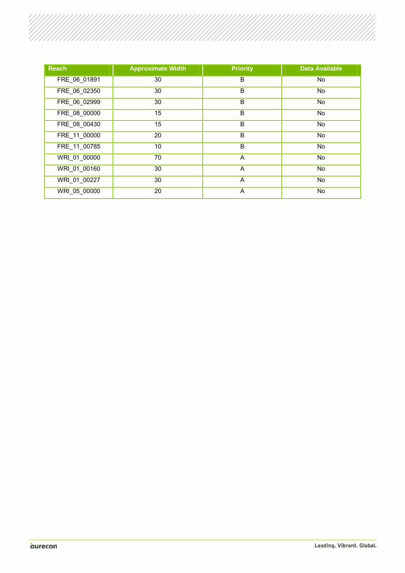
Reach Approximate Width Priority Data Available
FRE_06_01891 30 B No
FRE_06_02350 30 B No
FRE_06_02999 30 B No
FRE_08_00000 15 B No
FRE_08_00430 15 B No
FRE_11_00000 20 B No
FRE_11_00785 10 B No
WRI_01_00000 70 A No
WRI_01_00160 30 A No
WRI_01_00227 30 A No
WRI_05_00000 20 A No


Appendix E Survey requirements


Appendix E – Survey requirements
Bridge survey requirements
Priority A WW_ID Domain Xing_Name Priority A Survey
Required
BEE_01_01652 PUM Bruce Highway Handrail
BEE_01_01675 PUM Bruce Highway Handrail
BEE_01_06768 PUM Railway Pier Data, Deck Elevation Data
BEE_01_07615 PUM Railway All
BEE_10_01778 PUM Beerburrum Road All
SMC_01_05975 PUM Railway Pier Data, Deck Vertical Data
BON_01_00137 BRI Welsby Parade All
BON_01_00811 BRI Goodwin Drive All
BON_09_00050 BRI Welsby Parade All
BON_21_00037 BRI South Esplanade All
DUX_01_02462 BRI Sunderland Drive All
DUX_01_01826 BRI Footpath All
DUX_02_00701 BRI Eagles Landing All
DUX_04_00568 BRI Sunderland Drive All
DUX_04_02128 BRI Quarterdeck Drive All
DUX_11_00000 BRI Minor Road All
DUX_11_00000 BRI Minor Road All
DUX_12_00000 BRI Island Parade All
WRI_05_00000 BRI Footpath All
Priority B WW_ID Domain Xing_Name Priority B Survey
Required
ELI_01_09748 PUM Footbridge All
NIN_36_00225 PUM Footbridge All
SMC_34_03784 PUM Bridge All

Bathymetric survey requirements Priority A Survey Required Priority B Survey Required
ELI_01_00000 to ELI_11395 ELI_01_12398 to ELI_01_20608
NIN_01_00000 to NIN_01_10052 ELI_11_00000 to ELI_11_02446
DUX_15_00000 to DUX_15_00148 ELI_12_00000
WRI_01_00000 to WRI_01_00227 GMC_01_00000 to GMC_01_05586
NIN_01_10735 to NIN_01_19284
NIN_03_00000 to NIN_03_01109
NIN_34_00000 to NIN_34_00156
NIN_36_00000 to NIN_36_00225
BON_21_00037 to BON_21_00612

Appendix F Survey scope document


Project: RFD Stage 2 Detailed Modelling Reference: 211090-002
Project 211090-002 File Survey scope - infrastructure.doc 20 October 2010 /cw Page 1
To: Copy: Circulate: Name: Organisation: Location/Facsimile:
Paul Keating Aurecon
From: Talia Campbell Date: 20 October 2010 Total pages: 5
IMPORTANT NOTICE The information contained in this document is CONFIDENTIAL and may also be LEGALLY PRIVILEGED, intended only for the addressee. If you are not the addressee, you are hereby notified that any use or dissemination of the information and any copying of the document is strictly prohibited. If you are not the addressee, please immediately notify us by telephone and we will arrange for the return of this document to us.
Subject: Survey Scope - MBRC Infrastructure
Paul
As discussed, we are requesting a cost estimate to undertake survey of a number of different infrastructure types within the Moreton Bay Regional Council area. I�ve sought clarification from Council regarding which survey items are required and we would like quotes for the following two elements:
The bridge, detention basin, trunk drainage and bathymetric components outlined in Sections 1 to 2 of this document
A general cost per culvert and per bridge for other areas of Moreton Bay Regional Council, in particular the Stanley River and Mary River catchments shown in Figure 1
Can you please provide separate costs for the bridges and bathymetric components outlined below? Can you also provide separate costs for the Priority A and Priority B categories?
1. Bridges
Table 1 presents the general survey data requirements for the bridges. Table 2 and Figure 2 present the bridges for which survey is required.
Table 1 Survey Data Capture Requirements
Item Description Data Type
Width Decimals Domain/Remark
No of spans Number of bridge spans Integer 4 0
Length of spans1 Distance between pier centres Double 12 3
Deck point 1
Coordinate at corner of bridge deck � upstream, left hand side of deck when looking downstream Double 12 3
Deck level 1 Level at deck point 1 Double 12 3
Deck point 2
Coordinate at corner of bridge deck � upstream, right hand side of deck when looking downstream Double 12 3
Deck level 2 Level at deck point 2 Double 12 3
T +61 7 3173 8000 F +61 7 3173 8001 E [email protected] W aurecongroup.com
Aurecon Australia Pty Ltd ABN 54 005 139 873 32 Turbot Street (Locked Bag 331 Brisbane QLD 4001) Brisbane Queensland 4000 Australia
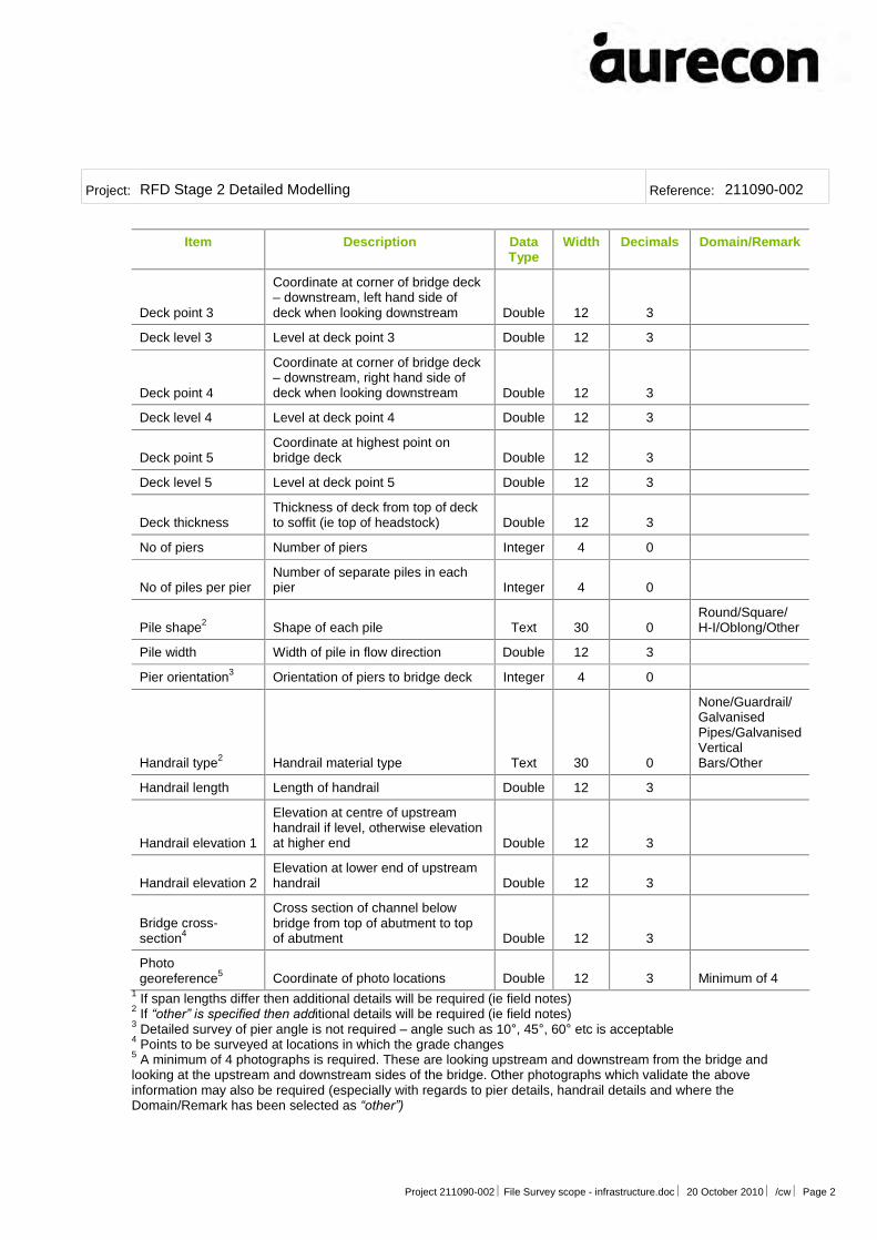
Project: RFD Stage 2 Detailed Modelling Reference: 211090-002
Project 211090-002 File Survey scope - infrastructure.doc 20 October 2010 /cw Page 2
Item Description Data Type
Width Decimals Domain/Remark
Deck point 3
Coordinate at corner of bridge deck � downstream, left hand side of deck when looking downstream Double 12 3
Deck level 3 Level at deck point 3 Double 12 3
Deck point 4
Coordinate at corner of bridge deck � downstream, right hand side of deck when looking downstream Double 12 3
Deck level 4 Level at deck point 4 Double 12 3
Deck point 5 Coordinate at highest point on bridge deck Double 12 3
Deck level 5 Level at deck point 5 Double 12 3
Deck thickness Thickness of deck from top of deck to soffit (ie top of headstock) Double 12 3
No of piers Number of piers Integer 4 0
No of piles per pier Number of separate piles in each pier Integer 4 0
Pile shape2 Shape of each pile Text 30 0 Round/Square/ H-I/Oblong/Other
Pile width Width of pile in flow direction Double 12 3
Pier orientation3 Orientation of piers to bridge deck Integer 4 0
Handrail type2 Handrail material type Text 30 0
None/Guardrail/Galvanised Pipes/Galvanised Vertical Bars/Other
Handrail length Length of handrail Double 12 3
Handrail elevation 1
Elevation at centre of upstream handrail if level, otherwise elevation at higher end Double 12 3
Handrail elevation 2 Elevation at lower end of upstream handrail Double 12 3
Bridge cross-section4
Cross section of channel below bridge from top of abutment to top of abutment Double 12 3
Photo georeference5 Coordinate of photo locations Double 12 3 Minimum of 4
1 If span lengths differ then additional details will be required (ie field notes) 2 If �other� is specified then additional details will be required (ie field notes) 3 Detailed survey of pier angle is not required � angle such as 10°, 45°, 60° etc is acceptable 4 Points to be surveyed at locations in which the grade changes
5 A minimum of 4 photographs is required. These are looking upstream and downstream from the bridge and looking at the upstream and downstream sides of the bridge. Other photographs which validate the above information may also be required (especially with regards to pier details, handrail details and where the Domain/Remark has been selected as �other�)
Project: RFD Stage 2 Detailed Modelling Reference: 211090-002
Project 211090-002 File Survey scope - infrastructure.doc 20 October 2010 /cw Page 3
Please note that:
All data is to be delivered in MGA coordinates with the origin of coordinates (PM number), coordinate values and estimated accuracy provided. Accuracy is to be 4th order or better
All heights are to be on AHD datum with origin datum supplied. Accuracy is to be 4th order or better
The data is to be supplied in ESRI shape file format GPS (RTK) methods are acceptable and will achieve the desired accuracies. Ensure there are
redundant checks to verify the accuracy Table 2 Survey Data Locations
Bridge ID Crossing Name Crossing Type Approx. Easting Approx. Northing
Priority A
BEE_01_01652 Bruce Highway Vehicle 497805 7013974
BEE_01_01675 Bruce Highway Vehicle 497782 7013975
BEE_01_06768 Railway Vehicle 495565 7016544
BEE_01_07615 Railway Vehicle 495302 7017144
BEE_10_01778 Beerburrum Road Vehicle 494894 7014900
SMC_01_05975 Railway Vehicle 494597 7012038
BON_01_00137 Welsby Parade Vehicle 515421 7005547
BON_01_00811 Goodwin Drive Vehicle 516056 7005739
BON_09_00050 Welsby Parade Vehicle 515677 7004747
BON_21_00037 South Esplanade Vehicle 515778 7003933
DUX_01_02462 Sunderland Drive Vehicle 515374 7006499
DUX_01_01826 Footpath Pedestrian 515439 7007366
DUX_02_00701 Eagles Landing Vehicle 515082 7008036
DUX_04_00568 Sunderland Drive Vehicle 513791 7008578
DUX_04_02128 Quarterdeck Drive Vehicle 514065 7009704
DUX_11_00000 Footbridge Pedestrian 513909 7007694
DUX_11_00000 Footbridge Pedestrian 513909 7007694
DUX_12_00000 Island Parade Vehicle 513968 7008859
WRI_05_00000 Footbridge Pedestrian 513238 7009480
Priority B
ELI_01_09748 Footbridge Pedestrian 503998 7010381
NIN_36_00225 Footbridge Pedestrian 512305 7006357
SMC_34_03784 Bridge Vehicle 490139 7011934
Project: RFD Stage 2 Detailed Modelling Reference: 211090-002
Project 211090-002 File Survey scope - infrastructure.doc 20 October 2010 /cw Page 4
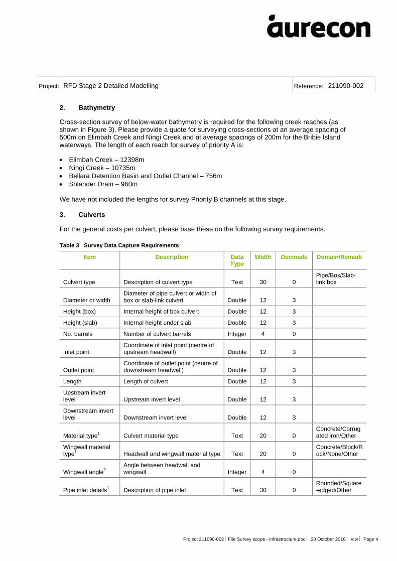
2. Bathymetry
Cross-section survey of below-water bathymetry is required for the following creek reaches (as shown in Figure 3). Please provide a quote for surveying cross-sections at an average spacing of 500m on Elimbah Creek and Ningi Creek and at average spacings of 200m for the Bribie Island waterways. The length of each reach for survey of priority A is:
Elimbah Creek � 12398m Ningi Creek � 10735m Bellara Detention Basin and Outlet Channel � 756m Solander Drain � 960m We have not included the lengths for survey Priority B channels at this stage. 3. Culverts
For the general costs per culvert, please base these on the following survey requirements.
Table 3 Survey Data Capture Requirements
Item Description Data Type
Width Decimals Domain/Remark
Culvert type Description of culvert type Text 30 0 Pipe/Box/Slab-link box
Diameter or width Diameter of pipe culvert or width of box or slab-link culvert Double 12 3
Height (box) Internal height of box culvert Double 12 3
Height (slab) Internal height under slab Double 12 3
No. barrels Number of culvert barrels Integer 4 0
Inlet point Coordinate of inlet point (centre of upstream headwall) Double 12 3
Outlet point Coordinate of outlet point (centre of downstream headwall) Double 12 3
Length Length of culvert Double 12 3
Upstream invert level Upstream invert level Double 12 3
Downstream invert level Downstream invert level Double 12 3
Material type1 Culvert material type Text 20 0 Concrete/Corrugated iron/Other
Wingwall material type1 Headwall and wingwall material type Text 20 0
Concrete/Block/Rock/None/Other
Wingwall angle2 Angle between headwall and wingwall Integer 4 0
Pipe inlet details1 Description of pipe inlet Text 30 0 Rounded/Square-edged/Other

Project: RFD Stage 2 Detailed Modelling Reference: 211090-002
Project 211090-002 File Survey scope - infrastructure.doc 20 October 2010 /cw Page 5
Item Description Data Type
Width Decimals Domain/Remark
Road elevation 1
RL at centre of structure on road crown if road is level; otherwise RL at higher end of structure on road crown if road has super-elevation Double 12 3
Road elevation 2
RL at lower end of structure on road crown if road not level if road has super-elevation; ignore otherwise Double 12 3
Handrail type1 Handrail material type Text 30 0
None/Guardrail/Galvanised Pipes/Galvanised Vertical Bars/Other
Handrail length Length of handrail Double 12 3
Handrail elevation 1
Elevation at centre of handrail if level, otherwise elevation at higher end Double 12 3
Handrail elevation 2 Elevation at lower end of handrail Double 12 3
Photo georeference3 Coordinate of photo locations Double 12 3 Minimum of 4
1 If �other� is specified then additional details will be required (ie field notes) 2 Detailed survey of wingwall angle is not required � angle such as 100°, 135°, 150° etc is acceptable. Note angle should be 0° if no wingwalls are present (ie if headwall only)
3 A minimum of 4 photographs is required. These are looking at the channel upstream and downstream of the culvert and looking at the upstream and downstream ends of culvert. Other photographs which validate the above information may also be required (especially with regards to headwall/wingwall setup, pipe inlet details, handrail details and where the Domain/Remark has been selected as �other�)
Please note that:
All data is to be delivered in MGA coordinates with the origin of coordinates (PM number), coordinate values and estimated accuracy provided. Accuracy is to be 4th order or better
All heights are to be on AHD datum with origin datum supplied. Accuracy is to be 4th order or better
The data is to be supplied in ESRI shape file or csv format GPS (RTK) methods are acceptable and will achieve the desired accuracies. Ensure there are
redundant checks to verify the accuracy
If you require any further information please let me know.
Regards
Talia Campbell Senior Engineer Water


RedcliffeRedcliffeRedcliffeRedcliffeRedcliffeRedcliffeRedcliffeRedcliffeRedcliffeRedcliffeRedcliffeRedcliffeRedcliffeRedcliffeRedcliffeRedcliffeRedcliffeRedcliffeRedcliffeRedcliffeRedcliffeRedcliffeRedcliffeRedcliffeRedcliffeRedcliffeRedcliffeRedcliffeRedcliffeRedcliffeRedcliffeRedcliffeRedcliffeRedcliffeRedcliffeRedcliffeRedcliffeRedcliffeRedcliffeRedcliffeRedcliffeRedcliffeRedcliffeRedcliffeRedcliffeRedcliffeRedcliffeRedcliffeRedcliffe
Burpengary CreekBurpengary CreekBurpengary CreekBurpengary CreekBurpengary CreekBurpengary CreekBurpengary CreekBurpengary CreekBurpengary CreekBurpengary CreekBurpengary CreekBurpengary CreekBurpengary CreekBurpengary CreekBurpengary CreekBurpengary CreekBurpengary CreekBurpengary CreekBurpengary CreekBurpengary CreekBurpengary CreekBurpengary CreekBurpengary CreekBurpengary CreekBurpengary CreekBurpengary CreekBurpengary CreekBurpengary CreekBurpengary CreekBurpengary CreekBurpengary CreekBurpengary CreekBurpengary CreekBurpengary CreekBurpengary CreekBurpengary CreekBurpengary CreekBurpengary CreekBurpengary CreekBurpengary CreekBurpengary CreekBurpengary CreekBurpengary CreekBurpengary CreekBurpengary CreekBurpengary CreekBurpengary CreekBurpengary CreekBurpengary Creek
Sidling CreekSidling CreekSidling CreekSidling CreekSidling CreekSidling CreekSidling CreekSidling CreekSidling CreekSidling CreekSidling CreekSidling CreekSidling CreekSidling CreekSidling CreekSidling CreekSidling CreekSidling CreekSidling CreekSidling CreekSidling CreekSidling CreekSidling CreekSidling CreekSidling CreekSidling CreekSidling CreekSidling CreekSidling CreekSidling CreekSidling CreekSidling CreekSidling CreekSidling CreekSidling CreekSidling CreekSidling CreekSidling CreekSidling CreekSidling CreekSidling CreekSidling CreekSidling CreekSidling CreekSidling CreekSidling CreekSidling CreekSidling CreekSidling Creek
Bribie IslandBribie IslandBribie IslandBribie IslandBribie IslandBribie IslandBribie IslandBribie IslandBribie IslandBribie IslandBribie IslandBribie IslandBribie IslandBribie IslandBribie IslandBribie IslandBribie IslandBribie IslandBribie IslandBribie IslandBribie IslandBribie IslandBribie IslandBribie IslandBribie IslandBribie IslandBribie IslandBribie IslandBribie IslandBribie IslandBribie IslandBribie IslandBribie IslandBribie IslandBribie IslandBribie IslandBribie IslandBribie IslandBribie IslandBribie IslandBribie IslandBribie IslandBribie IslandBribie IslandBribie IslandBribie IslandBribie IslandBribie IslandBribie Island
Upper Pine RiverUpper Pine RiverUpper Pine RiverUpper Pine RiverUpper Pine RiverUpper Pine RiverUpper Pine RiverUpper Pine RiverUpper Pine RiverUpper Pine RiverUpper Pine RiverUpper Pine RiverUpper Pine RiverUpper Pine RiverUpper Pine RiverUpper Pine RiverUpper Pine RiverUpper Pine RiverUpper Pine RiverUpper Pine RiverUpper Pine RiverUpper Pine RiverUpper Pine RiverUpper Pine RiverUpper Pine RiverUpper Pine RiverUpper Pine RiverUpper Pine RiverUpper Pine RiverUpper Pine RiverUpper Pine RiverUpper Pine RiverUpper Pine RiverUpper Pine RiverUpper Pine RiverUpper Pine RiverUpper Pine RiverUpper Pine RiverUpper Pine RiverUpper Pine RiverUpper Pine RiverUpper Pine RiverUpper Pine RiverUpper Pine RiverUpper Pine RiverUpper Pine RiverUpper Pine RiverUpper Pine RiverUpper Pine River
WOODFORDWOODFORDWOODFORDWOODFORDWOODFORDWOODFORDWOODFORDWOODFORDWOODFORDWOODFORDWOODFORDWOODFORDWOODFORDWOODFORDWOODFORDWOODFORDWOODFORDWOODFORDWOODFORDWOODFORDWOODFORDWOODFORDWOODFORDWOODFORDWOODFORDWOODFORDWOODFORDWOODFORDWOODFORDWOODFORDWOODFORDWOODFORDWOODFORDWOODFORDWOODFORDWOODFORDWOODFORDWOODFORDWOODFORDWOODFORDWOODFORDWOODFORDWOODFORDWOODFORDWOODFORDWOODFORDWOODFORDWOODFORDWOODFORD
GLASS HOUSE MOUNTAINSGLASS HOUSE MOUNTAINSGLASS HOUSE MOUNTAINSGLASS HOUSE MOUNTAINSGLASS HOUSE MOUNTAINSGLASS HOUSE MOUNTAINSGLASS HOUSE MOUNTAINSGLASS HOUSE MOUNTAINSGLASS HOUSE MOUNTAINSGLASS HOUSE MOUNTAINSGLASS HOUSE MOUNTAINSGLASS HOUSE MOUNTAINSGLASS HOUSE MOUNTAINSGLASS HOUSE MOUNTAINSGLASS HOUSE MOUNTAINSGLASS HOUSE MOUNTAINSGLASS HOUSE MOUNTAINSGLASS HOUSE MOUNTAINSGLASS HOUSE MOUNTAINSGLASS HOUSE MOUNTAINSGLASS HOUSE MOUNTAINSGLASS HOUSE MOUNTAINSGLASS HOUSE MOUNTAINSGLASS HOUSE MOUNTAINSGLASS HOUSE MOUNTAINSGLASS HOUSE MOUNTAINSGLASS HOUSE MOUNTAINSGLASS HOUSE MOUNTAINSGLASS HOUSE MOUNTAINSGLASS HOUSE MOUNTAINSGLASS HOUSE MOUNTAINSGLASS HOUSE MOUNTAINSGLASS HOUSE MOUNTAINSGLASS HOUSE MOUNTAINSGLASS HOUSE MOUNTAINSGLASS HOUSE MOUNTAINSGLASS HOUSE MOUNTAINSGLASS HOUSE MOUNTAINSGLASS HOUSE MOUNTAINSGLASS HOUSE MOUNTAINSGLASS HOUSE MOUNTAINSGLASS HOUSE MOUNTAINSGLASS HOUSE MOUNTAINSGLASS HOUSE MOUNTAINSGLASS HOUSE MOUNTAINSGLASS HOUSE MOUNTAINSGLASS HOUSE MOUNTAINSGLASS HOUSE MOUNTAINSGLASS HOUSE MOUNTAINS
MALENYMALENYMALENYMALENYMALENYMALENYMALENYMALENYMALENYMALENYMALENYMALENYMALENYMALENYMALENYMALENYMALENYMALENYMALENYMALENYMALENYMALENYMALENYMALENYMALENYMALENYMALENYMALENYMALENYMALENYMALENYMALENYMALENYMALENYMALENYMALENYMALENYMALENYMALENYMALENYMALENYMALENYMALENYMALENYMALENYMALENYMALENYMALENYMALENY MOOLOOLAHMOOLOOLAHMOOLOOLAHMOOLOOLAHMOOLOOLAHMOOLOOLAHMOOLOOLAHMOOLOOLAHMOOLOOLAHMOOLOOLAHMOOLOOLAHMOOLOOLAHMOOLOOLAHMOOLOOLAHMOOLOOLAHMOOLOOLAHMOOLOOLAHMOOLOOLAHMOOLOOLAHMOOLOOLAHMOOLOOLAHMOOLOOLAHMOOLOOLAHMOOLOOLAHMOOLOOLAHMOOLOOLAHMOOLOOLAHMOOLOOLAHMOOLOOLAHMOOLOOLAHMOOLOOLAHMOOLOOLAHMOOLOOLAHMOOLOOLAHMOOLOOLAHMOOLOOLAHMOOLOOLAHMOOLOOLAHMOOLOOLAHMOOLOOLAHMOOLOOLAHMOOLOOLAHMOOLOOLAHMOOLOOLAHMOOLOOLAHMOOLOOLAHMOOLOOLAHMOOLOOLAHMOOLOOLAH
LANDSBOROUGHLANDSBOROUGHLANDSBOROUGHLANDSBOROUGHLANDSBOROUGHLANDSBOROUGHLANDSBOROUGHLANDSBOROUGHLANDSBOROUGHLANDSBOROUGHLANDSBOROUGHLANDSBOROUGHLANDSBOROUGHLANDSBOROUGHLANDSBOROUGHLANDSBOROUGHLANDSBOROUGHLANDSBOROUGHLANDSBOROUGHLANDSBOROUGHLANDSBOROUGHLANDSBOROUGHLANDSBOROUGHLANDSBOROUGHLANDSBOROUGHLANDSBOROUGHLANDSBOROUGHLANDSBOROUGHLANDSBOROUGHLANDSBOROUGHLANDSBOROUGHLANDSBOROUGHLANDSBOROUGHLANDSBOROUGHLANDSBOROUGHLANDSBOROUGHLANDSBOROUGHLANDSBOROUGHLANDSBOROUGHLANDSBOROUGHLANDSBOROUGHLANDSBOROUGHLANDSBOROUGHLANDSBOROUGHLANDSBOROUGHLANDSBOROUGHLANDSBOROUGHLANDSBOROUGHLANDSBOROUGH
PEACHESTERPEACHESTERPEACHESTERPEACHESTERPEACHESTERPEACHESTERPEACHESTERPEACHESTERPEACHESTERPEACHESTERPEACHESTERPEACHESTERPEACHESTERPEACHESTERPEACHESTERPEACHESTERPEACHESTERPEACHESTERPEACHESTERPEACHESTERPEACHESTERPEACHESTERPEACHESTERPEACHESTERPEACHESTERPEACHESTERPEACHESTERPEACHESTERPEACHESTERPEACHESTERPEACHESTERPEACHESTERPEACHESTERPEACHESTERPEACHESTERPEACHESTERPEACHESTERPEACHESTERPEACHESTERPEACHESTERPEACHESTERPEACHESTERPEACHESTERPEACHESTERPEACHESTERPEACHESTERPEACHESTERPEACHESTERPEACHESTERBEERWAHBEERWAHBEERWAHBEERWAHBEERWAHBEERWAHBEERWAHBEERWAHBEERWAHBEERWAHBEERWAHBEERWAHBEERWAHBEERWAHBEERWAHBEERWAHBEERWAHBEERWAHBEERWAHBEERWAHBEERWAHBEERWAHBEERWAHBEERWAHBEERWAHBEERWAHBEERWAHBEERWAHBEERWAHBEERWAHBEERWAHBEERWAHBEERWAHBEERWAHBEERWAHBEERWAHBEERWAHBEERWAHBEERWAHBEERWAHBEERWAHBEERWAHBEERWAHBEERWAHBEERWAHBEERWAHBEERWAHBEERWAHBEERWAH
MOUNT NEBOMOUNT NEBOMOUNT NEBOMOUNT NEBOMOUNT NEBOMOUNT NEBOMOUNT NEBOMOUNT NEBOMOUNT NEBOMOUNT NEBOMOUNT NEBOMOUNT NEBOMOUNT NEBOMOUNT NEBOMOUNT NEBOMOUNT NEBOMOUNT NEBOMOUNT NEBOMOUNT NEBOMOUNT NEBOMOUNT NEBOMOUNT NEBOMOUNT NEBOMOUNT NEBOMOUNT NEBOMOUNT NEBOMOUNT NEBOMOUNT NEBOMOUNT NEBOMOUNT NEBOMOUNT NEBOMOUNT NEBOMOUNT NEBOMOUNT NEBOMOUNT NEBOMOUNT NEBOMOUNT NEBOMOUNT NEBOMOUNT NEBOMOUNT NEBOMOUNT NEBOMOUNT NEBOMOUNT NEBOMOUNT NEBOMOUNT NEBOMOUNT NEBOMOUNT NEBOMOUNT NEBOMOUNT NEBO
DAYBORODAYBORODAYBORODAYBORODAYBORODAYBORODAYBORODAYBORODAYBORODAYBORODAYBORODAYBORODAYBORODAYBORODAYBORODAYBORODAYBORODAYBORODAYBORODAYBORODAYBORODAYBORODAYBORODAYBORODAYBORODAYBORODAYBORODAYBORODAYBORODAYBORODAYBORODAYBORODAYBORODAYBORODAYBORODAYBORODAYBORODAYBORODAYBORODAYBORODAYBORODAYBORODAYBORODAYBORODAYBORODAYBORODAYBORODAYBORODAYBORO
WAMURANWAMURANWAMURANWAMURANWAMURANWAMURANWAMURANWAMURANWAMURANWAMURANWAMURANWAMURANWAMURANWAMURANWAMURANWAMURANWAMURANWAMURANWAMURANWAMURANWAMURANWAMURANWAMURANWAMURANWAMURANWAMURANWAMURANWAMURANWAMURANWAMURANWAMURANWAMURANWAMURANWAMURANWAMURANWAMURANWAMURANWAMURANWAMURANWAMURANWAMURANWAMURANWAMURANWAMURANWAMURANWAMURANWAMURANWAMURANWAMURAN
SAMFORDSAMFORDSAMFORDSAMFORDSAMFORDSAMFORDSAMFORDSAMFORDSAMFORDSAMFORDSAMFORDSAMFORDSAMFORDSAMFORDSAMFORDSAMFORDSAMFORDSAMFORDSAMFORDSAMFORDSAMFORDSAMFORDSAMFORDSAMFORDSAMFORDSAMFORDSAMFORDSAMFORDSAMFORDSAMFORDSAMFORDSAMFORDSAMFORDSAMFORDSAMFORDSAMFORDSAMFORDSAMFORDSAMFORDSAMFORDSAMFORDSAMFORDSAMFORDSAMFORDSAMFORDSAMFORDSAMFORDSAMFORDSAMFORD
NARANGBANARANGBANARANGBANARANGBANARANGBANARANGBANARANGBANARANGBANARANGBANARANGBANARANGBANARANGBANARANGBANARANGBANARANGBANARANGBANARANGBANARANGBANARANGBANARANGBANARANGBANARANGBANARANGBANARANGBANARANGBANARANGBANARANGBANARANGBANARANGBANARANGBANARANGBANARANGBANARANGBANARANGBANARANGBANARANGBANARANGBANARANGBANARANGBANARANGBANARANGBANARANGBANARANGBANARANGBANARANGBANARANGBANARANGBANARANGBANARANGBA
MORAYFIELDMORAYFIELDMORAYFIELDMORAYFIELDMORAYFIELDMORAYFIELDMORAYFIELDMORAYFIELDMORAYFIELDMORAYFIELDMORAYFIELDMORAYFIELDMORAYFIELDMORAYFIELDMORAYFIELDMORAYFIELDMORAYFIELDMORAYFIELDMORAYFIELDMORAYFIELDMORAYFIELDMORAYFIELDMORAYFIELDMORAYFIELDMORAYFIELDMORAYFIELDMORAYFIELDMORAYFIELDMORAYFIELDMORAYFIELDMORAYFIELDMORAYFIELDMORAYFIELDMORAYFIELDMORAYFIELDMORAYFIELDMORAYFIELDMORAYFIELDMORAYFIELDMORAYFIELDMORAYFIELDMORAYFIELDMORAYFIELDMORAYFIELDMORAYFIELDMORAYFIELDMORAYFIELDMORAYFIELDMORAYFIELD
CABOOLTURECABOOLTURECABOOLTURECABOOLTURECABOOLTURECABOOLTURECABOOLTURECABOOLTURECABOOLTURECABOOLTURECABOOLTURECABOOLTURECABOOLTURECABOOLTURECABOOLTURECABOOLTURECABOOLTURECABOOLTURECABOOLTURECABOOLTURECABOOLTURECABOOLTURECABOOLTURECABOOLTURECABOOLTURECABOOLTURECABOOLTURECABOOLTURECABOOLTURECABOOLTURECABOOLTURECABOOLTURECABOOLTURECABOOLTURECABOOLTURECABOOLTURECABOOLTURECABOOLTURECABOOLTURECABOOLTURECABOOLTURECABOOLTURECABOOLTURECABOOLTURECABOOLTURECABOOLTURECABOOLTURECABOOLTURECABOOLTURE SANDSTONE POINTSANDSTONE POINTSANDSTONE POINTSANDSTONE POINTSANDSTONE POINTSANDSTONE POINTSANDSTONE POINTSANDSTONE POINTSANDSTONE POINTSANDSTONE POINTSANDSTONE POINTSANDSTONE POINTSANDSTONE POINTSANDSTONE POINTSANDSTONE POINTSANDSTONE POINTSANDSTONE POINTSANDSTONE POINTSANDSTONE POINTSANDSTONE POINTSANDSTONE POINTSANDSTONE POINTSANDSTONE POINTSANDSTONE POINTSANDSTONE POINTSANDSTONE POINTSANDSTONE POINTSANDSTONE POINTSANDSTONE POINTSANDSTONE POINTSANDSTONE POINTSANDSTONE POINTSANDSTONE POINTSANDSTONE POINTSANDSTONE POINTSANDSTONE POINTSANDSTONE POINTSANDSTONE POINTSANDSTONE POINTSANDSTONE POINTSANDSTONE POINTSANDSTONE POINTSANDSTONE POINTSANDSTONE POINTSANDSTONE POINTSANDSTONE POINTSANDSTONE POINTSANDSTONE POINTSANDSTONE POINT
BEACHMEREBEACHMEREBEACHMEREBEACHMEREBEACHMEREBEACHMEREBEACHMEREBEACHMEREBEACHMEREBEACHMEREBEACHMEREBEACHMEREBEACHMEREBEACHMEREBEACHMEREBEACHMEREBEACHMEREBEACHMEREBEACHMEREBEACHMEREBEACHMEREBEACHMEREBEACHMEREBEACHMEREBEACHMEREBEACHMEREBEACHMEREBEACHMEREBEACHMEREBEACHMEREBEACHMEREBEACHMEREBEACHMEREBEACHMEREBEACHMEREBEACHMEREBEACHMEREBEACHMEREBEACHMEREBEACHMEREBEACHMEREBEACHMEREBEACHMEREBEACHMEREBEACHMEREBEACHMEREBEACHMEREBEACHMEREBEACHMERE
NINGININGININGININGININGININGININGININGININGININGININGININGININGININGININGININGININGININGININGININGININGININGININGININGININGININGININGININGININGININGININGININGININGININGININGININGININGININGININGININGININGININGININGININGININGININGININGININGININGI
TOORBULTOORBULTOORBULTOORBULTOORBULTOORBULTOORBULTOORBULTOORBULTOORBULTOORBULTOORBULTOORBULTOORBULTOORBULTOORBULTOORBULTOORBULTOORBULTOORBULTOORBULTOORBULTOORBULTOORBULTOORBULTOORBULTOORBULTOORBULTOORBULTOORBULTOORBULTOORBULTOORBULTOORBULTOORBULTOORBULTOORBULTOORBULTOORBULTOORBULTOORBULTOORBULTOORBULTOORBULTOORBULTOORBULTOORBULTOORBULTOORBUL
RedcliffeRedcliffeRedcliffeRedcliffeRedcliffeRedcliffeRedcliffeRedcliffeRedcliffeRedcliffeRedcliffeRedcliffeRedcliffeRedcliffeRedcliffeRedcliffeRedcliffeRedcliffeRedcliffeRedcliffeRedcliffeRedcliffeRedcliffeRedcliffeRedcliffeRedcliffeRedcliffeRedcliffeRedcliffeRedcliffeRedcliffeRedcliffeRedcliffeRedcliffeRedcliffeRedcliffeRedcliffeRedcliffeRedcliffeRedcliffeRedcliffeRedcliffeRedcliffeRedcliffeRedcliffeRedcliffeRedcliffeRedcliffeRedcliffe
Burpengary CreekBurpengary CreekBurpengary CreekBurpengary CreekBurpengary CreekBurpengary CreekBurpengary CreekBurpengary CreekBurpengary CreekBurpengary CreekBurpengary CreekBurpengary CreekBurpengary CreekBurpengary CreekBurpengary CreekBurpengary CreekBurpengary CreekBurpengary CreekBurpengary CreekBurpengary CreekBurpengary CreekBurpengary CreekBurpengary CreekBurpengary CreekBurpengary CreekBurpengary CreekBurpengary CreekBurpengary CreekBurpengary CreekBurpengary CreekBurpengary CreekBurpengary CreekBurpengary CreekBurpengary CreekBurpengary CreekBurpengary CreekBurpengary CreekBurpengary CreekBurpengary CreekBurpengary CreekBurpengary CreekBurpengary CreekBurpengary CreekBurpengary CreekBurpengary CreekBurpengary CreekBurpengary CreekBurpengary CreekBurpengary Creek
Sidling CreekSidling CreekSidling CreekSidling CreekSidling CreekSidling CreekSidling CreekSidling CreekSidling CreekSidling CreekSidling CreekSidling CreekSidling CreekSidling CreekSidling CreekSidling CreekSidling CreekSidling CreekSidling CreekSidling CreekSidling CreekSidling CreekSidling CreekSidling CreekSidling CreekSidling CreekSidling CreekSidling CreekSidling CreekSidling CreekSidling CreekSidling CreekSidling CreekSidling CreekSidling CreekSidling CreekSidling CreekSidling CreekSidling CreekSidling CreekSidling CreekSidling CreekSidling CreekSidling CreekSidling CreekSidling CreekSidling CreekSidling CreekSidling Creek
Bribie IslandBribie IslandBribie IslandBribie IslandBribie IslandBribie IslandBribie IslandBribie IslandBribie IslandBribie IslandBribie IslandBribie IslandBribie IslandBribie IslandBribie IslandBribie IslandBribie IslandBribie IslandBribie IslandBribie IslandBribie IslandBribie IslandBribie IslandBribie IslandBribie IslandBribie IslandBribie IslandBribie IslandBribie IslandBribie IslandBribie IslandBribie IslandBribie IslandBribie IslandBribie IslandBribie IslandBribie IslandBribie IslandBribie IslandBribie IslandBribie IslandBribie IslandBribie IslandBribie IslandBribie IslandBribie IslandBribie IslandBribie IslandBribie Island
Upper Pine RiverUpper Pine RiverUpper Pine RiverUpper Pine RiverUpper Pine RiverUpper Pine RiverUpper Pine RiverUpper Pine RiverUpper Pine RiverUpper Pine RiverUpper Pine RiverUpper Pine RiverUpper Pine RiverUpper Pine RiverUpper Pine RiverUpper Pine RiverUpper Pine RiverUpper Pine RiverUpper Pine RiverUpper Pine RiverUpper Pine RiverUpper Pine RiverUpper Pine RiverUpper Pine RiverUpper Pine RiverUpper Pine RiverUpper Pine RiverUpper Pine RiverUpper Pine RiverUpper Pine RiverUpper Pine RiverUpper Pine RiverUpper Pine RiverUpper Pine RiverUpper Pine RiverUpper Pine RiverUpper Pine RiverUpper Pine RiverUpper Pine RiverUpper Pine RiverUpper Pine RiverUpper Pine RiverUpper Pine RiverUpper Pine RiverUpper Pine RiverUpper Pine RiverUpper Pine RiverUpper Pine RiverUpper Pine River Hays InletHays InletHays InletHays InletHays InletHays InletHays InletHays InletHays InletHays InletHays InletHays InletHays InletHays InletHays InletHays InletHays InletHays InletHays InletHays InletHays InletHays InletHays InletHays InletHays InletHays InletHays InletHays InletHays InletHays InletHays InletHays InletHays InletHays InletHays InletHays InletHays InletHays InletHays InletHays InletHays InletHays InletHays InletHays InletHays InletHays InletHays InletHays InletHays Inlet
Lower Pine RiverLower Pine RiverLower Pine RiverLower Pine RiverLower Pine RiverLower Pine RiverLower Pine RiverLower Pine RiverLower Pine RiverLower Pine RiverLower Pine RiverLower Pine RiverLower Pine RiverLower Pine RiverLower Pine RiverLower Pine RiverLower Pine RiverLower Pine RiverLower Pine RiverLower Pine RiverLower Pine RiverLower Pine RiverLower Pine RiverLower Pine RiverLower Pine RiverLower Pine RiverLower Pine RiverLower Pine RiverLower Pine RiverLower Pine RiverLower Pine RiverLower Pine RiverLower Pine RiverLower Pine RiverLower Pine RiverLower Pine RiverLower Pine RiverLower Pine RiverLower Pine RiverLower Pine RiverLower Pine RiverLower Pine RiverLower Pine RiverLower Pine RiverLower Pine RiverLower Pine RiverLower Pine RiverLower Pine RiverLower Pine River
Brisbane CoastalBrisbane CoastalBrisbane CoastalBrisbane CoastalBrisbane CoastalBrisbane CoastalBrisbane CoastalBrisbane CoastalBrisbane CoastalBrisbane CoastalBrisbane CoastalBrisbane CoastalBrisbane CoastalBrisbane CoastalBrisbane CoastalBrisbane CoastalBrisbane CoastalBrisbane CoastalBrisbane CoastalBrisbane CoastalBrisbane CoastalBrisbane CoastalBrisbane CoastalBrisbane CoastalBrisbane CoastalBrisbane CoastalBrisbane CoastalBrisbane CoastalBrisbane CoastalBrisbane CoastalBrisbane CoastalBrisbane CoastalBrisbane CoastalBrisbane CoastalBrisbane CoastalBrisbane CoastalBrisbane CoastalBrisbane CoastalBrisbane CoastalBrisbane CoastalBrisbane CoastalBrisbane CoastalBrisbane CoastalBrisbane CoastalBrisbane CoastalBrisbane CoastalBrisbane CoastalBrisbane CoastalBrisbane Coastal
Byron CreekByron CreekByron CreekByron CreekByron CreekByron CreekByron CreekByron CreekByron CreekByron CreekByron CreekByron CreekByron CreekByron CreekByron CreekByron CreekByron CreekByron CreekByron CreekByron CreekByron CreekByron CreekByron CreekByron CreekByron CreekByron CreekByron CreekByron CreekByron CreekByron CreekByron CreekByron CreekByron CreekByron CreekByron CreekByron CreekByron CreekByron CreekByron CreekByron CreekByron CreekByron CreekByron CreekByron CreekByron CreekByron CreekByron CreekByron CreekByron Creek
Mary RiverMary RiverMary RiverMary RiverMary RiverMary RiverMary RiverMary RiverMary RiverMary RiverMary RiverMary RiverMary RiverMary RiverMary RiverMary RiverMary RiverMary RiverMary RiverMary RiverMary RiverMary RiverMary RiverMary RiverMary RiverMary RiverMary RiverMary RiverMary RiverMary RiverMary RiverMary RiverMary RiverMary RiverMary RiverMary RiverMary RiverMary RiverMary RiverMary RiverMary RiverMary RiverMary RiverMary RiverMary RiverMary RiverMary RiverMary RiverMary River
Neurum CreekNeurum CreekNeurum CreekNeurum CreekNeurum CreekNeurum CreekNeurum CreekNeurum CreekNeurum CreekNeurum CreekNeurum CreekNeurum CreekNeurum CreekNeurum CreekNeurum CreekNeurum CreekNeurum CreekNeurum CreekNeurum CreekNeurum CreekNeurum CreekNeurum CreekNeurum CreekNeurum CreekNeurum CreekNeurum CreekNeurum CreekNeurum CreekNeurum CreekNeurum CreekNeurum CreekNeurum CreekNeurum CreekNeurum CreekNeurum CreekNeurum CreekNeurum CreekNeurum CreekNeurum CreekNeurum CreekNeurum CreekNeurum CreekNeurum CreekNeurum CreekNeurum CreekNeurum CreekNeurum CreekNeurum CreekNeurum Creek
Pumicestone PassagePumicestone PassagePumicestone PassagePumicestone PassagePumicestone PassagePumicestone PassagePumicestone PassagePumicestone PassagePumicestone PassagePumicestone PassagePumicestone PassagePumicestone PassagePumicestone PassagePumicestone PassagePumicestone PassagePumicestone PassagePumicestone PassagePumicestone PassagePumicestone PassagePumicestone PassagePumicestone PassagePumicestone PassagePumicestone PassagePumicestone PassagePumicestone PassagePumicestone PassagePumicestone PassagePumicestone PassagePumicestone PassagePumicestone PassagePumicestone PassagePumicestone PassagePumicestone PassagePumicestone PassagePumicestone PassagePumicestone PassagePumicestone PassagePumicestone PassagePumicestone PassagePumicestone PassagePumicestone PassagePumicestone PassagePumicestone PassagePumicestone PassagePumicestone PassagePumicestone PassagePumicestone PassagePumicestone PassagePumicestone Passage
Stanley RiverStanley RiverStanley RiverStanley RiverStanley RiverStanley RiverStanley RiverStanley RiverStanley RiverStanley RiverStanley RiverStanley RiverStanley RiverStanley RiverStanley RiverStanley RiverStanley RiverStanley RiverStanley RiverStanley RiverStanley RiverStanley RiverStanley RiverStanley RiverStanley RiverStanley RiverStanley RiverStanley RiverStanley RiverStanley RiverStanley RiverStanley RiverStanley RiverStanley RiverStanley RiverStanley RiverStanley RiverStanley RiverStanley RiverStanley RiverStanley RiverStanley RiverStanley RiverStanley RiverStanley RiverStanley RiverStanley RiverStanley RiverStanley River
No Window
No Window
Legend
Notes:
Projection: MGA Zone 56
° Scale 1:3 000 (m) (@ A3 size)
0 150 (m)
Date: 19/10/2010 Version: 0
P:\S
WM
2\w
ork\
2110
90 M
BR
C R
FD
Sta
ge 2
\GIS
\Map
Info
\RF
D-S
urve
y-Q
uote
-Fig
1.w
or
By:
TC
RFD Stage 2 Detailed ModellingFigrue 1: Catchments for Survey Quote
Stanley RiverStanley RiverStanley RiverStanley RiverStanley RiverStanley RiverStanley RiverStanley RiverStanley RiverStanley RiverStanley RiverStanley RiverStanley RiverStanley RiverStanley RiverStanley RiverStanley RiverStanley RiverStanley RiverStanley RiverStanley RiverStanley RiverStanley RiverStanley RiverStanley RiverStanley RiverStanley RiverStanley RiverStanley RiverStanley RiverStanley RiverStanley RiverStanley RiverStanley RiverStanley RiverStanley RiverStanley RiverStanley RiverStanley RiverStanley RiverStanley RiverStanley RiverStanley RiverStanley RiverStanley RiverStanley RiverStanley RiverStanley RiverStanley River
Mary RiverMary RiverMary RiverMary RiverMary RiverMary RiverMary RiverMary RiverMary RiverMary RiverMary RiverMary RiverMary RiverMary RiverMary RiverMary RiverMary RiverMary RiverMary RiverMary RiverMary RiverMary RiverMary RiverMary RiverMary RiverMary RiverMary RiverMary RiverMary RiverMary RiverMary RiverMary RiverMary RiverMary RiverMary RiverMary RiverMary RiverMary RiverMary RiverMary RiverMary RiverMary RiverMary RiverMary RiverMary RiverMary RiverMary RiverMary RiverMary River
PLU
MB
RO
AD
PLU
MB
RO
AD
PLU
MB
RO
AD
PLU
MB
RO
AD
PLU
MB
RO
AD
PLU
MB
RO
AD
PLU
MB
RO
AD
PLU
MB
RO
AD
PLU
MB
RO
AD
PLU
MB
RO
AD
PLU
MB
RO
AD
PLU
MB
RO
AD
PLU
MB
RO
AD
PLU
MB
RO
AD
PLU
MB
RO
AD
PLU
MB
RO
AD
PLU
MB
RO
AD
PLU
MB
RO
AD
PLU
MB
RO
AD
PLU
MB
RO
AD
PLU
MB
RO
AD
PLU
MB
RO
AD
PLU
MB
RO
AD
PLU
MB
RO
AD
PLU
MB
RO
AD
PLU
MB
RO
AD
PLU
MB
RO
AD
PLU
MB
RO
AD
PLU
MB
RO
AD
PLU
MB
RO
AD
PLU
MB
RO
AD
PLU
MB
RO
AD
PLU
MB
RO
AD
PLU
MB
RO
AD
PLU
MB
RO
AD
PLU
MB
RO
AD
PLU
MB
RO
AD
PLU
MB
RO
AD
PLU
MB
RO
AD
PLU
MB
RO
AD
PLU
MB
RO
AD
PLU
MB
RO
AD
PLU
MB
RO
AD
PLU
MB
RO
AD
PLU
MB
RO
AD
PLU
MB
RO
AD
PLU
MB
RO
AD
PLU
MB
RO
AD
PLU
MB
RO
AD
BEERBURRUM WOODFORD ROADBEERBURRUM WOODFORD ROADBEERBURRUM WOODFORD ROADBEERBURRUM WOODFORD ROADBEERBURRUM WOODFORD ROADBEERBURRUM WOODFORD ROADBEERBURRUM WOODFORD ROADBEERBURRUM WOODFORD ROADBEERBURRUM WOODFORD ROADBEERBURRUM WOODFORD ROADBEERBURRUM WOODFORD ROADBEERBURRUM WOODFORD ROADBEERBURRUM WOODFORD ROADBEERBURRUM WOODFORD ROADBEERBURRUM WOODFORD ROADBEERBURRUM WOODFORD ROADBEERBURRUM WOODFORD ROADBEERBURRUM WOODFORD ROADBEERBURRUM WOODFORD ROADBEERBURRUM WOODFORD ROADBEERBURRUM WOODFORD ROADBEERBURRUM WOODFORD ROADBEERBURRUM WOODFORD ROADBEERBURRUM WOODFORD ROADBEERBURRUM WOODFORD ROADBEERBURRUM WOODFORD ROADBEERBURRUM WOODFORD ROADBEERBURRUM WOODFORD ROADBEERBURRUM WOODFORD ROADBEERBURRUM WOODFORD ROADBEERBURRUM WOODFORD ROADBEERBURRUM WOODFORD ROADBEERBURRUM WOODFORD ROADBEERBURRUM WOODFORD ROADBEERBURRUM WOODFORD ROADBEERBURRUM WOODFORD ROADBEERBURRUM WOODFORD ROADBEERBURRUM WOODFORD ROADBEERBURRUM WOODFORD ROADBEERBURRUM WOODFORD ROADBEERBURRUM WOODFORD ROADBEERBURRUM WOODFORD ROADBEERBURRUM WOODFORD ROADBEERBURRUM WOODFORD ROADBEERBURRUM WOODFORD ROADBEERBURRUM WOODFORD ROADBEERBURRUM WOODFORD ROADBEERBURRUM WOODFORD ROADBEERBURRUM WOODFORD ROAD
NEURUM ROADNEURUM ROADNEURUM ROADNEURUM ROADNEURUM ROADNEURUM ROADNEURUM ROADNEURUM ROADNEURUM ROADNEURUM ROADNEURUM ROADNEURUM ROADNEURUM ROADNEURUM ROADNEURUM ROADNEURUM ROADNEURUM ROADNEURUM ROADNEURUM ROADNEURUM ROADNEURUM ROADNEURUM ROADNEURUM ROADNEURUM ROADNEURUM ROADNEURUM ROADNEURUM ROADNEURUM ROADNEURUM ROADNEURUM ROADNEURUM ROADNEURUM ROADNEURUM ROADNEURUM ROADNEURUM ROADNEURUM ROADNEURUM ROADNEURUM ROADNEURUM ROADNEURUM ROADNEURUM ROADNEURUM ROADNEURUM ROADNEURUM ROADNEURUM ROADNEURUM ROADNEURUM ROADNEURUM ROADNEURUM ROAD
MO
UN
TFOR
D R
OAD
MO
UN
TFOR
D R
OAD
MO
UN
TFOR
D R
OAD
MO
UN
TFOR
D R
OAD
MO
UN
TFOR
D R
OAD
MO
UN
TFOR
D R
OAD
MO
UN
TFOR
D R
OAD
MO
UN
TFOR
D R
OAD
MO
UN
TFOR
D R
OAD
MO
UN
TFOR
D R
OAD
MO
UN
TFOR
D R
OAD
MO
UN
TFOR
D R
OAD
MO
UN
TFOR
D R
OAD
MO
UN
TFOR
D R
OAD
MO
UN
TFOR
D R
OAD
MO
UN
TFOR
D R
OAD
MO
UN
TFOR
D R
OAD
MO
UN
TFOR
D R
OAD
MO
UN
TFOR
D R
OAD
MO
UN
TFOR
D R
OAD
MO
UN
TFOR
D R
OAD
MO
UN
TFOR
D R
OAD
MO
UN
TFOR
D R
OAD
MO
UN
TFOR
D R
OAD
MO
UN
TFOR
D R
OAD
MO
UN
TFOR
D R
OAD
MO
UN
TFOR
D R
OAD
MO
UN
TFOR
D R
OAD
MO
UN
TFOR
D R
OAD
MO
UN
TFOR
D R
OAD
MO
UN
TFOR
D R
OAD
MO
UN
TFOR
D R
OAD
MO
UN
TFOR
D R
OAD
MO
UN
TFOR
D R
OAD
MO
UN
TFOR
D R
OAD
MO
UN
TFOR
D R
OAD
MO
UN
TFOR
D R
OAD
MO
UN
TFOR
D R
OAD
MO
UN
TFOR
D R
OAD
MO
UN
TFOR
D R
OAD
MO
UN
TFOR
D R
OAD
MO
UN
TFOR
D R
OAD
MO
UN
TFOR
D R
OAD
MO
UN
TFOR
D R
OAD
MO
UN
TFOR
D R
OAD
MO
UN
TFOR
D R
OAD
MO
UN
TFOR
D R
OAD
MO
UN
TFOR
D R
OAD
MO
UN
TFOR
D R
OAD
MALENY STANLEY RIVER ROADMALENY STANLEY RIVER ROADMALENY STANLEY RIVER ROADMALENY STANLEY RIVER ROADMALENY STANLEY RIVER ROADMALENY STANLEY RIVER ROADMALENY STANLEY RIVER ROADMALENY STANLEY RIVER ROADMALENY STANLEY RIVER ROADMALENY STANLEY RIVER ROADMALENY STANLEY RIVER ROADMALENY STANLEY RIVER ROADMALENY STANLEY RIVER ROADMALENY STANLEY RIVER ROADMALENY STANLEY RIVER ROADMALENY STANLEY RIVER ROADMALENY STANLEY RIVER ROADMALENY STANLEY RIVER ROADMALENY STANLEY RIVER ROADMALENY STANLEY RIVER ROADMALENY STANLEY RIVER ROADMALENY STANLEY RIVER ROADMALENY STANLEY RIVER ROADMALENY STANLEY RIVER ROADMALENY STANLEY RIVER ROADMALENY STANLEY RIVER ROADMALENY STANLEY RIVER ROADMALENY STANLEY RIVER ROADMALENY STANLEY RIVER ROADMALENY STANLEY RIVER ROADMALENY STANLEY RIVER ROADMALENY STANLEY RIVER ROADMALENY STANLEY RIVER ROADMALENY STANLEY RIVER ROADMALENY STANLEY RIVER ROADMALENY STANLEY RIVER ROADMALENY STANLEY RIVER ROADMALENY STANLEY RIVER ROADMALENY STANLEY RIVER ROADMALENY STANLEY RIVER ROADMALENY STANLEY RIVER ROADMALENY STANLEY RIVER ROADMALENY STANLEY RIVER ROADMALENY STANLEY RIVER ROADMALENY STANLEY RIVER ROADMALENY STANLEY RIVER ROADMALENY STANLEY RIVER ROADMALENY STANLEY RIVER ROADMALENY STANLEY RIVER ROAD
PEACHESTER ROADPEACHESTER ROADPEACHESTER ROADPEACHESTER ROADPEACHESTER ROADPEACHESTER ROADPEACHESTER ROADPEACHESTER ROADPEACHESTER ROADPEACHESTER ROADPEACHESTER ROADPEACHESTER ROADPEACHESTER ROADPEACHESTER ROADPEACHESTER ROADPEACHESTER ROADPEACHESTER ROADPEACHESTER ROADPEACHESTER ROADPEACHESTER ROADPEACHESTER ROADPEACHESTER ROADPEACHESTER ROADPEACHESTER ROADPEACHESTER ROADPEACHESTER ROADPEACHESTER ROADPEACHESTER ROADPEACHESTER ROADPEACHESTER ROADPEACHESTER ROADPEACHESTER ROADPEACHESTER ROADPEACHESTER ROADPEACHESTER ROADPEACHESTER ROADPEACHESTER ROADPEACHESTER ROADPEACHESTER ROADPEACHESTER ROADPEACHESTER ROADPEACHESTER ROADPEACHESTER ROADPEACHESTER ROADPEACHESTER ROADPEACHESTER ROADPEACHESTER ROADPEACHESTER ROADPEACHESTER ROAD
KILCOY BEERWAH ROAD
KILCOY BEERWAH ROAD
KILCOY BEERWAH ROAD
KILCOY BEERWAH ROAD
KILCOY BEERWAH ROAD
KILCOY BEERWAH ROAD
KILCOY BEERWAH ROAD
KILCOY BEERWAH ROAD
KILCOY BEERWAH ROAD
KILCOY BEERWAH ROAD
KILCOY BEERWAH ROAD
KILCOY BEERWAH ROAD
KILCOY BEERWAH ROAD
KILCOY BEERWAH ROAD
KILCOY BEERWAH ROAD
KILCOY BEERWAH ROAD
KILCOY BEERWAH ROAD
KILCOY BEERWAH ROAD
KILCOY BEERWAH ROAD
KILCOY BEERWAH ROAD
KILCOY BEERWAH ROAD
KILCOY BEERWAH ROAD
KILCOY BEERWAH ROAD
KILCOY BEERWAH ROAD
KILCOY BEERWAH ROAD
KILCOY BEERWAH ROAD
KILCOY BEERWAH ROAD
KILCOY BEERWAH ROAD
KILCOY BEERWAH ROAD
KILCOY BEERWAH ROAD
KILCOY BEERWAH ROAD
KILCOY BEERWAH ROAD
KILCOY BEERWAH ROAD
KILCOY BEERWAH ROAD
KILCOY BEERWAH ROAD
KILCOY BEERWAH ROAD
KILCOY BEERWAH ROAD
KILCOY BEERWAH ROAD
KILCOY BEERWAH ROAD
KILCOY BEERWAH ROAD
KILCOY BEERWAH ROAD
KILCOY BEERWAH ROAD
KILCOY BEERWAH ROAD
KILCOY BEERWAH ROAD
KILCOY BEERWAH ROAD
KILCOY BEERWAH ROAD
KILCOY BEERWAH ROAD
KILCOY BEERWAH ROAD
KILCOY BEERWAH ROAD
DAG
UILA
R H
IGH
WA
Y
DAG
UILA
R H
IGH
WA
Y
DAG
UILA
R H
IGH
WA
Y
DAG
UILA
R H
IGH
WA
Y
DAG
UILA
R H
IGH
WA
Y
DAG
UILA
R H
IGH
WA
Y
DAG
UILA
R H
IGH
WA
Y
DAG
UILA
R H
IGH
WA
Y
DAG
UILA
R H
IGH
WA
Y
DAG
UILA
R H
IGH
WA
Y
DAG
UILA
R H
IGH
WA
Y
DAG
UILA
R H
IGH
WA
Y
DAG
UILA
R H
IGH
WA
Y
DAG
UILA
R H
IGH
WA
Y
DAG
UILA
R H
IGH
WA
Y
DAG
UILA
R H
IGH
WA
Y
DAG
UILA
R H
IGH
WA
Y
DAG
UILA
R H
IGH
WA
Y
DAG
UILA
R H
IGH
WA
Y
DAG
UILA
R H
IGH
WA
Y
DAG
UILA
R H
IGH
WA
Y
DAG
UILA
R H
IGH
WA
Y
DAG
UILA
R H
IGH
WA
Y
DAG
UILA
R H
IGH
WA
Y
DAG
UILA
R H
IGH
WA
Y
DAG
UILA
R H
IGH
WA
Y
DAG
UILA
R H
IGH
WA
Y
DAG
UILA
R H
IGH
WA
Y
DAG
UILA
R H
IGH
WA
Y
DAG
UILA
R H
IGH
WA
Y
DAG
UILA
R H
IGH
WA
Y
DAG
UILA
R H
IGH
WA
Y
DAG
UILA
R H
IGH
WA
Y
DAG
UILA
R H
IGH
WA
Y
DAG
UILA
R H
IGH
WA
Y
DAG
UILA
R H
IGH
WA
Y
DAG
UILA
R H
IGH
WA
Y
DAG
UILA
R H
IGH
WA
Y
DAG
UILA
R H
IGH
WA
Y
DAG
UILA
R H
IGH
WA
Y
DAG
UILA
R H
IGH
WA
Y
DAG
UILA
R H
IGH
WA
Y
DAG
UILA
R H
IGH
WA
Y
DAG
UILA
R H
IGH
WA
Y
DAG
UILA
R H
IGH
WA
Y
DAG
UILA
R H
IGH
WA
Y
DAG
UILA
R H
IGH
WA
Y
DAG
UILA
R H
IGH
WA
Y
DAG
UILA
R H
IGH
WA
Y
DAGUILAR HIGHWAYDAGUILAR HIGHWAYDAGUILAR HIGHWAYDAGUILAR HIGHWAYDAGUILAR HIGHWAYDAGUILAR HIGHWAYDAGUILAR HIGHWAYDAGUILAR HIGHWAYDAGUILAR HIGHWAYDAGUILAR HIGHWAYDAGUILAR HIGHWAYDAGUILAR HIGHWAYDAGUILAR HIGHWAYDAGUILAR HIGHWAYDAGUILAR HIGHWAYDAGUILAR HIGHWAYDAGUILAR HIGHWAYDAGUILAR HIGHWAYDAGUILAR HIGHWAYDAGUILAR HIGHWAYDAGUILAR HIGHWAYDAGUILAR HIGHWAYDAGUILAR HIGHWAYDAGUILAR HIGHWAYDAGUILAR HIGHWAYDAGUILAR HIGHWAYDAGUILAR HIGHWAYDAGUILAR HIGHWAYDAGUILAR HIGHWAYDAGUILAR HIGHWAYDAGUILAR HIGHWAYDAGUILAR HIGHWAYDAGUILAR HIGHWAYDAGUILAR HIGHWAYDAGUILAR HIGHWAYDAGUILAR HIGHWAYDAGUILAR HIGHWAYDAGUILAR HIGHWAYDAGUILAR HIGHWAYDAGUILAR HIGHWAYDAGUILAR HIGHWAYDAGUILAR HIGHWAYDAGUILAR HIGHWAYDAGUILAR HIGHWAYDAGUILAR HIGHWAYDAGUILAR HIGHWAYDAGUILAR HIGHWAYDAGUILAR HIGHWAYDAGUILAR HIGHWAY
AHERNS ROAD
AHERNS ROAD
AHERNS ROAD
AHERNS ROAD
AHERNS ROAD
AHERNS ROAD
AHERNS ROAD
AHERNS ROAD
AHERNS ROAD
AHERNS ROAD
AHERNS ROAD
AHERNS ROAD
AHERNS ROAD
AHERNS ROAD
AHERNS ROAD
AHERNS ROAD
AHERNS ROAD
AHERNS ROAD
AHERNS ROAD
AHERNS ROAD
AHERNS ROAD
AHERNS ROAD
AHERNS ROAD
AHERNS ROAD
AHERNS ROAD
AHERNS ROAD
AHERNS ROAD
AHERNS ROAD
AHERNS ROAD
AHERNS ROAD
AHERNS ROAD
AHERNS ROAD
AHERNS ROAD
AHERNS ROAD
AHERNS ROAD
AHERNS ROAD
AHERNS ROAD
AHERNS ROAD
AHERNS ROAD
AHERNS ROAD
AHERNS ROAD
AHERNS ROAD
AHERNS ROAD
AHERNS ROAD
AHERNS ROAD
AHERNS ROAD
AHERNS ROAD
AHERNS ROAD
AHERNS ROAD
Stanley RiverStanley RiverStanley RiverStanley RiverStanley RiverStanley RiverStanley RiverStanley RiverStanley RiverStanley RiverStanley RiverStanley RiverStanley RiverStanley RiverStanley RiverStanley RiverStanley RiverStanley RiverStanley RiverStanley RiverStanley RiverStanley RiverStanley RiverStanley RiverStanley RiverStanley RiverStanley RiverStanley RiverStanley RiverStanley RiverStanley RiverStanley RiverStanley RiverStanley RiverStanley RiverStanley RiverStanley RiverStanley RiverStanley RiverStanley RiverStanley RiverStanley RiverStanley RiverStanley RiverStanley RiverStanley RiverStanley RiverStanley RiverStanley River
Mary RiverMary RiverMary RiverMary RiverMary RiverMary RiverMary RiverMary RiverMary RiverMary RiverMary RiverMary RiverMary RiverMary RiverMary RiverMary RiverMary RiverMary RiverMary RiverMary RiverMary RiverMary RiverMary RiverMary RiverMary RiverMary RiverMary RiverMary RiverMary RiverMary RiverMary RiverMary RiverMary RiverMary RiverMary RiverMary RiverMary RiverMary RiverMary RiverMary RiverMary RiverMary RiverMary RiverMary RiverMary RiverMary RiverMary RiverMary RiverMary River
Caboolture RiverCaboolture RiverCaboolture RiverCaboolture RiverCaboolture RiverCaboolture RiverCaboolture RiverCaboolture RiverCaboolture RiverCaboolture RiverCaboolture RiverCaboolture RiverCaboolture RiverCaboolture RiverCaboolture RiverCaboolture RiverCaboolture RiverCaboolture RiverCaboolture RiverCaboolture RiverCaboolture RiverCaboolture RiverCaboolture RiverCaboolture RiverCaboolture RiverCaboolture RiverCaboolture RiverCaboolture RiverCaboolture RiverCaboolture RiverCaboolture RiverCaboolture RiverCaboolture RiverCaboolture RiverCaboolture RiverCaboolture RiverCaboolture RiverCaboolture RiverCaboolture RiverCaboolture RiverCaboolture RiverCaboolture RiverCaboolture RiverCaboolture RiverCaboolture RiverCaboolture RiverCaboolture RiverCaboolture RiverCaboolture River
Byron CreekByron CreekByron CreekByron CreekByron CreekByron CreekByron CreekByron CreekByron CreekByron CreekByron CreekByron CreekByron CreekByron CreekByron CreekByron CreekByron CreekByron CreekByron CreekByron CreekByron CreekByron CreekByron CreekByron CreekByron CreekByron CreekByron CreekByron CreekByron CreekByron CreekByron CreekByron CreekByron CreekByron CreekByron CreekByron CreekByron CreekByron CreekByron CreekByron CreekByron CreekByron CreekByron CreekByron CreekByron CreekByron CreekByron CreekByron CreekByron Creek
Neurum CreekNeurum CreekNeurum CreekNeurum CreekNeurum CreekNeurum CreekNeurum CreekNeurum CreekNeurum CreekNeurum CreekNeurum CreekNeurum CreekNeurum CreekNeurum CreekNeurum CreekNeurum CreekNeurum CreekNeurum CreekNeurum CreekNeurum CreekNeurum CreekNeurum CreekNeurum CreekNeurum CreekNeurum CreekNeurum CreekNeurum CreekNeurum CreekNeurum CreekNeurum CreekNeurum CreekNeurum CreekNeurum CreekNeurum CreekNeurum CreekNeurum CreekNeurum CreekNeurum CreekNeurum CreekNeurum CreekNeurum CreekNeurum CreekNeurum CreekNeurum CreekNeurum CreekNeurum CreekNeurum CreekNeurum CreekNeurum Creek
MALENYMALENYMALENYMALENYMALENYMALENYMALENYMALENYMALENYMALENYMALENYMALENYMALENYMALENYMALENYMALENYMALENYMALENYMALENYMALENYMALENYMALENYMALENYMALENYMALENYMALENYMALENYMALENYMALENYMALENYMALENYMALENYMALENYMALENYMALENYMALENYMALENYMALENYMALENYMALENYMALENYMALENYMALENYMALENYMALENYMALENYMALENYMALENYMALENY
PEACHESTERPEACHESTERPEACHESTERPEACHESTERPEACHESTERPEACHESTERPEACHESTERPEACHESTERPEACHESTERPEACHESTERPEACHESTERPEACHESTERPEACHESTERPEACHESTERPEACHESTERPEACHESTERPEACHESTERPEACHESTERPEACHESTERPEACHESTERPEACHESTERPEACHESTERPEACHESTERPEACHESTERPEACHESTERPEACHESTERPEACHESTERPEACHESTERPEACHESTERPEACHESTERPEACHESTERPEACHESTERPEACHESTERPEACHESTERPEACHESTERPEACHESTERPEACHESTERPEACHESTERPEACHESTERPEACHESTERPEACHESTERPEACHESTERPEACHESTERPEACHESTERPEACHESTERPEACHESTERPEACHESTERPEACHESTERPEACHESTER
WAMURANWAMURANWAMURANWAMURANWAMURANWAMURANWAMURANWAMURANWAMURANWAMURANWAMURANWAMURANWAMURANWAMURANWAMURANWAMURANWAMURANWAMURANWAMURANWAMURANWAMURANWAMURANWAMURANWAMURANWAMURANWAMURANWAMURANWAMURANWAMURANWAMURANWAMURANWAMURANWAMURANWAMURANWAMURANWAMURANWAMURANWAMURANWAMURANWAMURANWAMURANWAMURANWAMURANWAMURANWAMURANWAMURANWAMURANWAMURANWAMURAN
Roads by Heirarchy
12345
Streams
Minor Basin


BONGAREEBONGAREEBONGAREEBONGAREEBONGAREEBONGAREEBONGAREEBONGAREEBONGAREEBONGAREEBONGAREEBONGAREEBONGAREEBONGAREEBONGAREEBONGAREEBONGAREEBONGAREEBONGAREEBONGAREEBONGAREEBONGAREEBONGAREEBONGAREEBONGAREEBONGAREEBONGAREEBONGAREEBONGAREEBONGAREEBONGAREEBONGAREEBONGAREEBONGAREEBONGAREEBONGAREEBONGAREEBONGAREEBONGAREEBONGAREEBONGAREEBONGAREEBONGAREEBONGAREEBONGAREEBONGAREEBONGAREEBONGAREEBONGAREE
SANDSTONE POINTSANDSTONE POINTSANDSTONE POINTSANDSTONE POINTSANDSTONE POINTSANDSTONE POINTSANDSTONE POINTSANDSTONE POINTSANDSTONE POINTSANDSTONE POINTSANDSTONE POINTSANDSTONE POINTSANDSTONE POINTSANDSTONE POINTSANDSTONE POINTSANDSTONE POINTSANDSTONE POINTSANDSTONE POINTSANDSTONE POINTSANDSTONE POINTSANDSTONE POINTSANDSTONE POINTSANDSTONE POINTSANDSTONE POINTSANDSTONE POINTSANDSTONE POINTSANDSTONE POINTSANDSTONE POINTSANDSTONE POINTSANDSTONE POINTSANDSTONE POINTSANDSTONE POINTSANDSTONE POINTSANDSTONE POINTSANDSTONE POINTSANDSTONE POINTSANDSTONE POINTSANDSTONE POINTSANDSTONE POINTSANDSTONE POINTSANDSTONE POINTSANDSTONE POINTSANDSTONE POINTSANDSTONE POINTSANDSTONE POINTSANDSTONE POINTSANDSTONE POINTSANDSTONE POINTSANDSTONE POINT
CABOOLTURECABOOLTURECABOOLTURECABOOLTURECABOOLTURECABOOLTURECABOOLTURECABOOLTURECABOOLTURECABOOLTURECABOOLTURECABOOLTURECABOOLTURECABOOLTURECABOOLTURECABOOLTURECABOOLTURECABOOLTURECABOOLTURECABOOLTURECABOOLTURECABOOLTURECABOOLTURECABOOLTURECABOOLTURECABOOLTURECABOOLTURECABOOLTURECABOOLTURECABOOLTURECABOOLTURECABOOLTURECABOOLTURECABOOLTURECABOOLTURECABOOLTURECABOOLTURECABOOLTURECABOOLTURECABOOLTURECABOOLTURECABOOLTURECABOOLTURECABOOLTURECABOOLTURECABOOLTURECABOOLTURECABOOLTURECABOOLTURE
BEERBURRUMBEERBURRUMBEERBURRUMBEERBURRUMBEERBURRUMBEERBURRUMBEERBURRUMBEERBURRUMBEERBURRUMBEERBURRUMBEERBURRUMBEERBURRUMBEERBURRUMBEERBURRUMBEERBURRUMBEERBURRUMBEERBURRUMBEERBURRUMBEERBURRUMBEERBURRUMBEERBURRUMBEERBURRUMBEERBURRUMBEERBURRUMBEERBURRUMBEERBURRUMBEERBURRUMBEERBURRUMBEERBURRUMBEERBURRUMBEERBURRUMBEERBURRUMBEERBURRUMBEERBURRUMBEERBURRUMBEERBURRUMBEERBURRUMBEERBURRUMBEERBURRUMBEERBURRUMBEERBURRUMBEERBURRUMBEERBURRUMBEERBURRUMBEERBURRUMBEERBURRUMBEERBURRUMBEERBURRUMBEERBURRUM
NINGININGININGININGININGININGININGININGININGININGININGININGININGININGININGININGININGININGININGININGININGININGININGININGININGININGININGININGININGININGININGININGININGININGININGININGININGININGININGININGININGININGININGININGININGININGININGININGININGI
TOORBULTOORBULTOORBULTOORBULTOORBULTOORBULTOORBULTOORBULTOORBULTOORBULTOORBULTOORBULTOORBULTOORBULTOORBULTOORBULTOORBULTOORBULTOORBULTOORBULTOORBULTOORBULTOORBULTOORBULTOORBULTOORBULTOORBULTOORBULTOORBULTOORBULTOORBULTOORBULTOORBULTOORBULTOORBULTOORBULTOORBULTOORBULTOORBULTOORBULTOORBULTOORBULTOORBULTOORBULTOORBULTOORBULTOORBULTOORBULTOORBUL
DONNYBROOKDONNYBROOKDONNYBROOKDONNYBROOKDONNYBROOKDONNYBROOKDONNYBROOKDONNYBROOKDONNYBROOKDONNYBROOKDONNYBROOKDONNYBROOKDONNYBROOKDONNYBROOKDONNYBROOKDONNYBROOKDONNYBROOKDONNYBROOKDONNYBROOKDONNYBROOKDONNYBROOKDONNYBROOKDONNYBROOKDONNYBROOKDONNYBROOKDONNYBROOKDONNYBROOKDONNYBROOKDONNYBROOKDONNYBROOKDONNYBROOKDONNYBROOKDONNYBROOKDONNYBROOKDONNYBROOKDONNYBROOKDONNYBROOKDONNYBROOKDONNYBROOKDONNYBROOKDONNYBROOKDONNYBROOKDONNYBROOKDONNYBROOKDONNYBROOKDONNYBROOKDONNYBROOKDONNYBROOKDONNYBROOK
No Window
No Window
Legend
Notes:
Projection: MGA Zone 56
° Scale 1:10 000 (m) (@ A3 size)
0 5000 (m)
Date: 20/10/2010 Version: 0
P:\S
WM
2\w
ork\
2110
90 M
BR
C R
FD
Sta
ge 2
\GIS
\Map
Info
\RF
D-S
urve
y-Q
uote
-Fig
2.w
or
By:
TC
RFD Stage 2 Detailed Modelling
Survey Requirements
No Survey RequiredPriority APriority B
Roads by Heirarchy
12345
Reaches
BONGAREEBONGAREEBONGAREEBONGAREEBONGAREEBONGAREEBONGAREEBONGAREEBONGAREEBONGAREEBONGAREEBONGAREEBONGAREEBONGAREEBONGAREEBONGAREEBONGAREEBONGAREEBONGAREEBONGAREEBONGAREEBONGAREEBONGAREEBONGAREEBONGAREEBONGAREEBONGAREEBONGAREEBONGAREEBONGAREEBONGAREEBONGAREEBONGAREEBONGAREEBONGAREEBONGAREEBONGAREEBONGAREEBONGAREEBONGAREEBONGAREEBONGAREEBONGAREEBONGAREEBONGAREEBONGAREEBONGAREEBONGAREEBONGAREE
SANDSTONE POINTSANDSTONE POINTSANDSTONE POINTSANDSTONE POINTSANDSTONE POINTSANDSTONE POINTSANDSTONE POINTSANDSTONE POINTSANDSTONE POINTSANDSTONE POINTSANDSTONE POINTSANDSTONE POINTSANDSTONE POINTSANDSTONE POINTSANDSTONE POINTSANDSTONE POINTSANDSTONE POINTSANDSTONE POINTSANDSTONE POINTSANDSTONE POINTSANDSTONE POINTSANDSTONE POINTSANDSTONE POINTSANDSTONE POINTSANDSTONE POINTSANDSTONE POINTSANDSTONE POINTSANDSTONE POINTSANDSTONE POINTSANDSTONE POINTSANDSTONE POINTSANDSTONE POINTSANDSTONE POINTSANDSTONE POINTSANDSTONE POINTSANDSTONE POINTSANDSTONE POINTSANDSTONE POINTSANDSTONE POINTSANDSTONE POINTSANDSTONE POINTSANDSTONE POINTSANDSTONE POINTSANDSTONE POINTSANDSTONE POINTSANDSTONE POINTSANDSTONE POINTSANDSTONE POINTSANDSTONE POINT
WOORIMWOORIMWOORIMWOORIMWOORIMWOORIMWOORIMWOORIMWOORIMWOORIMWOORIMWOORIMWOORIMWOORIMWOORIMWOORIMWOORIMWOORIMWOORIMWOORIMWOORIMWOORIMWOORIMWOORIMWOORIMWOORIMWOORIMWOORIMWOORIMWOORIMWOORIMWOORIMWOORIMWOORIMWOORIMWOORIMWOORIMWOORIMWOORIMWOORIMWOORIMWOORIMWOORIMWOORIMWOORIMWOORIMWOORIMWOORIMWOORIM
BONGAREEBONGAREEBONGAREEBONGAREEBONGAREEBONGAREEBONGAREEBONGAREEBONGAREEBONGAREEBONGAREEBONGAREEBONGAREEBONGAREEBONGAREEBONGAREEBONGAREEBONGAREEBONGAREEBONGAREEBONGAREEBONGAREEBONGAREEBONGAREEBONGAREEBONGAREEBONGAREEBONGAREEBONGAREEBONGAREEBONGAREEBONGAREEBONGAREEBONGAREEBONGAREEBONGAREEBONGAREEBONGAREEBONGAREEBONGAREEBONGAREEBONGAREEBONGAREEBONGAREEBONGAREEBONGAREEBONGAREEBONGAREEBONGAREE
SANDSTONE POINTSANDSTONE POINTSANDSTONE POINTSANDSTONE POINTSANDSTONE POINTSANDSTONE POINTSANDSTONE POINTSANDSTONE POINTSANDSTONE POINTSANDSTONE POINTSANDSTONE POINTSANDSTONE POINTSANDSTONE POINTSANDSTONE POINTSANDSTONE POINTSANDSTONE POINTSANDSTONE POINTSANDSTONE POINTSANDSTONE POINTSANDSTONE POINTSANDSTONE POINTSANDSTONE POINTSANDSTONE POINTSANDSTONE POINTSANDSTONE POINTSANDSTONE POINTSANDSTONE POINTSANDSTONE POINTSANDSTONE POINTSANDSTONE POINTSANDSTONE POINTSANDSTONE POINTSANDSTONE POINTSANDSTONE POINTSANDSTONE POINTSANDSTONE POINTSANDSTONE POINTSANDSTONE POINTSANDSTONE POINTSANDSTONE POINTSANDSTONE POINTSANDSTONE POINTSANDSTONE POINTSANDSTONE POINTSANDSTONE POINTSANDSTONE POINTSANDSTONE POINTSANDSTONE POINTSANDSTONE POINT
WOORIMWOORIMWOORIMWOORIMWOORIMWOORIMWOORIMWOORIMWOORIMWOORIMWOORIMWOORIMWOORIMWOORIMWOORIMWOORIMWOORIMWOORIMWOORIMWOORIMWOORIMWOORIMWOORIMWOORIMWOORIMWOORIMWOORIMWOORIMWOORIMWOORIMWOORIMWOORIMWOORIMWOORIMWOORIMWOORIMWOORIMWOORIMWOORIMWOORIMWOORIMWOORIMWOORIMWOORIMWOORIMWOORIMWOORIMWOORIMWOORIM
INSETINSETINSETINSETINSETINSETINSETINSETINSETINSETINSETINSETINSETINSETINSETINSETINSETINSETINSETINSETINSETINSETINSETINSETINSETINSETINSETINSETINSETINSETINSETINSETINSETINSETINSETINSETINSETINSETINSETINSETINSETINSETINSETINSETINSETINSETINSETINSETINSET
SEE INSETSEE INSETSEE INSETSEE INSETSEE INSETSEE INSETSEE INSETSEE INSETSEE INSETSEE INSETSEE INSETSEE INSETSEE INSETSEE INSETSEE INSETSEE INSETSEE INSETSEE INSETSEE INSETSEE INSETSEE INSETSEE INSETSEE INSETSEE INSETSEE INSETSEE INSETSEE INSETSEE INSETSEE INSETSEE INSETSEE INSETSEE INSETSEE INSETSEE INSETSEE INSETSEE INSETSEE INSETSEE INSETSEE INSETSEE INSETSEE INSETSEE INSETSEE INSETSEE INSETSEE INSETSEE INSETSEE INSETSEE INSETSEE INSET
Figure 2: Structure Data Survey Locations


BONGAREEBONGAREEBONGAREEBONGAREEBONGAREEBONGAREEBONGAREEBONGAREEBONGAREEBONGAREEBONGAREEBONGAREEBONGAREEBONGAREEBONGAREEBONGAREEBONGAREEBONGAREEBONGAREEBONGAREEBONGAREEBONGAREEBONGAREEBONGAREEBONGAREEBONGAREEBONGAREEBONGAREEBONGAREEBONGAREEBONGAREEBONGAREEBONGAREEBONGAREEBONGAREEBONGAREEBONGAREEBONGAREEBONGAREEBONGAREEBONGAREEBONGAREEBONGAREEBONGAREEBONGAREEBONGAREEBONGAREEBONGAREEBONGAREE
SANDSTONE POINTSANDSTONE POINTSANDSTONE POINTSANDSTONE POINTSANDSTONE POINTSANDSTONE POINTSANDSTONE POINTSANDSTONE POINTSANDSTONE POINTSANDSTONE POINTSANDSTONE POINTSANDSTONE POINTSANDSTONE POINTSANDSTONE POINTSANDSTONE POINTSANDSTONE POINTSANDSTONE POINTSANDSTONE POINTSANDSTONE POINTSANDSTONE POINTSANDSTONE POINTSANDSTONE POINTSANDSTONE POINTSANDSTONE POINTSANDSTONE POINTSANDSTONE POINTSANDSTONE POINTSANDSTONE POINTSANDSTONE POINTSANDSTONE POINTSANDSTONE POINTSANDSTONE POINTSANDSTONE POINTSANDSTONE POINTSANDSTONE POINTSANDSTONE POINTSANDSTONE POINTSANDSTONE POINTSANDSTONE POINTSANDSTONE POINTSANDSTONE POINTSANDSTONE POINTSANDSTONE POINTSANDSTONE POINTSANDSTONE POINTSANDSTONE POINTSANDSTONE POINTSANDSTONE POINTSANDSTONE POINT
CABOOLTURECABOOLTURECABOOLTURECABOOLTURECABOOLTURECABOOLTURECABOOLTURECABOOLTURECABOOLTURECABOOLTURECABOOLTURECABOOLTURECABOOLTURECABOOLTURECABOOLTURECABOOLTURECABOOLTURECABOOLTURECABOOLTURECABOOLTURECABOOLTURECABOOLTURECABOOLTURECABOOLTURECABOOLTURECABOOLTURECABOOLTURECABOOLTURECABOOLTURECABOOLTURECABOOLTURECABOOLTURECABOOLTURECABOOLTURECABOOLTURECABOOLTURECABOOLTURECABOOLTURECABOOLTURECABOOLTURECABOOLTURECABOOLTURECABOOLTURECABOOLTURECABOOLTURECABOOLTURECABOOLTURECABOOLTURECABOOLTURE
BEERBURRUMBEERBURRUMBEERBURRUMBEERBURRUMBEERBURRUMBEERBURRUMBEERBURRUMBEERBURRUMBEERBURRUMBEERBURRUMBEERBURRUMBEERBURRUMBEERBURRUMBEERBURRUMBEERBURRUMBEERBURRUMBEERBURRUMBEERBURRUMBEERBURRUMBEERBURRUMBEERBURRUMBEERBURRUMBEERBURRUMBEERBURRUMBEERBURRUMBEERBURRUMBEERBURRUMBEERBURRUMBEERBURRUMBEERBURRUMBEERBURRUMBEERBURRUMBEERBURRUMBEERBURRUMBEERBURRUMBEERBURRUMBEERBURRUMBEERBURRUMBEERBURRUMBEERBURRUMBEERBURRUMBEERBURRUMBEERBURRUMBEERBURRUMBEERBURRUMBEERBURRUMBEERBURRUMBEERBURRUMBEERBURRUM
NINGININGININGININGININGININGININGININGININGININGININGININGININGININGININGININGININGININGININGININGININGININGININGININGININGININGININGININGININGININGININGININGININGININGININGININGININGININGININGININGININGININGININGININGININGININGININGININGININGI
TOORBULTOORBULTOORBULTOORBULTOORBULTOORBULTOORBULTOORBULTOORBULTOORBULTOORBULTOORBULTOORBULTOORBULTOORBULTOORBULTOORBULTOORBULTOORBULTOORBULTOORBULTOORBULTOORBULTOORBULTOORBULTOORBULTOORBULTOORBULTOORBULTOORBULTOORBULTOORBULTOORBULTOORBULTOORBULTOORBULTOORBULTOORBULTOORBULTOORBULTOORBULTOORBULTOORBULTOORBULTOORBULTOORBULTOORBULTOORBULTOORBUL
DONNYBROOKDONNYBROOKDONNYBROOKDONNYBROOKDONNYBROOKDONNYBROOKDONNYBROOKDONNYBROOKDONNYBROOKDONNYBROOKDONNYBROOKDONNYBROOKDONNYBROOKDONNYBROOKDONNYBROOKDONNYBROOKDONNYBROOKDONNYBROOKDONNYBROOKDONNYBROOKDONNYBROOKDONNYBROOKDONNYBROOKDONNYBROOKDONNYBROOKDONNYBROOKDONNYBROOKDONNYBROOKDONNYBROOKDONNYBROOKDONNYBROOKDONNYBROOKDONNYBROOKDONNYBROOKDONNYBROOKDONNYBROOKDONNYBROOKDONNYBROOKDONNYBROOKDONNYBROOKDONNYBROOKDONNYBROOKDONNYBROOKDONNYBROOKDONNYBROOKDONNYBROOKDONNYBROOKDONNYBROOKDONNYBROOK
No Window
No Window
Legend
Notes:
Projection: MGA Zone 56
° Scale 1:10 000 (m) (@ A3 size)
0 5000 (m)
Date: 20/10/2010 Version: 0
P:\S
WM
2\w
ork\
2110
90 M
BR
C R
FD
Sta
ge 2
\GIS
\Map
Info
\RF
D-S
urve
y-Q
uote
-Fig
3.w
or
By:
TC
RFD Stage 2 Detailed ModellingFigure 3: Bathymetric Data Survey Locations
Priority B Survey Required
Priority A Survey Required
Roads by Heirarchy
12345
Non-Critical Reaches
BONGAREEBONGAREEBONGAREEBONGAREEBONGAREEBONGAREEBONGAREEBONGAREEBONGAREEBONGAREEBONGAREEBONGAREEBONGAREEBONGAREEBONGAREEBONGAREEBONGAREEBONGAREEBONGAREEBONGAREEBONGAREEBONGAREEBONGAREEBONGAREEBONGAREEBONGAREEBONGAREEBONGAREEBONGAREEBONGAREEBONGAREEBONGAREEBONGAREEBONGAREEBONGAREEBONGAREEBONGAREEBONGAREEBONGAREEBONGAREEBONGAREEBONGAREEBONGAREEBONGAREEBONGAREEBONGAREEBONGAREEBONGAREEBONGAREE
SANDSTONE POINTSANDSTONE POINTSANDSTONE POINTSANDSTONE POINTSANDSTONE POINTSANDSTONE POINTSANDSTONE POINTSANDSTONE POINTSANDSTONE POINTSANDSTONE POINTSANDSTONE POINTSANDSTONE POINTSANDSTONE POINTSANDSTONE POINTSANDSTONE POINTSANDSTONE POINTSANDSTONE POINTSANDSTONE POINTSANDSTONE POINTSANDSTONE POINTSANDSTONE POINTSANDSTONE POINTSANDSTONE POINTSANDSTONE POINTSANDSTONE POINTSANDSTONE POINTSANDSTONE POINTSANDSTONE POINTSANDSTONE POINTSANDSTONE POINTSANDSTONE POINTSANDSTONE POINTSANDSTONE POINTSANDSTONE POINTSANDSTONE POINTSANDSTONE POINTSANDSTONE POINTSANDSTONE POINTSANDSTONE POINTSANDSTONE POINTSANDSTONE POINTSANDSTONE POINTSANDSTONE POINTSANDSTONE POINTSANDSTONE POINTSANDSTONE POINTSANDSTONE POINTSANDSTONE POINTSANDSTONE POINT
WOORIMWOORIMWOORIMWOORIMWOORIMWOORIMWOORIMWOORIMWOORIMWOORIMWOORIMWOORIMWOORIMWOORIMWOORIMWOORIMWOORIMWOORIMWOORIMWOORIMWOORIMWOORIMWOORIMWOORIMWOORIMWOORIMWOORIMWOORIMWOORIMWOORIMWOORIMWOORIMWOORIMWOORIMWOORIMWOORIMWOORIMWOORIMWOORIMWOORIMWOORIMWOORIMWOORIMWOORIMWOORIMWOORIMWOORIMWOORIMWOORIM
BONGAREEBONGAREEBONGAREEBONGAREEBONGAREEBONGAREEBONGAREEBONGAREEBONGAREEBONGAREEBONGAREEBONGAREEBONGAREEBONGAREEBONGAREEBONGAREEBONGAREEBONGAREEBONGAREEBONGAREEBONGAREEBONGAREEBONGAREEBONGAREEBONGAREEBONGAREEBONGAREEBONGAREEBONGAREEBONGAREEBONGAREEBONGAREEBONGAREEBONGAREEBONGAREEBONGAREEBONGAREEBONGAREEBONGAREEBONGAREEBONGAREEBONGAREEBONGAREEBONGAREEBONGAREEBONGAREEBONGAREEBONGAREEBONGAREE
SANDSTONE POINTSANDSTONE POINTSANDSTONE POINTSANDSTONE POINTSANDSTONE POINTSANDSTONE POINTSANDSTONE POINTSANDSTONE POINTSANDSTONE POINTSANDSTONE POINTSANDSTONE POINTSANDSTONE POINTSANDSTONE POINTSANDSTONE POINTSANDSTONE POINTSANDSTONE POINTSANDSTONE POINTSANDSTONE POINTSANDSTONE POINTSANDSTONE POINTSANDSTONE POINTSANDSTONE POINTSANDSTONE POINTSANDSTONE POINTSANDSTONE POINTSANDSTONE POINTSANDSTONE POINTSANDSTONE POINTSANDSTONE POINTSANDSTONE POINTSANDSTONE POINTSANDSTONE POINTSANDSTONE POINTSANDSTONE POINTSANDSTONE POINTSANDSTONE POINTSANDSTONE POINTSANDSTONE POINTSANDSTONE POINTSANDSTONE POINTSANDSTONE POINTSANDSTONE POINTSANDSTONE POINTSANDSTONE POINTSANDSTONE POINTSANDSTONE POINTSANDSTONE POINTSANDSTONE POINTSANDSTONE POINT
WOORIMWOORIMWOORIMWOORIMWOORIMWOORIMWOORIMWOORIMWOORIMWOORIMWOORIMWOORIMWOORIMWOORIMWOORIMWOORIMWOORIMWOORIMWOORIMWOORIMWOORIMWOORIMWOORIMWOORIMWOORIMWOORIMWOORIMWOORIMWOORIMWOORIMWOORIMWOORIMWOORIMWOORIMWOORIMWOORIMWOORIMWOORIMWOORIMWOORIMWOORIMWOORIMWOORIMWOORIMWOORIMWOORIMWOORIMWOORIMWOORIM
INSETINSETINSETINSETINSETINSETINSETINSETINSETINSETINSETINSETINSETINSETINSETINSETINSETINSETINSETINSETINSETINSETINSETINSETINSETINSETINSETINSETINSETINSETINSETINSETINSETINSETINSETINSETINSETINSETINSETINSETINSETINSETINSETINSETINSETINSETINSETINSETINSET
SEE INSETSEE INSETSEE INSETSEE INSETSEE INSETSEE INSETSEE INSETSEE INSETSEE INSETSEE INSETSEE INSETSEE INSETSEE INSETSEE INSETSEE INSETSEE INSETSEE INSETSEE INSETSEE INSETSEE INSETSEE INSETSEE INSETSEE INSETSEE INSETSEE INSETSEE INSETSEE INSETSEE INSETSEE INSETSEE INSETSEE INSETSEE INSETSEE INSETSEE INSETSEE INSETSEE INSETSEE INSETSEE INSETSEE INSETSEE INSETSEE INSETSEE INSETSEE INSETSEE INSETSEE INSETSEE INSETSEE INSETSEE INSETSEE INSET


Aurecon Australia Pty Ltd ABN 54 005 139 873 Level 14, 32 Turbot Street Brisbane QLD 4000 Locked Bag 331 Brisbane QLD 4001 Australia T +61 7 3173 8000 F +61 7 3173 8001 E [email protected] W aurecongroup.com Aurecon offices are located in: Angola, Australia, Botswana, China, Ethiopia, Hong Kong, Indonesia, Lesotho, Libya, Malawi, Mozambique, Namibia, New Zealand, Nigeria, Philippines, Singapore, South Africa, Swaziland, Tanzania, Thailand, Uganda, United Arab Emirates, Vietnam.

Appendix B Hydrography Review Report

Appendix B Hydrography Review Report

Project: Regional Floodplain Database Stage 2 Detailed Modelling – Package 3 Pumicestone Passage and Bribie Island Hydrography Review Report
Reference: 211090
Prepared for: Moreton Bay Regional Council
Revision: 1
31 May 2012


Project 211090 | File 211090 Hydrography Review Report_Final.docx | 31 May 2012 | Revision 1
Regional Floodplain Database Stage 2 Detailed Modelling – Package 3 Pumicestone Passage and Bribie Island
Date | 31 May 2012 Reference | 211090 Revision | 1
Aurecon Australia Pty Ltd ABN 54 005 139 873 Level 14, 32 Turbot Street Brisbane QLD 4000 Locked Bag 331 Brisbane QLD 4001 Australia T F E W
+61 7 3173 8000 +61 7 3173 8001 [email protected] aurecongroup.com

p 1
Project 211090 | File 211090 Hydrography Review Report_Final.docx | 31 May 2012 | Revision 1
Contents 1 Introduction 2
1.1 Study objective 2 1.2 Objective of hydrography review report 2
2 Hydrography review 4
2.1 Package 3 minor basin appreciation 4 2.2 Issues identified during Stage 1 5 2.3 Stream connectivity 5 2.4 Inclusion of floodplain structures 6 2.5 Existing resolution/detail 7
2.5.1 Future development 7 3 Proposed changes 8
3.1 Stream connectivity 8 3.2 Inclusion of floodplain structures 9 3.3 Resolution/detail 9
4 Recommendations 16 5 References 17
5.1 Documents 17 5.2 Other data 17
Index of Figures Figure 1 | Recommended hydrography changes in Banksia Beach, Bribie Island (pink = provided
hydrography, green = proposed modification) ............................................................................. 10 Figure 2 | Recommended hydrography changes in Bellara, Bribie Island (pink = provided hydrography,
green = proposed modification) .................................................................................................. 11
Index of Tables Table 1 | Structures for which no junction exists in the hydrography .....................................................6 Table 2 | Bribie Island – Summary of hydrography issues and recommended changes ...................... 12 Table 3 | Bribie Island – Summary of hydrography issues and recommended changes ...................... 13 Table 4 | Pumicestone Passage – Summary of hydrography issues and recommended changes ...... 14

p 2
Project 211090 | File 211090 Hydrography Review Report_Final.docx | 31 May 2012 | Revision 1
1.1 Study objective Moreton Bay Regional Council (MBRC) is delivering a Regional Floodplain Database (RFD) in support of their flood risk management, considering emergency response, development control, strategic landuse and infrastructure planning. The MBRC was recently formed under local government amalgamations and is responsible for Caboolture, Pine Rivers, Redcliffe and Bribie Island. The RFD project is focusing on the northern sector as a key growth area for south east Queensland.
The project is being funded by MBRC, Emergency Management Queensland (EMQ) and Emergency Management Australia (EMA) as part of the Disaster Resilience Program and will provide:
• A comprehensive and consistent description of flood behaviour across the region • Strategies for management of any flooding problems identified • A system/process to store and manage this information and keep it up-to-date Stage 1 of the project was completed in July 2010 and involved a number of sub-projects. These projects delivered consistent processes and protocols for the detailed hydrologic and hydraulic model development. A key sub-project involved the development of broadscale hydrodynamic models for each minor basin to provide general understanding of flooding mechanisms and allow prioritisation of data capture.
Stage 2 (current stage) of the project involves the development of detailed hydrologic and hydraulic models for each minor basin.
Stage 3 will build on the detailed models and “add value” through assessment of flood damages and community resilience measures.
1.2 Objective of hydrography review report This report pertains to the hydrography review for Package 3, covering two minor basins:
• Bribie Island • Pumicestone Passage (including Six Mile, Beerburrum, Elimbah, Ningi and Glass Mountain
Creeks)
1 Introduction
p 3
Project 211090 | File 211090 Hydrography Review Report_Final.docx | 31 May 2012 | Revision 1
The term ‘hydrography’ describes the sub-catchment delineation, stream reach lines and junction locations and will form the basis of the hydrological model. The hydrography is required to support the following key objectives:
• Sufficiently define catchments to ensure accurate definition of contributing areas at key points of interest (urbanised areas, drainage control points, areas marked for future development)
• Support the hydraulic model objectives through appropriate flow reporting locations, noting the following: − The hydraulic model will apply inflow distributed across the sub-catchment, effectively “filling”
the sub-catchment from the lowest point − The hydraulic model will advise on flood immunity of major roads accessing key urban areas
MBRC have provided initial sub-catchment boundaries, stream reaches and junctions. A review of the hydrography has been undertaken for each minor basin to ensure compliance with the above objectives.

p 4
Project 211090 | File 211090 Hydrography Review Report_Final.docx | 31 May 2012 | Revision 1
2.1 Package 3 minor basin appreciation
Bribie Island Bribie Island is located east of Donnybrook, separated by the Pumicestone Passage. The northern two-thirds of the island is National Park. Urbanisation exists along the western shore in the lower third of the island and along the eastern shore in the south east corner. The southern tip is also heavily vegetated with no development.
The island formation is a low lying sand deposit, with minimal natural creeks and watercourses, however there are a number of canal developments on the island. As a result, flood risk is governed by tide/canal levels (including any tidal processes that occur within the Passage) and the stormwater network capacity for the minor storm events. Overflow in major events is generally conveyed via the road network and/or low-lying areas.
Comparison of the 2005 Caboolture Shire Plan with the aerial photography indicates that areas marked for residential development are already under construction. It is unknown whether further significant development is planned for the island.
Key areas of interest are:
• White Patch Esplanade bridge • Banksia Beach canal estate • Bellara • Bongaree canal estate • Woorim and Esplanade (northern tip) Pumicestone Passage The Pumicestone Passage minor basin extends from the D’Aguilar Ranges, incorporating the Glasshouse Mountains, to the Pumicestone Passage across from Bribie Island. The basin has low levels of urbanisation with National Park in the upper reaches and rural residential land use in the lower reaches. The basin is traversed by the Bruce Highway, the North Coast Railway and Beerburrum Road. The urban centres include Beerburrum and Elimbah upstream of the Bruce Highway. On the shoreline, Donnybrook and Toorbul are the main areas of urbanisation.
The southern boundary of the basin follows Bribie Island Rd and incorporates Ningi and Sandstone Point, at the entry bridge to Bribie Island. These areas are both subject to new housing developments. The northern fringes of Caboolture are also included in the basin.
As for Bribie Island, areas shown for development within the 2005 Caboolture Shire Plan either exist or are under construction.
2 Hydrography review
p 5
Project 211090 | File 211090 Hydrography Review Report_Final.docx | 31 May 2012 | Revision 1
Key areas of interest are:
• Toorbul and access roads • Donnybrook and access roads • Sandstone Point/Ningi (future development focus area) • North Coast Railway and Bruce Highway
2.2 Issues identified during Stage 1
Common issues to both minor basins There were a number of issues raised during the broadscale modelling development in Stage 1 that are relevant to the hydrography definition for both systems. These include:
• Where a major road reach has been delineated as a separate sub-catchment, the road will show as overtopping under all design events regardless of the deck level relative to flood levels
• Where junctions along the shoreline are located within the ocean/Passage, inflow for that sub-catchment will be applied to the water body, bypassing the downstream sub-catchment
Issues specific to each minor basin are discussed below.
Bribie Island The broadscale modelling report discusses potential flow breakouts in the north-western area of the proposed modelling domain. Although this area is not of interest, it potentially affects the flow volume diverted south towards the White Patch Esplanade crossing. This could impact the estimated flood immunity of the crossing.
The northern and southern areas of the island are heavily vegetated which has impacted the LiDAR (aerial survey) capture. The broadscale report recommends further data capture in these areas if they are likely to be of interest. With reference to the 2005 Caboolture Shire Plan, it is not considered that these areas would be focus areas for future development on the island. It is therefore suggested that further data capture and refinement in these areas would not be warranted.
Pumicestone Passage The broadscale modelling report discusses infilling of the Digital Elevation Model (DEM) in the upper reaches of the basin. It is understood that Council have subsequently obtained LiDAR for this area. Given the low level of development in this area, it is unlikely that the quality of the DEM in this area will have an impact on the project objectives.
During Stage 1 it was identified that the level of detail in the upper-most sub-catchments results in a reduced level of detail in the resultant hydraulic model output. Where these sub-catchments are large, the inflows to the hydraulic model are not located in the very upper reaches of the catchment and the predicted inundation extents may be truncated. This is only considered to be of concern where critical areas of interest are located within these upper catchments.
2.3 Stream connectivity A review of the sub-catchment and reach network was undertaken with reference to the study objectives outlined in Section 1.2. For the Bribie Island basin, two main issues were noted:
• The north-western breakout, as discussed in the previous section • Inconsistency with the stormwater network

p 6
Project 211090 | File 211090 Hydrography Review Report_Final.docx | 31 May 2012 | Revision 1
Council provided the trunk drainage stormwater network for Bribie Island. In the Banksia Beach area, it is estimated that the contributing catchments may vary by up to 20% for the minor storm events, during which flow is conveyed via the piped network. Given that high flows will be conveyed along the streets and into the canals, the flow patterns will not generally change from what has been represented in the hydrography. As such, it is not anticipated that this would significantly affect the model output.
However, in the vicinity of Cassia Ave minor event flows would drain to Dux Creek in the south rather than the canal system to the north. The DEM indicates that surface flows would follow a similar path. This may have an impact on local flooding extent predictions.
Another area of concern is the Bellara Detention Pond where sub-catchments for minor storm events potentially differ by 50%. Again, surface flow is likely to follow the same path (given that the road network is a significant drainage component) and this may have an impact on local flooding extents predictions.
For the Pumicestone Passage basin, there have been no issues found in terms of catchment connectivity.
2.4 Inclusion of floodplain structures The Package 3 Infrastructure Data Assessment Report has identified key structures that are recommended to be included in the hydraulic models. Table 1 below includes a list of the structures for which no junction currently exists in the hydrography. New junctions will be required at these structure locations to ensure the contributing upstream catchment is correct. Note that this table does not include structures for which there are no reaches in the hydrography but that we intend to include in the hydraulic modelling (eg beneath Pumicestone Road and at the Benabrow Avenue/Sunderland Drive roundabout).
Table 1 | Structures for which no junction exists in the hydrography
WW_ID Domain Xing_Name Description
NIN_01_23388 PUM Bruce Highway No junctions included for separate carriageways of the highway (as has been done elsewhere)
NIN_14_00567 PUM Wattle Grove Drive
NIN_14_01586 PUM Minor Road Crossing of minor road looks significant in aerial image
NIN_24_03255 PUM Sandstone Blvd
SMC_28_00908 PUM Powell Road
SMC_42_00788 PUM Williams Road
BEE_18_05085 PUM Railway Railway culvert on upstream side of Rose Creek Road
BON_01_01940 BRI Protea Drive Lock at outlet to Bribie Gardens canal system
DUX_01_01826 BRI Footpath Footbridge on downstream side of Sunderland Drive
DUX_11_00000 BRI Footpath (x2)? Aerial image shows two structures across this reach – we are unsure of what these structures actually are and whether they need to be included
DUX_12_00000 BRI Island Parade
DUX_15_00148 BRI Eucalypt Street Bellara Detention Basin outlet
FRE_01_00623 BRI Second Avenue
WRI_05_00000 BRI Footpath

p 7
Project 211090 | File 211090 Hydrography Review Report_Final.docx | 31 May 2012 | Revision 1
There is no junction at the Bellara Detention Pond outlet. Flow from the contributing sub-catchment may be applied downstream of the pond and prevent accurate modelling of water levels within the pond, which in turn affects stormwater network performance.
There is a drainage channel running parallel to Marina Blvd that has been omitted from the reaches layer. However, the two-dimensional method of hydraulic modelling will determine this flow path. Modification of the hydrography reach layer is not considered necessary.
2.5 Existing resolution/detail Given the objectives of the RFD, the resolution of the defined hydrography is generally considered to be appropriate.
One of the primary issues to be considered is the application of the inflow hydrographs using 2d_sa tables within the hydraulic model. If the 2d_sa table is defined to match the sub-catchment boundary, the inflow will be applied to the lowest point within the sub-catchment, with the following impacts:
• For a given sub-catchment, the flow will likely be applied at the junction and from there routed downstream within the creek/channel. Where a sub-catchment has its primary area of interest in the upper reaches, the local inflows will bypass this area. Where residential areas are located on a ridge between the shore and canal, as for Bribie Island, the flow may be applied directly to the shoreline, again bypassing the residential areas
• For the upper-most sub-catchments, there will be no flow routed through them from upstream sub-catchments. Where they are not urbanised or not of concern, the hydrography need not be modified
2.5.1 Future development In the case of large areas of land being proposed for development, it would be recommended that sub-catchment delineation align with future development to allow the hydrologic and hydraulic models to be easily updated for “future land use” scenarios. However, based on a review of the 2005 Caboolture Shire Plan it is not anticipated that land use and development areas will change significantly from what currently exists.

p 8
Project 211090 | File 211090 Hydrography Review Report_Final.docx | 31 May 2012 | Revision 1
Based on the issues discussed in the previous section, the hydrography changes in the following sections (3.1 to 3.3) are recommended. Following these sections, Table 2 and Table 3 summarise the issues and recommendations. These tables include a suggested order of priority for the recommended changes, with red being high priority, orange being medium priority and yellow being low priority.
3.1 Stream connectivity The following recommendations are made with regard to the sub-catchment and reach network definition.
Bribie Island • It is recommended that the hydrography be aligned with the stormwater – road network in the
vicinity of the Banksia Beach Park and the Bellara Detention Pond. Although the stormwater network describes the minor flow system, it is considered to be indicative of the high flow paths in this area. Figure 1 and Figure 2 illustrate the recommended changes (note that the data shown in these Figures is available is GIS format if required)
• As discussed in Section 2.2, there is potential for flow breakout in the north-western area of the proposed model extent which could impact on the accuracy of flow estimates through the White Patch Esplanade crossing. Given that there is no interest in flooding extents in this north-western area, it is not recommended that the hydrography be modified in this area. Provided the hydraulic model active domain is extended further west to the natural ridgeline, the flow split will be sufficiently represented
Pumicestone Passage • Where a junction is located within the Pumicestone Passage or ocean and there are areas of
interest within that sub-catchment, we propose to modify the 2d_sa table within the hydraulic model. This will prevent the inflow for that sub-catchment being applied to the ocean or Passage and being lost from the system. For the Pumicestone basin, this is particularly important for Donnybrook and Toorbul. For the Bribie Island canal areas, modification of the hydrography is not required. Flood risk will be largely defined by the chosen tide level and consequent canal levels. The addition of inflows to the canals will meet the project objectives
3 Proposed changes

p 9
Project 211090 | File 211090 Hydrography Review Report_Final.docx | 31 May 2012 | Revision 1
3.2 Inclusion of floodplain structures The following recommendations are made with regard to modifying the hydrography to accommodate floodplain structures.
• For both minor basins, it is recommended that a junction be included at each of the floodplain structures in Table 1, to ensure that the volume of flow calculated at each structure is accurate and to ensure consistency with the hydrography approach adopted for the detailed modelling
• It is recommended that a junction be placed at the Bribie Island Bellara Detention Pond outlet to ensure accurate levels within the pond are predicted and to ensure consistency with the hydrography approach adopted for the detailed modelling
3.3 Resolution/detail The following recommendations are made with regard to the level of hydrographic detail provided.
Common recommendations for both minor basins • It is recommended that road reaches which have been defined as separate sub-catchments are
incorporated into the upstream catchments. Alternatively, the 2d_sa tables may be modified within the hydraulic model. This will prevent the road being “flooded” in situations where it has not actually been overtopped
• If a sub-catchment has its primary area of interest in the upper reaches, consideration should be given to further dividing the sub-catchment or alternatively, applying more than one 2d_sa table over the region (where flow would be distributed according to area)
• Where an upper-most sub-catchment is of interest, either the hydrography may be modified, or the 2d_sa table modified within the hydraulic model to ensure flow is routed through it

p 10
Project 211090 | File 211090 Hydrography Review Report_Final.docx | 31 May 2012 | Revision 1
Figure 1 | Recommended hydrography changes in Banksia Beach, Bribie Island (pink = provided hydrography, green = proposed modification)

p 11
Project 211090 | File 211090 Hydrography Review Report_Final.docx | 31 May 2012 | Revision 1
Figure 2 | Recommended hydrography changes in Bellara, Bribie Island (pink = provided hydrography, green = proposed modification)

p 12
Project 211090 | File 211090 Hydrography Review Report_Final.docx | 31 May 2012 | Revision 1
Table 2 | Bribie Island – Summary of hydrography issues and recommended changes
Priority Location Issue Recommended Change
Throughout Where floodplain structures have been identified for inclusion (with reference to Table 1) a junction is required
Include new junctions at new floodplain structures
Throughout Junctions should be placed in consistent locations throughout the catchment (ie either upstream/on/downstream of structures)
It is recommended that all floodplain structures have a junction placed in a consistent location with reference to the structure
Throughout Where a sub-catchment has its primary area of interest in the upper reaches, local inflows may bypass the area of interest
Refine sub-catchment definition where a sub-catchment has its key area of interest in the upper reach or apply more than one 2d_sa table over the region
Endeavour Drive (at White Patch)
Banksia Beach
Road surface has been defined as a catchment. Rainfall will be applied directly to road within hydraulic model indicating it is wet even if not overtopped
Include road sub-catchment in upstream sub-catchment or amend 2d_sa table in hydraulic model
Banksia Beach West along coast
Sub-catchments include all houses to western coast despite the ridge along Endeavour Drive
This increases the size of contributing catchment and may cause flow to be applied along the shoreline only if it is lower ground
Refine sub-catchment delineation
Banksia Beach Sub-catchment delineation is not consistent with the stormwater network provided. Sub-catchments for minor storm events potentially differ by 10-20%. Overland flow paths likely follow same path
Refine sub-catchment delineation
Banksia Beach Park In the vicinity of Cassia Ave, Banksia Beach flow appears to drain to Dux Creek in the south rather than the canal system to the north
Refine sub-catchment delineation in the vicinity of Cassia Ave
Marina Boulevard Road surface has been defined as a catchment. Rainfall will be applied directly to road within hydraulic model indicating it is wet even if not overtopped
Include road sub-catchment in upstream sub-catchment or amend 2d_sa table in hydraulic model
Bellara detention pond and surrounding sub-catchments
Sub-catchment delineation is not consistent with the stormwater network provided. Sub-catchments for minor storm events potentially differ by 50%
Modify sub-catchment delineation in the vicinity of Bellara Detention Pond

p 13
Project 211090 | File 211090 Hydrography Review Report_Final.docx | 31 May 2012 | Revision 1
Priority Location Issue Recommended Change
Bellara detention pond There is no junction at the pond outlet. Flow from the contributing catchment may be applied downstream of the pond
Include a junction at the Bellara Detention Pond Outlet.
Table 3 | Bribie Island – Summary of hydrography issues and recommended changes
Priority Location Issue Recommended Change
Throughout Where floodplain structures have been identified for inclusion (with reference to Table 1) a junction is required
Include new junctions at new floodplain structures
Throughout Junctions should be placed in consistent locations throughout the catchment (ie either upstream/on/downstream of structures)
It is recommended that all floodplain structures have a junction placed in a consistent location with reference to the structure
Throughout Where a sub-catchment has its primary area of interest in the upper reaches, local inflows may bypass the area of interest
Refine sub-catchment definition where a sub-catchment has its key area of interest in the upper reach or apply more than one 2d_sa table over the region
Endeavour Drive (at White Patch)
Banksia Beach
Road surface has been defined as a catchment. Rainfall will be applied directly to road within hydraulic model indicating it is wet even if not overtopped
Include road sub-catchment in upstream sub-catchment or amend 2d_sa table in hydraulic model
Banksia Beach West along coast
Sub-catchments include all houses to western coast despite the ridge along Endeavour Drive
This increases the size of contributing catchment and may cause flow to be applied along the shoreline only if it is lower ground
Refine sub-catchment delineation
Banksia Beach Sub-catchment delineation is not consistent with the stormwater network provided. Sub-catchments for minor storm events potentially differ by 10-20%. Overland flow paths likely follow same path
Refine sub-catchment delineation
Banksia Beach Park In the vicinity of Cassia Ave, Banksia Beach flow appears to drain to Dux Creek in the south rather than the canal system to the north
Refine sub-catchment delineation in the vicinity of Cassia Ave
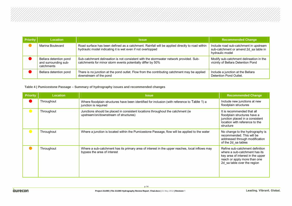
p 14
Project 211090 | File 211090 Hydrography Review Report_Final.docx | 31 May 2012 | Revision 1
Priority Location Issue Recommended Change
Marina Boulevard Road surface has been defined as a catchment. Rainfall will be applied directly to road within hydraulic model indicating it is wet even if not overtopped
Include road sub-catchment in upstream sub-catchment or amend 2d_sa table in hydraulic model
Bellara detention pond and surrounding sub-catchments
Sub-catchment delineation is not consistent with the stormwater network provided. Sub-catchments for minor storm events potentially differ by 50%
Modify sub-catchment delineation in the vicinity of Bellara Detention Pond
Bellara detention pond There is no junction at the pond outlet. Flow from the contributing catchment may be applied downstream of the pond
Include a junction at the Bellara Detention Pond Outlet.
Table 4 | Pumicestone Passage – Summary of hydrography issues and recommended changes
Priority Location Issue Recommended Change
Throughout Where floodplain structures have been identified for inclusion (with reference to Table 1) a junction is required
Include new junctions at new floodplain structures
Throughout Junctions should be placed in consistent locations throughout the catchment (ie upstream/on/downstream of structures)
It is recommended that all floodplain structures have a junction placed in a consistent location with reference to the structure
Throughout Where a junction is located within the Pumicestone Passage, flow will be applied to the water No change to the hydrography is recommended. This will be addressed through modification of the 2d_sa tables
Throughout Where a sub-catchment has its primary area of interest in the upper reaches, local inflows may bypass the area of interest
Refine sub-catchment definition where a sub-catchment has its key area of interest in the upper reach or apply more than one 2d_sa table over the region
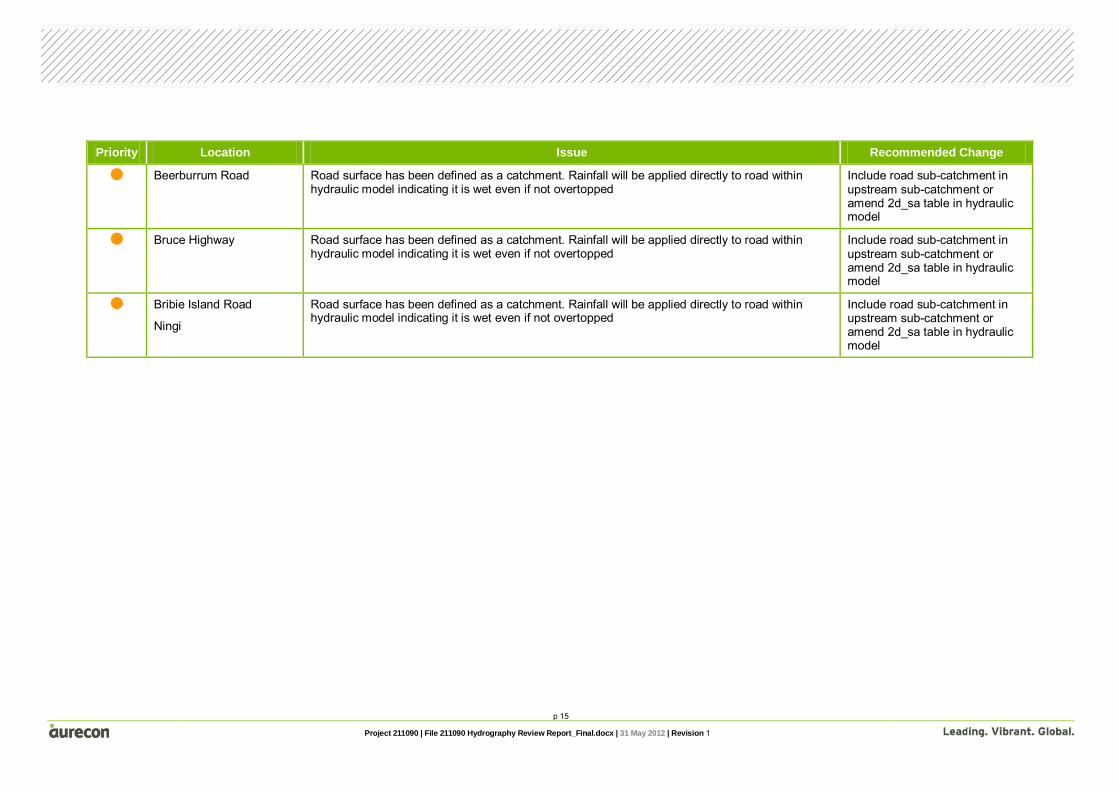
p 15
Project 211090 | File 211090 Hydrography Review Report_Final.docx | 31 May 2012 | Revision 1
Priority Location Issue Recommended Change
Beerburrum Road Road surface has been defined as a catchment. Rainfall will be applied directly to road within hydraulic model indicating it is wet even if not overtopped
Include road sub-catchment in upstream sub-catchment or amend 2d_sa table in hydraulic model
Bruce Highway Road surface has been defined as a catchment. Rainfall will be applied directly to road within hydraulic model indicating it is wet even if not overtopped
Include road sub-catchment in upstream sub-catchment or amend 2d_sa table in hydraulic model
Bribie Island Road
Ningi
Road surface has been defined as a catchment. Rainfall will be applied directly to road within hydraulic model indicating it is wet even if not overtopped
Include road sub-catchment in upstream sub-catchment or amend 2d_sa table in hydraulic model

p 16
Project 211090 | File 211090 Hydrography Review Report_Final.docx | 31 May 2012 | Revision 1
Generally, the defined hydrography is considered to be appropriate for the project objectives. Table 2 and Table 3 present recommended changes to the hydrography for the Bribie Island and Pumicestone Passage minor basins. The changes have been presented with a suggested order of priority. It is advised that Council modify the sub-catchments in line with the high priority recommendations (red). The medium (orange) recommendations should also be modified if resources and budget allow it. The low priority recommendations have been included for reference but are unlikely to impact the objectives of the study.
In a number of instances, the application of the flow within the hydraulic model may be modified instead of the hydrography. This has been noted in the summary tables and associated discussion.
It is also recommended that Council reference the latest available Local Plans for the region and consider if further sub-catchment delineation is required to support the “future development” scenarios. Based on the information available for this report, there are no areas of significant development within the Package 3 basins.
4 Recommendations

p 17
Project 211090 | File 211090 Hydrography Review Report_Final.docx | 31 May 2012 | Revision 1
5.1 Documents Cardno (2009), Bellara Drainage Investigation - Relief Drainage Options, 23 January 2009
Cardno (2008), Bellara Drainage Investigation - Park Lines Relief Drainage Options, 23 December 2008
BMT WBM (2010) Hydraulic Modelling (Broadscale) Regional Floodplain Database - Stage 1 Sub-Project 1D, July 2010
Caboolture Shire Council (2005) Caboolture Shire Plan, December 2005
5.2 Other data Bribie Island stormwater trunk drainage network, as provided by Council September 2010
5 References


Aurecon Australia Pty Ltd ABN 54 005 139 873 Level 14, 32 Turbot Street Brisbane QLD 4000 Locked Bag 331 Brisbane QLD 4001 Australia T +61 7 3173 8000 F +61 7 3173 8001 E [email protected] W aurecongroup.com Aurecon offices are located in: Angola, Australia, Botswana, China, Ethiopia, Hong Kong, Indonesia, Lesotho, Libya, Malawi, Mozambique, Namibia, New Zealand, Nigeria, Philippines, Singapore, South Africa, Swaziland, Tanzania, Thailand, Uganda, United Arab Emirates, Vietnam.

Appendix C Calibration and Validation
Report(s)

Appendix C Calibration and Validation Report(s)

Project: Regional Floodplain Database Stage 2 Detailed Modelling – Package 3: Pumicestone Passage and Bribie Island Calibration and Validation Feasibility Report
Reference: 211090
Prepared for: Moreton Bay Regional Council
Revision: 1
31 May 2012


Project 211090 | File 211090 Calibration and Validation Feasibility Report_Final.docx | 31 May 2012 | Revision 1
Regional Floodplain Database Stage 2 Detailed Modelling – Package 3: Pumicestone Passage and Bribie Island
Date | 31 May 2012 Reference | 211090 Revision | 1
Aurecon Australia Pty Ltd ABN 54 005 139 873 Level 14, 32 Turbot Street Brisbane QLD 4000 Locked Bag 331 Brisbane QLD 4001 Australia T F E W
+61 7 3173 8000 +61 7 3173 8001 [email protected] aurecongroup.com

p 1
Project 211090 | File 211090 Calibration and Validation Feasibility Report_Final.docx | 31 May 2012 | Revision 1
Contents 1 Introduction 2
1.1 Study objective 2 1.2 Objective of calibration and validation feasibility report 2
2 Available data 4
2.1 Stream gauge data 4 2.2 Rainfall data 4 2.3 Historic flood marks 5
3 Flood events 6
3.1 Possible events for calibration/validation 6 3.2 Feasibility of calibration/validation 6
4 Recommendations 7 5 References 8
Appendices Appendix A
Figures
Index of Figures Figure 1 | MBRC Gauge Data Locations Figure 2 | WRSC Gauge Data Locations
Index of Tables Table 1 | Alert/Pluviograph Stations .....................................................................................................4 Table 2 | Daily rainfall stations .............................................................................................................5

p 2
Project 211090 | File 211090 Calibration and Validation Feasibility Report_Final.docx | 31 May 2012 | Revision 1
1.1 Study objective Moreton Bay Regional Council (MBRC) is delivering a Regional Floodplain Database (RFD) in support of their flood risk management, considering emergency response, development control, strategic landuse and infrastructure planning. The MBRC was recently formed under local government amalgamations and is responsible for Caboolture, Pine Rivers, Redcliffe and Bribie Island. The RFD project is focusing on the northern sector as a key growth area for south east Queensland.
The project is being funded by MBRC, Emergency Management Queensland (EMQ) and Emergency Management Australia (EMA) as part of the Disaster Resilience Program and will provide:
• A comprehensive and consistent description of flood behaviour across the region • Strategies for management of any flooding problems identified • A system/process to store and manage this information and keep it up-to-date Stage 1 of the project was completed in July 2010 and involved a number of sub-projects. These projects delivered consistent processes and protocols for the detailed hydrologic and hydraulic model development. A key sub-project involved the development of broadscale hydrodynamic models for each minor basin to provide general understanding of flooding mechanisms and allow prioritisation of data capture.
Stage 2 (current stage) of the project involves the development of detailed hydrologic and hydraulic models for each minor basin.
Stage 3 will build on the detailed models and “add value” through assessment of flood damages and community resilience measures.
1.2 Objective of calibration and validation feasibility report This report pertains to the calibration and validation analysis for Package 3, including:
• Bribie Island • Pumicestone Passage (including Six Mile, Beerburrum, Elimbah, Ningi and Glass Mountain
Creeks) The Pumicestone Passage basin is mostly rural, with flood-prone lower reaches. There are a large number of structures in this basin, with the potential to impact upon flooding of urban areas. Additionally, accurate modelling of breakout flows travelling between the lower reaches of Ningi and Elimbah Creeks will be important.
1 Introduction

p 3
Project 211090 | File 211090 Calibration and Validation Feasibility Report_Final.docx | 31 May 2012 | Revision 1
The Bribie Island catchment has significant flooding through some urban areas and canal estates. Representation of urban flowpaths and structures will be important to the accurate modelling of this catchment.
This report assesses the feasibility of carrying out calibration and validation for the hydrological and hydraulic modelling of the Pumicestone Passage and Bribie Island basins based on the current and prospective availability of data.

p 4
Project 211090 | File 211090 Calibration and Validation Feasibility Report_Final.docx | 31 May 2012 | Revision 1
2.1 Stream gauge data Stream gauge data (recorded water level with respect to time) is essential to calibrating a hydrologic model. Recorded water levels are converted to discharges and compared with hydrologic model predictions. Stream gauge data is also useful in calibrating a hydraulic model through comparisons of recorded and predicted water levels with time at the gauge location. Unfortunately, there are no stream gauges within either the Pumicestone Passage or Bribie Island basins.
2.2 Rainfall data Rainfall data is used to provide input to a hydrologic model regarding the amount, location and timing of rainfall during a storm event.
Rainfall station locations have been sourced from Moreton Bay Regional Council (MBRC) and the Bureau of Meteorology’s (BoM) Water Resources Station Catalogue (WRSC). The gauge locations obtained from these sources are shown in Figure 1 and Figure 2 respectively. There are two types of rainfall stations:
• Alert station (or pluviometer) – rainfall is recorded in short duration intervals (as short as 6 minutes) providing rainfall patterns through the course of a rainfall event
• Daily station – total rainfall during the course of a day is recorded The alert stations and daily stations within the zone of influence to the Pumicestone Passage and Bribie Island Basins have been provided in Table 1 and Table 2 respectively. The rainfall data has not yet been sourced for these stations. In a number of locations the data sets have conflicting information in regards to gauge ownership, therefore the information from both sources has been provided in the tables below.
Table 1 | Alert/Pluviograph Stations
Gauge Name Gauge Owner/Data Source
Operational Start Date Operational Finish Date
Old Gympie Road SCRC/BoM 7/5/2004 Still operational
Beerwah SCRC/BoM 7/5/2004 Still operational
Woodford SEQWC/BoM 15/5/2002 Still operational
Wamuran MBRC/BoM 30/9/1998 Still operational
Round Mtn Reservoir MBRC/BoM 7/1/1998 Still operational
Caboolture WTP MBRC/BoM 7/1/1998 Still operational
2 Available data
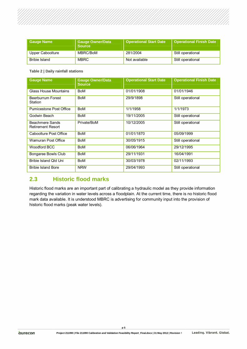
p 5
Project 211090 | File 211090 Calibration and Validation Feasibility Report_Final.docx | 31 May 2012 | Revision 1
Gauge Name Gauge Owner/Data Source
Operational Start Date Operational Finish Date
Upper Caboolture MBRC/BoM 281/2004 Still operational
Bribie Island MBRC Not available Still operational
Table 2 | Daily rainfall stations
Gauge Name Gauge Owner/Data Source
Operational Start Date Operational Finish Date
Glass House Mountains BoM 01/01/1908 01/01/1946
Beerburrum Forest Station
BoM 29/9/1898 Still operational
Pumicestone Post Office BoM 1/1/1958 1/1/1973
Godwin Beach BoM 19/11/2005 Still operational
Beachmere Sands Retirement Resort
Private/BoM 10/12/2005 Still operational
Caboolture Post Office BoM 01/01/1870 05/09/1999
Wamuran Post Office BoM 30/05/1915 Still operational
Woodford BCC BoM 06/06/1964 29/12/1995
Bongaree Bowls Club BoM 29/11/1931 16/04/1991
Bribie Island Qld Uni BoM 30/03/1978 02/11/1993
Bribie Island Bore NRW 29/04/1993 Still operational
2.3 Historic flood marks Historic flood marks are an important part of calibrating a hydraulic model as they provide information regarding the variation in water levels across a floodplain. At the current time, there is no historic flood mark data available. It is understood MBRC is advertising for community input into the provision of historic flood marks (peak water levels).

p 6
Project 211090 | File 211090 Calibration and Validation Feasibility Report_Final.docx | 31 May 2012 | Revision 1
3.1 Possible events for calibration/validation It is possible to undertake an assessment of the available rainfall data to determine when rainfall events occurred. This data could be used to assess which rainfall events were likely to have led to flood events and therefore identify the historic periods in which MBRC should target sourcing of community data. We will undertake this rainfall assessment if MBRC feels it is required.
3.2 Feasibility of calibration/validation Given the lack of recorded stream gauge data within either the Pumicestone Passage or Bribie Island basins, it will not be possible to calibrate the WBNM models. If a number of reliable historic flood marks are sourced from the community it may be possible to undertake a joint calibration process in which both hydrologic and hydraulic parameters are modified until calibration of the hydraulic model is achieved.
Historic flood mark data sourced from the community is less reliable than surveyed flood data as it relies on community recollection of peak water levels or remaining debris following a flood event. As a result, calibration would be limited in accuracy if this was the only source of historic data.
We recommend that the calibration and validation feasibility for Pumicestone Passage and Bribie Island be reviewed once flood mark data is obtained and the quality of the data is assessed.
3 Flood events

p 7
Project 211090 | File 211090 Calibration and Validation Feasibility Report_Final.docx | 31 May 2012 | Revision 1
In order to carry out calibration/validation of a hydrologic model, rainfall and stream gauge data needs to be available. No stream gauge data is available within the Pumicestone Passage or Bribie Island basins.
To calibrate/validate a hydraulic model, both rainfall and water level data needs to be available. At present only rainfall data is available within the Pumicestone Passage and Bribie Island catchments. No stream gauge or historic flood mark records exist within these basins which would provide water level data. The feasibility of model calibration and validation will therefore be dependant on the amount and quality of information obtained from the community in regards to historic flood water levels.
4 Recommendations

p 8
Project 211090 | File 211090 Calibration and Validation Feasibility Report_Final.docx | 31 May 2012 | Revision 1
Bureau of Meteorology, Water Resources Station Catalogue [Online] Available: http://www.bom.gov.au/hydro/wrsc Accessed October 2010
Gauges GIS data, as provided by Council, September 2010
5 References


Appendices


Appendix A Figures


Woodford BccWoodford BccWoodford BccWoodford BccWoodford BccWoodford BccWoodford BccWoodford BccWoodford BccWoodford BccWoodford BccWoodford BccWoodford BccWoodford BccWoodford BccWoodford BccWoodford BccWoodford BccWoodford BccWoodford BccWoodford BccWoodford BccWoodford BccWoodford BccWoodford BccWoodford BccWoodford BccWoodford BccWoodford BccWoodford BccWoodford BccWoodford BccWoodford BccWoodford BccWoodford BccWoodford BccWoodford BccWoodford BccWoodford BccWoodford BccWoodford BccWoodford BccWoodford BccWoodford BccWoodford BccWoodford BccWoodford BccWoodford BccWoodford Bcc
Stanley River at WoodfordStanley River at WoodfordStanley River at WoodfordStanley River at WoodfordStanley River at WoodfordStanley River at WoodfordStanley River at WoodfordStanley River at WoodfordStanley River at WoodfordStanley River at WoodfordStanley River at WoodfordStanley River at WoodfordStanley River at WoodfordStanley River at WoodfordStanley River at WoodfordStanley River at WoodfordStanley River at WoodfordStanley River at WoodfordStanley River at WoodfordStanley River at WoodfordStanley River at WoodfordStanley River at WoodfordStanley River at WoodfordStanley River at WoodfordStanley River at WoodfordStanley River at WoodfordStanley River at WoodfordStanley River at WoodfordStanley River at WoodfordStanley River at WoodfordStanley River at WoodfordStanley River at WoodfordStanley River at WoodfordStanley River at WoodfordStanley River at WoodfordStanley River at WoodfordStanley River at WoodfordStanley River at WoodfordStanley River at WoodfordStanley River at WoodfordStanley River at WoodfordStanley River at WoodfordStanley River at WoodfordStanley River at WoodfordStanley River at WoodfordStanley River at WoodfordStanley River at WoodfordStanley River at WoodfordStanley River at Woodford
Mt MeeMt MeeMt MeeMt MeeMt MeeMt MeeMt MeeMt MeeMt MeeMt MeeMt MeeMt MeeMt MeeMt MeeMt MeeMt MeeMt MeeMt MeeMt MeeMt MeeMt MeeMt MeeMt MeeMt MeeMt MeeMt MeeMt MeeMt MeeMt MeeMt MeeMt MeeMt MeeMt MeeMt MeeMt MeeMt MeeMt MeeMt MeeMt MeeMt MeeMt MeeMt MeeMt MeeMt MeeMt MeeMt MeeMt MeeMt MeeMt Mee
Caboolture WTP ALCaboolture WTP ALCaboolture WTP ALCaboolture WTP ALCaboolture WTP ALCaboolture WTP ALCaboolture WTP ALCaboolture WTP ALCaboolture WTP ALCaboolture WTP ALCaboolture WTP ALCaboolture WTP ALCaboolture WTP ALCaboolture WTP ALCaboolture WTP ALCaboolture WTP ALCaboolture WTP ALCaboolture WTP ALCaboolture WTP ALCaboolture WTP ALCaboolture WTP ALCaboolture WTP ALCaboolture WTP ALCaboolture WTP ALCaboolture WTP ALCaboolture WTP ALCaboolture WTP ALCaboolture WTP ALCaboolture WTP ALCaboolture WTP ALCaboolture WTP ALCaboolture WTP ALCaboolture WTP ALCaboolture WTP ALCaboolture WTP ALCaboolture WTP ALCaboolture WTP ALCaboolture WTP ALCaboolture WTP ALCaboolture WTP ALCaboolture WTP ALCaboolture WTP ALCaboolture WTP ALCaboolture WTP ALCaboolture WTP ALCaboolture WTP ALCaboolture WTP ALCaboolture WTP ALCaboolture WTP AL
Old Gympie Road ALOld Gympie Road ALOld Gympie Road ALOld Gympie Road ALOld Gympie Road ALOld Gympie Road ALOld Gympie Road ALOld Gympie Road ALOld Gympie Road ALOld Gympie Road ALOld Gympie Road ALOld Gympie Road ALOld Gympie Road ALOld Gympie Road ALOld Gympie Road ALOld Gympie Road ALOld Gympie Road ALOld Gympie Road ALOld Gympie Road ALOld Gympie Road ALOld Gympie Road ALOld Gympie Road ALOld Gympie Road ALOld Gympie Road ALOld Gympie Road ALOld Gympie Road ALOld Gympie Road ALOld Gympie Road ALOld Gympie Road ALOld Gympie Road ALOld Gympie Road ALOld Gympie Road ALOld Gympie Road ALOld Gympie Road ALOld Gympie Road ALOld Gympie Road ALOld Gympie Road ALOld Gympie Road ALOld Gympie Road ALOld Gympie Road ALOld Gympie Road ALOld Gympie Road ALOld Gympie Road ALOld Gympie Road ALOld Gympie Road ALOld Gympie Road ALOld Gympie Road ALOld Gympie Road ALOld Gympie Road AL
Beachmere ALBeachmere ALBeachmere ALBeachmere ALBeachmere ALBeachmere ALBeachmere ALBeachmere ALBeachmere ALBeachmere ALBeachmere ALBeachmere ALBeachmere ALBeachmere ALBeachmere ALBeachmere ALBeachmere ALBeachmere ALBeachmere ALBeachmere ALBeachmere ALBeachmere ALBeachmere ALBeachmere ALBeachmere ALBeachmere ALBeachmere ALBeachmere ALBeachmere ALBeachmere ALBeachmere ALBeachmere ALBeachmere ALBeachmere ALBeachmere ALBeachmere ALBeachmere ALBeachmere ALBeachmere ALBeachmere ALBeachmere ALBeachmere ALBeachmere ALBeachmere ALBeachmere ALBeachmere ALBeachmere ALBeachmere ALBeachmere AL
Beachmere Sands Retirement ResortBeachmere Sands Retirement ResortBeachmere Sands Retirement ResortBeachmere Sands Retirement ResortBeachmere Sands Retirement ResortBeachmere Sands Retirement ResortBeachmere Sands Retirement ResortBeachmere Sands Retirement ResortBeachmere Sands Retirement ResortBeachmere Sands Retirement ResortBeachmere Sands Retirement ResortBeachmere Sands Retirement ResortBeachmere Sands Retirement ResortBeachmere Sands Retirement ResortBeachmere Sands Retirement ResortBeachmere Sands Retirement ResortBeachmere Sands Retirement ResortBeachmere Sands Retirement ResortBeachmere Sands Retirement ResortBeachmere Sands Retirement ResortBeachmere Sands Retirement ResortBeachmere Sands Retirement ResortBeachmere Sands Retirement ResortBeachmere Sands Retirement ResortBeachmere Sands Retirement ResortBeachmere Sands Retirement ResortBeachmere Sands Retirement ResortBeachmere Sands Retirement ResortBeachmere Sands Retirement ResortBeachmere Sands Retirement ResortBeachmere Sands Retirement ResortBeachmere Sands Retirement ResortBeachmere Sands Retirement ResortBeachmere Sands Retirement ResortBeachmere Sands Retirement ResortBeachmere Sands Retirement ResortBeachmere Sands Retirement ResortBeachmere Sands Retirement ResortBeachmere Sands Retirement ResortBeachmere Sands Retirement ResortBeachmere Sands Retirement ResortBeachmere Sands Retirement ResortBeachmere Sands Retirement ResortBeachmere Sands Retirement ResortBeachmere Sands Retirement ResortBeachmere Sands Retirement ResortBeachmere Sands Retirement ResortBeachmere Sands Retirement ResortBeachmere Sands Retirement Resort
Beerburrum Forest StationBeerburrum Forest StationBeerburrum Forest StationBeerburrum Forest StationBeerburrum Forest StationBeerburrum Forest StationBeerburrum Forest StationBeerburrum Forest StationBeerburrum Forest StationBeerburrum Forest StationBeerburrum Forest StationBeerburrum Forest StationBeerburrum Forest StationBeerburrum Forest StationBeerburrum Forest StationBeerburrum Forest StationBeerburrum Forest StationBeerburrum Forest StationBeerburrum Forest StationBeerburrum Forest StationBeerburrum Forest StationBeerburrum Forest StationBeerburrum Forest StationBeerburrum Forest StationBeerburrum Forest StationBeerburrum Forest StationBeerburrum Forest StationBeerburrum Forest StationBeerburrum Forest StationBeerburrum Forest StationBeerburrum Forest StationBeerburrum Forest StationBeerburrum Forest StationBeerburrum Forest StationBeerburrum Forest StationBeerburrum Forest StationBeerburrum Forest StationBeerburrum Forest StationBeerburrum Forest StationBeerburrum Forest StationBeerburrum Forest StationBeerburrum Forest StationBeerburrum Forest StationBeerburrum Forest StationBeerburrum Forest StationBeerburrum Forest StationBeerburrum Forest StationBeerburrum Forest StationBeerburrum Forest Station
Beerwah ALBeerwah ALBeerwah ALBeerwah ALBeerwah ALBeerwah ALBeerwah ALBeerwah ALBeerwah ALBeerwah ALBeerwah ALBeerwah ALBeerwah ALBeerwah ALBeerwah ALBeerwah ALBeerwah ALBeerwah ALBeerwah ALBeerwah ALBeerwah ALBeerwah ALBeerwah ALBeerwah ALBeerwah ALBeerwah ALBeerwah ALBeerwah ALBeerwah ALBeerwah ALBeerwah ALBeerwah ALBeerwah ALBeerwah ALBeerwah ALBeerwah ALBeerwah ALBeerwah ALBeerwah ALBeerwah ALBeerwah ALBeerwah ALBeerwah ALBeerwah ALBeerwah ALBeerwah ALBeerwah ALBeerwah ALBeerwah AL
Beerwah Csiro Res StnBeerwah Csiro Res StnBeerwah Csiro Res StnBeerwah Csiro Res StnBeerwah Csiro Res StnBeerwah Csiro Res StnBeerwah Csiro Res StnBeerwah Csiro Res StnBeerwah Csiro Res StnBeerwah Csiro Res StnBeerwah Csiro Res StnBeerwah Csiro Res StnBeerwah Csiro Res StnBeerwah Csiro Res StnBeerwah Csiro Res StnBeerwah Csiro Res StnBeerwah Csiro Res StnBeerwah Csiro Res StnBeerwah Csiro Res StnBeerwah Csiro Res StnBeerwah Csiro Res StnBeerwah Csiro Res StnBeerwah Csiro Res StnBeerwah Csiro Res StnBeerwah Csiro Res StnBeerwah Csiro Res StnBeerwah Csiro Res StnBeerwah Csiro Res StnBeerwah Csiro Res StnBeerwah Csiro Res StnBeerwah Csiro Res StnBeerwah Csiro Res StnBeerwah Csiro Res StnBeerwah Csiro Res StnBeerwah Csiro Res StnBeerwah Csiro Res StnBeerwah Csiro Res StnBeerwah Csiro Res StnBeerwah Csiro Res StnBeerwah Csiro Res StnBeerwah Csiro Res StnBeerwah Csiro Res StnBeerwah Csiro Res StnBeerwah Csiro Res StnBeerwah Csiro Res StnBeerwah Csiro Res StnBeerwah Csiro Res StnBeerwah Csiro Res StnBeerwah Csiro Res Stn
Beerwah ForestBeerwah ForestBeerwah ForestBeerwah ForestBeerwah ForestBeerwah ForestBeerwah ForestBeerwah ForestBeerwah ForestBeerwah ForestBeerwah ForestBeerwah ForestBeerwah ForestBeerwah ForestBeerwah ForestBeerwah ForestBeerwah ForestBeerwah ForestBeerwah ForestBeerwah ForestBeerwah ForestBeerwah ForestBeerwah ForestBeerwah ForestBeerwah ForestBeerwah ForestBeerwah ForestBeerwah ForestBeerwah ForestBeerwah ForestBeerwah ForestBeerwah ForestBeerwah ForestBeerwah ForestBeerwah ForestBeerwah ForestBeerwah ForestBeerwah ForestBeerwah ForestBeerwah ForestBeerwah ForestBeerwah ForestBeerwah ForestBeerwah ForestBeerwah ForestBeerwah ForestBeerwah ForestBeerwah ForestBeerwah Forest
Bribie Island ALBribie Island ALBribie Island ALBribie Island ALBribie Island ALBribie Island ALBribie Island ALBribie Island ALBribie Island ALBribie Island ALBribie Island ALBribie Island ALBribie Island ALBribie Island ALBribie Island ALBribie Island ALBribie Island ALBribie Island ALBribie Island ALBribie Island ALBribie Island ALBribie Island ALBribie Island ALBribie Island ALBribie Island ALBribie Island ALBribie Island ALBribie Island ALBribie Island ALBribie Island ALBribie Island ALBribie Island ALBribie Island ALBribie Island ALBribie Island ALBribie Island ALBribie Island ALBribie Island ALBribie Island ALBribie Island ALBribie Island ALBribie Island ALBribie Island ALBribie Island ALBribie Island ALBribie Island ALBribie Island ALBribie Island ALBribie Island AL
Burpengary (Dale St) AlBurpengary (Dale St) AlBurpengary (Dale St) AlBurpengary (Dale St) AlBurpengary (Dale St) AlBurpengary (Dale St) AlBurpengary (Dale St) AlBurpengary (Dale St) AlBurpengary (Dale St) AlBurpengary (Dale St) AlBurpengary (Dale St) AlBurpengary (Dale St) AlBurpengary (Dale St) AlBurpengary (Dale St) AlBurpengary (Dale St) AlBurpengary (Dale St) AlBurpengary (Dale St) AlBurpengary (Dale St) AlBurpengary (Dale St) AlBurpengary (Dale St) AlBurpengary (Dale St) AlBurpengary (Dale St) AlBurpengary (Dale St) AlBurpengary (Dale St) AlBurpengary (Dale St) AlBurpengary (Dale St) AlBurpengary (Dale St) AlBurpengary (Dale St) AlBurpengary (Dale St) AlBurpengary (Dale St) AlBurpengary (Dale St) AlBurpengary (Dale St) AlBurpengary (Dale St) AlBurpengary (Dale St) AlBurpengary (Dale St) AlBurpengary (Dale St) AlBurpengary (Dale St) AlBurpengary (Dale St) AlBurpengary (Dale St) AlBurpengary (Dale St) AlBurpengary (Dale St) AlBurpengary (Dale St) AlBurpengary (Dale St) AlBurpengary (Dale St) AlBurpengary (Dale St) AlBurpengary (Dale St) AlBurpengary (Dale St) AlBurpengary (Dale St) AlBurpengary (Dale St) Al
Burpengary(Rowley Rd) ALBurpengary(Rowley Rd) ALBurpengary(Rowley Rd) ALBurpengary(Rowley Rd) ALBurpengary(Rowley Rd) ALBurpengary(Rowley Rd) ALBurpengary(Rowley Rd) ALBurpengary(Rowley Rd) ALBurpengary(Rowley Rd) ALBurpengary(Rowley Rd) ALBurpengary(Rowley Rd) ALBurpengary(Rowley Rd) ALBurpengary(Rowley Rd) ALBurpengary(Rowley Rd) ALBurpengary(Rowley Rd) ALBurpengary(Rowley Rd) ALBurpengary(Rowley Rd) ALBurpengary(Rowley Rd) ALBurpengary(Rowley Rd) ALBurpengary(Rowley Rd) ALBurpengary(Rowley Rd) ALBurpengary(Rowley Rd) ALBurpengary(Rowley Rd) ALBurpengary(Rowley Rd) ALBurpengary(Rowley Rd) ALBurpengary(Rowley Rd) ALBurpengary(Rowley Rd) ALBurpengary(Rowley Rd) ALBurpengary(Rowley Rd) ALBurpengary(Rowley Rd) ALBurpengary(Rowley Rd) ALBurpengary(Rowley Rd) ALBurpengary(Rowley Rd) ALBurpengary(Rowley Rd) ALBurpengary(Rowley Rd) ALBurpengary(Rowley Rd) ALBurpengary(Rowley Rd) ALBurpengary(Rowley Rd) ALBurpengary(Rowley Rd) ALBurpengary(Rowley Rd) ALBurpengary(Rowley Rd) ALBurpengary(Rowley Rd) ALBurpengary(Rowley Rd) ALBurpengary(Rowley Rd) ALBurpengary(Rowley Rd) ALBurpengary(Rowley Rd) ALBurpengary(Rowley Rd) ALBurpengary(Rowley Rd) ALBurpengary(Rowley Rd) AL
Caboolture Post OfficeCaboolture Post OfficeCaboolture Post OfficeCaboolture Post OfficeCaboolture Post OfficeCaboolture Post OfficeCaboolture Post OfficeCaboolture Post OfficeCaboolture Post OfficeCaboolture Post OfficeCaboolture Post OfficeCaboolture Post OfficeCaboolture Post OfficeCaboolture Post OfficeCaboolture Post OfficeCaboolture Post OfficeCaboolture Post OfficeCaboolture Post OfficeCaboolture Post OfficeCaboolture Post OfficeCaboolture Post OfficeCaboolture Post OfficeCaboolture Post OfficeCaboolture Post OfficeCaboolture Post OfficeCaboolture Post OfficeCaboolture Post OfficeCaboolture Post OfficeCaboolture Post OfficeCaboolture Post OfficeCaboolture Post OfficeCaboolture Post OfficeCaboolture Post OfficeCaboolture Post OfficeCaboolture Post OfficeCaboolture Post OfficeCaboolture Post OfficeCaboolture Post OfficeCaboolture Post OfficeCaboolture Post OfficeCaboolture Post OfficeCaboolture Post OfficeCaboolture Post OfficeCaboolture Post OfficeCaboolture Post OfficeCaboolture Post OfficeCaboolture Post OfficeCaboolture Post OfficeCaboolture Post Office
Deception Bay ALDeception Bay ALDeception Bay ALDeception Bay ALDeception Bay ALDeception Bay ALDeception Bay ALDeception Bay ALDeception Bay ALDeception Bay ALDeception Bay ALDeception Bay ALDeception Bay ALDeception Bay ALDeception Bay ALDeception Bay ALDeception Bay ALDeception Bay ALDeception Bay ALDeception Bay ALDeception Bay ALDeception Bay ALDeception Bay ALDeception Bay ALDeception Bay ALDeception Bay ALDeception Bay ALDeception Bay AL
Ferris KnobFerris KnobFerris KnobFerris KnobFerris KnobFerris KnobFerris KnobFerris KnobFerris KnobFerris KnobFerris KnobFerris KnobFerris KnobFerris KnobFerris KnobFerris KnobFerris KnobFerris KnobFerris KnobFerris KnobFerris KnobFerris KnobFerris KnobFerris KnobFerris KnobFerris KnobFerris KnobFerris KnobFerris KnobFerris KnobFerris KnobFerris KnobFerris KnobFerris KnobFerris KnobFerris KnobFerris KnobFerris KnobFerris KnobFerris KnobFerris KnobFerris KnobFerris KnobFerris KnobFerris KnobFerris KnobFerris KnobFerris KnobFerris Knob
Godwin BeachGodwin BeachGodwin BeachGodwin BeachGodwin BeachGodwin BeachGodwin BeachGodwin BeachGodwin BeachGodwin BeachGodwin BeachGodwin BeachGodwin BeachGodwin BeachGodwin BeachGodwin BeachGodwin BeachGodwin BeachGodwin BeachGodwin BeachGodwin BeachGodwin BeachGodwin BeachGodwin BeachGodwin BeachGodwin BeachGodwin BeachGodwin BeachGodwin BeachGodwin BeachGodwin BeachGodwin BeachGodwin BeachGodwin BeachGodwin BeachGodwin BeachGodwin BeachGodwin BeachGodwin BeachGodwin BeachGodwin BeachGodwin BeachGodwin BeachGodwin BeachGodwin BeachGodwin BeachGodwin BeachGodwin BeachGodwin Beach
Hume Lane ALHume Lane ALHume Lane ALHume Lane ALHume Lane ALHume Lane ALHume Lane ALHume Lane ALHume Lane ALHume Lane ALHume Lane ALHume Lane ALHume Lane ALHume Lane ALHume Lane ALHume Lane ALHume Lane ALHume Lane ALHume Lane ALHume Lane ALHume Lane ALHume Lane ALHume Lane ALHume Lane ALHume Lane ALHume Lane ALHume Lane ALHume Lane ALHume Lane ALHume Lane ALHume Lane ALHume Lane ALHume Lane ALHume Lane ALHume Lane ALHume Lane ALHume Lane ALHume Lane ALHume Lane ALHume Lane ALHume Lane ALHume Lane ALHume Lane ALHume Lane ALHume Lane ALHume Lane ALHume Lane ALHume Lane ALHume Lane AL
Mawsons Road TmMawsons Road TmMawsons Road TmMawsons Road TmMawsons Road TmMawsons Road TmMawsons Road TmMawsons Road TmMawsons Road TmMawsons Road TmMawsons Road TmMawsons Road TmMawsons Road TmMawsons Road TmMawsons Road TmMawsons Road TmMawsons Road TmMawsons Road TmMawsons Road TmMawsons Road TmMawsons Road TmMawsons Road TmMawsons Road TmMawsons Road TmMawsons Road TmMawsons Road TmMawsons Road TmMawsons Road TmMawsons Road TmMawsons Road TmMawsons Road TmMawsons Road TmMawsons Road TmMawsons Road TmMawsons Road TmMawsons Road TmMawsons Road TmMawsons Road TmMawsons Road TmMawsons Road TmMawsons Road TmMawsons Road TmMawsons Road TmMawsons Road TmMawsons Road TmMawsons Road TmMawsons Road TmMawsons Road TmMawsons Road Tm
MoorinaMoorinaMoorinaMoorinaMoorinaMoorinaMoorinaMoorinaMoorinaMoorinaMoorinaMoorinaMoorinaMoorinaMoorinaMoorinaMoorinaMoorinaMoorinaMoorinaMoorinaMoorinaMoorinaMoorinaMoorinaMoorinaMoorinaMoorinaMoorinaMoorinaMoorinaMoorinaMoorinaMoorinaMoorinaMoorinaMoorinaMoorinaMoorinaMoorinaMoorinaMoorinaMoorinaMoorinaMoorinaMoorinaMoorinaMoorinaMoorina
Morayfield ALMorayfield ALMorayfield ALMorayfield ALMorayfield ALMorayfield ALMorayfield ALMorayfield ALMorayfield ALMorayfield ALMorayfield ALMorayfield ALMorayfield ALMorayfield ALMorayfield ALMorayfield ALMorayfield ALMorayfield ALMorayfield ALMorayfield ALMorayfield ALMorayfield ALMorayfield ALMorayfield ALMorayfield ALMorayfield ALMorayfield ALMorayfield ALMorayfield ALMorayfield ALMorayfield ALMorayfield ALMorayfield ALMorayfield ALMorayfield ALMorayfield ALMorayfield ALMorayfield ALMorayfield ALMorayfield ALMorayfield ALMorayfield ALMorayfield ALMorayfield ALMorayfield ALMorayfield ALMorayfield ALMorayfield ALMorayfield AL
Morayfield Mark StMorayfield Mark StMorayfield Mark StMorayfield Mark StMorayfield Mark StMorayfield Mark StMorayfield Mark StMorayfield Mark StMorayfield Mark StMorayfield Mark StMorayfield Mark StMorayfield Mark StMorayfield Mark StMorayfield Mark StMorayfield Mark StMorayfield Mark StMorayfield Mark StMorayfield Mark StMorayfield Mark StMorayfield Mark StMorayfield Mark StMorayfield Mark StMorayfield Mark StMorayfield Mark StMorayfield Mark StMorayfield Mark StMorayfield Mark StMorayfield Mark StMorayfield Mark StMorayfield Mark StMorayfield Mark StMorayfield Mark StMorayfield Mark StMorayfield Mark StMorayfield Mark StMorayfield Mark StMorayfield Mark StMorayfield Mark StMorayfield Mark StMorayfield Mark StMorayfield Mark StMorayfield Mark StMorayfield Mark StMorayfield Mark StMorayfield Mark StMorayfield Mark StMorayfield Mark StMorayfield Mark StMorayfield Mark St
Mt Mee AL-BMt Mee AL-BMt Mee AL-BMt Mee AL-BMt Mee AL-BMt Mee AL-BMt Mee AL-BMt Mee AL-BMt Mee AL-BMt Mee AL-BMt Mee AL-BMt Mee AL-BMt Mee AL-BMt Mee AL-BMt Mee AL-BMt Mee AL-BMt Mee AL-BMt Mee AL-BMt Mee AL-BMt Mee AL-BMt Mee AL-BMt Mee AL-BMt Mee AL-BMt Mee AL-BMt Mee AL-BMt Mee AL-BMt Mee AL-BMt Mee AL-BMt Mee AL-BMt Mee AL-BMt Mee AL-BMt Mee AL-BMt Mee AL-BMt Mee AL-BMt Mee AL-BMt Mee AL-BMt Mee AL-BMt Mee AL-BMt Mee AL-BMt Mee AL-BMt Mee AL-BMt Mee AL-BMt Mee AL-BMt Mee AL-BMt Mee AL-BMt Mee AL-BMt Mee AL-BMt Mee AL-BMt Mee AL-B
Ocean ViewOcean ViewOcean ViewOcean ViewOcean ViewOcean ViewOcean ViewOcean ViewOcean ViewOcean ViewOcean ViewOcean ViewOcean ViewOcean ViewOcean ViewOcean ViewOcean ViewOcean ViewOcean ViewOcean ViewOcean ViewOcean ViewOcean ViewOcean ViewOcean ViewOcean ViewOcean ViewOcean ViewOcean ViewOcean ViewOcean ViewOcean ViewOcean ViewOcean ViewOcean ViewOcean ViewOcean ViewOcean ViewOcean ViewOcean ViewOcean ViewOcean ViewOcean ViewOcean ViewOcean ViewOcean ViewOcean ViewOcean ViewOcean View
Peachester ALPeachester ALPeachester ALPeachester ALPeachester ALPeachester ALPeachester ALPeachester ALPeachester ALPeachester ALPeachester ALPeachester ALPeachester ALPeachester ALPeachester ALPeachester ALPeachester ALPeachester ALPeachester ALPeachester ALPeachester ALPeachester ALPeachester ALPeachester ALPeachester ALPeachester ALPeachester ALPeachester ALPeachester ALPeachester ALPeachester ALPeachester ALPeachester ALPeachester ALPeachester ALPeachester ALPeachester ALPeachester ALPeachester ALPeachester ALPeachester ALPeachester ALPeachester ALPeachester ALPeachester ALPeachester ALPeachester ALPeachester ALPeachester AL
Pumicestone Post OfficePumicestone Post OfficePumicestone Post OfficePumicestone Post OfficePumicestone Post OfficePumicestone Post OfficePumicestone Post OfficePumicestone Post OfficePumicestone Post OfficePumicestone Post OfficePumicestone Post OfficePumicestone Post OfficePumicestone Post OfficePumicestone Post OfficePumicestone Post OfficePumicestone Post OfficePumicestone Post OfficePumicestone Post OfficePumicestone Post OfficePumicestone Post OfficePumicestone Post OfficePumicestone Post OfficePumicestone Post OfficePumicestone Post OfficePumicestone Post OfficePumicestone Post OfficePumicestone Post OfficePumicestone Post OfficePumicestone Post OfficePumicestone Post OfficePumicestone Post OfficePumicestone Post OfficePumicestone Post OfficePumicestone Post OfficePumicestone Post OfficePumicestone Post OfficePumicestone Post OfficePumicestone Post OfficePumicestone Post OfficePumicestone Post OfficePumicestone Post OfficePumicestone Post OfficePumicestone Post OfficePumicestone Post OfficePumicestone Post OfficePumicestone Post OfficePumicestone Post OfficePumicestone Post OfficePumicestone Post Office
Round Mt ReservoirRound Mt ReservoirRound Mt ReservoirRound Mt ReservoirRound Mt ReservoirRound Mt ReservoirRound Mt ReservoirRound Mt ReservoirRound Mt ReservoirRound Mt ReservoirRound Mt ReservoirRound Mt ReservoirRound Mt ReservoirRound Mt ReservoirRound Mt ReservoirRound Mt ReservoirRound Mt ReservoirRound Mt ReservoirRound Mt ReservoirRound Mt ReservoirRound Mt ReservoirRound Mt ReservoirRound Mt ReservoirRound Mt ReservoirRound Mt ReservoirRound Mt ReservoirRound Mt ReservoirRound Mt ReservoirRound Mt ReservoirRound Mt ReservoirRound Mt ReservoirRound Mt ReservoirRound Mt ReservoirRound Mt ReservoirRound Mt ReservoirRound Mt ReservoirRound Mt ReservoirRound Mt ReservoirRound Mt ReservoirRound Mt ReservoirRound Mt ReservoirRound Mt ReservoirRound Mt ReservoirRound Mt ReservoirRound Mt ReservoirRound Mt ReservoirRound Mt ReservoirRound Mt ReservoirRound Mt Reservoir
Upper Caboolture ALUpper Caboolture ALUpper Caboolture ALUpper Caboolture ALUpper Caboolture ALUpper Caboolture ALUpper Caboolture ALUpper Caboolture ALUpper Caboolture ALUpper Caboolture ALUpper Caboolture ALUpper Caboolture ALUpper Caboolture ALUpper Caboolture ALUpper Caboolture ALUpper Caboolture ALUpper Caboolture ALUpper Caboolture ALUpper Caboolture ALUpper Caboolture ALUpper Caboolture ALUpper Caboolture ALUpper Caboolture ALUpper Caboolture ALUpper Caboolture ALUpper Caboolture ALUpper Caboolture ALUpper Caboolture ALUpper Caboolture ALUpper Caboolture ALUpper Caboolture ALUpper Caboolture ALUpper Caboolture ALUpper Caboolture ALUpper Caboolture ALUpper Caboolture ALUpper Caboolture ALUpper Caboolture ALUpper Caboolture ALUpper Caboolture ALUpper Caboolture ALUpper Caboolture ALUpper Caboolture ALUpper Caboolture ALUpper Caboolture ALUpper Caboolture ALUpper Caboolture ALUpper Caboolture ALUpper Caboolture AL
Wamuran ALWamuran ALWamuran ALWamuran ALWamuran ALWamuran ALWamuran ALWamuran ALWamuran ALWamuran ALWamuran ALWamuran ALWamuran ALWamuran ALWamuran ALWamuran ALWamuran ALWamuran ALWamuran ALWamuran ALWamuran ALWamuran ALWamuran ALWamuran ALWamuran ALWamuran ALWamuran ALWamuran ALWamuran ALWamuran ALWamuran ALWamuran ALWamuran ALWamuran ALWamuran ALWamuran ALWamuran ALWamuran ALWamuran ALWamuran ALWamuran ALWamuran ALWamuran ALWamuran ALWamuran ALWamuran ALWamuran ALWamuran ALWamuran AL
WoodfordWoodfordWoodfordWoodfordWoodfordWoodfordWoodfordWoodfordWoodfordWoodfordWoodfordWoodfordWoodfordWoodfordWoodfordWoodfordWoodfordWoodfordWoodfordWoodfordWoodfordWoodfordWoodfordWoodfordWoodfordWoodfordWoodfordWoodfordWoodfordWoodfordWoodfordWoodfordWoodfordWoodfordWoodfordWoodfordWoodfordWoodfordWoodfordWoodfordWoodfordWoodfordWoodfordWoodfordWoodfordWoodfordWoodfordWoodfordWoodford
Woodford Post OfficeWoodford Post OfficeWoodford Post OfficeWoodford Post OfficeWoodford Post OfficeWoodford Post OfficeWoodford Post OfficeWoodford Post OfficeWoodford Post OfficeWoodford Post OfficeWoodford Post OfficeWoodford Post OfficeWoodford Post OfficeWoodford Post OfficeWoodford Post OfficeWoodford Post OfficeWoodford Post OfficeWoodford Post OfficeWoodford Post OfficeWoodford Post OfficeWoodford Post OfficeWoodford Post OfficeWoodford Post OfficeWoodford Post OfficeWoodford Post OfficeWoodford Post OfficeWoodford Post OfficeWoodford Post OfficeWoodford Post OfficeWoodford Post OfficeWoodford Post OfficeWoodford Post OfficeWoodford Post OfficeWoodford Post OfficeWoodford Post OfficeWoodford Post OfficeWoodford Post OfficeWoodford Post OfficeWoodford Post OfficeWoodford Post OfficeWoodford Post OfficeWoodford Post OfficeWoodford Post OfficeWoodford Post OfficeWoodford Post OfficeWoodford Post OfficeWoodford Post OfficeWoodford Post OfficeWoodford Post Office
Woodford StanmoreWoodford StanmoreWoodford StanmoreWoodford StanmoreWoodford StanmoreWoodford StanmoreWoodford StanmoreWoodford StanmoreWoodford StanmoreWoodford StanmoreWoodford StanmoreWoodford StanmoreWoodford StanmoreWoodford StanmoreWoodford StanmoreWoodford StanmoreWoodford StanmoreWoodford StanmoreWoodford StanmoreWoodford StanmoreWoodford StanmoreWoodford StanmoreWoodford StanmoreWoodford StanmoreWoodford StanmoreWoodford StanmoreWoodford StanmoreWoodford StanmoreWoodford StanmoreWoodford StanmoreWoodford StanmoreWoodford StanmoreWoodford StanmoreWoodford StanmoreWoodford StanmoreWoodford StanmoreWoodford StanmoreWoodford StanmoreWoodford StanmoreWoodford StanmoreWoodford StanmoreWoodford StanmoreWoodford StanmoreWoodford StanmoreWoodford StanmoreWoodford StanmoreWoodford StanmoreWoodford StanmoreWoodford Stanmore
Woodford TmWoodford TmWoodford TmWoodford TmWoodford TmWoodford TmWoodford TmWoodford TmWoodford TmWoodford TmWoodford TmWoodford TmWoodford TmWoodford TmWoodford TmWoodford TmWoodford TmWoodford TmWoodford TmWoodford TmWoodford TmWoodford TmWoodford TmWoodford TmWoodford TmWoodford TmWoodford TmWoodford TmWoodford TmWoodford TmWoodford TmWoodford TmWoodford TmWoodford TmWoodford TmWoodford TmWoodford TmWoodford TmWoodford TmWoodford TmWoodford TmWoodford TmWoodford TmWoodford TmWoodford TmWoodford TmWoodford TmWoodford TmWoodford Tm
No Window
No Window
Legend
Notes:
Projection: MGA Zone 56
° Scale 1:15 000 (m) (@ A3 size)
0 7500 (m)
Date: 25/10/2010 Version: 0
P:\S
WM
2\w
ork\
2110
90 M
BR
C R
FD
Sta
ge 2
\GIS
\Map
Info
\RF
D-G
auge
s-F
ig1.
wor
B
y: T
C
RFD Stage 2 Detailed ModellingPumicestone Passage and Bribie Island
Figure 1: MBRC Gauge Data Locations
Gauge Types
BatteryRainfall AlertRainfall DailyRainfall non-alert (pluviometer)Water LevelWater Level Non-Alert
WQ Event Monitoring Program
Maximum Height Indicators


Woodford BccWoodford BccWoodford BccWoodford BccWoodford BccWoodford BccWoodford BccWoodford BccWoodford BccWoodford BccWoodford BccWoodford BccWoodford BccWoodford BccWoodford BccWoodford BccWoodford BccWoodford BccWoodford BccWoodford BccWoodford BccWoodford BccWoodford BccWoodford BccWoodford BccWoodford BccWoodford BccWoodford BccWoodford BccWoodford BccWoodford BccWoodford BccWoodford BccWoodford BccWoodford BccWoodford BccWoodford BccWoodford BccWoodford BccWoodford BccWoodford BccWoodford BccWoodford BccWoodford BccWoodford BccWoodford BccWoodford BccWoodford BccWoodford Bcc
Woodford Alert-BWoodford Alert-BWoodford Alert-BWoodford Alert-BWoodford Alert-BWoodford Alert-BWoodford Alert-BWoodford Alert-BWoodford Alert-BWoodford Alert-BWoodford Alert-BWoodford Alert-BWoodford Alert-BWoodford Alert-BWoodford Alert-BWoodford Alert-BWoodford Alert-BWoodford Alert-BWoodford Alert-BWoodford Alert-BWoodford Alert-BWoodford Alert-BWoodford Alert-BWoodford Alert-BWoodford Alert-BWoodford Alert-BWoodford Alert-BWoodford Alert-BWoodford Alert-BWoodford Alert-BWoodford Alert-BWoodford Alert-BWoodford Alert-BWoodford Alert-BWoodford Alert-BWoodford Alert-BWoodford Alert-BWoodford Alert-BWoodford Alert-BWoodford Alert-BWoodford Alert-BWoodford Alert-BWoodford Alert-BWoodford Alert-BWoodford Alert-BWoodford Alert-BWoodford Alert-BWoodford Alert-BWoodford Alert-BWoodfordWoodfordWoodfordWoodfordWoodfordWoodfordWoodfordWoodfordWoodfordWoodfordWoodfordWoodfordWoodfordWoodfordWoodfordWoodfordWoodfordWoodfordWoodfordWoodfordWoodfordWoodfordWoodfordWoodfordWoodfordWoodfordWoodfordWoodfordWoodfordWoodfordWoodfordWoodfordWoodfordWoodfordWoodfordWoodfordWoodfordWoodfordWoodfordWoodfordWoodfordWoodfordWoodfordWoodfordWoodfordWoodfordWoodfordWoodfordWoodford
Bribie Island Bore Bribie Island Bore Bribie Island Bore Bribie Island Bore Bribie Island Bore Bribie Island Bore Bribie Island Bore Bribie Island Bore Bribie Island Bore Bribie Island Bore Bribie Island Bore Bribie Island Bore Bribie Island Bore Bribie Island Bore Bribie Island Bore Bribie Island Bore Bribie Island Bore Bribie Island Bore Bribie Island Bore Bribie Island Bore Bribie Island Bore Bribie Island Bore Bribie Island Bore Bribie Island Bore Bribie Island Bore Bribie Island Bore Bribie Island Bore Bribie Island Bore Bribie Island Bore Bribie Island Bore Bribie Island Bore Bribie Island Bore Bribie Island Bore Bribie Island Bore Bribie Island Bore Bribie Island Bore Bribie Island Bore Bribie Island Bore Bribie Island Bore Bribie Island Bore Bribie Island Bore Bribie Island Bore Bribie Island Bore Bribie Island Bore Bribie Island Bore Bribie Island Bore Bribie Island Bore Bribie Island Bore Bribie Island Bore 14100090A14100090A14100090A14100090A14100090A14100090A14100090A14100090A14100090A14100090A14100090A14100090A14100090A14100090A14100090A14100090A14100090A14100090A14100090A14100090A14100090A14100090A14100090A14100090A14100090A14100090A14100090A14100090A14100090A14100090A14100090A14100090A14100090A14100090A14100090A14100090A14100090A14100090A14100090A14100090A14100090A14100090A14100090A14100090A14100090A14100090A14100090A14100090A14100090A
Caboolture Post OfficeCaboolture Post OfficeCaboolture Post OfficeCaboolture Post OfficeCaboolture Post OfficeCaboolture Post OfficeCaboolture Post OfficeCaboolture Post OfficeCaboolture Post OfficeCaboolture Post OfficeCaboolture Post OfficeCaboolture Post OfficeCaboolture Post OfficeCaboolture Post OfficeCaboolture Post OfficeCaboolture Post OfficeCaboolture Post OfficeCaboolture Post OfficeCaboolture Post OfficeCaboolture Post OfficeCaboolture Post OfficeCaboolture Post OfficeCaboolture Post OfficeCaboolture Post OfficeCaboolture Post OfficeCaboolture Post OfficeCaboolture Post OfficeCaboolture Post OfficeCaboolture Post OfficeCaboolture Post OfficeCaboolture Post OfficeCaboolture Post OfficeCaboolture Post OfficeCaboolture Post OfficeCaboolture Post OfficeCaboolture Post OfficeCaboolture Post OfficeCaboolture Post OfficeCaboolture Post OfficeCaboolture Post OfficeCaboolture Post OfficeCaboolture Post OfficeCaboolture Post OfficeCaboolture Post OfficeCaboolture Post OfficeCaboolture Post OfficeCaboolture Post OfficeCaboolture Post OfficeCaboolture Post OfficeCaboolture WTP AlertCaboolture WTP AlertCaboolture WTP AlertCaboolture WTP AlertCaboolture WTP AlertCaboolture WTP AlertCaboolture WTP AlertCaboolture WTP AlertCaboolture WTP AlertCaboolture WTP AlertCaboolture WTP AlertCaboolture WTP AlertCaboolture WTP AlertCaboolture WTP AlertCaboolture WTP AlertCaboolture WTP AlertCaboolture WTP AlertCaboolture WTP AlertCaboolture WTP AlertCaboolture WTP AlertCaboolture WTP AlertCaboolture WTP AlertCaboolture WTP AlertCaboolture WTP AlertCaboolture WTP AlertCaboolture WTP AlertCaboolture WTP AlertCaboolture WTP AlertCaboolture WTP AlertCaboolture WTP AlertCaboolture WTP AlertCaboolture WTP AlertCaboolture WTP AlertCaboolture WTP AlertCaboolture WTP AlertCaboolture WTP AlertCaboolture WTP AlertCaboolture WTP AlertCaboolture WTP AlertCaboolture WTP AlertCaboolture WTP AlertCaboolture WTP AlertCaboolture WTP AlertCaboolture WTP AlertCaboolture WTP AlertCaboolture WTP AlertCaboolture WTP AlertCaboolture WTP AlertCaboolture WTP Alert
Upper CabooltureUpper CabooltureUpper CabooltureUpper CabooltureUpper CabooltureUpper CabooltureUpper CabooltureUpper CabooltureUpper CabooltureUpper CabooltureUpper CabooltureUpper CabooltureUpper CabooltureUpper CabooltureUpper CabooltureUpper CabooltureUpper CabooltureUpper CabooltureUpper CabooltureUpper CabooltureUpper CabooltureUpper CabooltureUpper CabooltureUpper CabooltureUpper CabooltureUpper CabooltureUpper CabooltureUpper CabooltureUpper CabooltureUpper CabooltureUpper CabooltureUpper CabooltureUpper CabooltureUpper CabooltureUpper CabooltureUpper CabooltureUpper CabooltureUpper CabooltureUpper CabooltureUpper CabooltureUpper CabooltureUpper CabooltureUpper CabooltureUpper CabooltureUpper CabooltureUpper CabooltureUpper CabooltureUpper CabooltureUpper Caboolture
PeachesterPeachesterPeachesterPeachesterPeachesterPeachesterPeachesterPeachesterPeachesterPeachesterPeachesterPeachesterPeachesterPeachesterPeachesterPeachesterPeachesterPeachesterPeachesterPeachesterPeachesterPeachesterPeachesterPeachesterPeachesterPeachesterPeachesterPeachesterPeachesterPeachesterPeachesterPeachesterPeachesterPeachesterPeachesterPeachesterPeachesterPeachesterPeachesterPeachesterPeachesterPeachesterPeachesterPeachesterPeachesterPeachesterPeachesterPeachesterPeachester
Mt MeeMt MeeMt MeeMt MeeMt MeeMt MeeMt MeeMt MeeMt MeeMt MeeMt MeeMt MeeMt MeeMt MeeMt MeeMt MeeMt MeeMt MeeMt MeeMt MeeMt MeeMt MeeMt MeeMt MeeMt MeeMt MeeMt MeeMt MeeMt MeeMt MeeMt MeeMt MeeMt MeeMt MeeMt MeeMt MeeMt MeeMt MeeMt MeeMt MeeMt MeeMt MeeMt MeeMt MeeMt MeeMt MeeMt MeeMt MeeMt Mee
Peachester Woodford RdPeachester Woodford RdPeachester Woodford RdPeachester Woodford RdPeachester Woodford RdPeachester Woodford RdPeachester Woodford RdPeachester Woodford RdPeachester Woodford RdPeachester Woodford RdPeachester Woodford RdPeachester Woodford RdPeachester Woodford RdPeachester Woodford RdPeachester Woodford RdPeachester Woodford RdPeachester Woodford RdPeachester Woodford RdPeachester Woodford RdPeachester Woodford RdPeachester Woodford RdPeachester Woodford RdPeachester Woodford RdPeachester Woodford RdPeachester Woodford RdPeachester Woodford RdPeachester Woodford RdPeachester Woodford RdPeachester Woodford RdPeachester Woodford RdPeachester Woodford RdPeachester Woodford RdPeachester Woodford RdPeachester Woodford RdPeachester Woodford RdPeachester Woodford RdPeachester Woodford RdPeachester Woodford RdPeachester Woodford RdPeachester Woodford RdPeachester Woodford RdPeachester Woodford RdPeachester Woodford RdPeachester Woodford RdPeachester Woodford RdPeachester Woodford RdPeachester Woodford RdPeachester Woodford RdPeachester Woodford Rd
Woodford TMWoodford TMWoodford TMWoodford TMWoodford TMWoodford TMWoodford TMWoodford TMWoodford TMWoodford TMWoodford TMWoodford TMWoodford TMWoodford TMWoodford TMWoodford TMWoodford TMWoodford TMWoodford TMWoodford TMWoodford TMWoodford TMWoodford TMWoodford TMWoodford TMWoodford TMWoodford TMWoodford TMWoodford TMWoodford TMWoodford TMWoodford TMWoodford TMWoodford TMWoodford TMWoodford TMWoodford TMWoodford TMWoodford TMWoodford TMWoodford TMWoodford TMWoodford TMWoodford TMWoodford TMWoodford TMWoodford TMWoodford TMWoodford TM
Ferris Knob AlertFerris Knob AlertFerris Knob AlertFerris Knob AlertFerris Knob AlertFerris Knob AlertFerris Knob AlertFerris Knob AlertFerris Knob AlertFerris Knob AlertFerris Knob AlertFerris Knob AlertFerris Knob AlertFerris Knob AlertFerris Knob AlertFerris Knob AlertFerris Knob AlertFerris Knob AlertFerris Knob AlertFerris Knob AlertFerris Knob AlertFerris Knob AlertFerris Knob AlertFerris Knob AlertFerris Knob AlertFerris Knob AlertFerris Knob AlertFerris Knob AlertFerris Knob AlertFerris Knob AlertFerris Knob AlertFerris Knob AlertFerris Knob AlertFerris Knob AlertFerris Knob AlertFerris Knob AlertFerris Knob AlertFerris Knob AlertFerris Knob AlertFerris Knob AlertFerris Knob AlertFerris Knob AlertFerris Knob AlertFerris Knob AlertFerris Knob AlertFerris Knob AlertFerris Knob AlertFerris Knob AlertFerris Knob Alert
Round Mt Reservoir AlertRound Mt Reservoir AlertRound Mt Reservoir AlertRound Mt Reservoir AlertRound Mt Reservoir AlertRound Mt Reservoir AlertRound Mt Reservoir AlertRound Mt Reservoir AlertRound Mt Reservoir AlertRound Mt Reservoir AlertRound Mt Reservoir AlertRound Mt Reservoir AlertRound Mt Reservoir AlertRound Mt Reservoir AlertRound Mt Reservoir AlertRound Mt Reservoir AlertRound Mt Reservoir AlertRound Mt Reservoir AlertRound Mt Reservoir AlertRound Mt Reservoir AlertRound Mt Reservoir AlertRound Mt Reservoir AlertRound Mt Reservoir AlertRound Mt Reservoir AlertRound Mt Reservoir AlertRound Mt Reservoir AlertRound Mt Reservoir AlertRound Mt Reservoir AlertRound Mt Reservoir AlertRound Mt Reservoir AlertRound Mt Reservoir AlertRound Mt Reservoir AlertRound Mt Reservoir AlertRound Mt Reservoir AlertRound Mt Reservoir AlertRound Mt Reservoir AlertRound Mt Reservoir AlertRound Mt Reservoir AlertRound Mt Reservoir AlertRound Mt Reservoir AlertRound Mt Reservoir AlertRound Mt Reservoir AlertRound Mt Reservoir AlertRound Mt Reservoir AlertRound Mt Reservoir AlertRound Mt Reservoir AlertRound Mt Reservoir AlertRound Mt Reservoir AlertRound Mt Reservoir Alert
Burpengary (Dale St) AlBurpengary (Dale St) AlBurpengary (Dale St) AlBurpengary (Dale St) AlBurpengary (Dale St) AlBurpengary (Dale St) AlBurpengary (Dale St) AlBurpengary (Dale St) AlBurpengary (Dale St) AlBurpengary (Dale St) AlBurpengary (Dale St) AlBurpengary (Dale St) AlBurpengary (Dale St) AlBurpengary (Dale St) AlBurpengary (Dale St) AlBurpengary (Dale St) AlBurpengary (Dale St) AlBurpengary (Dale St) AlBurpengary (Dale St) AlBurpengary (Dale St) AlBurpengary (Dale St) AlBurpengary (Dale St) AlBurpengary (Dale St) AlBurpengary (Dale St) AlBurpengary (Dale St) AlBurpengary (Dale St) AlBurpengary (Dale St) AlBurpengary (Dale St) AlBurpengary (Dale St) AlBurpengary (Dale St) AlBurpengary (Dale St) AlBurpengary (Dale St) AlBurpengary (Dale St) AlBurpengary (Dale St) AlBurpengary (Dale St) AlBurpengary (Dale St) AlBurpengary (Dale St) AlBurpengary (Dale St) AlBurpengary (Dale St) AlBurpengary (Dale St) AlBurpengary (Dale St) AlBurpengary (Dale St) AlBurpengary (Dale St) AlBurpengary (Dale St) AlBurpengary (Dale St) AlBurpengary (Dale St) AlBurpengary (Dale St) AlBurpengary (Dale St) AlBurpengary (Dale St) Al
Wamuran AlertWamuran AlertWamuran AlertWamuran AlertWamuran AlertWamuran AlertWamuran AlertWamuran AlertWamuran AlertWamuran AlertWamuran AlertWamuran AlertWamuran AlertWamuran AlertWamuran AlertWamuran AlertWamuran AlertWamuran AlertWamuran AlertWamuran AlertWamuran AlertWamuran AlertWamuran AlertWamuran AlertWamuran AlertWamuran AlertWamuran AlertWamuran AlertWamuran AlertWamuran AlertWamuran AlertWamuran AlertWamuran AlertWamuran AlertWamuran AlertWamuran AlertWamuran AlertWamuran AlertWamuran AlertWamuran AlertWamuran AlertWamuran AlertWamuran AlertWamuran AlertWamuran AlertWamuran AlertWamuran AlertWamuran AlertWamuran Alert
Burpengary(Rowley Rd) AlBurpengary(Rowley Rd) AlBurpengary(Rowley Rd) AlBurpengary(Rowley Rd) AlBurpengary(Rowley Rd) AlBurpengary(Rowley Rd) AlBurpengary(Rowley Rd) AlBurpengary(Rowley Rd) AlBurpengary(Rowley Rd) AlBurpengary(Rowley Rd) AlBurpengary(Rowley Rd) AlBurpengary(Rowley Rd) AlBurpengary(Rowley Rd) AlBurpengary(Rowley Rd) AlBurpengary(Rowley Rd) AlBurpengary(Rowley Rd) AlBurpengary(Rowley Rd) AlBurpengary(Rowley Rd) AlBurpengary(Rowley Rd) AlBurpengary(Rowley Rd) AlBurpengary(Rowley Rd) AlBurpengary(Rowley Rd) AlBurpengary(Rowley Rd) AlBurpengary(Rowley Rd) AlBurpengary(Rowley Rd) AlBurpengary(Rowley Rd) AlBurpengary(Rowley Rd) AlBurpengary(Rowley Rd) AlBurpengary(Rowley Rd) AlBurpengary(Rowley Rd) AlBurpengary(Rowley Rd) AlBurpengary(Rowley Rd) AlBurpengary(Rowley Rd) AlBurpengary(Rowley Rd) AlBurpengary(Rowley Rd) AlBurpengary(Rowley Rd) AlBurpengary(Rowley Rd) AlBurpengary(Rowley Rd) AlBurpengary(Rowley Rd) AlBurpengary(Rowley Rd) AlBurpengary(Rowley Rd) AlBurpengary(Rowley Rd) AlBurpengary(Rowley Rd) AlBurpengary(Rowley Rd) AlBurpengary(Rowley Rd) AlBurpengary(Rowley Rd) AlBurpengary(Rowley Rd) AlBurpengary(Rowley Rd) AlBurpengary(Rowley Rd) Al
Old Gympie Rd AlOld Gympie Rd AlOld Gympie Rd AlOld Gympie Rd AlOld Gympie Rd AlOld Gympie Rd AlOld Gympie Rd AlOld Gympie Rd AlOld Gympie Rd AlOld Gympie Rd AlOld Gympie Rd AlOld Gympie Rd AlOld Gympie Rd AlOld Gympie Rd AlOld Gympie Rd AlOld Gympie Rd AlOld Gympie Rd AlOld Gympie Rd AlOld Gympie Rd AlOld Gympie Rd AlOld Gympie Rd AlOld Gympie Rd AlOld Gympie Rd AlOld Gympie Rd AlOld Gympie Rd AlOld Gympie Rd AlOld Gympie Rd AlOld Gympie Rd AlOld Gympie Rd AlOld Gympie Rd AlOld Gympie Rd AlOld Gympie Rd AlOld Gympie Rd AlOld Gympie Rd AlOld Gympie Rd AlOld Gympie Rd AlOld Gympie Rd AlOld Gympie Rd AlOld Gympie Rd AlOld Gympie Rd AlOld Gympie Rd AlOld Gympie Rd AlOld Gympie Rd AlOld Gympie Rd AlOld Gympie Rd AlOld Gympie Rd AlOld Gympie Rd AlOld Gympie Rd AlOld Gympie Rd Al
Beerwah AlBeerwah AlBeerwah AlBeerwah AlBeerwah AlBeerwah AlBeerwah AlBeerwah AlBeerwah AlBeerwah AlBeerwah AlBeerwah AlBeerwah AlBeerwah AlBeerwah AlBeerwah AlBeerwah AlBeerwah AlBeerwah AlBeerwah AlBeerwah AlBeerwah AlBeerwah AlBeerwah AlBeerwah AlBeerwah AlBeerwah AlBeerwah AlBeerwah AlBeerwah AlBeerwah AlBeerwah AlBeerwah AlBeerwah AlBeerwah AlBeerwah AlBeerwah AlBeerwah AlBeerwah AlBeerwah AlBeerwah AlBeerwah AlBeerwah AlBeerwah AlBeerwah AlBeerwah AlBeerwah AlBeerwah AlBeerwah Al
Moorina AlertMoorina AlertMoorina AlertMoorina AlertMoorina AlertMoorina AlertMoorina AlertMoorina AlertMoorina AlertMoorina AlertMoorina AlertMoorina AlertMoorina AlertMoorina AlertMoorina AlertMoorina AlertMoorina AlertMoorina AlertMoorina AlertMoorina AlertMoorina AlertMoorina AlertMoorina AlertMoorina AlertMoorina AlertMoorina AlertMoorina AlertMoorina AlertMoorina AlertMoorina AlertMoorina AlertMoorina AlertMoorina AlertMoorina AlertMoorina AlertMoorina AlertMoorina AlertMoorina AlertMoorina AlertMoorina AlertMoorina AlertMoorina AlertMoorina AlertMoorina AlertMoorina AlertMoorina AlertMoorina AlertMoorina AlertMoorina Alert
Beerwah CSIRO Res StnBeerwah CSIRO Res StnBeerwah CSIRO Res StnBeerwah CSIRO Res StnBeerwah CSIRO Res StnBeerwah CSIRO Res StnBeerwah CSIRO Res StnBeerwah CSIRO Res StnBeerwah CSIRO Res StnBeerwah CSIRO Res StnBeerwah CSIRO Res StnBeerwah CSIRO Res StnBeerwah CSIRO Res StnBeerwah CSIRO Res StnBeerwah CSIRO Res StnBeerwah CSIRO Res StnBeerwah CSIRO Res StnBeerwah CSIRO Res StnBeerwah CSIRO Res StnBeerwah CSIRO Res StnBeerwah CSIRO Res StnBeerwah CSIRO Res StnBeerwah CSIRO Res StnBeerwah CSIRO Res StnBeerwah CSIRO Res StnBeerwah CSIRO Res StnBeerwah CSIRO Res StnBeerwah CSIRO Res StnBeerwah CSIRO Res StnBeerwah CSIRO Res StnBeerwah CSIRO Res StnBeerwah CSIRO Res StnBeerwah CSIRO Res StnBeerwah CSIRO Res StnBeerwah CSIRO Res StnBeerwah CSIRO Res StnBeerwah CSIRO Res StnBeerwah CSIRO Res StnBeerwah CSIRO Res StnBeerwah CSIRO Res StnBeerwah CSIRO Res StnBeerwah CSIRO Res StnBeerwah CSIRO Res StnBeerwah CSIRO Res StnBeerwah CSIRO Res StnBeerwah CSIRO Res StnBeerwah CSIRO Res StnBeerwah CSIRO Res StnBeerwah CSIRO Res Stn
Bongaree Bowls ClubBongaree Bowls ClubBongaree Bowls ClubBongaree Bowls ClubBongaree Bowls ClubBongaree Bowls ClubBongaree Bowls ClubBongaree Bowls ClubBongaree Bowls ClubBongaree Bowls ClubBongaree Bowls ClubBongaree Bowls ClubBongaree Bowls ClubBongaree Bowls ClubBongaree Bowls ClubBongaree Bowls ClubBongaree Bowls ClubBongaree Bowls ClubBongaree Bowls ClubBongaree Bowls ClubBongaree Bowls ClubBongaree Bowls ClubBongaree Bowls ClubBongaree Bowls ClubBongaree Bowls ClubBongaree Bowls ClubBongaree Bowls ClubBongaree Bowls ClubBongaree Bowls ClubBongaree Bowls ClubBongaree Bowls ClubBongaree Bowls ClubBongaree Bowls ClubBongaree Bowls ClubBongaree Bowls ClubBongaree Bowls ClubBongaree Bowls ClubBongaree Bowls ClubBongaree Bowls ClubBongaree Bowls ClubBongaree Bowls ClubBongaree Bowls ClubBongaree Bowls ClubBongaree Bowls ClubBongaree Bowls ClubBongaree Bowls ClubBongaree Bowls ClubBongaree Bowls ClubBongaree Bowls Club
Burpengary Ulmann RdBurpengary Ulmann RdBurpengary Ulmann RdBurpengary Ulmann RdBurpengary Ulmann RdBurpengary Ulmann RdBurpengary Ulmann RdBurpengary Ulmann RdBurpengary Ulmann RdBurpengary Ulmann RdBurpengary Ulmann RdBurpengary Ulmann RdBurpengary Ulmann RdBurpengary Ulmann RdBurpengary Ulmann RdBurpengary Ulmann RdBurpengary Ulmann RdBurpengary Ulmann RdBurpengary Ulmann RdBurpengary Ulmann RdBurpengary Ulmann RdBurpengary Ulmann RdBurpengary Ulmann RdBurpengary Ulmann RdBurpengary Ulmann RdBurpengary Ulmann RdBurpengary Ulmann RdBurpengary Ulmann RdBurpengary Ulmann RdBurpengary Ulmann RdBurpengary Ulmann RdBurpengary Ulmann RdBurpengary Ulmann RdBurpengary Ulmann RdBurpengary Ulmann RdBurpengary Ulmann RdBurpengary Ulmann RdBurpengary Ulmann RdBurpengary Ulmann RdBurpengary Ulmann RdBurpengary Ulmann RdBurpengary Ulmann RdBurpengary Ulmann RdBurpengary Ulmann RdBurpengary Ulmann RdBurpengary Ulmann RdBurpengary Ulmann RdBurpengary Ulmann RdBurpengary Ulmann Rd
Glass House MountainsGlass House MountainsGlass House MountainsGlass House MountainsGlass House MountainsGlass House MountainsGlass House MountainsGlass House MountainsGlass House MountainsGlass House MountainsGlass House MountainsGlass House MountainsGlass House MountainsGlass House MountainsGlass House MountainsGlass House MountainsGlass House MountainsGlass House MountainsGlass House MountainsGlass House MountainsGlass House MountainsGlass House MountainsGlass House MountainsGlass House MountainsGlass House MountainsGlass House MountainsGlass House MountainsGlass House MountainsGlass House MountainsGlass House MountainsGlass House MountainsGlass House MountainsGlass House MountainsGlass House MountainsGlass House MountainsGlass House MountainsGlass House MountainsGlass House MountainsGlass House MountainsGlass House MountainsGlass House MountainsGlass House MountainsGlass House MountainsGlass House MountainsGlass House MountainsGlass House MountainsGlass House MountainsGlass House MountainsGlass House Mountains
Beerburrum Forest StnBeerburrum Forest StnBeerburrum Forest StnBeerburrum Forest StnBeerburrum Forest StnBeerburrum Forest StnBeerburrum Forest StnBeerburrum Forest StnBeerburrum Forest StnBeerburrum Forest StnBeerburrum Forest StnBeerburrum Forest StnBeerburrum Forest StnBeerburrum Forest StnBeerburrum Forest StnBeerburrum Forest StnBeerburrum Forest StnBeerburrum Forest StnBeerburrum Forest StnBeerburrum Forest StnBeerburrum Forest StnBeerburrum Forest StnBeerburrum Forest StnBeerburrum Forest StnBeerburrum Forest StnBeerburrum Forest StnBeerburrum Forest StnBeerburrum Forest StnBeerburrum Forest StnBeerburrum Forest StnBeerburrum Forest StnBeerburrum Forest StnBeerburrum Forest StnBeerburrum Forest StnBeerburrum Forest StnBeerburrum Forest StnBeerburrum Forest StnBeerburrum Forest StnBeerburrum Forest StnBeerburrum Forest StnBeerburrum Forest StnBeerburrum Forest StnBeerburrum Forest StnBeerburrum Forest StnBeerburrum Forest StnBeerburrum Forest StnBeerburrum Forest StnBeerburrum Forest StnBeerburrum Forest Stn
Pumicestone Post OfficePumicestone Post OfficePumicestone Post OfficePumicestone Post OfficePumicestone Post OfficePumicestone Post OfficePumicestone Post OfficePumicestone Post OfficePumicestone Post OfficePumicestone Post OfficePumicestone Post OfficePumicestone Post OfficePumicestone Post OfficePumicestone Post OfficePumicestone Post OfficePumicestone Post OfficePumicestone Post OfficePumicestone Post OfficePumicestone Post OfficePumicestone Post OfficePumicestone Post OfficePumicestone Post OfficePumicestone Post OfficePumicestone Post OfficePumicestone Post OfficePumicestone Post OfficePumicestone Post OfficePumicestone Post OfficePumicestone Post OfficePumicestone Post OfficePumicestone Post OfficePumicestone Post OfficePumicestone Post OfficePumicestone Post OfficePumicestone Post OfficePumicestone Post OfficePumicestone Post OfficePumicestone Post OfficePumicestone Post OfficePumicestone Post OfficePumicestone Post OfficePumicestone Post OfficePumicestone Post OfficePumicestone Post OfficePumicestone Post OfficePumicestone Post OfficePumicestone Post OfficePumicestone Post OfficePumicestone Post Office
Wamuran Post OfficeWamuran Post OfficeWamuran Post OfficeWamuran Post OfficeWamuran Post OfficeWamuran Post OfficeWamuran Post OfficeWamuran Post OfficeWamuran Post OfficeWamuran Post OfficeWamuran Post OfficeWamuran Post OfficeWamuran Post OfficeWamuran Post OfficeWamuran Post OfficeWamuran Post OfficeWamuran Post OfficeWamuran Post OfficeWamuran Post OfficeWamuran Post OfficeWamuran Post OfficeWamuran Post OfficeWamuran Post OfficeWamuran Post OfficeWamuran Post OfficeWamuran Post OfficeWamuran Post OfficeWamuran Post OfficeWamuran Post OfficeWamuran Post OfficeWamuran Post OfficeWamuran Post OfficeWamuran Post OfficeWamuran Post OfficeWamuran Post OfficeWamuran Post OfficeWamuran Post OfficeWamuran Post OfficeWamuran Post OfficeWamuran Post OfficeWamuran Post OfficeWamuran Post OfficeWamuran Post OfficeWamuran Post OfficeWamuran Post OfficeWamuran Post OfficeWamuran Post OfficeWamuran Post OfficeWamuran Post Office
Ocean ViewOcean ViewOcean ViewOcean ViewOcean ViewOcean ViewOcean ViewOcean ViewOcean ViewOcean ViewOcean ViewOcean ViewOcean ViewOcean ViewOcean ViewOcean ViewOcean ViewOcean ViewOcean ViewOcean ViewOcean ViewOcean ViewOcean ViewOcean ViewOcean ViewOcean ViewOcean ViewOcean ViewOcean ViewOcean ViewOcean ViewOcean ViewOcean ViewOcean ViewOcean ViewOcean ViewOcean ViewOcean ViewOcean ViewOcean ViewOcean ViewOcean ViewOcean ViewOcean ViewOcean ViewOcean ViewOcean ViewOcean ViewOcean View
Bribie Island Qld UniBribie Island Qld UniBribie Island Qld UniBribie Island Qld UniBribie Island Qld UniBribie Island Qld UniBribie Island Qld UniBribie Island Qld UniBribie Island Qld UniBribie Island Qld UniBribie Island Qld UniBribie Island Qld UniBribie Island Qld UniBribie Island Qld UniBribie Island Qld UniBribie Island Qld UniBribie Island Qld UniBribie Island Qld UniBribie Island Qld UniBribie Island Qld UniBribie Island Qld UniBribie Island Qld UniBribie Island Qld UniBribie Island Qld UniBribie Island Qld UniBribie Island Qld UniBribie Island Qld UniBribie Island Qld UniBribie Island Qld UniBribie Island Qld UniBribie Island Qld UniBribie Island Qld UniBribie Island Qld UniBribie Island Qld UniBribie Island Qld UniBribie Island Qld UniBribie Island Qld UniBribie Island Qld UniBribie Island Qld UniBribie Island Qld UniBribie Island Qld UniBribie Island Qld UniBribie Island Qld UniBribie Island Qld UniBribie Island Qld UniBribie Island Qld UniBribie Island Qld UniBribie Island Qld UniBribie Island Qld Uni
Morayfield Mark StMorayfield Mark StMorayfield Mark StMorayfield Mark StMorayfield Mark StMorayfield Mark StMorayfield Mark StMorayfield Mark StMorayfield Mark StMorayfield Mark StMorayfield Mark StMorayfield Mark StMorayfield Mark StMorayfield Mark StMorayfield Mark StMorayfield Mark StMorayfield Mark StMorayfield Mark StMorayfield Mark StMorayfield Mark StMorayfield Mark StMorayfield Mark StMorayfield Mark StMorayfield Mark StMorayfield Mark StMorayfield Mark StMorayfield Mark StMorayfield Mark StMorayfield Mark StMorayfield Mark StMorayfield Mark StMorayfield Mark StMorayfield Mark StMorayfield Mark StMorayfield Mark StMorayfield Mark StMorayfield Mark StMorayfield Mark StMorayfield Mark StMorayfield Mark StMorayfield Mark StMorayfield Mark StMorayfield Mark StMorayfield Mark StMorayfield Mark StMorayfield Mark StMorayfield Mark StMorayfield Mark StMorayfield Mark St
Woodford StanmoreWoodford StanmoreWoodford StanmoreWoodford StanmoreWoodford StanmoreWoodford StanmoreWoodford StanmoreWoodford StanmoreWoodford StanmoreWoodford StanmoreWoodford StanmoreWoodford StanmoreWoodford StanmoreWoodford StanmoreWoodford StanmoreWoodford StanmoreWoodford StanmoreWoodford StanmoreWoodford StanmoreWoodford StanmoreWoodford StanmoreWoodford StanmoreWoodford StanmoreWoodford StanmoreWoodford StanmoreWoodford StanmoreWoodford StanmoreWoodford StanmoreWoodford StanmoreWoodford StanmoreWoodford StanmoreWoodford StanmoreWoodford StanmoreWoodford StanmoreWoodford StanmoreWoodford StanmoreWoodford StanmoreWoodford StanmoreWoodford StanmoreWoodford StanmoreWoodford StanmoreWoodford StanmoreWoodford StanmoreWoodford StanmoreWoodford StanmoreWoodford StanmoreWoodford StanmoreWoodford StanmoreWoodford Stanmore
Godwin BeachGodwin BeachGodwin BeachGodwin BeachGodwin BeachGodwin BeachGodwin BeachGodwin BeachGodwin BeachGodwin BeachGodwin BeachGodwin BeachGodwin BeachGodwin BeachGodwin BeachGodwin BeachGodwin BeachGodwin BeachGodwin BeachGodwin BeachGodwin BeachGodwin BeachGodwin BeachGodwin BeachGodwin BeachGodwin BeachGodwin BeachGodwin BeachGodwin BeachGodwin BeachGodwin BeachGodwin BeachGodwin BeachGodwin BeachGodwin BeachGodwin BeachGodwin BeachGodwin BeachGodwin BeachGodwin BeachGodwin BeachGodwin BeachGodwin BeachGodwin BeachGodwin BeachGodwin BeachGodwin BeachGodwin BeachGodwin Beach
Beachmere Sands Retirement ResortBeachmere Sands Retirement ResortBeachmere Sands Retirement ResortBeachmere Sands Retirement ResortBeachmere Sands Retirement ResortBeachmere Sands Retirement ResortBeachmere Sands Retirement ResortBeachmere Sands Retirement ResortBeachmere Sands Retirement ResortBeachmere Sands Retirement ResortBeachmere Sands Retirement ResortBeachmere Sands Retirement ResortBeachmere Sands Retirement ResortBeachmere Sands Retirement ResortBeachmere Sands Retirement ResortBeachmere Sands Retirement ResortBeachmere Sands Retirement ResortBeachmere Sands Retirement ResortBeachmere Sands Retirement ResortBeachmere Sands Retirement ResortBeachmere Sands Retirement ResortBeachmere Sands Retirement ResortBeachmere Sands Retirement ResortBeachmere Sands Retirement ResortBeachmere Sands Retirement ResortBeachmere Sands Retirement ResortBeachmere Sands Retirement ResortBeachmere Sands Retirement ResortBeachmere Sands Retirement ResortBeachmere Sands Retirement ResortBeachmere Sands Retirement ResortBeachmere Sands Retirement ResortBeachmere Sands Retirement ResortBeachmere Sands Retirement ResortBeachmere Sands Retirement ResortBeachmere Sands Retirement ResortBeachmere Sands Retirement ResortBeachmere Sands Retirement ResortBeachmere Sands Retirement ResortBeachmere Sands Retirement ResortBeachmere Sands Retirement ResortBeachmere Sands Retirement ResortBeachmere Sands Retirement ResortBeachmere Sands Retirement ResortBeachmere Sands Retirement ResortBeachmere Sands Retirement ResortBeachmere Sands Retirement ResortBeachmere Sands Retirement ResortBeachmere Sands Retirement Resort
No Window
No Window
Legend
Notes:
Projection: MGA Zone 56
° Scale 1:15 000 (m) (@ A3 size)
0 7500 (m)
Date: 25/10/2010 Version: 0
P:\S
WM
2\w
ork\
2110
90 M
BR
C R
FD
Sta
ge 2
\GIS
\Map
Info
\RF
D-G
auge
s-F
ig2.
wor
B
y: T
C
RFD Stage 2 Detailed ModellingPumicestone Passage and Bribie IslandFigure 2: WRSC Gauge Data Locations
Water Resources Station CatalogueRiver Station - Operational
River Station - Closed
Rainfall Station - Operational
Rainfall Station - Closed


Aurecon Australia Pty Ltd ABN 54 005 139 873 Level 14, 32 Turbot Street Brisbane QLD 4000 Locked Bag 331 Brisbane QLD 4001 Australia T +61 7 3173 8000 F +61 7 3173 8001 E [email protected] W aurecongroup.com Aurecon offices are located in: Angola, Australia, Botswana, China, Ethiopia, Hong Kong, Indonesia, Lesotho, Libya, Malawi, Mozambique, Namibia, New Zealand, Nigeria, Philippines, Singapore, South Africa, Swaziland, Tanzania, Thailand, Uganda, United Arab Emirates, Vietnam.

Appendix D Modelling Quality Report


